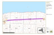
Route 104 Corridor Trail Feasibility Study - Genesee Transportation ...
Route 104 Corridor Trail Feasibility Study - Genesee Transportation ...
Route 104 Corridor Trail Feasibility Study - Genesee Transportation ...

Create successful ePaper yourself
Turn your PDF publications into a flip-book with our unique Google optimized e-Paper software.
INVENTORY AND ANALYSIS<br />
4<br />
<strong>Route</strong> <strong>104</strong> <strong>Corridor</strong> <strong>Trail</strong> <strong>Feasibility</strong> <strong>Study</strong><br />
A formal wetland delineation is needed to make a final determination of wetland and stream boundaries. The<br />
wetland delineation would need to be conducted according to the three-parameter methodology presented in the<br />
1987 Corps of Engineers Wetland Delineation Manual (Environmental Laboratory, 1987) and the updated<br />
methodologies presented in the Interim Regional Supplement to the Corps of Engineers Wetland Delineation Manual:<br />
Northcentral and Northeast Region (2009). A final determination of jurisdictional status can only be made after an<br />
on-site agency review of identified boundaries.<br />
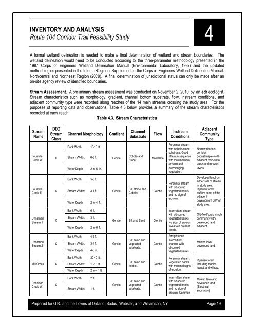
Stream Assessment. A preliminary stream assessment was conducted on November 2, 2010, by an edr ecologist.<br />
Stream characteristics such as morphology, gradient, channel bottom substrate, flow, instream conditions, and<br />
adjacent community type were recorded along reaches of the 14 main streams crossing the study area. For the<br />
purposes of reporting data and observations, Table 4.3 below provides a summary of the stream characteristics<br />
recorded at each reach.<br />
Table 4.3. Stream Characteristics<br />
Stream<br />
Name<br />
Fourmile<br />
Creek W<br />
DEC<br />
Stream<br />
Class<br />
C<br />
Channel Morphology<br />
Bank Width: 10-15 ft.<br />
Stream Width: 6-8 ft.<br />
Water Depth 2 in.-6 in.<br />
Gradient<br />
Gentle<br />
Channel<br />
Substrate<br />
Cobble and<br />
Stone<br />
Flow<br />
Moderate<br />
Instream<br />
Conditions<br />
Perennial stream<br />
with cobble/stone<br />
substrate. Good<br />
riffle/run sequence<br />
with minimal bank<br />
erosion and<br />
overhanging<br />
vegetation.<br />
Adjacent<br />
Community<br />
Type<br />
Narrow riparian<br />
corridor<br />
(locust/maple) with<br />
adjacent residential<br />
areas and mowed<br />
lawns.<br />
Fourmile<br />
Creek E<br />
C<br />
Bank Width:<br />
Stream Width:<br />
Water Depth<br />
5-8 ft.<br />
3-4 ft.<br />
2 in.-4 ft.<br />
Gentle<br />
Silt, stone and<br />
Cobble<br />
Gentle<br />
Perennial stream<br />
with obscured<br />
vegetated banks<br />
and no sign of<br />
erosion.<br />
Developed land on<br />
either side of stream<br />
in study area.<br />
Riparian forest<br />
buffers some of the<br />
adjacent<br />
development SW of<br />
study area.<br />
Unnamed<br />
Stream 1<br />
C<br />
Bank Width:<br />
Stream Width:<br />
Water Depth<br />
6 ft.<br />
3 ft.<br />
2 in.-6 ft.<br />
Gentle Silt and Sand Gentle<br />
Intermittent stream<br />
with obscured<br />
vegetated banks.<br />
No sign of erosion.<br />
Invasives present<br />
(reed).<br />
Old-field/scrub shrub<br />
community with<br />
developed land<br />
adjacent.<br />
Unnamed<br />
Stream 2<br />
C<br />
Bank Width:<br />
Stream Width:<br />
Water Depth<br />
4-5 ft.<br />
3-4 ft.<br />
4-6 in.<br />
Gentle<br />
Silt, sand and<br />
vegetated<br />
substrate.<br />
Gentle<br />
Straightened<br />
intermittent<br />
channel with<br />
obscured<br />
vegetated banks.<br />
Mowed lawn/<br />
developed land.<br />
Mill Creek<br />
C<br />
Bank Width:<br />
Stream Width:<br />
Water Depth<br />
30-40 ft.<br />
10-15 ft.<br />
2 in – 1 ft.<br />
Gentle<br />
Silt, sand and<br />
cobble.<br />
Gentle<br />
Perennial stream.<br />
Vegetated banks<br />
with minimal signs<br />
of erosion.<br />
Riparian forest<br />
including maple,<br />
locust, and willow.<br />
Dennison<br />
Creek W.<br />
C<br />
Bank Width:<br />
Stream Width:<br />
2 ft.<br />
1 ft.<br />
Gentle<br />
Silt, sand and<br />
vegetated<br />
substrate.<br />
Gentle<br />
Intermittent stream<br />
with obscured<br />
vegetated banks<br />
and no sign of<br />
erosion. Common<br />
Mowed lawn and<br />
developed land.<br />
(Electrical<br />
substation)<br />
Prepared for GTC and the Towns of Ontario, Sodus, Webster, and Williamson, NY Page 19