Route 104 Corridor Trail Feasibility Study - Genesee Transportation ...
Route 104 Corridor Trail Feasibility Study - Genesee Transportation ...
Route 104 Corridor Trail Feasibility Study - Genesee Transportation ...

Create successful ePaper yourself
Turn your PDF publications into a flip-book with our unique Google optimized e-Paper software.
INVENTORY AND ANALYSIS<br />
4<br />
<strong>Route</strong> <strong>104</strong> <strong>Corridor</strong> <strong>Trail</strong> <strong>Feasibility</strong> <strong>Study</strong><br />
C. CIRCULATION AND TRANSPORTATION<br />
The following section addresses pedestrian access, sidewalks, trails, roadways, intersections, and mass transit.<br />
1. Pedestrian Access<br />
Pedestrian access can be measured by Walk Score, an online tool that allows users to determine the walkability of a<br />
certain address based on the number of pedestrian generators in close proximity to that address. Walk Score<br />
calculates the walkability of an address by locating nearby pedestrian destinations such as stores, restaurants,<br />
schools, parks, etc.<br />
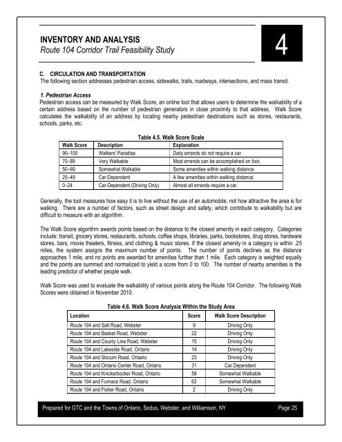
Table 4.5. Walk Score Scale<br />
Walk Score Description Explanation<br />
90–100 Walkers' Paradise Daily errands do not require a car.<br />
70–89 Very Walkable Most errands can be accomplished on foot.<br />
50–69 Somewhat Walkable Some amenities within walking distance.<br />
25–49 Car-Dependent A few amenities within walking distance.<br />
0–24 Car-Dependent (Driving Only) Almost all errands require a car.<br />
Generally, the tool measures how easy it is to live without the use of an automobile, not how attractive the area is for<br />
walking. There are a number of factors, such as street design and safety, which contribute to walkability but are<br />
difficult to measure with an algorithm.<br />
The Walk Score algorithm awards points based on the distance to the closest amenity in each category. Categories<br />
include: transit, grocery stores, restaurants, schools, coffee shops, libraries, parks, bookstores, drug stores, hardware<br />
stores, bars, movie theaters, fitness, and clothing & music stores. If the closest amenity in a category is within .25<br />
miles, the system assigns the maximum number of points. The number of points declines as the distance<br />
approaches 1 mile, and no points are awarded for amenities further than 1 mile. Each category is weighted equally<br />
and the points are summed and normalized to yield a score from 0 to 100. The number of nearby amenities is the<br />
leading predictor of whether people walk.<br />
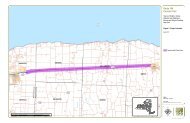
Walk Score was used to evaluate the walkability of various points along the <strong>Route</strong> <strong>104</strong> <strong>Corridor</strong>. The following Walk<br />
Scores were obtained in November 2010.<br />
Table 4.6. Walk Score Analysis Within the <strong>Study</strong> Area<br />
Location Score Walk Score Description<br />
<strong>Route</strong> <strong>104</strong> and Salt Road, Webster 9 Driving Only<br />
<strong>Route</strong> <strong>104</strong> and Basket Road, Webster 22 Driving Only<br />
<strong>Route</strong> <strong>104</strong> and County Line Road, Webster 15 Driving Only<br />
<strong>Route</strong> <strong>104</strong> and Lakeside Road, Ontario 14 Driving Only<br />
<strong>Route</strong> <strong>104</strong> and Slocum Road, Ontario 23 Driving Only<br />
<strong>Route</strong> <strong>104</strong> and Ontario Center Road, Ontario 31 Car Dependent<br />
<strong>Route</strong> <strong>104</strong> and Knickerbocker Road, Ontario 58 Somewhat Walkable<br />
<strong>Route</strong> <strong>104</strong> and Furnace Road, Ontario 62 Somewhat Walkable<br />
<strong>Route</strong> <strong>104</strong> and Fisher Road, Ontario 2 Driving Only<br />
Prepared for GTC and the Towns of Ontario, Sodus, Webster, and Williamson, NY Page 25