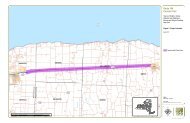
Route 104 Corridor Trail Feasibility Study - Genesee Transportation ...
Route 104 Corridor Trail Feasibility Study - Genesee Transportation ...
Route 104 Corridor Trail Feasibility Study - Genesee Transportation ...

You also want an ePaper? Increase the reach of your titles
YUMPU automatically turns print PDFs into web optimized ePapers that Google loves.
EXECUTIVE SUMMARY<br />
1<br />
<strong>Route</strong> <strong>104</strong> <strong>Corridor</strong> <strong>Trail</strong> <strong>Feasibility</strong> <strong>Study</strong><br />
Property ownership adjacent to the trail corridor was assessed, as well as easements and rights of way within the<br />
study area. A significant number of properties (and their associated driveways) are located in the area immediately<br />
adjacent to the <strong>Route</strong> <strong>104</strong> R.O.W. Other easements and rights of way were inventoried within the study area that<br />
could potentially be used to accommodate a multi-use trail. These include County Road 103/ Ridge Road, Ontario-<br />
Midland Railroad, and property that is owned/accessed by the Town of Ontario for trail development.<br />
Over the past few years, the Town of Ontario has been developing an east-west trail across the Town. Town officials<br />
have negotiated access, used Town land, or acquired new properties to create 5.5 miles of multi-use trail. 3.6 miles<br />
are built or in development and 1.9 miles are in the process of negotiation. The planned Ontario trail extends from<br />
Dean Parkway in the west to just beyond Furnace Road in the east. Town officials expressed their desire to connect<br />
the <strong>Route</strong> <strong>104</strong> <strong>Corridor</strong> <strong>Trail</strong> to this trail, rather than create a parallel trail nearby.<br />
In regards to circulation and transportation, the following characteristics were assessed during the study: pedestrian<br />
access, sidewalks, trails, roadways, intersections, and mass transit. All of the roads that intersect with <strong>Route</strong> <strong>104</strong><br />
within the study area boundary were inventoried and assessed. The intersection summary includes ownership,<br />
functional classification, general physical and operational characteristics, and average daily traffic volume (ADT).<br />
Basic gap studies were conducted at four of the road crossings along the Railroad <strong>Trail</strong>/Town of Ontario <strong>Trail</strong><br />
alignment. Roads were selected based on the ADT.<br />
There are a number of factors to consider when locating a trail. Topography, soils, ecological character, habitat,<br />
drainage, wetlands, land use, destinations, property ownership, access, circulation and transportation are all matters<br />
that were evaluated. Of these factors, only a few presented significant constraints. Providing safe access to a trail<br />
located in the <strong>Route</strong> <strong>104</strong> R.O.W. did not seem promising once the constraints were mapped, which led to the<br />
consideration of other solutions.<br />
Alternatives. The alternatives that are described in detail are not the alternatives that were anticipated at the<br />
beginning of the study. When it was determined that the right-of-way was not the best place for a trail, there was a<br />
need to think differently about possible solutions. The goal of the study – to have a safe corridor where nonmotorized<br />
users could travel between Sodus and Webster – could be achieved in a few different ways.<br />
Alternative 1 is a multi-use trail located in the expanded right-of-way of the Ontario Midland Railroad. In addition to<br />
being safer, the trail corridor is more scenic than <strong>Route</strong> <strong>104</strong>. According to authorities at Ontario Midland, who<br />
operate in a corridor owned by Rochester Gas and Electric/Iberdrola USA, a 25-foot expansion of the railroad rightof-way<br />
is planned. The proposed trail could easily fit into this enlarged right-of-way, and would allow a public benefit<br />
to be associated with a right-of-way expansion that might be controversial to some landowners.<br />
Alternative 2 offers an active transportation package that expands on the existing transportation network, which is a<br />
different type of solution altogether. Instead of creating a new trail, this alternative proposes a package of<br />
transportation enhancements that would make Ridge Road more bicycle and pedestrian friendly. The proposal is a<br />
rural application of complete streets principles, and though using a different approach, still achieves many of the<br />
objectives of the study. In addition to improvements to Ridge Road, this alternative recommends improving bicycle<br />
and pedestrian connections between Ridge Road and <strong>Route</strong> <strong>104</strong>.<br />
The other alternatives considered, which are not recommended, are multi-use trail alignments located on the north<br />
and the south sides of the <strong>Route</strong> <strong>104</strong> right-of-way. The proximity to <strong>Route</strong> <strong>104</strong> would allow for good access to many<br />
destinations, but the location would create a less desirable trail user experience. <strong>Trail</strong> users would have to deal with<br />
Prepared for GTC and the Towns of Ontario, Sodus, Webster, and Williamson, NY Page 6