Copertina AV6 europa ing.indd - Dolomiti Turismo
Copertina AV6 europa ing.indd - Dolomiti Turismo
Copertina AV6 europa ing.indd - Dolomiti Turismo

Create successful ePaper yourself
Turn your PDF publications into a flip-book with our unique Google optimized e-Paper software.
The refuge bears the name of Elberfeld, a suburb of the large city of<br />
Wuppertal, in Nordrhein – Westphalia. The outbreak of World War One meant that<br />
build<strong>ing</strong> was postponed until 1925. After two years’ work, on the 8th of August<br />
1928, it was inaugurated. Today, the Elberfelder Hütte is a modern refuge, which<br />
has obtained the environmental quality stamp of the German Alpine Club.<br />
Day three<br />
From the Elberfelder Hütte to the Adolf Noßberger Hütte<br />
Time required: 4 hours<br />
Maximum altitude: Klammerscharte, 2930m<br />
Gradient in ascent: 600m<br />
Difficulty: Red and Black (EE, Expert Hikers and EEA Expert Hikers<br />
with Equipment)<br />
Path: N.921<br />
Maps: Alpenvereinskarte n.41, Schobergruppe, 1: 25,000<br />
This stage is the highest point on the route, and also covers the most<br />
difficult stretch from a mountaineer<strong>ing</strong> point of view. You have a choice of two<br />
variants, neither of which is easy:<br />
1- pass the ice-covered area of the Klammerscharte, 2930m, between the<br />
Klammerköpfen and the Hornköpfen;<br />
2- conquer to the north-east the Hornscharte, 2958m, extraordinarily steep,<br />
between the Großer Hornkopf and the Kreuzkopf<br />
Before choos<strong>ing</strong> a route, it is imperative that you find out from the manager<br />
of the Elberfelder Hütte about the condition of the tracks. Generally speak<strong>ing</strong>,<br />
the follow<strong>ing</strong> rule of thumb is valid: at the beginn<strong>ing</strong> of the summer, until a layer<br />
of “firn” (hardened spr<strong>ing</strong> snow) covers the Großnitzkees and this glaciers allows<br />
you to climb up to the Klammerscharte, the first option is preferable. Later on in<br />
the summer, as the snow disappears, the Hornscharte variant is better, because<br />
the ice has melted, although it is steeper. Both variants are described below.<br />
From the Elderfelder Hütte, follow the marked path through the<br />
clearly marked edges of the glacier and the head of the Gößnitztal,<br />
dominated by the seven peaks of the Klammerköpfe, separated from<br />
each other by extremely steep snow-filled channels. You soon reach<br />
a fork, from where you follow the track towards east, marked as<br />
Klammerscharte.<br />
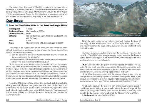
„Großer Gradensee“ lake<br />
at the bottom; the overhang<strong>ing</strong> notch is the „Klammerscharte” saddle (2.930m)<br />
Now the path winds its way steeply up and crosses the base of<br />
the long, broken north-west crest of the Großer Hornkopf, 3251m,<br />
and finally reaches the edge of the glacier in an area scattered with<br />
morainic rocks.<br />
The high mountain landscape inspires the profound respect of the<br />
traveller. The Gößnitzkees sweeps steeply down towards the bottom<br />
of the narrow passage of the Klammerscharte, bordered by dark rock<br />
walls and snow-covered channels.<br />
N.B.! Especially when the glacier becomes exposed, crevasses open up,<br />
and a fall here could have fatal consequences. Climbers attempt<strong>ing</strong> this route<br />
should therefore have some experience of glaciers, as well as appropriate equipment<br />
(crampons, ice-axes, secur<strong>ing</strong> ropes; difficulty level EEA)<br />
If you follow this advice, cross<strong>ing</strong> of the Klammerscharte is sure to be an<br />
unforgettable mountaineer<strong>ing</strong> experience. The climb up the glacier, which is very<br />
steep, is accompanied by an increas<strong>ing</strong>ly strik<strong>ing</strong> landscape ; particularly impressive<br />
is the nearby Roter Kopf, 3281m, and then the Großglockner, 3798m.<br />
You finally reach, in the steepest part of the glacier, some recently<br />
positioned metal safety ropes which, along the north edge of the<br />
branch of the glacier which here almost becomes a couloir, lead<br />
directly to the narrow rock window of the Klammerscharte, 2930m.<br />
2,30 hours from the Ebelferder Hütte.<br />
32 HIGH ALTITUDE GROßGLOCKNER-MONTE PERALBA EUROPA HIGH-ALTITUDE TRAIL 6 33