Copertina AV6 europa ing.indd - Dolomiti Turismo
Copertina AV6 europa ing.indd - Dolomiti Turismo
Copertina AV6 europa ing.indd - Dolomiti Turismo

Create successful ePaper yourself
Turn your PDF publications into a flip-book with our unique Google optimized e-Paper software.
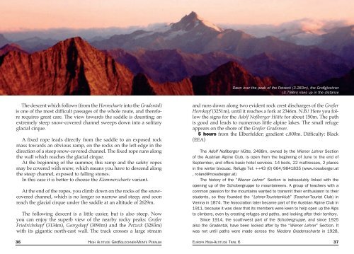
Dawn over the peak of the Petzeck (3.283m), the Großglockner<br />
(3.798m) rises up in the distance<br />
The descent which follows (from the Hornscharte into the Gradental)<br />
is one of the most difficult passages of the whole route, and therefore<br />
requires great care. The view towards the saddle is daunt<strong>ing</strong>; an<br />
extremely steep snow-covered channel sweeps down into a solitary<br />
glacial cirque.<br />
A fixed rope leads directly from the saddle to an exposed rock<br />
mass towards an obvious ramp, on the rocks on the left edge in the<br />
direction of a steep snow-covered channel. The fixed rope runs along<br />
the wall which reaches the glacial cirque.<br />
At the beginn<strong>ing</strong> of the summer, this ramp and the safety ropes<br />
may be covered with snow, which means you have to descend along<br />
the steep channel, exposed to fall<strong>ing</strong> stones.<br />
In this case it is better to choose the Klammerscharte variant.<br />
At the end of the ropes, you climb down on the rocks of the snowcovered<br />
channel, which is no longer so narrow and steep, and soon<br />
reach the glacial cirque under the saddle at an altitude of 2629m.<br />
The follow<strong>ing</strong> descent is a little easier, but is also steep. Now<br />
you can enjoy the superb view of the nearby rocky peaks: Großer<br />
Friedrichskopf (3134m), Georgskopf (3090m) and the Petzeck (3283m)<br />
with its gigantic north-east wall. The track crosses a large stream<br />
and runs down along two evident rock crest discharges of the Großer<br />
Hornkopf (3251m), until it reaches a fork at 2346m. N.B.! Here you follow<br />
the signs for the Adolf Noßberger Hütte for about 150m. The path<br />
is good and leads to numerous little alpine lakes. The small refuge<br />
appears on the shore of the Großer Gradensee.<br />
5 hours from the Elberfelder; gradient c.800m. Difficulty: Black<br />
(EEA)<br />
The Adolf Noßberger Hütte, 2488m, owned by the Wiener Lehrer Section<br />
of the Austrian Alpine Club, is open from the beginn<strong>ing</strong> of June to the end of<br />
September, and offers basic hotel services. 14 beds, 22 mattresses, 2 places<br />
in the winter bivouac. Refuge Tel: ++43 (0) 664/9841835 (www.nossberger.at<br />
, roland@nossberger.at)<br />
The history of the “Wiener Lehrer” Section is indissolubly linked with the<br />
open<strong>ing</strong> up of the Schobergruppe to mountaineers. A group of teachers with a<br />
common passion for the mountains wanted to transmit their enthusiasm to their<br />
students, so they founded the “Lehrer-Touristenklub” (Teacher-Tourist Club) in<br />
Vienna in 1874. The Association later became part of the Austrian Alpine Club in<br />
1911, because it was clear that its members were keen to help open up the Alps<br />
to climbers, even by creat<strong>ing</strong> refuges and paths, and look<strong>ing</strong> after their territory.<br />
Since 1914, the south-west part of the Schobergruppe, and since 1925<br />
also the Gradental, have been looked after by the “Wiener Lehrer” Section. It<br />
was not until paths were made across the Niedere Gradenscharte in 1928,<br />
36 HIGH ALTITUDE GROßGLOCKNER-MONTE PERALBA EUROPA HIGH-ALTITUDE TRAIL 6 37