Copertina AV6 europa ing.indd - Dolomiti Turismo
Copertina AV6 europa ing.indd - Dolomiti Turismo
Copertina AV6 europa ing.indd - Dolomiti Turismo

Create successful ePaper yourself
Turn your PDF publications into a flip-book with our unique Google optimized e-Paper software.
At Erto you can find food and drink at the Locanda Julia in IX<br />
Ottobre 32, tel. 0427 879080. To rent rooms call 0427 879006.<br />
From Erto to Cimolàis (652m) you follow the Statale 251, which<br />
passes San Martino. Cross over the Passo di San Osvaldo (828m) and<br />
descend to the delightful village after about 7 kilometres.<br />
Of course you can use the bus (the Longarone-Erto-Cimolàis-Claut line;<br />
check the timetable) or you can ask a kind-hearted soul for a lift or finally<br />
you can use the old “caval di San Francesco” (mean<strong>ing</strong> your own two<br />
feet!). You can also find food, drink and rooms to rent at Cimolàis.<br />
About 2 hours, on foot, from Erto to Cimolàis.<br />
About 8 hours from Bivacco Greselìn.<br />
Variant VI<br />
From the Rifugio Maniago to Erto along the “Sentiero<br />
alpinistico Osvaldo Zandonella”<br />
This is a “crag walk” for experts. There are some tricky stretches on the<br />
rock face, aided by fixed ropes. Fantastic views. The path was created in 1978<br />
by the “Gruppo Amici della Montagna di Onigo di Piave”(Friends of the mountains)<br />
who have also maintained it for years. Some fixed ropes have been replaced<br />
or been put in use again by those assigned by the region for maintenance<br />
and upkeep. The route isn’t difficult, just very rough.<br />
The path is divided into two stretches. The FIRST you can find described<br />
below. The SECOND STRETCH is not recommended as it is much harder and has<br />
had some fixed apparatus removed due to continuous damage from fall<strong>ing</strong> rocks<br />
or landslides. They both remain, however, two fantastically beautiful routes.<br />
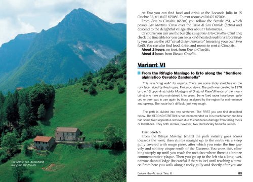
The Monte Tòc, descend<strong>ing</strong><br />
along the Val Zémola<br />
First Stretch<br />
From the Rifugio Maniago (chart) the path initially goes across<br />
towards the west, then climbs straight up to the north via a steep<br />
gully covered with mugo pines, after which you enter the fine gravely<br />
and solitary cirque south of the Duranno. You cross this, climb<strong>ing</strong><br />
steeply up until you reach the rock face where there is a bronze<br />
commemorative plaque. Then you go up to the left via a long, wet,<br />
narrow slanted ledge (be careful if there is ice) until reach<strong>ing</strong> a terrace.<br />
From here you walk along a rocky gully and shortly after you are<br />
84 THE DOLOMITES "ALTA VIA" N. 6 OR “DEI SILENZI” EUROPA HIGH-ALTITUDE TRAIL 6 85