Ore Bin / Oregon Geology magazine / journal - Oregon Department ...
Ore Bin / Oregon Geology magazine / journal - Oregon Department ...
Ore Bin / Oregon Geology magazine / journal - Oregon Department ...
Create successful ePaper yourself
Turn your PDF publications into a flip-book with our unique Google optimized e-Paper software.
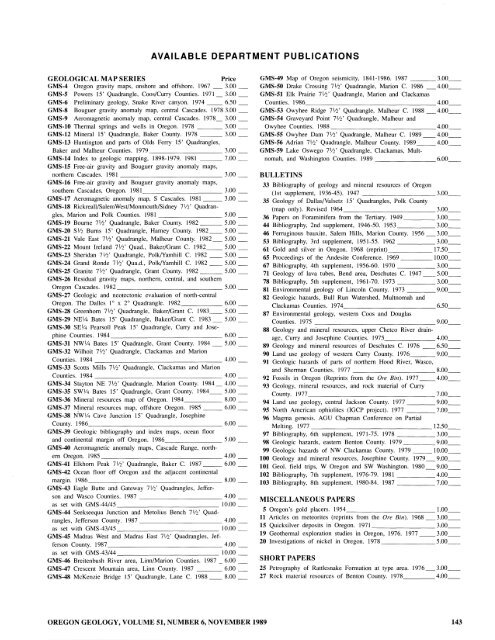
AVAILABLE DEPARTMENT PUBLICATIONS<br />
GEOLOGICAL MAP SERIES<br />
Price<br />
GMS-4 <strong>Ore</strong>gon gravity maps, onshore and offshore. 1967 3.00<br />
GMS-5 Powers 15' Quadrangle, Coos/Curry Counties. 1971_ 3.00 _<br />
GMS-6 Preliminary geology, Snake River canyon. 1974 __ 6.50 _<br />
GMS-8 Bouguer gravity anomaly map, central Cascades. 1978 3.00 _<br />
GMS-9 Aeromagnetic anomaly map, central Cascades. 1978_ 3.00 _<br />
GMS-10 Thermal springs and wells in <strong>Ore</strong>gon. 1978 3.00<br />
GMS-12 Mineral 15' Quadrangle, Baker County. 1978 ___ 3.00_<br />
GMS-13 Huntington and parts of 01ds Ferry 15' Quadrangles,<br />
Baker and Ma1heur Counties. 1979 3.00<br />
GMS-14 Index to geologic mapping, 1898-1979. 1981 ___ 7.00 _<br />
GMS-15 Free-air gravity and Bouguer gravity anomaly maps,<br />
northern Cascades. 1981 3.00<br />
GMS-16 Free-air gravity and Bouguer gravity anomaly maps,<br />
southern Cascades, <strong>Ore</strong>gon. 1981 3.00<br />
GMS-17 Aeromagnetic anomaly map, S Cascades. 1981 ___ 3.00 _<br />
GMS-18 Rickreall/SalemWest/Monmouth/Sidney 7W Quadrangles,<br />
Marion and Polk Counties. 1981 5.00<br />
GMS-19 Bourne 7lf2' Quadrangle, Baker County. 1982 ___ 5.00 _<br />
GMS-20 Slf2 Burns 15' Quadrangle, Harney County. 1982 __ 5.00 _<br />
GMS-21 Vale East 7lf2' Quadrangle, Ma1heur County. 1982_ 5.00 _<br />
GMS-22 Mount Ireland 7W Quad., Baker/Grant C. 1982 __ 5.00 __<br />
GMS-23 Sheridan 7W Quadrangle, PolklYamhill C. 1982 __ 5.00 _<br />
GMS-24 Grand Ronde 7Y2' Qua.d., Po1k/Yamhill C. 1982 __ 5.00 _<br />
GMS-25 Granite 7lf2' Quadrangle, Grant County. 1982 ___ 5.00 __<br />
GMS-26 Residual gravity maps, northern, central, and southern<br />
<strong>Ore</strong>gon Cascades. 1982 5.00<br />
GMS-27 Geologic and neotectonic evaluation of north-central<br />
<strong>Ore</strong>gon. The Dalles lOx 2° Quadrangle. 1982 6.00<br />
GMS-28 Greenhorn 7lf2' Quadrangle, Baker/Grant C. 1983 __ 5.00 _<br />
GMS-29 NElf4 Bates 15' Quadrangle, Baker/Grant C. 1983 _ 5.00 _<br />
GMS-30 SEY4 Pearsoll Peak 15' Quadrangle, Curry and Josephine<br />
Counties. 1984 6.00<br />
GMS-31 NWlf4 Bates 15' Quadrangle, Grant County. 1984 _ 5.00 _<br />
GMS-32 Wilhoit 7lf2' Quadrangle, Clackamas and Marion<br />
Counties. 1984 4.00<br />
GMS-33 Scotts Mills 7lf2' Quadrangle, Clackamas and Marion<br />
Counties. 1984 4.00<br />
GMS-34 Stayton NE 7 W Quadrangle, Marion County. 1984 _ 4.00 _<br />
GMS-35 SWY4 Bates 15' Quadrangle, Grant County. 1984 ___ 5.00 ___<br />
GMS-36 Mineral resources map of <strong>Ore</strong>gon. 1984 8.00<br />
GMS-37 Mineral resources map, offshore <strong>Ore</strong>gon. 1985 ___ 6.00 _<br />
GMS-38 NWlf4 Cave Junction 15' Quadrangle, Josephine<br />
County. 1986 6.00<br />
GMS-39 Geologic bibliography and index maps, ocean floor<br />
and continental margin off <strong>Ore</strong>gon. 1986 5.00<br />
GMS-40 Aeromagnetic anomaly maps, Cascade Range, northern<br />
<strong>Ore</strong>gon. 1985 4.00<br />
GMS-41 Elkhorn Peak 7 W Quadrangle, Baker C. 1987 __ 6.00 _<br />
GMS-42 Ocean floor off <strong>Ore</strong>gon and the adjacent continental<br />
margin. 1986 8.00<br />
GMS-43 Eagle Butte and Gateway 7Y2' Quadrangles, Jefferson<br />
and Wasco Counties. 1987 4.00<br />
as set with GMS-44/45 10.00<br />
GMS-44 Seekseequa Junction and Metolius Bench 7Y2' Quadrangles,<br />
Jefferson County. 1987 4.00<br />
as set with GMS-43/45 10.00<br />
GMS-45 Madras West and Madras East 7lf2' Quadrangles, Jefferson<br />
County. 1987 4.00<br />
as set with GMS-43/44 10.00<br />
GMS-46 Breitenbush River area, LinnlMarion Counties. 1987 _ 6.00 _<br />
GMS-47 Crescent Mountain area, Linn County. 1987 6.00<br />
GMS-48 McKenzie Bridge 15' Quadrangle, Lane C. 1988 8.00<br />
GMS-49 Map of <strong>Ore</strong>gon seismicity, 1841-1986. 1987 3.00 __<br />
GMS-50 Drake Crossing 7W Quadrangle, Marion C. 1986 4.00<br />
GMS-51 Elk Prairie 7lf2' Quadrangle, Marion and Clackamas<br />
Counties. 1986 4.00<br />
GMS-53 Owyhee Ridge 7W Quadrangle, Malheur C. 1988 _4.00__<br />
GMS-54 Graveyard Point 7lf2' Quadrangle, Malheur and<br />
Owyhee Counties. 1988<br />
4.00 __<br />
GMS-55 Owyhee Dam 7W Quadrangle, Malheur C. 1989 __ 4.00 __<br />
GMS-56 Adrian 7Y2' Quadrangle, Malheur County. 1989 ___ 4.00 __<br />
GMS-59 Lake Oswego 7lf2' Quadrangle, Clackamas, Multnomah,<br />
and Washington Counties. 1989 6.00<br />
BULLETINS<br />
33 Bibliography of geology and mineral resources of <strong>Ore</strong>gon<br />
(1st supplement, 1936-45). 1947<br />
3.00 __<br />
35 <strong>Geology</strong> of DailasIValsetz 15' Quadrangles, Polk County<br />
(map only). Revised 1964 3.00<br />
36 Papers on Foraminifera from the Tertiary. 1949 3.00<br />
44 Bibliography, 2nd supplement, 1946-50. 1953 3.00 __<br />
46 Ferruginous bauxite, Salem Hills, Marion County. 1956 3.00 __<br />
53 Bibliography, 3rd supplement, 1951-55. 1962 3.00 __<br />
61 Gold and silver in <strong>Ore</strong>gon. 1968 (reprint) 17.50 __<br />
65 Proceedings of the Andesite Conference. 1969 10.00<br />
67 Bibliography, 4th supplement, 1956-60. 1970 3.00<br />
71 <strong>Geology</strong> of lava tubes, Bend area, Deschutes C. 1947 __ 5.00 __<br />
78 Bibliography, 5th supplement, 1961-70. 1973 3.00<br />
81 Environmental geology of Lincoln County. 1973 9.00<br />
82 Geologic hazards, Bull Run Watershed, Multnomah and<br />
Clackamas Counties. 1974<br />
6.50 __<br />
87 Environmental geology, western Coos and Douglas<br />
Counties. 1975 9.00<br />
88 <strong>Geology</strong> and mineral resources, upper Chetco River drainage,<br />
Curry and Josephine Counties. 1975<br />
4.00 __<br />
89 <strong>Geology</strong> and mineral resources of Deschutes C. 1976 __ 6.50 __<br />
90 Land use geology of western Curry County. 1976 9.00 __<br />
91 Geologic hazards of parts of northern Hood River, Wasco,<br />
and Sherman Counties. 1977 8.00<br />
92 Fossils in <strong>Ore</strong>gon (Reprints from the <strong>Ore</strong> <strong>Bin</strong>). 1977 __ 4.00 __<br />
93 <strong>Geology</strong>, mineral resources, and rock material of Curry<br />
County. 1977 7.00<br />
94 Land use geology, central Jackson County. 1977 9.00 __<br />
95 North American ophiolites (IGCP project). 1977 7.00 __<br />
96 Magma genesis. AGU Chapman Conference on Partial<br />
Melting. 1977 12.50<br />
97 Bibliography, 6th supplement, 1971-75. 1978 3.00 __<br />
98 Geologic hazards, eastern Benton County. 1979 9.00<br />
99 Geologic hazards of NW Clackamas County. 1979 ___ 10.00 __<br />
100 <strong>Geology</strong> and mineral resources, Josephine County. 1979_9.00 __<br />
101 Geol. field trips, W <strong>Ore</strong>gon and SW Washington. 1980 9.00<br />
102 Bibliography, 7th supplement, 1976-79. 1981 4.00 __<br />
103 Bibliography, 8th supplement, 1980-84. 1987 7.00<br />
MISCELLANEOUS PAPERS<br />
5 <strong>Ore</strong>gon's gold placers. 1954 ____________ 1.00<br />
11 Articles on meteorites (reprints from the <strong>Ore</strong> <strong>Bin</strong>). 1968 3.00<br />
15 Quicksilver deposits in <strong>Ore</strong>gon. 1971 3.00<br />
19 Geothermal exploration studies in <strong>Ore</strong>gon, 1976. 1977 3.00 __<br />
20 Investigations of nickel in <strong>Ore</strong>gon. 1978 5.00<br />
SHORT PAPERS<br />
25 Petrography of Rattlesnake Formation at type area. 1976 3.00<br />
27 Rock material resources of Benton County. 1978 4.00<br />
OREGON GEOLOGY, VOLUME 51, NUMBER 6, NOVEMBER 1989 143


