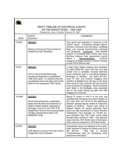
19401949 DRAFT TIMELINE.pdf - Skagit River History
19401949 DRAFT TIMELINE.pdf - Skagit River History
19401949 DRAFT TIMELINE.pdf - Skagit River History

You also want an ePaper? Increase the reach of your titles
YUMPU automatically turns print PDFs into web optimized ePapers that Google loves.
<strong>DRAFT</strong> <strong>TIMELINE</strong> OF HISTORICAL EVENTS<br />
ON THE SKAGIT RIVER – 1940-1949<br />
Prepared by: Larry J. Kunzler, February 23, 1996<br />
DATE<br />
EVENT/<br />
Document<br />
COMMENTS<br />
7/30/40 REPORT<br />
7/5/40 REPORT<br />
12/1940 REPORT<br />
6/15/42 REPORT<br />
Report on Survey for Flood Control of<br />
<strong>Skagit</strong> <strong>River</strong> and Tributaries<br />
W.P.A. Flood Control Work (was<br />
included as Appendix to unpublished<br />
1942 COE report. It is believed that this<br />
unpublished report was later used as the<br />
basis for the subsequent 1952 report).<br />
Flood Control Economic Justification<br />
Study Avon By-Pass and Extension of<br />
Dikes to Sedro Woolley, Appraisal of<br />
Damages 1815 H.W. and 1921 H.W.<br />
<strong>Skagit</strong> <strong>River</strong> West of and including Sedro<br />
Woolley--Samish <strong>River</strong> Delta, H.R.<br />
MADISON 12/40<br />
COE Report on Survey for Flood Control<br />
<strong>Skagit</strong> <strong>River</strong> And Tributaries<br />
This report was prepared in response to the<br />
3/29/37 report. Considered storage (dams),<br />
diversion channels (Avon By-Pass), modifying<br />
dikes and channel improvements (widening<br />
and riprapping). Conclusion: Only feasible<br />
method of providing flood control was Avon<br />
By-Pass however local government cannot<br />
afford it. Recommendation: Continue<br />
snagging of <strong>Skagit</strong> upstream of Sedro Woolley<br />
at cost of $10,000 per year.<br />
3 major flood related projects were identified.<br />
#1 spent $269,349, used 198 men and took<br />
almost 3yrs to complete. Involved extensive<br />
brush revetment work in 6 locations between<br />
Burlington & Hamilton. #2 spent $41,221,<br />
used 70 men and involved snagging btwn<br />
Hamilton & Marblemount. #3 was on the Sauk<br />
<strong>River</strong> used 63 men, cost $42,032 and involved<br />
brush revetment & snagging. Brush revetment<br />
work failed in the Burlington area reportedly<br />
due to log boats towing log rafts and rafts<br />
dragging on revetment.<br />
Report is unique in that it is the only one<br />
identified that compares two distinct floods (in<br />
this case 1921 and 1815) for the differences<br />
between damage figures related to respective<br />
heights of flooding. Report was critical of<br />
Stewart Report as having estimated flood<br />
levels too high downstream of Sedro Woolley.<br />
Established "zero damage" at 110,000 cfs.,<br />
and estimated that 1921 flood would break<br />
through dikes existing in 1940. Has attached<br />
maps showing 1921 flood levels in Burlington,<br />
Clear Lake as compared to 1815 flood levels.<br />
Unpublished report not released to the public.<br />
Later returned to Division for further work by ltr<br />
dtd 8/21/42. Was told to develop<br />
"comprehensive plan for developing water<br />
resources of the basin."
<strong>DRAFT</strong> <strong>TIMELINE</strong> OF HISTORICAL EVENTS<br />
ON THE SKAGIT RIVER – 1940-1949<br />
Prepared by: Larry J. Kunzler, February 23, 1996<br />
DATE<br />
EVENT/<br />
Document<br />
COMMENTS<br />
1946 Second phase of Ross Dam completed.<br />
The <strong>Skagit</strong> Dams, Josef Kunzler, 1991<br />
5/8/46 LETTER To District Engineer, Seattle<br />
from Senator Jackson<br />
7/3/46 LETTER To Division Engineer, North<br />
Pacific Division, from District Engineer,<br />
Seattle Division<br />
7/29/46 LETTER To COE fm <strong>Skagit</strong> County re<br />
Skiyou Island.<br />
9/27/46 LETTER To Division Engineer, North<br />
Pacific Division, from District Engineer,<br />
Seattle Division<br />
Raised height of dam another 195 feet to 495<br />
feet.<br />
Senator responded to letter writing campaign<br />
began by Sedro Woolley residents Mr. & Mrs.<br />
Frank Neble. They owned a farm near Skiyou<br />
Island and were concerned about river<br />
erosion. Lost their driveway, orchard and<br />
barn. The Neble's continued writing letters<br />
through 11/46.<br />
COE does not feel that local cooperation will<br />
be forthcoming on any flood control project at<br />
this time. Requested local govt not be<br />
contacted until completion of ongoing survey<br />
report.<br />
Several letters were identified with respect to a<br />
small dike on Skiyou Island presumably built<br />
by the County to keep river "in its channel" and<br />
from coming in the back door to Sedro<br />
Woolley. COE felt that even if main stem of<br />
river jumped to Skiyou river channel near<br />
Sedro Woolley would be little changed and<br />
refused to get involved.<br />
Regarding flood control storage in Ross<br />
Reservoir. Ltr states storage in Diablo<br />
reduced peak of 1932 flood at Sedro Woolley<br />
by 26,000 cfs. If Ross was built no storage<br />
would be available behind Diablo because of<br />
"efficient power generation". COE wanted<br />
200,000 acre feet of storage behind Ross<br />
Dam. Storage to be in affect from November<br />
1st to April 1st. Also established instream flow<br />
at 1,150 acre feet during 24hr period.
<strong>DRAFT</strong> <strong>TIMELINE</strong> OF HISTORICAL EVENTS<br />
ON THE SKAGIT RIVER – 1940-1949<br />
Prepared by: Larry J. Kunzler, February 23, 1996<br />
DATE<br />
EVENT/<br />
Document<br />
COMMENTS<br />
11/20/46 LETTER To Federal Power Commission<br />
from Brigadier General R.C. Crawford,<br />
Acting Chief of COE<br />
12/11/46 LETTER To Mrs. Frank Neble from<br />
Colonel Hewitt COE<br />
1/16/47 LETTER<br />
To Division Engineer, Portland from<br />
District Engineer, Seattle<br />
4/29/47 ORDER<br />
U.S. Federal Power Commission<br />
8/15/47 LETTER AND PETITION<br />
To District Engineer from <strong>Skagit</strong> County<br />
residents in Burlington Bend area.<br />
In re flood control storage in Ross Reservoir.<br />
Storage between elevations 1710 & 1735<br />
would provide 300,000 acre feet of flood<br />
storage. Would be needed to control floods of<br />
record. 200,000 acre feet needed to control<br />
floods since 1909. Dam only being built to<br />
elev. 1600 (top of gates). Recommended<br />
flood storage be provided between November<br />
1st and April 1st. Would have allowed flood<br />
waters to be released at 10,000 cfs until level<br />
drops to 1582.5.<br />
In response to Mrs. Neble letter to the<br />
President, the COE preformed work on Skiyou<br />
Island. Subsequent letter (12/13/46) by Mrs.<br />
Neble blamed log raft towboats (Elwa) for<br />
damage to riverbank. COE did not want to<br />
restrict log towboats because of effects on<br />
timber industry.<br />
Concern expressed by request that 200,000<br />
acre feet flood storage be required behind<br />
Ross from 1 Oct to 1 May instead of 1 Nov to 1<br />
Apr.<br />
Issues order approving construction of third<br />
step of Ross Dam, requiring 200,000 acre feet<br />
of flood storage between November 1 and<br />
April 1. Draw down to be accomplished by<br />
Nov 1st. Flood gates to be opened and<br />
uncontrolled when elevation hits 1600 ft and to<br />
remain so until level comes back down to 1600<br />
ft. Waters can be released up to 10,000 cfs<br />
until level drops to 1582.5.<br />
Letter states in last 18 months, Austin Lytle<br />
lost 24 acres. Wanted channel straighten<br />
across ox bow. Project needed to protect<br />
Burlington. Has attached map showing<br />
movement of Burlington Bend from 1936 &<br />
projected to 1956. Concern from Burlington<br />
Mayor Dick Wilson was that river would link up<br />
with Gages Slough or Samish <strong>River</strong>. Felt state<br />
of emergency existed. Citizens did not want<br />
revetment work, preferred channel change.
<strong>DRAFT</strong> <strong>TIMELINE</strong> OF HISTORICAL EVENTS<br />
ON THE SKAGIT RIVER – 1940-1949<br />
Prepared by: Larry J. Kunzler, February 23, 1996<br />
DATE<br />
EVENT/<br />
Document<br />
COMMENTS<br />
8/27/47 REPORT<br />
Condition Investigation Report of WPA<br />
work referenced completed on 7/5/40<br />
9/25/47 LETTER<br />
To COE Division Engineer from District<br />
Engineer<br />
1/20/48 MEMORANDUM<br />
To Col. Hewitt from Pease<br />
RE: Burlington Bend Bank Erosion<br />
2/11/48 MEMORANDUM<br />
To Col. Hewitt from Pease<br />
RE: Burlington Bend Bank Erosion<br />
2/25/48 LETTER To COE fm <strong>Skagit</strong> County<br />
Commissioners<br />
RE: Burlington Bend Project<br />
Work done on Utopia suffered heavy<br />
damages. Just below work done on Neble<br />
area of Skiyou. Blamed work on Neble area<br />
as establishing new channel and shifted flow<br />
to opposite side of river. All 1940 projects<br />
suffered heavy damage and river continued<br />
erosion.<br />
Addressed scope of flood control work on<br />
<strong>Skagit</strong>. Felt only power generating & flood<br />
control sites on <strong>Skagit</strong> basin were in principal<br />
spawning grounds of <strong>Skagit</strong> <strong>River</strong>. Suggested<br />
US Fish & Wildlife would object.<br />
County engineer Walberg called re emergency<br />
project at Burlington Bend. County & state<br />
were willing to go ahead with cut-off project<br />
last year. Project dropped when local interest<br />
could not meet navigational terms of permit.<br />
Would have required maintenance dredging.<br />
(See 8/15/47 letter and petition.) County opted<br />
for rock rip rap instead. Wondered why county<br />
would only spend $50,000 now when last<br />
summer was going to spend $100,000.<br />
Felt river might flow through Burlington or<br />
northwesterly through Joe Leary Slough or<br />
Samish <strong>River</strong>. Used 1937 aerial photographs<br />
to show how bend had increased in size and<br />
meandered towards Gages Slough. Feared<br />
bend would increase in size to that of Sterling<br />
Bend. Quoted local farmers as referring to<br />
soils as "sugar silt" in Bend area. Potential<br />
damage from Bend enlargement was severe.<br />
Major channel change in this area was<br />
concern. Felt river might create natural<br />
channel change to south which would relieve<br />
pressure but damage left bank property.<br />
Suggested area be rip rapped. Estimated cost<br />
$180,000.<br />
County offers $32,000 towards project with<br />
COE funds of $100,000 and State Dept. of<br />
Conservation and Dev. ("DCD") with $42,000.<br />
COE was to load, haul and place the riprap.<br />
County was using quarry 2 miles from<br />
Burlington Bend (Burlington Hill???).
<strong>DRAFT</strong> <strong>TIMELINE</strong> OF HISTORICAL EVENTS<br />
ON THE SKAGIT RIVER – 1940-1949<br />
Prepared by: Larry J. Kunzler, February 23, 1996<br />
DATE<br />
EVENT/<br />
Document<br />
COMMENTS<br />
3/5/48 LETTER<br />
To Division Engineer fm District Engineer<br />
RE: Burlington Bend Project<br />
4/1/48 LETTER<br />
To Division Engineer fm COE Wash. DC<br />
office.<br />
RE: Burlington Bend Project<br />
4/21/48 TELEPHONE TRANSCRIPT<br />
Conversation between Art Garton,<br />
Washington State and Col. Shuler COE<br />
Feared river going to make major channel<br />
change through Burlington in old slough<br />
(Gages) or reach Puget Sound through Joe<br />
Leary Slough and the Samish <strong>River</strong>. Since<br />
1937 Bend had changed by upper portion<br />
progressing downstream and outside bend<br />
extended northward several hundred feet.<br />
Attributed failure of 1936 WPA willow brush<br />
mat to lack of maintenance by local interests<br />
and destruction by log rafts. Cut off channel<br />
denied because County would not hold and<br />
save the United States free from all claims for<br />
damages resulting from the work. (See 8/15/47<br />
petition). Recommended approval of project<br />
with County being required to furnish<br />
additional $42,000.<br />
Stated that local interest would have to come<br />
up with any cost over $50,000 since Sec. 12 of<br />
1946 Flood Control Act was not applicable.<br />
1936 WPA brush mat project was not a flood<br />
control structure designed to prevent overbank<br />
flow. Sec. 14 of Act was applicable up to<br />
$50,000.<br />
City of Burlington to contribute $5,000, Dike<br />
District (12) $5,000, County $26,000, State<br />
DCD $88,000, COE $50,000. Was looking at<br />
lowering cost by cutting out sand blankets.
<strong>DRAFT</strong> <strong>TIMELINE</strong> OF HISTORICAL EVENTS<br />
ON THE SKAGIT RIVER – 1940-1949<br />
Prepared by: Larry J. Kunzler, February 23, 1996<br />
DATE<br />
EVENT/<br />
Document<br />
COMMENTS<br />
4/22/48 LETTER<br />
To Division Engineer fm District Engineer<br />
RE: Burlington Bend Project<br />
5/10/48 LETTER To Division Engineer fm COE<br />
Wash DC<br />
RE: Burlington Bend<br />
5/18/48 LETTER To COE fm Frank Neble<br />
RE: Erosion<br />
6/18/48 LETTER To District Engineer fm DCD<br />
RE: Burlington Bend Project<br />
6/30/48 LETTER To DCD fm District Engineer<br />
RE: Burlington Bend Project<br />
6/30/48 LETTER To <strong>Skagit</strong> County BOC fm<br />
District Engineer<br />
RE: Burlington Bend Project<br />
Continued erosion will result in major channel<br />
change. Bend only 1,000 feet from old slough<br />
(Gages). Described slough as winding<br />
"...through the eastern and southern part of<br />
Burlington and then extending westerly to<br />
lower ground and a natural overflow floodway<br />
across the Pacific Highway (Burlington Blvd)<br />
and on to Padilla Bay through Fredonia and<br />
Whitney." Described reasons why cut-off was<br />
denied: log traffic of 300,000,000 board feet<br />
would be seriously interrupted; would require<br />
260,000 cubic yd excavation at cost of<br />
$100,000; large sums needed for bank<br />
protection downstream from cut-off; local govt<br />
refused to hold harmless US Govt from<br />
damages as result of cut-off; track record of<br />
cut-offs has been that they cause more<br />
problems then they cure. Recommended<br />
approval of $50,000 COE contribution project.<br />
COE granted $50,000 and approved project.<br />
Mr. Neble very concerned about bank erosion<br />
upstream from where COE put in rock fill at his<br />
farm. Neighbor (later identified as Chris Wolf)<br />
had to move his house for the 2nd or 3rd time.<br />
Would not honor federal voucher for $88,000<br />
for Burlington Bend project. Funds can only<br />
be spent on reimbursement of local<br />
governments meaning money could only be<br />
spent after work was completed, not in<br />
advance of.<br />
COE demands money be paid in advance.<br />
Lack of definite plan by DCD preventing COE<br />
from proceeding with project. Mandatory COE<br />
have funds before awarding bid contract work.
<strong>DRAFT</strong> <strong>TIMELINE</strong> OF HISTORICAL EVENTS<br />
ON THE SKAGIT RIVER – 1940-1949<br />
Prepared by: Larry J. Kunzler, February 23, 1996<br />
DATE<br />
EVENT/<br />
Document<br />
COMMENTS<br />
7/8/48 LETTER To DCD fm District Engineer<br />
RE: Burlington Bend Project<br />
7/15/48 LETTER To Senator Cain fm COE<br />
Wash. DC office<br />
RE: Frank Neble letters<br />
7/22/48 LETTER To Division Engineer from<br />
District Engineer<br />
RE: Burlington Bend Project<br />
7/28/48 LETTER To <strong>Skagit</strong> County BOC fm<br />
District Engineer<br />
RE: Burlington Bend Project<br />
7/29/48 LETTER To Division Engineer fm District<br />
Engineer<br />
RE: Frank Neble letters field<br />
reconnaissance report<br />
7/31/48 LETTER To District Engineer from <strong>Skagit</strong><br />
County Road Engineer H.O. Walberg<br />
RE: Burlington Bend Project<br />
8/6/48 LETTER To <strong>Skagit</strong> County BOC fm<br />
District Engineer<br />
RE: Burlington Bend Project<br />
COE recalled bids because of lace of state<br />
funding. COE proposes to go ahead with<br />
clearing, filter blanket, & grading upon<br />
agreement that State & County will complete<br />
the rest of project.<br />
DC office asked District Engineer to gather<br />
more information. Info should include<br />
feasibility, desirability & cost.<br />
<strong>Skagit</strong> County did not want to put adequate<br />
slope on project in Bend. Just wanted to drop<br />
rock over the side of bank. Felt County<br />
position may prevent COE from participating in<br />
project and recommended against Federal<br />
participation in plan.<br />
COE agrees to provide limited assistance in<br />
Bend project.<br />
Area of river was S13 T35N R5E, one mile<br />
downstream from Lyman. Residents were<br />
concerned that <strong>Skagit</strong> would link up with old<br />
sloughs in Minkler Lake area. Heavy rock<br />
revetment was placed under emergency flood<br />
authorization at Utopia Bend 1 mile<br />
downstream in 1947. Felt there was no<br />
imminent danger of channel change and no<br />
prediction as to the future time such a change<br />
could take place. Recommended no<br />
corrective works be undertaken. Later<br />
correspondence concurred with<br />
recommendation.<br />
County to proceed with Bend project.<br />
Accepted bids for placing of 37,000 tons of<br />
rock riprap.<br />
COE wanted written assurance fm county that<br />
riprap would be placed on filter blanket in<br />
accordance with plans and technical<br />
specifications and immediately after filter<br />
blanket was installed.
<strong>DRAFT</strong> <strong>TIMELINE</strong> OF HISTORICAL EVENTS<br />
ON THE SKAGIT RIVER – 1940-1949<br />
Prepared by: Larry J. Kunzler, February 23, 1996<br />
DATE<br />
EVENT/<br />
Document<br />
COMMENTS<br />
12/11/48 LETTER To District Engineer fm <strong>Skagit</strong><br />
County Road Engineer H.O. Walberg<br />
RE: Burlington Bend Project<br />
12/27/48 LETTER to Federal Power Commission<br />
fm City of Seattle<br />
RE: Ross Dam<br />
1949 Ross Dam completed.<br />
The <strong>Skagit</strong> Dams, Josef Kunzler, 1991<br />
1/14/49 LETTER to <strong>Skagit</strong> County BOC fm<br />
<strong>Skagit</strong> County Road Engineer Walberg<br />
RE: Flood and Erosion Control Program<br />
1949<br />
1/25/49 LETTERS to State Director of<br />
Department of Fisheries & Game and<br />
U.S. Fish & Wildlife Service fm District<br />
Engineer<br />
RE: Possible Dam Sites on <strong>Skagit</strong><br />
System<br />
2/23/49 LETTER to District Engineer fm Wash<br />
State Dept of Game<br />
RE: Dam sites referenced in 1/25/49<br />
COE ltr.<br />
Project would be completed within a few days.<br />
Included 4,000 feet of rock revetment. Was<br />
preparing plans for 1949 project upstream of<br />
Burlington Bend.<br />
Spillway gates were to be installed sometime<br />
in 1951-1952 after removal of timber. Wanted<br />
to delete flood control Article 36 from license<br />
and make it a separate amendment.<br />
Third phase was additional 45 feet which<br />
raised height of dam to 540' which is how high<br />
it is today.<br />
Estimated cost of program $328,800. 11<br />
projects including 3,300 ft of riprap at Sterling<br />
& Wolfe's. Others were Nookachamps West,<br />
Burns Bar, Avon Bend, Rockport, Dexter's F,<br />
Darigold pumphouse & Mt. Vernon Bridge<br />
South<br />
Faber site: 300 ft high near Concrete<br />
4,600,000 acre feet storage; Lower Sauk site:<br />
250 ft high 700,000 acre-feet storage;<br />
Cascade site: upstream of Marblemount, 300 ft<br />
high, 300,000 acre feet storage; Upper Baker<br />
site: 300 ft high, 200,000 acre ft storage.<br />
Wanted to know effects of construction on fish<br />
& wildlife. Felt Faber & Lower Sauk had<br />
greatest potential for power & flood control<br />
benefits.<br />
<strong>Skagit</strong> <strong>River</strong> most valuable tributary of Puget<br />
Sound from both commercial and recreational<br />
fishing standpoint. High dam at either Faber or<br />
Lower Sauk would do irreparable damage to<br />
the fisheries of the <strong>Skagit</strong>. Dam on upper<br />
Baker would flood out large part of available<br />
spawning grounds. Felt present dam on Baker<br />
caused terrific losses of fish, completely<br />
eliminating the runs of steelhead, cutthroat and<br />
spring chinook. Endorsed diking & dredging<br />
as correlated with the construction of either the<br />
Avon or Joe Leary cutoff as means of flood<br />
control.
<strong>DRAFT</strong> <strong>TIMELINE</strong> OF HISTORICAL EVENTS<br />
ON THE SKAGIT RIVER – 1940-1949<br />
Prepared by: Larry J. Kunzler, February 23, 1996<br />
DATE<br />
EVENT/<br />
Document<br />
COMMENTS<br />
2/25/49 LETTER to District Engineer fm U.S. Fish<br />
& Wildlife<br />
RE: Dam sites referenced in 1/25/49<br />
COE ltr.<br />
3/4/49 LETTER to District Engineer fm<br />
Washington State Dept of Fisheries<br />
RE: Dam sites referenced in 1/25/49<br />
COE ltr.<br />
Opposed Faber & Lower Sauk because of<br />
tremendous fish loss. With exception of<br />
Columbia, <strong>Skagit</strong> best salmon producing<br />
stream in state. Sauk river rich in spawning<br />
areas with tributary Suiattle supporting large<br />
salmon and steelhead populations. Reserved<br />
judgement on Baker & Cascade until further<br />
studies could be done.<br />
Opposed Faber & Lower Sauk and Baker<br />
because of destructive effects on fish life.<br />
Wanted to study Cascade site further. <strong>Skagit</strong><br />
second only to Columbia in production of<br />
salmon. Endorsed Avon & Joe Leary cut-off<br />
and channel improvements as means to flood<br />
control.<br />
4/12/49 PUBLIC HEARING transcript of meeting<br />
held at 10:00am Mt. Vernon City Hall<br />
Colonel L.H. Hewitt presiding.<br />
RE: Modification of navigation project,<br />
Colonel stated had nothing to do with<br />
flood control.<br />
11/28/49 FLOOD<br />
1/7/50 Letter to Corps from Public Works<br />
Dept<br />
(Approx.) 158,000 cfs at Concrete, 112,000 cfs<br />
at Mt. Vernon. “. . .indicating that the extent of<br />
the retention of the Nookachamps area is quite<br />
an important factor in determining the<br />
maximum stage of the river in the Mt. Vernon<br />
area.”