The Price of Taming a River - Skagit River History
The Price of Taming a River - Skagit River History
The Price of Taming a River - Skagit River History

Create successful ePaper yourself
Turn your PDF publications into a flip-book with our unique Google optimized e-Paper software.
THE FLOOD OF NOVEMBER 1906 <br />
Chapter Two <br />
<strong>The</strong> <strong>Price</strong> <strong>of</strong> <strong>Taming</strong> a <strong>River</strong>: <strong>The</strong> Decline <strong>of</strong> Puget Sound’s Duwamish/Green <br />
Waterway <br />
Mike Sato <br />
Mountaineer Press, 1997 <br />
Copyright: Mike Sato <br />
No part <strong>of</strong> this chapter may be reproduced in any form, or by any electronic, <br />
mechanical, or other means, without permission in writing from the author. <br />
<br />
NINETYONE YEARS AGO, unseasonably warm southwesterly winds brought heavy <br />
rains to Northwest Washington in November. <br />
For the first two weeks, over six inches fell in the hills and high mountains <br />
between Mount Rainier and Seattle. <strong>The</strong> Chinook winds gusted to 40 miles per hour, <br />
and snow that had fallen in late October melted in the mountains under <br />
temperatures reaching the high 50s. <br />
By dusk on November 13, 1906, the barometer had dropped nearly half an <br />
inch, bringing 35‐mile‐an‐hour winds and two and a half inches <strong>of</strong> rain in 24 hours. <br />
“We have had heavier rainfall in a 12‐day period during November,” <br />
remarked U.S. Weather Observer G.N. Salisbury after the rivers began to flood, “but <br />
never so heavy at this particular period.” <br />
“<strong>The</strong> velocity <strong>of</strong> the wind has much to do with the rapidity with which snow <br />
can be melted,” said Salisbury. “This month has seen 40 percent more wind than <br />
normal. <strong>The</strong> temperature <strong>of</strong> 57 degrees is almost unprecedented for this time <strong>of</strong> <br />
year. All the conditions this month have been conducive <strong>of</strong> excessively high water.” <br />
And excessively high water it was. <br />
<strong>The</strong> Green <strong>River</strong>’s headwaters are in the Snoqualmie National Forest at Green <br />
Pass, elevation 4,300 feet, in the morning shade <strong>of</strong> Blowout Mountain. Waters <br />
draining to the east <strong>of</strong> the pass begin a long journey to the Columbia <strong>River</strong> and flow <br />
into the Pacific Ocean at Astoria. To the west, the journey is shorter: waters flow <br />
down the Green <strong>River</strong> to reach Puget Sound as the Duwamish <strong>River</strong>. <br />
<strong>The</strong> Green <strong>River</strong> at its headwaters is fed by rain, run<strong>of</strong>f, and snowmelt from <br />
Tacoma, Pioneer, Twin Camp, Sawmill, and Sunday Creeks and picks up speed as it <br />
drops for 13 miles westward through a narrow gorge <strong>of</strong> bedrock and boulders. <br />
Emerging from the gorge, the river is joined by Newaukum Creek, draining the <br />
Enumclaw Plateau, and Big Soos Creek, draining the Black Diamond to Kent Plateau <br />
before hitting the valley floor at the city <strong>of</strong> Auburn. Once in the valley, the river
follows a gentle meander northward for 20 miles along a fertile alluvial plain. <br />
Reaching the south edge <strong>of</strong> the city <strong>of</strong> Seattle, the Green <strong>River</strong> becomes the <br />
Duwamish <strong>River</strong>, and its waters flow another 12 miles to empty into Elliott Bay and <br />
Puget Sound. <br />
Ninety‐one years ago, the Green <strong>River</strong> ran free at its headwaters and Elliott <br />
Bay received the drainage from over 1,400 square miles extending north from <br />
Mount Rainier to south <strong>of</strong> Everett. Water from the Cedar <strong>River</strong>, Lake Sammamish, <br />
and Lake Washington watersheds found its way to Puget Sound through the Black <br />
<strong>River</strong>, which flowed into the Green <strong>River</strong> near Tukwila. To the south, drainage from <br />
the northeast slope <strong>of</strong> Mount Rainier flowed into the White <strong>River</strong>, which joined <br />
forces with the Green <strong>River</strong> at Auburn, and flowed north to Puget Sound. <br />
<strong>The</strong> prevailing southwest winds bring clouds that drop 75 percent <strong>of</strong> the <br />
area’s yearly precipitation from October through April, most <strong>of</strong> it in the form <strong>of</strong> <br />
snow at the higher reaches <strong>of</strong> the Cascades. Near the Green <strong>River</strong>’s headwaters at <br />
Lester, snowfall averages about 80 inches and at the higher elevations has topped <br />
500 inches, compared to the lowland average <strong>of</strong> about 7 inches a year. In the valley, <br />
about 30 inches <strong>of</strong> rain falls in a year. <br />
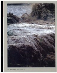
<strong>The</strong> combination <strong>of</strong> heavy rains and melting snow swells the rivers that flow <br />
to the valley floor. From each square mile <strong>of</strong> the watershed, about 40 cubic feet per <br />
second <strong>of</strong> river water flows. At flood, 7,000 cubic feet per second <strong>of</strong> water rushes <br />
down the Cedar <strong>River</strong>, much <strong>of</strong> it absorbed and stored by Lake Washington. But the <br />
Cedar <strong>River</strong>’s flood strength is paltry compared to the 15,000 cubic feet per second <br />
<strong>of</strong> water rushing down the Green <strong>River</strong> before it reaches Auburn, and the White <br />
<strong>River</strong>’s rate <strong>of</strong> 20,000 cubic feet per second. <br />
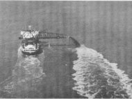
<strong>The</strong> valley floor from Kent north to where the river valley narrows before <br />
reaching Puget Sound is the lowest point in the drainage basin. On that November <br />
day in 1906, waters rising from north <strong>of</strong> Mount Rainier to south <strong>of</strong> Everett rushed to <br />
widen the river at the lowest point on the valley floor to a two‐mil wide torrent 24 <br />
feet deep in places. <br />
<strong>The</strong> water cut <strong>of</strong>f transportation along the Interurban rail line that ran south <br />
from Seattle and Renton to Auburn. Telegraph lines were drowned. Logs and <br />
driftwood rammed into bridges, threatening to sweep them away. <strong>The</strong>y jammed at <br />
the dike built at Neely’s Cut northwest <strong>of</strong> Kent, and when they were dynamited, the <br />
mass swirled downstream with a roar. <br />
“All houses in the valley at <strong>River</strong>ton, Garden Station, Foster, Renton Junction, <br />
Orillia, O’Brien, and Kent are surrounded by water,” observed reporter Robert <br />
Kelsey in the Seattle PostIntelligencer. People fled to higher ground; cows were left <br />
stranded on little islands in the middle <strong>of</strong> rising waters. <br />
“<strong>The</strong> valley has lost all aspects <strong>of</strong> one <strong>of</strong> the riches farming districts in the <br />
state and is as a huge river, with two narrow threads through waste <strong>of</strong> waters, the <br />
Northern Pacific and Interurban railway lines,” he mourned.
Two miles south <strong>of</strong> Kent, the small town <strong>of</strong> Thomas disappeared completely <br />
under water. <br />
By midnight, the rain was falling even harder. <br />
“<strong>The</strong> flood was too unexpected to give us a chance to take precautions,” <br />
explained Board <strong>of</strong> County Commissioners Chairman Charles Baker. “It is now <br />
impossible to do anything in the present condition <strong>of</strong> the valley.” <br />
<strong>The</strong> river overflowed at Auburn and turned Main Street into a small river. <br />
Low‐lying homes like the Hemphill’s house on the north side <strong>of</strong> town were flooded <br />
and Indian Mary’s house was swept away. But Auburn was relatively undamaged, <br />
and farmers from the upper valley to the east began arriving in town seeking safety. <br />
Parts <strong>of</strong> the upper valley were more than 10 feet under water, and the raging <br />
floodwaters swept heavy log booms and driftwood downstream, destroying bridges, <br />
and cutting <strong>of</strong>f roads. At Bloomquist Logging Camp, two loggers drowned while <br />
working to save a raft <strong>of</strong> logs. <br />
Auburn was safe for now, but a mile and a half upstream from where the <br />
White <strong>River</strong> joined forces with the Green <strong>River</strong>, 3 million board feet <strong>of</strong> logs and <br />
driftwood had formed a barrier blocking the north main channel <strong>of</strong> the White. As the <br />
White <strong>River</strong>’s rush <strong>of</strong> water and debris slammed into the drift jam, it began <br />
overflowing and spreading out, spilling into its south channel, the Stuck <strong>River</strong>. <br />
When the White <strong>River</strong> was flowing in its main channel, it wound around the <br />
high gravel bluff formed by the Osceola mudflow that marked the western edge <strong>of</strong> <br />
the Muckleshoot Indian Reservation. <strong>The</strong> White split into two channels flowing <br />
north along the Interurban rail line through Auburn and then became one channel <br />
again near the cemetery and joined the Green <strong>River</strong> at 15 th Street. When overflowing <br />
south into the Stuck <strong>River</strong>, the White <strong>River</strong>’s water continued south to empty into <br />
the Puyallup <strong>River</strong> and onto the tideflats <strong>of</strong> Tacoma’s Commencement Bay, <br />
Which way the White <strong>River</strong> flowed had been an old argument among <br />
neighbors. For 20 years, King County and Pierce County settlers, sometimes armed <br />
with shotguns and dynamite, had changed the channels <strong>of</strong> the White <strong>River</strong> back and <br />
forth to reduce their flood damage at the expense <strong>of</strong> the other. Pierce County <br />
farmers had accused King County <strong>of</strong> dynamiting the gravel bluff on the Muckleshoot <br />
Indian Reservation and changing the course <strong>of</strong> the river southward with a massive <br />
landslide. <br />
King County in 1900 had attempted to make the flow <strong>of</strong> the White <strong>River</strong> into <br />
the Puyallup <strong>River</strong> drainage permanent by erecting an embankment barrier; Pierce <br />
County sued and won an injunction again King County. Later, some King County <br />
farmers extended an olive branch to their neighbors to the south and proposed <br />
equally dividing the flow <strong>of</strong> the White <strong>River</strong> north and south. <br />
King County, however, on that November day in 1906, got rid <strong>of</strong> the White <br />
<strong>River</strong> for good. Seeking a new channel around the drift jam, the White <strong>River</strong> cut
through a narrow strip <strong>of</strong> land separating it form the Stuck <strong>River</strong> and threw its <br />
20,000 cubic feet per second flood flow down the Stuck <strong>River</strong> Valley into the <br />
Puyallup <strong>River</strong>, flooding the valley to Tacoma with a force <strong>of</strong> 33,600 cubic feet per <br />
second. <br />
<strong>The</strong> Puyallup was clocked at slowing 12 miles per hour, overflowing its <br />
banks and flooding its lower valley and the city <strong>of</strong> Tacoma under 6 feet <strong>of</strong> water. It <br />
carried driftwood, lumber, parts <strong>of</strong> houses, and household furniture out into <br />
Commencement Bay. <br />
As the floodwaters receded by year’s end, about 300 property owners and <br />
interested parties in the valley turned out for a flood meeting to discuss various <br />
plans for control <strong>of</strong> the river, “all without acrimony or hard words,” reported the <br />
Auburn Argus. <strong>The</strong> group established a flood committee and commissioned Major <br />
Hiram Chittenden, U.S. Army Corps <strong>of</strong> Engineers, to study the flood problem and <br />
outline remedies. <br />
<strong>The</strong> following May, the major made his report. First <strong>of</strong> all, the White <strong>River</strong> <br />
belonged to King County. <strong>The</strong>re were 20 million cubic yards more river deposit on <br />
the river’s northern flood plain than on its southern course. <strong>The</strong> Stuck <strong>River</strong> Valley <br />
was a low, swampy basin with no evidence <strong>of</strong> a alluvial deposits from the White <br />
<strong>River</strong>, nor was there any evidence <strong>of</strong> a well‐defined channel in the basin from the <br />
White <strong>River</strong>. <strong>The</strong>re had been “a good deal <strong>of</strong> interference by citizens <strong>of</strong> both counties <br />
with natural conditions” <strong>of</strong> the river’s course, leading to major erosion in 1898 <strong>of</strong> a <br />
high bluff on its north bank which slid into the river and shifted its course south. <br />
<strong>The</strong> river regained its former course northward “from natural and artificial causes” <br />
until the flood <strong>of</strong> 1906. <br />
“Whether this last change would, if left alone, be permanent, is idle to <br />
speculate,” the major said. “But the change itself is a most complete one and not a <br />
drop <strong>of</strong> water now flows down the old White <strong>River</strong> channel.” <br />
For the major, the White <strong>River</strong>, although naturally flowing to the Duwamish, <br />
was best left permanently flowing to Tacoma. <strong>The</strong> question for him was whether the <br />
entire White <strong>River</strong> should be carried down the Duwamish Valley or down the <br />
Puyallup Valley, or be divided so that approximately one‐half would flow in each <br />
direction. <br />
As an engineer, he saw a simple answer: “<strong>The</strong> distance to the sea by the <br />
Duwamish route is about 40 miles; that by the Puyallup is only 20 miles. <strong>The</strong> slope <br />
by the shorter route is much greater than by the longer and the same quantity <strong>of</strong> <br />
water can be carried in a smaller channel.” <br />
According to the major, the flooding caused by waters <strong>of</strong> the Black <strong>River</strong> that <br />
drained the Lake Washington and Cedar <strong>River</strong> basins would be eliminated after the <br />
Lake Washington locks and ship canal were built and the lake level was lowered. <br />
That 580‐square mile drainage would be diverted entirely to Lake Washington and <br />
the channel <strong>of</strong> the Black <strong>River</strong> would be abandoned.
<strong>The</strong> major recommended levees or dikes as the cheapest and most effective <br />
way <strong>of</strong> keeping the river in the valley where it should be. Build the side slopes twice <br />
as wide as tall, plant them with a strong turflike Bermuda grass, and keep the banks <br />
bare. “All drift heaps and dense willow or other growth should be removed from the <br />
channel as to leave it free and open,” he advised. <br />
Establish a system <strong>of</strong> policing the river, he recommended, and every summer <br />
burn up drift heaps, cut up trees fallen into the river, and last large stumps so that <br />
the debris will flow down the river when the waters rise in the fall and winter. <br />
With the Black <strong>River</strong> and the White <strong>River</strong>s diverted elsewhere, when dikes <br />
and levees in the valley were build and when the river channels were kept clear <strong>of</strong> <br />
vegetation and driftwood jams, the Duwamish <strong>River</strong> flood stage would only the <br />
15,300 cubic feet per second flow <strong>of</strong> the Green <strong>River</strong> to carry. <br />
In fact, the stretch <strong>of</strong> river from Auburn to Tukwila would no longer be called <br />
the White <strong>River</strong> but the Green <strong>River</strong>, and the valley <strong>of</strong> its meander would be the <br />
Green <strong>River</strong> Valley from Auburn north to the southern edge <strong>of</strong> Seattle’s Duwamish <br />
<strong>River</strong> Valley. <br />
As for the Duwamish, its dredging and rechanneling would begin in a few <br />
short years, and the silt from the river once deposited on its delta would move <br />
swiftly into the bay. <br />
“<strong>The</strong> interference <strong>of</strong> man with these processes is wholly in the line <strong>of</strong> <br />
arresting overflow,” the major proclaimed. “When this has been fully accomplished <br />
and all the sediment is forced out into tide water, delta extension will be accelerated <br />
and land building in the valley will cease altogether.” <br />
<strong>The</strong> Green <strong>River</strong> proved that the major was wrong. Giving the White <strong>River</strong> to <br />
Tacoma, sending Lake Washington and the Cedar <strong>River</strong> out through the Chittenden <br />
Locks in 1916, and starting the rechanneling <strong>of</strong> the Duwamish <strong>River</strong> in 1912 wasn’t <br />
enough to tame the river. Almost every two years, the Green <strong>River</strong>, now reduced to <br />
draining ony a 474‐square=mile watershed, flooded the farmland and residences <br />
form Auburn to Kent to Orillia, Allentown, and South Park. <br />
<strong>The</strong> floods <strong>of</strong> 1917, 1933, and 1946 were especially severe, with the water in <br />
1933 putting Orillia and Renton under almost 10 feet <strong>of</strong> water. In all, 11,600 acres <strong>of</strong> <br />
valley farmland were flooded, and damage was estimated at $1.75 million for 1933. <br />
In 1946, 12,000 acres were flooded at a loss <strong>of</strong> $1.3 million. <br />
Proposed solutions abounded. By the 1930s, the talk was definitely centered <br />
on building a reservoir to hold the winter storm waters <strong>of</strong> the Green <strong>River</strong>. Earlier, <br />
Seattle engineers had proposed and abandoned digging a canal from Kent to Lake <br />
Washington to divert the flow and floods <strong>of</strong> the Green <strong>River</strong>. A proposal to divert the <br />
winter flow <strong>of</strong> the Green <strong>River</strong> to the Cedar <strong>River</strong> unfortunately would make the <br />
Cedar <strong>River</strong> Valley a floodway. Constructing a two‐mile tunnel from Kent to Puget <br />
Sound to drain the river and the valley was definitely too expensive. Building up the
levees farmers had placed north <strong>of</strong> Kent around the turn <strong>of</strong> the century and diking <br />
the rest <strong>of</strong> the valley to handle a flood like that <strong>of</strong> 1906 would require a channel and <br />
right‐<strong>of</strong>‐way 700 feet wide and dikes 20 feet high at a cost <strong>of</strong> $24 million. <br />
<strong>The</strong> most reasonable solution, then, was a reservoir created by a dam on the <br />
river, and its advocate for the next 25 years was Colonel Howard Hanson, King <br />
County chief civil deputy attorney and chairman <strong>of</strong> the Seattle Chamber <strong>of</strong> <br />
Commerce’s <strong>River</strong>s and Harbors Subcommittee. <br />
“Whether it be for a home, a city, or an expanded metropolitan area, there <br />
must be a site, a locale, suited to the purpose by nature or made so by man’s efforts,” <br />
wrote Hanson in the 1957 Pacific Northwest Quarterly article, “More Land For <br />
Industry.” <br />
With a dam built and the Duwamish waterway extended to Tukwila, Hanson <br />
believed that “Old Man <strong>River</strong>, from Elliott Bay to Auburn, will be under control and <br />
the entire valley available for its highest and best use.” <br />
<strong>The</strong> major vision and the colonel’s perseverance were the driving forces that <br />
would tame the river to serve its people. And when it was tamed, the face <strong>of</strong> its <br />
waters, the land <strong>of</strong> its valleys, and the hearts <strong>of</strong> its people were changed in a way <br />
that the major and the colonel could scarcely have imagined. <br />
‐end‐