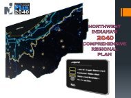
Comprehensive Regional Plan - Northwestern Indiana Regional ...
Comprehensive Regional Plan - Northwestern Indiana Regional ...
Comprehensive Regional Plan - Northwestern Indiana Regional ...

You also want an ePaper? Increase the reach of your titles
YUMPU automatically turns print PDFs into web optimized ePapers that Google loves.
Hammond<br />
Munster<br />
Dyer<br />
Whiting<br />
East Chicago<br />
St. John<br />
Highland<br />
Schererville<br />
Griffith<br />
Cedar Lake<br />
Schneider<br />
Lake Dalecarlia<br />
Lowell<br />
Gary<br />
Merrillville<br />
Crown Point<br />
Lake Michigan<br />
New Chicago<br />
Hobart<br />
Lake Station<br />
Winfield<br />
Lakes of the Four Seasons<br />
Ogden Dunes<br />
Hebron<br />
Portage<br />
Dune Acres<br />
Porter<br />
Chesterton<br />
Valparaiso<br />
Kouts<br />
Beverly Shores<br />
Pines<br />
Westville<br />
Michigan City<br />
Wanatah<br />
La Crosse<br />
Long Beach<br />
Pottawattamie Park<br />
Trail Creek<br />
Michiana Shores<br />
La Porte<br />
Kingsbury<br />
Kingsford Heights<br />
¬«41<br />
Creating Tomorrow Today Subregional Cluster Workshops:<br />
Corridors Synthesis<br />
¬« 212<br />
®q<br />
¬« 520<br />
¬«12<br />
§¨¦ ¬« I-94<br />
912 [l<br />
¬«20<br />
®q<br />
¬« §¨¦ 249 ¬« 152 I-90<br />
¬« 312 ¬« 421<br />
¬«2<br />
®q<br />
§¨¦<br />
§¨¦ I-90<br />
I-94 ®q<br />
¬«55<br />
®q<br />
¬«51<br />
¬«2<br />
¬«35<br />
¬«2<br />
®q<br />
¬«55<br />
¬«41<br />
§¨¦ I-80 ¬«30<br />
¬«55<br />
¬« 149<br />
§¨¦ I-80<br />
¬« 130 ¬«2<br />
¬« 231 ¬«49<br />
§¨¦ I-65<br />
¬«8<br />
¬«35<br />
®q ®q<br />
¬« 421<br />
¬«35<br />
¬«20<br />
¬«4<br />
¬« 104<br />
¬«6<br />
¬«39<br />
Corridor Types and Levels of Consensus<br />
Expressway<br />
Weak Consensus<br />
Arterial<br />
Medium Consensus<br />
Heavy Rail<br />
Strong Consensus<br />
Light Rail<br />
Bus Rapid Transit<br />
Water<br />
Proposed New Road<br />
Trails<br />
Corridor Studies<br />
Weak Consensus<br />
Corridor studies are a key<br />
planning activity undertaken by<br />
NIRPC. Corridor studies usually<br />
coordinate transportation and<br />
land use activities along a major<br />
transportation link, such as a<br />
state highway or transit corridor,<br />
toward the development of a<br />
comprehensive vision for that<br />
proposed corridor.<br />
Medium Consensus<br />
Strong Consensus<br />
<strong>Regional</strong>ly significant multimodal<br />
corridors identified for the 2040 CRP<br />
Proposed consolidation<br />
into a larger center<br />
µScale 1 : 80,000<br />
<strong>Northwestern</strong> <strong>Indiana</strong> <strong>Regional</strong> <strong>Plan</strong>ning Commission<br />
1<br />
0 2 4 6 8 10<br />
Miles<br />
2040 <strong>Comprehensive</strong> <strong>Regional</strong> <strong>Plan</strong><br />
Map produced by <strong>Northwestern</strong> <strong>Indiana</strong> <strong>Regional</strong> <strong>Plan</strong>ning Commission (NIRPC). NIRPC<br />
cannot be held liable for any errors or inaccuracies in the information provided in this map.<br />
21<br />
Figure 14 – US-20 Five-Lane with Two-Way Left Turn Lane<br />
Image from the 2008 NIRPC Porter<br />
County U.S. 12/20 Transportation<br />
Corridor <strong>Plan</strong><br />
The Porter County U.S. 12/20 Transportation Corridor <strong>Plan</strong><br />
A-NIRPC0701.00<br />
Northwest <strong>Indiana</strong> <strong>Regional</strong> <strong>Plan</strong>ning Commission Page 36