Islington's Transport Strategy and Local ... - Islington Council
Islington's Transport Strategy and Local ... - Islington Council
Islington's Transport Strategy and Local ... - Islington Council

You also want an ePaper? Increase the reach of your titles
YUMPU automatically turns print PDFs into web optimized ePapers that Google loves.
<strong>Islington</strong>’s <strong>Transport</strong> <strong>Strategy</strong> <strong>Local</strong> Implementation Plan 2011 to 2031<br />
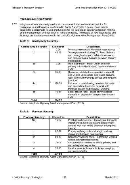
Road network classification<br />
2.57 <strong>Islington</strong>’s streets are designated in accordance with national codes of practice for<br />
carriageways <strong>and</strong> footways, as detailed in Table 7 <strong>and</strong> Table 8 below. Each road is<br />
designated according to its use <strong>and</strong> function for the purpose of informing decision-making<br />
on the management <strong>and</strong> operation of <strong>Islington</strong>’s roads. The details of how these roads <strong>and</strong><br />
footways are treated are set out in the council’s Highway Asset Management Plan (2010).<br />
Table 7:<br />
Carriageway hierarchy<br />
Carriageway hierarchy Kilometres Description<br />
1 0.00 Motorway (subject to Motorway regulations)<br />
2 40.13 Strategic route (including TfL Road Network<br />
<strong>and</strong> borough principal roads) – trunk roads<br />
<strong>and</strong> some principal A roads between primary<br />
destinations<br />
3a 9.25 Main distributor – major urban <strong>and</strong> inter<br />
primary links with short <strong>and</strong> medium distance<br />
traffic<br />
3b 35.38 Secondary distributor – classified routes (B<br />
<strong>and</strong> C) <strong>and</strong> unclassified bus routes carrying<br />
local traffic with frontage access <strong>and</strong> frequent<br />
junctions<br />
4a 190.51 Link road – roads linking between the main<br />
<strong>and</strong> secondary distributor network with<br />
frontage access <strong>and</strong> frequent junctions<br />
4b 19.44 <strong>Local</strong> access road – roads serving limited<br />
numbers of properties, carrying only access<br />
traffic<br />
Total 294.72<br />
Source: <strong>Islington</strong>’s Highway Asset Management Plan (2010)<br />
Table 8:<br />
Footway hierarchy<br />
Footway hierarchy Kilometres Description<br />
1(a) 16.22 Prestige walking zone – footways at transport<br />
interchanges, high streets <strong>and</strong> employment<br />
centres with high levels of footfall throughout<br />
the day<br />
1 62.84 Primary walking route – strategic walking<br />
routes <strong>and</strong> between destinations<br />
2 89.38 Secondary walking route – alternative walking<br />
routes between destinations<br />
3 384.6 Link footways – footways linking primary <strong>and</strong><br />
secondary walking routes<br />
4 38.88 <strong>Local</strong> access footways – footways carrying<br />
only access traffic<br />
Total 591.92<br />
Source: <strong>Islington</strong>’s Highway Asset Management Plan (2010)<br />
London Borough of <strong>Islington</strong> 27 March 2012