How a visit to Killhope can inspire
How a visit to Killhope can inspire
How a visit to Killhope can inspire

You also want an ePaper? Increase the reach of your titles
YUMPU automatically turns print PDFs into web optimized ePapers that Google loves.
UNIT 18: WHAT WAS IT LIKE TO LIVE HERE IN THE PAST?<br />
Using <strong>Killhope</strong>: The QCA standards recommend focussing on one aspect of the local community<br />
in the locality, which might also be part of a field trip. <strong>Killhope</strong> is excellent in this respect as it offers<br />
the opportunity <strong>to</strong> see how the area has changed since Vic<strong>to</strong>rian times, which were well<br />
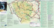
documented. Vic<strong>to</strong>rian maps of the area <strong>can</strong> be supplied on request. The site <strong>can</strong> then be<br />
compared <strong>to</strong> its use in the present day, when the landscape has changed and roads and bridges<br />
have been built. The site in its current form has only existed since the 1980s, when it was<br />
excavated.<br />
Our Resource boxes offer excellent classroom support for this unit. For more information on them,<br />
please see the section in this pack.<br />
LEARNING OBJECTIVES POSSIBLE ACTIVITIES LEARNING OUTCOMES<br />
• That a map is a<br />
representation of the area.<br />
• To recognise some<br />
features in the local area,<br />
and <strong>to</strong> locate them on a<br />
map.<br />
• That an area may contain<br />
a mixture of old and new<br />
buildings.<br />
What is our area like <strong>to</strong>day?<br />
• Prepare a simplified map of the<br />
area, with <strong>Killhope</strong> marked as its<br />
central point, and ask the<br />
children what they know about<br />
the area.<br />
• Use the pictures as a basis for<br />
an introduc<strong>to</strong>ry discussion about<br />
the age of the site and who uses<br />
it. Sort it in<strong>to</strong> old and new, with<br />
reasons, and use this <strong>to</strong> discuss<br />
the concept of ‘old’.<br />
<strong>How</strong> <strong>can</strong> we use maps <strong>to</strong> explore how our area has changed?<br />
• Identify features in<br />
their area on a large<br />
map.<br />
• Use features of<br />
buildings <strong>to</strong> infer their<br />
use and who owned<br />
them,<br />
• Categorise buildings<br />
as ‘old’ or ‘new’.<br />
• That the area has changed<br />
at different times in the<br />
past.<br />
• To sequence maps in<br />
chronological order.<br />
• To use maps <strong>to</strong> help<br />
describe some of the<br />
characteristic features of<br />
the past.<br />
• Divide the children in<strong>to</strong> small<br />
groups and give them an old and<br />
a new map of <strong>Killhope</strong>. We have<br />
modern maps, nineteenth<br />
century maps, and maps from<br />
before <strong>Killhope</strong> was excavated.<br />
Ask them <strong>to</strong> look for and record<br />
changes by comparing the two<br />
maps.<br />
• Help the children build up a<br />
picture of the past by choosing<br />
two points on the map and<br />
asking children <strong>to</strong> describe what<br />
it was like using as many senses<br />
as possible.<br />
• Record changes<br />
shown on maps in<br />
table form.<br />
• Contribute <strong>to</strong> making a<br />
visual timeline.<br />
• Produce a description<br />
of the area that<br />
contains appropriate<br />
his<strong>to</strong>rical detail.<br />
26