How a visit to Killhope can inspire
How a visit to Killhope can inspire
How a visit to Killhope can inspire

Create successful ePaper yourself
Turn your PDF publications into a flip-book with our unique Google optimized e-Paper software.
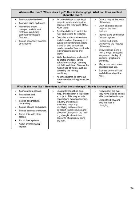
Where is the river? Where does it go? <strong>How</strong> is it changing? What do I think and feel<br />
about the river?<br />
• To undertake fieldwork.<br />
• To make plans and maps.<br />
• <strong>How</strong> rivers erode,<br />
transport and deposit<br />
materials producing<br />
particular landscape<br />
features.<br />
• To use secondary sources<br />
of evidence.<br />
• Ask the children <strong>to</strong> use local<br />
maps <strong>to</strong> locate and map the<br />
course of the tributaries of the<br />
River Wear.<br />
• Ask the children <strong>to</strong> sketch the<br />
river and record its features.<br />
• Describe and explain erosion<br />
and deposition, focusing on a<br />
suitable meander point (there<br />
is one on site) <strong>to</strong> contrast<br />
bends, speed of flow, contrasts<br />
in riverbank features and<br />
depth.<br />
• Walk the riverbank and note if<br />
its profile changes, taking<br />
suitable recordings, carrying<br />
out field sketches. Discuss the<br />
human use of water, such as<br />
powering the mining<br />
machinery.<br />
• Ask the children <strong>to</strong> carry out<br />
some creative writing about the<br />
river.<br />
• Draw a map of the route<br />
of the river.<br />
• Draw and label sketch<br />
maps of the river<br />
features.<br />
• Identify parts of the river<br />
/ stream system.<br />
• Record and graph<br />
changes <strong>to</strong> the features<br />
of the river.<br />
• Show change along a<br />
river’s length through a<br />
sequenced display of<br />
sections, graphs and<br />
sketches.<br />
• Map a river section and<br />
annotate land use.<br />
• Express personal likes<br />
and dislikes about the<br />
river.<br />
What is the river like? <strong>How</strong> does it affect the landscape? <strong>How</strong> is it changing and why?<br />
• To investigate places.<br />
• To analyse and<br />
communicate.<br />
• To use geographical<br />
vocabulary.<br />
• To use atlases and globes.<br />
• To use secondary sources.<br />
• About links with other<br />
places.<br />
• About river systems.<br />
• About environmental<br />
impact.<br />
• Locate <strong>Killhope</strong> Burn on a<br />
map, and research it <strong>to</strong> present<br />
a project. This may include:<br />
connections between farming,<br />
industry and climate;<br />
annotated maps e.g.<br />
identifying settlements or<br />
transport routes; causes and<br />
effects of changes in the river<br />
e.g. drought; descriptive<br />
accounts of a journey along<br />
the river.<br />
• Know about the river<br />
they have studied and its<br />
effect on the landscape.<br />
• Understand how and<br />
why the river is<br />
changing.<br />
34