How a visit to Killhope can inspire
How a visit to Killhope can inspire
How a visit to Killhope can inspire

Create successful ePaper yourself
Turn your PDF publications into a flip-book with our unique Google optimized e-Paper software.
• About physical and<br />
human features.<br />
• About land use in<br />
settlements.<br />
• To use and interpret<br />
maps.<br />
• To use secondary<br />
sources.<br />
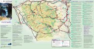
What is <strong>Killhope</strong> like?<br />
• Help the children <strong>to</strong> match<br />
ground pho<strong>to</strong>graphs of the main<br />
human and physical features <strong>to</strong><br />
a base map of <strong>Killhope</strong>, naming<br />
features and listing questions for<br />
further research.<br />
• Study aerial pho<strong>to</strong>graphs of<br />
<strong>Killhope</strong>. Use suitable<br />
vocabulary <strong>to</strong> identify land use<br />
and features and label an outline<br />
plan showing key land use<br />
boundaries.<br />
• Discuss the layout of <strong>Killhope</strong><br />
and reasons for why it is like it is.<br />
• Identify main human and<br />
physical features of<br />
<strong>Killhope</strong>.<br />
• Develop an awareness<br />
and understanding of land<br />
use at <strong>Killhope</strong>.<br />
What are the main land uses at <strong>Killhope</strong>?<br />
• To collect evidence.<br />
• To use fieldwork<br />
techniques.<br />
• About physical and<br />
human features.<br />
• To use land use in<br />
settlements.<br />
• Discuss how land use <strong>can</strong> be<br />
recorded.<br />
• At <strong>Killhope</strong>, divide the children<br />
in<strong>to</strong> pairs and ask each pair <strong>to</strong><br />
identify a land use, eg houses,<br />
roads etc and mark it on a<br />
colour-coded base map.<br />
• Identify and understand<br />
different land uses.<br />
• Record land use on a<br />
map using a key.<br />
What jobs do people do? <strong>How</strong> do they get <strong>to</strong> work? What services do nearby settlements<br />
provide?<br />
• To collect and record<br />
evidence.<br />
• About how the locality is<br />
linked <strong>to</strong> other places.<br />
• To use and interpret<br />
maps.<br />
• With the children, design and<br />
conduct a survey <strong>to</strong> identify jobs<br />
around the site, then and now.<br />
List the jobs and ask the children<br />
<strong>to</strong> categorise them and<br />
investigate how far people<br />
travelled <strong>to</strong> work then, and how<br />
far they travel now.<br />
• Ask the children <strong>to</strong> use OS maps<br />
<strong>to</strong> list 3 or 4 nearby <strong>to</strong>wns<br />
people could use <strong>to</strong> obtain<br />
certain goods eg clothes. Ask<br />
the children <strong>to</strong> map a route <strong>to</strong><br />
these places, and describe it.<br />
• Classify types of work.<br />
• Understand the<br />
relationship between<br />
work and travel.<br />
• Describe a journey,<br />
including the route and<br />
type of transport.<br />
• Draw a simple map <strong>to</strong><br />
show a route.<br />
30