Bengalla Mining Company Pty Limited - Rio Tinto Coal Australia
Bengalla Mining Company Pty Limited - Rio Tinto Coal Australia
Bengalla Mining Company Pty Limited - Rio Tinto Coal Australia

You also want an ePaper? Increase the reach of your titles
YUMPU automatically turns print PDFs into web optimized ePapers that Google loves.
<strong>Bengalla</strong> <strong>Mining</strong> <strong>Company</strong> <strong>Pty</strong> <strong>Limited</strong><br />
Rehabilitation & Landscape<br />
Management Plan<br />
Revision Date Description Author Reviewer Approved<br />
0 16/07/07 Original Document<br />
M Walker<br />
Hansen Bailey<br />
D Munro<br />
Hansen Bailey<br />
J Torkington<br />
<strong>Bengalla</strong> Mine<br />
1 25/10/07<br />
Revision<br />
incorporating<br />
comments from<br />
DPI<br />
M Walker<br />
Hansen Bailey<br />
D Munro<br />
Hansen Bailey<br />
J Torkington<br />
<strong>Bengalla</strong> Mine
Rehabilitation & Landscape<br />
Management Plan<br />
TABLE OF CONTENTS<br />
1.0 BACKGROUND ...........................................................................1<br />
1.1 Introduction ................................................................................ 1<br />
1.2 Management Plan Requirement ...................................................... 1<br />
1.3 Management Plan Objective........................................................... 3<br />
1.4 Document Structure ..................................................................... 4<br />
2.0 ENVIRONMENTAL MANAGEMENT SYSTEM..................................5<br />
3.0 REHABILITATION MANAGEMENT PLAN .....................................7<br />
3.1 Objectives................................................................................... 7<br />
3.2 Five Year Rehabilitation and Management Measures ........................ 10<br />
3.3 Medium and Long-term Management Measures .............................. 14<br />
3.4 Completion Criteria .................................................................... 14<br />
4.0 FINAL VOID MANAGEMENT PLAN ............................................18<br />
4.1 Justification............................................................................... 18<br />
4.2 Design Criteria........................................................................... 19<br />
4.3 Actions & Control Measures ......................................................... 19<br />
5.0 MINE CLOSURE PLAN ..............................................................20<br />
5.1 Objectives................................................................................. 20<br />
5.2 Post-<strong>Mining</strong> Land Use Options...................................................... 20<br />
5.3 Mine Infrastructure .................................................................... 22<br />
5.4 Environmental Management ........................................................ 22<br />
5.5 Performance Measurement .......................................................... 22<br />
6.0 STAKEHOLDER CONSULTATION...............................................23<br />
7.0 REPORTING & REVIEW............................................................23<br />
8.0 RESPONSIBILITIES .................................................................24<br />
9.0 REFERENCES ...........................................................................25<br />
Ref: 071025 bmc rehabilitation & landscape mp<br />
Page ii
Rehabilitation & Landscape<br />
Management Plan<br />
LIST OF TABLES<br />
Table 1 Rehabilitation and Landscape Management Plan Requirements ............. 2<br />
Table 2 EMS Standards and Procedures ........................................................ 5<br />
Table 3 Comparison of Pre-<strong>Mining</strong> and Post-<strong>Mining</strong> Land Capability .................. 7<br />
Table 4 <strong>Bengalla</strong> Initial Rehabilitation Completion Criteria ............................. 15<br />
Table 5 Management Measures and Responsibilities ..................................... 24<br />
Table 6 Indicative Vegetation Species Directly Seeded at <strong>Bengalla</strong> ................. 52<br />
LIST OF FIGURES<br />
Figure 1 Conceptual Post-<strong>Mining</strong> Landform..................................................... 8<br />
Figure 2 Conceptual Post-<strong>Mining</strong> Land Capability............................................. 9<br />
LIST OF APPENDICES<br />
Appendix A<br />
Appendix B<br />
Appendix C<br />
Regulatory Correspondence<br />
Relevant CNA EMS Procedures<br />
Typical Revegetation Species Mix<br />
Ref: 071025 bmc rehabilitation & landscape mp<br />
Page iii
Rehabilitation & Landscape<br />
Management Plan<br />
1.0 Background<br />
1.1 Introduction<br />
<strong>Bengalla</strong> Mine (<strong>Bengalla</strong>) is located approximately 4 kilometres (km) west of<br />
Muswellbrook in the Upper Hunter Valley of New South Wales (NSW).<br />
<strong>Bengalla</strong> <strong>Mining</strong> <strong>Company</strong> (BMC) was granted development consent (DA 211/93) in 1996<br />
under the Environmental Planning and Assessment Act 1979 (EP&A Act) to operate<br />
<strong>Bengalla</strong>, in accordance with the supporting document <strong>Bengalla</strong> Mine Environmental<br />
Impact Statement 1993 (<strong>Bengalla</strong> EIS). This approval allowed <strong>Bengalla</strong> to produce up to<br />
8.7 Million tonnes per annum (Mtpa) of Run-of-mine (ROM) coal to 2017, and conduct<br />
other associated mining activities.<br />
BMC was granted a modification to DA 211/93 (DA 211/93 (M1)) under Section 96(2) of<br />
the EP&A Act in November 2006 in accordance with the supporting document Statement<br />
of Environmental Effects – Modifications to <strong>Mining</strong> Operations 2006 (<strong>Bengalla</strong> SEE). This<br />
modification permits BMC to:<br />
• Increase the final landform height to 270 Reduced Level (RL);<br />
• Relocate the overland conveyor and ROM <strong>Coal</strong> Hopper;<br />
• Upgrade the <strong>Coal</strong> Handling and Preparation Plant (CHPP) to allow two-stage<br />
washing;<br />
• Construct temporary tailings drying areas; and<br />
• Increase maximum allowable ROM coal production levels to 10.7 Mtpa.<br />
1.2 Management Plan Requirement<br />
This Rehabilitation and Landscape Management Plan (RLMP) has been prepared in<br />
consultation with the Department of Primary Industries (DPI) and to the satisfaction of<br />
the Department of Planning (DoP). The appointment of Hansen Bailey (Environmental<br />
Consultants) to prepare this RLMP has been approved by DoP prior to commencement.<br />
Correspondence with DPI and DoP is provided in Appendix A.<br />
This RLMP has been developed in accordance with the requirements of DA 211/93 (M1)<br />
Schedule 3, Conditions 33, 34, 35 and 36 which are listed in Table 1. A reference to<br />
where each specific requirement is addressed in this RLMP is also included.<br />
Ref: 071025 bmc rehabilitation & landscape mp Page 1
Rehabilitation & Landscape<br />
Management Plan<br />
Table 1<br />
Rehabilitation & Landscape Management Plan Requirements<br />
Condition Requirement Section<br />
33<br />
By end of July 2007, the Applicant must prepare (and following approval<br />
implement) a detailed Rehabilitation and Landscape Management Plan<br />
for the development, in consultation with affected agencies, and to the<br />
satisfaction of the DPI and the Director-General. This plan must be<br />
prepared by suitably qualified expert/s whose appointment/s have been<br />
approved by the Director-General, and must include a:<br />
(a)<br />
Rehabilitation Management Plan;<br />
This<br />
RLMP<br />
(b)<br />
(c)<br />
Final Void Management Plan; and<br />
Mine Closure Plan.<br />
34<br />
The Rehabilitation Management Plan must include:<br />
(a) the rehabilitation objectives for the site; 3.1<br />
(b)<br />
(c)<br />
(d)<br />
(e)<br />
a description of the short, medium, and long term measures that<br />
would be implemented to:<br />
• rehabilitate the site; and<br />
• manage the remnant vegetation and habitat on the site;<br />
detailed assessment and completion criteria for the rehabilitation<br />
of the site;<br />
a detailed description of how the performance of the rehabilitation<br />
of the mine would be monitored over time to achieve the stated<br />
objectives;<br />
a detailed description of what measures would be implemented<br />
over the next 5 years to rehabilitate and manage the landscape of<br />
the site including the procedures to be implemented for:<br />
3.2 &<br />
3.3<br />
3.4<br />
3.2.5 &<br />
4.0<br />
3.2<br />
• progressively rehabilitating areas disturbed by mining; 3.2.3 &<br />
3.2.4<br />
• implementing revegetation and regeneration; 3.2.4<br />
• protecting areas outside the disturbance areas; 3.2.1<br />
• managing impacts on fauna; 3.2.1<br />
• conserving and reusing topsoil; 3.2.1 &<br />
3.2.3<br />
• collecting and propagating seed for rehabilitation works; 3.2.1<br />
• salvaging and reusing material from the site for habitat<br />
enhancement;<br />
3.2.1<br />
• controlling weeds and feral pests; 3.2.6<br />
• controlling access; 3.2.5<br />
• bushfire management; 3.2.6<br />
• managing any identified conflicts between the rehabilitation of<br />
the mine and Aboriginal cultural heritage; and<br />
3.2.1<br />
Ref: 071025 bmc rehabilitation & landscape mp Page 2
Rehabilitation & Landscape<br />
Management Plan<br />
Condition Requirement Section<br />
(f)<br />
details of who is responsible for monitoring, reviewing, and<br />
implementing the plan.<br />
6.0<br />
The Final Void Management Plan must: 4.0<br />
(a) justify the planned final location and future use of the final void/s; 4.1<br />
35<br />
(b)<br />
incorporate design criteria and specifications for the final void/s<br />
based on verified groundwater modelling predictions and a reassessment<br />
of post-mining groundwater equilibration; and<br />
(c) describe what actions and measures would be implemented to: 4.3<br />
4.2<br />
• minimise any potential adverse impacts associated with the<br />
final void/s; and<br />
• manage and monitor the potential impacts of the final void/s<br />
until the <strong>Mining</strong> Lease for the development is relinquished.<br />
The Mine Closure Plan must: 5.0<br />
a) define the objectives and criteria for mine closure; 5.1<br />
36<br />
b) investigate options for the future use of the site, including any<br />
final void/s;<br />
c) describe the measures that would be implemented to minimise or<br />
manage the ongoing environmental effects of the development;<br />
and<br />
d) describe how the performance of these measures would be<br />
monitored over time.<br />
5.2<br />
5.4<br />
5.5<br />
This RLMP has been compiled generally in accordance with the Strategic Framework for<br />
Mine Closure (ANZMEC/MCA, 2000), Guidelines to <strong>Mining</strong>, Rehabilitation and<br />
Environmental Management Process (DPI, 2006) and <strong>Bengalla</strong>’s <strong>Mining</strong> Operations Plan<br />
(MOP) (2006).<br />
1.3 Management Plan Objective<br />
The primary objective of this RLMP is to address the requirements of DA 211/93 (M1)<br />
and to plan for rehabilitation and mine closure at <strong>Bengalla</strong> to satisfy regulatory and <strong>Rio</strong><br />
<strong>Tinto</strong> <strong>Coal</strong> <strong>Australia</strong> (RTCA) requirements.<br />
This RLMP includes preliminary details of the Final Void Management Plan and Mine<br />
Closure Plan based on existing and available information. This is consistent with the<br />
explanatory note included in Development Consent Condition 33 (Table 1) which allows<br />
for the subsequent revision of this RLMP to include a detailed Final Void Management<br />
Plan and Mine Closure Plan. As mining at <strong>Bengalla</strong> is currently planned and approved to<br />
continue for at least 10 years, a detailed Final Void Management Plan and Mine Closure<br />
Plan will be developed at least five years prior to mine closure.<br />
Ref: 071025 bmc rehabilitation & landscape mp Page 3
Rehabilitation & Landscape<br />
Management Plan<br />
Two options are currently available at <strong>Bengalla</strong> in regards to mine planning and ultimate<br />
mine closure. The first option is as currently approved, mine closure in 2017, with a final<br />
void located to the west. The second option relates to large areas of identified coal<br />
reserves to the west of currently approved mining operations at <strong>Bengalla</strong>. Should<br />
<strong>Bengalla</strong> seek and be granted approval to continue mining to uncover these coal<br />
reserves, then mine closure would be rescheduled and the final location of the final void<br />
would be altered.<br />
1.4 Document Structure<br />
This RLMP is structured as follows:<br />
• Section 2.0 describes <strong>Bengalla</strong>’s Environmental Management System (EMS) with<br />
particular reference to rehabilitation and mine closure aspects;<br />
• Section 3.0 provides <strong>Bengalla</strong>’s Rehabilitation Management Plan, describing:<br />
o The overall objective for rehabilitation;<br />
o The rehabilitation and management measures to be implemented over the<br />
next five years;<br />
o The ongoing medium and long-term rehabilitation and management measures<br />
to be implemented, beyond the five year period of this RLMP; and<br />
o The completion criteria, success indicators and performance monitoring<br />
techniques to measure the success of rehabilitation.<br />
• Section 4.0 provides the preliminary Final Void Management Plan based on<br />
information available to date, including:<br />
o A justification for the final void design and location;<br />
o A conceptual design criteria for the final void, utilising preliminary information<br />
and the results of a recent groundwater assessment; and<br />
o Conceptually describing the actions and control measures required for the<br />
final void.<br />
• Section 5.0 presents the preliminary Mine Closure Plan, including a preliminary<br />
discussion on:<br />
o The preliminary overall objectives for mine closure;<br />
o The potential post mining land use for the mine site;<br />
o The conceptual design criteria for mine closure, with reference to those items<br />
which are anticipated to be removed or retained;<br />
o The conceptual environmental management and monitoring network after<br />
mine closure; and<br />
o The conceptual measures for evaluating performance after mine closure.<br />
• Section 6.0 describes the stakeholder consultation undertaken in relation to<br />
rehabilitation and mine closure to date;<br />
• Section 7.0 outlines the reporting and review requirements of this RLMP; and<br />
• Section 8.0 lists actions and key responsibilities associated with this RLMP.<br />
Ref: 071025 bmc rehabilitation & landscape mp Page 4
Rehabilitation & Landscape<br />
Management Plan<br />
2.0 Environmental Management System<br />
BMC has in place an EMS accredited to the International Standards Organisation (ISO)<br />
14001 standard. The EMS is designed so that BMC can:<br />
• Effectively manage its environmental issues;<br />
• Ensure compliance with regulatory requirements;<br />
• Continually improve its environmental performance; and<br />
• Satisfy the expectations of stakeholders and the local community.<br />
The EMS forms the basis of environmental management at <strong>Bengalla</strong> and includes a<br />
procedures, standards and management plans to ensure all regulatory requirements are<br />
met. This RLMP (and any subsequent revisions) will form part of the EMS.<br />
Table 2 lists the standards and procedures associated with the EMS and highlights those<br />
specifically relevant to rehabilitation, final void and mine closure (which are reproduced<br />
in Appendix B).<br />
Table 2<br />
EMS Standards & Procedures<br />
1. EMS<br />
Standard<br />
2. Environmental, Social<br />
and Cultural Impact<br />
Management<br />
Procedures<br />
1.1 Aspects and Impacts<br />
1.2 Objectives and Targets<br />
1.3 Risk Assessments<br />
1.4 Environmental Audits, Inspections and Non-Conformance<br />
Management (includes regulatory audits)<br />
1.5 Environmental Legislative Compliance<br />
1.6 Environmental Training<br />
1.7 Environmental Reporting<br />
1.8 Incident Reporting<br />
1.9 Communications (includes community and complaints<br />
management)<br />
1.10 Monitoring and Measurement*<br />
1.11 Annual Management Review of the EMS<br />
1.12 Document Control<br />
2.1<br />
Cultural Heritage Management (includes European and<br />
Aboriginal heritage)*<br />
3. Property Transaction 3.1 Property Transaction Guidelines (<strong>Rio</strong> <strong>Tinto</strong>)*<br />
4. Closure Planning 4.1 Closure Planning Guidelines*<br />
5. Rehabilitation 5.1 Rehabilitation*<br />
6. Waste Management<br />
6.1 Waste Management (includes hazardous and Group A waste)<br />
6.2 Coarse Rejects and Tailings Disposal<br />
Ref: 071025 bmc rehabilitation & landscape mp Page 5
Rehabilitation & Landscape<br />
Management Plan<br />
Standard<br />
7. Water Management<br />
Procedures<br />
7.1 Water Management*<br />
7.2 Water Discharge*<br />
8.1 Dust Management CHPP<br />
8. Air Quality Management 8.2 Air Quality – Mobile Equipment<br />
8.3 Air Quality – Spontaneous Combustion<br />
9. Noise and Vibration 9.1 Noise<br />
Control 9.2 Blasting (includes air quality and vibration)<br />
10. Land Management<br />
11. Greenhouse<br />
Minimisation<br />
10.1<br />
Visual Management (including infrastructure design and<br />
lighting management)*<br />
10.2 Flora and Fauna*<br />
11.1 Greenhouse Minimisation<br />
12. Acid Mine Drainage 12.1 Acid Mine Drainage Prevention and Control*<br />
13. Site Contamination<br />
Prevention and Control<br />
13.1<br />
Site Contamination Prevention and Controls (note: Safety<br />
System handles chemicals)<br />
*denotes procedures specifically relevant to rehabilitation and mine closure<br />
The EMS requires that objectives and targets be established to ensure continual<br />
improvement in environmental performance. The EMS also contains Environmental<br />
Management Programs (EMPs) which document the practical means to achieve objectives<br />
and targets and continually reduce environmental risks through identified environmental<br />
improvements.<br />
The EMS includes a variety of environmental audits to be undertaken at <strong>Bengalla</strong><br />
including:<br />
• Regular internal, independent environmental audits which are undertaken four<br />
times per year;<br />
• Periodic external certification audits of the EMS to verify it complies with ISO14001<br />
undertaken biennially;<br />
• A combined biennial compliance audit of approval conditions and RTCA<br />
expectations;<br />
• DoP audits at five yearly intervals as per requirements of DA 211/93 (M1),<br />
undertaken at the same time as the compliance audit; and<br />
• Other audits by statutory authorities (DPI and DoP annual audit of rehabilitation and<br />
announced or unannounced audits by the Department of Environment and Climate<br />
Change (DECC)).<br />
The EMS will continue to operate during and following mine closure to ensure all<br />
environmental (including monitoring and management) and social responsibilities are<br />
met for up to five years after mine closure or as approved by relevant regulators.<br />
Ref: 071025 bmc rehabilitation & landscape mp Page 6
Rehabilitation & Landscape<br />
Management Plan<br />
3.0 Rehabilitation Management Plan<br />
3.1 Objectives<br />
The main objective of rehabilitation at <strong>Bengalla</strong> is to develop an undulating, free-draining<br />
landform with an optimum land capability which supports agricultural land for<br />
predominately cattle grazing and native habitat.<br />
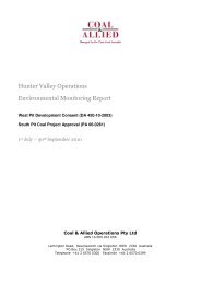
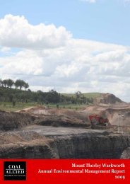
The proposed landform and rehabilitation strategy at <strong>Bengalla</strong> is shown in Figure 1 as<br />
adapted from the <strong>Bengalla</strong> SEE and MOP. The final landform will be undulating, with<br />
slopes generally to 10 o , and up to a maximum of 18 o on the low wall. Erosion and<br />
sediment control and water management structures will be incorporated into the<br />
landform as rehabilitation progresses. The landform will be predominately revegetated to<br />
improved pastures and trees. Where possible, any tree planting will be connected to<br />
remnant areas of forest or woodland, so as to provide corridors for wildlife migration.<br />
The Synoptic Plan: Integrated Landscapes for <strong>Coal</strong> Mine Rehabilitation in the Hunter<br />
Valley of New South Wales (Synoptic Plan) (DMR, 1999) identifies potential vegetation<br />
corridors across the Hunter Valley and encourages the integration of mine rehabilitation<br />
with remnant vegetation. The Synoptic Plan recommended the reconstruction and<br />
enhancement of the riparian corridor along Dry Creek (see Figure 1). As the riparian<br />
corridor along Dry Creek will not be disturbed by currently approved mining operations,<br />
the recommendations of the Synoptic Plan have not been incorporated into this RLMP.<br />
The management of the riparian corridor along Dry Creek will be further considered<br />
during the detailed development of the final Mine Closure Plan. Tree plantings completed<br />
for rehabilitation purposes at <strong>Bengalla</strong> will aim to link to remnant vegetation.<br />
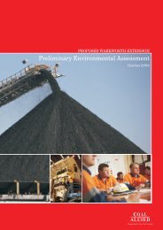
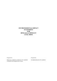
The post-mining land capability for <strong>Bengalla</strong> is shown on Figure 2. A comparison of the<br />
pre and post-mining land capability within the DA area are shown in Table 3, with a<br />
relatively small reduction in Class V land capability area resulting due to the final void.<br />
Table 3<br />
Pre-<strong>Mining</strong> & Post-<strong>Mining</strong> Land Capability Comparison<br />
Class<br />
Pre-mining<br />
(ha)<br />
Postmining<br />
(ha)<br />
III 75.7 75.7<br />
IV 188.6 188.6<br />
V 1,378.2 1,272.4<br />
Class M<br />
(Void)<br />
Land Description<br />
Regular cultivation with intensive soil conservation<br />
measures such as contour banks and waterways<br />
Grazing and occasional cultivation with simple practices<br />
such as stock control and fertiliser application<br />
Grazing and occasional cultivation with intensive soil<br />
conservation measures such as contour ripping and banks<br />
- 105.8 Unsuitable for rural production<br />
Ref: 071025 bmc rehabilitation & landscape mp Page 7
1 80<br />
1 5 0<br />
17 0<br />
6 0<br />
1<br />
1 8 0<br />
140<br />
1 7 0<br />
16 0<br />
1 50<br />
River<br />
Hunter<br />
190<br />
14 0<br />
2 2 0<br />
2 1 0<br />
200<br />
220<br />
2 40<br />
2 70<br />
27 0<br />
260<br />
2 5 0<br />
2 4 0<br />
2 3 0<br />
2 20<br />
16 0<br />
1 5 0<br />
14 0<br />
3 0<br />
18 0<br />
1 9 0<br />
1 8 0<br />
1 9 0<br />
1 8 0<br />
1 6 0<br />
1 5 0<br />
1 70<br />
1 60<br />
14 0<br />
1 4 0<br />
15 0<br />
2 30<br />
2 2 0<br />
210<br />
2 0 0<br />
2 2 0<br />
1 80<br />
Creek<br />
2 00<br />
1 9 0<br />
2 1 0<br />
2 3 0<br />
Dry<br />
18 0<br />
1 9 0<br />
1 7 0<br />
2 0 0<br />
21 0<br />
1 60<br />
1 8 0<br />
1 9 0<br />
17 0<br />
1 50<br />
1 8 0<br />
1 7 0<br />
1 6 0<br />
1 5 0<br />
14 0<br />
16 0<br />
14 0<br />
Legend<br />
DA Boundary<br />
Native Trees<br />
Rehabilitated Overburden<br />
Dams<br />
Tree Screens<br />
Scattered Remnant Vegetation<br />
Visual Bund<br />
Drainage<br />
Final Void Stabilised Waterways<br />
Co-ordinate System: MGA Zone 56<br />
Source : <strong>Bengalla</strong> MOP ( 2006 )<br />
BENGALLA MINE<br />
Aerial Data Dec 2006<br />
Conceptual Post-<strong>Mining</strong> Landform<br />
Cad File: 02350D.dwg<br />
Date:17.07.07 Drawn:JD<br />
Figure<br />
1
2 2 0<br />
1 80<br />
1 5 0<br />
17 0<br />
6 0<br />
1<br />
1 8 0<br />
140<br />
1 7 0<br />
16 0<br />
1 50<br />
River<br />
Hunter<br />
190<br />
14 0<br />
2 2 0<br />
2 1 0<br />
200<br />
220<br />
2 40<br />
2 70<br />
27 0<br />
260<br />
2 5 0<br />
2 4 0<br />
2 3 0<br />
2 20<br />
16 0<br />
1 5 0<br />
14 0<br />
3 0<br />
18 0<br />
1 9 0<br />
1 70<br />
1 80<br />
1 8 0<br />
1 9 0<br />
1 8 0<br />
1 60<br />
1 6 0<br />
1 5 0<br />
1 4 0<br />
1 50<br />
15 0<br />
14 0<br />
14 0<br />
2 0 0<br />
2 2 0<br />
210<br />
1 9 0<br />
18 0<br />
1 9 0<br />
1 7 0<br />
1 60<br />
1 8 0<br />
1 9 0<br />
17 0<br />
1 6 0<br />
14 0<br />
2 00<br />
2 1 0<br />
1 5 0<br />
2 30<br />
2 0 0<br />
2 3 0<br />
21 0<br />
1 8 0<br />
1 7 0<br />
16 0<br />
Legend<br />
DA Boundary<br />
<strong>Bengalla</strong> EIS Study Area<br />
Class M<br />
Class II<br />
Class IV<br />
Class V<br />
Class V - 10° slope<br />
Class V - 18° slope<br />
Final Void<br />
Co-ordinate System: MGA Zone 56<br />
Source : <strong>Bengalla</strong> MOP ( 2006 )<br />
BENGALLA MINE<br />
Aerial Data Dec 2006<br />
Conceptual Post-<strong>Mining</strong> Land Capability<br />
Cad File: 02351D.dwg<br />
Date:19.07.07 Drawn:JD<br />
Figure<br />
2
Rehabilitation & Landscape<br />
Management Plan<br />
3.2 Five Year Rehabilitation & Management Measures<br />
The <strong>Bengalla</strong> EMS contains Environmental Procedures (EP) that specifically address<br />
rehabilitation and related activities. These are shown in Appendix B and include:<br />
• EP 5.1 Rehabilitation;<br />
• EP 2.1 Cultural Heritage Management; and<br />
• EP 10.2 Flora and Fauna.<br />
The following section details the key stages of the land disturbance and rehabilitation<br />
process at <strong>Bengalla</strong> and a summary of the management measures utilised. For further<br />
detail on the rehabilitation process, please refer to the EPs listed above in Appendix B.<br />
3.2.1 Clearing & Topsoil Stripping<br />
Prior to disturbing any new areas, a site inspection and Ground Disturbance Permit (GDP)<br />
is completed by the Environmental Specialist (or delegate) to identify any environmental<br />
issues associated with the disturbance of the area in accordance with EP 5.1.<br />
Three comprehensive flora and fauna assessments have been conducted in the DA<br />
Boundary in accordance with the relevant legislation. Only one threatened flora species<br />
(Bothriochloa biloba) was identified in these assessments and no other threatened flora<br />
or fauna have been identified at <strong>Bengalla</strong>.<br />
Nonetheless, all areas proposed for disturbance are surveyed by an appropriately<br />
qualified person and if B. biloba is present, a Botanist will identify relevant clumps<br />
suitable for relocation in selected areas of rehabilitation in accordance with EP 10.2.<br />
As illustrated on Figure 1, there is very limited existing remnant native tree cover within<br />
the approved disturbance area at <strong>Bengalla</strong>. However, prior to undertaking any<br />
disturbance, all habitat trees or seed trees are identified. Prior to, and during clearing,<br />
where available, seed is collected and any fauna present is relocated by an appropriately<br />
qualified person in accordance with EP 10.2.<br />
All suitable habitat trees are strategically relocated to established rehabilitation and any<br />
additional suitable hardwood timber which could be utilised for the purposes of farm<br />
fencing is identified and collected prior to clearing in accordance with EP 10.2.<br />
The pre-clearing inspection process also includes confirmation against the CNA<br />
Archaeology and Cultural Heritage database that no Aboriginal archaeology is located<br />
within the area to be disturbed.<br />
Ref: 071025 bmc rehabilitation & landscape mp Page 10
Rehabilitation & Landscape<br />
Management Plan<br />
All Aboriginal archaeological sites that have been identified and do not have consent to<br />
destroy under the National Parks and Wildlife Act 1974 (NPW Act) within the 21 year<br />
approved disturbance boundary are protected by fencing and signage in accordance with<br />
EP 2.1.<br />
No disturbance of any area occurs until the respective area has been approved via the<br />
Environmental Specialist (or delegate) in the GDP.<br />
Vegetation is then cleared and windrowed for use as fencing material and/or placed on<br />
rehabilitation for habitat enhancement. Other material is placed in-pit. Topsoil<br />
(approximately 100 – 150 mm) is stripped in accordance with the MOP and EP 5.1 and<br />
either directly placed on shaped spoil areas for rehabilitation or in circumstances where<br />
this is not possible, it is stockpiled for later use in rehabilitation.<br />
3.2.2 Topsoil Stockpiling<br />
In accordance with EP 5.1, all topsoil stockpiles are located in designated areas and<br />
constructed to a shape and depth as specified in the MOP. Each topsoil stockpile is<br />
pegged, marked with signage, with the topsoil stockpile surveyed annually for its volume.<br />
The topsoil stockpile is to be located:<br />
• As close as practicable and readily accessible to respreading areas;<br />
• Where they will not interfere with present and future mining and ancillary<br />
operations;<br />
• At least 10 m from trees or watercourses; and<br />
• In areas that will allow free drainage and minimal soil erosion.<br />
Topsoil stockpiles that will not be used for longer than three months will be shaped,<br />
fertilised and revegetated with a cover crop specified by the Environmental Specialist to<br />
provide initial stability, maintain soil viability and minimise erosion. When removing soil<br />
from stockpiles to place on shaped areas all practical measures (including spraying<br />
and/or removing the top 20 mm as proven to be effective through trials) will be taken to<br />
remove weed seed banks prior to re-spreading.<br />
3.2.3 Shaping & Topsoiling<br />
Once mining activities in an area have ceased, the overburden is shaped according to the<br />
final landform design (Figure 1). Topsoil is then re-spread on the shaped areas to a<br />
minimum depth of 100 mm, in accordance with EP5.1. Contour banks are constructed at<br />
regular intervals down the slope of the rehabilitation area. The area is then rock-raked to<br />
generally remove rocks greater than 200 mm in diameter. Areas are then scarified along<br />
the contour to assist in seed germination and water infiltration.<br />
Ref: 071025 bmc rehabilitation & landscape mp Page 11
Rehabilitation & Landscape<br />
Management Plan<br />
3.2.4 Revegetation<br />
Revegetation is undertaken progressively and as soon as practicable after the completion<br />
of surface preparation. Seeding of a rehabilitation area commences as soon as practical<br />
after raking using either a tractor mounted seed spreader or direct hand seeding.<br />
Generally, pasture areas and trees and shrub areas will be sown separately. Where<br />
utilised, tube stock may be planted in rip lines at approximately 5 m spacing and in an<br />
irregular pattern along the contour to achieve as natural a result as possible.<br />
The typical pasture and tree species used for revegetation are shown in Appendix C.<br />
3.2.5 Monitoring<br />
In accordance with EP 5.1 access to rehabilitated areas is closed to all equipment and<br />
vehicles not involved in the rehabilitation process.<br />
Site inspections of rehabilitated areas are carried out on an annual basis as required by<br />
EP 5.1. The main aim of these inspections is to confirm rehabilitation processes, identify<br />
areas of erosion, the presence of weeds and/or feral animals and ensure appropriate<br />
maintenance activities are undertaken.<br />
In order to evaluate and monitor vegetation in these annual inspections, a monitoring<br />
transect will be established at regular intervals (approximately 300 m) along the<br />
overburden emplacement slope on rehabilitation which has been established for greater<br />
than two years with the following descriptive parameters recorded:<br />
• Describe the vegetation in general terms;<br />
• Assess and describe the grass cover: namely, the total percentage cover and<br />
dominant species;<br />
• Assess, describe and estimate the weed cover (%) and the dominant weed species<br />
(in particular declared noxious weeds);<br />
• Estimate the percentage of bare ground;<br />
• Describe tree health, noting signs of drought stress, nutrient deficiencies or<br />
disease;<br />
• Assess the overall percentage of healthy trees; and<br />
• Establish and mark a permanent photo point for visual comparison over time.<br />
Further, the annual inspection will also record the following parameters at each transect<br />
to assess and monitor soils and erosion:<br />
• Describe the type and extent of erosion (e.g. gully erosion, erosion rills, tunnel<br />
erosion failed water management structures);<br />
Ref: 071025 bmc rehabilitation & landscape mp Page 12
Rehabilitation & Landscape<br />
Management Plan<br />
• Record the location, number and dimension of all gullies greater than 30 cm in<br />
width or depth; and<br />
• Take a representative soil sample how and from where and analyse for pH, EC,<br />
organic carbon, nitrogen and total and available phosphorous.<br />
A qualified surveyor will survey all rehabilitated areas, with the information reported in<br />
the Annual Environmental Management Plan (AEMR). Annual inspections of rehabilitated<br />
areas will be carried out in conjunction with the DPI to determine progress against the<br />
initial completion criteria in Table 4.<br />
Flora and fauna surveys on rehabilitation and areas ahead of mining are conducted every<br />
five years by a suitably qualified ecologist in accordance with EP 10.2.<br />
3.2.6 Maintenance<br />
An annual maintenance program is conducted on rehabilitated areas for up to five years<br />
after the initial sowing in accordance with EP 5.1. This will include fertiliser application as<br />
required. Feral animal control is undertaken following consultation with and allocation of<br />
permits from DECC as required. Any feral animal culling is conducted by registered<br />
personnel.<br />
Inspections for weeds are generally undertaken every six months and if weed control is<br />
required, the weeds are sprayed during active growth for effective control. The success<br />
of spraying will be assessed by visual inspections two weeks after spraying. Follow up<br />
spraying may be required if control is not achieved with the first application.<br />
Bushfire risk on rehabilitated areas is managed in accordance with the DoP approved CNA<br />
Generic Bushfire Management Plan. <strong>Bengalla</strong> has in place a number of effective measures<br />
for the prevention and control of bushfires which include maintaining fire access trails,<br />
minimising and regular clearing of undergrowth, clearing debris, grazing of pastures and<br />
minimisation of fuel build-up.<br />
3.2.7 Rehabilitation Trials & Research<br />
In selected areas of rehabilitation, <strong>Bengalla</strong> will continue to undertake rehabilitation<br />
trials in consultation with DPI which will utilise best practice mediums and procedures,<br />
with progress and results reported in the AEMR. These may include trials associated<br />
with the use of biosolids, planting in different mediums, mulching/gypsum application,<br />
use of varied types of stock/seeds and consultation with other mining operations in<br />
relation to practical and proven technologies.<br />
Ref: 071025 bmc rehabilitation & landscape mp Page 13
Rehabilitation & Landscape<br />
Management Plan<br />
3.3 Medium & Long-term Management Measures<br />
The rehabilitation measures described in Section 3.2 will continue to be implemented<br />
over the life of mining at <strong>Bengalla</strong>. This will ensure the rehabilitation activities result in a<br />
final landform which is undulating and free-draining (Figure 1) and has post-mining land<br />
capability (Figure 2) as determined in consultation with relevant stakeholders.<br />
In particular, the completion criteria and performance monitoring discussed further in<br />
Section 3.4 provide an evaluation mechanism of the rehabilitation measures being<br />
implemented. The rehabilitation measures are subject to continuous review and<br />
improvement, reflecting the results of performance monitoring and progress towards<br />
rehabilitation targets.<br />
3.4 Completion Criteria<br />
Initial completion criteria for the short-term (annual), medium-term (< 5 yrs) and longterm<br />
(life of mine) have been developed to achieve the site rehabilitation objectives and<br />
are shown in Table 4. Rehabilitation that achieves the completion criteria will be<br />
considered to be sustainable without ongoing management and therefore suitable for<br />
mining lease relinquishment.<br />
The completion criteria include success indicators and monitoring requirements to<br />
monitor the successful establishment of rehabilitation and trigger remedial action, where<br />
necessary. This will ensure that rehabilitation achieves the completion criteria in a<br />
suitable timeframe, consistent with the mine closure plan.<br />
Ref: 071025 bmc rehabilitation & landscape mp Page 14
Rehabilitation & Landscape<br />
Management Plan<br />
Table 4<br />
<strong>Bengalla</strong> Initial Rehabilitation Completion Criteria<br />
Objective Long-term Completion Criteria<br />
(i.e. Life of Mine)<br />
OVERBURDEN EMPLACEMENT<br />
• Internal slopes
Rehabilitation & Landscape<br />
Management Plan<br />
Objective<br />
Long-term Completion Criteria<br />
(i.e. Life of Mine)<br />
Medium-term Success Indicators<br />
(i.e. < 5 years)<br />
Short-term Monitoring<br />
(i.e. Annually)^<br />
• Minimum of 70% vegetative cover<br />
over 80% of rehabilitated areas *<br />
• Suitable pasture species dominant<br />
• Minimal presence of weeds (esp.<br />
Galenia sp)<br />
• Weed control and ameliorative<br />
measures as necessary<br />
• Tree plots recruitment rates are<br />
equal to or exceed mortality rates<br />
• Grazing conducted in accordance<br />
with land classes<br />
• Tree plots indicating good growth<br />
and mortality rates – nearing<br />
completion criteria<br />
• Successful small trials of grazing<br />
• Monitoring of vegetation and<br />
erosion and sediment control as<br />
discussed in Section 3.2.5<br />
Surface run-off is not<br />
polluting waters<br />
off site<br />
• Water leaving site must meet EPL<br />
6538 criteria of pH between 6.5<br />
and 9.5 and TSS of < 120 mg/L<br />
• Water monitoring results within<br />
limits of EPL 6538 and all dirty water<br />
retained on site<br />
• Monitoring and inspection of<br />
water management structures by<br />
appropriately qualified person<br />
FINAL VOID<br />
• Design to stable gradient by<br />
geotechnical personnel, if<br />
necessary blast<br />
• Final high wall meets design<br />
requirements, geotechnical stable<br />
• Monitoring confirms stability<br />
• Monitoring of high wall stability<br />
All hazards associated<br />
with the final high<br />
wall and low wall are<br />
controlled<br />
• Fencing established along the<br />
entire length of the final high wall,<br />
preventing pedestrian and live<br />
stock access<br />
• Berms, trenches and catch<br />
benches established at<br />
appropriate intervals where<br />
necessary<br />
• Implementation and ongoing<br />
maintenance of fencing<br />
• Exclusion of access<br />
• Implementation of berms and<br />
trenches at regular intervals<br />
• Stability of berms and trenches<br />
• Regular monitoring of fence<br />
condition and restriction of<br />
access<br />
• Regular monitoring and/or<br />
maintenance of berms and<br />
trenches<br />
Ref: 071025 bmc rehabilitation & landscape mp Page 16
Rehabilitation & Landscape<br />
Management Plan<br />
Objective<br />
Final low wall is<br />
shaped, stable and<br />
maintains pasture<br />
cover<br />
Long-term Completion Criteria<br />
(i.e. Life of Mine)<br />
Medium-term Success Indicators<br />
(i.e. < 5 years)<br />
Short-term Monitoring<br />
(i.e. Annually)^<br />
• Low wall slope gradient is at
Rehabilitation & Landscape<br />
Management Plan<br />
4.0 Final Void Management Plan<br />
As discussed in Section 1.3, this RLMP provides a preliminary Final Void Management<br />
Plan. A detailed Final Void Management Plan will be included in a revision of this RLMP<br />
within five years of mine closure, however, preliminary final void justification, design<br />
criteria and control measures are provided below utilising available information.<br />
4.1 Justification<br />
Based on the currently approved mine plan at <strong>Bengalla</strong>, a final void will be created in<br />
2017 as shown on Figure 1, consistent with the <strong>Bengalla</strong> EIS and SEE. The void will be<br />
aligned generally north-south and will have a strike length of approximately 2.9 km. The<br />
void will be formed with a depth up to -14 m RL and will be retained as an open water<br />
body.<br />
The currently approved location of the final void is at the economic limit of approved<br />
open cut mining at this stage and thus, has no alternative location. However, as<br />
previously noted in Section 1.2, recoverable coal reserves have been identified to the<br />
west of currently approved mining operations at <strong>Bengalla</strong>. Should <strong>Bengalla</strong> seek, and<br />
ultimately be granted approval to continue mining to uncover these reserves, the location<br />
of the final void will change.<br />
The currently approved void will remain as an open water body as all available<br />
overburden will be used to create undulating and a free-draining overburden<br />
emplacement. On this basis, is not environmentally or economically feasible to alter the<br />
use or location of the final void at this stage.<br />
Predictive groundwater modelling of the final void was undertaken in 2006 by<br />
Australasian Groundwater and Environmental Consultants (AGE). This modelling<br />
confirmed that an equilibrium void lake water level will be reached after more than 200<br />
years. At this level the inflows to the void from groundwater and surface water runoff<br />
are balanced by evaporation from the surface of the void water storage.<br />
The equilibrium void water level is approximately 150 m below the crest of the void and<br />
there is therefore a very low risk that the void would overtop even during an extreme<br />
rainfall event. The equilibrium void water level is also well below (in the order of 75 -<br />
105 m) the pre-mining groundwater levels. Hence the open void will act as a<br />
groundwater sink and no contamination of groundwater will occur (AGE, 2006).<br />
The location and use of the final void will not result in any adverse environmental<br />
impacts and is situated well above the 1:100 Hunter River flood level.<br />
Ref: 071025 bmc rehabilitation & landscape mp Page 18
Rehabilitation & Landscape<br />
Management Plan<br />
The location and use of the final void will continue to be investigated during detailed<br />
mine closure planning and further detail will be provided in the next revision of the Final<br />
Void Management Plan.<br />
4.2 Design Criteria<br />
The final void will be managed and designed such that the low wall is at a slope of no<br />
greater than 18 o and will be rehabilitated with pasture species suitable for surface<br />
stability. Benches will be incorporated at regular intervals along the low wall where<br />
practical (Hannan, 2003). Any exposed coal seams will be covered in accordance with<br />
EP 4.1 Closure Planning Guidelines.<br />
The steep slope of the high wall will be designed to a stable gradient, based on<br />
assessments of geotechnical stability and risk, to be undertaken as agreed with DPI.<br />
Fencing will be constructed across the high wall to restrict cattle and pedestrian access as<br />
agreed with DPI. A steep ditch and bund wall may also be constructed at a short distance<br />
back from the high wall, so as to prevent inadvertent vehicular access as agreed with<br />
DPI.<br />
Water management structures will be utilised to divert as much of the surrounding<br />
surface water catchment away from the void. However, the void will still collect water<br />
draining from the high wall and from the area of the low wall beneath the lowest<br />
diversion bank. Diversion banks with a capacity to convey a relevant level of peak runoff<br />
storm events will be constructed above the low wall to convey and redirect runoff.<br />
4.3 Actions & Control Measures<br />
As described in Section 4.2, the action and control measures to manage any impacts of<br />
the final void will be incorporated into the void design. The detailed Final Void<br />
Management Plan will include detailed design and specification of the final void and<br />
associated control measures. Development of the Plan will also include further<br />
assessment and stakeholder consultation in relation to the potential post-mining land use<br />
for the void.<br />
Ref: 071025 bmc rehabilitation & landscape mp Page 19
Rehabilitation & Landscape<br />
Management Plan<br />
5.0 Mine Closure Plan<br />
As discussed in Section 1.3, this RLMP provides a preliminary conceptual Mine Closure<br />
Plan. A detailed Mine Closure Plan will be developed at least five years prior to mine<br />
closure, however, preliminary design criteria and environmental management techniques<br />
for mine closure are provided below utilising available information.<br />
5.1 Objectives<br />
The key objective of site rehabilitation is to achieve an optimum post-mining land<br />
capability suitable for supporting a combination of grazing and native habitat land use.<br />
Detailed rehabilitation objectives and completion criteria, consistent with these<br />
post-mining land use objectives are listed in Table 4.<br />
5.2 Post-<strong>Mining</strong> Land Use Options<br />
Investigations have been undertaken in relation to a number of post-mining land use<br />
options within the DA Boundary (GSSE, 2004). Extensive face-to-face consultation was<br />
undertaken with over 60 near neighbours, regulators and community representatives<br />
during preparation of the <strong>Bengalla</strong> SEE. When stakeholders were asked during this<br />
consultation the majority stated that they would prefer a more natural looking landform<br />
with dense plantings of native trees and shrubs. This feedback was considered in the<br />
current selection of the conceptual post-mining land use option.<br />
The investigations were undertaken to determine feasible land uses on rehabilitated land<br />
considering land slope, class, water requirements and soil types. The potential land uses<br />
that were investigated included: cattle grazing, viticulture, industrial estates, commercial<br />
forestry, and other commercial/community enterprises. These potential land uses were<br />
then evaluated based on selection criteria such as:<br />
• Community and stakeholder acceptance;<br />
• Health and safety considerations;<br />
• Potential environmental impacts;<br />
• Regulatory requirements and legal liability; and<br />
• Contribution to the local economy and employment.<br />
Although viticulture was assessed and determined to substantially assist in long-term<br />
final landform stability and minimise noise, dust and odour impacts on near neighbours,<br />
viticulture as a post-land use option was considered to be an incompatible broad<br />
community land use which would only moderately satisfy legal and regulatory<br />
requirements. The investigations found that the physical and chemical characteristics of<br />
the shaped and rehabilitated overburden would be incompatible with the needs of<br />
Ref: 071025 bmc rehabilitation & landscape mp Page 20
Rehabilitation & Landscape<br />
Management Plan<br />
viticulture as a growth medium. Further, significant issues were identified in regards to<br />
the adequate supply of water resources and drainage on the shaped overburden to<br />
satisfy the needs of viticulture. As viticulture is a water-reliant industry, viticulture as a<br />
post-mining option would inevitably be water intensive and reduce water availability in<br />
the local community.<br />
Commercial forestry was also assessed as a final land use option at <strong>Bengalla</strong> and was<br />
found to minimise environmental impacts associated with water resources, dust, noise<br />
and heritage, whilst moderately satisfying legal and regulatory requirements. However,<br />
this option was discounted primarily as the land use does not promote ecologically<br />
sustainable development, is not a broad community land use and does not encourage<br />
sustainable employment opportunities for the local community. The investigations also<br />
highlighted that commercial forestry would not be a compatible and logical land use with<br />
surrounding industry (i.e. mining operations and ancillary services) and would not<br />
aesthetically blend with its surroundings. For these reasons, commercial forestry as a<br />
final land use option at <strong>Bengalla</strong> was discounted.<br />
The establishment of an industrial estate or a training centre as a final land use at<br />
<strong>Bengalla</strong> was assessed and was generally found to moderately satisfy legal and<br />
regulatory requirements, minimise environmental impacts, have a broad acceptance by<br />
the community and would promote sustainable employment opportunities. However, this<br />
option was primarily discounted due to significant restrictions in site access for power,<br />
roads and ancillary services to the top of the shaped and rehabilitated overburden<br />
emplacement areas. Further, the slopes of the rehabilitated overburden areas were also<br />
found to restrict the areas of appropriate development land due to stability and safety<br />
requirements.<br />
Cattle grazing as a final land use at <strong>Bengalla</strong> was found to satisfy corporate, legal and<br />
regulatory requirements for mine closure and would be fully compatible with surrounding<br />
land use and landforms in regards to visual amenity. Cattle grazing was also found to<br />
have a high level of acceptance from the local community and would maximise the<br />
likelihood of long-term landform stability.<br />
The establishment of native bushland at <strong>Bengalla</strong> post mine closure was also found to<br />
satisfy corporate, legal and regulatory requirements for mine closure and would be fully<br />
compatible with surrounding land use and landforms in regards to visual amenity. Native<br />
bushland would also maximise long-term final landform stability and would minimise<br />
environmental issues associated with water resources, dust, noise, odour and heritage.<br />
After consideration of selection criteria and extensive feedback from community<br />
consultation, a mixture of native bushland and cattle grazing were identified to be the<br />
most suitable post-mining land uses. Grazing and native bushland regeneration has<br />
Ref: 071025 bmc rehabilitation & landscape mp Page 21
Rehabilitation & Landscape<br />
Management Plan<br />
therefore been adopted as the preferred post-mining land use in suitable areas of the<br />
site, with a focus on linking remnant vegetation with rehabilitation.<br />
Further assessment and stakeholder consultation in relation to mine closure and<br />
post-mining land uses will be conducted during preparation of the detailed Mine Closure<br />
Plan.<br />
5.3 Mine Infrastructure<br />
In accordance with the <strong>Mining</strong> Lease conditions and the current development consent,<br />
BMC is required to remove all infrastructure, plant equipment and works with no ongoing<br />
beneficial use after mine closure in 2017. However, it is expected that many<br />
infrastructure items may be retained at mine closure due to their beneficial use for a<br />
variety of post-mining land uses. The need for decommissioning of site infrastructure will<br />
be assessed in detail in consultation with relevant stakeholders during preparation of the<br />
MOP and detailed Mine Closure Plan.<br />
As discussed in Section 1.2, if <strong>Bengalla</strong> seeks and gains additional approval to continue<br />
mining operations to the west, all the relevant infrastructure will be retained and<br />
enhanced and maintained in accordance with EP 10.1.<br />
5.4 Environmental Management<br />
Ongoing monitoring and management of environmental performance will continue to be<br />
undertaken for five years after mine closure or until such time as monitoring results<br />
demonstrate that the site meets the closure criteria. Detailed closure criteria and<br />
associated monitoring and maintenance programs will be included in the revised Mine<br />
Closure Plan. Mine closure monitoring will include at least the following:<br />
• Rehabilitation and closure completion criteria/success indicators;<br />
• Groundwater;<br />
• Surface water; and<br />
• Air quality.<br />
5.5 Performance Measurement<br />
The performance of the rehabilitation of the site at mine closure will be monitored in<br />
accordance with the monitoring programs specified in Table 4. The assessment of the<br />
monitoring results will enable the confirmation of achievement of the success indicators<br />
and associated completion criteria. Once the completion criteria have been achieved, as<br />
demonstrated by monitoring results, application for <strong>Mining</strong> Lease relinquishment will be<br />
requested.<br />
Ref: 071025 bmc rehabilitation & landscape mp Page 22
Rehabilitation & Landscape<br />
Management Plan<br />
6.0 Stakeholder Consultation<br />
BMC undertakes regular consultation with its stakeholders on matters relating to<br />
rehabilitation progress, performance and mine closure. Stakeholders include but are not<br />
limited to: the <strong>Bengalla</strong> Mine Community Consultative Committee (BMCCC), local<br />
residents, regulatory authorities, employees & contractors, Joint Venture partners, local<br />
industry, universities and schools within the region.<br />
The MOP provides information for stakeholders, outlining rehabilitation activities<br />
undertaken, rehabilitation success and progress, and planned rehabilitation strategies<br />
going forward.<br />
The AEMR provides an update on rehabilitation progress and the details and success of<br />
any rehabilitation ameliorative measures undertaken. The AEMR is publicly available on<br />
<strong>Bengalla</strong>’s website and copies are made available for the community and the BMCCC.<br />
This RLMP incorporates feedback from stakeholders in relation to rehabilitation and mine<br />
closure. Further stakeholder consultation will be undertaken during the development of<br />
the detailed Mine Closure Plan.<br />
7.0 Reporting & Review<br />
The outcomes of rehabilitation and mine closure activities may be reported by the<br />
following methods:<br />
• Ongoing consultation with the BMCCC and local landholders as appropriate;<br />
• Mine closure newsletters and associated consultation with stakeholders;<br />
• Activities relating to rehabilitation and mine closure are to be reported in the<br />
<strong>Bengalla</strong> AEMR; and<br />
• A five yearly review of this RLMP (and within five years of mine closure).<br />
Copies of this RLMP and any subsequent revisions will be provided to the DPI following<br />
approval by DoP.<br />
Ref: 071025 bmc rehabilitation & landscape mp Page 23
Rehabilitation & Landscape<br />
Management Plan<br />
8.0 Responsibilities<br />
Table 5 details management measures and summarises responsibilities. Responsibilities<br />
may be delegated as required.<br />
Table 5<br />
Management Measures and Responsibilities<br />
Ref Control Measure Responsibility Timing CNA EMS<br />
1<br />
2<br />
3<br />
4<br />
5<br />
6<br />
Ensure rehabilitation design meets the<br />
requirements of the MOP and as outlined in<br />
Section 3.1.<br />
Complete rehabilitation in accordance with the<br />
management techniques of the EMS and as<br />
described in Section 3.2.<br />
Undertaken annual inspections of rehabilitation,<br />
focusing on vegetation and soil parameters<br />
described in Section 3.2.5.<br />
Conduct a flora and fauna survey of<br />
rehabilitation and future mining areas with an<br />
appropriately qualified ecologist.<br />
Undertake rehabilitation maintenance techniques<br />
discussed in Section 3.2.6 and implement<br />
ameliorative action as required.<br />
Monitor and review progress against success<br />
indicators and completion criteria listed in Table<br />
4. Apply ameliorative measures as necessary.<br />
Mine Manager Annually EP 5.1<br />
Mine Manager Annually EP 5.1<br />
Environmental<br />
Specialist<br />
Environmental<br />
Specialist<br />
Environmental<br />
Specialist<br />
Environmental<br />
Specialist<br />
Annually<br />
Five<br />
Yearly<br />
EP 5.1,<br />
EP 10.2<br />
EP 5.1,<br />
EP 10.2<br />
Annually EP 5.1<br />
Six<br />
monthly<br />
EP 5.1<br />
7<br />
Review and update conceptual completion<br />
criteria based on monitoring results.<br />
Environmental<br />
Specialist<br />
Ongoing EP 5.1<br />
8<br />
Undertake further investigation and consultation<br />
in relation to the post-mining land use at<br />
<strong>Bengalla</strong>.<br />
Environmental<br />
Specialist<br />
Five<br />
Yearly<br />
EP 5.1<br />
9<br />
Provide further detail and planning on the mine<br />
closure strategy and final void design in next<br />
revision of the RLMP.<br />
Environmental<br />
Specialist<br />
Five<br />
Yearly<br />
EP 5.1<br />
Ref: 071025 bmc rehabilitation & landscape mp Page 24
Rehabilitation & Landscape<br />
Management Plan<br />
9.0 References<br />
• <strong>Australia</strong>n and New Zealand Minerals and Energy Council & Minerals Council of<br />
<strong>Australia</strong> (2000) Strategic Framework for Mine Closure.<br />
• <strong>Bengalla</strong> <strong>Mining</strong> <strong>Company</strong> (2006) <strong>Bengalla</strong> Annual Environmental Management<br />
Report.<br />
• <strong>Bengalla</strong> <strong>Mining</strong> <strong>Company</strong> (2006) <strong>Bengalla</strong> <strong>Mining</strong> Operations Plan, September<br />
2006.<br />
• Department of Planning (1995) Development Consent - <strong>Bengalla</strong> <strong>Coal</strong> Mine<br />
(DA 211/93).<br />
• Department of Planning (2006) Modification to Development Consent - <strong>Bengalla</strong><br />
<strong>Coal</strong> Mine (DA 211/93 (M1)).<br />
• Department of Mineral Resources (1999) Synoptic Plan: Integrated Landscapes for<br />
<strong>Coal</strong> Mine Rehabilitation in the Hunter Valley of New South Wales.<br />
• Department of Primary Industries – Mineral Resources Division (2006) Guidelines to<br />
the <strong>Mining</strong>, Rehabilitation and Environmental Management Process.<br />
• GSSE Environmental (2004) Post <strong>Mining</strong> Land use Options Report.<br />
• Hannan Environmental Management (2003) <strong>Bengalla</strong> Mine Closure Strategy and<br />
Plan.<br />
• HLA Envirosciences (1993) Environmental Impact Statement for <strong>Bengalla</strong> Open Cut<br />
<strong>Coal</strong> Mine.<br />
• Hansen Consulting (2006) <strong>Bengalla</strong> <strong>Mining</strong> <strong>Company</strong>, Modifications to <strong>Mining</strong><br />
Operations, Statement of Environmental Effects.<br />
• Nichols, O.G (2004) Development of rehabilitation criteria for native ecosystem<br />
establishment on coal mine in the Hunter Valley. <strong>Australia</strong>n <strong>Coal</strong> Association<br />
Research Program Project C13048.<br />
Ref: 071025 bmc rehabilitation & landscape mp Page 25
APPENDIX A<br />
REGULATORY CORRESPONDENCE
APPENDIX B<br />
RELEVANT CNA EMS PROCEDURES
Environmental procedure EP 5.1<br />
EP 5.1<br />
REHABILITATION<br />
1. Purpose<br />
To ensure that:<br />
• vegetation removal ahead of mining is conducted in accordance with a<br />
Ground Disturbance Permit (except for <strong>Bengalla</strong>) and managed to<br />
minimise soil erosion;<br />
• topsoil is correctly stripped, handled, stockpiled and reused;<br />
• disturbed areas are rehabilitated progressively in compliance with DMR<br />
requirements and are managed to ensure their success.<br />
2. Scope<br />
This Procedure applies to all CNA managed mines, infrastructure and any<br />
associated activity directly managed by CNA.<br />
3. Definitions<br />
DMR Compliance<br />
MOP<br />
Optimum Soil<br />
Moisture<br />
Operation meets requirements of the accepted MOP and<br />
Lease Conditions<br />
<strong>Mining</strong> Operations Plan<br />
The moisture content range where<br />
• soil compaction does not occur due to working of<br />
moist clays and<br />
• breakdown of soil structure does not occur due to<br />
insufficient moisture in the soil<br />
4. Actions<br />
4.1 Preparations for Vegetation Removal and Soil Stripping<br />
The area to be stripped, including roads and other infrastructure, will be<br />
determined by the Mine Planning Department, pegged and clearly marked<br />
by the Mine Surveyor or Civil Works Department prior to any work<br />
commencing.<br />
Prior to vegetation removal and soil stripping:<br />
• a Ground Disturbance Permit must be obtained (except at <strong>Bengalla</strong>) from<br />
Environmental Services by the relevant job coordinator or CNA person<br />
title<br />
EP 5.1<br />
REHABILITATION<br />
date issued<br />
3/8/04<br />
revision status<br />
1.3<br />
date reviewed<br />
20/1/05<br />
Printed documents are uncontrolled. Check the <strong>Coal</strong> & Allied Intranet for the latest version of this document.<br />
page<br />
1 of 8
Environmental procedure EP 5.1<br />
responsible for the project. At <strong>Bengalla</strong>, prior consultation with the<br />
Environmental Section is required before disturbance;<br />
• a visual inspection will be conducted for Aboriginal artifacts. Any<br />
artifacts found will be managed in accordance with the relevant<br />
procedures;<br />
• a visual flora and fauna inspection will be conducted to monitor for<br />
threatened species and to identify fauna that might require relocation<br />
prior to clearing. Environmental Services will be notified of any issues<br />
arising from the inspection;<br />
• a visual assessment of the vegetation will be conducted to identify<br />
available seed and timber resources to be collected or removed;<br />
• an assessment will be made of the depth, volume and characteristics of<br />
the topsoil to be removed;<br />
• diversion banks and drains will be constructed to prevent soil erosion as<br />
required by CNA’s erosion and sediment control management plan;<br />
• contractors undertaking vegetation removal, topsoil stripping and<br />
overburden removal will be briefed on their environmental<br />
responsibilities.<br />
4.2 Vegetation Removal<br />
Vegetation, not required for other purposes, and rocks will be pushed into<br />
windrows located away from any standing trees.<br />
All grass will be left to be recovered with the topsoil.<br />
Trees and logs will be cut to a size manageable by the shovel. Following<br />
topsoil removal and blasting, this material will be pushed on to the pre-strip<br />
area for removal with the overburden.<br />
A watch will be maintained for Aboriginal objects during the clearing and<br />
soil removal operations. If any objects are encountered, clearing will cease<br />
in that area and the Manager Environmental Services will be notified.<br />
4.3 Soil Stripping<br />
Soil stripping will be to be undertaken in accordance with the <strong>Mining</strong><br />
Operations Plan.<br />
Topsoil will be stripped by bulldozer or scraper to the depth determined by<br />
the MOP or until subsoil is observed by the plant operator or supervisor.<br />
Guidance on stripping depth will be sought from the Specialist,<br />
Rehabilitation and Landcare if there is any uncertainty.<br />
Topsoil stripping will not be undertaken in windy conditions that will cause<br />
excessive dust to be generated (see EP 8.2 Dust Management, Mobile<br />
Equipment).<br />
The water content of the soil to be stripped is an important consideration:<br />
title<br />
EP 5.1<br />
REHABILITATION<br />
date issued<br />
3/8/04<br />
revision status<br />
1.3<br />
date reviewed<br />
20/1/05<br />
Printed documents are uncontrolled. Check the <strong>Coal</strong> & Allied Intranet for the latest version of this document.<br />
page<br />
2 of 8
Environmental procedure EP 5.1<br />
• whenever possible, topsoil will be stripped while it is reasonably moist to<br />
avoid dust or the loss of soil structure;<br />
• during dry conditions topsoil should be watered to prevent dust<br />
generation;<br />
• topsoil must not be stripped when it is wet, as this can result in the loss of<br />
soil structure and death of micro-organisms.<br />
Machinery movement over soil should be kept to a minimum during<br />
stripping operations to avoid compaction and loss of soil structure. Trucks<br />
and scrapers transporting soil must use designated roads.<br />
Where possible, soil will be transferred directly to and respread over shaped<br />
areas, eliminating the need for storage and rehandling.<br />
Stripped areas will be inspected to ensure that all soil usable for revegetation<br />
has been removed.<br />
4.4 Soil Stockpiling<br />
Soil stockpiles are to be located in designated areas and constructed to a<br />
shape and depth as specified in the relevant MOP.<br />
The Mine Surveyor or a contract surveyor engaged by Civil Works<br />
Department will peg out and sign off on the locations and volumes of soil<br />
stockpiles and record surface levels for the base of each stockpile. This<br />
information will be stored in the Survey computer system and forwarded to<br />
Environmental Services.<br />
Soil stockpiles should be located:<br />
• as close as practicable and readily accessible to respreading areas;<br />
• where they will not interfere with present and future mining and ancillary<br />
operations;<br />
• at least 10m from trees or watercourses;<br />
• in areas that will allow free drainage and minimal soil erosion;<br />
4.5 Maintenance of Soil Stockpiles<br />
The Environmental Specialist Rehabilitation and Landcare will maintain a<br />
Topsoils Stockpile Register.<br />
The register will contain annual data on the locations and volumes of all soil<br />
stockpiles, the formation new stockpiles and the removal of soil from<br />
stockpiles for respreading.<br />
All topsoil stockpiles are to be signposted.<br />
Stockpiles that will not be used for longer than three (3) months will be<br />
shaped, fertilised and revegetated with a cover crop specified by the<br />
Environmental Specialist Rehabilitation and Landcare to provide initial<br />
stability, maintain soil viability and minimise erosion.<br />
title<br />
EP 5.1<br />
REHABILITATION<br />
date issued<br />
3/8/04<br />
revision status<br />
1.3<br />
date reviewed<br />
20/1/05<br />
Printed documents are uncontrolled. Check the <strong>Coal</strong> & Allied Intranet for the latest version of this document.<br />
page<br />
3 of 8
Environmental procedure EP 5.1<br />
Regular inspections will be conducted for weed and erosion control.<br />
4.6 Spoil dumping<br />
Spoil dumping will be carried out in accordance with the <strong>Mining</strong> Operations<br />
Plan (MOP). In particular:<br />
• specifications for dumping profiles will be determined by the mine<br />
planning department;<br />
• dumping locations will be pegged by the Mine Surveyor;<br />
• bulk shaping, including the pushing down of benches and the removal of<br />
rock greater than 50cm in diameter, will be conducted in a manner that<br />
will minimise the need for final trimming;<br />
• waste materials being buried in the pit, such as reject coal fines, acid<br />
bearing spoil, waste tyres and vegetation will be buried in accordance<br />
with the requirements for each type of material.<br />
Spoil dumps will be inspected regularly by the Operation Supervisor and the<br />
Site Environmental Coordinator to ensure that they conform to these<br />
requirements.<br />
Shaped spoil dumps will be trimmed to achieve the required slopes as<br />
specified in the relevant MOP.<br />
Contours will be constructed where required and drainage lines will<br />
conform to all requirements to discharge water and minimise erosion.<br />
The final surface will be rock raked to remove rocks greater than 20cm in<br />
diameter. Waste rock will be dumped into a designated area of the pit.<br />
Shaped spoil dumps will be inspected and approved by the Environmental<br />
Specialist Rehabilitation and Landcare prior to surface preparation for<br />
topsoiling.<br />
4.7 Surface Preparation<br />
The area to be revegetated will be surveyed to ensure that the land surface<br />
generally conforms to Plan No. 5 of the relevant MOP.<br />
Gypsum will be applied at a rate of 5 to 10 tonnes per hectare to<br />
revegetation areas unless otherwise specified by Environmental Specialist<br />
Rehabilitation and Landcare.<br />
4.8 Soil Re-spreading<br />
Topsoil, subsoil or overburden can be used as the growing medium<br />
depending on the intended final use and land capability:<br />
• topsoil or an appropriate subsoil should be used as top dressing for<br />
pasture;<br />
title<br />
EP 5.1<br />
REHABILITATION<br />
date issued<br />
3/8/04<br />
revision status<br />
1.3<br />
date reviewed<br />
20/1/05<br />
Printed documents are uncontrolled. Check the <strong>Coal</strong> & Allied Intranet for the latest version of this document.<br />
page<br />
4 of 8
Environmental procedure EP 5.1<br />
• suitable overburden can be used for top dressing where trees and shrubs<br />
are to be planted and/or when suitable topsoil is not available.<br />
Topsoil or designated subsoil will normally be spread to a depth of 100mm<br />
on those areas to be seeded with grass unless specified otherwise by the<br />
Environmental Specialist Rehabilitation and Landcare.<br />
Topsoil should be at its optimum moisture content when it is spread.<br />
Topsoil will not be spread when it is:<br />
• excessively wet as this will cause compaction; or<br />
• dry as this could cause the generation of excessive dust.<br />
All unnecessary movement of machinery over respread soil will be avoided.<br />
Soil removed from stockpiles will be recorded in the Soils Register.<br />
Soil sampling and testing should be conducted to determine the properties of<br />
the soil and the requirements for fertiliser or other soil additives.<br />
4.9 Ploughing<br />
The top dressing areas should be ploughed or tined along the contour prior<br />
to revegetation.<br />
Rocks greater than 20cm in diameter must be removed from the surface of<br />
areas to be sown to pasture.<br />
4.10 Drainage Works<br />
Drainage works will be incorporated into the final landform to slow and<br />
direct water flow and minimise erosion on rehabilitated areas in accordance<br />
with the erosion and sediment control management plan.<br />
Drainage works will include channels and banks and sediment control<br />
structures to prevent sediments leaving the site and will be constructed in<br />
accordance with EP7.1 Water Management.<br />
4.11 Revegetation<br />
Revegetation will be undertaken progressively and as soon as practicable<br />
after the completion of surface preparation, ideally when the soil is moist<br />
and there is a likelihood of follow up rain.<br />
Revegetation areas will be pegged or fenced and closed to all equipment and<br />
vehicles not involved with the revegetation process.<br />
Generally, pasture areas and trees and shrub areas will be sown separately,<br />
in accordance with the rehabilitation management plan.<br />
Tree seeding will generally be carried out during autumn when germination<br />
is usually more successful. The tree seed should be mixed with a bulking<br />
agent mixture to facilitate broadcasting. Fertiliser must not be used as a<br />
bulking agent.<br />
title<br />
EP 5.1<br />
REHABILITATION<br />
date issued<br />
3/8/04<br />
revision status<br />
1.3<br />
date reviewed<br />
20/1/05<br />
Printed documents are uncontrolled. Check the <strong>Coal</strong> & Allied Intranet for the latest version of this document.<br />
page<br />
5 of 8
Environmental procedure EP 5.1<br />
Tree and shrub species will be planted in accordance with established<br />
silviculture practices. Planting may be in the form:<br />
• seedlings supplied as “Forestry” size tubestock; or<br />
• seeding with native tree seed in suitable areas.<br />
Tube stock should be planted in rip lines at approximately 5m spacing and<br />
in an irregular pattern along the contour to achieve as natural a result as<br />
possible.<br />
A species mix suitable for the area and seed application rates are included in<br />
Attachment EP5.1.1.<br />
4.12 Access<br />
All access is restricted on rehabilitated areas except for rehabilitation<br />
maintenance purposes and fire control.<br />
Rehabilitated areas will be fenced off once they are able to withstand<br />
grazing pressure. Tree and shrub plantings must be fenced if grazing is<br />
planned in adjacent pastures.<br />
4.13 Maintenance<br />
Rehabilitated areas will be inspected regularly to assess plant growth and<br />
determine the need for weed control, soil conservation work and general<br />
maintenance.<br />
An annual maintenance program will be conducted for up to 5 years after<br />
the initial sowing. This will include fertiliser application.<br />
4.14 Weed Control<br />
Inspections for weeds are generally undertaken every 6 months in relevant<br />
areas. If weed control requires chemical spraying, the chemicals to be used<br />
must be approved and the MSDS obtained prior to spraying. The weed<br />
contractor must provide proof of competency and experience.<br />
Weeds should be sprayed during active growth for effective control.<br />
The success of spraying will be assessed by visual inspections two weeks<br />
after spraying. Follow up spraying may be required if control is not<br />
achieved with the first application.<br />
A final inspection is to be carried out 6 months after spraying to ensure that<br />
weeds have been destroyed and re-infestation has not occurred.<br />
4.15 Erosion Control<br />
Measures to reduce soil erosion on areas being stripped and rehabilitated<br />
areas may include:<br />
title<br />
EP 5.1<br />
REHABILITATION<br />
date issued<br />
3/8/04<br />
revision status<br />
1.3<br />
date reviewed<br />
20/1/05<br />
Printed documents are uncontrolled. Check the <strong>Coal</strong> & Allied Intranet for the latest version of this document.<br />
page<br />
6 of 8
Environmental procedure EP 5.1<br />
• reducing the flow rate of water across the ground, particularly on<br />
exposed surfaces and in areas where water congregates;<br />
• constructing catch drains, contour ploughing and the placement of hay<br />
bales;<br />
• regrading gullies to a stable land form;<br />
• the placement of coarse material; and<br />
• revegetation.<br />
Rehabilitated areas, prestripping areas and other areas that are prone to<br />
erosion will be inspected regularly. Any erosion identified will be treated<br />
promptly to minimise damage to the land and protect the quality of water on<br />
the site (see EP7.1 Water Management).<br />
4.16 Dust Control<br />
If it becomes necessary to use the water cart or water sprays to control dust<br />
prior to topsoil stripping, on topsoil stockpiles or rehabilitated areas, clean<br />
water (ie: non-saline water) must be used. The use of saline water may<br />
degrade soil quality and kill vegetation (see EP8.2 Dust Management,<br />
Mobile Equipment).<br />
4.17 Monitoring and Reporting<br />
A qualified surveyor will survey all rehabilitated areas. This information<br />
will be used to compile the annual rehabilitation report to the DMR and<br />
CNA’s internal reporting requirements.<br />
An annual rehabilitation audit is undertaken to ensure all relevant<br />
management plans and <strong>Rio</strong> <strong>Tinto</strong> Standards are achieved.<br />
Annual inspections of rehabilitated areas will be carried out in conjunction<br />
with the DMR and DLWC to determine progress against government<br />
completion criteria. The Environmental Specialist Rehabilitation &<br />
Landcare will address any actions coming out of these inspections.<br />
5. Responsibilities<br />
Environmental<br />
Specialist<br />
Rehabilitation &<br />
Landcare<br />
• Overview CNA’s timber clearing, topsoil stripping<br />
and rehabilitation program.<br />
• Provide advice where required on topsoil stripping,<br />
topsoil management and rehabilitation<br />
• Conduct annual management audits of topsoil<br />
stockpiles and rehabilitated areas<br />
• Maintain a topsoil stockpile register<br />
• Preparation of DMR annual rehabilitation reports<br />
and CNA rehabilitation reports<br />
• Facilitate annual DMR / DLWC inspections and<br />
address any resultant actions<br />
title<br />
EP 5.1<br />
REHABILITATION<br />
date issued<br />
3/8/04<br />
revision status<br />
1.3<br />
date reviewed<br />
20/1/05<br />
Printed documents are uncontrolled. Check the <strong>Coal</strong> & Allied Intranet for the latest version of this document.<br />
page<br />
7 of 8
Environmental procedure EP 5.1<br />
Site Mine Planners<br />
Civil Works<br />
Department<br />
<strong>Mining</strong> Department<br />
• Prepare MOPs in accordance with DMR<br />
requirements<br />
• Ensure mine rehabilitation plans are consistent with<br />
the relevant MOP<br />
• Supervise contract rehabilitation works to meet MOP<br />
and EMS requirements<br />
• Obtain Ground Disturbance Permit prior to<br />
disturbing undisturbed ground<br />
• Excavate and place overburden in accordance with<br />
mine plans<br />
• Obtain Ground Disturbance Permit prior to<br />
disturbing undisturbed ground<br />
6. References<br />
Ground disturbance permit<br />
Attachment EP5.1.1: Species mix and seed application rates for mine<br />
rehabilitation<br />
Revisions<br />
Number Date Description of Change<br />
1 12/9/2003 First Release<br />
2 3/8/04 <strong>Bengalla</strong> ground disturbance process defined<br />
3 20/1/05 Weed inspection frequency defined<br />
title<br />
EP 5.1<br />
date issued<br />
3/8/04<br />
revision status<br />
1.3<br />
date reviewed<br />
20/1/05<br />
page<br />
8 of 8<br />
REHABILITATION<br />
Printed documents are uncontrolled. Check the <strong>Coal</strong> & Allied Intranet for the latest version of this document.
Environmental procedure EP 2.1<br />
EP 2.1<br />
CULTURAL HERITAGE MANAGEMENT<br />
1. Purpose<br />
To ensure that all cultural heritage sites, objects and places on CNA owned<br />
land are identified and properly managed and protected.<br />
2. Scope<br />
This procedure applies to the identification and management of all European<br />
and Indigenous Cultural Heritage matters associated with any activity<br />
directly managed by CNA.<br />
3. Definitions<br />
Aboriginal object:<br />
Aboriginal place:<br />
Aboriginal heritage<br />
site:<br />
Cultural Heritage:<br />
European heritage<br />
site:<br />
<strong>Mining</strong> Operations:<br />
Relic:<br />
Any deposit, object or material evidence (not being a<br />
handicraft made for sale) relating to the Aboriginal<br />
habitation of the area that comprises NSW, being habitation<br />
before or concurrent with (or both) the occupation of that<br />
area by persons of non-Aboriginal extraction, and includes<br />
Aboriginal remains. (National Parks and Wildlife Act 1974)<br />
Means any place declared to be an Aboriginal place under<br />
Section 84 of the National Parks and Wildlife Act 1974.<br />
Refers to an area containing identified Aboriginal objects,<br />
that is not declared to be an Aboriginal place under the<br />
National Parks and Wildlife Act 1974.<br />
Aboriginal and European matters of archaeological and/or<br />
heritage significance, including relics, sites, objects & places<br />
Refers to any area containing relics of European origin.<br />
Includes exploration, associated infrastructure, clearing and<br />
other mining related activities.<br />
Any deposit, object or material evidence which relates to the<br />
settlement of the area that comprises New South Wales, not<br />
being Aboriginal settlement, and is 50 or more years old<br />
(Heritage Act 1977).<br />
title<br />
EP 2.1<br />
Cultural Heritage Management<br />
date issued<br />
3/8/04<br />
revision status<br />
1.4<br />
date reviewed<br />
10/3/05<br />
Printed documents are uncontrolled. Check the <strong>Coal</strong> & Allied Intranet for the latest version of this document.<br />
page<br />
1 of 5
Environmental procedure EP 2.1<br />
4. Actions<br />
4.1 Ground Disturbance Permit<br />
Accessing areas not previously disturbed (excluding <strong>Bengalla</strong>) requires a<br />
Ground Disturbance Permit, which is available from the CNA Intranet. This<br />
form requires information such as; project description, duration, Project Coordinator,<br />
archaeology site status, flora & fauna and other EIS restrictions.<br />
This information must be entered and signed off by an Environmental<br />
Services representative and recorded on file. Once a permit has been granted<br />
the boundary of the area must be pegged and labelled by a qualified<br />
surveyor. At <strong>Bengalla</strong> Mine, ground disturbance is only permitted after<br />
consultation with the Environmental Section.<br />
4.2 Finding Relics or Aboriginal Objects<br />
Relevant personnel will receive cultural heritage training, which will assist<br />
in the identification of potential relics and Aboriginal objects, and provide<br />
an appreciation of local Indigenous culture. Environmental Services will be<br />
responsible for ensuring this training occurs.<br />
<strong>Mining</strong> activities in an area will ceased immediately if any materials are<br />
found that are suspected of:<br />
• indicating Aboriginal occupation;<br />
• being greater than 50 years old;<br />
• being human remains, including in areas covered by a Consent to<br />
Destroy or excavation permit.<br />
In the event of the above:<br />
• The Site Environmental Coordinator or an Environmental Services<br />
representative will be contacted immediately.<br />
• Where human remains are encountered the Environmental Services<br />
representative will arrange for the site General Manager to contact the<br />
police.<br />
• An Environmental Services Specialist will notify NPWS and local<br />
Aboriginal Groups if human remains are determined to be of Aboriginal<br />
origin.<br />
• Aboriginal representatives will be present during all investigations of<br />
Aboriginal human remains.<br />
• An archaeologist will be contacted to assess the site. If the site is found<br />
to contain relics or Aboriginal objects, the site must be managed in<br />
accordance with Section 4.4.<br />
4.3 Archaeological Surveys<br />
Archaeological surveys will be carried out in advance of mining operations,<br />
in consultation with NPWS and relevant Aboriginal groups, organised by<br />
title<br />
EP 2.1<br />
Cultural Heritage Management<br />
date issued<br />
3/8/04<br />
revision status<br />
1.4<br />
date reviewed<br />
10/3/05<br />
Printed documents are uncontrolled. Check the <strong>Coal</strong> & Allied Intranet for the latest version of this document.<br />
page<br />
2 of 5
Environmental procedure EP 2.1<br />
Environmental Services. A current listing of relevant Aboriginal groups is to<br />
be received from NPWS prior to commencing any work.<br />
If relics or Aboriginal objects are found, during mining or ancillary<br />
operations, the action taken will depend on the significance of the site. Sites<br />
will be managed in accordance with Section 4.4.<br />
4.4 Site Significance and Management<br />
4.4.1 Aboriginal Heritage Sites<br />
During archaeological surveys an archaeologist will identify Aboriginal<br />
Heritage Sites as either significant or less significant. Such sites will be<br />
managed as follows:<br />
Less Significant Sites<br />
If an Aboriginal heritage site is determined to be less significant by the<br />
Archaeologist who conducted the survey, an application for a Section 90<br />
‘Consent to Destroy’ will be lodged with the NPWS. The Cultural Heritage<br />
Reports, along with letters of cultural significance will be included with the<br />
application.<br />
Significant Sites<br />
If significant Aboriginal heritage sites are found, an application for a<br />
Section 87, Preliminary Research Permit may be lodged if recommended by<br />
the Archaeologist, Indigenous groups and NPWS.<br />
The application must be accompanied by a letter from the relevant<br />
Indigenous groups outlining their opinion on the site and the research design<br />
by the Consultant Archaeologist.<br />
On receipt of the Preliminary Research Permit, Consultant Archaeologists,<br />
along with representatives from each Indigenous group invited to attend,<br />
will commence fieldwork.<br />
On completion of the fieldwork, the Consultant Archaeologists report on the<br />
site and its significance will be submitted to NPWS.<br />
If Consultant Archaeologists, the Indigenous community and NPWS<br />
consider the site to be highly significant, the Mine will consult with NPWS<br />
and local Aboriginal groups to discuss mitigative options.<br />
NPWS Determination<br />
Processing of the research report by NPWS may take up to 12 weeks.<br />
After processing of the Research report by NPWS, an application for a<br />
Section 90 ‘Consent to Destroy’ with or without salvage, based on the<br />
determination by NPWS, may be lodged.<br />
If, through the consultation process, it is determined that the site must be<br />
conserved, the Mine will do so in accordance with an “Aboriginal Heritage<br />
Management Plan” which will include any requirements of the determining<br />
authority.<br />
title<br />
EP 2.1<br />
Cultural Heritage Management<br />
date issued<br />
3/8/04<br />
revision status<br />
1.4<br />
date reviewed<br />
10/3/05<br />
Printed documents are uncontrolled. Check the <strong>Coal</strong> & Allied Intranet for the latest version of this document.<br />
page<br />
3 of 5
Environmental procedure EP 2.1<br />
Where possible, all known archaeological sites within the mining area are to<br />
be salvaged by Indigenous groups prior to land disturbance.<br />
4.4.2 European Heritage Sites<br />
European heritage sites determined to be of State significance will be listed<br />
on the State Heritage Register. Approval will be sought under s60 of the<br />
NSW Heritage Act, 1977 for any disturbance of relics determined to be of<br />
state significance.<br />
If any European heritage site identified within the mining lease is listed on<br />
or listed for inclusion on the Register of the National Estate, the <strong>Australia</strong>n<br />
Heritage Commission must be contacted for advice on its management.<br />
4.5 Site Management<br />
4.5.1 Aboriginal Heritage Sites<br />
All Aboriginal heritage sites and places will be recorded on the CNA<br />
Aboriginal Cultural Heritage Database. Maps showing the location of these<br />
sites are available on CNA’s intranet.<br />
All sites within the mine project area which are to be conserved will be<br />
fenced and signposted. Mine personnel and contractors will be made aware<br />
of these heritage sites and directed not to enter them without Environmental<br />
Services’ approval.<br />
4.4.2 European Heritage Sites<br />
All identified European heritage sites will be recorded on the CNA<br />
European Cultural Heritage Database. Maps showing the location of these<br />
sites are available on CNA’s intranet.<br />
European heritage sites are not to be disturbed or modified in any way<br />
without approval from Manager Environmental Services.<br />
5. Responsibilities<br />
Manager Aboriginal<br />
Affairs<br />
Manager Project<br />
Approvals<br />
title<br />
EP 2.1<br />
Cultural Heritage Management<br />
• Organise Archaeological surveys and excavations<br />
and any permits or consents relating to cultural<br />
heritage<br />
• Consult with Aboriginal groups, Archeologists and<br />
Government Bodies<br />
• Coordinate cultural heritage training programs<br />
• Manage the identification and fencing of heritage<br />
sites<br />
• Organise archaeological surveys that are part of<br />
environmental impact assessment projects<br />
• Manage the Ground Disturbance Permit system<br />
• Maintain the heritage site GIS (MapInfo) database<br />
and communicate the locations of sites to mine<br />
date issued<br />
3/8/04<br />
revision status<br />
1.4<br />
date reviewed<br />
10/3/05<br />
Printed documents are uncontrolled. Check the <strong>Coal</strong> & Allied Intranet for the latest version of this document.<br />
page<br />
4 of 5
Environmental procedure EP 2.1<br />
<strong>Bengalla</strong><br />
Environmental<br />
Specialist<br />
personnel through personal communication and via<br />
heritage site maps on the intranet<br />
• Process and approve Ground Disturbance Permits<br />
• Review and approve disturbance of undisturbed<br />
ground<br />
6. Attachments<br />
None<br />
7. References<br />
NSW Legislation<br />
Heritage Act, 1977<br />
National Parks and Wildlife Act, 1974<br />
Maps<br />
Archaeological Site Locations<br />
Checklists and Forms<br />
Ground Disturbance Permit<br />
Revisions<br />
Number Date Description of Change<br />
1.1 15/9/03 Procedure released<br />
1.2 3/8/04 Ground disturbance process at <strong>Bengalla</strong> defined<br />
1.3 9/3/05 Responsibilities updated in line with changed corporate<br />
structure<br />
1.4 10/3/05 Minor correction to responsibilities<br />
title<br />
EP 2.1<br />
Cultural Heritage Management<br />
date issued<br />
3/8/04<br />
revision status<br />
1.4<br />
date reviewed<br />
10/3/05<br />
Printed documents are uncontrolled. Check the <strong>Coal</strong> & Allied Intranet for the latest version of this document.<br />
page<br />
5 of 5
Environmental procedure EP10.2<br />
EP10.2<br />
FLORA AND FAUNA<br />
1. Purpose<br />
To ensure the protection and management of any significant flora and fauna<br />
communities within the mine area.<br />
2. Scope<br />
This Procedure applies to all CNA managed mines, infrastructure and any<br />
associated activity.<br />
3. Definitions<br />
Threatened flora<br />
and fauna.<br />
Those species contained within Schedules 1 and 2 of the<br />
Threatened Species Conservation Act, 1995 or listed under<br />
the Environment Protection and Biodiversity Conservation<br />
Act, 1999.<br />
4. Actions<br />
4.1 Pre-Development & <strong>Mining</strong> Approvals<br />
Flora and fauna impact assessments will be undertaken for all new mining<br />
and development areas during the pre-feasibility and development planning<br />
phases. The Manager Project Approvals / BMC Environmental Specialist<br />
will ensure these assessments are undertaken by suitably qualified personnel<br />
and:<br />
• assess the potential impacts to habitats and fauna populations during the<br />
life of mining;<br />
• determine the presence of any rare or threatened flora or fauna species or<br />
their habitats;<br />
• propose measures to mitigate the impacts of mining; and<br />
• be conducted to satisfy the Department of Environment and<br />
Conservation (DEC) or consent authority’s requirements.<br />
The Environmental Specialist – Rehabilitation & Water / BMC<br />
Environmental Specialist will ensure that vegetation corridors are included<br />
in the mining and rehabilitation plans to allow for the movement of fauna<br />
between substantive areas of habitat on site and in surrounding forest and<br />
woodland areas. Corridors must:<br />
title<br />
EP10.2<br />
Flora and Fauna<br />
date issued<br />
10/3/06<br />
revision status<br />
1.1<br />
date reviewed<br />
Printed documents are uncontrolled. Check the <strong>Coal</strong> & Allied Intranet for the latest version of this document.<br />
page<br />
1 of 8
Environmental procedure EP10.2<br />
• take account of the needs of locally identified flora and fauna that would<br />
be expected to be found in the region;<br />
• take account of the Department of Mineral Resources Synoptic Plan for<br />
the Hunter Valley;<br />
• have a minimum width of 20 m.<br />
All personnel will be trained via toolbox talks to have a basic understanding<br />
of flora and fauna management.<br />
4.2 Operations<br />
4.2.1 Pre Clearing<br />
Areas in the Mine Lease that are known to contain threatened flora or fauna<br />
are recorded in a GIS database that is maintained by Environmental<br />
Specialist – Rehabilitation & Water / BMC Environmental Specialist.<br />
Habitat trees ahead of mining will be identified and clearly marked by a<br />
suitably qualified person appointed by Environmental Specialist –<br />
Rehabilitation & Water / BMC Environmental Specialist and recorded in the<br />
GIS database.<br />
In relevant areas, habitat trees will be labelled with the letter “H” and/or<br />
orange cow tags with a reference number on the trunk of the tree at<br />
approximately 1.5m above the ground. Prior to clearing, habitat trees must<br />
be inspected by an appropriately qualified person appointed by<br />
Environmental Specialist – Rehabilitation & Water / BMC Environmental<br />
Specialist.<br />
• If necessary, fauna will be removed and relocated to the nearest<br />
appropriate vegetation community which is to be undertaken by a<br />
suitably qualified person appointed by Environmental Specialist –<br />
Rehabilitation & Water / BMC Environmental Specialist.<br />
• Trees that have been identified as suitable for providing a native seed<br />
source will be marked with a purple cow tag and labelled with an<br />
identification number by a suitably qualified person appointed by<br />
Environmental Specialist – Rehabilitation & Water / BMC<br />
Environmental Specialist. These trees will also be recorded in the GIS<br />
database. Prior to, and during clearing, available seed from these trees<br />
should be obtained.<br />
Accessing areas not previously disturbed requires the Project Manager to<br />
complete a Ground Disturbance Permit which is available from the CNA<br />
Intranet. This form requires information such as; project description and<br />
area, duration, Project Coordinator, archaeological site status, flora & fauna<br />
and other EIS restrictions. This information must be entered and signed off<br />
by an Environmental Services representative and recorded on file. Once a<br />
permit has been granted, the Project Manager must ensure that the boundary<br />
of the area is pegged and labelled by a qualified surveyor. At <strong>Bengalla</strong><br />
title<br />
EP10.2<br />
Flora and Fauna<br />
date issued<br />
10/3/06<br />
revision status<br />
1.1<br />
date reviewed<br />
Printed documents are uncontrolled. Check the <strong>Coal</strong> & Allied Intranet for the latest version of this document.<br />
page<br />
2 of 8
Environmental procedure EP10.2<br />
Mine, ground disturbance is only permitted after consultation with the<br />
Environmental Section (this is the same at HVO and MTW).<br />
The Environmental Specialist – Rehabilitation & Water / BMC<br />
Environmental Specialist will co-ordinate the collection of seed where<br />
practical to provide seed for rehabilitation work.<br />
Wherever possible surface rocks, logs and fallen limbs will be relocated to<br />
rehabilitation areas or areas that are not to be disturbed by mining activities<br />
where there is a particular need to establish habitat.<br />
Where an area has been designated for biodiversity habitat, rocks less than<br />
approximately 30cm in diameter may be left in piles of approximately 2<br />
metres x 2 metres within rehabilitation areas to provide habitat for reptiles<br />
as advised by Environmental Specialist – Rehabilitation & Water.<br />
4.2.2 Clearing<br />
It is the responsibility of the Project Manager to ensure that wherever<br />
possible, timber clearing is undertaken outside of the breeding periods of<br />
threatened fauna known to occur at the site, outlined in attachment ATT<br />
10.2.1 Threatened Species identified on CNA mine sites. General breeding<br />
periods for each site include;<br />
HVO<br />
WML<br />
BMC / MTO<br />
June to December<br />
May to December<br />
No threatened species identified on site<br />
In cases where clearing must occur within these periods a pre-clearing<br />
survey must be undertaken and is to be co-ordinated by the Environmental<br />
Co-ordinator / BMC Environmental Officer.<br />
Cleared timber is required to be felled and stockpiled until the area is<br />
required for topsoil stripping. This will minimise erosion and sediment<br />
control and dust generation issues. Topsoil stripping will be undertaken in<br />
accordance with procedure EP 5.1 Rehabilitation.<br />
Any fauna captured during clearing must be relocated to a suitable<br />
vegetation community. Injured fauna must be treated by a wildlife officer<br />
or vet. The Environmental Co-ordinator / BMC Environmental Officer will<br />
assist in this matter.<br />
Where practical, appropriate intact trunks with hollows shall be moved to<br />
established rehabilitation or non-disturbance areas to be used as logs for<br />
habitat as directed by the Environmental Specialist – Rehabilitation &<br />
Water / BMC Environmental Specialist.<br />
Clearing activities must be stopped if suspected threatened habitats or flora<br />
or fauna species are encountered during clearing:<br />
title<br />
EP10.2<br />
Flora and Fauna<br />
date issued<br />
10/3/06<br />
revision status<br />
1.1<br />
date reviewed<br />
Printed documents are uncontrolled. Check the <strong>Coal</strong> & Allied Intranet for the latest version of this document.<br />
page<br />
3 of 8
Environmental procedure EP10.2<br />
• the Site Environmental Co-ordinator / BMC Environmental Officer must<br />
be contacted immediately and an investigation carried out; and<br />
• if the investigation confirms that a threatened habitat or species is<br />
present, the Manager Project Approvals / BMC Environmental Specialist<br />
must contact the relevant Government authorities.<br />
4.3 General<br />
Vehicles, plant and personnel must keep clear of areas of designated habitat<br />
and rehabilitation areas unless access is approved by the Manager Project<br />
Approvals / BMC Environmental Specialist.<br />
The Manager Project Approvals / BMC Environmental Specialist will coordinate<br />
flora and fauna surveys annually at HVO and MTW and every 5<br />
years at BMC. Surveys will be:<br />
• in regeneration areas, conservation areas, rehabilitation and immediately<br />
ahead of mining; and<br />
• conducted by a suitably qualified ecologist.<br />
Rehabilitation areas must be monitored in accordance with procedure EP 5.1<br />
Rehabilitation.<br />
The annual surveys will monitor the progress of the performance or<br />
revegetation and rehabilitation programs and will provide recommendations<br />
for improvements to achieve the site objectives. Parameters to be monitored<br />
may include:<br />
• Density of vegetation, fauna and fauna habitat;<br />
• Diversity of flora;<br />
• Age/maturity of flora;<br />
• Vegetation health;<br />
• Disturbance; and<br />
• Ecosystem function.<br />
Vegetation must be encouraged around dams, non-mining areas and areas<br />
not proposed to be mined to provide habitat for amphibians and bats.<br />
4.3.1 Weed Control<br />
A weed inspection will be generally be undertaken every 6 months in<br />
relevant areas, or as required, to determine whether weed eradication is<br />
necessary. The Environmental Co-ordinator / BMC Environmental Officer<br />
will co-ordinate the weed inspection within the <strong>Mining</strong> Lease and the<br />
Property Landcare Specialist / BMC Environmental Officer will co-ordinate<br />
the weed inspection outside of the <strong>Mining</strong> Lease.<br />
If the results from inspections indicate that weeds occupy 20% of the<br />
ground cover, spraying or other treatment must be arranged by the<br />
Environmental Co-ordinator / BMC Environmental Officer.<br />
title<br />
EP10.2<br />
Flora and Fauna<br />
date issued<br />
10/3/06<br />
revision status<br />
1.1<br />
date reviewed<br />
Printed documents are uncontrolled. Check the <strong>Coal</strong> & Allied Intranet for the latest version of this document.<br />
page<br />
4 of 8
Environmental procedure EP10.2<br />
If noxious weeds as declared by the Upper Hunter Weeds Authority are<br />
observed, spraying must be arranged as soon as practical by the<br />
Environmental Co-ordinator / BMC Environmental Officer<br />
If spraying is required:<br />
• the chemicals to be used on-site must be approved and the MSDS<br />
obtained prior to spraying;<br />
• the weed contractor must provide proof of competency and be inducted<br />
on site;<br />
• records of area sprayed, the product used, dilution rates, weather<br />
conditions and other criteria as required under the Pesticides Act 1999<br />
must be kept; and<br />
• weeds must be sprayed during active growth.<br />
The success of spraying should be assessed by visual inspections<br />
approximately two weeks after spraying. A final inspection is to be carried<br />
out six months after spraying to ensure that weeds have been destroyed and<br />
re-infestation has not occurred. Follow up seeding should occur within 3<br />
months after spraying.<br />
Areas where weed control has been conducted are recoded in a GIS<br />
Database which is maintained by the Environmental Co-ordinator / BMC<br />
Environmental Officer.<br />
BMC will undertake weed control as per the <strong>Bengalla</strong> Mine Weed<br />
Management Plan.<br />
4.3.2 Pest Control<br />
Sitings of feral animals must be reported to the Environmental Co-ordinator<br />
/ BMC Environmental Specialist in areas within the mining lease or the<br />
Property Landcare Specialist / BMC Environmental Specialist in areas<br />
outside the mining lease. The appropriate Specialist will then undertake<br />
eradication as necessary.<br />
5. Responsibilities<br />
Project Manager<br />
Manager – Project<br />
Approvals / BMC<br />
Environmental<br />
Specialist<br />
title<br />
EP10.2<br />
Flora and Fauna<br />
• Obtain approved ground disturbance permit prior to<br />
disturbing any ground.<br />
• Ensure area to be disturbed is pegged and labelled<br />
prior to disturbing any ground.<br />
• Ensure that wherever possible clearing is undertaken<br />
outside breeding periods for threatened species.<br />
• Ensure impact assessments are undertaken for all<br />
new mining and development areas to determine if<br />
rare or endangered species or habitat present on site.<br />
• Contact the relevant government authorities,<br />
date issued<br />
10/3/06<br />
revision status<br />
1.1<br />
date reviewed<br />
Printed documents are uncontrolled. Check the <strong>Coal</strong> & Allied Intranet for the latest version of this document.<br />
page<br />
5 of 8
Environmental procedure EP10.2<br />
Environmental<br />
Specialist –<br />
Rehabilitation &<br />
Water / BMC<br />
Environmental<br />
Specialist<br />
Site Environmental<br />
Co-ordinator / BMC<br />
Environmental<br />
Officer<br />
Property Landcare<br />
Specialist<br />
MRU Managers<br />
All personnel and<br />
contractors<br />
including NPWS, if rare or endangered species or<br />
habitat is encountered. Include vegetation corridors<br />
in the mining and rehabilitation plans.<br />
• Organise for identification and marking of habitat<br />
trees ahead of mining.<br />
• Co-ordinate annual flora & fauna surveys.<br />
• Facilitate the GDP Process (not applicable at BMC).<br />
• Coordinate the collection of seed from areas to be<br />
cleared where appropriate trees are identified.<br />
• Organise for the salvage and use of timber for habitat<br />
as required.<br />
• Coordinate rehabilitation<br />
• Organise pre-clearance surveys as required.<br />
• Coordinate the relocation of fauna as required.<br />
• Investigate reports of disturbance of threatened flora<br />
or fauna.<br />
• Coordinate rehabilitation maintenance<br />
• Maintain the GIS database.<br />
• Undertake annual weed survey within the mining<br />
lease.<br />
• Undertake feral animal eradication within the mining<br />
lease as required.<br />
• Undertake annual weed survey outside of the mining<br />
lease.<br />
• Undertake feral animal eradication outside of the<br />
mining lease as required.<br />
• Ensure all staff and contractors receive tool box talks<br />
providing an understanding of flora and fauna<br />
management<br />
• Report the sighting of any suspected rare or<br />
endangered species to the Site Environmental<br />
Co-ordinator/Officer.<br />
• Report sightings of feral animals within the mining<br />
lease to the Environmental Co-ordinator or outside<br />
to mining lease to the Property Landcare Specialist<br />
or BMC Environmental Specialist at <strong>Bengalla</strong>.<br />
6. Attachments<br />
ATT 10.2.1 Threatened Species Identified on CNA mine sites<br />
7. References<br />
Environmental Procedures<br />
• EP 5.1 Rehabilitation<br />
title<br />
EP10.2<br />
Flora and Fauna<br />
date issued<br />
10/3/06<br />
revision status<br />
1.1<br />
date reviewed<br />
Printed documents are uncontrolled. Check the <strong>Coal</strong> & Allied Intranet for the latest version of this document.<br />
page<br />
6 of 8
Environmental procedure EP10.2<br />
Environmental Standards<br />
• ES 10 Land Management<br />
• <strong>Rio</strong> <strong>Tinto</strong> Environment Standard - Land-Use Stewardship<br />
Development Consents and associated management plans<br />
Hunter Valley Operations Documents<br />
• Hunter Valley South Pit Modification DA 114-12-98 (Schedule 2.<br />
Condition 3.4)<br />
• HVO Riverview and Cheshunt Pits Flora and Fauna Management<br />
Plan (DA 114-12-98)<br />
• HVO Riverview and Cheshunt Pits Land Management Plan (2001)<br />
• HVO Riverview and Cheshunt Pits Landscape Management Plan (2001)<br />
• HVO Riverview and Cheshunt Pits Soil Stripping Management Plan<br />
(DA 114-12-98)<br />
• West Pit Consolidated Consent DA 450-10-2003:(Schedule 4.<br />
Conditions 30-36)<br />
Mount Thorley/Warkworth Operations Documents<br />
• Warkworth Extension Consent DA 300-9-2002-i (Schedule 4,<br />
Conditions 1-18)<br />
• Warkworth Extension Flora & Fauna Management Plan (2003)<br />
<strong>Bengalla</strong> Documents<br />
• <strong>Bengalla</strong> Mine Weed Management Plan<br />
• <strong>Bengalla</strong> <strong>Mining</strong> <strong>Company</strong> Weed Pocket Guide<br />
• Hunter River Weed Management Plan: <strong>Bengalla</strong> and Mount Arthur <strong>Coal</strong><br />
(2005)<br />
Legislation<br />
• Threatened Species Conservation Act, 1995<br />
• National Parks and Wildlife Act, 1974<br />
• Environment Protection and Biodiversity Conservation Act 1999<br />
• Pesticides Act 1999<br />
title<br />
date issued<br />
revision status<br />
date reviewed<br />
page<br />
EP10.2<br />
Flora and Fauna<br />
10/3/06<br />
1.1<br />
7 of 8<br />
Printed documents are uncontrolled. Check the <strong>Coal</strong> & Allied Intranet for the latest version of this document.
Environmental procedure EP10.2<br />
Revisions<br />
Number Date Description of Change<br />
Draft 1 21/10/2005 Revision of draft document<br />
1.1 10/03/2006 Approved for release<br />
title<br />
EP10.2<br />
Flora and Fauna<br />
date issued<br />
10/3/06<br />
revision status<br />
1.1<br />
date reviewed<br />
Printed documents are uncontrolled. Check the <strong>Coal</strong> & Allied Intranet for the latest version of this document.<br />
page<br />
8 of 8
APPENDIX C<br />
TYPICAL REVEGETATION SPECIES MIX
Table 6<br />
Indicative Vegetation Species Directly Seeded at <strong>Bengalla</strong><br />
Pastures Mix / Tree Varieties<br />
Seeding Rate (kg / ha)<br />
Japanese millet or Shirrohie millet<br />
15 (summer crop)<br />
Pioneer Rhodes Grass 10<br />
Green Panic 3<br />
Hulled couch grass 8<br />
Kikuya 4<br />
Paspalum 4<br />
Wimmera rye grass 5<br />
Haifa white clover 5<br />
Seaton Park sub-clover 6<br />
Sephi barrel medic 3<br />
Aurora lucerne 4<br />
Coolabah oats<br />
10 (winter crop)<br />
Inoculatated legumes 18<br />
Total Pasture Species Rate 80-85<br />
Tree Varieties<br />
Curracubah (Acacia concurrens) 0.3<br />
Green wattle (Acacia decurrens) 0.5<br />
Sickle wattle (Acacia falcata) 0.3<br />
Fern leaf wattle (Acacia filicifolia) 0.3<br />
Hickory wattle (Acacia implexa) 0.4<br />
Coobah wattle (Acacia salicina) 0.5<br />
White box (Eucalyptus albens) 0.2<br />
River red gum (Eucalyptus camaldulensis) 0.2<br />
Lemon scented gum (Eucalyptus citriodora) 0.2<br />
Sugar gum (Eucalyptus cladocalyx) 0.1<br />
Narrow leaf iron bark (Eucalyptus crebra) 0.3<br />
Apple tree (Angophora floribunda) 0.3<br />
Spotted gum (Eucalyptus maculata) 0.5<br />
Yellow box (Eucalyptus melliodora) 0.3<br />
Coolabah (Eucalyptus microtheca) 0.2<br />
Coastal grey gum (Eucalyptus moluccana) 0.2<br />
Grey gum (Eucalyptus punctata) 0.3<br />
Forest red gum (Eucalyptus tereticornis) 0.4<br />
Total Native Tree Seeding Rate 5.3