Roads of Arabia
Roads of Arabia
Roads of Arabia

You also want an ePaper? Increase the reach of your titles
YUMPU automatically turns print PDFs into web optimized ePapers that Google loves.
18 Arabie US p308-317_BAT.qxd 23/06/10 22:05 Page 314<br />
ROADS OF ARABIA<br />
Qaryat al-Faw<br />
The power <strong>of</strong> the kings <strong>of</strong> Kinda became progressively weaker before they joined up with<br />
the troops <strong>of</strong> Himyar. Kinda is mentioned much later, in the 5th and 6th centuries AD, in<br />
inscriptions discovered in Wadi Ma’sal 7 and in one <strong>of</strong> the inscriptions engraved for Abraha 8<br />
(Abyssinian king <strong>of</strong> Yemen in the first quarter <strong>of</strong> the 6th century). The latter document records<br />
the critical role played by the Kindites in various expeditions and military attacks.<br />
Arab sources refer to the presence <strong>of</strong> a kingdom <strong>of</strong> Kinda at the centre <strong>of</strong> the <strong>Arabia</strong>n<br />
Peninsula but without specifying all the towns and cities that belonged to it, such as Ghamr<br />
Dhi Kinda near Taif and other places mentioned in the poems <strong>of</strong> Imru’ al-Qays. Lastly, these<br />
texts signal the presence <strong>of</strong> Kinda in Persia and at Dumat al-Jandal, as well as the relationship<br />
it maintained with the Byzantines.<br />
With the advent <strong>of</strong> Islam, Kinda was a member <strong>of</strong> the delegations that visited the enlightened<br />
city <strong>of</strong> Medina to recognize the Prophet, even though Qahtan seems to have fallen into<br />
oblivion in the 3rd century AD.<br />
Qaryat al-Faw owed its importance to its strategic location on the caravan routes that<br />
linked South <strong>Arabia</strong> to the north-east <strong>of</strong> the peninsula, the shores <strong>of</strong> the <strong>Arabia</strong>n Gulf and<br />
Mesopotamia, and also to the north-east, towards the Hijaz and countries <strong>of</strong> the Levant.<br />
An economic, religious, political and cultural centre at the heart <strong>of</strong> the peninsula, Qaryat<br />
al-Faw was an influential city, particularly during the early years <strong>of</strong> the powerful kingdom<br />
<strong>of</strong> Kinda.<br />
made from sun-baked brick. This sturdy three-storied construction was equipped with seven<br />
towers. The only entrance, on the west side, was a small door that opened onto the central court<br />
where a very deep stone well had been dug. This courtyard was traversed by a water channel<br />
and lined by rooms, stores and shops.<br />
The temples<br />
Three temples and an altar have been found at Qaryat al-Faw. Two are situated to the west <strong>of</strong><br />
the market. South <strong>Arabia</strong>n inscriptions have revealed that the earliest was dedicated to several<br />
divinities, <strong>of</strong> which one was al-Ahwar.<br />
The remains <strong>of</strong> the second temple attest the religious nature <strong>of</strong> this part. This large temple<br />
probably knew two major periods. In the first it was dedicated to the god Sin, in the second<br />
to Shams. South <strong>Arabia</strong>n inscriptions refer to the building <strong>of</strong> a sanctuary dedicated to the<br />
gods Shams and Athtar.<br />
The third temple, consecrated to the god Athtar Wadd, was discovered in the residential<br />
quarter <strong>of</strong> Qaryat al-Faw. Unlike the first two, this temple is very well preserved and differs<br />
from other sanctuaries in the region by its better-balanced plan. Its architecture, internal decoration<br />
and inscriptions carved on the walls make reference to the god dhu Ghabat <strong>of</strong> the kingdom<br />
<strong>of</strong> Lihyan.<br />
A limestone altar dedicated to the god Aabit stood to the west <strong>of</strong> the residential district,<br />
close to a large courtyard where a well was consecrated to Aabit and Kahl.<br />
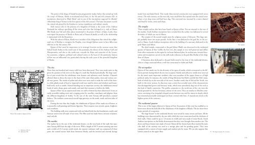
The market<br />
Plan <strong>of</strong> the market at Qaryat al-Faw<br />
7. Ryckmans 509–10.<br />
8. Ryckmans 506.<br />
The site<br />
More than one hundred and twenty wells have been discovered. They were made easier to dig<br />
given the position <strong>of</strong> the town on the edge <strong>of</strong> a wadi that flooded periodically. The large number<br />
<strong>of</strong> pits reveals that the inhabitants were farmers and sedentary stock breeders. Channels<br />
allowed them to direct the water to the heart <strong>of</strong> the oasis where palms, vines and various cereals<br />
were grown. The trunks <strong>of</strong> palms and other trees were used to make the ro<strong>of</strong>s <strong>of</strong> the houses,<br />
while planks made <strong>of</strong> local or imported wood were used for doors and windows and household<br />
tools, such as combs. Animal breeding was an important activity: the inhabitants owned<br />
herds <strong>of</strong> cattle, sheep, goats and camels, and used their manure to fertilize the fields.<br />
Qaryat al-Faw was an unprotected town: no wall or fortress has been discovered. It was an<br />
easily accessible trading town and a staging point for travellers, merchants and pilgrims from<br />
the different kingdoms <strong>of</strong> <strong>Arabia</strong>. To the east <strong>of</strong> the town Tuwaiq cliff provided a natural<br />
defence. The residents constructed several large gateways on the north, south and west sides <strong>of</strong><br />
the town.<br />
During the wars that they fought, the inhabitants <strong>of</strong> Qaryat al-Faw made use <strong>of</strong> horses, as<br />
is attested by wall paintings and bronze figurines. Their weapons were swords, spears, longbows<br />
and crossbows.<br />
The building walls were constructed with sun-baked brick but the foundations, tombs and<br />
funerary towers were all made <strong>of</strong> cut stone. The filler used was made from a mixture <strong>of</strong> plaster,<br />
sand and ash.<br />
The market<br />
The market lay to the east <strong>of</strong> the residential district, on the west bank <strong>of</strong> the wadi that separates<br />
Tuwaiq cliff from the edge <strong>of</strong> the town. With a length <strong>of</strong> 30.75 metres running east-west<br />
and a width <strong>of</strong> 25.2 metres north-south, the massive enclosure wall was composed <strong>of</strong> three<br />
parts: the central section built from limestone blocks, and the internal and external facings<br />
The necropolises<br />
Qaryat al-Faw stands out for the diversity <strong>of</strong> its types <strong>of</strong> tombs, which correspond to the different<br />
periods during which the site was occupied. Family and collective tombs were reserved<br />
for the town’s most important residents, who were members <strong>of</strong> the upper classes or <strong>of</strong> high<br />
political ranks; for instance, the tombs <strong>of</strong> king Mu‘awiya bin Rabi‘a and Ijil ibn H<strong>of</strong>i ‘amm,<br />
both <strong>of</strong> which lay on the west side <strong>of</strong> the town. Another tomb, that <strong>of</strong> Ma‘sad ibn ‘Arsch, was<br />
built in the tower section. Its discovery near a tower has revealed some <strong>of</strong> the characteristics<br />
that distinguished graves and funerary stelae, which were prevalently dug out <strong>of</strong> the rock at<br />
the back <strong>of</strong> family cemeteries. The public cemeteries to the north-east <strong>of</strong> the city were the<br />
burial grounds for the less fortunate citizens <strong>of</strong> the town. They are similar to Muslim cemeteries,<br />
consisting <strong>of</strong> an irregularly shaped terrain between one and five metres in depth, which<br />
has remained practically unchanged nor been covered with lime. A mausoleum stood at the<br />
highest point <strong>of</strong> the cemetery.<br />
The residential quarter<br />
This is one <strong>of</strong> the largest districts in Qaryat al-Faw. Excavation <strong>of</strong> this zone has enabled us to<br />
know more about the daily life <strong>of</strong> the inhabitants <strong>of</strong> the kingdom <strong>of</strong> Kinda. The site knew three<br />
major periods <strong>of</strong> occupation.<br />
The huge houses 9 in the residential district were served by many streets and lanes. All the<br />
buildings were characterized by the care with which they were constructed and the thickness <strong>of</strong><br />
their walls. These could be up to 1.8 metres in width and were made <strong>of</strong> stone blocks. South<br />
<strong>Arabia</strong>n inscriptions on the blocks demonstrate that they were brought from another site. The<br />
doors and house frames were made <strong>of</strong> wood. Almost all the houses had a floor reached by stairs<br />
(the shell <strong>of</strong> the stairway was used as a storage place and for grinding grain). They were<br />
equipped with a system <strong>of</strong> water supply and outdoor pits for waste. We can also suppose that<br />
latrines existed on the upper floor.<br />
9. The largest measure 10 x 3 metres.<br />
The market reconstructed in 3D<br />
314<br />
315