Hydrography of the Russian River Estuary - Sonoma County Water ...
Hydrography of the Russian River Estuary - Sonoma County Water ...
Hydrography of the Russian River Estuary - Sonoma County Water ...

Create successful ePaper yourself
Turn your PDF publications into a flip-book with our unique Google optimized e-Paper software.
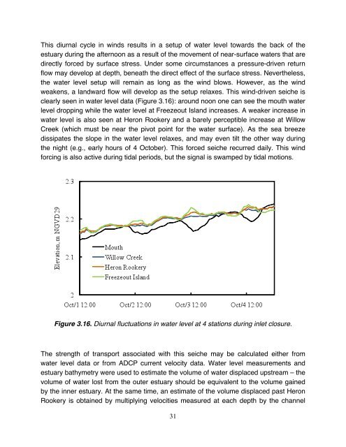
This diurnal cycle in winds results in a setup <strong>of</strong> water level towards <strong>the</strong> back <strong>of</strong> <strong>the</strong><br />
estuary during <strong>the</strong> afternoon as a result <strong>of</strong> <strong>the</strong> movement <strong>of</strong> near-surface waters that are<br />
directly forced by surface stress. Under some circumstances a pressure-driven return<br />
flow may develop at depth, beneath <strong>the</strong> direct effect <strong>of</strong> <strong>the</strong> surface stress. Never<strong>the</strong>less,<br />
<strong>the</strong> water level setup will remain as long as <strong>the</strong> wind blows. However, as <strong>the</strong> wind<br />
weakens, a landward flow will develop as <strong>the</strong> setup relaxes. This wind-driven seiche is<br />
clearly seen in water level data (Figure 3.16): around noon one can see <strong>the</strong> mouth water<br />
level dropping while <strong>the</strong> water level at Freezeout Island increases. A weaker increase in<br />
water level is also seen at Heron Rookery and a barely perceptible increase at Willow<br />
Creek (which must be near <strong>the</strong> pivot point for <strong>the</strong> water surface). As <strong>the</strong> sea breeze<br />
dissipates <strong>the</strong> slope in <strong>the</strong> water level relaxes, and may even tilt <strong>the</strong> o<strong>the</strong>r way during<br />
<strong>the</strong> night (e.g., early hours <strong>of</strong> 4 October). This forced seiche recurred daily. This wind<br />
forcing is also active during tidal periods, but <strong>the</strong> signal is swamped by tidal motions.<br />
Figure 3.16. Diurnal fluctuations in water level at 4 stations during inlet closure.<br />
The strength <strong>of</strong> transport associated with this seiche may be calculated ei<strong>the</strong>r from<br />
water level data or from ADCP current velocity data. <strong>Water</strong> level measurements and<br />
estuary bathymetry were used to estimate <strong>the</strong> volume <strong>of</strong> water displaced upstream – <strong>the</strong><br />
volume <strong>of</strong> water lost from <strong>the</strong> outer estuary should be equivalent to <strong>the</strong> volume gained<br />
by <strong>the</strong> inner estuary. At <strong>the</strong> same time, an estimate <strong>of</strong> <strong>the</strong> volume displaced past Heron<br />
Rookery is obtained by multiplying velocities measured at each depth by <strong>the</strong> channel<br />
31