Local Hazard Mitigation Plan.pdf - Sonoma County Water Agency ...
Local Hazard Mitigation Plan.pdf - Sonoma County Water Agency ...
Local Hazard Mitigation Plan.pdf - Sonoma County Water Agency ...

You also want an ePaper? Increase the reach of your titles
YUMPU automatically turns print PDFs into web optimized ePapers that Google loves.
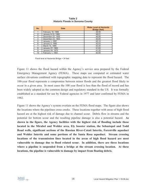
1 February 18, 1986 48.56<br />
2 January 9-10, 1995 48.01<br />
3 December 23, 1955 46.95<br />
4 December 23, 1964 46.85<br />
5 January 1, 1997 45.10<br />
6 January 5, 1966 42.53<br />
7 March 10, 1995 42.24<br />
8 January 27, 1983 41.63<br />
9 January 24, 1970 41.20<br />
10 February 1, 1963 40.95<br />
Flood level at Hacienda Bridge = 34 feet<br />
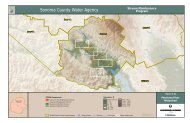
Figure 11 shows the flood hazard within the <strong>Agency</strong>’s service area prepared by the Federal<br />
Emergency Management <strong>Agency</strong> (FEMA). These maps use computed or estimated water<br />
surface elevations combined with topographic mapping data to represent the flood hazard. The<br />
100-year flood represents a compromise between minor floods and the greatest flood likely to<br />
occur in a given area. In most cases the 100 year flood is less than the flood of record and has<br />
been widely adopted as the common design and regulatory standard in the US. It was formally<br />
established as a standard for use by Federal agencies in 1977 and later confirmed by FEMA in<br />
1982.<br />
Figure 11 shows the <strong>Agency</strong>’s system overlain on the FEMA flood maps. The figure also shows<br />
the locations where the pipelines cross creeks. These locations together with areas of high flood<br />
hazard are at the highest risk of damage due to channel scour. Debris flow in streams and the<br />
potential for bottom scour and the resulting pipeline damage is also a potential hazard. As<br />
shown in the figure, the <strong>Agency</strong> facilities with the highest risk of flooding include those<br />
located in the Mirabel and Wohler area, Ely booster station, the Sebastopol and Todd<br />
Road wells, significant sections of the Russian River-Cotati Intertie, Forestville aqueduct<br />
and Wohler Intertie and some portions of the Santa Rosa aqueduct. Stream crossing<br />
locations of the transmission lines located in the areas of high flood hazard are most<br />
vulnerable to damage due to flood related scour. In addition, there are three locations<br />
where a pipeline is suspended from a bridge at the stream crossing location. At these<br />
locations, the pipeline is vulnerable to damage by impact from floating debris.<br />
18 <strong>Local</strong> <strong>Hazard</strong> <strong>Mitigation</strong> <strong>Plan</strong> 1-18-08.doc