Taupo District Flood Hazard Study - Whareroa Stream June 2012
Taupo District Flood Hazard Study - Whareroa Stream June 2012
Taupo District Flood Hazard Study - Whareroa Stream June 2012

Create successful ePaper yourself
Turn your PDF publications into a flip-book with our unique Google optimized e-Paper software.
<strong>Taupo</strong> <strong>District</strong> <strong>Flood</strong> <strong>Hazard</strong> <strong>Study</strong> - <strong>Whareroa</strong> <strong>Stream</strong><br />
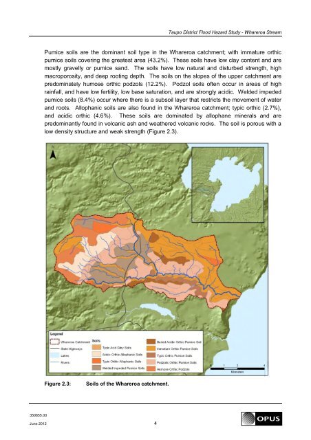
Pumice soils are the dominant soil type in the <strong>Whareroa</strong> catchment; with immature orthic<br />
pumice soils covering the greatest area (43.2%). These soils have low clay content and are<br />
mostly gravelly or pumice sand. The soils have low natural and disturbed strength, high<br />
macroporosity, and deep rooting depth. The soils on the slopes of the upper catchment are<br />
predominately humose orthic podzols (12.2%). Podzol soils often occur in areas of high<br />
rainfall, and have low fertility, low base saturation, and are strongly acidic. Welded impeded<br />
pumice soils (8.4%) occur where there is a subsoil layer that restricts the movement of water<br />
and roots. Allophanic soils are also found in the <strong>Whareroa</strong> catchment; typic orthic (2.7%),<br />
and acidic orthic (4.6%). These soils are dominated by allophane minerals and are<br />
predominantly found in volcanic ash and weathered volcanic rocks. The soil is porous with a<br />
low density structure and weak strength (Figure 2.3).<br />
Figure 2.3:<br />
Soils of the <strong>Whareroa</strong> catchment.<br />
350855.00<br />
<strong>June</strong> <strong>2012</strong> 4