Taupo District Flood Hazard Study - Whareroa Stream June 2012
Taupo District Flood Hazard Study - Whareroa Stream June 2012
Taupo District Flood Hazard Study - Whareroa Stream June 2012

You also want an ePaper? Increase the reach of your titles
YUMPU automatically turns print PDFs into web optimized ePapers that Google loves.
<strong>Taupo</strong> <strong>District</strong> <strong>Flood</strong> <strong>Hazard</strong> <strong>Study</strong> - <strong>Whareroa</strong> <strong>Stream</strong><br />
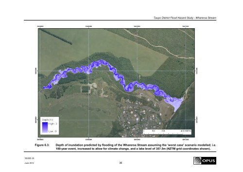
Figure 6.3:<br />
Depth of inundation predicted by flooding of the <strong>Whareroa</strong> <strong>Stream</strong> assuming the ‘worst case’ scenario modelled; i.e.<br />
100-year event, increased to allow for climate change, and a lake level of 357.5m (NZTM grid coordinates shown).<br />
350855.00<br />
<strong>June</strong> <strong>2012</strong> 36