


You also want an ePaper? Increase the reach of your titles
YUMPU automatically turns print PDFs into web optimized ePapers that Google loves.
Continued from previous page<br />
STEP 2 - Get Coordinates for your stations of interest (SOI)<br />
a. If you are in the map view, click on the station name in the list or the<br />
pushpin on the map.<br />
b. On the balloon that appears over the site click on “Get Site Info”.<br />
c. On the left side of the Site Info page click on “Coordinates”. The coordinate<br />
sheet will come up. You should use the Antenna Reference Point<br />
(ARP) values. There are coordinates on the ITRF2000 datum and the<br />
NAD_83_CORS96 datum. The EPOCH being used will be listed. You will<br />
need to copy and paste these coordinates into your processing software<br />
for site position control.<br />
Note: Looking on the list on Figure1, you will see that you can also get<br />
the Data Sheet (ARP Only) which will also have the coordinates in NAD83<br />
(CORS) and State Plane Values. You may want to download this for project<br />
information used in reporting, etc. The SiteLog will show you the receiver and<br />
antenna for the site. The antenna information is usually embedded in the<br />
RINEX file, but you should verify the antenna type.<br />
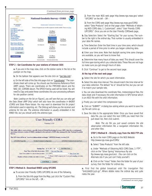
STEP 3 Method A– <strong>Download</strong> RINEX using UFCORS<br />
a. To access User Friendly CORS (UFCORS) do one of the following.<br />
1. From the Site Info page from the Map, just click the “Custom Files<br />
(UFCORS)” link on the left, - OR -<br />
2. From the main NGS web page http://www.ngs.noaa.gov/ select<br />
“UFCORS” on the left – OR -<br />
3. From the CORS web page http://www.ngs.noaa.gov/CORS/<br />
select “Data Products” and on that page under “Methods of obtaining<br />
NGS CORS data, 1. Customized”, select “User Friendly CORS<br />
(UFCORS)”. Once you are on the User Friendly CORSweb page,<br />
b. Day Selection: Select the “Starting Day” for your survey. The number<br />
to the right is the ordinal day. That number is usually embedded in<br />
your data file names.<br />
c. Time Selection: Enter the Start time in your time zone, which should<br />
include a period of time prior to when you began collecting data.<br />
d. Enter your time zone. Note that daylight saving time zone changes<br />
are available, so you will have to know that.<br />
e. Determine how many hours of data you need. This should cover the<br />
full time span during which you collected data. These files are not huge<br />
so make sure you get enough hours of data.<br />
f. Click “Continue” to get to the second input page.<br />
At the top of the next web page:<br />
g. Select the site for which you want information.<br />
h. Select the data time interval. This should match the time interval for<br />
your data collection. The default “As is” should be fine, but you can set<br />
it to match your sample rate.<br />
i. You can also download the coordinate files, meteorological files, the<br />
data sheet and if necessary the orbit information in SP3 format which<br />
is an ASCII file with the orbit information.<br />
j. Finally you can select the compression type.<br />
k. Click on “SUBMIT”. A dialog box asking where you want to save the<br />
zip file will come up.<br />
l. Save the data to the appropriate folder. Once you have saved that<br />
data file, you can select the next CORS you need from the<br />
pull-down list, then click submit.<br />
Note: The zip file you just saved contains the site<br />
observation information file, a navigation information file,<br />
and other files.<br />
STEP 3 Method B – Directly copy from the NGS FTP site<br />
a. Go to the main CORS page on the NGS Website<br />
http://www.ngs.noaa.gov/CORS/<br />
b. Select “Data Products” from the left side.<br />
c. Under “Methods of Obtaining NGS CORS Date, 3. FTP”,<br />
click on the “Silver Spring” Anonymous ftp site<br />
ftp://www.ngs.noaa.gov/cors/ . (You can click on the<br />
Alternate site if you just can’t help yourself.)<br />
d. Click on the “rinex/” folder, then the folder for year of your<br />
survey, then the folder for ordinal day.<br />
e. First find the global broadcast orbit file (navigation file)<br />
“brdc[ddd]0.[yy]n.gz”, Where dddde notes the ordinal day and yyde<br />
notes the year.<br />
Continued on next page<br />
Fall 2011<br />
37


