to view the Affordable Housing Plan - Town of North Andover
to view the Affordable Housing Plan - Town of North Andover
to view the Affordable Housing Plan - Town of North Andover

You also want an ePaper? Increase the reach of your titles
YUMPU automatically turns print PDFs into web optimized ePapers that Google loves.
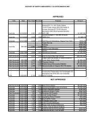
his<strong>to</strong>ry highlighted in <strong>the</strong> table below is supportive <strong>of</strong> <strong>the</strong> increased demand for housing due in part<br />
<strong>to</strong> decades <strong>of</strong> population growth in <strong>the</strong> community, availability <strong>of</strong> land and <strong>the</strong> attractiveness <strong>of</strong><br />
<strong>North</strong> <strong>Andover</strong> <strong>to</strong> families. Land use change is important <strong>to</strong> analyze because it illustrates <strong>the</strong> type<br />
and level <strong>of</strong> growth in a community over time. O<strong>the</strong>r municipalities in <strong>the</strong> <strong>North</strong> <strong>Andover</strong> region <strong>of</strong><br />
Massachusetts also experienced a significant decline in open land <strong>to</strong> make room for additional<br />
residential growth.<br />
Table: Land Use Change in Acres, <strong>North</strong> <strong>Andover</strong> 1971-1999<br />
Change % Change<br />
1971 1985 1999 1971-1999 1971-1999<br />
Agriculture 1,675.04 1,329.57 1,050.27 -624.77 -37.3%<br />
Forest 10,605.19 9,501.78 8,628.15 -1,977.04 -18.6%<br />
Recreation & Urban Open Space 459.39 573.63 497.84 38.45 8.4%<br />
Multifamily Residential 162.71 235.17 259.72 97.01 59.6%<br />
Moderate-Density Residential (1/4 - 1/2 acre) 1,229.77 1,798.86 2,307.46 1,077.69 87.6%<br />
Low-Density Residential (> 1/2 acre) 1,188.98 1,688.03 2,379.29 1,190.31 100.1%<br />
Commercial 178.83 254.29 276.25 97.42 54.5%<br />
Industrial 273.16 368.14 446.20 173.04 63.3%<br />
Transportation 295.63 300.96 310.43 14.81 5.0%<br />
Open Land, Mining & O<strong>the</strong>r 510.88 524.22 424.21 -86.67 -17.0%<br />
Wetlands 297.97 310.85 325.24 27.27 9.2%<br />
Water 746.84 738.90 719.33 -27.51 -3.7%<br />
Total 17,624.40 17,624.40 17,624.40<br />
Source: MassGIS<br />
III B - DEMOGRAPHICS<br />
<strong>North</strong> <strong>Andover</strong> is conveniently located in <strong>the</strong> Merrimack Valley region <strong>of</strong> Massachusetts and is<br />
bounded by <strong>the</strong> communities <strong>of</strong> <strong>Andover</strong>, Haverhill, Lawrence, <strong>North</strong> Reading, Boxford,<br />
Methuen and Boxford. Residents <strong>of</strong> <strong>North</strong> <strong>Andover</strong> are fortunate <strong>to</strong> live in a <strong>to</strong>wn that has a<br />
large amount <strong>of</strong> open space, access <strong>to</strong> several state highways and major interstates,<br />
neighborhoods that exude character and charm and an excellent school system.<br />
Today, <strong>North</strong> <strong>Andover</strong> is facing a considerable amount <strong>of</strong> growth in both commercial and<br />
residential districts. Coupled with this growth is a strong desire among local residents <strong>to</strong> retain<br />
<strong>the</strong> sense <strong>of</strong> community and family oriented <strong>to</strong>wn feel that currently exists.<br />
Population<br />
During <strong>the</strong> past decade, 1990-2000, <strong>North</strong> <strong>Andover</strong>’s overall population increased by approximately<br />
20%, which is significantly higher than both <strong>the</strong> Essex County and State population percentage<br />
increases for <strong>the</strong> same period. In comparison, only Boxford, Middle<strong>to</strong>n and Wilming<strong>to</strong>n saw higher<br />
population increases for <strong>the</strong> same time period. Table 1 below highlights his<strong>to</strong>ric and projected<br />
population information for <strong>North</strong> <strong>Andover</strong> and <strong>the</strong> surrounding communities. Currently, MISER<br />
has projected that <strong>the</strong>re will be ano<strong>the</strong>r 10% increase in <strong>North</strong> <strong>Andover</strong>’s overall population<br />
between 2000–2010, which o<strong>the</strong>r than Middle<strong>to</strong>n is <strong>the</strong> highest increase among neighboring <strong>to</strong>wns<br />
projected.<br />
<strong>North</strong> <strong>Andover</strong> <strong>Affordable</strong> <strong>Housing</strong> <strong>Plan</strong><br />
Page 10 <strong>of</strong> 49