MIRRABOOKA Local Area Plan - City of Stirling
MIRRABOOKA Local Area Plan - City of Stirling
MIRRABOOKA Local Area Plan - City of Stirling

You also want an ePaper? Increase the reach of your titles
YUMPU automatically turns print PDFs into web optimized ePapers that Google loves.
areas and ecological linkages. (It is <strong>of</strong> note that bushland within the<br />
Alexander Drive and Beach Road median strips is managed by the<br />
<strong>City</strong> <strong>of</strong> Swan and <strong>City</strong> <strong>of</strong> Wanneroo respectively and is thus beyond<br />
<strong>of</strong> the direct control <strong>of</strong> the <strong>City</strong> <strong>of</strong> <strong>Stirling</strong>).<br />
occurring over these areas. Special development controls apply to<br />
activities and land uses regarding underground water. The<br />
preservation <strong>of</strong> natural vegetation also invariably helps to maintain<br />
the under ground water quality.<br />
Public Open Space<br />
There are 20 parks and reserves across the Mirrabooka <strong>Local</strong> <strong>Area</strong><br />
that provide for diverse functions. These spaces include large active<br />
recreation reserves such as sports fields, large and small areas <strong>of</strong><br />
natural bushland, community social spaces and smaller parks<br />
popular for children’s play, dog walking and other passive<br />
recreation. The size, use and quality <strong>of</strong> these spaces vary from<br />
reserve to reserve, as does the environmental and social value <strong>of</strong><br />
each space.<br />
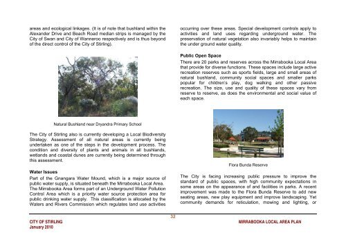
Natural Bushland near Dryandra Primary School<br />
The <strong>City</strong> <strong>of</strong> <strong>Stirling</strong> also is currently developing a <strong>Local</strong> Biodiversity<br />
Strategy. Assessment <strong>of</strong> all natural areas is currently being<br />
undertaken as one <strong>of</strong> the steps in the development process. The<br />
condition and diversity <strong>of</strong> plants and animals in all bushlands,<br />
wetlands and coastal dunes are currently being determined through<br />
this assessment.<br />
Water Issues<br />
Part <strong>of</strong> the Gnangara Water Mound, which is a major source <strong>of</strong><br />
public water supply, is situated beneath the Mirrabooka <strong>Local</strong> <strong>Area</strong>.<br />
The Mirrabooka <strong>Area</strong> forms part <strong>of</strong> an Underground Water Pollution<br />
Control <strong>Area</strong> which is a priority water source protection area for<br />
public drinking water supply. This classification is allocated by the<br />
Waters and Rivers Commission which regulates land use activities<br />
Flora Bunda Reserve<br />
The <strong>City</strong> is facing increasing public pressure to improve the<br />
standard <strong>of</strong> public spaces, with high community expectations in<br />
some areas on the appearance <strong>of</strong> and facilities in parks. A recent<br />
improvement was made to the Flora Bunda Reserve to add new<br />
seating areas, new play equipment and improve landscaping. Yet<br />
community demands for reticulation, mowing and lighting, or<br />
32<br />
CITY OF STIRLING <strong>MIRRABOOKA</strong> LOCAL AREA PLAN<br />
January 2010