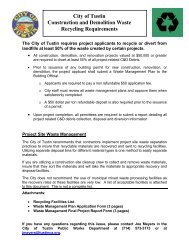
j - City of Tustin
j - City of Tustin
j - City of Tustin

Create successful ePaper yourself
Turn your PDF publications into a flip-book with our unique Google optimized e-Paper software.
-·---·'·-r----<br />
-:'"\<br />
, I<br />
j<br />
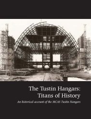
FINAL ENVIRONMENTAL IMPACT STATEMENT (FEIS)/<br />
FINAL ENVIRONMENTAL IMPACT REPORT (FEIR)<br />
FOR THE DISPOSAL AND REUSE OF<br />
MARINE CORP AIR STATION (MCAS) TUSTIN<br />
TUSTIN, CALIFORNIA<br />
IRVINE, CALIFOAA'IA<br />
:::<br />
: ..<br />
Lead Agency for the EIS:<br />
Lead Agency for the EIR:<br />
Title <strong>of</strong> Proposed Action:<br />
Affected Jurisdictions:<br />
Designation:<br />
State Clearinghouse #:<br />
Department <strong>of</strong> the Navy<br />
<strong>City</strong> <strong>of</strong> <strong>Tustin</strong><br />
Disposal and Reuse <strong>of</strong>MCAS <strong>Tustin</strong><br />
<strong>City</strong> <strong>of</strong> <strong>Tustin</strong>, California; <strong>City</strong> <strong>of</strong> Irvine, California<br />
Final EIS/EIR Submitted Pursuant to 42 U.S.C. 4332(2)(C), Public<br />
Resources Code 21000 et seq., and 14 California Code Regulations 15000<br />
et seq.<br />
94071005<br />
,-"<br />
.. '<br />
ABSTRACT<br />
;::.<br />
Pursuant to the Defense Base Closure and Realignment Act <strong>of</strong> 1990, Public Law 101-510, Title XXIX, as<br />
implemented by the base closure process <strong>of</strong>1991 and 1993, MCAS <strong>Tustin</strong> was closed on July 3, 1999. This<br />
joint EISIEIR has been prepared in accordance with National Environmental Policy Act (NEP A) and<br />
California Environmental Quality Act (CEQA) statutes and guidelines to support disposal <strong>of</strong>MCAS <strong>Tustin</strong><br />
and the subsequent reuse <strong>of</strong> those properties and other adjacent properties by the <strong>City</strong> <strong>of</strong> <strong>Tustin</strong> and the <strong>City</strong><br />
<strong>of</strong> Irvine. The NEPA federal action evaluated in this EISIEIR is the disposal <strong>of</strong> U.S. Marine Corps property.<br />
The local CEQA project evaluated is the proposed reuse <strong>of</strong> the entire reuse plan area.<br />
". i<br />
The EISIEIR evaluates three reuse alternatives: Alternative 1 - LRA Reuse Alternative; Alternative 2 -<br />
Arterial Grid PatternlNo CorelHigh Residential; and Alternative 3 - Arterial Loop PatternlReserve AreaILow<br />
Residential. Also evaluated is the No Action Alternative, in which the Marine Corps would retain ownership<br />
<strong>of</strong> MCAS <strong>Tustin</strong>, which would be under caretaker status. This EISIEIR analyzes potential environmental<br />
impacts relating to land use; socioeconomics; utilities; public services and facilities; aesthetics; cultural and<br />
paleontological resources; biological resources; agricultural resources; soils and geology; water resources;<br />
hazardous wastes, substances, and materials; traffic/circulation; air quality; and noise. Potentially significant<br />
and not mitigable impacts are related to conversion <strong>of</strong> Farmland, elimination <strong>of</strong> two historic districts,<br />
demolition <strong>of</strong> historic blimp hangars (possibly one or both hangars), air quality emissions, and<br />
traffic/circulation.<br />
Comments should be sent to Dana Ogdon, Senior Project Manager, <strong>City</strong> <strong>of</strong> <strong>Tustin</strong>, 300 Centennial Way,<br />
<strong>Tustin</strong>, CA 92780. Telephone: (714) 573-3116 and Fax: (714) 573-3113.<br />
i ,:',<br />
j ,',.
This page intentionally left blank.<br />
" ; . -.~ "._',.,. 'T- . ,
Preface<br />
--,<br />
:.: j<br />
"<br />
',':1<br />
PREFACE<br />
MCAS TUSTIN EISIEIR<br />
.. :<br />
,I<br />
:1<br />
:. I<br />
This document is a revised Draft Environmental Impact StatementlEnvironmental Impact Report<br />
(EISIEIR) addressing the disposal and reuse <strong>of</strong> Marine Corps Air Station (MCAS) <strong>Tustin</strong>. The initial<br />
Draft EISIEIR was circulated for a 60-day public review period which ended in March 1998. Comments<br />
on that docmnent indicated the need to expand the traffic circulation study area and to provide<br />
supplementary analyses for the issues <strong>of</strong> regional growth, schools, biology, water quality, air quality,<br />
utilities, public services, noise, and hazardous materials. Given the amount <strong>of</strong> new information to be<br />
provided, the U.S. Marine Corps and the <strong>City</strong> <strong>of</strong> <strong>Tustin</strong> elected to re-circulate the entire EISIEIR as a<br />
revised docmnent.<br />
In accordance with the implementing guidelines <strong>of</strong> the California Environmental Quality Act (CEQA),<br />
when an entire EIR is re-circulatecl, the lead agency ''need not respond to those comments received during<br />
the earlier circulation period" and "may require that reviewers submit new comments" (Cal. Code Regs.,<br />
Title 14, § 15088.5(f)(1)). Additionally, the lead agency shall, "in the revised EIR, or by an attachment<br />
to the revised EIR, summarize the revisions made to the previously circulated draft EIR" (Cal. Code<br />
Regs., Title 14, § 15088.5 (2)(g)). The federal National Environmental Policy Act (NEP A) has no similar<br />
guidance regarding re-circulation. Consistent with state law and implementing regulations, a smnmary<br />
<strong>of</strong> revisions to the initial Draft EISIEIR is provided in Appendix D to this revised EISIEIR. Interested<br />
parties are requested to submit new comments on this docmnent.<br />
This recirculated EISIEIR has been prepared based on technical and supporting information that is<br />
publicly available. Docmnents available at the <strong>Tustin</strong> Public Library, 345 East Main Street, include<br />
the MCAS <strong>Tustin</strong> Specific PlanlReuse Plan (<strong>City</strong> <strong>of</strong> <strong>Tustin</strong> 1996b) and the MCAS <strong>Tustin</strong> Specific<br />
Plan/Reuse Plan E"ata (<strong>City</strong> <strong>of</strong> <strong>Tustin</strong> 1998). Other technical studies supporting individual issue<br />
analyses are available to the public at the <strong>Tustin</strong> <strong>City</strong> Hall, 300 Centennial Way. The complete list<br />
<strong>of</strong> source materials used in the preparation <strong>of</strong> this environmental docmnent is provided in Chapter<br />
10.<br />
:. ,<br />
Because this document has been prepared to satisfY federal and state environmental law, two military<br />
organizations (Navy and Marine Corps), as well as several state and local jurisdictions, it contains<br />
numerous acronyms and terms that may be unfamiliar to the reader. A complete list <strong>of</strong> acronyms is<br />
providedirnmediately following the Table <strong>of</strong> Contents, and a glossary/index is provided in Appendix A.<br />
'.<br />
'i',<br />
--,<br />
,.".::<br />
::.: ;<br />
,"<br />
MCAS <strong>Tustin</strong> EIS/EIR<br />
99"()JIP,qace 111/8199
Preface<br />
This page intentionally left blank.<br />
MCAS <strong>Tustin</strong> EISIEIR<br />
99-011Preface lJl/8199
Table <strong>of</strong> Contents<br />
VOLUMEl<br />
TABLE OF CONTENTS<br />
Section<br />
J<br />
j<br />
,:~.~<br />
..<br />
.,<br />
i<br />
,<br />
:::J<br />
• '0<br />
j<br />
[",-:\1<br />
I<br />
~: :: .<br />
"<br />
.~.,<br />
,: :~<br />
E)[EClJTrvES~,( .............. , .................................... ES-1<br />
ES-l Introduction ................................................... ES-l<br />
ES-2 Purpose <strong>of</strong> and Need for the Action ................................. ES-4<br />
ES-3 Use <strong>of</strong> an Integrated Document .................................... ES-6<br />
ES-4 Related Studies ................................................. ES-8<br />
ES-5 Public Involvement Process ....................................... ES-8<br />
ES-6 Navy Disposal Actions .......................................... ES-lO<br />
ES-7 <strong>City</strong> <strong>of</strong> <strong>Tustin</strong> Reuse Alternatives ................................. ES-ll<br />
ES-8 Affected Environment .......................................... ES-18<br />
ES-9 Environmental Consequences .................................... ES-18<br />
ES-I0 Cumulative Impacts " .......................................... ES-19<br />
ES-ll Other NEP AlCEQA Considerations ............................... ES-28<br />
ES-12 LRA Reuse Alternative Implementing Actions ....................... ES-31<br />
ES-13 Agency Coordination ........................................... ES-36<br />
CHAPTER 1.0-PURPOSE AND NEED ........................................ 1-1<br />
1.1 Federal Action ............ ~ ..................................... 1-1<br />
1.2 Local Action. . . . . . . . . . . . . . . . . . . . . . . . . . . . . . . . . . . . . . . . . . . . . . . . . . .. 1-4<br />
1.3 Overview <strong>of</strong>MCAS <strong>Tustin</strong> ........................................ 1-8<br />
1.4 Overview <strong>of</strong> Local Jurisdictions ................................... 1-14<br />
1.5 Use <strong>of</strong> an Integrated Document " ................................. , 1-16<br />
1.6 Document Organization . . . . . . . . . . . . . . . . . . . . . . . . . . . . . . . . . . . . . . . . .. 1-18<br />
1.7 Related Studies .... " ........... " ...... '" ................... ,. 1-21<br />
1.8 Public Involvement Process ....................................... 1-22<br />
CHAPTER2.0-ALTERNATrvES CONSIDERED ................................ 2-1<br />
2.1 Disposal Alternatives ............................................. 2-1<br />
2.2 Reuse Alternatives ............................................... 2-2<br />
2.3 Alternatives Eliminated from Detailed Review ........................ 2-10<br />
2.4 Detailed Description <strong>of</strong> Reuse Alternatives ........................... 2-12<br />
2.5 Environmentally PreferablelEnvironmentally Superior Alternative ........ 2-38<br />
2.6 Permit Requirements and Related Coordination ....................... 2-44<br />
2.7 Comparison <strong>of</strong> Alternatives Impacts and Mitigation .................... 2-44<br />
MCAS <strong>Tustin</strong> EIS/EIR<br />
99·0Jlsecl.1« 11118199<br />
Page i
Table <strong>of</strong> Contents<br />
VOLUMEl<br />
TABLE OF CONTENTS<br />
Section<br />
CHAPTER 3.0 - AFFECTED ENVIRONMENT ................................... 3-1<br />
3.1 Land Use ...................................................... 3-3<br />
3.2 Socioeconomics ................................................ 3-18<br />
3.3 Utilities ....................................................... 3-35<br />
3.4 Public Services and Facilities ..................................... 3-47<br />
3.5 Aesthetics ..................................................... 3-58<br />
3.6 Cultural and Paleontological Resources ............................. 3-68<br />
3.7 Biological Resources ....... , .................................... 3-75<br />
3.8 Agricultural Resources ........................................... 3-83<br />
3.9 Soils and Geology .............................................. 3-88<br />
3.10 Water Resources ............................................... 3-98<br />
3.11 Hazardous Wastes, Substances, and Materials ....................... 3-106<br />
3.12 Traffic/Circulation ............................................. 3-118<br />
3.13 Air Quality ................................................... 3-143<br />
3.14 Noise ....................................................... 3-154<br />
CHAPTER 4.0 - ENVIRONMENTAL CONSEQUENCES .......................... 4-1<br />
4.1 Land Use ...................................................... 4-3<br />
4.2 Socioeconomics ................................................ 4-14<br />
4.3 Utilities ....................................................... 4-32<br />
4.4 Public Services and Facilities ..................................... 4-56<br />
4.5 Aesthetics ..................................................... 4-81<br />
4.6 Cultural and Paleontological Resources ............................. 4-93<br />
4.7 Biological Resources ........................................... 4-103<br />
4.8 Agricultural Resources .......................................... 4-109<br />
4.9 Soils and Geology ............................................. 4-115<br />
4.10 Water Resources .............................................. 4-124<br />
4.11 Hazardous Wastes, Substances, and Materials ....................... 4-130<br />
4.12 Traffic/Circulation ............................................. 4-139<br />
4.13 Air Quality .................. :................................ 4-207<br />
4.14 Noise ....................................................... 4-231<br />
CHAPTER 5.0 - CUMULATIVE PROJECTS AND IMPACTS ....................... 5-1<br />
5.1 Description <strong>of</strong> General Plan and Regional Plans ....................... 5-2<br />
5.2 Analysis <strong>of</strong> Cumulative hnpacts .................................... 5-4<br />
Page ii<br />
MCAS <strong>Tustin</strong> EISIEIR<br />
99-OJl1ect.lOC 11//7/99
· :<br />
Table <strong>of</strong> Contents<br />
VOLUMEl<br />
TABLE OF CONTENTS<br />
Section<br />
CHAPTER 6.0 - OTHER CONSIDERATIONS REQUIRED BY NEPAlCEQA .......... 6-1<br />
6.1 Significant Unavoidable Adverse Effects ............................. 6-1<br />
6.2 Short-term Uses and Long-tenn Productivity .......................... 6-3<br />
6.3 Irreversible/irretrievable Commitments <strong>of</strong> Resources .................... 6-3<br />
6.4 Growth-inducing Impacts ......................................... 6-4<br />
6.5 Effects Found Not to Be Significant ......... ; ....................... 6-6<br />
6.6 Protection <strong>of</strong> Children from Environmental Health Risks and Safety Risks . .. 6-6<br />
6.7 Environmental Justice ............................................ 6-7<br />
CHAPTER 7.0 - LRA REUSE ALTERNATIVE IMPLEMENTING ACTIONS .......... 7-1<br />
7.1 Description <strong>of</strong> Implementing Actions ................................ 7-1<br />
7.2 Environmental Consequences <strong>of</strong> Implementing Actions ................. 7-16<br />
7.3 Cumulative Impacts ............................................. 7-43<br />
7.4 Other CEQA Sections ........................................... 7-44<br />
.. "::\ ...<br />
:{<br />
i.:J<br />
CHAPTER 8.0 - CONSULTATION AND COORDINATION ........................ 8-1<br />
8.1 Agency Coordination . . . . . . . . . . . . . . . . . . . . . . . . . . . . . . . . . . . . . . . . . . . . . 8-1<br />
8.2 Public Coordination .............................................. 8-5<br />
CHAPTER 9.0 - LIST OF PREP ARERS AND CONTRIBUTORS .................... 9-1<br />
CHAPTER 10.0 - REFERENCES AND PERSONS CONTACTED ................... 10-1<br />
10.1 References. . . . . . . . . . . . . . . . . . . . . . . . . . . . . . . . . . . . . . . . . . . . . . . . . . .. 10-1<br />
10.2 Persons Contacted ............................................. 10-14<br />
:::: CHAPTER 11.0 - EISIEIR DISTRIBUTION AND NOTIFICATION LIST ............. 11-1<br />
COMMENTS AND RESPONSES mound Separately in Volume 2)<br />
APPENDICES<br />
A GlossarylIndex<br />
B Overview <strong>of</strong> Federal and State Disposal Laws and Regulations<br />
C Notice <strong>of</strong> Intent, Notice <strong>of</strong> Preparation (with Distribution List), Supplementary Notice <strong>of</strong> Intent<br />
D Summary <strong>of</strong> Revisions Made to the Previously Circulated Draft EIS/EIR<br />
E Supporting Correspondence/Infonnation<br />
F Traffic Citettlation Technical Report (Botmd Separately in Volume 2)<br />
Q Supplementary Biological Infonnation ...<br />
H Memorandmn <strong>of</strong> Agreement Regarding Historic Resources<br />
MCAS <strong>Tustin</strong> EISIEIR<br />
99-0llsecl.lt)C JJ//7/99<br />
Page iii
Table <strong>of</strong> Contents<br />
VOLUMEl<br />
LIST OF FIGURES<br />
Figure<br />
ES-l<br />
ES-2<br />
ES-3<br />
ES-4<br />
ES-5<br />
ES-6<br />
ES-7<br />
1-1<br />
1-2<br />
1-3<br />
1-4<br />
2-1<br />
2-2<br />
2-3<br />
3.1-1<br />
3.1-2<br />
3.1-3<br />
3.1-4<br />
3.2-1<br />
3.2-2<br />
3.3-1<br />
3.4-1<br />
3.4-2<br />
3.4-3<br />
3.5-1<br />
3.5-2<br />
3.6-1<br />
3.7-1<br />
3.8-1<br />
3.8-2<br />
3.9-1<br />
3.10-1<br />
3.11-1<br />
3.12-1<br />
3.12-2<br />
Page iv<br />
Regional Map ...................................................... ES-2<br />
Vicinity Map ....................................................... ES-3<br />
Reuse Plan Area .................................................... ES-5<br />
Existing Facilities .................................................. ES-12<br />
Alternative 1 LRA Reuse Alternative ................................... ES-13<br />
Alternative 2 Arterial Grid Pattem/No CorelHigh Residential ................ ES-14<br />
Alternative 3 Arterial Loop PattemlReserve AreaILow Residential ........... ES-15<br />
Regional Map ....................................................... 1-2<br />
VlclmtyMap ........................................................ 1-3<br />
Reuse Plan Area ..................................................... 1-5<br />
Existing Facilities ................................................... 1-11<br />
Alternative 1 LRA Reuse Alternative .................................... 2-16<br />
Alternative 2 Arterial Grid Pattem/No CorelHigh Residential ................. 2-25<br />
Alternative 3 Arterial Loop PattemlReservelLow Residential ................. 2-33<br />
Existing Surrounding Land Uses ........................................ 3-6<br />
General Plan Designations ............................................. 3-8<br />
Zoning Categories . . . . . . . . . . . . . . . . . . . . . . . . . . . . . . . . . . . . . . . . . . . . . . . . . . . 3-10<br />
Land Use Restrictions Related to Air Operations .......................... 3-15<br />
Census Tracts ...................................................... 3-20<br />
<strong>City</strong> Boundaries ..................................................... 3-21<br />
Existing Drainage Channels and Flood Zone . . . . . . . . . . . . . . . . . . . . . . . . . . . . . . 3-41<br />
Boundaries <strong>of</strong> School Districts ......................................... 3-49<br />
Existing Parks and Recreational Facilities ................................ 3-52<br />
Existing Bikeways ................................................... 3-54<br />
Site Photographs .................................................... 3-60<br />
Site Photographs .................................................... 3-61<br />
Discontiguous Historic District ......................................... 3-73<br />
Biological Resources ................................................ 3-78<br />
Important Farmlands ................................................. 3-84<br />
Farmland Conversion Impact Rating 3-86<br />
Active Faults ....................................................... 3-93<br />
Orange County Water District Groundwater Basins ......................... 3-99<br />
IRP and MDA Sites <strong>of</strong> Concern and OUs ................................ 3-109<br />
Traffic Circulation Study Area ........................................ 3-119<br />
Existing (1997-1998) MCAS <strong>Tustin</strong> Roadway Network .................... 3-121<br />
MCAS <strong>Tustin</strong> EISIEIR<br />
99-O]lsecl.IQC 11117/99
Table <strong>of</strong> Contents<br />
VOLUMEl<br />
LIST OF FIGURES<br />
Figure<br />
'.:."<br />
"::.<br />
i ~.' •<br />
:1<br />
3.12-3<br />
3.12-4<br />
3.12-5<br />
3.12-6<br />
3.12-7<br />
3.12-8<br />
3.13-1<br />
3.14-1<br />
4.12-1<br />
4.12-2<br />
4.12-3<br />
4.12-4<br />
4.12-5<br />
4.12-6<br />
4.12-7<br />
4.12-8<br />
4.12-9<br />
4.12-10<br />
4.12-11<br />
4.12-12<br />
4.12-13<br />
4.12-14<br />
4.12-15<br />
6-1<br />
7-1<br />
Existing (1997-1998) Roadway Network ................................ 3-124<br />
Committed Circulation System Improvements ............................ 3-126<br />
2005 Without Reuse Roadways and Intersection Operations ................. 3-134<br />
2020 Without Reuse Roadways and Intersection Operations ................. 3-136<br />
Existing Bikeways .................................................. 3-140<br />
Orange County Master Plan <strong>of</strong> Bikeways ................................ 3-142<br />
South Coast Air Basin . . . . . . . . . . . . . . . . . . . . . . . . . . . . . . . . . . . . . . . . . . . . . . . 3-144<br />
Baseline Aircraft and Traffic Noise Contours ............................ 3-162<br />
Alternative 1 Circulation System ...................................... 4-142<br />
Alternative 1 2020 Trip Distribution ................................... 4-143<br />
Alternative 1 Plus Existing Impacted Intersections ........................ 4-146<br />
Alternative 1 2005 Impacted Intersections ............................... 4-149<br />
Alternative 1 2020 Impacted Intersections ............................... 4-152<br />
Alternative 2 Circulation System ...................................... 4-165<br />
Alternative 2 2020 Trip Distribution ................................... 4-167<br />
Alternative 2 Plus Existing Impacted Intersections ........................ 4-168<br />
Alternative 2 2005 Impacted Intersections ............................... 4-169<br />
Alternative 2 2020 Impacted Intersections ............................... 4-173<br />
Alternative 3 Circulation System ...................................... 4-186<br />
Alternative 32020 Trip Distribution ................................... 4-187<br />
Alternative 3 Plus Existing Impacted Intersections ........................ 4-188<br />
Alternative 3 2005 Impacted Intersections .............................. , 4-192<br />
Alternative 3 2020 Impacted Intersections ............................... 4-194<br />
Census Tracts within One Mile <strong>of</strong> Project Area ............................ 6-10<br />
Neighborhoods ....................................................... 7-4<br />
MCAS <strong>Tustin</strong> EISIEIR<br />
99-011s«1.1« } J/J8199<br />
Page v
Table <strong>of</strong> Contents<br />
VOLUMEl<br />
LIST OF TABLES<br />
ES-l Reuse Plan Area Approximate Acreage by Jurisdiction .................... ES-6<br />
ES-2 Summary Comparison <strong>of</strong> Land Development and<br />
Buildout Characteristics <strong>of</strong> Alternatives ............................... ES-17<br />
ES-3 Summary <strong>of</strong> Potential Significant Environmental<br />
Consequences and Mitigation Measures ............................... ES-20<br />
ES-4 Alternative 1 and LRA Reuse Alternative Implementing Actions<br />
Comparison <strong>of</strong> Potentially Significant Environmental<br />
Consequences and Mitigation Measures ............................... ES-33<br />
1-1 Reuse Plan Area Approximate Acreage by Jurisdiction ..................... 1-7<br />
2-1 Summary <strong>of</strong> Results from November 1992 Community Opinion Survey ........ 2-3<br />
2-2 Proposals for Reuse <strong>of</strong> MCAS <strong>Tustin</strong> Acted Upon By the Task Force<br />
in December 1993 .................................................. 2-5<br />
2-3 Notice <strong>of</strong> Interests Incorporated into Reuse Plan ........................... 2-9<br />
2-4 Major Components <strong>of</strong> Alternatives .................................... 2-13<br />
2-5 Summary Comparison <strong>of</strong> Land Development and<br />
Buildout Characteristics <strong>of</strong> Alternatives ................................ 2-14<br />
2-6 Alternative 1 Buildout Potential ...................................... 2-17<br />
2-7 Alternative 1 Buildout Characteristics .................................. 2-21<br />
2-8 Alternative 1 Anticipated Development Phasing .......................... 2-23<br />
2-9 Alternative 2 Buildout Potential ...................................... 2-24<br />
2-10 Alternative 2 Buildout Characteristics .................................. 2-29<br />
2-11 Alternative 2 Anticipated Development Phasing .......................... 2-30<br />
2-12 Alternative 3 Buildout Potential ...................................... 2-33<br />
2-13 Alternative 3 Buildout Characteristics .................................. 2-36<br />
2-14<br />
2-15<br />
2-16<br />
2-17<br />
3-1<br />
3.2-1<br />
3.2-2<br />
Alternative 3 Anticipated Development Phasing .......................... 2-37<br />
Key Differentiating Factors Between Alternatives ........................ 2-41<br />
Permits or Actions Potentially Required ................................ 2-45<br />
Summary <strong>of</strong> Potential Significant Environmental Consequences<br />
and Mitigation Measures ............................................ 2-47<br />
Environmental Issues and Region <strong>of</strong> Influence ............................ 3-1<br />
1990 Population, Race, and Ethnicity<br />
Census Tracts Contiguous with Reuse Plan Area ......................... 3-23<br />
1990 Population, Race, and Ethnicity by Contiguous Census<br />
Tract Area, Cities, County, and State ................................... 3-23<br />
! :<br />
Page vi<br />
MCAS <strong>Tustin</strong> EISIEIR<br />
99-OJ'Is«t.lOC J /117/99
l ,<br />
~.1<br />
.1<br />
.• 1<br />
VOLUMEl<br />
LIST OF TABLES<br />
Table <strong>of</strong> Contents<br />
n<br />
f::·}<br />
.'<br />
.'<br />
3.2-3<br />
3.2-4<br />
3.2-5<br />
3.2-6<br />
3.2-7<br />
3.2-8<br />
3.2-9<br />
3.2-10<br />
3.2-11<br />
3.2-12<br />
3.2-13<br />
3.2-14<br />
3.2-15<br />
3.7-1<br />
3.8-1<br />
3.9-1<br />
3.9-2<br />
3.12-1<br />
3.12-2<br />
3.12-3<br />
3.12-4<br />
3.12-5<br />
3.12-6<br />
3.12-7<br />
3.12-8<br />
3.12-9<br />
1990 Population, Race, and Ethnicity by Percent <strong>of</strong> Total Population<br />
by Contiguous Census Tract Area and Cities, County, and State ............. 3-24<br />
1990 and 1998 Population Estimates, Cities Contiguous with Reuse Plan Area . 3-25<br />
Population <strong>of</strong> Contiguous Census Tracts, Cities, and Orange County ......... 3-26<br />
1990 Housing and Housing Occupancy<br />
Census Tracts Contiguous with Reuse Plan Area ......................... 3-26<br />
1990 Housing and Housing Occupancy<br />
Cities Contiguous with Reuse Plan Area and Orange County ................ 3-26<br />
1990 and 1998 Housing Estimates<br />
Cities Contiguous with Reuse Plan Area and Orange County ................ 3-27<br />
Housing Units, Contiguous Census Tracts, Cities, and Orange County ........ 3-29<br />
1990 Total Employment (Civilian and Armed Forces)<br />
Census Tracts Contiguous with the Reuse Plan Area ...................... 3-29<br />
1990 Total Employment (Civilian and Armed Forces)<br />
Contiguous Census Tracts, Cities, and Orange County ..................... 3-29<br />
Employment, Contiguous Census Tracts, Cities, and Orange County .......... 3-30<br />
Jobs-Housing Ratio, Contiguous Census Tracts, Cities, and Orange County .... 3-32<br />
Median Household Income and Percent <strong>of</strong> Persons in Poverty<br />
Census Tracts Contiguous with Reuse Plan Area .............. , .......... 3-32<br />
Median Household Income and Percent <strong>of</strong> Persons in Poverty, Census Tracts<br />
and Cities Contiguous with Reuse Plan Area, Orange County, and California ... 3-33<br />
Summary <strong>of</strong>Jurisdictional Waters and Wetlands ......................... 3-77<br />
Important Farmland Classifications .................................... 3-83<br />
Soil Properties .................................................... 3-88<br />
Seismic Parameters for Maximum Probable Earthquakes ................... 3-92<br />
Level <strong>of</strong> Service Definitions for Signalized Intersections .................. 3-122<br />
Perfonnance Standards for Signalized Intersections and Freeway Ramps ..... 3-123<br />
Existing Intersection Deficiencies .................................... 3-125<br />
Roadway System Committed Improvements ...................... " .... 3-127<br />
Baseline Trip Generation for Reuse Plan Area (External Vehicle Trips) ...... 3-132<br />
2005 Conditions Intersection Deficiencies Without Reuse ................. 3-133<br />
2020 Conditions Intersection Deficiencies Without Reuse ................ 3-137<br />
2020 Conditions Freeway Ramp Intersection Deficiencies Without Reuse .... 3-138<br />
Existing OCTA Bus Service ........................................ 3-139<br />
MCAS <strong>Tustin</strong> EISIEIR<br />
99-Q;!lsect.toc 11117/99<br />
Page vii
Table <strong>of</strong> Contents<br />
VOLUME 1<br />
LIST OF TABLES<br />
3.13-1<br />
3.13-2<br />
3.13-3<br />
3.13-4<br />
3.13-5<br />
3.13-6<br />
3.14-1<br />
3.14-2<br />
3.14-3<br />
3.14-4<br />
3.14-5<br />
4.2-1<br />
4.2-2<br />
4.2-3<br />
4.2-4<br />
4.2-5<br />
4.2-6<br />
4.2-7<br />
4.2-8<br />
4.2-9<br />
4.3-1<br />
4.4-1<br />
4.4-2<br />
4.4-3<br />
4.12-1<br />
4.12-2<br />
4.12-3<br />
4.12-4<br />
4.12-5<br />
4.12-5a<br />
Page viii<br />
National and California Ambient Air Quality Standards ................... 3-146<br />
South Coast Air Basin Air Quality Attainment Status ..................... 3-149<br />
Summary <strong>of</strong> Air Quality Data EI Toro/Saddleback Valley Air<br />
Monitoring Station (I) •••••••••••••••••••••••••••••••••••••••••••••• 3-150<br />
Nitrogen Dioxide Emissions Central Orange County (Anaheim)<br />
Monitoring Station ................................................ 3-151<br />
MCAS <strong>Tustin</strong> Baseline Emissions .................................... 3-152<br />
MCAS <strong>Tustin</strong> Total RECLAIM Annual Emissions Allocations ............. 3-153<br />
Sound Levels <strong>of</strong> Typical Noise Sources and Noise Environments ........... 3-155<br />
<strong>City</strong> <strong>of</strong> <strong>Tustin</strong> NoiselLand Use Compatibility Standards .................. 3-157<br />
<strong>City</strong> <strong>of</strong> Irvine NoiselLand Use Compatibility Standards ................... 3-158<br />
<strong>City</strong> <strong>of</strong> Santa Ana NoiselLand Use Compatibility Standards ............... 3-159<br />
Selected Existing Traffic Noise Levels ................................ 3-160<br />
Alternative 1 Population Generation ................................... 4-16<br />
Alternative 1 Employment Generation ................................. 4-18<br />
Alternative 1 Construction Value ..................................... 4-20<br />
Alternative 2 Population Generation ................................... 4-22<br />
Alternative 2 Employment Generation ................................. 4-23<br />
Alternative 2 Construction Value ..................................... 4-25<br />
Alternative 3 Population Generation ................................... 4-27<br />
Alternative 3 Employment Generation ................................. 4-28<br />
Alternative 3 Construction Value ..................................... 4-30<br />
Alternative 1 Utilities Phasing Requirements ............................ 4-44<br />
Alternative 1 Estimated Costs and Revenue to SAUSD<br />
Associated with Indirect Student Generation ............................. 4-63<br />
Alternative 2 Estimated Costs and Revenue to SAUSD<br />
Associated with Indirect Student Generation ............................. 4-72<br />
Alternative 3 Estimated Costs and Revenue to SAUSD<br />
Associated with Indirect Student Generation ............................. 4-77<br />
Significant Impact Quantitative Standards ............................. 4-140<br />
Alternative 1 Land Use and Trip Generation Summary ................... 4-144<br />
Alternative 1 Plus Existing Impacted Arterial Intersections Summary ........ 4-147<br />
Alternative 1 Plus Existing Freeway Ramp Intersection Impact Summary ..... 4-148<br />
Alternative 1 20Q5 Impacted Intersections Summary ... ~ ...... : .......... 4-150<br />
Alternative 1 2005 Impacted Freeway Ramp Intersections Summary 4-150<br />
MCAS <strong>Tustin</strong> EISIEIR<br />
99-0:!lsccI.lOC 11/17!99
Table <strong>of</strong> Contents<br />
VOLUMEl<br />
LIST OF TABLES<br />
'.'.<br />
:. ":<br />
. "<br />
' .•...<br />
4.12-6<br />
4.12-7<br />
4.12-8<br />
4.12-9<br />
4.12-10<br />
4.12-11<br />
4.12-12<br />
4.12-13<br />
4.12-14<br />
4.12-14a<br />
4.12-15<br />
4.12-16<br />
4.12-17<br />
4.12-17a.<br />
4.12-18<br />
4.12-19<br />
4.12-19a<br />
4.12-20<br />
4.12-21<br />
4.12-22<br />
4.12-23<br />
4.12-23a<br />
4.12-24<br />
4.12-25<br />
4.12-26.<br />
4. 12-26a<br />
4.12-27.<br />
4.12-28.<br />
4. 12-22a<br />
4.13-1<br />
4.13-2<br />
4.13-3<br />
4.13-4<br />
Alternative 1 2020 Impacted Intersections Summary ..................... 4-151<br />
Alternative 1 2005 Mitigation for Impacted Arterial Intersections 4-156<br />
Alternative 1 2005 Mitigation for Impacted Freeway Ramp Intersections 4-157<br />
Alternative 1 2020 Mitigation for Impacted Arterial Intersections 4-158<br />
Alternative 1 - On-site ADT Development Thresholds 4-161<br />
Alternative 2 Land Use and Trip Generation Summary ................... 4-164<br />
Alternative 2 Plus Existing Impacted Intersections Summary ............... 4-170<br />
Alternative 2 Plus Existing Freeway Ramp Intersection Impact Summary ..... 4-171<br />
Alternative 22005 Impacted Arterial Intersections Summary ............... 4-171<br />
Alternative 2 2005 Impacted Freeway Ramp Intersections Summary 4-172<br />
Alternative 2 2020 Impacted Arterial Intersections Summary ............... 4-174<br />
Alternative 2 2020 Freeway Ramp Impact Summary ..................... 4-175<br />
Alternative 2 2005 Mitigation Lanes for Impacted Intersections .... : ......... 4-177<br />
Alternative 2 2005 Mitigation for Impacted Freeway Ramp Intersections 4-179<br />
Alternative 2 2020 Mitigation Lanes for Impacted Arterial Intersections ...... 4-180<br />
Alternative 2 2020 Mitigation Lanes for Impacted Freeway<br />
Ramp Intersections. . . . . . . . . . . . . . . . . . . . . . . . . . . . . . . . . . . . . . . . . . . . . 4-182<br />
Alternative 2 - On-site ADTDevelgpment 1bresholds 4-183<br />
Alternative 3 Land Use and Trip Generation Summary ................... 4-184<br />
Alternative 3 Existing Plus Impacted Intersections Summary ............... 4-189<br />
Alternative 3 Plus Existing Freeway Ramp Intersection Impact Summary ..... 4-190<br />
Alternative 32005 ImpactedIntersections Sununary ..................... 4-191<br />
Alternative 32005 Impacted FreewayRanlp Intersections Summary 4-191<br />
Alternative 32020 Impacted Arterial Intersections Summary ............... 4-195<br />
Alternative 3 2020 Impacted Freeway Ramp Intersections Summary ......... 4-196<br />
Alternative 3 2005 Mitigation for Impacted Intlersections .................. 4-198<br />
Alternative 32005 Mitigation for Impacted Freeway Ramp Intersection' 4-199<br />
Alternative 3 2020 Mitigation for Impacted Arterial Intersections ........... 4-200<br />
Alternative 3 2020 Mitigation Lanes for Impacted Freeway<br />
Ramp Intersections ................................................ 4-202<br />
Alternative 3 - On-site ADT Development Thresholds 4-203<br />
SCAQMD Thresholds <strong>of</strong> Significance ................................ 4-207<br />
Alternative 1 Estimated Peak Construction Activity ...................... 4-213<br />
Peak Construction Emissions by Phase - Tons per Quarter ................ 4-213<br />
Peak Construction Emissions by Phase - Pounds perDay ................. 4-214<br />
.. ".<br />
MCAS <strong>Tustin</strong> EISIEIR<br />
99-O.!lsect.toc //117199<br />
Page ix
Table <strong>of</strong> Contents<br />
VOLUMEl<br />
LIST OF TABLES<br />
4.13-5<br />
4.13-6<br />
4.13-7<br />
4.13-8<br />
4.13-9<br />
4.14-1<br />
4.14-2<br />
4.14-3<br />
7-1<br />
7-2<br />
7-3<br />
7-4<br />
7-5<br />
Alternative 1 Peak Operational Air Pollutant Emissions by<br />
Phase - Pounds per Day . . . . . . . . . . . . . . . . . . . . . . . . . . . . . . . . . . . . . . . . . . . . 4-216<br />
Alternative 1 2005 Estimated Peak CO Concentrations at<br />
Selected Intersections .............................................. 4-219<br />
Alternative 1 2020 Estimated Peak CO Concentrations at<br />
Selected Intersections ............................................. 4-219<br />
Alternative 2 Peak Operational Air Pollutant Emissions by<br />
Phase - Pounds per Day ............................................ 4-226<br />
Alternative 3 Peak Operational Air Pollutant Emissions by<br />
Phase - Pounds per Day ............................................ 4-228<br />
Alternative 1 Noise Impacts From On-site Development and<br />
Cumulative Traffic ................................................ 4-233<br />
Alternative 2 Noise Impacts From On-site Development and<br />
Cumulative Traffic ................................................ 4-238<br />
Alternative 3 Noise Impacts From On-site Development and<br />
Cumulative Traffic ................................................ 4-241<br />
Phasing Plan Requirements .......................................... 7-11<br />
Standard Redevelopment Plan Adoption vs. <strong>Tustin</strong> Base Closure Legislation ... 7-15<br />
Phasing Plan = OIl-site ADT Development ThIesholds ..................... -7=34<br />
Planning Area Trip Budget .......................................... 7-35<br />
Specific Plan 2020 Off-site Intersection Mitigation Smnmary .............. +-39<br />
Page x<br />
MCAS <strong>Tustin</strong> EISIEIR<br />
99-011sa:t.toc 11117/99
List <strong>of</strong> Acronyms and Abbreviations<br />
LIST OF ACRONYMS AND ABBREVIATIONS<br />
-:-1<br />
: 'I<br />
, .<br />
"<br />
"<br />
ACHP<br />
ACM<br />
ADT<br />
AELUP<br />
AFY<br />
AGL<br />
AICUZ<br />
AOC<br />
APZ<br />
AQMP<br />
ARAR<br />
AST<br />
ATCM<br />
ATMS<br />
Advisory Council on Historic Preservation<br />
asbestos-containing material<br />
average daily traffic<br />
Airport Environs Land Use Plan<br />
acre feet per year<br />
above ground level<br />
air installation compatible use zone<br />
areas <strong>of</strong> concern<br />
accident potential zone<br />
Air Quality Management Plan<br />
applicable relevant and appropriate requirements<br />
aboveground storage tank<br />
air toxic control measure<br />
advanced transportation management system<br />
BCP<br />
BCT<br />
BEQ<br />
bgs<br />
BLM<br />
BMP<br />
BP<br />
BRAC<br />
BRAC Cleanup Plan<br />
BRAC Cleanup Team<br />
Bachelor Enlisted Quarters<br />
below ground surface<br />
Bureau <strong>of</strong> Land Management<br />
best management practice<br />
before present<br />
Base Realignment and Closure<br />
CAA<br />
CAL<br />
CalEPA<br />
Caltrans<br />
CARB<br />
CCTM<br />
CDFG<br />
CEQ<br />
CEQA<br />
Clean Air Act<br />
Confined Area Landing<br />
California Environmental Protection Agency<br />
California Department <strong>of</strong> Transportation<br />
California Air Resources Board<br />
Central County Traffic Model<br />
California Department <strong>of</strong>Fish and Game<br />
Council on Environmental Quality<br />
California Environmental Quality Act<br />
MCAS <strong>Tustin</strong> EISIEIR<br />
99-QJlsecl.1« 111/7/99<br />
Page xi
List <strong>of</strong> Acronyms and Abbreviations<br />
CERCLA<br />
CMP<br />
CNEL<br />
CO<br />
CSD-7<br />
CSE<br />
CTCA<br />
Comprehensive Environmental Response, Compensation, and Liability Act<br />
congestion management program<br />
community noise equivalent level<br />
carbon monoxide<br />
Orange County Sanitation District No. 7<br />
Countywide Siting Element<br />
California Trade and Commerce Agency<br />
DAMP<br />
dB<br />
dB(A)<br />
DBCRA<br />
DoD<br />
DOF<br />
DON<br />
DRMO<br />
DTSC<br />
DU<br />
Drainage Area Master Plan<br />
decibels<br />
decibels on the "A"-weighted scale<br />
Defense Base Closure and Realignment Act<br />
Department <strong>of</strong> Defense<br />
State <strong>of</strong> California Department <strong>of</strong> Finance<br />
Department <strong>of</strong> the Navy<br />
Defense Reutilization and Marketing Office<br />
Department <strong>of</strong> Toxic Substances Control<br />
dwelling units<br />
EBS<br />
EISIEIR<br />
EMFAC<br />
ETC<br />
Environmental Baseline Survey<br />
Environmental hnpact StatementlEnvironmental hnpact Report<br />
emission factors<br />
Eastern Transportation Corridor<br />
FAA<br />
FAR<br />
FEMA<br />
FPMR<br />
FS<br />
Federal Aviation Administration<br />
floor area ratio<br />
Federal Emergency Management Agency<br />
Federal Property Management Regulations<br />
Feasibility Study<br />
GCA<br />
GMP<br />
GPD<br />
Ground Controlled Approach<br />
Growth Management Plan<br />
gallons per day<br />
HAPs<br />
HDR<br />
ffilS<br />
Page xii<br />
Hazardous Air Pollutants<br />
High Density Residential<br />
U.S. Department <strong>of</strong> Health and Human Services<br />
MCAS <strong>Tustin</strong> EISIEIR<br />
99-0Jlsect.1OC JJ/J7199
List <strong>of</strong> Acronyms and Abbreviations<br />
MRF<br />
msf<br />
msl<br />
MTBE<br />
MWA<br />
MWD<br />
materials recovery facility<br />
million square feet<br />
mean sea level<br />
methyl ter-butyl ether<br />
miscellaneous, wash area<br />
Metropolitan Water District<br />
NA<br />
NAAQS<br />
NCP<br />
NCRS<br />
NEPA<br />
NESHAP<br />
NFA<br />
NHPA<br />
N0 2<br />
NOA<br />
NOI<br />
NOP<br />
NO x<br />
NPDES<br />
NRHP<br />
not available, not applicable<br />
national ambient air quality standards<br />
National Contingency Plan<br />
U.S. Natural Resources Conservation Service<br />
National Environmental Policy Act<br />
National Emission Standards for Hazardous Air Pollutants<br />
No Further Action<br />
National Historic Preservation Act<br />
nitrogen dioxide<br />
Notice <strong>of</strong> Availability<br />
Notice <strong>of</strong> Intent<br />
Notice <strong>of</strong> Preparation<br />
oxides <strong>of</strong> nitrogen<br />
National Pollution Discharge Elimination System<br />
National Register <strong>of</strong> Historic Places<br />
0 3<br />
OCEMA<br />
OCFA<br />
OCFCD<br />
OCP-96<br />
OCPFRD<br />
OCSD<br />
OCTA<br />
OCTAM<br />
OCWD<br />
OEA<br />
OSHA<br />
OUs<br />
OWS<br />
Page xiv<br />
ozone<br />
Orange County Environmental Management Agency<br />
Orange County Fire Authority<br />
Orange County Flood Control District<br />
Orange County Projections 1996<br />
Orange County Public Facilities and Resources Department<br />
Orange County Sanitation District<br />
Orange County Transportation Authority<br />
Orange County Traffic Analysis Model<br />
Orange County Water District<br />
Office Economic Adjustment<br />
Occupational Safety and Health Act<br />
operable units<br />
oil/water separators<br />
MCAS <strong>Tustin</strong> EISIEIR<br />
99-OJIHet.toc J l1J7/99
I ,<br />
. I<br />
List <strong>of</strong> Acronyms and Abbreviations<br />
PAR<br />
Pb<br />
PC<br />
PCA<br />
PCAS<br />
PCB<br />
PM lO<br />
PM 2 .5<br />
ppm<br />
polynuclear aromatic hydrocarbon<br />
lead<br />
planned community<br />
Petroleum Corrective Actions<br />
Pacific Coast Archeological Society<br />
polychlorinated biphenyl<br />
particulate matter equal to or less than 10 microns in size<br />
particulate matter equal to or less than 2.5 microns in size<br />
parts per million<br />
--l<br />
,,
List <strong>of</strong> Acronyms and Abbreviations<br />
SR-55<br />
SR-73<br />
SRRE<br />
ST<br />
SWPPP<br />
State Route 55<br />
State Route 73<br />
Source Reduction and Recycling Elements<br />
temporary storage area<br />
Storm Water Pollution Prevention Plan<br />
TAC<br />
TCE<br />
TCP<br />
TDM<br />
TDS<br />
TMDL<br />
TR<br />
TSIA<br />
TSF<br />
TUSD<br />
toxic air contaminant<br />
trichloromethane<br />
1,2,3-trichloropropane<br />
transportation demand management<br />
total dissolved solids<br />
Total Maximum Daily Load<br />
Trip Reduction<br />
<strong>Tustin</strong>/Santa Ana hnprovement Agreement<br />
thousand square foot<br />
<strong>Tustin</strong> Unified School District<br />
UBC<br />
USACOE<br />
USEPA<br />
USFWS<br />
UST<br />
Uniform Building Code<br />
U.S. Army Corps <strong>of</strong> Engineers<br />
U.S. Environmental Protection Agency<br />
U.S. Fish and Wildlife Service<br />
underground storage tank<br />
VIC<br />
VFR<br />
VOC<br />
volume-to-capacity ratio<br />
visual flight rules<br />
volatile organic compound<br />
WBZ<br />
water bearing zone<br />
Page xvi<br />
MCAS <strong>Tustin</strong> EISIEIR<br />
99-OJlsecr.IOC 1/111199
--,<br />
EXECUTIVE SUMMARY
--l<br />
,<br />
ES-I<br />
ES-2<br />
ES-3<br />
ES-4<br />
Introduction ....................................................... ES-I<br />
Purpose <strong>of</strong> and Need for the Action ..................................... ES-4<br />
Use <strong>of</strong> an Integrated Document ........................................ ES-6<br />
Related Studies ..................................................... ES-8<br />
I ES-5 Public Involvement PJ;ocess ........................................... ES-8<br />
I ES-6 Navy Disposal Actions .............................................. ES-lO<br />
ES-7<br />
ES-8<br />
ES-9<br />
<strong>City</strong> <strong>of</strong> <strong>Tustin</strong> Reuse Alternatives ..................................... ES-Il<br />
Affected Environment .............................................. ES-18<br />
Envitonmental Consequences ........................................ ES-18<br />
ES-IO Cumulative hnpacts ................................................ ES-19<br />
ES-l1 Other NEP AlCEQA Considerations ................................... ES-28<br />
ES-12 LRA Reuse Alternative hnplementing Actions ........................... ES-31<br />
:.1 ES-13 Agency Coordination ............................................... ES-36<br />
. !
Executive Summary<br />
EXECUTIVE SUMMARY<br />
ES-l INTRODUCTION<br />
';: .-<br />
Following the end <strong>of</strong> the Cold War, U.S. military requirements were fundamentally altered, allowing<br />
the nation to consider a strategic reduction in the number <strong>of</strong> military installations. In 1990, Congress<br />
enacted the Defense Base Closure and Realignment Act <strong>of</strong>1990 (DBCRA) (10 U.S.c. § 2687 note),<br />
which was designed to provide decision-makers with an impartial process to assist in the difficult<br />
task <strong>of</strong> military base closure. To date, four rounds <strong>of</strong> base closures have been initiated (calendar<br />
years 1988, 1991, 1993, and 1995). During the course <strong>of</strong> the base closure process, the Department<br />
<strong>of</strong> the Navy (DON) has been directed to close and/or realign several <strong>of</strong> its bases. Marine Corps Air<br />
Station (MCAS) <strong>Tustin</strong> was included in the base closure actions taken in 1991, 1993, and 1995.<br />
Consequently, MCAS <strong>Tustin</strong> has been ordered closed by July 1999, and DON is in the process <strong>of</strong><br />
carrying out the directive to dispose <strong>of</strong> the property in accordance with applicable laws and<br />
regulations. The location <strong>of</strong>MCAS <strong>Tustin</strong> is shown in Figures ES-l and ES-2.<br />
,,- In July 1992, DoD, Office <strong>of</strong> Economic Adjustment (OEA) approved the <strong>City</strong><strong>of</strong><strong>Tustin</strong>, as the Local<br />
;. ~ Redevelopment Authority (LRA) for MCAS <strong>Tustin</strong>. The LRA is responsible for preparing a Reuse<br />
Plan for submittal to DON and to the u.s. Department <strong>of</strong> Housing and Urban Development (HUD).<br />
Although the 1993 Base Realignment and Closure (BRAC) action enlarged the closure area to<br />
.'.<br />
,.,.<br />
\ "'-~<br />
encompass the entire Air Station, including portions within the <strong>City</strong> <strong>of</strong> Irvine, the designated LRA<br />
remained unchanged. The <strong>City</strong> <strong>of</strong> <strong>Tustin</strong> had been working with the <strong>City</strong> <strong>of</strong> Irvine in the reuse<br />
planning process since the 1991 BRAC action. The present Reuse Plan includes the LRA's<br />
recommended use <strong>of</strong> the property to be disposed. The goal <strong>of</strong> reuse is economic redevelopment and<br />
job creation to help replace economic stimulus previously provided by the military installation. The<br />
Reuse Plan submitted to DON and HUD describes the future reuse <strong>of</strong> surplus federal properties; a<br />
federally retained Army Reserve parcel; and an approximate four-acre, privately owned parcel<br />
located adjacent to MCAS <strong>Tustin</strong>.<br />
This joint Environmental Impact StatementlEnvironmental Impact Report (EISIEIR) addresses the<br />
disposal, by DON, <strong>of</strong> federal properties within MCAS <strong>Tustin</strong>, and the subsequent reuse <strong>of</strong> those<br />
federal properties and adjacent privately owned properties. This document has been prepared jointly<br />
by DON (federal lead agency) and the <strong>City</strong> <strong>of</strong> <strong>Tustin</strong> (local lead agency) in accordance with the<br />
National Environmental Policy Act <strong>of</strong> 1969 (NEPA) (42 U.S.C. § 4332 (1994»; the Council on<br />
Environmental Quality (CEQ) regulations implementing NEPA (40 C.F.R. §§1500-1508); DON<br />
MCAS <strong>Tustin</strong> EISIEIR<br />
99.O.!1s«l.e:r 1l1}6/99<br />
Page ES-l
CORONA<br />
MUNICIPAL<br />
X AIRPORT<br />
Placentia<br />
Orange<br />
Garden<br />
Grove<br />
Westminster<br />
Fountain<br />
Valley<br />
Lake<br />
Forest<br />
Mission<br />
Viejo<br />
o<br />
No Scale<br />
Page ES-2<br />
Figure ES-l<br />
Regional Map<br />
MCAS <strong>Tustin</strong> EISIEIR<br />
990Z TustWFiKJl.rrs!Fi& £s.J R~,jontJ1 MDp 617/99
'I !<br />
Executive Summary<br />
I<br />
, I<br />
, '.~,<br />
I Orange I<br />
I Santa I<br />
Ana<br />
WamerAve<br />
Dyer Rd<br />
:-.:"1<br />
. -j<br />
,--j<br />
o<br />
NO SCALE<br />
MCAS <strong>Tustin</strong> EISIEIR<br />
9902 <strong>Tustin</strong>lFiturrsIFit ES·2 VieW/}' Map 6/7/99<br />
Figure ES-2<br />
Vicinity Map<br />
Page ES-3
Executive Summary<br />
regulations implementing NEP A (32 C.F.R. Part 775); U.S. Marine Corps Environmental<br />
Compliance and Protection Manual (Order P5090.2); and the California Environmental Quality Act<br />
<strong>of</strong> 1970 (CEQA) statutes (Cal. Pub. Res. Code, § 21000 et seq., as amended) and implementing<br />
guidelines (Cal. Code Regs., Title 14, § 15000 et seq. (1998)).<br />
The <strong>City</strong> <strong>of</strong> <strong>Tustin</strong> is the local lead agency under CEQA, and the <strong>Tustin</strong> <strong>City</strong> Council may certify the<br />
EISIEIR. The <strong>Tustin</strong> <strong>City</strong> Council may use the certified EISIEIR to implement a civilian reuse plan,<br />
i.e., amend the <strong>City</strong> <strong>of</strong> <strong>Tustin</strong> General Plan, amend its zoning ordinance, and adopt a Specific Plan<br />
and other discretionary actions. The <strong>City</strong> <strong>of</strong> Irvine, whose jurisdiction encompasses a portion <strong>of</strong><br />
MCAS <strong>Tustin</strong>, supports the <strong>City</strong> <strong>of</strong> <strong>Tustin</strong> acting as the sole local lead agency. (Appendix E contains<br />
a copy <strong>of</strong> the May 1994 letter from Irvine to <strong>Tustin</strong> formalizing this agreement.) Under CEQA<br />
statute, the <strong>City</strong> <strong>of</strong> Irvine is considered a responsible agency (Cal. Code Regs., Title 14, § 15381).<br />
As a responsible agency, the <strong>City</strong> <strong>of</strong> Irvine would implement the project in the 95-acre portion within<br />
its jurisdiction and would need to certify the EISIEIR for any discretionary actions to implement the<br />
civilian reuse plan (CaL Code Regs., Title 14, § 15096). Implementing the project would include<br />
amending the <strong>City</strong> <strong>of</strong> Irvine General Plan, amending the zoning ordinance, and adopting a Specific<br />
Plan, as well as other discretionary actions.<br />
ES-2 PURPOSE OF AND NEED FOR THE ACTION<br />
The purpose and need <strong>of</strong> the proposed federal action is to dispose <strong>of</strong> surplus federal property at<br />
MCAS <strong>Tustin</strong> for subsequent reuse. The purpose <strong>of</strong> and need for the local action is to reuse MCAS<br />
<strong>Tustin</strong> surplus property to <strong>of</strong>fset the negative socioeconomic effects caused by BRAC, and to reuse<br />
these properties under an economically viable and balanced reuse plan that will provide housing and<br />
employment opportunities, solve existing community circulation and recreation parkland<br />
deficiencies, and generate sufficient revenue (property tax, sales tax or others) to support the<br />
investment in infrastructure required to improve the site for civilian purposes.<br />
To maximize efficiency <strong>of</strong> the reuse planning process, the <strong>City</strong> <strong>of</strong> <strong>Tustin</strong> incorporated two other<br />
parcels into the MCAS <strong>Tustin</strong> Reuse Plan. An Army Reserve parcel, although not part <strong>of</strong> the<br />
disposal action, was incorporated into the Reuse Plan to provide zoning and general plan<br />
designations for this parcel should it become available for disposal in the future. A privately owned,<br />
approximately four-acre parcel, bounded by the <strong>Tustin</strong> city limits and MCAS <strong>Tustin</strong> in the vicinity<br />
<strong>of</strong> Harvard Avenue and Edinger Avenue, has also been included. Incorporating this otherwise<br />
"isolated parcel" was a logical extension <strong>of</strong> the reuse planning process. Figure ES-3 illustrates the<br />
boundaries <strong>of</strong> MCAS <strong>Tustin</strong> and the slightly larger area that is the reuse plan area.<br />
Page ES-4<br />
MCAS <strong>Tustin</strong> EIS/EIR<br />
99-OZlsect.1!S 1 JIJ6199
MCAS TUSTIN BOUNDARY<br />
REUSE PlAN AREA BOUNDARY<br />
1 ;: i " t 1 CITY OF SANTA ANA<br />
1"""""',',',',1 CITY OF TUSTIN<br />
I·, .1<br />
o<br />
No Scale<br />
MCAS <strong>Tustin</strong> EISIEIR<br />
9902 TusrWf'i~u"slFil £S-3 R~1lH PIDnArta 617/99<br />
Figure ES-3<br />
Reuse Plan Area<br />
Page ES-5
Executive Summary<br />
For purposes <strong>of</strong> this EIS/EIR, the reuse plan area is defined as the entire Marine Corps property<br />
(surplus land and Anny Reserve parcel) plus the privately owned, adjacent parcel. The acreage <strong>of</strong><br />
the reuse plan is shown in Table ES-1. The reuse planning process and the Reuse Plan itself are<br />
detailed in a document prepared by the <strong>City</strong> <strong>of</strong> <strong>Tustin</strong> entitled MCAS <strong>Tustin</strong> Specific Plan/Reuse<br />
Plan (1 996b ) plus MCAS <strong>Tustin</strong> Specific Plan/Reuse Plan Errata (Errata) (1998).<br />
Table ES-l<br />
Reuse Plan Area Approximate Acreage by Jurisdiction<br />
Property <strong>City</strong> <strong>of</strong> <strong>Tustin</strong> <strong>City</strong> <strong>of</strong>Irvine<br />
MCAS <strong>Tustin</strong> Surplus Property 1,490 95<br />
Anny Reserve Parcel 17 nla<br />
Privately-owned Parcel 4 nla<br />
Total by Jurisdiction 1,511 95<br />
Grand Total 1,606<br />
Note:<br />
All acreage figures are estimates only. Figures in the text and table are rounded for<br />
discussion purposes. More detailed numbers (tenths <strong>of</strong> an acre) are provided in the MCAS<br />
<strong>Tustin</strong> Specific Plan/Reuse Plan (l996b) and Errata (1998).<br />
ES-3 USE OF AN INTEGRATED DOCUMENT<br />
The purpose <strong>of</strong> this integrated EIS/EIR is to assess the potential significant environmental impacts<br />
<strong>of</strong> disposal <strong>of</strong> the federal property, MCAS <strong>Tustin</strong>, and the subsequent reuse <strong>of</strong> that federal property<br />
and a small parcel <strong>of</strong> adjacent, privately owned property. Decisions regarding which bases to close,<br />
relocate, or realign are exempt from NEPA documentation requirements under the DBCRA (10<br />
U.S.C. § 2687 note (1994)). However, once the decision has been made to close, relocate, or realign<br />
a specified base, DON is required to prepare appropriate NEP A documentation evaluating the<br />
environmental effects <strong>of</strong> the disposal and subsequent reuse <strong>of</strong> the property. The <strong>City</strong> <strong>of</strong> <strong>Tustin</strong>, as<br />
the local lead agency, is required under CEQA to evaluate the environmental effects <strong>of</strong>implementing<br />
reuse plans. In this case, the <strong>City</strong> <strong>of</strong> <strong>Tustin</strong> could also take action on adoption <strong>of</strong> an imp1emcntrng<br />
a series <strong>of</strong> actions to implement the proposed LRA Reuse Alternative, including a specific plan<br />
which is subject to CEQA only. Section 1.5.1 addresses the agency uses <strong>of</strong> the joint NEP AlCEQA<br />
analysis <strong>of</strong> the reuse plan and Section 1.5.2 discusses the agency uses <strong>of</strong> the CEQA only analysis <strong>of</strong><br />
the Spccific Plan implementing actions.<br />
Page ES-6<br />
MCAS <strong>Tustin</strong> EISIEIR<br />
99-0Jls«t.a' 1 J1J6!99
Executive Summary<br />
.. ;<br />
""1<br />
'-",1<br />
';:;'.',1<br />
DON will use this EISIEIR in its consideration <strong>of</strong> disposal options <strong>of</strong> Marine Corps property at<br />
MCAS <strong>Tustin</strong>. As addressed under CEQ Regulations (40 C.F.R. § 1502.14 (e», an environmentally<br />
preferred alternative is identified in Chapter 2. For purposes <strong>of</strong> the NEPA analysis, direct<br />
environmental consequences or impacts are those associated with DON' s disposal action and the No<br />
Action Alternative; indirect environmental impacts are associated with the <strong>City</strong> <strong>of</strong> <strong>Tustin</strong> 's reuse <strong>of</strong><br />
federal property; and cumulative environmental impacts are associated with the <strong>City</strong> <strong>of</strong> <strong>Tustin</strong> 's use<br />
<strong>of</strong> federal and private property in the reuse plan area, as well as with other projects in the area.<br />
Chapter 7 <strong>of</strong> this document examines the impacts attributable to implementation <strong>of</strong>the Specific Plan.<br />
DON will consider all environmental impacts identified in Chapters 4 and 5 and Sections 6.1, 6.2,<br />
6.3, 6.6, and 6.7 <strong>of</strong> this EISIEIR in its decision process before issuing a Record <strong>of</strong> Decision (ROD).<br />
Following disposal, no additional NEPA review by DON will be required.<br />
,-.','<br />
The <strong>City</strong> <strong>of</strong> <strong>Tustin</strong>, acting as the lead agency? will use this EISIEIR in its consideration <strong>of</strong> reuse<br />
alternatives for the reuse plan area. The <strong>City</strong> <strong>of</strong> <strong>Tustin</strong> and <strong>City</strong> <strong>of</strong> Irvine may certify this EISIEIR<br />
and use the document to select and implement a civilian reuse within each <strong>of</strong> their respective<br />
jurisdictions. As required under CEQA, (Cal. Code Regs. Title 14, § 15126.6 (e)(2), 1999) an<br />
environmentally superior alternative is identified in Chapter 2. For purposes <strong>of</strong> the CEQA analysis,<br />
direct and indirect environmental impacts are those associated with the reuse alternatives and the No<br />
Action Alternative, and cumulative environmental impacts are those associated with other past,<br />
current, and probable future projects in the area. Should implementation <strong>of</strong> an alternative include<br />
significant unavoidable environmental impacts, the implementing agency will be required to adopt<br />
a statement <strong>of</strong> overriding considerations (Cal. Code Regs., Title 14 § 15093). A mitigation<br />
monitoring and reporting program will be required for reporting or monitoring mitigation measures<br />
that are adopted and become conditions <strong>of</strong> project approval.<br />
: .'.<br />
Implementation <strong>of</strong> the LRA Reuse Alternative would be accomplished through the adoption <strong>of</strong> the<br />
proposed Specific Plan and other discretionary actions. The CEQA analysis <strong>of</strong> potential direct and<br />
indirect impacts associated with the Specific Plan are contained in Chapter 7 within this EISIEIR.<br />
This EISIEIR is intended to provide decisionmakers, responsible agencies, and the public with<br />
enough information on the potential range <strong>of</strong> environmental impacts to make decisions on the<br />
alternatives analyzed in the document.<br />
MCAS <strong>Tustin</strong> EISIEIR<br />
99-0J\s«t.~ J /1/6199<br />
Page ES-7
Executive Summary<br />
ES-4 RELATED STUDIES<br />
Several other project-related studies have been or are being undertaken in conjunction with ongoing<br />
activities at MCAS <strong>Tustin</strong>. The major planning and restoration programs are summarized below,<br />
including a conditions assessment for the blimp hangars, an Environmental Baseline Survey (EBS),<br />
an Installation Restoration Program (IRP), and a BRAC Cleanup Plan (BCP).<br />
ES-S PUBLIC INVOLVEMENT PROCESS<br />
The EIS/EIR process is designed to involve the public in federal and local decision-making.<br />
Opportunities to comment on, and participate in, the process were provided during preparation <strong>of</strong><br />
the initial Draft EISIEIR in 1998. Comments from agencies and the public were solicited to help<br />
identify the primary issues associated with the federal disposal and proposed reuse <strong>of</strong>M CAS <strong>Tustin</strong>.<br />
The <strong>City</strong> <strong>of</strong> <strong>Tustin</strong> conducted public meetings and workshops as part <strong>of</strong> the reuse planning process.<br />
The public was encouraged to comment on the various reuse alternatives and to identify the most<br />
favorable elements. The public's input, as well as feedback from applicable resource and permitting<br />
agencies, will be used to evaluate the alternatives and environmental impacts prior to final decisions.<br />
Scoping Process<br />
The purpose <strong>of</strong> scoping is to identify potential environmental issues and concerns regarding the<br />
disposal and subsequent reuse in the reuse plan area. The scoping process for this EISIEIR included<br />
public notification via the Federal Register, newspaper ads, direct mail, and a public meeting. The<br />
Marine Corps and the <strong>City</strong> <strong>of</strong> <strong>Tustin</strong> considered comments received during the scoping process in<br />
determining the range <strong>of</strong> issues to be evaluated in the EISIEIR.<br />
In accordance with NEPA requirements, a Notice <strong>of</strong> Intent (NOl) to prepare a joint EISIEIR was<br />
published in the Federal Register on July 5, 1994. In accordance with requirements under CEQA,<br />
a Notice <strong>of</strong> Preparation (NOP) to prepare a joint EISIEIR was distributed on June 30, 1994 to<br />
regulatory agencies, local jurisdictions, elected <strong>of</strong>ficials, and public service providers, among others.<br />
Twenty six written comments were received in response to the 1994 NOIINOP. These written<br />
comments addressed traffic circulation, possible alternative transportation modes, roadway<br />
improvements, and transportation management programs; regional trails; water drainage and water<br />
quality; availability and cost <strong>of</strong> utilities; land use compatibility; transport and cleanup <strong>of</strong> hazardous<br />
wastes and materials; impacts and financing <strong>of</strong> schools and libraries; affordable and transitional<br />
Page ES-8<br />
MCAS <strong>Tustin</strong> EISIEIR<br />
99-O:!lsecl.es 11116199
Executive Summary<br />
housing; air quality; traffic noise; liquefaction; and retention <strong>of</strong> the blimp hangars. A more detailed<br />
summary <strong>of</strong> the written scoping comments is included in Chapter 8 and Appendix C.<br />
00<br />
r,: " j<br />
On March 9, 1995 a supplement to the NOP was sent to all previously notified parties to inform them<br />
<strong>of</strong> the <strong>City</strong> <strong>of</strong> <strong>Tustin</strong>'s intent to also utilize the joint EISIEIR for its application to pursue a Local<br />
Agency Military Base Recovery Area (LAMBRA) designation with the California Trade and<br />
Commerce Agency. A LAMBRA designation, similar to an Enterprise Zone, allows communities<br />
to extend California tax credits to companies locating at a closing military base. A copy <strong>of</strong> the NOI,<br />
NOP, and supplemental NOP is included in Appendix C <strong>of</strong> this document. No written comments<br />
were received on the 1995 supplemental NOP.<br />
... :<br />
As part <strong>of</strong> this EISIEIR scoping process, the Marine Corps and <strong>City</strong> <strong>of</strong> <strong>Tustin</strong> held a public meeting<br />
designed to inform the public about disposal and reuse alternatives and to solicit the public's<br />
participation and comments. The scoping meeting was held on July 20, 1994 at the Clifton Miller<br />
Community Center in the <strong>Tustin</strong> Civic Center. No one in attendance <strong>of</strong>fered oral or written comments<br />
related to environmental issues or alternatives. All issues raised during scoping regarding environmental<br />
topics have been addressed in this EISIEIR.<br />
The Marine 'Corps also held a public meeting in April 1997 regarding the blimp hangars pursuant<br />
to Section 106 <strong>of</strong> the National Historic Preservation Act (NHP A). That meeting was held onsite at<br />
a blimp hangar and was attended by approximately 120 persons. The purpose <strong>of</strong> the meeting was<br />
to describe the Section 106 process and the role <strong>of</strong>the State Historic Preservation Officer (SHPO)<br />
as it relates to the proposed reuse plan and to receive comments for consideration during consultation<br />
with SHPO and the Advisory Council on Historic Preservation.<br />
Public Review<br />
The initial Draft EISIEIR was made available for public review on January 16, 1998. Affected<br />
agencies, organizations, and persons who may have had an interest in the disposal <strong>of</strong>MCAS <strong>Tustin</strong><br />
and the Reuse Plan were provided with copies <strong>of</strong> the document for review and comment. The Notice<br />
<strong>of</strong> Availability (NOA) for the initial Draft EISIEIR was published in the Irvine World News, Orange<br />
County Register, and <strong>Tustin</strong> News on January 9, 1998 and in the Federal Register on January 16,<br />
1998. A 45-day public review period was provided for review <strong>of</strong> the draft document, which was<br />
extended to 60 days.<br />
Comments received on the Draft EISIEIR indicated the need to expand the traffic circulation study<br />
and to provide supplementary analysis for the issues <strong>of</strong> regional growth, schools, noise, biology,<br />
MCAS <strong>Tustin</strong> EISIEIR<br />
99-DJ\$CCI.t:S / J/16199<br />
Page ES-9
Executive Sunnnary<br />
water quality, air quality, utilities, public services, and hazardous materials. This revised Draft<br />
EISIEIR incorporates supplemental and new analysis. A 45-daypublic review period was is provided<br />
for the review <strong>of</strong> the revised Draft is document. AgCllCics and thc interestcd pttbiie are i11l'ited to<br />
eonnncnt OIl the cnviromllcntai analysis provided.<br />
Consistent with CEQA implementing guidelines (Cal. Code Regs., Title 14, § 15088.5), this<br />
document does not include responses to comments on the initial Draft EISIEIR. Instead, a summary<br />
<strong>of</strong> revisions to the initial Draft EISIEIR as they relate to this revised Draft EISIEIR is provided in<br />
Appendix D. NEP A does not have any guidelines regarding re-circulation. Interested parties arc<br />
. ..<br />
period is provided for review <strong>of</strong> this Final EISIEIR. Comments should be sent to the following<br />
address:<br />
Dana Ogdon, Senior Project Manager<br />
. <strong>City</strong> <strong>of</strong> <strong>Tustin</strong><br />
300 Centennial Way<br />
<strong>Tustin</strong>, CA 92680<br />
Fax: (714) 573-3113<br />
ES-6 NAVY DISPOSAL ACTIONS<br />
DON can either retain MCAS <strong>Tustin</strong> surplus property in federal ownership (No Action Alternative)<br />
or dispose <strong>of</strong> the property for subsequent reuse (Disposal Alternative).<br />
No Action Alternative<br />
Under the No Action Alternative, the Marine Corps would retain ownership <strong>of</strong> approximately 1,585<br />
acres <strong>of</strong> surplus federal property. Except for the existing agricultural and building leases, all<br />
buildings would remain vacant and all other facilities would remain in place but would be unused.<br />
The Marine Corps property would remain under caretaker status as described in Chapter 1. The area<br />
would be fenced <strong>of</strong>f, the unleased buildings would be boarded up, and a military security and<br />
maintenance staff <strong>of</strong> approximately ten persons would be present. The grounds, infrastructure, and<br />
buildings would be maintained and repaired as necessary to prevent deterioration. Site environmental<br />
cleanup would continue and be completed. No new construction would occur under this alternative<br />
except as allowed by existing lease authorization.<br />
Approximately 17 acres <strong>of</strong> property would be transferred to the Army Reserve.<br />
Page ES-I0<br />
MCAS <strong>Tustin</strong> EISIEIR<br />
99-O.!1s«(.cr 1219199
Executive Summary<br />
This EIS/EIR evaluates in detail the environmental consequences <strong>of</strong> the No Action Alternative.<br />
Disposal oeNavy Property Alternative<br />
DON disposal is the federal action evaluated to determine potential environmental impacts<br />
associated with disposal <strong>of</strong> Marine Corps property from federal ownership. Under this proposed<br />
action, approximately 1,585 acres <strong>of</strong> surplus real property would be disposed.<br />
ES-7 CITY OF TUSTIN REUSE ALTERNATIVES<br />
In addition to the No Action and Navy Disposal Alternatives discussed above, this EISIEIR evaluates<br />
three reuse alternatives in detail:<br />
• Alternative 1 - LRA Reuse Plan;<br />
• Alternative 2 - Arterial Grid PattemINo CorelHigh Residential; and<br />
• Alternative 3 - Arterial Loop PatternlReserve ArealLow Residential<br />
Figure ES-4 provides a graphic representation <strong>of</strong> the baseline facilities at MCAS <strong>Tustin</strong>. The<br />
proposed configurations <strong>of</strong> the three reuse alternatives are provided in Figures ES-5, ES-6 and ES-7,<br />
respectively.<br />
This section presents a brief description <strong>of</strong> the three reuse alternatives: Alternative 1 - which is the<br />
LRA Reuse Plan; Alternative 2 - which is a reuse plan based on an arterial grid pattern and a high<br />
residential component, and; Alternative 3 - which is a reuse plan based on an arterial loop pattern<br />
and a low residential component. Each alternative is described and subsequently analyzed within this<br />
EISIEIR under the maximum achievable level <strong>of</strong> development.<br />
Each alternative is a broad conceptual plan for developing the large, 1,606-acre reuse plan area in<br />
a variety <strong>of</strong> residential, commercial, and public uses over a 20-plus year period. As such, each has<br />
general land use planning designations (residential, commercial, recreation, institutional, etc.) that<br />
allow for a range <strong>of</strong> different types <strong>of</strong>land use and intensity <strong>of</strong> development. For example, residential<br />
uses for the three alternatives range from 4,340 to 6,205 housing units, with a variety <strong>of</strong> housing<br />
types and densities.<br />
MCAS <strong>Tustin</strong> EISIEIR<br />
99-0~\s«l.('.s 1/1/6199<br />
Page ES-ll
Executive Summary<br />
--- REUSE PLAN BOUNDARY<br />
CJ]<br />
~<br />
~<br />
milllilll<br />
~<br />
g<br />
AIRFIELD OPERATIONSI ~<br />
OPERATIONALLY CONSTRAINED _<br />
OTHER OPERATIONSITRAINING<br />
~<br />
MAINTENANCE<br />
~<br />
AIRCRAFT MAINTENANCE<br />
SUPPL Y/STORAGE ~<br />
~<br />
MEDICAUDENTAL ~<br />
~ ADMINISTRATION<br />
FAMILY HOUSING<br />
BACHELOR HOUSING<br />
COMMUNITY SUPPORT<br />
RECREATION<br />
AGRICULTURE<br />
UNDEVELOPED<br />
PRIVATELY OWNED<br />
UNDEVELOPED PARCEL<br />
Source: MCAS <strong>Tustin</strong> Masterplan, Figure 5-4, June 1989; Aerial Photograph 1994.<br />
Base map: HNTB 1999<br />
Note: The cuttivated fields do not coincide directly with the land uses shown in the Masterplan.<br />
Figure ES-4<br />
Existing Facilities<br />
Page ES-12<br />
MCAS <strong>Tustin</strong> EIS/EIR
Executive Summary<br />
,-: --..<br />
~<br />
~<br />
m<br />
a:<br />
m<br />
.'i<br />
<br />
c<br />
m<br />
~<br />
E<br />
m<br />
E<br />
'" c<br />
< §!<br />
~<br />
a:<br />
m<br />
!<br />
.8<br />
E<br />
m<br />
~<br />
LOR<br />
MDR<br />
MHDR<br />
TIEH<br />
GV<br />
C<br />
CB<br />
VS<br />
CC<br />
lV<br />
CP<br />
RP<br />
NP<br />
ES<br />
o<br />
LOW DENSITY RESIDENTIAL (1-7 DU/ACRE)<br />
MEDIUM DENSITY RESIDENTIAL (8-15 DU/ACRE)*<br />
MEDIUM HIGH DENSITY RESIDENTIAL (16-25<br />
DU/ACRE)<br />
TRANSITIONALIEMERGENCY HOUSING<br />
GOLF VILLAGE<br />
COMMERCIAL<br />
COMMERCIAL BUSINESS<br />
VILLAGE SERVICES<br />
COMMUNITY CARE<br />
lEARNING VilLAGE<br />
COMMUNITY PARK<br />
URBAN REGIONAL PARK<br />
NEIGHBORHOOD PARK<br />
ELEMENTARY SCHOOL (K-8)<br />
o<br />
2000 Feet<br />
~~~<br />
MCAS <strong>Tustin</strong> EIS/EIR<br />
990: TlIsrin\Filll"N'il £S-5 Alw7lDliv~ I 617/99<br />
ES-8 ELEMENTARY SCHOOL (K-8)<br />
HS HIGHSCHOOL<br />
.........<br />
REGIONAL RIDING AND HIKING TRAil<br />
--- MCAS TUSTIN BOUNDARY<br />
_ .... - .....<br />
IRVINEITUSTINISANTAANA BOUNDARY<br />
~ MIUTARY (FEDERAL PROPERTY)<br />
~ ADDITIONAL ROAD RIGHT-OF-WAY<br />
Notes:<br />
,. Roadway a1igrments are conceptual.<br />
2. Shaded areas represent conceptual alternative roadway<br />
alignment areas and in inten:::hange locations.<br />
3. OU= Dwelling Units<br />
4. Roads shown indicate road right-<strong>of</strong>-way.<br />
5. Within the <strong>City</strong> ~ Irvine, the density within the<br />
Medium Density Residential designation will not exceed<br />
12.5 dwelling units per acre.<br />
Figure ES-5<br />
Alternative 1<br />
LRA Reuse Alternative<br />
Page ES-13
,:-.. -<br />
Executive Summary<br />
Valencia<br />
LOR<br />
MDR<br />
HDR<br />
C<br />
CB<br />
CR<br />
PI/CB<br />
PUC<br />
PI,""""<br />
PhCULTUIW.)<br />
G<br />
H<br />
@<br />
o<br />
o<br />
Page ES-14<br />
LOW DENSITY RESIDENTIAL (1-7 Du/ACRE)<br />
MEDIUM DENSITY RESIDENnAL (8-15 Du/ACRE)<br />
HIGH DENSITY RESIDENTIAL (16-25 DUIACRE)<br />
COMMERCIAL<br />
COMMERCIAL BUSINESS<br />
COMMERCIAL RECREATION<br />
VILLAGE MIXED USE/PUBLIC INSTITUTIONAL<br />
ODMMERCIALBUSINESS RESIDENTIAL MIXED USE<br />
PUBLIC INSnTUTIONAUCOMMERCIAL<br />
COMMUNITY PARK<br />
CULTURAL CENnER<br />
GOLF<br />
HOTEL<br />
FUTURE SCHOOL SITE<br />
2000 Feet<br />
... FUTURE NEIGHBORHOOD PARK SITE<br />
......... REGIONAL RIDING AND HIKING TRAIL<br />
--- MCAS TUSTIN BOUNDARY<br />
.............. IRVINEITUSTINISANTA ANA BOUNDARY<br />
~ MILITARY (FEDERAL PROPERTY)<br />
ADDITIONAL ROAD RIGHT-OF-WAY<br />
fW!'dPdil<br />
Notes:<br />
1. Roadway alignments are conceptual.<br />
2. Shaded areas represent conceptual attemative roadway<br />
alignment area and interchange locations.<br />
3. DU= Dwelling Units<br />
4. Roads shown indicate road right-<strong>of</strong>-way.<br />
5. The future schOOl and neighborgood park sites are identified<br />
by general location only.<br />
6. Within the <strong>City</strong> <strong>of</strong> Irvine. the density within the<br />
Medium Density Residential designation would not exceed<br />
12.5 dwelling units per acre.<br />
7. Previously identified as AlternatiVe 1 in Draft EISIEIA reteased<br />
in Janl.l8l')' 1998.<br />
Figure ES-6<br />
Alternative 2<br />
Arterial Grid PatternINo Core/Higb Residential<br />
MCAS <strong>Tustin</strong> EIS/EIR<br />
99(J2 TIiSlin\Fi,,,"f.Fil £S..6 Alltnuui\'~ 2 617H9
~.,<br />
Executive Summary<br />
~.<br />
PI<br />
(CULTURAL)<br />
:.:;, .<br />
PVCB<br />
(VILLAGE)<br />
RESERVE AREA<br />
WamerAve<br />
C<br />
CR<br />
<strong>City</strong> <strong>of</strong><br />
Santa Ana<br />
MDR<br />
CB<br />
®<br />
I <strong>City</strong> <strong>of</strong> I<br />
Irvine<br />
LOR<br />
MDR<br />
C<br />
CB<br />
CR<br />
PIICB<br />
PUC<br />
PI(PAAX)<br />
PI(CULT\.IFWJ<br />
G<br />
H<br />
®<br />
...<br />
o<br />
LOW DENSITY RESIDENTIAL (1-7 DU/ACRE)<br />
MEDIUM DENSITY RESIDENTIAL (8-15 DU/ACRE)<br />
COMMERCIAL<br />
COMMERCIAL BUSINESS<br />
COMMERCIAL RECREATION<br />
VIllAGE MIXED USEIPUBLIC INSTITUTIONAL<br />
COMMERCIAL BUSINESS RESIDENTIAL MIXED USE<br />
PUBLIC INSTITUTIONALJCOMMERCIAL<br />
COMMUNITY PARK<br />
CULTURAL CENTER<br />
GOLF<br />
HOTEL<br />
FUTURE SCHOOL SITE<br />
FUTURE NEIGHBORHOOD PARK SITE<br />
o<br />
2000 Feet<br />
......... REGIONAL RIDING AND HIKING TRAIL<br />
--- MCAS TUSTIN BOUNDARY<br />
.. -......... IRV)NElTUSTINISANTAANABOUNDARY<br />
~ MILITARY (FEDERAL PROPERTY)<br />
~ ADDITIONAL ROAD RIGHT-OF-WAY<br />
Notes:<br />
1. Roadway alignments are conceptual.<br />
2. Shaded areas represent conceptual alternative roadway<br />
aligrment areas and interchange locations.<br />
3. OU= Dweling Units<br />
4. Roads shown indtcate road right.-<strong>of</strong>-way.<br />
5. The More school and neighbomood pari< Sites are identified<br />
by generallccalion only.<br />
6. Within the <strong>City</strong> <strong>of</strong> Irvine, the density within the<br />
Medium Density Residential designation will not exceed<br />
12.5 dwelling units per acre.<br />
7. Previously identified as Altemative 2 in Oraft EISJEIR released<br />
in January1998 .<br />
Figure ES-7<br />
Alternative 3<br />
Arterial Loop PatternlReserve Area!Low Residential<br />
MCAS <strong>Tustin</strong> EIS/EIR<br />
9902 Tuslin\FitllrrnFis £5-7 AhtmaliVL' 3 617/99<br />
Page ES-IS
Executive Summary.<br />
Given the number <strong>of</strong> components being considered under each alternative, Table ES-2 has been<br />
developed to provide a summary comparison <strong>of</strong>land use development and buildout characteristics<br />
<strong>of</strong> the three alternatives. This table is intended to help the reader identify key characteristics <strong>of</strong> each<br />
<strong>of</strong> the three alternatives.<br />
Alternative I - LRA Reuse Plan<br />
Alternative 1 (Figure ES-5) is the alternative submitted by the LRA to DON and HUD and the one<br />
that the <strong>City</strong> <strong>of</strong> <strong>Tustin</strong> believes would best meet the community objectives <strong>of</strong> the reuse planning<br />
process. This alternative proposes a variety <strong>of</strong> housing, employment, recreation, educational, and<br />
community support uses designed to complement the existing urban character <strong>of</strong> the surrounding<br />
area and strengthen the economic base <strong>of</strong> <strong>Tustin</strong> and nearby cities. This alternative would result in<br />
4,601 dwelling units; TransitionalJEmergency Housing for the homeless; an Urban Regional Park<br />
developed around the northern blimp hangar; a large Community Core developed with mixed uses;<br />
and specialized educational, social service, and law enforcement facilities within a Learning Village<br />
campus. This alternative would also include a Golf Village with hotel and ancillary retail uses.<br />
This alternative would permit reuse <strong>of</strong> some <strong>of</strong> the existing military structures and facilities,<br />
including recreational facilities such as baseball, s<strong>of</strong>tball, volleyball, football, and soccer fields plus<br />
basketball and tennis courts. In addition, the two blimp hangars, which contain 660,416 square feet<br />
<strong>of</strong> floor area, would be adaptively used if financially feasible. The northern blimp hangar could<br />
support regional recreational activities in the form <strong>of</strong> special events center, sports center, museum,<br />
and historical aircraft restorations. The southern hangar could be reused for film production,<br />
warehouse facilities, or light industrial uses permitted by the plan. Including the hangars,<br />
approximately 1.8 million square feet <strong>of</strong> structures, plus 1,537 housing units, could be reused under<br />
this alternative.<br />
Alternative 2 - Arterial Grid PatternlNo CorelHi~h Residential<br />
This alternative proposes a variety <strong>of</strong> urban uses with a focus on enhancing housing and cultural<br />
opportunities for the residents <strong>of</strong> <strong>Tustin</strong>, Irvine, and nearby communities. The development <strong>of</strong> this<br />
alternative would result in the implementation <strong>of</strong> 6,205 dwelling units, commercial and business<br />
uses, Village Mixed-Uses, and Public Institutiona1'Commercial functions (Figure ES-6).<br />
A large Cultural Center would be developed under this alternative, and the northern blimp hangar<br />
would be incorporated, if financially feasible. This alternative would also include a golf course.<br />
Page ES-16<br />
MCAS <strong>Tustin</strong> EISIEIR<br />
99-01\sect.cs 1I1}6199
-':<br />
Executive Sununary<br />
Table ES-2<br />
Summary Comparison <strong>of</strong> Land Development and<br />
Buildout Characteristics <strong>of</strong> Alternatives<br />
~'":1<br />
,;'1<br />
"':'1 , ,<br />
r,-,<br />
..<br />
. ~<br />
:: "<br />
\':,.<br />
Characteristic<br />
Residential (number <strong>of</strong> dwelling units)<br />
Low Density Residential (1-7 DUI Acre)<br />
Medium Density Residential (8-15 DU/Acre)<br />
Medium High Density Residential (16-25 DUlAcre)<br />
High Density Residential (16-25 DU/Acre)<br />
Total Dwelling Units<br />
Commercial/lnstitntionallRecreational (square footage)<br />
TransitionallEmergency Housing<br />
CommerciallBusiness<br />
Commercial<br />
CommerciallRecreation<br />
Village Services<br />
Village Mixed-Use<br />
Community Core (future phase mixed urban uses)<br />
Reserve Area (future phase mixed urban uses)<br />
Golf Village (includes hotel)<br />
Hotel<br />
Learning Village<br />
Institutional/Commercial<br />
Cultural Center<br />
Community Park<br />
Urban Regional Park<br />
Total Square Feet <strong>of</strong> Building Floor Area<br />
Area (acreage)(5) and Percentage <strong>of</strong> Development<br />
Residential<br />
CommerciallBusiness<br />
InstitutionallRecreational<br />
Roadways/Drainage<br />
Total Acreage<br />
Approximate On-site Population<br />
Approximate Employment
Executive Swnmary<br />
This alternative would pennit reuse <strong>of</strong> some existing military structures and facilities. The northern<br />
blimp hangar could be reused to support regional cultural activities in the form <strong>of</strong> a special events<br />
center, museum, or otherpermitled uses. The southern blimp hangar would be demolished under this<br />
alternative.<br />
Alternative 3 - Arterial Loop PatternlReserve AreaILow Residential<br />
Alternative 3 proposes a variety <strong>of</strong> urban uses with a focus on enhancing employment and cultural<br />
opportunities for the residents <strong>of</strong> <strong>Tustin</strong>, Irvine, and nearby communities. The development <strong>of</strong> this<br />
alternative would result in 4,340 dwelling units and a high degree <strong>of</strong> commercial development<br />
(Figure ES-7). A large Cultural Center on 87 acres would be developed under this alternative and<br />
would incorporate the northern blimp hangar, if financially feasible. This alternative also would<br />
include a 179-acre mixed-use Reserve Area, and a large golf course (187 acres). The Reserve Area<br />
would include residential, commerciallbusiness, and institutional uses in large-scale development.<br />
This alternative could include reuse <strong>of</strong> some existing military structures and facilities. The northern<br />
blimp hangar could be adaptively reused for activities related to the cultural center. The southern<br />
blimp hangar would be demolished.<br />
ES-8 AFFECTED ENVIRONMENT<br />
This EISIEIR provides a description <strong>of</strong> the existing enviromnental conditions in the reuse plan area.<br />
This document describes existing conditions for the following resource categories: land use;<br />
socioeconomics; public services and facilities; aesthetics; cultural and paleontological resources;<br />
biological resources; agricultural resources; soils and geology; water resources; hazardous wastes,<br />
substances, and materials; traffic; air quality; and noise.<br />
ES-9 ENVIRONMENTAL CONSEQUENCES<br />
This EISIEIR evaluates the potential enviromnental consequences <strong>of</strong> the decision to dispose <strong>of</strong><br />
Marine Corps property and the proposed reuse <strong>of</strong> MCAS <strong>Tustin</strong> by the cities <strong>of</strong> <strong>Tustin</strong> and Irvine.<br />
The report compares potential enviromnental impacts with NEP A and CEQA impact significance<br />
thresholds for each enviromnental resource category mentioned in the foregoing "Affected<br />
Enviromnent" section. For the purposes <strong>of</strong> the Navy's NEPA analysis, direct enviromnental<br />
consequences are those associated with the Navy's disposal action and the No Action Alternative,<br />
and indirect enviromnental consequences are those associated with the reuse <strong>of</strong> MCAS <strong>Tustin</strong><br />
Page ES-18<br />
MCAS <strong>Tustin</strong> EISIEIR<br />
99-0Jlsecus J 1116199
Executive Sununary<br />
. ,<br />
:. J<br />
properties; whereas, under CEQA, the direct and indirect environmental consequences focus on the<br />
proposed reuse <strong>of</strong> the MCAS <strong>Tustin</strong> properties .<br />
The environmental consequences <strong>of</strong> the No Action Alternative, the DON property disposal action,<br />
and the CitY's <strong>of</strong> <strong>Tustin</strong>'s three reuse alternatives are sununarized in Table ES-3.<br />
ES-IO CUMULATIVE IMPACTS<br />
p,<br />
:,'.t<br />
Federal guidelines implementing NEPA define a cumulative impact as one that would result from<br />
the incremental impact <strong>of</strong> an action when added to other past, present, and reasonably foreseeable<br />
actions (40 C.F.R. $ 1508.7). California guidelines implementing CEQA require a discussion <strong>of</strong><br />
significant environmental impacts that would result when the incremental effects <strong>of</strong> a project are<br />
considerable when viewed in combination with the effects <strong>of</strong> "past, present, and probable future<br />
projects" or in relation to "a summary <strong>of</strong> projections contained in an adopted general plan or related<br />
planning document" (Cal. Code Regs., Title 14, § 15065(c) and § 15130(b)(I)(A)(B». Because<br />
build-out <strong>of</strong> any reuse alternative would be 20 years or more, it is appropriate to evaluate cumulative<br />
impacts in conjunction with the build-out <strong>of</strong> general plans for the cities <strong>of</strong> <strong>Tustin</strong>, Irvine, and Santa<br />
Ana which have a similar planning time frame.<br />
Due to recent changes to the CEQA Guidelines, cumulative impact analysis under CEQA is now<br />
slightly different than under NEP A. Pursuant to the CEQA Guidelines, a project's contribution to<br />
a significant cumulative impact can be less than "cumulatively considerable" if the project is<br />
required to implement or fund its fair share <strong>of</strong> a mitigation measure designed to alleviate the<br />
cumulative impact, or if the impact is de minimus (Cal. Code Regs., Title 14, § l5130(a». CEQ<br />
Regulations implementing NEP A state that cumulative impacts can result from individually minor<br />
but collectively significant actions taking place over a period <strong>of</strong> time (40 C.F.R. § 1568.7). The<br />
distinction may not be applicable in many instances, but it is possible for a project which has no<br />
project-related cumulative impact to be considered a significant cumulative impact underNEP A,<br />
whereas by definition, it would not be significant under CEQA.<br />
Significant and unmitigable cumulative impacts would occur under NEP A and CEQA for the issue<br />
areas <strong>of</strong> aesthetics (all three alternative ifboth blimp hangars are lost), historic resources (all three<br />
alternatives), agricultural resources (all three alternatives), traffic (all three alternatives), and air<br />
quality (all three alternatives). There would be significant cumulative impacts under NEPA for land<br />
use, biological resources, and noise that would be not significant under CEQA because projectspecific<br />
impacts would be mitigated. Other issue areas would not result in cumulatively significant<br />
impacts.<br />
MCAS <strong>Tustin</strong> EISIEIR<br />
99-02'\s«t,cr I l/J6/99<br />
Page ES-19
~<br />
~<br />
o<br />
Land Use<br />
Disposal Alternative<br />
No significant impacts are<br />
expected; no mitigation<br />
measures are required.<br />
I<br />
Table ES-3<br />
Summary <strong>of</strong> Potential Significant Environmental<br />
Alternative I AUernatlve 2 Alternative 3 No Action AUernative<br />
Impact. Land use categories would not be Impact. Land use categories would not be Impact. Land use categories would not be No significant impacts are<br />
consistent with the <strong>City</strong> o/Tllslin General consistent with the <strong>City</strong> o/1llSlin General consistent with the <strong>City</strong> o/1llStin General expected; no mitigation<br />
Plan. the <strong>Tustin</strong> zoning ordinance. the <strong>City</strong> Plan. the <strong>Tustin</strong> zoning ordinance. the <strong>City</strong> Pia", the <strong>Tustin</strong> zoning ordinance, the <strong>City</strong> measures are requircU,<br />
o/I,,,/ne Genera/ Plan. and Irvine wning <strong>of</strong> Inrille Gellern/ Plall, and Irvine zoning <strong>of</strong> Irvine General Plall, and Irville zoning<br />
ordinance. Planned development may have ordinance. Planned development may have ordinance. Planned development may have<br />
compatibility impacts between land uses. compatibility impacts between land uses. compatibility impacts between land uses.<br />
tr1<br />
><<br />
ro<br />
n<br />
C<br />
a.<br />
,:".~ -; :;~.:,:",' r I : ~. ,- ~.:; r,' :'.·.i.~) ~~:.",' :. '.<br />
,',,' ',""';'<br />
.,<br />
> ~<br />
J<br />
".:.;"j:·T·-I, ~::::.'J "\ . ~ ~ ~ ;1'·<br />
~~<br />
[><br />
Q{/l<br />
~~<br />
~g<br />
tTl<br />
;<br />
Aesthetics<br />
~<br />
tTl<br />
~<br />
-<br />
Table ES-3. Continued<br />
Disposal<br />
Publl. Services and Facilities<br />
ol ·2 ,~<br />
No Action<br />
No significant impacts arc No significant impacts are expccted~ no No significant impacts are expected; no No signHicant impacts ore expected; no Impact. lne beneficial eOCct<br />
expected; no mitigation mitigation measures arc required. mitigation measures are required. mitigation measures are required. associated with development <strong>of</strong><br />
measures are required.<br />
parkland would be precluded.<br />
Mltlgatlon. Development <strong>of</strong><br />
some type <strong>of</strong> reuse.<br />
No significant impacts are Imp.ct. Therc is the potential for visual Impact. There is the potential for visual Impad. There is the potential for visual No significant impacts are<br />
expected; no mitigation impacts iflandscaping and urban design do impacts iflandscaping and urban design do impacts if landscaping and urban design do expected; no mitigation<br />
measures are required. not fully address aesthetic considerations; not fully address aesthetic considerations; not fuUy address aesthetic considerations; measures are required.<br />
i.e., do not maintain view corridors. provide i.e., do not maintain view corridors, provide i.e., do not maintain view corridors, provide<br />
screening, or incorporate landscaping. screening, or incorporate landscaping. screening, or incorporate landscaping.<br />
Cultural and Paleontological Resour.es<br />
MItigation Vis-I. An urban design plan Mitigation Vis-I. An urban dcsign plan MItigation Vis-I. An urban dcsign plan<br />
shall be adopted to provide for distinct and shaU be adopted to provide for distinct and shall be adopted to provide for distinct and<br />
cohesive architectural and landscaoe desil!l1, cohesive architectural and landscaDe desil!l1, cohesive architectural and landscaDe desil!l1,<br />
features and treatments •. and hannony with features and treatments. and hannony with features and treatments. and hannony with<br />
existing adiacent landscal!!i.<br />
Responsibllity. <strong>City</strong> <strong>of</strong><strong>Tustin</strong>.<br />
existins adjacent j@ndseal!!!.<br />
Responsibility. c,ty or<strong>Tustin</strong>.<br />
exisnns adjacent landscal!!!'<br />
Responsibilily. <strong>City</strong> <strong>of</strong><strong>Tustin</strong>.<br />
Impact. The loss <strong>of</strong> both hangars would be a Impacl. 11,e loss <strong>of</strong> both hangars would be a Impact. The loss <strong>of</strong> both hangars would be a<br />
significant unmitigable visual impact. significant unmitigable visual impact. significant unmitigablc visual impact.<br />
Impact. Transfer <strong>of</strong>the Historic Impact I. Grading in the four-acre parcel Impact I. Grading in the four-acre parcel Impact I. Grading in the four-acre parcel Impact. Blimp hangars may<br />
District would lessen the legal that has not been surveyed may result in that has not been surveyed may result in that has not been surveyed may result in deteriorate.<br />
protection afforded this historic impacts to archaeological resources, if they impacts to archaeological resources, if they impacts to archaeological rcsources, ifthey<br />
property. This would be a are present. are present. are prcscnt. MItigation Hist-2. An historic<br />
significant impact under NEPA<br />
properties maintenance plan will<br />
that cannot be fully mitigated. MItigation Arch-I. The area shall be Mitigation Anh-I. 11,e area shall be MItigation Arch-I. 11,e arca shall be be prepared and implemented.<br />
surveyed to determine the presence/absence surveyed to detem.ine the prcsence/absence surveyed to detennine the presence/absence<br />
MItigation. Compliance with <strong>of</strong> archaeological resources, <strong>of</strong> archaeological resources. <strong>of</strong> archaeologleal resources.<br />
Section 106 <strong>of</strong> the NIIPA (16 Responsibility. Project Proponent Responsibility. Project Proponent Responsibility. Project Proponent<br />
V.S.c. § 470 et seq.).<br />
Responsibility: DON Impact 2. Grading in the reuse plan area<br />
may uncover buried archaeological<br />
Impact 2. Grading in the reuse plan area<br />
may uncover buried archaeological<br />
Impact 2. Grading in the reuse plan area<br />
may uncover buried archaeological<br />
resources. resources. resources.<br />
MItigation Arch-2. Ifburicd resources are Mitigation Arch-2. If buried resources are MItigation Arch-2. If buried resourees arc<br />
found during grading, a qualified found during grading, a qualified found during grading, a qualified<br />
archaeologist would need to assess the site archaeologist would need to assess the site archaeologist would need to assess the sile<br />
significance and perform appropriate significance and perform appropriate significance and perform appropriate<br />
mitigation including testing or data mitigation including testing or data mitigation including testing or data<br />
recovery. Native American consultation recovery. Native American consultation recovery, Native American consultation<br />
should also be initiated. should also be initiated. should also be initiated.<br />
Responsibility. <strong>City</strong> <strong>of</strong><strong>Tustin</strong>, <strong>City</strong> <strong>of</strong> Irvine. Responsibility. <strong>City</strong> <strong>of</strong><strong>Tustin</strong>, <strong>City</strong> <strong>of</strong>hine. Responsibility. <strong>City</strong> <strong>of</strong><strong>Tustin</strong>, <strong>City</strong> <strong>of</strong> Irvine.<br />
Impact 3. All <strong>of</strong> the two discontinuous Impact 3. All <strong>of</strong> the two discontinuous Impad 3. All <strong>of</strong> the two discontinuous<br />
historic distriets would be eliminated. The historic districts would be eliminated. Both historic districts would be eliminated. Bolh<br />
intent is to retain both hangars, if financially <strong>of</strong> the blimp hangars could be eliminated. <strong>of</strong> the blimp hangars could be eliminated.<br />
feasible, but one or both <strong>of</strong> the blimp<br />
hangars could be eliminated.<br />
- - -- --_ ..<br />
i<br />
~<br />
~.<br />
;i<br />
{/l
"" ~<br />
ttl<br />
V1<br />
N<br />
N<br />
Table ES-3. Continued<br />
Disposal<br />
Cllltllrni and Paleontological<br />
Resources Contillued<br />
Milleatlon Hlst-1. PicEdlialc Mo,\. An<br />
Hiatoric AlW:!~8n l1uil~ing SY!l!!~ytjll!lg<br />
cooduclC:!!.<br />
Responsibility. DON, Cit) <strong>of</strong>TMtin<br />
Mltlvatlon ".' 815t-1. ' COllies <strong>of</strong> ollll)s. " ,<br />
archi\eCtul'll\ drawings. and ,other, a.:c1!iW<br />
materials and records concernirill the<br />
buildings and structures that made Ub the<br />
original Navv IIghter-thon-air bllmo faclllt~<br />
will he donated to a local curallon facility.:<br />
Responsibility. DON;<br />
Mltltliltioil 8Is!~3.'A subsmntiveeffort ID!l<br />
he made to determine whether there is an<br />
economicallv viable ad!J!tive yse <strong>of</strong> Hail&1!t<br />
28 and Hal1RBr 29.<br />
Responslbilitv. ·l1tc <strong>City</strong> Qr<strong>Tustin</strong> Bnd<br />
County <strong>of</strong>Orange.<br />
'\<br />
AI . ·2<br />
Mlti.atlon 8151-1. tkEolialc MOh. An<br />
Historic Americl!!! l1uil~ing §!l~ will ~g<br />
conducted.<br />
Responsibility. DON, Cit) <strong>of</strong>Tu.lili<br />
MItigation 8'lt~1.COllies<strong>of</strong>olans.<br />
IIfChiteclilral draWiI1RS.lindother 1IfC1!iW<br />
materials and RCOtilscOncerning the<br />
buildinizs and structures that made UD the<br />
original NaVY Iltihter-tluu"alr bllnm facilit'l<br />
will he denated to a loeal curatlon facility.<br />
~nsi~ilil):. DON,<br />
I\fltl.atlon 8Is!-3., A $ubsmntiveeffort '!\ill<br />
he tnade to deterniine whether there is an<br />
economicallv vhible adlll!!lve lise <strong>of</strong> Han&1!r<br />
28 and Han .. r 29.<br />
Rcsnonslbilitv. ·l1te CIIx QC<strong>Tustin</strong> on!!.<br />
Coun!): <strong>of</strong> Orange.<br />
.,<br />
Mitigation Hlst-I. NeEdlialc MOA. An<br />
Historic AmerlCI!!! Building §!lD:c~ ytjll ~e<br />
~ducted.<br />
esponsibility. DON, Cit) <strong>of</strong>Tu.tili<br />
Mltleitlon 810t-1. Cooies <strong>of</strong> olans.<br />
archlicclilral dmwinRS. and other archival<br />
tnaterialS and recoids concerning the--<br />
buildinizs and structures that made UD the<br />
orighiol Naw Uihter-thon-alr bUmD facilit'l<br />
will he donated to a local curatiQn faCility. '<br />
Respogsibilil):. DON.<br />
Mltlaatlon HI5t-3. A subsmntive effort wilt<br />
he made to determine whether there is an -<br />
economicallv viable .@daptive use gf !!an&1!r<br />
28 and Hanior 29.<br />
Rcsoonslbilitv. The <strong>City</strong> <strong>of</strong> <strong>Tustin</strong> and<br />
County <strong>of</strong> O!)ln.8e.<br />
No Action<br />
W<br />
8<br />
a.<br />
<<br />
r<br />
"<br />
Mltlgallon Hlst4'.lf the .marketing effort<br />
identifies an ec
'.,:,1 {::;.;:-::'.: ;'./'.:-:- .::,_,A,;'<br />
:.1,<br />
::,~:·.·I<br />
~~<br />
"><br />
~cn<br />
::~<br />
~g<br />
I<br />
Table ES-3. Continued<br />
Disposal<br />
01 AI .,<br />
Cu/tural and Paleolllologica/ Miligation Paleo-I. Prior to the issuance <strong>of</strong> Miligation Paleo-I. Prior to the issuance <strong>of</strong><br />
Resources Continued a grading pennit, written evidence shall be a grading pennit, written evidence shall be<br />
provided to each city that a county-certified provided to each city that a county-certified<br />
paleontologist has been retained to conduct paleontologist has been retained to conduct<br />
salvage excavation <strong>of</strong> unique paleontological salvage excavation <strong>of</strong> unique paleontological<br />
resources if they are found.<br />
resources if they are found.<br />
Bes~onsibi1i!y. Project proponcnt.<br />
Res~onsibilit~. Project proponent.<br />
0I010gicai Resource,<br />
No significant impacts are<br />
cxpected; no mitigation<br />
Impad I. Approximately tfr.5 ~acres <strong>of</strong> Impact I. Approximately tfr.5 ~acres <strong>of</strong><br />
jurisdictional watcrs would be in irectly jurisdictional waters would be in irectly<br />
measures arC required. impactcd by channel improvcments by impacted by channel improvements by<br />
OCrCD. Another 16.2 acres <strong>of</strong><br />
OCrCD. Another 16.2 acres <strong>of</strong><br />
jurisdictional waters, <strong>of</strong> which :r.65 2.4 acres jurisdictional waters, <strong>of</strong> which :r.65 2.4 acres<br />
are classified as vegetated or seasoniif'" are classified as vegetated or scasoniif'"<br />
wetlands, would be dircctly impacted by wetlands, would be directly impacted by<br />
reuse.<br />
reuse.<br />
Mitigation Blo-I. Section 404, Section Miligation Blo-\. Section 404, Section<br />
160 I, and other necessary pennits shall be 1601, and other necessary pennits shall be<br />
obtained. A replacement ratio shall be obtained. A replacement ratio shall be<br />
detennined in consultation with regulatory detemlined in consultation with regulatory<br />
agencies.<br />
agencies.<br />
Responsibilit~. OCrCD, project proponents Res~onsibility. OCrCD, project proponents<br />
as appropriate.<br />
as appropriate.<br />
A ,3<br />
Mitlgallon Paleo-I. Prior to the issuance <strong>of</strong><br />
a grading pennit, written evidence shall be<br />
provided to each city that a county-certified<br />
paleontologist has been retained to conduct<br />
salvage excavation <strong>of</strong> unique paleontological<br />
resources if they are found.<br />
Res~onsibi1it~. Project proponent.<br />
I"'pad I. Approximatelytfr.512.8 acres <strong>of</strong><br />
jurisdictional waters would be indirectly<br />
impacted by channel improvements by<br />
OCrCD. Another 16.2 acres <strong>of</strong><br />
jurisdictional waters, <strong>of</strong> which :r.65 Macres<br />
arc classified as vegctDtcd Of seasonal<br />
wellands, would be directly impacted by<br />
reuse.<br />
Mitigation Blo-I. Section 404, Section<br />
160 I, and other necessary pennits shall be<br />
obtained. A replacement ratio shall be<br />
detemlined in consultation with regulatory<br />
agencies.<br />
Res~onsibilit~. OCreD, project proponents<br />
as appropriate.<br />
No Acllon<br />
No s1gnificlmt impacts are<br />
expected; no mitigation<br />
measures are required.<br />
Impact. Several southwestem pond turtles<br />
would be directly significantly impacted.<br />
Mitigation Blo-l. A relocation site for<br />
turtles captured on site shall be identified.<br />
Res~onsibili!y. Project proponent.<br />
Imp ad. Several southwestem pond turtles<br />
would be directly significantly impacted.<br />
Mitigation Blo-l. A relocation site for<br />
turtles captured on site shall be identified.<br />
Res~onsibility. Project proponent.<br />
Impact. Several southwestem pond turtles<br />
would be directly significantly impacted.<br />
Mitigation Bio-l. A relocation site for<br />
turtles captured on site shall be identified.<br />
Res~onsibilit~. Project proponent.<br />
Mitigation BI0-3. Pennits from the cora Mitigation Blo-3. Pennils from the CDra<br />
shall be obtained for live-capture and shall be obtained for live-capture and<br />
transportation <strong>of</strong> the turtles.<br />
transportation <strong>of</strong>the turtles.<br />
Res~onsibilit~. Projcct proponent.<br />
Res~onsibilit~. Project proponent.<br />
Mitigation Blo-3. Pemlits from the CDra<br />
shall be obtained for live-capture and<br />
transportation <strong>of</strong> the turtles.<br />
Responsibili!y. Project proponent.<br />
"tI<br />
~<br />
~<br />
Agricultural Resource,<br />
MItigation Blo-4. An agreement shall be Mitigation Blo-4. An agreement shall be Mitigation 810-4. An agreement shall be<br />
negotiated with the CDra or other agency, negotiated with the cora or other agency, negotiated with the cora or other agency,<br />
as appropriate, for contribution <strong>of</strong> funds to as appropriate, for contribution <strong>of</strong> funds to as appropriate, for contribution <strong>of</strong> funds to<br />
improve. restore, or create the relocation site improve. restore. or create the relocation site improve, restore, or create the relocation site<br />
as turtle habitat.<br />
as turtle habitat.<br />
as turtle habitat.<br />
Res~onsibilit~. <strong>City</strong> <strong>of</strong> <strong>Tustin</strong> andlor project Responsibili!y. <strong>City</strong> <strong>of</strong><strong>Tustin</strong> andlor project Res~onsibilit~. <strong>City</strong> <strong>of</strong> <strong>Tustin</strong> andlor project<br />
I proponent.<br />
Iproponent.<br />
Iproponent. .<br />
No significant impacts are Impact. Existing fannland would no longer Impact. Existing fannland would no longer<br />
expected; no mitigation be cultivated and Prime rannland and be cultivated and Prime rannland and<br />
measures are required. rannland <strong>of</strong> Statewide Importance would be rannland <strong>of</strong> Statewide Importance would be<br />
eliminated. There would be a signifieanl, eliminated. There would be a significant,<br />
unmitigable impact.<br />
umnitigablc impact.<br />
Impact. Existing fannland would no longer<br />
be cultivated and Prime Fannland and<br />
rannland <strong>of</strong> Statewide Importance would be<br />
eliminated. There would be a significant,<br />
unmiti9..able iTllllDet.<br />
No significant impacts are<br />
expected; no mitigation<br />
measures are required.<br />
tT1<br />
><<br />
a<br />
a.<br />
<<br />
"' Vl
.-'\<br />
---.-----. - ------------<br />
~<br />
~<br />
tT1<br />
~<br />
:s:<br />
~<br />
rn<br />
>-j<br />
f ~.<br />
at!!<br />
~rn<br />
~t11<br />
Hil<br />
Table ES-3. Continued<br />
Disposal<br />
'"<br />
Solis and Geology<br />
No significant impacts are<br />
expected; no mitigation<br />
measures are required.<br />
Water Resources<br />
No significant impacts are<br />
expected; no mitigation<br />
measures arc required.<br />
lIazardou. Woste., Sub.lan ... , and Materials<br />
No significant impacts are<br />
expected; no mitigation<br />
measures are required.<br />
Trame/Clrcul.tlon<br />
No significant impacts arc<br />
expected; no mitigation<br />
measures are required.<br />
!I<br />
No signHicont impacts orc cxpcctccJ~ no<br />
mitigation measures are required.<br />
No significant impacts are expected; no<br />
mitigation measures nfC required.<br />
INO significant impacts are expected; no<br />
mitigation measures are required.<br />
.... I. ____ d~.~ 2<br />
Nu signifieDnt impacts arc CXr)cclcd~ no<br />
mitigation measures 8rc required.<br />
No significant impacts are expected; no<br />
miligolion measures are required.<br />
No significant impacts are expected; no<br />
mitigation measures are required.<br />
Impact. There would be decreased levels <strong>of</strong><br />
service at cea-tain intersections and road<br />
segments,<br />
Mitigation TIC-lOtI. Ensure that the<br />
MltiaalJo,; T/c"l. Provide InIffic con.!!!!! intersection improvements indicated in<br />
olans and comm~niea!ion to minimize Table@j.12-17 and ~ are<br />
disruotion.<br />
implemented (Illtetilll Be.eloplliClltJ.<br />
I Responsibility. Cit:t <strong>of</strong> <strong>Tustin</strong>. Cit:t <strong>of</strong> Irvine Responsibility. <strong>City</strong> <strong>of</strong><strong>Tustin</strong>, <strong>City</strong> <strong>of</strong> Irvine.<br />
MItigation T/C-li. Ensure that the<br />
intersection imDrovements indicated in<br />
Tabl"!j.12-87 and 4.12-9 are implemented<br />
(11I1et illl Be.o10I';lIelitJ.<br />
.... ----40I·'e J<br />
No significant impucls arc cxpt."'(;:tcd~ no<br />
mitigation measures are required.<br />
No significant impacts are expected; no<br />
mitigation measures nrc required.<br />
No significant impacts are expected; no<br />
mitigation measures are required.<br />
Impact. 'I11ere would be decrcased levels or<br />
service at certain intersections and road<br />
segments.<br />
Mitigation TIC-13ft. Ensure that the<br />
intersection improvements indicated in<br />
Table 4.12-26 arc implemented (Interim<br />
Deveiopmellt).<br />
Responsibility. <strong>City</strong> OfTUSIiIl, <strong>City</strong> <strong>of</strong> bvine.<br />
'f'e 12.<br />
Mltlgatiollf<br />
Ellsult<br />
t il<br />
Iltal<br />
diealed<br />
lite .<br />
III<br />
1>lltigolioll !fe 9. EhS",~ ::;~\!~~ed ill illtClSe~t:~'~~':II::I~;~II~I"~,:;ed (Bbil~¥"I.l. e.<br />
lillielseelioll III1 P ID: ... \"" 101 led (BbildoutJ· 'foble. 'bin Cil, oFTII.hll. CIl,,, 1.11.<br />
'fobl e 4.1218 .• TI alt Cil 11111'''' <strong>of</strong>Tbs t: III. e't I, <strong>of</strong> I" ille. ResDOllsl I I.<br />
RCSPOiiSlV1 i t. 1<br />
Responsibility. <strong>City</strong> <strong>of</strong> <strong>Tustin</strong>, <strong>City</strong> <strong>of</strong> Irvine.<br />
MItigation T/C-!!-HI. Contribute, on a fair Mitigation<br />
I<br />
T/C-14B. Contribute, on a fair<br />
Mitigatioll 'fie 2. EllS"" that dlC share basis, to improvements to freeway share basis, to improvements to freeway<br />
iht",seetioll illlpmlClIlCllts illdieated ill IlIII1I) intersections as listed in Tables IlImo intersections as listed in Tables<br />
Table ".129 Ale illlpielllOllted (BbildoutJ. 4,17'l7aand4.12-19. (BbiidobtJ. - 4.12-260 and 4.12-28. (BbiidobtJ. -<br />
RcspOII.ibililt. Cit, o(To.lill, Cil) <strong>of</strong>lt .ille. Responsibility. <strong>City</strong> <strong>of</strong><strong>Tustin</strong>, <strong>City</strong> <strong>of</strong> Irvine. Responsibility. <strong>City</strong> <strong>of</strong><strong>Tustin</strong>, <strong>City</strong> <strong>of</strong>lrvinc.<br />
MItigation T/C·J. Contribute, on a fair<br />
share basis, to improvements to freeway<br />
ramp intersections as listed in Table 4.12-<br />
W!... (BuildobtJ.<br />
Responsibility. <strong>City</strong> <strong>of</strong><strong>Tustin</strong>, <strong>City</strong> <strong>of</strong>lrvine.<br />
Mitlgatioil 'fie s. IlIIpielllClII lIeees.AI,<br />
load ... , illlpmltlllellts 1\" Ihe Affeeted<br />
localioll' .. illlill the Cil) OrSall'a Alia<br />
i",isdietioll, ill aecoldalle. "ith the Tostin!<br />
Salibi 'tlla IlIIpm .. IIICIII A",e"'ICIII (TSb'tl.<br />
ro, delieielll Sanbi ,""0 illle!Seetiolls thai<br />
!~ alt .... 1101 v, eoltltd w .... v .. ill , " dlC TSb't. " Ihe Cill • <strong>of</strong><br />
ToStill alld Gil) orlnine, as applieable, shall<br />
l)dlticipnte iii thele i"'p'O.CIIIICI'ts 01. a fail<br />
sl,alt basis fillt"illl B .. elolilllClIl alld<br />
Buildoul).<br />
Mitlgallon T/C-! ... Identify alternative<br />
changes that provide an eauivalent level <strong>of</strong><br />
mitiaation. as shoWn in Tables 4;12-17,<br />
4.12·17a. and 4.12-1SapplieabtC 10 ilie<br />
ilJlpnctedjuriltlietiol1 (Bdildotil),<br />
Responsibility. <strong>City</strong> <strong>of</strong><strong>Tustin</strong>, <strong>City</strong> <strong>of</strong> Irvine.<br />
IIIlIlgalloll 'fie s. IlIIplelllOlIl 1I .... sal)<br />
mad .. ., iutpmltlllCllts "" Ihe affi:eted<br />
loealion ... itllill the Cil) Or Salibi Ana<br />
jUlisdielioll, illaeeoldallee .. ilh th.Tb.lilli<br />
SOllbi Ana IlIIploltlllClIl Aglt ... lOllt (TSb't).<br />
ro, d.lieienl Salibi Alia illielseeliolls Ihal<br />
alt 1101 eoltled ill Ih. TSIIt. Ihe Gill <strong>of</strong><br />
TbSlit~ And !Cil' orl: • ille, a. applieable .1:011<br />
!,allt"'pale III Ihese 1II'lnolOlIlCnts 011 a fAil<br />
'hA.1t basis (1IIt",illl BOIelo!,lIlOnt alld<br />
Mitigation T/C-!4. Identify nltemative<br />
changes that provide an eauivalentlevel <strong>of</strong><br />
mili.ation. as shown In Tabl~<br />
4.12-27,4.12-28. and 4.12-29~ 10<br />
the illlpaeledjuti.dielion (B"ildOHll.<br />
Responsibility. <strong>City</strong> <strong>of</strong><strong>Tustin</strong>, <strong>City</strong> <strong>of</strong> Irvine.<br />
Mltlgatioll d . T'G ..hlp 5 I I CliiClit lIe(eSSA<br />
:00 :•., II IIpm.C11 IOlItS "" lleR? I ~'<br />
( t '11' I ' - .e c<br />
. _~<br />
d<br />
'~... f ""111 . Ii. Cil) <strong>of</strong> Sa to 'II<br />
II n a<br />
S'" .. 1011, Illaceoldaneeill II<br />
r f '<br />
anta .'din 1111 'I IC t £" i It ... 3 II,;<br />
IF d Ii' p.v.' II ne ,celllc t(TSb'l<br />
IV. Ole U ................ ",elll Salli. u " ..... "'.a , inl:,seeti~' II s II .8;.<br />
........ alG 1101 ..,.... eowed ..,............. ill " the TSb' .. Ihe Cill <strong>of</strong><br />
Tos~it: olld !Cil) <strong>of</strong> I! lille, as Applicable .1:011<br />
pn.liclpntc ill these Ii IiPiOfCIIiCiitS Oil n fail<br />
.halt ba.is (1111",;'11 OCiel"PlIlCllt alld<br />
No Action<br />
""<br />
No signitieant impaets are<br />
expected; no mitigation<br />
measures are required.<br />
No significant impacts are<br />
expected; no mitigation<br />
IllCltS\lI'CS ore n.'t\uin.'tI,<br />
No significant impacts are<br />
expected; no mitigation<br />
measures are required.<br />
Imllat't. Wouh.l not create<br />
through connections to<br />
particularly address regional<br />
circulation issue.<br />
Mitigation. Development <strong>of</strong><br />
some type <strong>of</strong> reuse.
'.' :-:':, ~:.<br />
r.i/,;~/<br />
. ,<br />
'.':.",' .<br />
'.<br />
. ·.::,::~:1 f:;;:'.;· ... ' '::-,'.-;. ,'.<br />
«01<br />
-', 1<br />
:\<br />
::::~:J<br />
::"~~:J<br />
.J<br />
~~<br />
"> ~tIl<br />
a >-l<br />
~~<br />
Hi<br />
t!l<br />
~<br />
Table ES-3. Continued<br />
Disposal<br />
Ai A , 1 ·1<br />
l!eopoII,ibililt. Cit, OFF.lltili. Cit) oFh .ille. ResbOll,ibililt. Cit) oFFu,tili. Cit) <strong>of</strong>lt .ille.<br />
TraffiC/Circlllation Continued Mlllpiloll n'C 6. B .. elop Hllalleillg<br />
Ilicchanisms fol IIccded IMd.~.,<br />
Mltlplloll n'€ 6. B .. e1op A"alleing<br />
lI .. ehallisli. fot lIeeded loadna,<br />
ililplolClllell," IIithililhe leuse plalla ... impnnclllclIls __ ithill thc lense pial! alca<br />
flll\elilll B .. ek>pulClit ."d Sdlldodt). fllll.,IIII B •• el0pIII.III."d Bdildodl).<br />
ilespOlisibililt. Cil) <strong>of</strong>'fuslill. Cit) <strong>of</strong>fl,ille. Respolisibililt. Cit) <strong>of</strong>TdSlili. Cil) <strong>of</strong> h ,iu•.<br />
Mlllaatlon T/C-4. Ensure that all on-s~ Millgallon T/C-2T. The Cily <strong>of</strong>Tuslin will<br />
circulation lmorovements !I!'!lllhas~ !IS enler inlo agreements with Cal trans and the<br />
shown in Table 4.12-10;<br />
cities <strong>of</strong> Santa Ana and Irvine to ensure Ihat<br />
Resoon~il!i1i!:i· Cln: S!fTuSli~, Qi!): S!f the <strong>of</strong>T-site roadway improvements are<br />
~ constructed pUlSuant to improvement<br />
programs eSlablished by the rcspective<br />
Mltla.tlon T/C-S . . Prior to aoorov.l!!! jurisdiction (Interim Development and<br />
develooment oormit or vesting man..!! Buildout).<br />
oroiect develooer shall en\er Inlo ail Resllonsibility. <strong>City</strong> <strong>of</strong><strong>Tustin</strong>.<br />
am-eement to assi'lll j!!!R!l!Xen .. n!! lnd fair<br />
share mechanism: .<br />
Mltlntlon T/C-I2: Ensure Ihat all on-sile<br />
ResOOD§il!jIi!:i. Gin: <strong>of</strong>Tusll~, QI!): <strong>of</strong> circulation lmorovements are Dhase
Table ES-3. Continued<br />
Dispos .. 1<br />
i<br />
tT1 Air Quality<br />
No significant impacts are<br />
~<br />
expected~ no mitigation<br />
'" measures are required.<br />
Noise<br />
No significant impacts are<br />
expected; no mitigation<br />
measures are required.<br />
~<br />
~>-l<br />
pfil<br />
[g<br />
Q t!:l<br />
~CI.l<br />
::::~<br />
B3 I - ---<br />
• ,1<br />
Impact. Construction activities would result<br />
in I'M ,. and ROC emissions that would be<br />
significant and not fully mitigable.<br />
MlUgatlon AQ-I. Project proponent shall<br />
be required to implement specific<br />
construction control measures, ifnat already<br />
required by the SCAQMO under Rule 403.<br />
Responsibility. <strong>City</strong> or <strong>Tustin</strong>, <strong>City</strong> <strong>of</strong>lrvinc.<br />
MItigation AQ-2. Project proponent shall<br />
be required to use low VOC architectural<br />
coatings for all painting operations unless<br />
determined to be infeasible.<br />
Responsibility. <strong>City</strong> <strong>of</strong> <strong>Tustin</strong>, <strong>City</strong> <strong>of</strong> IIvinc.<br />
Impad. Operational air quality impacts<br />
would be significant and not fully mitigable.<br />
MItigation AQ-3. Prior to the issuance <strong>of</strong><br />
development permits for new or expanded<br />
non·rcsidcntiol projects wilh 100 or more<br />
employees, TUM measurcs slmll be<br />
imposed.<br />
Responsibility. <strong>City</strong> <strong>of</strong> <strong>Tustin</strong>, <strong>City</strong> <strong>of</strong> Irvine.<br />
Mitigation AQ-4. If not required under<br />
individual TOM plans, other transportation<br />
management tneasures shall be<br />
implemented.<br />
Responsibility. <strong>City</strong> <strong>of</strong><strong>Tustin</strong>, <strong>City</strong> <strong>of</strong> Irvine.<br />
Impad. The proposed extension <strong>of</strong> <strong>Tustin</strong><br />
Ranch Road could expose existing<br />
residences to noise levels greater than 65 dB<br />
CNEL. Some existil,)E Aild DIStilled Oll,site<br />
hOH.in. Hni!! iiOHld existlna ~<br />
uni!! within I!!e ~mai expenence .<br />
noise levels matert. n 6S < CNEL!. With.<br />
reuse and fu\itre develoult1eriL noise leve!ui<br />
residential and oark locations Udiaeentto<br />
Warner 6Ym~e !!m.!II!cood 6~ dB !,;NEl.<br />
MItigation N-l. Prior to reuse <strong>of</strong> any<br />
existing residential units. installation <strong>of</strong><br />
noise attenuation barriers, insulation, or<br />
similar devices shall be installed, where<br />
necessary and feasible.<br />
Responsibility. <strong>City</strong> <strong>of</strong><strong>Tustin</strong>, the <strong>City</strong> <strong>of</strong><br />
Irvine.<br />
No Aclion<br />
tT1<br />
,1 ,1<br />
~<br />
n<br />
r<br />
Impact. Construction activities would result Intl,acl. COllstmction activities would result Impact. TI,e majority <strong>of</strong><br />
in PM IU and ROC emissions that would be in PM ,. and ROC emissions that would be existing air pollutant emissions<br />
significant and not fully mitigable. significant and not fully mitigable. associated with the site would be<br />
eliminated and no new emissions<br />
MItigation AQ-I. Project proponent shall MItigation AQ-l. Project proponent shall would be generated.<br />
be required to implement specific<br />
be required to implement specific<br />
construction control measures, ifnot already construction control nleaSlireS, ifnat already Mitigation. No mitigation is<br />
required by the SCAQMD undcr Rule 403. required by the SC"AQMD under Rule 40J. Il."
.' ',.J :(.:<br />
"Ul<br />
~>-!<br />
~ffi<br />
§ g.<br />
t!!<br />
~<br />
Table ES-3. Continued<br />
Disposal<br />
01 .,<br />
Noise Conlimled Mitigation N-2. Potential noise impacls Mitigation N-2. Potential noise impacts<br />
from the grade-separated intersection <strong>of</strong> from the grade-separated intersection <strong>of</strong><br />
<strong>Tustin</strong> Ranch Road at Edinger Avenue shall <strong>Tustin</strong> Ranch Road at Edinger Avenue shall<br />
be evaluated, and noise attenuation be evaluated, and noise attenuation<br />
measures shall be incorporated into the measures shall be incorporated into the<br />
intersection design.<br />
intersection design.<br />
Responsibility. <strong>City</strong> <strong>of</strong><strong>Tustin</strong>.<br />
Responsibility. <strong>City</strong> <strong>of</strong><strong>Tustin</strong>.<br />
MltlgaUon N-J. Standards shall be adopted Mitigation N-J. Standards shall be adopted<br />
for new development including policies that for new development including policies that<br />
require noise attenuation.<br />
require noise attenuation.<br />
Responsibility. <strong>City</strong> <strong>of</strong> <strong>Tustin</strong>, the <strong>City</strong> <strong>of</strong> Responsibility. <strong>City</strong> <strong>of</strong><strong>Tustin</strong>, the <strong>City</strong> <strong>of</strong><br />
Irvine.<br />
Irvine.<br />
MllIaatlon N-4. Prior to the connection <strong>of</strong> Mltlaatlon N-4. Prior 10 Ihe connection <strong>of</strong><br />
Warner Avenue to the North or South Locm Warner Avertue to the North or South Locm<br />
Road. a noise study shall be comoleted to Road. a noise study shall be comoleted to<br />
BSsess lmoacts. Ifmitiaation is reouired.lh,q assess imoacts. ·lfmitiution is 1'COuired.lh,q<br />
Citv <strong>of</strong>Tuslin and. <strong>City</strong> <strong>of</strong> Irvine shall enter <strong>City</strong> <strong>of</strong>Tuslin and Citv <strong>of</strong> Irvine shall enter<br />
into an atueement which allocates mitigaliQIJ into an aareement which allocates mitigatiQn<br />
cost on a llIir share basis.<br />
cost on a fair share basis.<br />
RClIP9nsibiliJyc CilY.<strong>of</strong><strong>Tustin</strong>.<br />
RCjlwusibilijy. CilY.<strong>of</strong><strong>Tustin</strong>.<br />
Mitigation N-2. Potential noise impacls<br />
from the grade-separated intersection <strong>of</strong><br />
<strong>Tustin</strong> Ranch Road at Edinger Avenue shall<br />
be evaluated, and noise attenuation<br />
measures shall be incorporated into the<br />
intersection design.<br />
Responsibility. <strong>City</strong> <strong>of</strong><strong>Tustin</strong>.<br />
Mitigation N-J. Standards shall be adopted<br />
for new development including policies that<br />
require noise attenuation.<br />
Responsibility. <strong>City</strong> <strong>of</strong> <strong>Tustin</strong>, the <strong>City</strong> <strong>of</strong><br />
Irvine.<br />
Mlllaation N-4. Prior 10 the connection <strong>of</strong><br />
Womer Avenue to the North or South Lo
Executive Summary<br />
ES-ll OTHER NEPAlCEQA CONSIDERATIONS<br />
This section <strong>of</strong> the EISIEIR addresses various other topics required by NEPA and CEQA.<br />
Significant Unavoidable Adverse Effects<br />
Each <strong>of</strong> the alternatives would result in some significant environmental effects for which no<br />
mitigation or only partial mitigation is feasible. These unavoidable significant impacts include:<br />
(1) conversion <strong>of</strong>702 acres <strong>of</strong> Farmland to urban uses (all three alternatives), (2) elimination <strong>of</strong> two<br />
discontiguous eligible historic districts (all three alternatives), (3) possible demolition <strong>of</strong> both blimp<br />
hangar s (Altemati I' e 1), (4) plarmed demolition <strong>of</strong> the sonthern blimp harlgar and possible demolition<br />
<strong>of</strong> the Ilortilem blimp hangar (Alternatives 1,2, arid 3), (5J.) possible demolition <strong>of</strong> both blimp<br />
hangars and loss <strong>of</strong> visually prominent features (all three alternatives) (Aitematives 2 and 3), (6~<br />
air quality emissions that would exceed SCAQMD criteria (all three alternatives), and (7~ traffic<br />
impacts at various intersections (intersection locations vary by alternative). Under Alternative 1,<br />
unmitigable impacts would occur at the intersection§ <strong>of</strong> <strong>Tustin</strong> Ranch RoadlWalnut Avenue and<br />
Jamboree RoadlBarranca Parkway in the year 2020 condition and there would be no similar impacts<br />
at year 2005. Under Alternative 2, significant unrnitigable impacts would occur at <strong>Tustin</strong> Ranch<br />
RoadlWalnut Avenue, Von Karman AvenuelBarranca Parkway, and Jamboree RoadIBarranca<br />
Parkway, Grand Avenue!Edinger Avenue, and Grand Avenue/Warner Avenue (year 2020 only).<br />
Under Alternative 3 there would be no significant unmitigable impacts at year 2005. Such impacts<br />
would occur, however, at <strong>Tustin</strong> Ranch RoadlWalnut Avenue, Von Karman AvenuelBarranca<br />
Parkway, and Jamboree RoadIBarranca Parkway, and Grand AvenuelW arner Avenue in the year<br />
2020.<br />
Short-term Uses and Long-term Productivity<br />
BRAC actions by President Bush, President Clinton, and Congress have closed MCAS <strong>Tustin</strong> and<br />
determined that there is no long-term need for the installation to maintain military preparedness.<br />
Disposal and subsequent reuse <strong>of</strong> the closed Marine Corps property would contribute to long-term<br />
productivity by providingjobs and revenue in the local economy. Additionally, reuse would allow<br />
the LRA to realize three goals: (1) provide parkland to satisfy an existing deficiency, (2) provide<br />
housing to meet projected demand, and (3) institute a circulation system 'with connections across the<br />
site. The environmental effects would include impacts to land use, utilities, public services and<br />
facilities, aesthetics, cultural resources, paleontological resources, biological resources, agricultural<br />
resources, traffic, air quality and noise. The trade<strong>of</strong>f for potential environmental impacts would be<br />
Page ES-28<br />
MCAS <strong>Tustin</strong> EISIEIR<br />
99-O~\s«1.CS' 1111&199
Executive Surmnary<br />
the socioeconomic gain <strong>of</strong> providing housing, parkland and circulation improvements as well as<br />
employment to the local economy.<br />
:":'1<br />
1'.::1'<br />
'.'<br />
-.<br />
Irreversible and Irretrievable Commitment <strong>of</strong> Resources<br />
Implementation <strong>of</strong> any <strong>of</strong> the reuse alternatives would require commitments <strong>of</strong> both renewable and<br />
nomenewable energy and material resources for demolition, and commitments for construction <strong>of</strong><br />
the structures and infrastructure improvements required for implementation. These developments<br />
would represent a very large commitment <strong>of</strong> financial resources but would not represent an<br />
irreversible commitment <strong>of</strong>the MCAS <strong>Tustin</strong> properties to the proposed uses.<br />
Alternative 1 would include a commitment <strong>of</strong> biological resources including jurisdictional waters<br />
and wetland habitat and southwestern pond turtles, possible elimination <strong>of</strong> one or both blimp<br />
hangars, elimination <strong>of</strong> the two discontiguous historic districts, and loss <strong>of</strong> agricultural resources due<br />
to the use <strong>of</strong> Prime Farmland and Farmland <strong>of</strong> Statewide Importance. Alternative 2 would include<br />
the same commitments as Alternative 1, but would also include commitments <strong>of</strong> aesthetic resources<br />
and historic resources due to the loss <strong>of</strong> the discontiguous historic district and at least one <strong>of</strong>the<br />
blimp hangars. Alternative 3 would include the same commitments as those described for<br />
Alternative 2. The reuse alternatives would also consume large volumes <strong>of</strong> nome new able fossil fuel<br />
as a result <strong>of</strong> increased trips generated by truck and automobile trips.<br />
Growth-inducine Impacts<br />
Analysis <strong>of</strong> growth-inducing effects includes those characteristics <strong>of</strong> the action that may encourage<br />
and facilitate activities that, either individually or cumulatively, would affect the environment.<br />
Population increases, for example, may impose new burdens on existing community service<br />
facilities. The proposed action would partially meet the projected demand for additional housing,<br />
jobs, and revenue in southern California. Rather than induce unplanned growth, the proposed action<br />
is designed to accommodate future growth in a manner consistent with applicable plans and policies.<br />
However, disposal <strong>of</strong>MCAS <strong>Tustin</strong> has removed one constraint to growth in the area immediately<br />
north <strong>of</strong> the Air Station. Residential land uses within Segments A and B <strong>of</strong> the Browning/CGA<br />
Corridor Easements were restricted and these development restrictions were eliminated once Air<br />
Station operations ceased.<br />
Approximately 70 percent <strong>of</strong> the land within the corridors has already been developed in accordance<br />
with the general plans and zoning ordinances <strong>of</strong> the cities <strong>of</strong> <strong>Tustin</strong> and Irvine. An undeveloped area<br />
designated Development Reserve Gust north <strong>of</strong> the Air Station and within the Browning Corridor)<br />
MCAS <strong>Tustin</strong> EISIEIR<br />
99-():'lstcr,t:S 11116199<br />
Page ES-29
Executive Summary<br />
could be developed with industrial and/or commercial uses, and small pockets <strong>of</strong> other undeveloped<br />
land within the two corridors could also be developed. However, existing land use regulations would<br />
regulate development in these areas, and no unplanned growth would occur. There is one<br />
undeveloped area within Segment B <strong>of</strong> the CGA Corridor that is designated for residential use and<br />
could now be developed. Future residential development <strong>of</strong> this area would be consistent with local<br />
land use regulations, and removal <strong>of</strong> the corridor designation would not result in unplanned<br />
residential development.<br />
Health and Safety Risks to Children<br />
Executive Order 13045 (Protection <strong>of</strong> Children From Environmental Health Risks and Safety Risks,<br />
62 Fed. Reg. 19885 (1997» requires assessment <strong>of</strong> child-specific environmental health risk and<br />
safety risk issues. There may be potential on-site health and safety impacts resulting from exposure<br />
to environmental contaminationlhazardous materials on the site during reuse, but there is no<br />
indication that any such potential impacts would disproportionately accrue to children. Other health<br />
and safety impact concerns could also extend <strong>of</strong>f site with some <strong>of</strong> the reuse alternatives. Air quality<br />
impacts are a potential concern, but given that any such impacts would be <strong>of</strong> a small incremental<br />
level and would be experienced on a regional basis rather than a localized basis, no disproportionate<br />
impacts to children are anticipated. Noise impacts, though not linked to a "product or substance"<br />
as specified in Executive Order 13045, are another potential concern for the health <strong>of</strong> children.<br />
However, while noise impacts are likely to extend into neighborhoods <strong>of</strong>f site, there is no evidence<br />
that children are likely to be subject to disproportionate impacts based on either excessive ambient<br />
noise or through learning disruption as the result <strong>of</strong> noise, either in residences or schools. In<br />
summary, no disproportionate impacts to environmental health risks and/or safety risks to children<br />
are likely under any <strong>of</strong> the reuse alternatives.<br />
Environmental Justice<br />
Executive Order 12898 (Environmental Justice in Minority and Low-income Populations, 59 Fed.<br />
Reg. 7629 (1994» requires addressing the relative impact <strong>of</strong> federal actions on minority and lowincome<br />
populations to avoid the placement <strong>of</strong> a disproportionate share <strong>of</strong> adverse impacts <strong>of</strong> these<br />
actions on these socioeconomic groups. None <strong>of</strong> the reuse alternatives appear likely enough to have<br />
a disproportionate impact on minority populations or low-income popUlations because: (l) the area<br />
encompassed by the census tracts contiguous with the reuse plan area do not include<br />
disproportionately high minority population or low-income population components compared to<br />
adjacent communities or the county; and, (2) the impacts <strong>of</strong> the reuse <strong>of</strong> the site under any <strong>of</strong> the<br />
Page ES-30<br />
MCAS <strong>Tustin</strong> EIS/EIR<br />
99-O.!I.r«t.1I!:S 11116199
Executive Summary<br />
..<br />
'!:<br />
various alternatives are not considered to have negative socioeconomic impacts. The immediately<br />
adjacent <strong>City</strong> <strong>of</strong> Santa Ana has greater proportion <strong>of</strong> minority residents and low-income residents<br />
than seen in the cities <strong>of</strong> <strong>Tustin</strong> and Irvine, or in Orange County as a whole. There is no indication,<br />
however, that these residents would experience disproportional significant impacts as a result <strong>of</strong> the<br />
disposal and reuse <strong>of</strong> the site.<br />
ES-12 LRA REUSE ALTERNATIVE IMPLEMENTING ACTIONS<br />
Description <strong>of</strong> Implementine Actions<br />
Chapter 7 <strong>of</strong> the EISIEIR is a program-level EIR as defined by CEQA (Cal. Code Regs., Title 14,<br />
§ 15168) and it addresses only the environmental consequences <strong>of</strong> the Implementing Actions for the<br />
LRA Reuse Alternative (Alternative 1) (hereinafter called Implementing Actions). The<br />
Implementing Actions consist <strong>of</strong> the following five actions which are described briefly below:<br />
1<br />
Adoption <strong>of</strong> the MCAS <strong>Tustin</strong> Specific Plan/Reuse Plan (<strong>City</strong> <strong>of</strong> <strong>Tustin</strong> 1996b) and Errata (<strong>City</strong><br />
<strong>of</strong><strong>Tustin</strong> 1998).<br />
.. , ~<br />
2.<br />
Amendment <strong>of</strong> the general plans and zoning ordinances <strong>of</strong> the <strong>City</strong> <strong>of</strong> <strong>Tustin</strong> and the <strong>City</strong> <strong>of</strong><br />
Irvine,<br />
.'<br />
,<br />
:<br />
3.<br />
Amendment <strong>of</strong> the County <strong>of</strong> Orange Master Plan <strong>of</strong> Arterial Highways.<br />
,<br />
.•.<br />
4 .<br />
Final designation for MCAS <strong>Tustin</strong> by the California Trade and Commerce Agency under the<br />
LAMBRAAct.<br />
5.<br />
Designation <strong>of</strong> MCAS <strong>Tustin</strong> as a redevelopment project under California Community<br />
Redevelopment Law (Health and Safety Code §33000 et seq. and §33492.100 et seq).<br />
MCAS <strong>Tustin</strong> Specific Plan<br />
The MCAS <strong>Tustin</strong> Specific Plan/Reuse Plan (1996b) and Errata (1998) were prepared by the <strong>City</strong><br />
<strong>of</strong> <strong>Tustin</strong> and include the following chapters: (1) Introduction, (2) Plan Description, (3) Land Use<br />
and DevelopmentlReuse Regulations, (4) Specific Plan Administration, and (5) Reuse<br />
Authority/Institutional Framework. The key chapter for purposes <strong>of</strong> this executive summary is<br />
Chapter 2, Plan Description. That chapter includes: a description <strong>of</strong> the purpose and scope <strong>of</strong> the<br />
Specific Plan; the Land Use Plan, including land use designations and neighborhoods; a description<br />
MCAS <strong>Tustin</strong> EISIEIR<br />
99-OJ\Ject.cs J 11161'99<br />
Page ES-31
Executive Sununary<br />
<strong>of</strong>the federal property disposal process; a summary <strong>of</strong> recommended property conveyance methods;<br />
and 13 plans for infrastructure and urban design to support planned land uses.<br />
The Land Use Plan provides for a range <strong>of</strong> land use designations under the general categories <strong>of</strong><br />
Residential, CommerciallBusiness, and IndustriallRecreational. The Land Use Plan also describes<br />
allowable densities and intensities for development, and specific land uses for each <strong>of</strong> the eight<br />
neighborhoods comprising the land use plan. The 13 plans for fufrastructure and Urban Design<br />
include a circulation plan, recreational bikeway/trail concept plan, park/recreation/opens space plan,<br />
schools plan, domestic water plan, reclaimed water plan, sanitary sewer plan, electricity plan, natural<br />
gas plan, telephone plan, cable television plan, and urban design plan.<br />
Amendments to General Plans and Zoning<br />
Existing general plan categories in the <strong>City</strong> <strong>of</strong> <strong>Tustin</strong> are Military and PubliclInstitutional bnd-and<br />
the general plan amendment would replace these categories with a Specific Plan designation.<br />
Additionally, various elements <strong>of</strong> the General Plan would be modified with narrative and statistical<br />
corrections to ensure consistency between general plan elements and to update general plan<br />
information. The zoning map in the <strong>City</strong> <strong>of</strong> <strong>Tustin</strong> would be amended from Public and Institutional<br />
to MCAS <strong>Tustin</strong> Specific Plan.<br />
The <strong>City</strong> <strong>of</strong> Irvine General Plan categories are Military and De v elopmWlt Reser ve Recreation which<br />
would be amended to reflect the MCAS <strong>Tustin</strong> Specific Plan. Exiting zoning categories Military and<br />
Development Reserve would also be changed to reflect zoning categories consistent with the<br />
Specific Plan.<br />
Amendment to County <strong>of</strong> Orange Plan<br />
Amendment <strong>of</strong> the Orange County Master Plan <strong>of</strong> Arterial Highways (MP AH) by the County <strong>of</strong><br />
Orange would be necessary to implement the LRA Reuse Alternative. The MP AH would be<br />
amended to include: the southerly extension <strong>of</strong> <strong>Tustin</strong> Ranch Road from Edinger Avenue to<br />
Barranca Parkway; the east/west extension <strong>of</strong> Warner Avenue from Red Hill Avenue to Jamboree<br />
Road through the Specific Plan site; and the addition <strong>of</strong> a new loop system consisting <strong>of</strong> Valencia<br />
North Loop Road and South Loop Road, Armstrong Avenue, and East Connector and West<br />
Connector between Valencia North and Edinger Avenue within the site. Both the <strong>Tustin</strong> Ranch<br />
Road and Warner Avenue extensions would be classified as six-lane major arterials. Valencia North<br />
I<br />
Page ES-32<br />
MCAS <strong>Tustin</strong> EISIEIR<br />
99-0J\.r«t.e:s 1//16199
Executive Summary<br />
Loop Road and South Loop Road, Annstrong Avenue, the East Connector and the West Connector<br />
would be classified as four-lane arterials.<br />
LAMBRA Designation<br />
The <strong>City</strong> <strong>of</strong> <strong>Tustin</strong> applied to the CTCA for designation as a LAMBRA and was granted a<br />
conditional designation as a LAMBRA on June 23, 1997. The purpose <strong>of</strong> this designation is to<br />
stimulate business and industrial growth in areas affected by military base closures through the<br />
provision <strong>of</strong> relaxed regulatory controls, tax credits, and other economic incentives to private sector<br />
investors. As an Implementing Action for the LRA Reuse Alternative, final designation as a<br />
LAMBRA would be granted by CTCA.<br />
,',"I<br />
-:-:-1<br />
. i<br />
"--',<br />
::;;<br />
. '.~ ,<br />
Redevelopment Project<br />
The <strong>City</strong> <strong>of</strong> <strong>Tustin</strong> intends to establish a redevelopment project for the MCAS <strong>Tustin</strong> Specific Plan.<br />
Redevelopment is a tool for use by cities and counties to revitalize certain urban areas via tax<br />
increment financing. The proposed Redevelopment Plan, which will be forthcoming, will include<br />
the reuse plan area and up to 52 acres <strong>of</strong> property that are non-contiguous but close by. The cities<br />
<strong>of</strong> <strong>Tustin</strong> and Irvine have agreed to cooperate in the planning and implementation <strong>of</strong> a<br />
Redevelopment Plan for the entirety <strong>of</strong> the proposed property and the <strong>City</strong> <strong>of</strong> Irvine has granted<br />
redevelopment authority to the <strong>Tustin</strong> Community Redevelopment Agency over the portion <strong>of</strong><br />
MCAS <strong>Tustin</strong> located within the <strong>City</strong> <strong>of</strong> Irvine. The environmental analysis <strong>of</strong> the proposed<br />
redevelopment project is being conducted on the MCAS <strong>Tustin</strong> portion <strong>of</strong> the site only at this time.<br />
A subsequent tiered environmental document will be prepared to address any additional land area<br />
outside <strong>of</strong> the MCAS <strong>Tustin</strong> project.<br />
Environmental Consequences<br />
The environmental consequences <strong>of</strong> DON disposal and the three reuse alternatives, plus No Action<br />
are described in ES-9. In many cases, the Implementing Actions would merely allow for, and<br />
carefully guide, the development evaluated in more general terms as Alternative 1. Mitigation<br />
measures would be incorporated by reference, as appropriate. Therefore, the impact analysis in<br />
Chapter 7 focused on the Implementing Actions that would have a physical change not previously<br />
identified under Alternative 1, or where the Specific Plan and other Implementing Actions would<br />
modify the impact conclusion reached under Alternative 1. Table ES-4 provides a comparison<br />
between Alternative 1 impacts and those associated with the Implementing Actions to identify where<br />
additional mitigation measures would be warranted or where previously identified mitigation<br />
MCAS <strong>Tustin</strong> EISIEIR<br />
99-O.!lsect.a 11/16199<br />
Page ES-33
Executive Summary<br />
Table ES-4<br />
Alternative 1 and LRA Reuse Alternative Implementing Actions<br />
Comparison <strong>of</strong> Potentially Significant Environmental<br />
Consequences and Mitigation Measures<br />
Alternative 1<br />
Land Use<br />
Impacts. Proposed land use categories would not be<br />
consistent with the <strong>City</strong> <strong>of</strong> <strong>Tustin</strong> General Plan, the <strong>Tustin</strong><br />
zoning ordinance, the <strong>City</strong> <strong>of</strong> Irvine General Plan, and the<br />
Irvine zoning ordinance.<br />
Planned development may have compatibility impacts<br />
between land uses.<br />
LRA Reuse Alternative Implementing Actions<br />
Impact No significant impact because the Implernenting<br />
Actions include general plan amendments, amendments to<br />
the zoning code, and site design measw-es to ensure<br />
compatibility. These measures are the items required in<br />
LU-I and LU-2.<br />
Mitigation. None required.<br />
Mitigation. LU-I and LU-2 in Table ES-3.<br />
Population and Housing<br />
No significant impacts are expected; no mitigation measw-es Impact No additional impacts beyond those identified for<br />
are required. Alternative I.<br />
Mitigation. No additional mitigation.<br />
Utilities<br />
No significant impacts are expected; no mitigation measw-es Impact No additional impacts beyond those identified for<br />
are required. Alternative I.<br />
Public Services and Facilities<br />
Mitigation. No additional mitigation.<br />
No significant impacts are expected; no mitigation measures Impact No additional impacts beyond those identified for<br />
are required. Alternative I.<br />
Mitigation. No additional mitigation.<br />
Aesthetics<br />
Impact There is the potential for visual impacts if Impact No significant impacts because the Implementing<br />
landscaping and urban design do not fully address aesthetic Actions include adoption <strong>of</strong> a Specific Plan with an urban<br />
considerations, i.e., do not maintain view corridors, provide design plan.<br />
screening or incorporate landscaping.<br />
Mitigation. None required.<br />
Mitigation. Vis-I as described in Table ES-3.<br />
Cultural and Paleontological Resources<br />
Impacts. Grading in the four-acre parcel that has not been Impact No additional impacts beyond those identified for<br />
surveyed may result in impacts to archaeological resources, if Alternative I.<br />
they are present.<br />
Mitigation. No additional mitigation.<br />
Grading in the reuse plan area may uncover buried<br />
archaeological resources.<br />
Impacts. All <strong>of</strong> the two discontinuous historic districts<br />
would be eliminated. The land use plan provides for retention<br />
<strong>of</strong> both hangars if financially feasible, but one or both <strong>of</strong> the<br />
blimp hangars could be eliminated.<br />
Page ES-34<br />
MCAS <strong>Tustin</strong> EISfEIR<br />
99-011st!Cl.CS //1/6199
Executive Summary<br />
Table ES-4. Continued<br />
Cultural and Paleontological Resources Continued<br />
-1<br />
LRA Reuse A<br />
Action.<br />
Earthwork activities may destroy geological deposits within<br />
which unique paleontological resources are buried.<br />
Mitigation. Measures Arch-I, Arch-2, Hist·l, Hist-7. Rist·3,<br />
Hist4, Hist-5, Paleo-I and Pale0-2 as listed in Table E5-3.<br />
Biological Resources<br />
Impacts. Approximately *:5 J1£acres <strong>of</strong> jurisdictional<br />
waters would be indirectly impacted in channel<br />
improvernents by Orange County Flood Control District.<br />
Direct reuse impacts would occur to 3-:65 Uacres <strong>of</strong><br />
vegetated/seasonal wetlands (within 16.2 acres <strong>of</strong><br />
. urisdictional waters).<br />
Impact. No additional impacts beyond those identified for<br />
Alternative I.<br />
Mitigation. No additional mitigation.<br />
Southwestern pond turtle habitat would be impacted.<br />
....<br />
\;-",,'<br />
Mitigation. Measures 8io-l, 8i0-2, 8i0-3, and 8i04 as<br />
listed in Table ES-3.<br />
Agricultural Resources<br />
Impact. Existing farmland would no longer be cultivated and<br />
Prime Farmland and Farmland <strong>of</strong> Statewide Importance<br />
would be eliminated. There would be a significant,<br />
unmitigable impact.<br />
Impact. No additional impacts beyond those identified for<br />
Alternative I.<br />
Mitigation. There is no feasible mitigation.<br />
Mitigation. There is no feasible mitigation.<br />
SoDs and Geology<br />
No significant impacts are expected; no mitigation measures<br />
are required<br />
Water Resources<br />
No significant impacts are expected; no mitigation measures<br />
are required.<br />
Hazardous Wastes, Substances and Materials<br />
No significant impacts are expected; no mitigation measures<br />
are required.<br />
Traffic/Circulation<br />
Impact. Traffic generated would result in significant<br />
impacts to local intersections.<br />
Mitigation. Measures T/C-I through T/C-7~ as listed in<br />
TableE5-3.<br />
Impact. No additional impacts beyond those identified for<br />
Alternative I.<br />
Mitigation. No additional mitigation.<br />
Impact. No additional impacts beyond those identified for<br />
Alternative I.<br />
Mitigation. No additional mitigation.<br />
Impact. No additional impacts beyond those identified for<br />
Alternative I.<br />
Mitigation. No additional mitigation.<br />
Impact. If circulation system improvernents are not phased<br />
concurrently with need, then a significant impact would<br />
occur.<br />
Mitigation. Implernentation measures lA-I through 1A-2ffi<br />
in 5eetitm Chapter 7.<br />
MCAS <strong>Tustin</strong> EISIEIR<br />
99--O:luJCt.l:$ } 11/6/99<br />
Page ES-35
Executive Summary<br />
Table ES-4. Continued<br />
• ·1 I LRA RplI ... A A..tinnr<br />
Air Quality<br />
Impacts. Construction activities would result in PM JO<br />
and Impact. No additional impacts beyond those identified for<br />
ROC ernissions that would be significant and unmitigable. Alternative I.<br />
Operational air quality impacts would be significant and<br />
unmitigable.<br />
Mitigation. No additional mitigation.<br />
Mitigation. Measures AQ-I, AQ-2, AQ-3 and AQ-4 as<br />
identified in Table ES-3.<br />
Noise<br />
Impact. The proposed extension <strong>of</strong> <strong>Tustin</strong> Ranch Road could Impact. No additional impacts beyond those identified for<br />
expose existing residences to noise levels greater than 65 dB Alternative 1.<br />
CNEL. Some existing on-site housing units planned for reuse<br />
would experience noise levels greater than 65 dB CNEL. Mitigation. No additional mitigation.<br />
Mitigation. Measures N-I, N-2, and N-3. and N-4 in Table<br />
ES-3. .<br />
measures would not apply.<br />
(Only popUlation and housing are addressed because other<br />
socioeconomic issues are not required by CEQA.) Generally, physical impacts would be identical<br />
and no new mitigation measures would be necessary. Traffic/circulation measures that are phasing<br />
and implementation triggers tied to the detailed Specific Plan are provided in addition to those<br />
previously identified for Alternative 1. In the case <strong>of</strong>land use and aesthetics, previously identified<br />
mitigation measures would be enacted by the Implementing Actions, therefore significant impacts<br />
would be avoided.<br />
ES-13 AGENCY COORDINATION<br />
Federal, state, and local agencies were consulted prior to and during the preparation <strong>of</strong> this revised<br />
EISIEIR. Agencies were notified <strong>of</strong> plans for closure and disposal activities by mailings; by<br />
scheduled public meetings associated with the reuse planning process; by publication <strong>of</strong> an<br />
NOIINOP announcing preparation <strong>of</strong> a Draft EISIEIR., as required by NEPA and CEQA; by<br />
publication <strong>of</strong> a second NOP related to the LAMBRA application; by a public scoping meeting; and<br />
by public hearing on the initial Draft EISIEIR. The agencies' viewpoints were solicited with regard<br />
to activities within their jurisdiction.<br />
Page ES-36<br />
MCAS <strong>Tustin</strong> EIS/EIR<br />
99-0.?Is«I.es J 1/16199
-1<br />
j<br />
- ...-,<br />
. I<br />
I<br />
-- '~'i<br />
CHAPTER 1.0<br />
PURPOSE AND NEED<br />
. ~,<br />
,
1.1 Federal Action ...................................................... 1-1<br />
1.2 Local Action. . . . . . . . . . . . . . . . . . . . . . . . . . . . . . . . . . . . . . . . . . . . . . . . . . . . . . .. 1-4<br />
1.3 Overview <strong>of</strong>MCAS <strong>Tustin</strong> ............................................ 1-8<br />
1.4 Overview <strong>of</strong> Local Jurisdictions ....................................... 1-14<br />
1.5 Use <strong>of</strong> an Integrated Document ........................................ 1-16<br />
1.6 Document Organization . . . . . . . . . . . . . . . . . . . . . . . . . . . . . . . . . . . . . . . . . . . . .. 1-18<br />
1.7 Related Studies ..................................................... 1-21<br />
1.8 Public Involvement Process ........................................... 1-22
" I<br />
1.0 Purpose and Need<br />
CHAPTER 1.0<br />
PURPOSE AND NEED<br />
This joint Environmental Impact StatementJEnvironmental Impact Report (EIS/EIR) addresses the<br />
disposal, by the Department <strong>of</strong> the Navy (DON), <strong>of</strong> federal properties within the Marine Corps Air<br />
Station (MCAS) <strong>Tustin</strong>, and the subsequent reuse <strong>of</strong> those federal properties and adjacent privately<br />
owned properties. This document has been prepared jointly by DON (federal lead agency) and the<br />
<strong>City</strong> <strong>of</strong> <strong>Tustin</strong> (local lead agency) in accordance with the National Environmental Policy Act <strong>of</strong> 1969<br />
(NEPA) (42 U.S.C. § 4332 (1994»; the Council on Environmental Quality (CEQ) regulations<br />
implementing NEP A (40 C.F.R §§ 1500-1508); DON regulations implementing NEPA (32 C.F .R.<br />
Part 775); U.S. Marine Corps Environmental Compliance and Protection Manual (Order P5090.2);<br />
and the California Environmental Quality Act <strong>of</strong> 1970 (CEQA) statutes (Cal. Pub. Res. Code, §<br />
21000 et seq., as amended) and implementing guidelines (Cal. Code Regs., Title 14, § 15000 et seq.<br />
(1998».<br />
1.1 FEDERAL ACTION<br />
DON is one <strong>of</strong> the military departments within the Department <strong>of</strong> Defense (DoD). The Marine<br />
Corps is a service within DON. Therefore, while MCAS <strong>Tustin</strong> is a Marine Corps facility, the<br />
Assistant Secretary <strong>of</strong> the Navy will take the action, via a Record <strong>of</strong> Decision (ROD), regarding<br />
disposal <strong>of</strong> the MCAS <strong>Tustin</strong> surplus property.<br />
1.1.1 Purpose and Need<br />
'__.'<br />
, I<br />
In accordance with the Defense Base Closure and Realignment Act (DBCRA) (10 U.S.c. § 2687<br />
note), Congress has directed DoD to reduce and realign U.S. military operations as deemed<br />
appropriate and necessary. Consequently, MCAS <strong>Tustin</strong> will close in July 1999, and DON is in the<br />
process disposing <strong>of</strong> the property in accordance with applicable laws and regulations. The location<br />
<strong>of</strong>MCAS <strong>Tustin</strong> is shown in Figures 1-1 and 1-2.<br />
The purpose <strong>of</strong> the proposed federal action is to dispose <strong>of</strong> surplus federal property at MCAS <strong>Tustin</strong><br />
for subsequent reuse. DBCRA has established procedures for closing and realigning military<br />
installations. Requirements related to disposal <strong>of</strong> surplus property include:<br />
MCAS <strong>Tustin</strong> EISIEIR Page 1-1<br />
99-OJ\secJ.OJ } 1116199
CORONA<br />
MUNICIPAL<br />
:;t( AIRPORT<br />
Placentia<br />
Orange<br />
Garden<br />
Grove<br />
Westminster<br />
Fountain<br />
Valley<br />
Lake<br />
Forest<br />
Mission<br />
Viejo<br />
o<br />
No Scale<br />
Page 1-2<br />
Figure 1-1<br />
Regional Map<br />
MCAS <strong>Tustin</strong> EISIEIR<br />
990:' TuslinlFilllrr$lFi8 J-J R~8iDnal Map 617/99
1.0 Purpose and Need<br />
~ .. '<br />
lOrangel<br />
I Santa I<br />
Ana<br />
WamerAva<br />
~: :<br />
-.'<br />
~ ...<br />
.:"<br />
o<br />
NO SCALE<br />
MCAS <strong>Tustin</strong> EISIEIR<br />
990] TlIStinlFjzllres/Fil 1·] \licinity Map 617M<br />
Figure 1·2<br />
Vicinity Map<br />
Page 1-3
1.0 Purpose and Need<br />
• compliance with NEP A;<br />
• environmental restoration <strong>of</strong>the property as soon as possible, with funds made available for such<br />
restoration;<br />
• consideration <strong>of</strong> the community's reuse plan prior to disposal <strong>of</strong> the property by DON; and<br />
• compliance with specific federal property disposal laws and regulations.<br />
1.1.2 Marine Corps Properties<br />
MCAS <strong>Tustin</strong>, totaling approximately 1,602 acres <strong>of</strong> real property, is comprised <strong>of</strong> three separate<br />
properties (Figure 1-3). The main station southwest <strong>of</strong> Edinger Avenue, is developed with<br />
operations, maintenance, and support facilities for helicopters; military housing; recreational<br />
facilities; administration and support facilities; and agricultural operations. A discontiguous area<br />
<strong>of</strong> military housing is located north <strong>of</strong> the Harvard AvenuelBarranca Parkway intersection. Finally,<br />
an undeveloped site originally planned for military housing is located northeast <strong>of</strong> Edinger Avenue,<br />
adj acent to Harvard Avenue. Of the total acreage, approximately 1,585 acres have been determined<br />
to be surplus to the needs <strong>of</strong> the federal government. Excluded from the determination <strong>of</strong> surplus<br />
property is an approximately 17-acre area adjacent to Barranca Parkway that will remain in federal<br />
ownership for continued use as an Army Reserve Center (Figure 1-3). Therefore, the federal action<br />
is disposal <strong>of</strong> approximately 1,585 acres <strong>of</strong>MCAS <strong>Tustin</strong>.<br />
MCAS <strong>Tustin</strong> is located within the boundaries <strong>of</strong> two local jurisdictions (Figure 1-3). The majority,<br />
or approximately 1,507 acres, is located within the <strong>City</strong> <strong>of</strong> <strong>Tustin</strong>. The balance, or approximately<br />
95 acres, is situated within the <strong>City</strong> <strong>of</strong> Irvine. A portion <strong>of</strong> the northwest boundary <strong>of</strong>MCAS <strong>Tustin</strong><br />
is adjacent to the <strong>City</strong> <strong>of</strong> Santa Ana.<br />
1.2 LOCAL ACTION<br />
The <strong>City</strong> <strong>of</strong> <strong>Tustin</strong> is the local lead agency under CEQA, and the <strong>Tustin</strong> <strong>City</strong> Council may certify the<br />
EISIEIR.. The <strong>Tustin</strong> <strong>City</strong> Council may use the certified EISIEIR to implement a civilian reuse plan,<br />
i.e., amend the <strong>City</strong> <strong>of</strong> <strong>Tustin</strong> General Plan, amend its zoning ordinance, and adopt a Specific Plan,<br />
and to amend the County <strong>of</strong> Orange Master Plan <strong>of</strong> Arterial Highways, as well as other discretionary<br />
actions. The <strong>City</strong> <strong>of</strong> Irvine, whose jurisdiction encompasses a portion <strong>of</strong>MCAS <strong>Tustin</strong>, supports<br />
the <strong>City</strong> <strong>of</strong> <strong>Tustin</strong> acting as the sole local lead agency. (Appendix E contains a copy <strong>of</strong> the May 1994<br />
letter from Irvine to <strong>Tustin</strong> formalizing this agreement.) Under CEQA statute, the <strong>City</strong> <strong>of</strong> Irvine is<br />
considered a responsible agency (Cal. Code Regs., Title 14, § 15381). As a responsible agency, the<br />
<strong>City</strong> <strong>of</strong> Irvine would implement the project in the 95-acre portion within its jurisdiction and would<br />
Page 1-4<br />
MCAS <strong>Tustin</strong> EISIEIR<br />
99.01lsect.Dl J JIJ6199
I<br />
"-<br />
MCAS TUSTIN BOUNDARY<br />
• - - - REUSE PlAN AREA BOUNDARY<br />
1 t t ~ t] CITY OF SANTA ANA<br />
1""""""",,',1 CITY OF TUSTIN<br />
I.<br />
~ ..<br />
;. :.<br />
o<br />
No Scale<br />
MCAS <strong>Tustin</strong> EISIEIR<br />
9902 Tu.sM/FirllrrsIFir 1-3 R~1lM Plan A.rra 617199<br />
A ~ & A ~ & A ~ & A ~ & A A "<br />
& A A & A A A A A ~ ~ A A A ~<br />
A ~ A & A & A & A A & A A A A A<br />
.".... A"" .........'.........'.........'•• ~ .....'.<br />
A & A ~ ~ • • A A A & A .... A ~<br />
~ A A & A .... A ~ _ & A .... & ~ .... A<br />
Figure 1-3<br />
Reuse Plan Area<br />
Page 1-5
1.0 Purpose and Need<br />
need to certify the EISIEIR for any discretionary actions to implement the civilian reuse plan (Cal.<br />
Code Regs., Title 14, § 15096). Implementing the project would include amending the <strong>City</strong> <strong>of</strong><br />
Irvine General Plan and adopting a Specific Plan, as well as other discretionary actions.<br />
The purpose <strong>of</strong> and need for the local action is to reuse MCAS <strong>Tustin</strong> surplus property to <strong>of</strong>fset the<br />
negative socioeconomic effects caused by Base Realignment and Closure (BRAC), and to reuse these<br />
properties under an economically viable and balanced reuse plan that will provide housing and<br />
employment opportunities, solve existing community circulation and recreation parkland<br />
deficiencies, and generate sufficient revenue (property tax, sales tax or others) to support the<br />
investment in infrastructure required to improve the site for civilian purposes.<br />
To maximize efficiency <strong>of</strong> the reuse planning process, the <strong>City</strong> incorporated two other parcels into<br />
the MCAS <strong>Tustin</strong> Reuse Plan. The Anny Reserve parcel, although not part <strong>of</strong> the disposal action,<br />
was incorporated into the Reuse Plan to provide zoning and general plan designations for this parcel<br />
should it become available for disposal in the future. A privately owned, approximately 'four-acre<br />
parcel, bounded by the <strong>Tustin</strong> city limits and MCAS <strong>Tustin</strong> in the vicinity <strong>of</strong> Harvard Avenue and<br />
Edinger Avenue, has also been included.<br />
Incorporating this otherwise "isolated parcel" was a<br />
logical extension <strong>of</strong> the reuse planning process. Figure 1-3 illustrates the boundaries <strong>of</strong> MCAS<br />
<strong>Tustin</strong> and the slightly larger reuse plan area.<br />
For purposes <strong>of</strong> this EISIEIR, the MCAS <strong>Tustin</strong> reuse plan area is defined as the entire Marine Corps<br />
property (surplus land and Anny Reserve parcel) plus the privately owned, adjacent parcel. The<br />
acreage <strong>of</strong> the reuse plan area is shown in Table 1-1. The reuse planning process and the Reuse Plan<br />
itself are detailed in a document prepared by the <strong>City</strong> <strong>of</strong> <strong>Tustin</strong> entitled MCAS <strong>Tustin</strong> Specific<br />
PlanlReuse Plan (<strong>City</strong> <strong>of</strong> <strong>Tustin</strong> 1996b) and the MCAS <strong>Tustin</strong> Specific Plan/Reuse Plan Errata<br />
(Errata) (<strong>City</strong> <strong>of</strong><strong>Tustin</strong> 1998).<br />
The Housing Element <strong>of</strong> the <strong>Tustin</strong> General Plan (<strong>City</strong> <strong>of</strong> <strong>Tustin</strong> 1994) identifies a near-term growth<br />
need <strong>of</strong>2,085 dwelling units in <strong>Tustin</strong>. More long-term projections are contained in Orange County<br />
Projections 1996 (OCP-96 Modified). This document projects a growth need <strong>of</strong> more than 6,300<br />
dwelling units in <strong>Tustin</strong> by the year 2020. OCP-96 Modified for Irvine identifies a projected need<br />
<strong>of</strong> more than 12,300 units by 2020.<br />
Page 1-6<br />
MCAS <strong>Tustin</strong> EISIEIR<br />
99-021sect.OJ I ]IJ6199
1.0 Purpose and Need<br />
Table 1-1<br />
Reuse Plan Area Approximate Acreage by Jurisdiction<br />
Property <strong>City</strong> <strong>of</strong> <strong>Tustin</strong> <strong>City</strong> <strong>of</strong> Irvine<br />
MCAS <strong>Tustin</strong> Surplus Property 1,490 95<br />
Army Reserve Parcel 17 nJa<br />
Privately owned Parcel 4 nJa<br />
Total by Jurisdiction 1,511 95<br />
Grand Total 1,606<br />
Note:<br />
All acreage figures are estimates only. Figures in the text and table are rounded for<br />
discussion purposes. More detailed numbers (tenths <strong>of</strong> an acre) are provided in the MCAS<br />
<strong>Tustin</strong> SpecificPlanlReuse Plan (1996b) and Errata (1998).<br />
The <strong>Tustin</strong> General Plan Land Use Element also contains specific goals reinforcing the need to<br />
balance land uses to accommodate housing, commercial and industrial land, open space, and<br />
community facilities and services; provide fornew development that is compatible with surrounding<br />
land uses; and promote economic prosperity.<br />
'.-.<br />
Real estate market studies <strong>of</strong> future demand for housing and nonresidential uses (employment<br />
opportunities) for the MCAS <strong>Tustin</strong> reuse plan area were prepared as background documents during<br />
the reuse planning process. The resulting report is entitled Market Demand Forecasts for Reuse <strong>of</strong><br />
the <strong>Tustin</strong> Marine Corps Air Station Properties (<strong>City</strong> <strong>of</strong> <strong>Tustin</strong> 1993c). The primary market area<br />
was defined as a five-city area comprised <strong>of</strong> <strong>Tustin</strong>, Irvine, Santa Ana, Orange, and Costa Mesa.<br />
(Irvine, Santa Ana, and Orange are contiguous with <strong>Tustin</strong>, and Costa Mesa is contiguous with Irvine<br />
and Santa Ana.) Based on forecasts <strong>of</strong> growing population and higher technological economic<br />
activity, the market analysis suggested a strong demand for residential development with supporting<br />
commercial development. It also identified demand for commercial <strong>of</strong>fice space, more research and<br />
development space (instead <strong>of</strong> traditional industrial space), and some visitor accommodations (e.g.,<br />
hotels) iflinked to a strong business, educational, or medical service facility or a recreation amenity<br />
such as a golf course. Additionally, the market demand study identified an area termed an "Orange<br />
County Triangle" (roughly bounded by John Wayne Airport, MCAS <strong>Tustin</strong>, and MCAS El Toro)<br />
as an area potentially advantageous for concentrating business and educational activities that would<br />
experience higher economic activity for the next 15 or 20 years.<br />
Local traffic engineering and planning consultants have identified circulation deficiencies in the<br />
existing transportation system (<strong>City</strong> <strong>of</strong> <strong>Tustin</strong> 1993a). Specifically, MCAS <strong>Tustin</strong> creates a<br />
discontinuity with respect to north-south and east-west roads. Without the Air Station, it is likely that<br />
MCAS <strong>Tustin</strong> EIS/EIR Page 1-7<br />
99-O:I3f!CI.Ol 11116/99
1.0 Purpose and Need<br />
connections would have been made between <strong>Tustin</strong> Ranch Road and Von Karman Avenue, Valencia<br />
Avenue and M<strong>of</strong>fett Avenue (this actually exists as an on-Station roadway link), and the southeast and<br />
northwest sections <strong>of</strong>W arner Avenue. Without these links, traffic is forced to utilize adjacent roads such<br />
as Red Hill Avenue and Jamboree Road. Red Hill Avenue, southwest <strong>of</strong> Irvine Boulevard, currently<br />
operates below an acceptable level <strong>of</strong> service (LOS).<br />
The <strong>Tustin</strong> General Plan (1994) contains a Conservation/Open SpacelRecreation Element that,<br />
among other things, identifies the need for planned park and recreation facilities to support the<br />
recreational needs <strong>of</strong> <strong>Tustin</strong>'s population. The <strong>City</strong>'s standard for parks is three acres <strong>of</strong> parkland<br />
per 1,000 persons (<strong>City</strong> <strong>of</strong> <strong>Tustin</strong> 1994a). Based on that standard there was a 109-acre shortfall<br />
identified in the 1994 General Plan.<br />
While parkland continues to increase due to ongoing<br />
development, population has increased as well. At present, the city still has a parkland shortfall in<br />
excess <strong>of</strong> 1 00 acres (<strong>City</strong> <strong>of</strong> <strong>Tustin</strong> 1997a). The <strong>City</strong> <strong>of</strong> Irvine's Parks and Recreation Element also<br />
guides the development and maintenance <strong>of</strong> a network <strong>of</strong> recreational facilities in conjunction with<br />
development to ensure adequate facilities for the population (<strong>City</strong> <strong>of</strong> Irvine 1995a). The element<br />
does not identify a parks shortage in the <strong>City</strong> <strong>of</strong> Irvine.<br />
1.3 OVERVIEW OF MCAS TUSTIN<br />
1.3.1 Location and History<br />
DON property provided facilities and support for blimps and helicopters since World War II. With<br />
the urbanization <strong>of</strong> Orange County over the past 50 years, the Air Station has become an island <strong>of</strong><br />
military land use within a highly urbanized location. MCAS <strong>Tustin</strong> is generally bounded by singlefamily<br />
residential uses and a business park to the northeast, light industrial and research!<br />
development uses to the northwest, light industrial and commercial uses to the southwest, and a<br />
combination <strong>of</strong> single-family and multi-family residential uses to the southeast.<br />
Location<br />
MCAS <strong>Tustin</strong> is located in southern California near the center <strong>of</strong> Orange County. The Air Station<br />
is located within two municipal jurisdictions (<strong>Tustin</strong> and Irvine) and is adjacent to a third municipal<br />
jurisdiction (Santa Ana) (Figure 1-3). The Air Station is located in an area bounded by four<br />
freeways: State Route 55 (SR-55), Interstate 5 (1-5), State Route 133 (SR-133), and Interstate 405<br />
(1-405). The major roadways bordering the site include Red Hill Avenue on the northwest, Edinger<br />
Avenue/ Irvine Center Drive on the northeast, Harvard Avenue on the southeast, and Barranca<br />
Page 1-8<br />
MCAS <strong>Tustin</strong> EISfEIR<br />
99-01I.1ect.Ol } /1/6199
1.0 Purpose and Need<br />
Parkway on the southwest. Jamboree Road bisects the base at the southeastern edge. The western<br />
leg <strong>of</strong> the Eastern Transportation Corridor (ETC) State Route 261 (SR-261) extends northeasterly<br />
from Jamboree Road, from a point just north <strong>of</strong> the MCAS <strong>Tustin</strong> site. This segment opened in<br />
February 1999. The eastern leg <strong>of</strong> the ETC, located southeast <strong>of</strong>MCAS <strong>Tustin</strong>, opened to traffic in<br />
October 1998.<br />
John Wayne Airport is located about two miles to the southwest. A planned Metrolink Commuter<br />
Rail station that will provide daily passenger service to employment centers in Orange, Los Angeles,<br />
Riverside, and San Diego counties is under construction immediately northeast <strong>of</strong> the Air Station.<br />
History<br />
','<br />
",'<br />
~ .' I<br />
MCAS <strong>Tustin</strong> was originally commissioned in 1942 as a Navy lighter-than-air (LT A) base to support<br />
Navy reconnaissance blimps that protected the southern California coast during World War ll. The<br />
LTA base was decommissioned in June 1949. In 1951, the base was reactivated as a Marine Corps<br />
Air Facility for helicopters and has operated continuously since that time. Designated as MCAS<br />
<strong>Tustin</strong> in April 1985, the Air Station was the main West Coast facility for training and operations<br />
involving medium- and heavy-lift capable helicopters.<br />
-,<br />
.: .~:<br />
The majority <strong>of</strong>MCAS <strong>Tustin</strong> was recommended for realignment and closure by the 1991 BRAC<br />
Commission. Family housing and related personnel support facilities were to be retained in support<br />
<strong>of</strong>MCAS EI Toro. President Bush subsequently approved and the One Hundred First Congress<br />
accepted the BRAC Commission recommendation. The 1993 BRAC Commission reconsidered and<br />
eventually reconfirmed its earlier recommendation but modified relocation facilities for helicopters<br />
and also recommended closure <strong>of</strong> MCAS EI Toro. This action resulted in the addition <strong>of</strong> the<br />
remainder <strong>of</strong> MCAS <strong>Tustin</strong> to the closure recommendation. President Clinton approved and the<br />
One Hundred Third Congress accepted the recommendation. The 1995 BRAC Commission again<br />
modified realignment locations. President Clinton and the One Hundred Fifth Congress accepted<br />
the recommendations. The 1995 BRAC Commission again modified realignment locations.<br />
In July 1992, DoD, Office <strong>of</strong> Economic Adjustment (OEA) approved the <strong>City</strong> <strong>of</strong><strong>Tustin</strong>, as the Local<br />
Redevelopment Authority (LRA) for MCAS <strong>Tustin</strong>. The LRA is responsible for preparing a Reuse<br />
Plan for submittal to DON and to the U.S. Department <strong>of</strong> Housing and Urban Development (HUD).<br />
Although the 1993 BRAC action enlarged the closure area to encompass the entire Air Station,<br />
including previously excluded portions within the <strong>City</strong> <strong>of</strong> Irvine, the designated LRA remained<br />
unchanged. The <strong>City</strong> <strong>of</strong> <strong>Tustin</strong> had been working with the <strong>City</strong> <strong>of</strong> Irvine in the reuse planning<br />
MCAS <strong>Tustin</strong> EIS/EIR Page 1-9<br />
99-01\sec:I.Ol I JI/6199
1.0 Purpose and Need<br />
process since the 1991 BRAC action. The present Reuse Plan includes the LRA's recommended use<br />
<strong>of</strong> the property to be disposed. As discussed previously, the Reuse Plan submitted to DON and HUD<br />
includes not only reuse <strong>of</strong> surplus federal properties, but also the Army Reserve Center, and an<br />
approximately four-acre, privately owned parcel.<br />
1.3.2 Disposal <strong>of</strong> Marine Corps Properties<br />
The disposal process encompasses several sequential actions, further described below. The federal<br />
government is responsible for environmental cleanup and disposal <strong>of</strong> the property.<br />
Description <strong>of</strong> Properties Subject to Disposal<br />
There are three separate properties subject to disposal. The largest is the area within the fenced main<br />
station, with the exception <strong>of</strong> the approximately 17 -acre Army Reserve Center. The other two areas<br />
are the existing housing area located between Barranca Parkway and W arner Avenue at Harvard<br />
A venue, and the undeveloped area located at Edinger Avenue and Harvard Avenue. The four-acre<br />
privately owned area is contiguous with the latter area. The main station <strong>of</strong>MCAS <strong>Tustin</strong> includes<br />
airfields, training grounds, maintenance and storage facilities, medical! dental facilities,<br />
administrative facilities, housing, community support facilities, recreation facilities, and agricultural<br />
fields (see Figure 1-4 and Section 3.1, Land Use). There are more than 250 military structures and<br />
facilities (excluding housing) on the Air Station. The two largest single structures are the blimp<br />
hangars, which are over 175 feet high and over 1,000 feet long. These wood-frame structures were<br />
built in 1942 and are listed on the National Register <strong>of</strong> Historic Places. The airfields include circular<br />
concrete pads for blimp and helicopter use, and a linear runway for helicopters to practice tactical<br />
maneuvers. There are no fixed-wing aircraft at MCAS <strong>Tustin</strong> and runway facilities are not adequate<br />
for use by traditional fixed-wing aircraft.<br />
Housing consists <strong>of</strong> 1 ,537 attached family housing units in two clusters, and 966 barrack units. The<br />
majority <strong>of</strong> family housing (over 80 percent) is located at the southeastern edge <strong>of</strong> the Air Station<br />
between Jamboree Road and Harvard Avenue. This housing area is separated from the primary<br />
administrative, recreation, and support facilities by the airfield and by Jamboree Road, which bisects<br />
MCAS <strong>Tustin</strong>. The remaining family housing is located in the northwestern comer, adjacent to<br />
Edinger Avenue, and adjacent to recreation and other support facilities. Bachelor housing is<br />
clustered northwest <strong>of</strong> the airfield, and is interspersed with the supporting administrative, recreation,<br />
community and medical/dental structures just east <strong>of</strong> Red Hill Avenue. The grounds <strong>of</strong> the main<br />
station are landscaped (except for the airfield) and numerous streets provide internal access through<br />
Page 1-10<br />
MCAS <strong>Tustin</strong> EISIEIR<br />
99-0J'lscr/.OJ J /116199
1.0 Purpose and Need<br />
:'i<br />
I,','<br />
/.<br />
'.'<br />
DYERRD<br />
I<br />
~<br />
'" "<br />
~ Ii!<br />
0<br />
«<br />
1.0 Purpose and Need<br />
the station. The parcel located northeast <strong>of</strong> Edinger Avenue was originally planned for military<br />
housing but is currently undeveloped due to this BRAC action.<br />
Predisposal Actions<br />
The Marine Corps' predisposal actions include caretaker activities and site cleanup operations.<br />
Caretaker Activities<br />
MCAS <strong>Tustin</strong> is currently in caretaker status (inactive status under DON control). Approximately<br />
10 workers are assigned to perform caretaker activities. Specific caretaker activities include the<br />
following:<br />
• Assume command responsibility for the closed Air Station.<br />
• Maintain structures and equipment to assure they are weather tight and to facilitate planned<br />
reuse.<br />
• Assure fire protection and police services are maintained.<br />
• Manage physical security services.<br />
• Manage facility maintenance programs.<br />
• Administer requirements for caretaker contracts, memorandums <strong>of</strong> understanding, inter-service<br />
agreements, or cooperative agreements.<br />
• Manage personal property and control <strong>of</strong> all keys.<br />
• Monitor adherence to lease and license requirements.<br />
• Provide <strong>of</strong>ficial interface with the LRA, the local community, and onboard lessees.<br />
• Manage caretaker safety services.<br />
• Maintain utility systems and services at a minimal level as necessary to provide support as<br />
required for caretaker and lessee operations.<br />
:<br />
Cleanup <strong>of</strong> Contaminated Sites<br />
DON is in the process <strong>of</strong> completing environmental cleanup activities in response to past releases<br />
<strong>of</strong> hazardous substances, pollutants, contaminants, or hazardous solid wastes posing a threat to<br />
human health and the environment. DON cleanup efforts are in support <strong>of</strong> the transfer and reuse <strong>of</strong><br />
the parcels discussed in this EISIEIR in accordance with the Comprehensive Environmental<br />
Response, Compensation, and Liability Act (CERCLA) (42 U.S.C. § 9601 et seq.).<br />
Page 1-12<br />
MCAS <strong>Tustin</strong> EIS/EIR<br />
99-0:!\secr.OI lllJ6199
1.0 Pwpose and Need<br />
Lease Activities<br />
"', .... '<br />
DON currently leases out approximately 530 acres <strong>of</strong>MCAS <strong>Tustin</strong> for agricultural use. Of this<br />
land, approximately 360 acres are farmed with irrigated row crops. Historically, approximately 170<br />
acres located to the north, east, and south edges <strong>of</strong>the airfield have been operationally constrained<br />
due to noise and crash hazard potential. This acreage is currently leased for weed control; there is<br />
no history <strong>of</strong> agricultural use <strong>of</strong> this area while under military control.<br />
Disposal Process Requirements<br />
This section briefly highlights some <strong>of</strong> the key laws and regulations that guide BRAC disposal and<br />
reuse. An expanded discussion is provided in Appendix B.<br />
The Federal Property and Administrative Services Act <strong>of</strong> 1949 (40 U.S.C. 471 et seq.) establishes<br />
methods for the disposal <strong>of</strong> federal property and are implemented by the Federal Property<br />
Management Regulations (FPMR) (41 C.F .R. Part 101-47). FPMR require that DON notify other<br />
military departments and DoD entities, as well as other federal agencies, that a property or facility<br />
is "excess." Any division <strong>of</strong> DoD or other federal agencies that express an interest in the site would<br />
be given consideration before the property was determined to be "surplus." Once property transfer<br />
has occurred, federal restriction on reuse can only be imposed where it is authorized by statute.<br />
On December 6, 1991, DON issued a Notice <strong>of</strong> Availability (NOA) for the majority<strong>of</strong>MCAS <strong>Tustin</strong><br />
to 38 DoD entities indicating that the property was excess to the needs <strong>of</strong> DON. On October 30,<br />
1992, an NOA was issued to 197 federal agencies. A request from the Department <strong>of</strong> the Army for<br />
a parcel to be utilized for an Army Reserve Center was recommended for approval by the LRA and<br />
was later approved. Two other responses were received from other federal agencies and both were<br />
subsequently withdrawn.<br />
On October 13, 1993, a second NOA was issued to 31 DoD entities and 124 federal agencies,<br />
indicating that the remaining property was also excess to the needs <strong>of</strong> DON . Only one response was<br />
received and it was withdrawn. DON declared the entire MCAS <strong>Tustin</strong> property surplus to the needs<br />
<strong>of</strong> the United States on December 31,1997.<br />
MCAS <strong>Tustin</strong> EIS/EIR Page 1-13<br />
99-01\sect. OJ J /1/6199
1.0 Purpose and Need<br />
1.4 OVERVIEW OF LOCAL JURISDICTIONS<br />
1.4.1 Location<br />
<strong>City</strong> <strong>of</strong> <strong>Tustin</strong><br />
The <strong>City</strong> <strong>of</strong> <strong>Tustin</strong> encompasses approximately 11 square miles and is located in the central portion<br />
<strong>of</strong> Orange County (Figures 1-1 and 1-2). The city is bounded by the <strong>City</strong> <strong>of</strong> Santa Ana to the west,<br />
the <strong>City</strong> <strong>of</strong> Irvine to the south and southwest, an unincorporated portion <strong>of</strong> the County <strong>of</strong> Orange to<br />
the northwest and northeast, and the <strong>City</strong> <strong>of</strong> Orange to the extreme north. MCAS <strong>Tustin</strong> is located<br />
in the southwestern portion <strong>of</strong> the <strong>City</strong> <strong>of</strong> <strong>Tustin</strong>. The <strong>City</strong> <strong>of</strong> <strong>Tustin</strong> is bisected by two major<br />
freeways: SR-55, which generally runs north and south, and 1-5, which runs northwest to southeast.<br />
<strong>City</strong> <strong>of</strong> Irvine<br />
The <strong>City</strong> <strong>of</strong> Irvine lies to the south <strong>of</strong> the <strong>City</strong> <strong>of</strong> <strong>Tustin</strong> within the central area <strong>of</strong> Orange County<br />
(Figures 1-1 and 1-2). The city covers approximately 46 square miles and is surrounded by the <strong>City</strong><br />
<strong>of</strong> Santa Ana to the northwest, the <strong>City</strong> <strong>of</strong> Costa Mesa to the west, the <strong>City</strong> <strong>of</strong> Newport Beach to the<br />
southwest, an unincorporated area <strong>of</strong> the County <strong>of</strong> Orange to the south and northeast,and the <strong>City</strong><br />
<strong>of</strong> Lake Forest to the east. The approximately 95-acre portion <strong>of</strong> MCAS <strong>Tustin</strong> within Irvine is<br />
located in the central-western section <strong>of</strong> the <strong>City</strong> <strong>of</strong> Irvine. The <strong>City</strong> <strong>of</strong> Irvine is traversed by fomnumerous<br />
freeways: SR-55, SR-73, SR-133, SR-261, 1-5, and 1-405.<br />
'.'<br />
1.4.2 Historv and Background<br />
<strong>City</strong> <strong>of</strong> <strong>Tustin</strong><br />
The <strong>City</strong> <strong>of</strong> <strong>Tustin</strong> was incorporated in 1927, making it the third oldest city in Orange County. At<br />
the time <strong>of</strong> incorporation, it had a population <strong>of</strong> approximately 900 residents. Originally, the city<br />
was primarily an agricultural community with several successful core businesses; a bank, a lumber<br />
company, a hardware store, a feed store, a juice company, and several citrus packing houses.<br />
Development was slow until 1942, when the U.S. Navy built an LT A base to protect the west coast<br />
during World War ll. By the 1960s, agricultural production had diminished and there was a push<br />
for urban development in the area. During this period, the size <strong>of</strong> the city increased through<br />
annexations and the population climbed dramatically (from 2,000 in 1960 to 21 ,000 in 1970). Urban<br />
development replaced agricultural fields and agricultural businesses with a mixture <strong>of</strong>land uses. The<br />
Page 1-14<br />
MCAS <strong>Tustin</strong> EIS/'EIR<br />
99-011s«t.O} } Jll6199
1.0 Purpose and Need<br />
'-'<br />
<strong>City</strong> <strong>of</strong> <strong>Tustin</strong> is now developed except for portions <strong>of</strong> <strong>Tustin</strong> Ranch. <strong>Tustin</strong> Ranch is aI, 746-acre<br />
planned community at the eastem boundary <strong>of</strong> the <strong>City</strong> <strong>of</strong> <strong>Tustin</strong> and includes a mixture <strong>of</strong><br />
residential, commercial, and public uses. Approximately 75 percent <strong>of</strong> that project has been<br />
developed.<br />
<strong>City</strong> <strong>of</strong> Irvine<br />
The <strong>City</strong> <strong>of</strong>Irvine, located partially within what is known as the Irvine Ranch, was incorporated in<br />
1971 and was historically (prior to 1894) used for sheep grazing, and then for agricultural<br />
production. Generally, crops have since given way to urban development, with numerous bedroom<br />
communities, the University <strong>of</strong> California Irvine, industrial parks (including the Irvine Business<br />
Complex and Spectrum Industrial Park), and supporting retail and services. There are large areas,<br />
particularly to the south, that are hilly and have not been fully developed. The San Joaquin Hills<br />
Transportation Corridor State Route 73 (SR-73) was completed in 1998 and defines a portion <strong>of</strong> the<br />
city's southern boundary.<br />
1.4.3 Reuse Process<br />
, -:.:<br />
In light <strong>of</strong> the recognized need for housing and employment opportunities, the need to correct<br />
existing circulation and recreation deficiencies, and the need to generate sufficient revenue to support<br />
the investment in infrastructure, the <strong>City</strong> <strong>of</strong> <strong>Tustin</strong>, acting as the LRA, formulated a proposed Reuse<br />
Plan for the MCAS <strong>Tustin</strong> reuse plan area. This reuse plan area is the LRA Reuse Alternative. The<br />
<strong>City</strong> <strong>of</strong> <strong>Tustin</strong> is the majority jurisdiction and has taken the lead role in reuse planing. <strong>Tustin</strong>'s role<br />
as the LRA was confirmed by DoD in July 1992. The <strong>City</strong> <strong>of</strong> Irvine, whose jurisdiction<br />
encompasses approximately six percent <strong>of</strong> the reuse plan area, has a representative on the Base<br />
Closure Task Force established by the LRA.<br />
The Reuse Plan proposes reuse with Residential uses; Transitional/Emergency Housing; an<br />
employment center; a Learning Village for education, training, and social service assistance; a<br />
regional commercial center; local commercial facilities near residential neighborhoods; recreation<br />
facilities including an Urban Regional Park, Community Park, two Neighborhood Parks, and a Golf<br />
Village; and a Community Core. The Community Core would occur in the central portion <strong>of</strong> the site<br />
and would maintain flexibility for future large-scale, mixed-use development.<br />
Additionally, the <strong>City</strong> <strong>of</strong><strong>Tustin</strong> prepared a proposed Specific Plan with detailed planning, policies,<br />
regulations, implementation strategies, and procedures to guide future development within the reuse<br />
::.-.<br />
MCAS <strong>Tustin</strong> EISIEIR Page 1-15<br />
99-O!\.ff:t:t.OJ /1116199
1.0 Purpose and Need<br />
plan area into the next century, assuming selection <strong>of</strong>the LRA Reuse Alternative. A joint planning<br />
document has been prepared entitled MCAS <strong>Tustin</strong> Specific Plan/Reuse Plan (<strong>City</strong> <strong>of</strong> <strong>Tustin</strong> 1996b)<br />
and Errata (<strong>City</strong> <strong>of</strong> <strong>Tustin</strong> 1998). The Reuse Plan that was submitted to DON and HUD is<br />
comprised <strong>of</strong> Chapters 1, 2 (excluding 2.17), and 5. The Reuse Plan is a document related to the<br />
federal action on disposal and is the subject <strong>of</strong> the NEPA evaluation. The entire document <strong>of</strong>five<br />
chapters is considered the Specific Plan. Adoption <strong>of</strong> the proposed Specific Plan would necessitate<br />
amendments to the general plan and zoning ordinance. These legislative actions would be necessary<br />
for both the <strong>City</strong> <strong>of</strong> <strong>Tustin</strong> and <strong>City</strong> <strong>of</strong> Irvine because the reuse plan area and proposed Specific Plan<br />
pertain to both jurisdictions. The Specific Plan is the subject <strong>of</strong> CEQA evaluation only because it<br />
is a local, not federal, implementing action.<br />
1.5 USE OF AN INTEGRATED DOCUMENT<br />
The purpose <strong>of</strong> this integrated EIS/EIR is to assess the potential significant environmental impacts<br />
<strong>of</strong> disposal <strong>of</strong> the federal property, MCAS <strong>Tustin</strong>, and the subsequent reuse <strong>of</strong> that federal property<br />
and a small parcel <strong>of</strong> adjacent, privately owned property. Decisions regarding which bases to close,<br />
relocate, or realign are exempt from NEP A documentation requirements under the DBCRA (10<br />
V.S.c. § 2687 note). However, once the decision has been made to close, relocate, or realign a<br />
specified base, DON is required to prepare appropriate NEP A documentation evaluating the<br />
environmental effects <strong>of</strong> the disposal and subsequent reuse <strong>of</strong> the property. The <strong>City</strong> <strong>of</strong> <strong>Tustin</strong>, as<br />
the local lead agency, is required underCEQA to evaluate the environmental effects <strong>of</strong> implementing<br />
reuse plans. In this case, the <strong>City</strong> <strong>of</strong> <strong>Tustin</strong> could also take action on adoption <strong>of</strong> an implementing<br />
a series <strong>of</strong> actions to implement the proposed LRA Reuse Alternative, including a specific plan,<br />
which is subject to CEQA only. Section 1.5.1 addresses the agency uses <strong>of</strong> the joint NEP AlCEQA<br />
analysis <strong>of</strong> the reuse plan and Section 1.5.2 discusses the agency uses <strong>of</strong> the CEQA-only analysis <strong>of</strong><br />
the specific piau implementing actions.<br />
Implementation <strong>of</strong> the LRA Reuse Alternative would be accomplished through the adoption <strong>of</strong> the<br />
proposed Specific Plan, amendments <strong>of</strong> the <strong>Tustin</strong> and Irvine general plans and zoning ordinances,<br />
amendment <strong>of</strong> the County <strong>of</strong> Orange MasterPlan <strong>of</strong> Arterial Highways, designation for MCAS<br />
<strong>Tustin</strong> by the California Trade & Commerce Agency under the LAMBRA Act, and designation <strong>of</strong><br />
the reuse plan area as a redevelQPment project Because the Specific Plan is directly related to local<br />
implementation <strong>of</strong> one reuse alternative and is not related to the federal action <strong>of</strong> disposal, the CEQA<br />
analysis <strong>of</strong> potential direct and indirect impacts associated with the Specific Plan are contained in<br />
a separate chapter within this EISIEIR (Chapter 7).<br />
Page 1-16<br />
MCAS <strong>Tustin</strong> EISIEIR<br />
99-():\sect.O/ I Jll6199
1.0 Purpose and Need<br />
1.5.1 Reuse Plan (NEPAICEOA Analysis)<br />
DON will use this EIS/EIR in its consideration <strong>of</strong> disposal options <strong>of</strong> Marine Corps property at<br />
MCAS <strong>Tustin</strong>. As required under CEQ Regulations (40 C.F.R. § 1502.14 (e», a preferred<br />
alternative is identified in Chapter 2. For purposes <strong>of</strong> the NEP A analysis, direct environmental<br />
consequences or impacts are those associated with DON's disposal action and the No Action<br />
Alternative; indirect environmental impacts are associated with the <strong>City</strong> <strong>of</strong> <strong>Tustin</strong>' s reuse <strong>of</strong> federal<br />
property; and cumulative environmental impacts are associated with the <strong>City</strong> <strong>of</strong> <strong>Tustin</strong>'s use <strong>of</strong><br />
federal and private property in the reuse plan area, as well as with other projects in the area.<br />
DON will consider all environmental impacts identified in Chapters 4 and 5 and Sections 6.1, 6.2,<br />
6.3,6.6, and 6.7 <strong>of</strong> this EISIEIR in its decision process before issuing a ROD. Following disposal,<br />
no additional NEP A review by DON will be required.<br />
, -,-,<br />
The <strong>City</strong> <strong>of</strong> <strong>Tustin</strong>, acting as the LRA, will use this EISIEIR in its consideration <strong>of</strong> reuse alternatives<br />
for the reuse plan area. The <strong>City</strong> <strong>of</strong> <strong>Tustin</strong> and <strong>City</strong> <strong>of</strong> Irvine may certify this EISIEIR and use the<br />
document to select and implement a civilian reuse within each <strong>of</strong> their respective jurisdictions. As<br />
required under CEQA, (Cal. Code Regs., Title 14, § 15126.6 (e)(2), 1999) an environmentally<br />
superior alternative is identified in Chapter 2. For purposes <strong>of</strong> the CEQA analysis, direct and<br />
indirect environmental impacts are those associated with the reuse alternatives and the No Action<br />
Alternative, and cumulative environmental impacts are those associated with other past, current, and<br />
probable future projects in the area Should implementation <strong>of</strong> an alternative include significant<br />
unavoidable environmental impacts, the implementing agency will be required to adopt a statement<br />
<strong>of</strong> overriding considerations (Cal. Code Regs., Title 14 § 15093). A mitigation monitoring and<br />
reporting program will be required for reporting or monitoring mitigation measures that are adopted<br />
and become conditions <strong>of</strong> project approval.<br />
1.5.2 Specific Plan Implementin2 Actions for LRA Reuse Alternative (CEOA-only Analysis)<br />
.'."<br />
This document also serves as a Program EIR for the Specific Plan series <strong>of</strong> actions that would<br />
implernent the LRA Reuse Alternative as defined by CEQA (Cal. Code Regs., Title 14, § 15168).<br />
As such, it is intended to be used as the CEQA compliance document for the MCAS <strong>Tustin</strong> Specific<br />
Plan/Reuse Plan (<strong>City</strong> <strong>of</strong><strong>Tustin</strong> 1996) and Errata (<strong>City</strong> <strong>of</strong> <strong>Tustin</strong> 1998), all necessary general plan<br />
and zoning ordinance amendments in the <strong>City</strong> <strong>of</strong> <strong>Tustin</strong> and the <strong>City</strong> <strong>of</strong> Irvine, and for all public and<br />
private actions taken pursuant to, or in furtherance <strong>of</strong>, the Specific Plan, which will be deemed a<br />
single project. These actions are described in Chapter 7. Additional future CEQA analysis beyond<br />
MCAS <strong>Tustin</strong> EISIEIR Page 1-17<br />
W.021sec:I.O} 11116199
1.0 PUIJ?ose and Need<br />
this program EIR shall be conducted, however, if one or more <strong>of</strong> the following events occurs as<br />
listed in Cal. Pub. Res. Code § 21166:<br />
(a) Substantial changes are proposed in the project which will require major<br />
revisions <strong>of</strong> the environmental impact report;<br />
(b) Substantial changes occur with respect to the circumstances under which the<br />
project is being undertaken which will require major revisions in the<br />
environmental impact report; or<br />
(c) New information, which was not known and could not have been known at<br />
the time the environmental impact report was certified as complete, becomes<br />
available.<br />
CEQA environmental review conducted for future individual development projects that implement<br />
the MCAS <strong>Tustin</strong> Specific Plan/Reuse Plan will be tiered to the program EIR to the extent this<br />
analysis remains adequate for such purposes. CEQA Guidelines (Cal. Code Regs., Title 14, § 15152<br />
(d» establishes:<br />
Where an EIR has been prepared and certified for a program, plan, policy, or<br />
ordinance consistent with the requirements <strong>of</strong> this section, any lead agency for a later<br />
project pursuant to or consistent with the program, plan, policy, or ordinance should<br />
limit the EIR or a negative declaration on the later project to effects which:<br />
(1) Were not examined as significant effects on the environment in the prior EIR;<br />
or<br />
(2) Are susceptible to substantial reduction or avoidance by the choice <strong>of</strong> specific<br />
revisions in the project, by the imposition <strong>of</strong> conditions, or other means.<br />
1.6 DOCUMENT ORGANIZATION<br />
This EISJEIR has an Executive Summary and II chapters. The title and contents <strong>of</strong> each chapter are<br />
provided below.<br />
Page 1-18<br />
MCAS <strong>Tustin</strong> EISIEIR<br />
9t).OJlsect.OI JlI/6199
I<br />
j<br />
1<br />
!<br />
:1<br />
, I<br />
I<br />
:]<br />
I<br />
!<br />
~<br />
,<br />
,<br />
1.0 Pwpose and Need<br />
The Executive Summary. provides an introduction to the proposed action and includes a background<br />
<strong>of</strong> the federal and local requirements and the environmental process. The section has a brief<br />
discussion <strong>of</strong> the three reuse alternatives and highlights the potential significant environmental<br />
consequences <strong>of</strong> each, as well as the Specific Plan. The summary also addresses cumulative impacts<br />
and discusses other NEP A and CEQA considerations.<br />
j .-<br />
Chapter I, Pwpose and Need, provides an overview <strong>of</strong> the reasons for the disposal <strong>of</strong> federal<br />
property and the subsequent reuse. It includes a description <strong>of</strong> the EIS/EIR contents and approach,<br />
a description <strong>of</strong> the decision process for disposal <strong>of</strong> federal property, an overview <strong>of</strong> the reuse<br />
planning process, and the public involvement process used to solicit input on the potentially<br />
significant environmental impacts.<br />
Chapter 2, Alternatives Considered, provides a description <strong>of</strong> the various alternative federal<br />
disposals actions considered, together with a summary <strong>of</strong> the planning process leading to<br />
development <strong>of</strong> the MCAS <strong>Tustin</strong> Reuse Plan. This chapter describes in detail each <strong>of</strong> the<br />
alternatives. The following alternatives are evaluated in this EIS/EIR:<br />
• DON Disposal/Alternative 1 (which is the LRA Reuse Alternative);<br />
• DON Disposal/Alternative 2;<br />
• DON Disposal/Alternative 3; and<br />
• No ActionINo Project Alternative .<br />
... ,. Chapter 3, Affected Environment, presents a description <strong>of</strong> the baseline environmental and<br />
socioeconomic conditions that may be affected by the proposed action. The discussion also includes<br />
an identification <strong>of</strong> the region <strong>of</strong> influence applicable to each resource area.<br />
Chapter 4, Environmental Consequences, describes the potential significant environmental<br />
consequences, or impacts, <strong>of</strong> the disposal <strong>of</strong> DON property and reuse <strong>of</strong>MCAS <strong>Tustin</strong> and adjacent<br />
properties (reuse plan area). For NEPA purposes, direct impacts <strong>of</strong> disposal and indirect impacts <strong>of</strong><br />
reuse are evaluated, and for CEQA purposes, direct and indirect impacts <strong>of</strong> disposal and reuse are<br />
evaluated. Mitigation measures are identified for any impact determined to be significant. The<br />
purpose <strong>of</strong> this chapter is to provide the public, interested agencies, and decision-makers with a clear<br />
understanding <strong>of</strong> the environmental impacts <strong>of</strong> disposing (or not disposing) or adopting (or not<br />
adopting) any <strong>of</strong> the reuse alternatives.<br />
MCAS <strong>Tustin</strong> EISIEIR Page 1-19<br />
99-01\sect.OJ 11116199<br />
- ,
1.0 Purpose and Need<br />
Chapter 5, Cumulative Projects and Impacts, addresses the impacts that would result from the<br />
incremental impact <strong>of</strong> the proposed action when added to other past, present, and reasonably<br />
foreseeable future actions causing related impacts. Pursuant to recent changes in CEQA, cumulative<br />
impacts ''which do not result in part from the project evaluated" are not considered cumulatively<br />
significant (Cal. Code Regs., Title 14, § 15130). Because NEPA does not have a similar approach,<br />
the NEP AlCEQA cumulative analyses are clearly separated in this chapter.<br />
Chapter 6, Other Considerations Required byNEP AlCEQA, addresses five topics required by federal<br />
and/or state environmental law. These are: (1) identification <strong>of</strong> any unavoidable adverse impacts to<br />
the environment (NEPAlCEQA), (2) short-term uses and long-term productivity (NEPA), (3)<br />
identification <strong>of</strong> irreversible and irretrievable commitments <strong>of</strong> resources (NEP AlCEQA), (4) analysis<br />
<strong>of</strong> growth-inducing impacts (CEQA), and (5) effects found not to be significant (CEQA). Two<br />
pertinent Executive Orders are addressed as well: (1) Executive Order 12898, Environmental Justice<br />
in Minority and Low-income Populations (59 Fed. Reg. 7629 (1994» (NEPA), which requires<br />
evaluation <strong>of</strong> any potential disproportionate adverse impacts on low-income and minority<br />
popUlations; and (2) Executive Order 13045, Protection <strong>of</strong> Children from Environmental Health<br />
Risks and Safety Risks (62 Fed. Reg. 19885 (1997» (NEPA), which requires assessment <strong>of</strong> childspecific<br />
environmental health risk and safety risk issues, is also addressed.<br />
Chapter 7, LRA Reuse Alternative Implementing Actions, contains four primary subsections:<br />
(1) description <strong>of</strong> the implementing actions, (2) environmental analysis <strong>of</strong> the effects associated with<br />
implementation, (3) analysis <strong>of</strong> cumulative impacts under CEQA, and (4) evaluation <strong>of</strong> other<br />
considerations required by CEQA. The implementing actions include general plan and zoning code<br />
and map amendments for the cities <strong>of</strong> <strong>Tustin</strong> and Irvine as well as the County <strong>of</strong> Orange; adoption<br />
<strong>of</strong> a Specific Plan, designation <strong>of</strong>MCAS <strong>Tustin</strong> as a redevelopment project, and designation as a<br />
Local Agency Military Base Recovery Area (LAMBRA) by the California Trade and Commerce<br />
Agency. The elements <strong>of</strong> the proposed Specific Plan are described in some detail, including urban<br />
design guidelines, land use and development regulations, and neighborhoods. The second subsection<br />
provides CEQA impact analysis for the 14 issue areas evaluated in Chapter 4, identifying direct and<br />
indirect impacts plus mitigation, as appropriate. The evaluation <strong>of</strong> socioeconomics is limited to<br />
popUlation and housing as they are the only two items required by CEQA. The cumulative analysis<br />
and analyses <strong>of</strong> other CEQA sections are identical in scope to Chapters 5 and 6, but tailored to this<br />
CEQA only evaluation. The purpose <strong>of</strong> this chapter is to provide in-depth environmental analysis<br />
<strong>of</strong> the various actions that would be undertaken to implement the LRA Reuse Alternative. This<br />
analysis is not required for the federal lead agency decision regarding disposal, but is required for<br />
Page 1-20<br />
MCAS <strong>Tustin</strong> EISIEIR<br />
99·011$«1.01 Jl/J6199
1.0 Purpose and Need<br />
_., I<br />
the local lead agency to implement their proposed reuse altemative. This is a program-level analysis,<br />
and may be used to tier subsequent CEQA analysis.<br />
:-:---:--<br />
Chapters 8 through 11 provide background information on consultation with interested and<br />
responsible agencies, a list <strong>of</strong> references, a list <strong>of</strong> preparers, and a distribution list for the EISIEIR.<br />
,.. Supporting appendices are also provided in this document and in a separate volume <strong>of</strong> technical<br />
appendices.<br />
A Mitigation Monitoring and Reporting Program will be prepared for consideration and adoption<br />
by the <strong>City</strong> <strong>of</strong> <strong>Tustin</strong> and other appropriate local agencies at the time actions are taken to implement<br />
the selected reuse alternative (Cal. Code Regs., Title 14, § 15097). The Program will ensure<br />
compliance withrnitigation measures recommended in the EISIEIR during project implementation.<br />
1.7 RELATED STUDIES<br />
Several other project-related studies have been or are being undertaken in conjunction with ongoing<br />
activities at MCAS <strong>Tustin</strong>. The major planning and restoration programs are summarized below,<br />
including a conditions assessment for the blimp hangars, an Environmental Baseline Survey (EBS),<br />
an Installation Restoration Program (IRP), and a BRAC Cleanup Plan (BCP).<br />
.,<br />
-:: ~<br />
The two blimp hangars at MCAS <strong>Tustin</strong> are listed on the National Register <strong>of</strong> Historic Places and,<br />
along with their landing mats, are eligible for listing as an historic district with two discontiguous<br />
elements. The condition <strong>of</strong> the hangars, possible options for adaptive use, and conceptual estimates<br />
<strong>of</strong> the magnitude <strong>of</strong> costs associated with rehabilitation for continued long-term use, as well as costs<br />
for prudent short-term maintenance, have been evaluated in a report entitled Condition Assessment<br />
and Economic Analysis for Reuse <strong>of</strong> the Historic Blimp Hangars MCAF <strong>Tustin</strong> (U.S. Marine Corps<br />
1998).<br />
Known areas <strong>of</strong> contamination have been identified in EBS reports for MCAS <strong>Tustin</strong> in 1994, 1997,<br />
and 1998. Two major environmental restoration programs (IRP and the Compliance Program) have<br />
been established in response to releases <strong>of</strong>hazaidous substances, pollutants, contaminants, petroleum<br />
hydrocarbons, and hazardous solid waste at MCAS <strong>Tustin</strong>. The IRP identifies, assesses,<br />
characterizes, and cleans up or controls contaminants from past hazardous waste disposal operations<br />
and hazardous material spills. The Compliance Program addresses solid and infectious waste<br />
management, surface water/groundwater discharge, underground storage tanks (USTs), aboveground<br />
storage tanks (ASTs), oil/water separators (OWS), wash areas/grease racks, fuel line closure, well<br />
MCAS <strong>Tustin</strong> EISIEIR Page 1-21<br />
99-021s«t.OI 1I1}6/99
1.0 Purpose and Need<br />
abandonment, asbestos, polychlorinated byphenyls (PCBs), radon, and lead-based paint. A Remedial<br />
Investigation (RI) report was prepared for MCAS <strong>Tustin</strong> in November 1997, describing past and<br />
current land use and hazardous substancelwaste management practices. In March 1998, a BCP was<br />
completed by DON, providing information concerning the status <strong>of</strong>, and strategies for, the cleanup<br />
<strong>of</strong>MCAS <strong>Tustin</strong>. In June 1998, a Draft EBS was released by DON, describing the current status <strong>of</strong><br />
the IRP and Compliance Program as well as the environmental condition <strong>of</strong> Air Station property<br />
relative to the presence <strong>of</strong> hazardous substances and petroleum products.<br />
1.8 PUBLIC INVOLVEMENT PROCESS<br />
The EIS/EIR process is designed to involve the public in federal and local decision-making.<br />
Opportunities to comment on, and participate in, the process were provided during preparation <strong>of</strong><br />
the initial Draft EISIEIR in 1998, as outlined in the following sections. Comments from agencies<br />
and the public were solicited to help identifY the primary issues associated with the federal disposal<br />
and proposed reuse <strong>of</strong>MCAS <strong>Tustin</strong>. The <strong>City</strong> <strong>of</strong> <strong>Tustin</strong> conducted public meetings and workshops<br />
as part <strong>of</strong> the reuse planning process. The public was encouraged to comment on the various reuse<br />
alternatives and to identifY the most favorable elements. The public's input, as well as feedback<br />
from applicable resource and permitting agencies, will be used to evaluate the alternatives and<br />
environmental impacts prior to final decisions.<br />
1.8.1 Scopin~ Process<br />
The purpose <strong>of</strong> scoping is to identifY potential environmental issues and concerns regarding the<br />
disposal and subsequent reuse in the MCAS <strong>Tustin</strong> reuse plan area. The scoping process for this<br />
EISIEIR included public notification via the Federal Register, newspaper ads, direct mail, and a<br />
public meeting. The Marine Corps and the <strong>City</strong> <strong>of</strong> <strong>Tustin</strong> considered comments received during the<br />
scoping process in determining the range <strong>of</strong> issues to be evaluated in the EISIEIR.<br />
In accordance with NEPA requirements, a Notice <strong>of</strong> Intent (NO!) to prepare a joint EISIEIR was<br />
published in the Federal Register on July 5, 1994. A copy <strong>of</strong> the NOI appears in Appendix C <strong>of</strong> this<br />
document. On June 30, 1994, the NOI was mailed directly to regulatory agencies, local jurisdictions,<br />
elected <strong>of</strong>ficials, public service providers, school districts, and organizations.<br />
In accordance with requirements under CEQA, a Notice <strong>of</strong> Preparation (NOP) to prepare a joint<br />
EISIEIR was distributed on June 30, 1994 to regulatory agencies, local jurisdictions, elected <strong>of</strong>ficials,<br />
Page 1-22<br />
MCAS <strong>Tustin</strong> EISIEIR<br />
99-02\$«1.01 JlIJ6199
I]<br />
. .'~<br />
~ .<br />
'i<br />
1.0 Purpose and Need<br />
I -<br />
.':.<br />
and public service providers, among others. A copy <strong>of</strong> the NOP appears in Appendix C <strong>of</strong> this<br />
.. ~. ~<br />
docwnent.<br />
On March 9,1995, a supplement to the NOP was sent to all previously notified parties to inform<br />
them <strong>of</strong> the <strong>City</strong> <strong>of</strong> <strong>Tustin</strong>'s intent to also utilize the joint EISIEIR for its application to pursue a<br />
I<br />
LAMBRA designation with the California Trade and Commerce Agency. A LAMBRA designation,<br />
j ,-<br />
similar to an Enterprise Zone, allows communities to extend California tax credits to companies<br />
locating at a closing military base. A copy <strong>of</strong> the supplemental NOP is included in Appendix C <strong>of</strong><br />
this docwnent.<br />
1<br />
As part <strong>of</strong> this EISIEIR scoping process, the Marine Corps and <strong>City</strong> <strong>of</strong> <strong>Tustin</strong> held a public meeting<br />
designed to inform the public about disposal and reuse alternatives and to solicit the public's<br />
I<br />
participation and comments. The scoping meeting was held on July 20, 1994 at the Clifton Miller<br />
Community Center in the <strong>Tustin</strong> Civic Center. The meeting was advertised in the Irvine World<br />
News, <strong>Tustin</strong> News, and Orange County Register on June 30 and July 7, 1994. At the meeting,<br />
: . ' representatives <strong>of</strong> the Marines Corps and the <strong>City</strong> explained the meeting format and discussed the<br />
J<br />
~<br />
01 ""' ..... .\<br />
responsibilities <strong>of</strong> the different agencies and consultants in preparing the EISIEIR. An overview <strong>of</strong><br />
the proposed action and environmental review process was provided. These presentations were<br />
followed by an opportunity for public oral or written comment. Two representatives from the public<br />
provided oral comments at the scoping meeting. All oral comments were related to homeless<br />
assistance provider interest; no one in attendance <strong>of</strong>fered oral or written comments related to<br />
environmental issues or alternatives.<br />
Additionally, 26 written comments were received in response to the 1994 NOL'NOP. These written<br />
comments addressed a variety <strong>of</strong> concerns including traffic circulation, possible alternative<br />
transportation modes, roadway improvements, and transportation management programs; regional<br />
trails; water drainage and water quality; availability and cost <strong>of</strong> utilities; land use compatibility;<br />
transport and cleanup <strong>of</strong> hazardous wastes and materials; impacts and financing <strong>of</strong> schools and<br />
libraries; affordable and transitional housing; air quality; traffic noise; liquefaction; and retention <strong>of</strong><br />
the blimp hangars. A more detailed summary <strong>of</strong> the written scoping comments is included in<br />
Chapter 8. No written comments were received on the 1995 supplemental NOP. All issues raised<br />
during scoping regarding environmental topics have been addressed in this EISIEIR.<br />
The Marine Corps also held a public meeting in April 1997 regarding the blimp hangars pursuant<br />
to Section 106 <strong>of</strong> the National Historic Preservation Act (NHPA). The meeting was held onsite at<br />
a blimp hangar and attended by approximately 120 persons. The purpose <strong>of</strong> the meeting was to<br />
MCAS <strong>Tustin</strong> EISIEIR Page 1-23<br />
99.-01Isect.OJ IlII6199
1.0 Purpose and Need<br />
describe the Section 106 process and the role <strong>of</strong> the State Historic Preservation Officer (SHPO) as<br />
it relates to the proposed reuse plan and to receive comments for consideration during consultation<br />
with SHPO and the Advisory Council on Historic Preservation (ACHP).<br />
1.8.2 Public Review<br />
The initial Draft EISIEIR was made available for public review January 16, 1998. Affected agencies,<br />
organizations, and persons who may have had an interest in the disposal <strong>of</strong> MCAS <strong>Tustin</strong> and the<br />
Reuse Plan were provided with copies <strong>of</strong> the document for review and comment. The NOA for the<br />
initial Draft EISIEIR was published in the Federal Register on January 16, 1998. Notices were also<br />
published in the Irvine World News, Orange County Register, and <strong>Tustin</strong> News on January 9, 1998.<br />
A 45-day public review period was provided for review <strong>of</strong> the draft document.<br />
Comments received on the Draft EISIEIR indicated the need to expand the traffic circulation study<br />
and to provide supplementary analysis for the issues <strong>of</strong> regional growth, schools, biology, water<br />
quality, air quality, utilities, noise, public services, and hazardous materials. This revised Draft<br />
EISIEIR incorporates supplemental and new analysis. A 45-day public review period is was<br />
provided for the review this doCtmlcnt dftb~~~~~~DdfFEiS7EiR. Agencies and the interested<br />
public arc ;;~1 invited to comment on the environmental analysis provided. ru.sn~nses t(;!tiip~bli~<br />
-:,'::'_:~~'_-"_;_' ,-," :', " ~~:T'_;"'''".'':::''':.-''"'W~ --:-"" ". ~" -1~~-: __ -~;-' -:-, _: " _ ',-- ';' __ "\';/', _ ,-_.. _ _.:;'" -.. >W, _¥:'-"''':'-~:''''':_:'''''' ," [':' ""'7" .. ,'':'~\f,,'''''' N".,. :.<br />
review comments received areincludediri Volume 2 <strong>of</strong> this FinalEISIEIR;<br />
Consistent with CEQA implementing guidelines (Cal. Code Regs., Title 14, § 15088.5), this<br />
document does not include responses to comments on the initial Draft EISIEIR. Instead, a summary<br />
<strong>of</strong> revisions to the initial Draft EISIEIR as they relate to this revised Draft EISIEIR is provided in<br />
Appendix D. NEPA does not have any guidelines regarding re-circulation.<br />
, .... ·',·"'r"-'·<br />
Interested parties are requested to submit new comments on this Ievised Final EISIEIR. PUrsuant<br />
t~rNEPX~iiliditibtaI,30--&YPm6d~i~'~~6~d~d'f&;'~~?~ftlri~'.~EiS~ Comments<br />
should be sent to the following address:<br />
Dana Ogdon, Senior Project Manager<br />
<strong>City</strong> <strong>of</strong><strong>Tustin</strong><br />
300 Centennial Way<br />
<strong>Tustin</strong>, CA 92680<br />
Fax: (714) 573-3113<br />
Page 1-24<br />
MCAS <strong>Tustin</strong> EISIEIR<br />
99-01Isect.OJ ]:!I9/99
,<br />
t<br />
".1<br />
1
, 2/§(:.~~~~~:1!~~~~~t~:r·~;;'~:::~:J·:·T-'\~' r<br />
2.1" DisposafAlternaiiV:es. ~', ~ ' .. " . ... :, .. ~ ., ...<br />
.· .. 'z.> t·, '.' .. ..... ~ '.'): .~ •........ ,'. .<br />
.. 2.3 .}{Alt~~:~}~ljTimitedfr0l11l)etailed Revi~:. < __ . _. ",' .. ;.'.. .. .. ' ". 2-10<br />
2.4' . Detailed Descriptic)O <strong>of</strong> Reuse Alternatives .. ... _.......... : ....... ~ .... ~ . 2-12<br />
J<br />
']<br />
~. -:--:1<br />
-:.j<br />
"-'1<br />
~);<br />
'J
2.0 Alternatives Considered<br />
CHAPTER 2.0<br />
ALTERNATIVES CONSIDERED<br />
This section discusses alternatives for the proposed action and considers the DON disposal<br />
alternatives and the <strong>City</strong> <strong>of</strong> <strong>Tustin</strong> reuse alternatives.<br />
-.-.<br />
NEPA and CEQA require that an EIS/EIR objectively evaluate a "reasonable" range <strong>of</strong> alternatives.<br />
Under NEP A, reasonable alternatives are those that are practical or feasible from a technical and<br />
economic perspective, and based on common sense (46 Fed. Reg. 18026, as amended, 51 Fed. Reg<br />
15618). According to the CEQA Guidelines, " ... an EIR shall describe a range <strong>of</strong> reasonable<br />
alternatives to the project, or to the location <strong>of</strong> the project, which would feasibly attain most <strong>of</strong> the<br />
basic objectives <strong>of</strong> the project but would avoid or substantially lessen any <strong>of</strong> the significant effects<br />
<strong>of</strong> the project, and evaluate the comparative merits <strong>of</strong> the alternatives" (Cal. Code Regs., Title 14,<br />
§ 15126.6(a)). Under CEQA, the factors that can determine feasibility are site suitability, economic<br />
limitations, availability <strong>of</strong> infrastructure, General Plan consistency, other plan or regulatory<br />
limitations, and jurisdictional boundaries. An EIR need not consider an alternative whose effects<br />
cannot be reasonably ascertained and whose implementation is remote and speculative.<br />
:-... ;<br />
-:::<br />
This chapter <strong>of</strong> the EISIEIR is organized into seven primary sections. Section 2.1 discusses the DON<br />
disposal alternatives. Section 2.2 describes the generation <strong>of</strong> reuse alternatives by the LRA.<br />
Alternatives eliminated from review in this EISIEIR, and the reasons for their elimination are<br />
addressed in Section 2.3. Section 2.4 provides detailed descriptions <strong>of</strong> the alternatives evaluated in<br />
this EISIEIR.<br />
Section 2.5 identifies the environmentally preferable/environmentally superior<br />
(NEP AlCEQA) alternative and Section 2.6 provides a list <strong>of</strong> permits and approvals required for<br />
disposal and subsequent reuse <strong>of</strong>MCAS <strong>Tustin</strong>. Finally, a summary comparison <strong>of</strong> the potential<br />
impacts and corresponding mitigation for each alternative is provided in Section 2.7.<br />
:.-.'<br />
2.1 DISPOSAL ALTERNATIVES<br />
DON can either retain MCAS <strong>Tustin</strong> surplus property in federal ownership (No Action Alternative)<br />
or dispose <strong>of</strong> the property for subsequent reuse (Disposal Alternative). The description <strong>of</strong> retaining<br />
MCAS <strong>Tustin</strong> in federal ownership is included in the No Action Alternative (Section 2.4.4).<br />
DON disposal is the federal action evaluated to determine potential environmental impacts<br />
associated with disposal <strong>of</strong> Marine Corps property from federal ownership. Under this proposed<br />
MCAS <strong>Tustin</strong> EISIEIR Page 2-1<br />
99"()J'lsect.OJ J ]116199
2.0 Alternatives Considered<br />
action, approximately 1,585 acres <strong>of</strong> surplus real property would be disposed. The other 17 acres<br />
is being transferred to the Department <strong>of</strong> the Army in a federal-to-federal transfer.<br />
2.2 REUSE ALTERNATIVES<br />
2.2.1 Overview<br />
As part <strong>of</strong> the MCAS <strong>Tustin</strong> reuse planning process numerous alternatives were proposed and then<br />
evaluated using the goals established by the LRA. During 1992 and 1993, the LRA' s Base Closure<br />
Task Force considered a variety <strong>of</strong> technical information, market studies, and public input to<br />
generate three reuse alternatives. fu 1994, the Base Closure Community Redevelopment and<br />
Homeless Assistance Act <strong>of</strong> 1994 ("Redevelopment Act," Pub. L. 103-421), modified the federal<br />
process for accommodating the needs <strong>of</strong> the homeless. Accordingly, elements <strong>of</strong> the solicitation<br />
process for reuse alternatives and the evaluation <strong>of</strong> those proposals were repeated in 1995. The LRA<br />
Reuse Plan was forwarded by the LRA to the DoD and HUD on October 21, 1996 and approved by<br />
HUD on March 30, 1998. The reuse planning process is described in detail in the MCAS <strong>Tustin</strong><br />
Specific Plan/Reuse Plan (<strong>City</strong> <strong>of</strong> <strong>Tustin</strong> 1996b) and Errata (<strong>City</strong> <strong>of</strong> <strong>Tustin</strong> 1998) and summarized<br />
below.<br />
2.2.2 LRA Reuse Planning Process Under Pre-1994 Base Closure Law<br />
The LRA formed the Base Closure Task Force (Task Force) in February 1992 to conduct background<br />
briefings, fact-finding visits, public meetings, and to solicit reuse requests. The 19-member Task<br />
Force was comprised <strong>of</strong> representatives from the cities <strong>of</strong>hvine, Santa Ana, and <strong>Tustin</strong>; the County<br />
<strong>of</strong> Orange; the <strong>City</strong> <strong>of</strong> <strong>Tustin</strong> Chamber <strong>of</strong> Commerce; the local business community; local<br />
homeowner's associations; the Marine Corps; and, the general public. The overall goal <strong>of</strong> the Task<br />
Force was to build consensus and generate a reuse plan that would: (1) create economically viable<br />
and balanced development; (2) provide housing and employment opportunities; (3) solve existing<br />
traffic circulation and recreation deficiencies; and, (4) generate sufficient revenue to support the<br />
necessary investment in infrastructure. The Task Force assumed responsibility for reuse planning<br />
<strong>of</strong> the entire reuse plan area (1 ,606 acres) although the initial base closure excluded farnilyhousing<br />
and part <strong>of</strong> the Air Station was later retained for Army use (see Section 1.3).<br />
One early accomplishment <strong>of</strong> the Task Force was generation <strong>of</strong> a Vision Statement (Vision) to<br />
identify the most desirable qualities for ultimate reuse <strong>of</strong> the site. The Vision consisted <strong>of</strong> a central<br />
goal and 12 supporting goals. The central goal was to generate a reuse plan "that translates<br />
Page 2-2<br />
MCAS <strong>Tustin</strong> EISIEIR<br />
n.oJlsecl.Ol 1///6/99
.,<br />
i<br />
.,<br />
2.0 Alternatives Considered<br />
community values into the most important quality or characteristics <strong>of</strong> the future uses and overall<br />
design; seeking to create results that are very special, worthy <strong>of</strong> the site's present and historical<br />
importance to the <strong>City</strong> <strong>of</strong> <strong>Tustin</strong> and the region." The supporting goals are listed below. For a<br />
detailed discussion <strong>of</strong> the goals and planning principles envisioned by the Task Force, refer to the<br />
MCAS <strong>Tustin</strong> Specific Plan/Reuse Plan (<strong>City</strong> <strong>of</strong> <strong>Tustin</strong> 1996b).<br />
• Good Neighbor • Forward-Looking<br />
• Coherent Setting • Balanced Local and Regional Responsiveness<br />
Self-Sufficient<br />
Sustainable Environment<br />
• Fiscally Sound • Civilian Transition<br />
• Distinct Design • Foster Economic Development<br />
• Valued Heritage • Strategic Phasing <strong>of</strong>Deve1opment<br />
....<br />
In November 1992, a survey <strong>of</strong> approximately 30,000 households and businesses was conducted to<br />
gauge public opinion, solicit input about reuse in general, and gather specific ideas for reuse <strong>of</strong> the<br />
MCAS <strong>Tustin</strong> site. Based on the survey, the five issues <strong>of</strong> highest concern to the community, the<br />
five land uses most supported by the community, and the five land uses most opposed by the<br />
community were identified, as summarized in Table 2-1. A complete analysis <strong>of</strong> survey results is<br />
provided in MCAS <strong>Tustin</strong> Community Opinion Survey Results Summary (<strong>City</strong> <strong>of</strong> <strong>Tustin</strong> 1993f).<br />
Table 2-1<br />
Summary <strong>of</strong> Results from November 1992 Community Opinion Survey<br />
Issues <strong>of</strong> Highest Concern Land Uses Most Supported Land Uses Most Opposed<br />
Clean-up <strong>of</strong> hazardous waste on site Regional park/active open space Landfill<br />
Maintain the character and identity <strong>of</strong> <strong>Tustin</strong> Recreation facilities Jail<br />
Need for adequate roadway system to support Museum Low-security correctional<br />
traffic<br />
facility<br />
Need to create a positive financial impact College/other educational facility Heavy industrial/manufacturing<br />
Mitigation <strong>of</strong> noise on residential areas Senior citizen housing Heliport/airport<br />
.....<br />
Based on the Vision, results <strong>of</strong> the survey, and community involvement via public workshops, the Task<br />
Force formulated three possible orientations for the planning effort. These orientations were intended to<br />
guide the initial planning effort and consisted <strong>of</strong>:<br />
MCAS <strong>Tustin</strong> EISIEIR Page 2-3<br />
99-0JIst:t:t.OJ lllJ6199
2.0 Alternatives Considered<br />
• Self-Contained Orientation - Under this orientation, the reuse planning area would be developed as<br />
a closed system. It would focus intemallyto create a balanced community within its boundaries. The<br />
new community would create a distinct and separate identity, and would not connect with adjoining<br />
communities.<br />
• Integrated Orientation - Given this orientation, the reuse planning area would be developed by<br />
extending existing development and land use patterns from adjacent areas onto the site. Thus, the<br />
reuse plan area would be woven into the existing fabric <strong>of</strong> the community as if it had never existed.<br />
• Market-Driven Orientation - With this orientation, development <strong>of</strong> the reuse planning area would be<br />
driven entirely by market forces. The site would be developed piecemeal, through a series <strong>of</strong><br />
proposals as they were individually submitted.<br />
By April 1993, a variety <strong>of</strong> information regarding the physical resources <strong>of</strong> the site was made available<br />
to the Task Force. Likely market demand for various types <strong>of</strong> development was considered. A<br />
pre1iminarymarket demand report was submitted in April, revised in August, and finalized in November<br />
1993. The Market Demand Forecasts for Reuse <strong>of</strong> the <strong>Tustin</strong> Marine Corps Air Station Property report<br />
is available at the <strong>City</strong> <strong>of</strong> <strong>Tustin</strong> . A general overview <strong>of</strong> housing conditions was provided orally in April<br />
1993 and a final housing report was provided in March 1994. A memorandum and exhibits regarding<br />
opportunities and constraints were provided to the Task Force, as well as a list <strong>of</strong> "driving issues" (<strong>City</strong><br />
<strong>of</strong> <strong>Tustin</strong> 1993j).<br />
On April 24, 1993 the Task Force sponsored a community workshop to relate site opportunities and<br />
constraints, as well as obtain public input for continued planning. Available physical, environmental, and<br />
market information was presented to participants. Based on that information and their preferences,<br />
attendees provided ranking/priorities for various land use categories and patterns. The results <strong>of</strong> the<br />
workshop were forwarded to the Task Force.<br />
Throughout this process <strong>of</strong> data collection, public surveys, and community workshops, the Task Force<br />
received numerous proposals. On December 7, 1993, the Task Force metto formally consider the reuse<br />
proposals. The 31 suggested reuses are listed in Table 2-2, which also identifies the Task Force action<br />
taken on each proposed reuse. As shown, some general potential uses, such as "hangar reuse for ancillary<br />
commercial retail," were carried forward for further consideration. In other instances, specific reuse<br />
proposals (i.e., University <strong>of</strong> Califomia Irvine) were eliminated, but the general type <strong>of</strong> use (i.e.,<br />
education) was retained for future consideration.<br />
Page 2-4<br />
MCAS <strong>Tustin</strong> EISIEIR<br />
99-02Is«l.02 }JIl6l99
2.0 Alternatives Considered<br />
:.··.1<br />
Table 2-2<br />
Proposals for Reuse <strong>of</strong>MCAS <strong>Tustin</strong> Acted Upon By the Task Force in December 1993<br />
Institutional Uses<br />
Potential Reuses<br />
California Department <strong>of</strong> Transportation (Caltrans) - 29 acres<br />
with 287,000 sq. ft. <strong>of</strong> <strong>of</strong>fice space, warehouse, equipment<br />
:-.- . shop<br />
County <strong>of</strong> Orange - 20 acres for control center transportation<br />
facilities; people mover, urban raiVfixed guideway<br />
/1<br />
.'.<br />
County <strong>of</strong> Orange - Law enforcement training facility,<br />
residential health treabnent center, social services, children's<br />
shelter<br />
Task Force Recommendation<br />
Eliminated - Would not be responsive to Vision Statement, and could be<br />
accommodated in any industrial or R and D setting countywide.<br />
Eliminated - Urban raiVfixed guideway considered infeasible.<br />
Alternative modes <strong>of</strong> transportation could be accommodated in reuse<br />
alternatives.<br />
Health and social services carried forward for further consideration.<br />
Concem expressed ahout law enforcement training, as proposed, not<br />
being compatible with surrounding uses or the Vision Statement.<br />
County <strong>of</strong> Orange - 2 acres for flood control improvements along Catried forward for further consideration.<br />
Peters Canyon Channel<br />
County <strong>of</strong> Orange - Correctional facility<br />
<strong>City</strong> <strong>of</strong> <strong>Tustin</strong> - "Placeholder" for other entities to work with the<br />
city to provide transportation improvements, parkland, schools,<br />
health and social services, etc.<br />
Museum<br />
Smithsonian National Air and Space Museum<br />
!).,hoollEducation<br />
University <strong>of</strong> California, Irvine - Undetermined use<br />
Orange County Department <strong>of</strong> Education - Educational facilities<br />
and housing for handicapped and non-handicapped<br />
Eliminated - Community survey indicated opposition to any jail facility.<br />
Catried forward for further consideration.<br />
Elirninated - Task Force queries to Smithsonian Museum indicated that<br />
such a use would not he supported by the Smithsonian Museum.<br />
However, museums uses were camed forward as a reuse concept for<br />
further consideration.<br />
Request was incomplete so no recommendation was made. However,<br />
educational facilities were carried forward for further consideration.<br />
Request was too broad, educational facilities and housing were camed<br />
forward for further consideration.<br />
Rancho Santiago College Education Coalition - 1,230 acres and While firefighting and law enforcement facilities were rejected, as<br />
176 buildings for training centers for pr<strong>of</strong>essional fire fighters, proposed, as inconsistent with the Vision Statement, the Task Force<br />
law enforcement and health care workers; international business camed forward educational and homeless facility uses for further<br />
training center; homeless support and training<br />
consideration indicating that approximately 100 acres could be supported<br />
for the college education coalition.<br />
Santa Ana Unified School District (SAUSD) - 75 acres for a Eliminated - No direct student generation would he expected in the<br />
highschool<br />
SAUSD and the proposal is inconsistent with the Vision Statement,<br />
which needs to balance local and regional responsiveness. SA USD is<br />
also a participant with Rancho Santago Educational Coalition, providing<br />
an opportunity for coordinating programs that would benefit SAUSD.<br />
<strong>Tustin</strong> Unified School District - 40 acres for one middle school Catried forward for further consideration.<br />
and two elementary schools<br />
Reuse <strong>of</strong> hangars as schools for re-education <strong>of</strong> veterans<br />
Asian management training facility and senior housing<br />
Recreational<br />
Indoor ski facility in one or both hangars<br />
Multi-Use Park (similar to Golden Gate in San Francisco or<br />
Balboa Park in San Diego)<br />
!)"hools not a viable adaptive reuse for the hangar due to the State<br />
Architect's standards for schools.<br />
Educational facilities and senior housing as a reuse concept, not specific<br />
uses, were camed forward for further consideration.<br />
Eliminated - Proposal incomplete. Broader recreation use concept<br />
camed forward for further review.<br />
Parks as a reuse concept were camed forward for further consideration.<br />
j<br />
MCAS <strong>Tustin</strong> EISfEIR Page 2-5<br />
99-O]l$ea.O] //1/6199
2.0 Alternatives Considered<br />
Table 2-2. Continued<br />
. 'Reuses<br />
RecreaJiotud (Continued)<br />
Amusement Theme Park - 125 acres for a theme park dedicated<br />
to American history<br />
County <strong>of</strong> Orange - I 80 acres for Regional Park based around<br />
the blimp hangars<br />
Native American Cultural Center (similar to Polynesian Cultural<br />
Center in Hawaii)<br />
Polish Village - Commercial uses<br />
World Folk Village Amusement Park - 900 to 1,000 acres for a<br />
multi-national showcase<br />
Commercial<br />
Reuse <strong>of</strong> hangars as motion picture studio<br />
Reuse <strong>of</strong> hangars for discount, specialty, and volume retail<br />
Mini Las Vegas<br />
Aviation<br />
General aviation airport(l)<br />
Model aircraft operations<br />
Lighter-than-air maintenance facility<br />
MisceUaneous<br />
Wind Generator Project - Place wind-powered generators under<br />
helium balloons<br />
Reuse <strong>of</strong> hangars as private botanical garden and conservatory<br />
Swap <strong>of</strong> wetlands in Huntington Beach for entire MCAS <strong>Tustin</strong><br />
site<br />
Pepper1ree Homeowner's Association - Requested reuses as<br />
park, residential, museum, commercial, school, golf course, etc.<br />
..<br />
(I) Federal A VlabOn Admirustrabon (FAA) 1992<br />
Source: <strong>City</strong> <strong>of</strong><strong>Tustin</strong> 1993d and 1993h<br />
T •• k Fnrrp<br />
Eliminated - Proponent had no financial backing or experience operating<br />
theme parks. However, commercial recreation was carried forward for<br />
further consideration.<br />
Carried forward for further consideration. Likely that 80 to 100 acres<br />
may be more appropriate size.<br />
Eliminated - Reuse is considered to bave low economic viability.<br />
However, commercial recreation was carried forward for further<br />
consideration.<br />
Eliminated - Reuse is considered to have a low economic viability and is<br />
not consistent with the Vision Statement. However, commercial uses<br />
and commercial recreation were carried forward for further<br />
consideration.<br />
Eliminated - Comminee identified negative impacts with the surrounding<br />
existing development and inconsistency with the Vision Statement.<br />
However, commercial recreation concept was carried forward for further<br />
consideration.<br />
Carried forward for further consideration, although additional market<br />
testing is needed. Task Force is uncertain that a major studio would<br />
relocate.<br />
Carried forward for further consideration.<br />
Eliminated - Comminee identified negative impacts with the surrounding<br />
existing development and inconsistency with the Vision Statement.<br />
However, commercial r=eation concept was carried forward for further<br />
consideration.<br />
Eliminated - Fixed-wing aircraft operations would conflict with John<br />
Wayne Airport flight panerns; existing runways are not constructed to<br />
fixed-wing standards; MCAS <strong>Tustin</strong> is too small to accommodate<br />
runways long enough for fixed-wing operations, and a commercial<br />
airport dedicated to helicopter operations is not economically viable.<br />
Finally, the community survey indicated strong opposition to reuse as an<br />
airport.<br />
This proposaI presents a concern about negative impacts on surrounding<br />
development and inconsistency with the Vision Statement, but the<br />
concept was carried forward for further consideration with regional<br />
recreation proposals.<br />
Eliminated - The community survey indicated strong opposition to any<br />
airport use.<br />
Eliminated - Not considered to be economically feasible. Additionally,<br />
aesthetic and safety concerns associated with the helium balloons<br />
appeared to conflict with Vision Statement<br />
Eliminated - ProposaI incomplete.<br />
Eliminated - DoD indicated to the Task Force that a land swap could not<br />
be considered.<br />
Carried forward for further consideration.<br />
Page 2-6<br />
MCAS <strong>Tustin</strong> EISIEIR<br />
99-D1\s:ecr.01 J 1IJ6!99
.,<br />
1<br />
2.0 Alternatives Considered<br />
.' ;<br />
The Task Force identified the proposals from Table 2-2 that were consistent with the Vision<br />
Statement and utilized the beneficial characteristics <strong>of</strong> the three planning orientations to develop<br />
various reuse scenarios. These beneficial characteristics included:<br />
• inclusion <strong>of</strong> market-driven characteristics into broad planning categories that would allow for<br />
flexible response to future market conditions;<br />
.:'<br />
• integration with surrounding development by requiring land uses compatible with adjacent<br />
surrounding development and provision <strong>of</strong> roadway improvements that would complete the areawide<br />
circulation system; and<br />
• inclusion <strong>of</strong> a distinct identity for the reuse planning area and a mix <strong>of</strong> uses that would result in<br />
sufficient revenue that would provide for infrastructure and make the community self-sufficient.<br />
....<br />
....<br />
In December 1993, three potential alternative reuse scenarios were presented to the Task Force by<br />
the planning consultant. Those scenarios were:<br />
Scenario 1: Arterial Loop Pattem!Large Community CorelMediurn Residential<br />
Scenario 2: Arterial Grid PatternlNo CorelHigh Residential<br />
Scenario 3: Arterial Loop PattemlLow Residential<br />
'.'<br />
.:: j<br />
:-:·1<br />
Each <strong>of</strong> the scenarios represented a long-range plan for development <strong>of</strong> the approximately 1,606-acre<br />
reuse planning area, and included a variety <strong>of</strong> residential, commercial, recreation, public open space,<br />
community facilities, and other uses to be developed over a 20-year plus time frame. Each scenario<br />
represented a different configuration and pattern <strong>of</strong>land use within the reuse planning area, as well<br />
as different intensities <strong>of</strong> future development. Two design approaches to arterial roadways were<br />
included. Under the loop roadway system, both <strong>of</strong> the two existing historic blimp hangars could be<br />
retained if economically feasible and consistent with the land use plan. Under the arterial grip<br />
pattern road system, the southern blimp hangar would be demolished.<br />
In preparing these three scenarios, the three orientations previously formulated were considered: selfcontained,<br />
integration, and market-driven. Each <strong>of</strong> the three scenarios incorporated elements <strong>of</strong> the<br />
orientations. To the extent that existing residential areas on the Air Station that are adjacent to other<br />
existing residential areas would be retained, the scenarios are integrated. To the extent that housing<br />
and employment opportunities are provided together with schools, parks, and shopping<br />
opportunities, the scenarios are self-contained. Finally, the central portion <strong>of</strong> the reuse plan area<br />
would be retained for market-driven development under two <strong>of</strong> the three scenarios.<br />
". ~.<br />
:",<br />
MCAS <strong>Tustin</strong> EISIEIR Page 2-7<br />
99-01\$«1.0] I1IJ6199
2.0 Alternatives Considered<br />
On December 11, 1993, the Task Force held a public workshop to consider the three reuse scenarios.<br />
At that meeting, Scenario 1 was selected as preferred.<br />
LRA Reuse Planning Process Under Post-1994 Base Closure Law<br />
Federal base closure law and regulations were changed during the period <strong>of</strong> reuse planning for<br />
MCAS <strong>Tustin</strong>. Because MCAS <strong>Tustin</strong> was closed in two rounds <strong>of</strong>BRAC actions (1991 and 1993),<br />
federal screening was originally initiated under pre-1994 federal law and regulation as described in<br />
Section 1.3.2 and Appendix B. Under the Stewart B. McKinney Homeless Assistance Act <strong>of</strong> 1987<br />
(pub. L. 100-77) (Appendix B), HUD and the U.S. Department <strong>of</strong> Health and Human Services<br />
(HHS) originally worked directly with homeless services providers to review and either approve or<br />
deny an application. With limited exceptions, once an application had been approved by HHS, the<br />
holding agency (e.g., DON) must assign that property for conveyance to the approved applicant as<br />
part <strong>of</strong> the reuse planning process. Under post-1994 Base Closure Law, the screening process for<br />
homeless service providers was not initiated for MCAS <strong>Tustin</strong>. The 1994 Redevelopment Act<br />
revised the federal process for accommodating the needs <strong>of</strong> the homeless in connection with disposal<br />
<strong>of</strong> military installations. This Act provides the affected local community greater opportunity to<br />
participate in the disposal decision. In November 1994, the LRA notified DON <strong>of</strong> its intent to<br />
conduct a second screening process for the entire reuse plan area. The DoD approved this action in<br />
December 15,1994.<br />
The Task Force conducted an extensive solicitation process throughout 1995, which involved<br />
mailing formal notices to state and local agencies; publication <strong>of</strong> notices in regional and local<br />
newspapers; consultation with HUD representatives and homeless providers; an outreach workshop<br />
for representatives <strong>of</strong> state and local agencies and homeless providers; and a 3D-day comment period<br />
for the homeless providers regarding the draft application requirements and review criteria.<br />
The LRA mailed public notices soliciting Notices <strong>of</strong> Interest on August 3, 1995. Those entities<br />
which had previously submitted reuse proposals that were considered by the Task Force in December<br />
1993 (Table 2-2) were also required to formally submit a Notice <strong>of</strong> Interest. The LRA received 33<br />
notices. These were evaluated by the Task Force in the context <strong>of</strong>: how they would fit with the<br />
purpose and need for reuse (economically viable, provide housing and employment, solve traffic<br />
circulation and recreation deficiencies, and generate revenue); how they would fit with the Vision<br />
Statement and 12 supporting goals; how they incorporated elements <strong>of</strong> the three planning scenarios;<br />
and how they reflected public considerations. Sixteen <strong>of</strong> the Notice <strong>of</strong> Interests were eliminated and<br />
the remaining 17 were incorporated, either entirely or in part, into the Reuse Plan for MCAS <strong>Tustin</strong>.<br />
Page 2-8<br />
MCAS <strong>Tustin</strong> EISIEIR<br />
99-011sec1.01 J /116199
2.0 Alternatives Considered<br />
Table 2-3 lists the 17 Notice <strong>of</strong> futerests that were incorporated, including the identity <strong>of</strong> the<br />
proposing entity, the type <strong>of</strong> reuse, and acreage. A complete list <strong>of</strong> the Notice <strong>of</strong>futerests received<br />
and the Task Force recommendation is provided in Appendix B <strong>of</strong> the MCAS <strong>Tustin</strong> Specific<br />
Plan/Reuse Plan (<strong>City</strong> <strong>of</strong> <strong>Tustin</strong> 1996b) .<br />
. ,.<<br />
Table 2-3<br />
Notice <strong>of</strong>lnterests Incorporated into Reuse Plan<br />
'.':<br />
Recommended Recipient Element Incorporated into Reuse Plan Acreage<br />
<strong>City</strong> <strong>of</strong>Irvine Community park (with access roadway) on Marble 8.8<br />
Mountain Road<br />
<strong>City</strong> <strong>of</strong> <strong>Tustin</strong> Public right-<strong>of</strong>-way use 157.6<br />
<strong>City</strong> <strong>of</strong> <strong>Tustin</strong> Stonn drain facilities 1.8<br />
<strong>City</strong> <strong>of</strong><strong>Tustin</strong> Community park (and existing buildings). 24.1<br />
Two neighborhood parks<br />
5 each<br />
<strong>City</strong> <strong>of</strong> <strong>Tustin</strong> Day care/educational facilities 4.3<br />
County <strong>of</strong> Orange UIban regional park 84.5<br />
Environmental Management Agency Animal Control Facility 4(1)<br />
County <strong>of</strong> Orange Social Services Department 60-bed immediate care facility for abused children 4.0<br />
County <strong>of</strong> Orange Flood Control District Transfer <strong>of</strong> deed to existing flood control easements and 40- 26.7<br />
to 50-foot additional right-<strong>of</strong>-way.<br />
County <strong>of</strong> Orange Small educational facilities (in existing buildings) and 10.0<br />
Sheriff's Deparnnent<br />
additional area for Sheriff's Department training<br />
Irvine Unified School District Elementary school (K -8) 20.0<br />
South Orange County Community College District Community college and other educational opportunities 99.7<br />
<strong>Tustin</strong> Unified School District or LRA Two elementary school sites 10 each<br />
One high school site 40<br />
LRAlDove Housing 6 emergency transitional housing units TBD<br />
LRAlFamilies Forward 14 transitional housing units TBD<br />
(Irvine Temporary Housing)<br />
LRAlOrange Coast Interfaith Shelter 6 family units <strong>of</strong> transitional housing TBD<br />
LRAlSalvation Anny 24 emergency transitional housing units TBD<br />
LRAlOrange County Rescue Mission Emergency housing needs <strong>of</strong> single men and women (two 5.1<br />
existing 3-story barracks structures).<br />
Note: All acreage figures are esnmated only. FIgures In the text are rounded for dISCUSSIon purposes. More detailed numbers<br />
and actual parcel identification are provided in the MCAS <strong>Tustin</strong> SpecifiC Plan/Reuse Plan (1996b) and Errata (1998).<br />
(I) Four acres within Regional Park, also existing buildings on Regional Park site for Sheriff's training.<br />
TBD - To be detennined<br />
The resulting Reuse Plan for MCAS <strong>Tustin</strong> incorporates specific users and types <strong>of</strong> uses from the<br />
second screening process and refines the preferred reuse scenarios developed in December 1993.<br />
The LRA approved the Reuse Plan and submitted the document to DON and HUD on October 21,<br />
1996. The Reuse Plan was approved by HUD on March 30, 1998. Subsequently, an Errata to the<br />
MCAS <strong>Tustin</strong> EISIEIR Page 2-9<br />
99-DJ'lsecl.Ol J 1116199
2.0 Alternatives Considered<br />
Reuse Plan was prepared by the LRA and submitted to DON. Because the Errata was merely a<br />
refinement <strong>of</strong> the original plan and did not include changes to the Homeless Assistance Submission,<br />
it was not submitted to HlID.<br />
The proposed LRA Reuse Alternative is described in Section 2.4.1 (Alternative 1). The two other<br />
reuse scenarios considered by the Task Force are described in Section 2.4.2 (Alternative 2) and 2.4.3<br />
(Alternative 3). All three alternatives are evaluated at an equal level <strong>of</strong> detail in Chapter 4 <strong>of</strong> this<br />
EIS/EIR, as required by NEP A.<br />
2.3 ALTERNATIVES ELIMINATED FROM DETAILED REVIEW<br />
Based on the reuse planning process described in Section 2.2, many proposals were brought forward<br />
for consideration. Reuse proposals included both uses <strong>of</strong> specific facilities (such as blimp hangars)<br />
and reuse <strong>of</strong> the entire Air Station (such as a multi-use park). Table 2-2 lists the reuse proposals<br />
acted upon by the Task Force and Table 2-3 lists the NOIs incorporated into the Reuse Plan. From<br />
these proposals, a screening process was initiated to determine if there were other alternatives<br />
appropriate for this environmental document. Those proposals were screened to determine if they<br />
would (1) use a substantial portion <strong>of</strong> the site, (2) attain the objectives <strong>of</strong> the LRA, (3) avoid or<br />
substantially lessen environmental effects <strong>of</strong> the projects, (4) be technically feasible, or (5) be<br />
economically feasible. Such practical and feasible alternatives are required to objectively evaluate<br />
a "reasonable range <strong>of</strong> alternatives." Three reuse alternatives were reconsidered as part <strong>of</strong> the<br />
environmental process and subsequently eliminated from analysis in this EIS/EIR as described<br />
below.<br />
Additionally, the CEQA Guidelines (Cal. Code Regs., Title 14, § 15126.6(f)(2)(B) (1998» require<br />
an examination <strong>of</strong> alternate locations, not just alternate projects, when appropriate. Selecting an<br />
alternate location for the reuse <strong>of</strong> MCAS <strong>Tustin</strong> is not appropriate because the project is, by<br />
definition, reuse <strong>of</strong> the Air Station. Consequently, alternative reuses are tied to that location.<br />
Therefore, the Alternate Location alternative was eliminated from further review in this document.<br />
2.3.1 Rancho Santia\!o Colle\!e Education Coalition<br />
This alternative proposed to utilize over 1,200 acres and 175 buildings <strong>of</strong> the reuse plan area for<br />
regional training centers for pr<strong>of</strong>essional fire fighters, law enforcement pr<strong>of</strong>essionals, and health care<br />
occupations; a regional occupational education center; a regional international business training<br />
center; and a regional homeless support services and training center. Generally all <strong>of</strong> the reuse plan<br />
Page 2-10<br />
MCAS <strong>Tustin</strong> EIS/EIR<br />
99-01Iscct.02 1/1/6199
-,<br />
2.0 Alternatives Considered<br />
area, excluding housing, was proposed to be devoted to educational and training services. This<br />
alternative would have generated jobs and probably could have accommodated circulation<br />
improvements to correct the identified deficiency. It would have resulted in the transfer <strong>of</strong> existing<br />
military housing and parkland into public usage, but it would not have generated enough housing<br />
units and park acreage to meet the project goal. Because educational/training uses do not typically<br />
generate high sales tax or property tax revenues this alternative would not support the necessary<br />
infrastructure improvements estimated at over $90 million over 20+ years (<strong>City</strong> <strong>of</strong> <strong>Tustin</strong> 1993c).<br />
Because this alternative would not meet the project purpose and need, it was eliminated from further<br />
consideration.<br />
2.3.2 Multi-use Park<br />
..<br />
' ..<br />
Under this alternative, it was proposed that the reuse plan area be reused as a multi-use park similar<br />
to Balboa Park in San Diego or Golden Gate Park in San Francisco. These large urban parks are<br />
prime tourist attractions and important features in those cities. Both Balboa Park and Golden Gate<br />
Park are over 1,100 acres in size. Features include museums, restaurants, recreation facilities, open<br />
grassy areas, and more "naturaI" open space. In the reuse plan area, such a park would necessitate<br />
use <strong>of</strong> almost the entire Air Station, excluding housing. This alternative would likely be able to<br />
accommodate needed circulation improvements and eliminate the deficiency in parkland (which are<br />
two <strong>of</strong> the project goals). Additionally, it could likely be designed to avoid impacts to wetlands and<br />
historic resources. However, it would not create an economically viable and balanced development,<br />
because the vast majority <strong>of</strong> the Air Station would be utilized for passive recreation, which would<br />
generate only a limited number <strong>of</strong> jobs when compared to retail-commercial or visitor-serving uses.<br />
Additionally, the high cost <strong>of</strong> infrastructure (over $90 million over 20+ years), would not be matched<br />
by limited sales tax and property tax revenue if the majority <strong>of</strong> the site were retained as<br />
parkland/open space. For these reasons, this alternative was eliminated from further consideration.<br />
2.3.3 Civilian Accommodation <strong>of</strong> Existing Facilities<br />
This alternative proposed to retain and reuse the facilities and land at MCAS <strong>Tustin</strong> identical to their<br />
use under military ownership, but under private ownership instead. Under this proposal the existing<br />
housing would be retained and reused for housing. Park and recreation facilities would also be<br />
retained for civilian use and existing administration and support buildings would be retained for<br />
some type <strong>of</strong> institutional uses. The areas around the hangars would be reused for industrial uses<br />
or research and development type uses. All existing agricultural operations would remain in place.<br />
The hangars, air fields, and air support facilities would be reused for some type <strong>of</strong> civilian airport.<br />
':".~<br />
MCAS <strong>Tustin</strong> EISIEIR Page 2-11<br />
99-01\$«l.01 J J!}6!99
2.0 Alternatives Considered<br />
This alternative would: eliminate or reduce impacts to wetlands, prime farmlands, and historic<br />
resources; provide some housing and employment opportunities; and partially address existing<br />
deficiencies in parkland. It could solve existing circul
-;<br />
';<br />
2.0 Alternatives Considered<br />
'r<br />
I<br />
J<br />
~<br />
". .'1<br />
Given the number <strong>of</strong> components being considered under each alternative, Table 2-4 has been<br />
prepared to help define the essential characteristics <strong>of</strong> each alternative. None <strong>of</strong> the alternatives<br />
include all <strong>of</strong> the listed components. In addition, Table 2-5 has been developed to provide a<br />
summary comparison <strong>of</strong>land use development and buildout characteristics <strong>of</strong> the three alternatives.<br />
These tables are intended to help the reader identify key characteristics <strong>of</strong> the specific differences<br />
between the three alternatives.<br />
J<br />
, ,I<br />
".-:<br />
Table 2-4<br />
Major Components <strong>of</strong> Alternatives<br />
Included in Included in Included in<br />
Alternative Alternative Alternative<br />
Component I? 2? 3?<br />
Low Density Residential (1-7 DUlAcre) .... .... ....<br />
Medium Density Residential (8-15 DU/ Acre) .... .... ....<br />
Medium High Density Residential (16-25 DU/ Acre )(2) ....<br />
High Density Residential (16-25 DU/Acre)(3) .... ....<br />
TransitionallEmergency Housing ....<br />
Commercial/Business .... .... ....<br />
Commercial .... .... ....<br />
Village Services ....<br />
Village Mixed-Use .... ....<br />
GolfVillageJCommercial .... .... ....<br />
Golf Course .... .... ....<br />
Community Core(4) ....<br />
Reserve Area(4) ....<br />
Learning Village ....<br />
Public Institutional/Commercial .... ....<br />
Community Park .... .... ....<br />
Urban Regional Park ....<br />
Cultural Center .... ....<br />
Possible Adaptive Use <strong>of</strong> Blimp Hangars - one or both hangars (I) ....<br />
Possible Adaptive Use <strong>of</strong> Blimp Hangars - northern hangar only (I) .... ....<br />
(I) If financially feasible<br />
(2) Includes dwelling units in Community Core, residential density consistent with Irvine General Plan Category.<br />
(3) Includes dwelling units in Village Mixed-Use, residential density consistent with <strong>Tustin</strong> General Plan Category.<br />
(4) Future phase mixed urban uses.<br />
MCAS <strong>Tustin</strong> EISIEIR Page 2-13<br />
99..fJ:!lsect.O:! J 1116199
2.0 Alternatives Considered<br />
Table 2-5<br />
Summary Comparison <strong>of</strong> Land Development and<br />
Buildout Characteristics <strong>of</strong> Alternatives<br />
Characteristic<br />
Residential (number <strong>of</strong> dwelling units [DU])<br />
Low Density Residential (1-7 DU/ Acre)<br />
Medium Density Residential (8-15 DU/Acre)<br />
Medium to High Density Residential (16-25 DU/Acre)<br />
High Density Residential (16-25 DU/ Acre)<br />
Total Dwelling Units<br />
Commercial/lostitutiona1/Recreational (square footage)<br />
TransitionallEmergency Housing<br />
CommerciallBusiness<br />
Commercial<br />
CommerciallRecreation<br />
Village Services<br />
Village Mixed-Use<br />
Community Core<br />
Reserve Area<br />
Golf Village (includes hotel)<br />
Hotel<br />
Learning Village<br />
Institutional/Commercial<br />
Cultural Center<br />
Community Park<br />
Urban Regional Park<br />
Total Square Feet <strong>of</strong> Building Floor Area<br />
Area (acreage),5) and Percentage <strong>of</strong> Development<br />
Residential<br />
CommerciallBusiness<br />
InstitutionallRecreational<br />
RoadwayslDrainage<br />
Total Acreage<br />
Approximate On-site Population<br />
Approximate Employment·)<br />
Approximate Average Daily Vehicle Trips<br />
(I) Includes dwelhng unItS In GolfVJ!lage.<br />
(2) Includes dwelling units in Reserve Area.<br />
Alternative 1 Alternative 2<br />
1,421(1) 1,729<br />
1,701(1) 2,132<br />
1,479(3)<br />
2,344(4)<br />
4,601 6,205<br />
133,294 0<br />
4,305,251 5,623,867<br />
713,412 1,258,884<br />
0 437,560<br />
315,592 0<br />
0 929,420<br />
3,630,726 0<br />
0 0<br />
280,526 0<br />
0 339,768<br />
1,412,651 0<br />
0 351,268<br />
0 570,636<br />
40,531 312,543<br />
574,992 0<br />
11,406,975 9,214,585<br />
445 (28%) 558 (35%)<br />
738 (46%) 739 (46%)<br />
238 (15%) 131 (8%)<br />
186 (12%) 178 (11%)<br />
1,606 1,606<br />
12,514 16,408<br />
77,401 67,723<br />
215,093 268,130<br />
Alternative 3<br />
1,460<br />
1,865 (2)<br />
1,015(4)<br />
4,340<br />
0<br />
5,142,528<br />
1,219,593<br />
437,560<br />
0<br />
712,467<br />
0<br />
1,702,464<br />
0<br />
283,140<br />
0<br />
467,037<br />
557,568<br />
394,218<br />
0<br />
10,916,575<br />
368 (23%)<br />
915 (57%)<br />
139 (8%)<br />
184 (I 1%)<br />
1,606<br />
11,986<br />
66,454<br />
294,887<br />
(3) Includes dwelling units in Community Core, residential density consistent with Irvine General Plan Category.<br />
(4) Includes dwelling units in Village Mixed-Use, residential density consistent with <strong>Tustin</strong> General Plan Category.<br />
(5) Rounded to the nearest acre.<br />
(6) Includes direct, indirect/induced, and construction.<br />
Note: All acreage figures are estimates only. Figures in the text and the tables are included for discussion purposes.<br />
More detailed numbers (tenth <strong>of</strong> an acre) are provided in the MCAS <strong>Tustin</strong> Specific Plan/Reuse Plan (<strong>City</strong> <strong>of</strong> <strong>Tustin</strong><br />
1996b) and Errata (<strong>City</strong> <strong>of</strong> <strong>Tustin</strong> 1998)<br />
Page 2-14<br />
MCAS <strong>Tustin</strong> EISIEIR<br />
99-01\sect_01 1/IJ6199
l .. 1<br />
2.0 Alternatives Considered<br />
The discussion <strong>of</strong> each alternative is generally organized under the following topics:<br />
• Land Use and Development Potential - The intended uses that characterize each major<br />
component and the buildout characteristics, including the anticipated level <strong>of</strong> employment,<br />
number <strong>of</strong> housing units, number <strong>of</strong> vehicle trips, etc. for each component.<br />
• Buildout Characteristics - A summary table characterizing the proposed buildout by major<br />
component.<br />
• Circulation - A discussion <strong>of</strong> the primary characteristics <strong>of</strong> the proposed street network.<br />
• Development Phasing - The anticipated phasing for construction <strong>of</strong> the components and<br />
associated infrastructure.<br />
Also included in this section is a description <strong>of</strong> the No Action Alternative (Section 2.4.4).<br />
2.4.1 Alternative 1<br />
Alternative 1 is the alternative submitted by the LRA to DON and HUD and the one that the <strong>City</strong><br />
<strong>of</strong> <strong>Tustin</strong> believes would best meet the community objectives <strong>of</strong> the reuse planning process. This<br />
alternative would result in development <strong>of</strong> the reuse plan area as described below. The specific uses<br />
and acreage for each are summarized in Table 2-6, and the location <strong>of</strong> uses is illustrated in Figure<br />
2-1.<br />
~T<br />
. .'<br />
.!<br />
.:.:<br />
Land Use and Development Potential<br />
This alternative proposes a variety <strong>of</strong> housing, employment, recreation, educational, and community<br />
support uses designed to complement the existing urban character <strong>of</strong> the surrounding area and<br />
strengthen the economic base <strong>of</strong> <strong>Tustin</strong> and nearby cities. The development <strong>of</strong> this alternative would<br />
result in the most building space, parkland, and educational uses. Among the three action<br />
alternatives, only this alternative would result in: TransitionaIlEmergency Housing for the homeless;<br />
a Regional Park developed around the northern blimp hangar (which would be reused if financially<br />
feasible); a large Community Core developed with mixed uses; and specialized educational, social<br />
service, and law enforcement facilities within a Learning Village campus (see descriptions below).<br />
MCAS <strong>Tustin</strong> EISIEIR<br />
99-01'1secr.02 J //16199<br />
.I<br />
Page 2-1S
2.0 Alternatives Considered<br />
<strong>City</strong> <strong>of</strong><br />
Santa Ana<br />
CB<br />
LDR<br />
MDR<br />
MHDR<br />
TIEH<br />
GV<br />
C<br />
CB<br />
VS<br />
CC<br />
LV<br />
CP<br />
RP<br />
NP<br />
ES<br />
o<br />
Page 2-16<br />
LOW DENSITY RESIDENTIAL (1·7 DU/ACRE)<br />
MEDIUM DENSITY RESIDENTIAL (8·15 DU/ACRE)*<br />
MEDIUM HIGH DENSITY RESIDENTIAL (16-25<br />
DU/ACRE)<br />
TRANSITIONAUEMERGENCY HOUSING<br />
GOLF VIll.AGE<br />
COMMERCIAL<br />
COMMERCIAL BUSINESS<br />
VIll.AGE SERVICES<br />
COMMUNITY CORE<br />
LEARNING VILLAGE<br />
COMMUNITY PARK<br />
URBAN REGIONAL PARK<br />
NEIGHBORHOOD PARK<br />
ELEMENTARY SCHOOL (K-6)<br />
o<br />
2000 Feet<br />
ES-8 ELEMENTARY SCHOOL (K-8)<br />
HS HIGHSCHOOL<br />
.........<br />
REGIONAL RIDING AND HIKING TRAIL<br />
--- MCAS TUSTIN BOUNDARY<br />
..............<br />
IRVINEITUSTINISANTAANA BOUNDARY<br />
~ MILITARY (FEDERAL PROPERTY)<br />
!?ii!7#4 ADDITIONAL ROAD RIGHT-OF-WAY<br />
Notes:<br />
1. Roadway alignments are conceptual.<br />
2. Shaded areas represent conceptual alternative roadway<br />
alignment areas and interchange locations.<br />
3. DU= Dwelling Units<br />
4. Roads shown indicate road right-<strong>of</strong>-way.<br />
5. Within the <strong>City</strong> <strong>of</strong> Irvine. the density within the<br />
Medium Density .Residential designation will not exceed<br />
12.5 dwelling unrts per acre.<br />
Figure 2-1<br />
Alternative 1<br />
LRA Reuse Alternative<br />
MCAS <strong>Tustin</strong> EISIEIR<br />
9902 <strong>Tustin</strong>,\FigurdFig 2·J Aill'nu1til'l' J 9/J4/99
l<br />
2.0 Alternatives Considered<br />
I<br />
r:-.~~<br />
:i<br />
...<br />
:'.<br />
Residential (I)<br />
Land Use<br />
Table 2-6<br />
Alternative 1 Buildout Potential<br />
Gross<br />
Acres<br />
Low Density (1-7 DU/Acre) 181.3<br />
Medium Density (8-15 Du/Acre) 125.1<br />
Medium to High Density (16-25 Du/Acre) (2) 29.4<br />
Golf Village Low Density (1-7 Du/Acre) 48.5<br />
Golf Village Medium Density (8-15 DU/Acre) 55.2<br />
Community Core (16-25 Du/Acre)(3) -<br />
Non-residential Uses<br />
Floor Total Floor<br />
Area Area<br />
Ratio (Sq. Ft)<br />
- -<br />
- -<br />
- -<br />
- -<br />
- -<br />
- -<br />
- 133,294<br />
- 133,294<br />
TransitionaIlEmergency Housing 5.1<br />
Subtotal 444.6<br />
CommerciallBusiness<br />
CommerciallBusiness 265.2 0.35-0.54 4,305,251<br />
Commercial (4) 55.3 0.32-0.50 713,412<br />
- -Village Services 20.7 0.35 315,592<br />
Commercial/Golf Village (Hotel) 12.4 0.50-0.60 280,526<br />
Golf Course 159.3 - -<br />
Community Core 225.2 0.50 3,630,726<br />
Subtotal 738.1 - 9,245,507<br />
InstitutionallRecreational<br />
Learning Village 128.0 0.30 1,412,651<br />
Community Park 24.1 0.10 40,531<br />
Urban Regional Park 84.5 0.16 574,992<br />
Subtotal 236.6 - 2,028,174<br />
Rigbt-<strong>of</strong>-way<br />
Arterial Roadways 158.4 - -<br />
Drainage Facilities 28.5 - -<br />
Subtotal 186.9 - -<br />
Totals for Reuse Plan Area 1,606.2 - 11,406,975<br />
Less Federal Transfer Property 16.7 - 173,804<br />
Less Private Property 4.1 - -<br />
Total Surplus Disposal Acreage 1,585.4 - 11,233,171<br />
(I) Includes three neighborhood parks With a total <strong>of</strong> 18 acres.<br />
(2) 82 units are located on privately owned property.<br />
(3) Includes approximately 35 acres <strong>of</strong> medium high density residential uses.<br />
(4) Includes 16.7-acre Anny Reserve Center parcel.<br />
Notes: All acreage figures are estimates only. Figures in the text are rounded for discussion purposes.<br />
Source: MCAS <strong>Tustin</strong> Specific Plan/Reuse Plan (<strong>City</strong> <strong>of</strong> <strong>Tustin</strong> 1996b) and Etrata (<strong>City</strong> <strong>of</strong> <strong>Tustin</strong> 1998)<br />
Residential Uses<br />
Existing Potential<br />
DU NewDU TotalDU<br />
1,135 30 1,165<br />
402 621 1,023<br />
- 588 588<br />
- 256 256<br />
- 678 678<br />
- 891 891<br />
- - -<br />
1,537 3,064 4,601<br />
- - -<br />
- - -<br />
- - -<br />
- - -<br />
- - -<br />
- - -<br />
- - -<br />
- - -<br />
- - -<br />
- - -<br />
- - -<br />
- - -<br />
- - -<br />
- - -<br />
1,537 3,064 4,601<br />
- - -<br />
- 82 82<br />
- 2,982 4,519<br />
. ~ :j<br />
MCAS <strong>Tustin</strong> EISIEIR Page 2-17<br />
99-0Jlsect.OJ /11/6/99
2.0 Alternatives Considered<br />
This alternative would pennit reuse <strong>of</strong> some <strong>of</strong> the existing military structures and facilities,<br />
including recreational facilities such as baseball, s<strong>of</strong>tball, volleyball, football, and soccer fields plus<br />
basketball and tennis courts. In addition, the two blimp hangars, which contain 660,416 square feet<br />
<strong>of</strong> floor area, would be adaptively used if financially feasible. The northern blimp hangar could<br />
support regional recreational activities in the fonn <strong>of</strong> special events center, sports center, museum,<br />
and historical aircraft restorations. The southern hangar could be used for film production,<br />
warehouse facilities, or light industrial uses permitted by the plan. Including the hangars,<br />
approximately 1.8 million square feet <strong>of</strong> structures, plus 1,537 housing units, could be reused under<br />
this alternative. Key components <strong>of</strong> the land use plan under this alternative (see Figure 2-1) include<br />
the following:<br />
Residential (LDR, MDR, MHDR)<br />
Residential development with 4,601 units are proposed in the northern and southeastern portions <strong>of</strong><br />
the reuse plan area, adjacent to existing neighborhoods. This could include rehabilitation or<br />
redevelopment <strong>of</strong> the existing 1,537 attached military family housing units, if economically feasible.<br />
An additional 3,064 units could also be constructed. These units could include a variety <strong>of</strong>housing<br />
types at varying densities, including: low density (1-7 units per acre) and mediuin density (8-15 units<br />
per acre) housing in the Golf Village; low density detached single family units, duplexes, or other<br />
attached dwellings at 1-7 units per acre (LDR); medium density attached and detached single family<br />
and multi-family dwellings at 8-15 units per acre (MDR); and medium high density multi-family<br />
dwellings at 16-25 units per acre (MHDR). A total <strong>of</strong>256 low density and 678 medium density<br />
residential units are proposed within the Golf Village (discussed below). A total <strong>of</strong> 891 medium<br />
high density residential units are proposed within the Community Core. Two elementary schools<br />
(one 10 acres and one 20 acres) and an eight-acre neighborhood park (in the <strong>City</strong> <strong>of</strong> Irvine) would<br />
be developed concurrently to serve the residential neighborhoods.<br />
TransitionallEmergency Housing (TIEH)<br />
Existing military barracks housing (133,294 square feet) would be reused as a 192-bed<br />
TransitionallEmergency Housing facility for the homeless. The existing barracks units are located<br />
on a 5. I-acre site in the northwestern portion <strong>of</strong> the reuse plan area immediately adjacent to Red Hill<br />
Avenue. In addition, a total <strong>of</strong> 50 family housing units for the homeless would be accommodated,<br />
dispersed, and integrated into residential communities located between Peters Canyon Channel and<br />
Harvard Avenue.<br />
Page 2-18<br />
MCAS <strong>Tustin</strong> EISfEIR<br />
99-OJIst!Cl.02 11//6199
11<br />
,<br />
J<br />
2.0 Alternatives Considered<br />
CommerciallBusiness (CB)<br />
Employment would be generated by CommerciallBusiness activities consisting <strong>of</strong>high-tech research<br />
and development, pr<strong>of</strong>essional <strong>of</strong>fice, retail, and other specialized employment/merchandising uses.<br />
These uses would be concentrated in the southwestern portion <strong>of</strong> the reuse plan area on<br />
approximately 265 acres <strong>of</strong> land, between future Warner Avenue and Barranca Parkway just<br />
southeast <strong>of</strong> Red Hill Avenue and would be adjacent to similar existing urban development to the<br />
west.<br />
Commercial (C)<br />
A regionally oriented commercial district (approximately 55 acres) would be developed in the<br />
triangular area within the southern portion <strong>of</strong> the reuse plan area, south <strong>of</strong> the future Valencia South<br />
Loop Road and northwest <strong>of</strong> Jamboree Road. The commercial district would include regional<br />
commercial and retail uses, specialty merchandising, wholesale, and discount businesses.<br />
Commercial activity would provide support for commercial wholesale uses in the Irvine industrial<br />
area to the southwest. The commercial district includes the approximately 17-acre Army Reserve<br />
Center parcel, which would be designated as Commercial.<br />
Village Services (VS)<br />
Local commercial retail and service uses would be provided in the northeasterly portion <strong>of</strong> the reuse<br />
plan area,just northwest <strong>of</strong> the future <strong>Tustin</strong> Ranch Road extension and adjacent to existing and new<br />
residential neighborhoods. The 21-acre district would serve surrounding residences and would<br />
provide both pedestrian and vehicular accessibility.<br />
Community Core (CC)<br />
The central portion <strong>of</strong> the reuse plan area would be a Community Core (approximately 225 acres),<br />
<strong>of</strong>fering the opportunity to maintain flexibility for future large-scale, mixed-use development to<br />
<strong>of</strong>fset high infrastructure and demolition costs. The Community Core would develop as a later or<br />
final phase because <strong>of</strong> the need to remove existing runways and complete hazardous materials<br />
cleanup. Opportunities for Residential, and CommerciaIlBusiness and Industrial uses in either<br />
separate or integrated projects would exist in this area, along with institutional uses, such as a 40-<br />
acre high school. Of the total 4,601 dwelling units that could be contained in the reuse plan area,<br />
891 residential units could be built in the Community Core. The southern blimp hangar within this<br />
".",<br />
MCAS <strong>Tustin</strong> EIS/EIR Page 2-19<br />
99-01\sea.OJ } IIJ6199<br />
. ,
2.0 Alternatives Considered<br />
area could be preserved, if financially feasible, for adaptive use such as a warehouse (including<br />
potential uses such as <strong>of</strong>fices and supporting facilities), a film production facility, or other light<br />
industrial uses.<br />
Golf Village (GV)<br />
The Golf Village, to be located in the eastern portion <strong>of</strong> the reuse plan area, would include a 500-<br />
room hotel and ancillary commercial retail support services (i.e., restaurants, shops, etc.) in<br />
conjunction with the hotel, an I8-hole golf course, and residential development. Although the golf<br />
course would be privately owned, it would be open to the general public. The golf course would be<br />
surrounded by low density and medium density residential development and anchored by a resort<br />
hotel or time shares, accessory retail, service commercial, and restaurant uses. Other uses would<br />
include two neighborhood parks consisting <strong>of</strong> five acres each with play fields, tot lots, and other<br />
facilities, as well as an elementary school.<br />
Learning Village (LV)<br />
The 1 28-acre Learning Village, adjacent to the northwestern boundary <strong>of</strong> the site, would provide a<br />
specialized educational environment with a variety <strong>of</strong> public-serving uses in a campus setting in the<br />
western portion <strong>of</strong> the reuse plan area. Education and training would be its primary functions. The<br />
Learning Village would also include an elementary school. The majority <strong>of</strong> existing buildings and<br />
facilities within the Learning Village area could be reused.<br />
Community Park (CP)<br />
A Community Park would be developed in the northern portion <strong>of</strong> the reuse plan area. Located<br />
between the Learning Village and residential areas, this approximately 24-acre park would provide<br />
both a buffer and a link between the activities <strong>of</strong> both areas. The existing volleyball and basketball<br />
courts, a s<strong>of</strong>tball diamond, and soccer and football fields would be reused for the park facilities. The<br />
park would also contain picnic areas, community center buildings, mUlti-purpose rooms, and<br />
supporting uses.<br />
Page 2-20<br />
MCAS <strong>Tustin</strong> EISIEIR<br />
99-{);!Is«l.O] I JI/6199
2.0 Alternatives Considered<br />
Urban Regional Park (RP)<br />
The Urban Regional Park (approximately 85 acres), located in the north-central portion <strong>of</strong> the reuse<br />
plan area, would establish a major urban recreation complex <strong>of</strong> community and county-wide<br />
importance. The northern blimp hangar is located within this area and is expected to be preserved<br />
for adaptive use, if financially feasible. The reuse could be for different recreational functions<br />
including an intqpretive spccizrl c. cnts center (sports events, cultural events, farge concerts,<br />
con:fi::.t cnccs, con~ ultions, etc), a sports center, a museum, lcstawants, picnic areas, a video arcade,<br />
or an historic collections facility. The Urban Regional Park would serve a number <strong>of</strong> functions,<br />
including open space conservation, historic preservation, recreation, community recreation programs,<br />
training, educational and interpretive programs, and supporting uses.<br />
Buildout Characteristics<br />
Alternative 1 buildout characteristics, including the anticipated number <strong>of</strong> housing units and<br />
associated popUlation, level <strong>of</strong> employment, and number <strong>of</strong> vehicle trips generated by major<br />
components, are summarized in Table 2-7.<br />
Table 2-7<br />
Alternative 1 Buildout Characteristics<br />
.-::<br />
Development Residential Direct Indirect and<br />
Component Characteristics(l) Population Jobs Induced Jobs<br />
Residential 4,601 DU 12,514 35(2) 10<br />
TransitionallEmergency Housing 192 Beds - 45 13<br />
Commercia1IBusiness 4.30MSF - 10,960 7,475<br />
Commercial 0.70MSF - 1,117 362<br />
Village Services 0.30MSF - 524 170<br />
Community Core 3.60MSF - 10,317 6,467<br />
Golf Village 0.28MSF - 437 147<br />
Learning Village 1.40MSF - 395 112<br />
Community Park O.04MSF - 67 19<br />
Urban Regional Park 0.57MSF - 955 306<br />
Notes: All figures are apprOXImations only. Figures in text are rounded for discussion purposes.<br />
(I) MSF = miJIion square feet <strong>of</strong> floor area<br />
(2) School employees<br />
Source: <strong>City</strong> <strong>of</strong> <strong>Tustin</strong> 1993, 1999h<br />
Average Daily<br />
Vehicle Trips<br />
36,348<br />
941<br />
90,169<br />
3,114<br />
14,273<br />
43,944<br />
10,328<br />
11,512<br />
121<br />
4,343<br />
MCAS <strong>Tustin</strong> EISIEIR<br />
99-02Isect.02 J 1/17/99<br />
Page 2-21
2.0 Alternatives Considered<br />
Circulation<br />
A street network would be created to serve the reuse plan area and would create through connections<br />
that would partially address regional circulation issues. This system (see Figure 2-1) would be<br />
oriented around Valencia South Loop Road, which would extend from Valencia Avenue on the<br />
northwest, M<strong>of</strong>fett A venue on the east, W arner Avenue on the southeast, and Armstrong Avenue on<br />
both the west and the north. Armstrong A venue would be extended northeasterly to connect to<br />
Valencia South Loop Road. <strong>Tustin</strong> Ranch Road would be extended southwesterly to bisect the area<br />
created by Valencia South Loop Road and connect to Von Karman Avenue. W arner Avenue, which<br />
is currently cut <strong>of</strong>f by MCAS <strong>Tustin</strong>, would be extended and would bisect the area created by<br />
Valencia South Loop Road; however, Warner Avenue would still be discontinuous if the southern<br />
blimp hangar is retained. Alternate alignments for <strong>Tustin</strong> Ranch Road and Warner Avenue are also<br />
. shown in this alternative. Right-<strong>of</strong>-way and/or design improvements would also be made to Red Hill<br />
Avenue, Barranca Parkway, Harvard Avenue, Jamboree Road, and Edinger A venuelIrvine Center<br />
Drive. Other streets in the reuse plan area (Severyns Road, Landsdowne Road, improved Marble<br />
MOUIitain Road, etc.) would connect to the arterial street network and be oriented to efficiently serve<br />
on-site neighborhoods and districts.<br />
Development Phasing<br />
Future development based on this alternative would occur incrementally over a 20+ year time frame.<br />
The level <strong>of</strong> development within any given phase would be tied to·· the availability <strong>of</strong> the<br />
infrastructure necessary to support such development. Table 2-8 shows the approximate anticipated<br />
timing <strong>of</strong> development. Future market demand for uses within the reuse plan area, along with the<br />
complexity and timing <strong>of</strong> environmental cleanup efforts, could be the primary factors influencing<br />
this schedule.<br />
Development required under this alternative would also include a variety <strong>of</strong> infrastructure<br />
improvements, such as roadways and utilities. Infrastructure improvements required under this<br />
alternative would generally occur in a phased manner as needed to accommodate development. In<br />
conjunction with development within any phase, additional activities such as demolition;<br />
environmental mitigation; grading; construction <strong>of</strong> roadways, parking facilities, and structures; and<br />
installation <strong>of</strong> utilities would also occur.<br />
Page 2-22<br />
MCAS <strong>Tustin</strong> EISIEIR<br />
99-0JIs«t.01 J 11/6199
I n<br />
i<br />
1<br />
,<br />
I<br />
i<br />
,<br />
l ...<br />
.i<br />
~'l<br />
.".:<br />
."<br />
Table 2-8<br />
Alternative 1 Anticipated Development Phasing<br />
Year<br />
Land Uses By 2005 (I) 2006-2010 2011-2015 2016-2020<br />
Residential (DU unless otherwise noted)<br />
Low Density (1-7 DU/acre) 1,165 - - -<br />
Medium Density (8-15 DUiacre) 1,023 - - -<br />
Medium to High Density (16-25 DUiacre) 588 - - -<br />
Golf Village (1-15 DU/acre) 375 559 - -<br />
Community Core (16-25 DU/acre) - - 891 -<br />
TransitionallEmergency Housing (Sq. Ft.) 133,294 - - Subtotal<br />
DU:<br />
3,151 559 891 -<br />
CommerciallBusiness (Sq. Ft. unless otherwise noted)<br />
Sq. Ft.: 133,294 - - -<br />
CommerciallBusiness 1,654,408 910,130 1,504,896 235,817<br />
Commercial 390,846 322,566 - -<br />
Village Services 100,000 189,688 25,904 -<br />
Community Core - - 150,000 875,000<br />
Golf Village - 217,800 62,726 -<br />
Golf Course (Acres) 159.3 - - -<br />
Subtotal (2) Sq. Ft. : 2,145,254 1,640,184 1,743,526 1,110,817<br />
InstitutionallRecreational (Sq. Ft.)<br />
Learning Village 1,412,651 - - -<br />
Community Park 40,531 - - -<br />
Urban Regional Park 574,992 - - -<br />
(I) Includes eXlstmg mihta!)' hOUSIng and other IlI1litary recreation and support facilities.<br />
(2) Not including the 159.3-acre Golf Course.<br />
Notes: All figures are estimates. Figures in text are rounded for discussion purposes.<br />
Source: MCAS <strong>Tustin</strong> Specific Plan/Reuse Plan (<strong>City</strong> <strong>of</strong> <strong>Tustin</strong> 1996b) and Errata (<strong>City</strong> <strong>of</strong> <strong>Tustin</strong> 1998)<br />
2.0 Alternatives Considered<br />
2020+<br />
-<br />
-<br />
-<br />
-<br />
-<br />
-<br />
-<br />
-<br />
-<br />
-<br />
-<br />
2,605,726<br />
-<br />
-<br />
2,605,726<br />
Subtotal Sq. Ft.: 2,028,174 - - -<br />
Total<br />
DU:<br />
3,151 559 891 -<br />
Sq. Ft.: 4,871,456 1,640,184 1,744,417 1,110,817 2,605,726<br />
-<br />
-<br />
-<br />
-<br />
-<br />
Total<br />
1,165<br />
1,023<br />
588<br />
934 1 "<br />
891<br />
133,294<br />
4,601<br />
133,294<br />
4,305,251<br />
713,412<br />
315,592<br />
3,630,726<br />
280,526<br />
159.3<br />
9,245,507<br />
1,412,651<br />
40,531<br />
574,992<br />
2,028,174<br />
4,601<br />
11,406,975<br />
2.4.2 Alternative 2<br />
Alternative 2 would result in development <strong>of</strong> the reuse plan area as described below. The specific<br />
uses and acreage for each are summarized in Table 2-9 and the location <strong>of</strong> uses is illustrated in<br />
Figure 2-2.<br />
MCAS <strong>Tustin</strong> EISIEIR Page 2-23<br />
99-01\s~t.OJ IllJ6I99<br />
" .. '
2.0 Alternatives Considered<br />
Table 2-9<br />
Alternative 2 Buildout Potential<br />
Residential(l)<br />
Land Use<br />
Low Density (1-7 DUlAcre)<br />
Medium Density (8-15 DUlAcre) (2)<br />
High Density (16-25 DUlAcre)<br />
Village Mixed·Use (16-25 DU/acre)<br />
Subtotal<br />
Non-residential Uses<br />
Floor Total Floor<br />
Gross Area Area<br />
Acres Ratio (Sq. Ft.)<br />
279.8 - -<br />
191.5 - -<br />
87.0 - -<br />
- - -<br />
558.3 - -<br />
Residential Uses<br />
Existing Potential Total<br />
DU NewDU DU(l)<br />
1,135 594 1,729<br />
402 1,730 2,132<br />
0 1,309 1,309<br />
0 1,035 1,035<br />
1,537 4,668 6,205<br />
Commercial/Busioess<br />
CommerciallBusiness<br />
Commercial (2)<br />
CommerciallRecreation<br />
Village Mixed-Use (3)<br />
Hotel<br />
309.8<br />
78.4<br />
22.9<br />
139.2<br />
12.1<br />
0.35-0.54<br />
0.32-0.50<br />
0.35-0.50<br />
0.25-0.35<br />
0.40-0.65<br />
5,623,867<br />
1,258,884<br />
437,560<br />
929,421<br />
339,768<br />
Golf Course<br />
177.0 - -<br />
Subtotal<br />
739.4 - 8,589,500<br />
IostitutiooallRecreatiooal<br />
Institutional/Commercial<br />
Cultural Center<br />
Community Park<br />
Subtotal<br />
Right-<strong>of</strong>-Way<br />
28.0<br />
55.8<br />
46.7<br />
130.5<br />
-<br />
0.15-0.25<br />
0.15-0.25<br />
-<br />
351,268<br />
570,636<br />
312,543<br />
1,234,447<br />
Arterial Roadways<br />
149.5 - -<br />
Drainage Facilities<br />
28.5 - -<br />
Subtotal<br />
178.0 - -<br />
Totals for Reuse Plan Area<br />
Less Federal Transfer Property<br />
Less Private Property<br />
Total Surplus Disposal Acreage<br />
1,606.2<br />
16.7<br />
4.1<br />
1,585.4<br />
-<br />
-<br />
-<br />
-<br />
9,823,947<br />
173,804<br />
-<br />
9,650,143<br />
. .<br />
(I) ReSIdentIal denSllles may change wlthm planmng areas, but total number <strong>of</strong> dwellIng unIts would not exceed 6,205 .<br />
Includes two neighborhood parks and four schools.<br />
(2) Includes 16.7-acre Anny Reserve Center parcel.<br />
(3) Includes approximately 41 acres <strong>of</strong> high density residential uses.<br />
Notes: All acreage figures are estimates only. Figures in the text are rounded for discussion purposes.<br />
Source: MCAS <strong>Tustin</strong> Specific Plan/Reuse Plan (<strong>City</strong> <strong>of</strong> <strong>Tustin</strong> I 996b) and Errata (<strong>City</strong> <strong>of</strong> <strong>Tustin</strong> 1998)<br />
- - -<br />
- - -<br />
- - -<br />
- - -<br />
- - -<br />
- - -<br />
- - -<br />
- - -<br />
- - -<br />
- - -<br />
- - -<br />
- - -<br />
- - -<br />
- - -<br />
1,537 4,668 6,205<br />
1,537 - -<br />
- 82 82<br />
- 4,586 6,123<br />
Page 2-24<br />
MCAS <strong>Tustin</strong> EISIEIR<br />
99-OJlsecJ.02 /11/6199
1<br />
-,<br />
2,0 Alternatives Considered<br />
i ':"\<br />
1<br />
"<br />
Fu1lJre <strong>Tustin</strong> Co.MI,,, ••<br />
Rail Slation<br />
1 ,.,..,<br />
1 . ·1<br />
.. :<br />
LOR<br />
M<strong>of</strong>fett Ave<br />
• ~ 1<br />
,<br />
<strong>City</strong> <strong>of</strong><br />
<strong>Tustin</strong><br />
PIICB<br />
(ViLLAGE)<br />
LOR<br />
CB<br />
.'<br />
-.',<br />
'.'<br />
--::'<br />
C<br />
CR<br />
CB<br />
CB<br />
iii<br />
f<br />
l<br />
§ MDR<br />
z<br />
J<br />
'"<br />
,. IS<br />
if<br />
®'"<br />
LDR<br />
MDR<br />
HDR<br />
C<br />
CB<br />
CR<br />
LOW DENSITY RESIDENTIAL (1-7 DU/ACREj<br />
MEDIUM DENSITY RESIDENTIAL (8-15 DU/ACRE)<br />
HIGH DENSITY RESIDENTIAL (16-25 DU/ACREj<br />
COMMERCIAL<br />
COMMERCIAL BUSINESS<br />
COMMERCIAL RECREATION<br />
'"<br />
FUTURE NEIGHBORHOOD PARK SITE<br />
REGIONAL RIDING AND HIKING TRAIL<br />
MCAS TUSTIN BOUNDARY<br />
IRVINEITUSTINISANTAANA BOUNDARY<br />
MILITARY (FEDERAL PROPERTY)<br />
ADDITIONAL ROAD RIGHT-OF-WAY<br />
",-,<br />
PIICB<br />
PI/C<br />
Ph ......<br />
PI(CULTUFIAI..)<br />
G<br />
H<br />
®<br />
VILLAGE MIXED USEIPUBUC INSTITUTIONAL<br />
COMMERCIAL BUSINESS RESIDENTIAL MIXED USE<br />
PUBLIC INSTITUTIONAUCOMMERCIAL<br />
COMMUNITY PARK<br />
CULTURAL CENTER<br />
GOLF<br />
HOTEL<br />
FUTURE SCHOOL SITE<br />
Notes:<br />
1. Roadway alignments are conceptual.<br />
2. Shaded areas represent conceptual atternative roadway<br />
alignment areas and interchange locations.<br />
3. DU= DweiUng Unils<br />
4. Roads shown indicate road right-<strong>of</strong>-way.<br />
5. The future school and neighbortlood park sites are identified<br />
by general Ioc:aIion only,<br />
6. Within the <strong>City</strong> <strong>of</strong> Irvine. the density within the<br />
Medium Density Residential designatioo wiii not exceed<br />
12.5 dwelling units per acre.<br />
7. Previously identified as Altema1ive 1 in Draft EISIEIR released<br />
in January 1998.<br />
o<br />
o<br />
2000 Feet<br />
Figure 2-2<br />
Alternative 2<br />
Arterial Grid Pattern/No CorelHigb Residential<br />
MCAS <strong>Tustin</strong> EISIEIR Page 2-25<br />
9902 TUSlin\FigureMig 2·2 Alwnariv~ 2 617/99
2.0 Alternatives Considered<br />
Land Use and Development Potential<br />
This alternative proposes a variety <strong>of</strong> urban uses with a focus on enhancing housing and cultural<br />
opportunities for the residents <strong>of</strong> <strong>Tustin</strong>, Irvine, and nearby communities.<br />
The development <strong>of</strong> this alternative (see Table 2-9) would result in the most housing, the least nonresidential<br />
floor area, the smallest amount <strong>of</strong>parldand, and would not contain a Community Core<br />
land use designation. A large Cultural Center would be developed under this alternative, and the<br />
northern blimp hangar would be incorporated, if financially feasible.<br />
This alternative would permit reuse <strong>of</strong> some existing military structures and facilities. The northern<br />
blimp hangar could be reused to support regional cultural activities in the form <strong>of</strong> a special events<br />
center, museum, or .other .permitted uses. The southern blimp hangar would be demolished under<br />
this alternative.<br />
Key components <strong>of</strong> the land use plan (see Figure 2-2) under this alternative include the following:<br />
Residential (LDR, MDR, HDR)<br />
A total <strong>of</strong> 6,205 residential units would be located in the southeast (adjacent to existing<br />
neighborhoods), in the east, in the northeast, and in the central portion <strong>of</strong> the reuse plan area. This<br />
total could include both reuse <strong>of</strong> existing military housing and construction <strong>of</strong> new housing,<br />
including low density dwellings at 1-7 units per acre (LDR); medium density single family and<br />
multi-family dwellings at 8-15 units per acre (MDR); and high density, multi-family dwellings at 16-<br />
25 units per acre (HDR). Of the total number <strong>of</strong> residential units planned under this alternative,<br />
1,035 <strong>of</strong> the HDR dwelling units would be located within the Village Mixed-Use area (discussed<br />
below). Two eight-acre neighborhood parks and four schools serving the residents would be<br />
developed in parallel with the residential development (see Figure 2-2).<br />
CommerciallBusiness (CB)<br />
Employment would be generated by Commercial/Business activities consisting <strong>of</strong> high-tech,<br />
research and development, pr<strong>of</strong>essional <strong>of</strong>fice, retail, and specialized employment and<br />
merchandising uses. These uses would be concentrated on. approximately 310 acres in the<br />
southwestern portion <strong>of</strong> the reuse plan area, adjacent to similar existing urban development.<br />
Page 2-26<br />
MCAS <strong>Tustin</strong> EISIEIR<br />
99-01Iscct.Ol J JlJ6!99
.1 l<br />
2.0 Alternatives Considered<br />
.Commercial (C)<br />
Employment would be generated by commercial activities consisting <strong>of</strong> regionally oriented retail and<br />
service commercial uses. These uses would be located in the southern portion <strong>of</strong> the reuse plan area<br />
(approximately 78 acres), adjacent to similar existing urban development. Commercial development<br />
would also be permitted adjacent to the Hotel and Golf Course (described below). This includes the<br />
approximately 17-acre Anny Reserve Center parcel, which would be developed as Commercial if<br />
DON disposes <strong>of</strong> the property in the future.<br />
. !<br />
CommerciallRecreation (CR)<br />
A CommerciallRecreation site would be created west <strong>of</strong> the intersection <strong>of</strong> Armstrong Avenue and<br />
., W arner Avenue. This approximately 23-acre site could be developed as an entertainment park,<br />
sports facility, and/or other such attraction.<br />
Village Mixed-Use (PI-CB (Village))<br />
". ·1<br />
.-.<br />
'".j<br />
::". i<br />
;." ~<br />
0·'1<br />
A mix <strong>of</strong> uses, consisting <strong>of</strong>Public Institutional and Commercial/Business (approximately 31 0 acres)<br />
and Residential uses (1,035 dwelling units), would be provided in the northwesterly portion <strong>of</strong> the<br />
reuse plan area near the Cultural Center and the Community Park, and near commercial, industrial,<br />
and residential districts. These uses would be accessible to surrounding residents. The majority <strong>of</strong><br />
existing military structures and facilities identified for possible reuse are located within this area and<br />
would be incorporated into the Village Mixed-Use development.<br />
... ':l<br />
Hotel (H)<br />
A 500-room hotel and aSsociated commercial uses would be developed in the eastern portion <strong>of</strong> the<br />
reuse plan area (approximately 12 acres) adjacent to the Golf Course and Commercial areas.<br />
Golf Course (G)<br />
A 177-acre, 18-hole golf course encircling low density residential development would be developed<br />
in the northeastern portion <strong>of</strong> the reuse plan area. The Golf Course would be privately owned, but<br />
also open to the general pUblic.<br />
MCAS <strong>Tustin</strong> EISIEIR Page 2-27<br />
99-02\scct.OZ J 11/6199
2.0 Alternatives Considered<br />
Public Institutional/Commercial (PVC)<br />
A Public Institutional/Commercial district (approximately 28 acres) would be created on the eastern<br />
edge <strong>of</strong> the reuse plan area, northwest <strong>of</strong> the future extension <strong>of</strong> <strong>Tustin</strong> Ranch Road. A variety <strong>of</strong><br />
institutional and commercial uses in the district would serve surrounding residential neighborhoods.<br />
Park (PI (park))<br />
Approximately 47 acres <strong>of</strong> parkland would be located in the northern portion <strong>of</strong> the reuse plan area.<br />
Located between the Village Mixed-Use area, the Cultural Center, and Residential areas, this park<br />
would provide both a buffer and a link between the activities <strong>of</strong> these areas. The existing volleyball<br />
and basketball courts, a s<strong>of</strong>tball diamond, and soccer and football fields would be reused for the<br />
Park. The Park would also contain picnic areas, community center buildings, multi-purpose rooms,<br />
and supporting uses.<br />
Cultural Center (PI (Cultural))<br />
A Cultural Center encompassing 56 acres would be located in the center <strong>of</strong> the northern portion <strong>of</strong><br />
the reuse plan area. The northern blimp hangar is located within this site. If financially feasible, the<br />
hangar would be incorporated into the center through adaptive use as a special events center (for<br />
sports events, cultural events, large concerts, conferences, conventions, etc), a sports center, a<br />
museum, restaurants, picnic areas, a video arcade, or an historic collections facility. The Cultural<br />
Center could contain a museum amusement-type' rides and/or facilities, interpretive centers, and<br />
other similar uses. Thismulti-purpose facility would have y~-rollTIci attractions and generate more<br />
emplOYment than an urban regional park.<br />
Buildout Characteristics<br />
The Alternative 2 buildout characteristics, including the anticipated number <strong>of</strong> housing units and<br />
population, level <strong>of</strong> employment, and number <strong>of</strong> vehicle trips generated by major components, are<br />
summarized in Table 2-10.<br />
Circulation<br />
A street network would be created to serve the reuse plan area and would create through connections<br />
that would partially address regional circulation issues. This system (see Figure 2-2) would be<br />
designed in a grid pattern to maximize network efficiency (for both local traffic and through traffic).<br />
Page 2-28<br />
MCAS <strong>Tustin</strong> EISIEIR<br />
99-02\1;«1.02 11/17/99
·1 ,..,<br />
-J<br />
2.0 Alternatives Considered<br />
Table 2-10<br />
Alternative 2 Buildout Characteristics<br />
Development Residential Direct Indirect and<br />
Component Characteristics (I) Population Jobs Induced Jobs<br />
Residential 6,205DU 16,408 35(2) 10<br />
ConunerciallBusiness 53 MSF - 14,524 9,062<br />
Commercial L6MSF - 1,802 584<br />
CommerciallRecreation 004 MSF - 727 235<br />
Village Mixed-Use 0.9MSF - 1,726 506<br />
Hotel 03 MSF - 471 145<br />
Golf Course 177 Acres - 45 49<br />
Public Institutional/Commercial Oo4MSF - 583 171<br />
Park 03 MSF - 519 166<br />
Cultural Center 0.6 MSF - 948 209<br />
NOles: All figures are estimates only. Figures in the text are rounded for discussion purposes. .<br />
(I) MSF = million square feet <strong>of</strong> floor area<br />
(2) School employees<br />
Source: <strong>City</strong> <strong>of</strong> <strong>Tustin</strong> 199ge, 1999h<br />
Average Daily<br />
Vehicle Trips<br />
49,144<br />
90,939<br />
52,116<br />
10,939<br />
30,169<br />
4,115<br />
1,416<br />
14,792<br />
234<br />
14,266<br />
,~~-.- ~<br />
.. i<br />
·;·:i<br />
Valencia Avenue would be connected to M<strong>of</strong>fett Avenue, Warner Avenue would be extended<br />
directly through the reuse plan area (unlike in Alternative I), Annstrong Avenue would be extended<br />
to Valencia Avenue, and <strong>Tustin</strong> Ranch Road would be connected to Von Karman Avenue. An as-yet<br />
unnamed road would connect Edinger AvenuelIrvine Center Drive to Warner Avenue between<br />
Jamboree Road and <strong>Tustin</strong> Ranch Road. Right-<strong>of</strong>-way and design improvements would be made<br />
to Red Hill Avenue, Barranca Parkway, Harvard Avenue, Jamboree Road, and Edinger<br />
A venuelIrvine Center Drive. Other streets in the reuse plan area would connect to the arterial grid<br />
street network and be oriented to efficiently serve on-site neighborhoods and districts (Severyns<br />
Road, Landsdowne Road, improved Marble Mountain Road, etc.).<br />
Development Phasing<br />
Future development under Alternative 2 would occur incrementally over a 20+ year time frame. The<br />
level <strong>of</strong> development within any given phase would be tied to the availability <strong>of</strong> the infrastructure<br />
necessary to support such development. Table 2-11 shows the approximate anticipated timing <strong>of</strong><br />
development. The future market demand forecasted for uses in the reuse plan area and the<br />
complexity and timing <strong>of</strong> environmental cleanup efforts would be the primary factors influencing<br />
this schedule.<br />
MCAS <strong>Tustin</strong> EISIEIR Page 2-29<br />
99-021ser:l.OJ } JIJ6!99
2.0 Alternatives Considered<br />
Table 2-11<br />
Alternative 2 Anticipated Development Phasing<br />
Residential (DU)<br />
Year<br />
Land Uses By 2005 (I) 2006-2010 2011-2015 2016-2020<br />
Low Density (1-7 DU/acre) 1,135 594 - -<br />
Medium Density (8-15 DU/acre) 1,125 865 142 -<br />
High Density (16-25 DU/acre) - 356 420 533<br />
Village Mixed-Use (16-25 DU/acre) - - 1,035 -<br />
Subtotal DU: 2,260 1,815 1,597 533<br />
CommerciaUBusiness (Sq. Ft. unless otherwise noted)<br />
CommerciallBusiness 2,066,330 1,600,200 1,750,000 207,337<br />
Commercial 549,220 261,610 137,300 68,900<br />
CommerciallRecreation 437,560 - - -<br />
Village Mixed-Use 650,600 185,880 92,940 -<br />
Hotel - 339,768 - -<br />
Golf Course (Acres) 177.0 - - -<br />
Subtotal Sq. Ft.: 3,703,710 2,387,458 1,980,240 276,237<br />
Institutional/Recreational (Sq. Ft.)<br />
Public Institutional/Commercial 315,590 - 35,678 -<br />
Cultural Center 570,636 - - -<br />
Park 312,543 - - -<br />
Subtotal Sq. Ft.: 1,198,769 - 35,678 -<br />
2020+ Total<br />
- 1,729<br />
- 2,132<br />
- 1,309<br />
- 1,035<br />
- 6,205<br />
- 5,623,867<br />
241,854 1,258,884<br />
- 437,560<br />
- 929,420<br />
- 339,768<br />
- 177<br />
241,854 8,589,499<br />
- 351,268<br />
- 570,636<br />
- 312,543<br />
- 1,234,447<br />
Total DU: 2,260 1,815 1,597 533 - 6,205<br />
Sq. Ft.: 4,902,479 2,387,458 2,015,918 276,237 241,854 9,823,946<br />
. .<br />
(I) Includes existmg mhtary housmg umts and other mihtary recreation and support facilities .<br />
Notes: All figures are estimates only. Figures in the text are rounded for discussion purposes.<br />
Source: MCAS <strong>Tustin</strong> Specific Plan/Reuse Plan (<strong>City</strong> <strong>of</strong> <strong>Tustin</strong> I 996b ) and Errata (<strong>City</strong> <strong>of</strong> <strong>Tustin</strong> 1998)<br />
Development required under this alternative would also include a variety <strong>of</strong> infrastructure<br />
improvements, such as roadways and utilities. Infrastructure improvements required under this<br />
alternative would generally occur in a phased manner, as needed to accommodate development. In<br />
conjunction with development within any phase, additional activities such as demolition;<br />
environmental mitigation; grading; construction <strong>of</strong> roadways, parking facilities, and structures; and<br />
installation <strong>of</strong> utilities would also occur.<br />
Page 2-30<br />
MCAS <strong>Tustin</strong> EISIEIR<br />
99-OJlsecl.OJ 11116199
2.0 Alternatives Considered<br />
" :<br />
2.4.3 Alternative 3<br />
Alternative 3 would result in development <strong>of</strong> the reuse plan area as described below. The specific<br />
uses and acreage for each are summarized in Table 2-12 and the location <strong>of</strong> uses is illustrated in<br />
Figure 2-3.<br />
Land Use and Development Potential<br />
Alternative 3 proposes a variety <strong>of</strong> urban uses with a focus on enhancing employment and cultural<br />
opportunities for the residents <strong>of</strong> <strong>Tustin</strong>, Irvine, and nearby communities. The development <strong>of</strong> this<br />
alternative (see Table 2-12) would result in the least housing and the most commercial development.<br />
A large Cultural Center on 87 acres would be developed under this alternative and would incorporate<br />
the northern blimp hangar, if financially feasible. This alternative also would include a small,<br />
179-acre mixed-use Reserve Area similar to the Community Core, in Alternatives 1 and 2 and the<br />
largest Golf Course (187 acres) <strong>of</strong> the three reuse alternatives.<br />
This alternative could include reuse <strong>of</strong> some existing military structures and facilities. The northern<br />
blimp hangar could be adaptively reused for activities related to the Cultural Center. The southern<br />
blimp hangar would be demolished.<br />
Key components <strong>of</strong> the land use plan (see Figure 2-3) under this alternative include the following:<br />
:-l<br />
" ~<br />
Residential (LDR, MDR)<br />
A total <strong>of</strong> 4,340 residential units would be developed in the southeastern portion <strong>of</strong> the reuse plan<br />
area, adjacent to existing housing areas; in two pockets surrounded by the golf course; and in the<br />
northeastern portion <strong>of</strong> the site. This development would include both reuse <strong>of</strong> existing military<br />
housing and a variety <strong>of</strong> new housing types and densities, including low density dwellings at 1-7<br />
units per acre (LDR) and medium density single-family and multi-family dwellings at 8-15 units per<br />
acre (MDR). Residential units would also be developed in the Reserve Area (630 medium density<br />
residential units) and in the Village Mixed-Use area (1,015 medium high density residential units).<br />
Two eight-acre neighborhood parks and two schools would be developed in conjunction with the<br />
residential development that they would serve (see Figure 2-3) .<br />
• :!'<br />
MCAS <strong>Tustin</strong> EISIEIR Page 2-31<br />
99-fJ21s«t.02 1 JI/6199
2.0 Alternatives Considered<br />
Table 2-12<br />
Alternative 3 Buildout Potential<br />
Land Use<br />
Non-residential Uses<br />
Total Floor<br />
Gross Floor Area Area<br />
Acres Ratio (Sq. Ft.)<br />
Residential Uses<br />
Existing Potential<br />
Totf,\DU<br />
DU NewDU<br />
Residential (I)<br />
Low Density (1-7 DU/acre)<br />
Medium Density (8-15 DU/acre)<br />
Reserve Area (8-15 DUlacre)<br />
Village Mixed-Use (16-25 DUlacre)<br />
Subtotal<br />
231.8 - -<br />
136.7 - -<br />
- - -<br />
- - -<br />
368.5 - -<br />
1,135 325 1,460<br />
402 833 1,235<br />
- 630 630<br />
- 1,015 1,015<br />
1,537 2,803 4,340<br />
CommerciallBusiness<br />
CommerciallBusiness<br />
Commercial (2)<br />
CommerciallRecreation<br />
Village Mixed-Use (3)<br />
Hotel<br />
Reserve Area (')<br />
309.6<br />
68.3<br />
22.9<br />
136.6<br />
12.5<br />
178.8<br />
0.35-0.65<br />
0.32-0.50<br />
0.32-0.50<br />
0.25-0.35<br />
0.40-0.60<br />
0.25-0.35<br />
5,142,528<br />
1,219,593<br />
437,560<br />
712,467<br />
283,140<br />
1,702,464<br />
Golf Course<br />
Subtotal<br />
InstitutionallRecreational<br />
186.9<br />
915.5<br />
., -<br />
-<br />
-<br />
9,497,752<br />
Public InstitutionaVCommercial<br />
36.1 0.33 467,037 - - -<br />
Cultural Center<br />
51.2 0.15-0.25 557,568 - - -<br />
Park<br />
51.3 0.15-0.25 394,218 - - -<br />
Subtotal<br />
Right-<strong>of</strong>-Way<br />
138.6 - 1,418,823 - - -<br />
Arterial Roadways<br />
155.1 - -<br />
Drainage Facilities<br />
28.5 - -<br />
Subtotal<br />
Totals for Reuse Plan Area<br />
Less Federal Transfer Property<br />
Less Private Property<br />
183.6<br />
1,606.2<br />
16.7<br />
4.1<br />
-<br />
-<br />
-<br />
-<br />
-<br />
10,916,575<br />
173,804<br />
-<br />
Total Surplus Disposal Acreage<br />
1,585.4 - 10,742,771 - 2,721 4,258<br />
. .<br />
(I) ResIdentIal dens1l1es may change wlthm plannmg areas, but total number <strong>of</strong> dwellIng umts would not exceed 4,340 umts .<br />
Includes two neighborhood parks and three schools.<br />
(2) Includes 16.7-acre Army Reserve Center parcel.<br />
(3) Includes approximately 40 acres <strong>of</strong> high density residential.<br />
(4) Includes approximately 42 acres <strong>of</strong> medium density residential.<br />
Notes: All acreage figures are estimates only. Figures in the text are rounded for discussion purposes.<br />
Source: MCAS <strong>Tustin</strong> Specific Plan/Reuse Plan (<strong>City</strong> <strong>of</strong> <strong>Tustin</strong> 1996b) and Errata (<strong>City</strong> <strong>of</strong> <strong>Tustin</strong> 1998)<br />
- - -<br />
- - -<br />
- - -<br />
- - -<br />
- - -<br />
- - -<br />
- - -<br />
- - -<br />
- - -<br />
- - -<br />
- - -<br />
1,537 2,803 4,340<br />
- - -<br />
- 82 82<br />
Page 2-32<br />
MCAS <strong>Tustin</strong> EISIEIR<br />
99-0JIs~t.Ol I lIl6199
I<br />
!<br />
.1<br />
2.0 Alternatives Considered<br />
LOR<br />
G<br />
MottettAve<br />
<strong>City</strong> <strong>of</strong><br />
<strong>Tustin</strong><br />
puce<br />
(VILlAGE)<br />
PI<br />
(CULTURAL)<br />
RESERVE AREA<br />
LOR<br />
MOR<br />
Pkwy<br />
LOR<br />
MDR<br />
C<br />
CB<br />
CR<br />
PVCB<br />
PVC<br />
PI(PARK)<br />
PI(CUl'TURAL)<br />
G<br />
H<br />
@<br />
...<br />
o<br />
o<br />
LOW DENSITY RESIDENTIAL (1·7 DU/ACRE)<br />
MEDIUM DENSITY RESIDENTIAL (8·15 DU/ACRE)<br />
COMMERCIAL<br />
COMMERCIAL BUSINESS<br />
COMMERCIAL RECREATION<br />
VILLAGE MIXED USE/PUBLIC INSTITUTIONAL<br />
COMMERCIAL BUSINESS RESIDENTIAL MIXED USE<br />
PUBliC INSTITUTIONAUCOMMERCIAL<br />
COMMUNITY PARK<br />
CULTURAL CENTER<br />
GOLF<br />
HOTEL<br />
FUTURE SCHOOL SITE<br />
FUTURE NEIGHBORHOOD PARK SITE<br />
2000 Feet<br />
......... REGIONAL RIDING AND HIKING TRAIL<br />
--- MCAS TUSTIN BOUNDARY<br />
............. IRVINEITUSTIN/SANTAANA BOUNDARY<br />
~<br />
~<br />
MILITARY (FEDERAL PROPERTY)<br />
ADDITIONAL ROAD RIGHT-OF-WAY<br />
Notes:<br />
,. Roadway alignments are conceptual.<br />
2. Shaded areas represent conceptual altemative roadway<br />
alignment areas and interchange locations.<br />
3. DU= Dwelling Units<br />
4. Roads shown indicate road right-<strong>of</strong>-way_<br />
5. The future school and neighborhood park sites are identified<br />
by general location only.<br />
6. Within the <strong>City</strong> <strong>of</strong> Irvine, the density within the<br />
Medium Density Residential designation will not exceed<br />
12.5 dwelling units per acre.<br />
7. Previously identified as Ahemative 2 in Draft EISIEIR released<br />
in January1998.<br />
Figure 2-3<br />
Alternative 3<br />
Arterial Loop PatternlReserve Area/Low Residential<br />
MCAS <strong>Tustin</strong> EISIEIR Page 2-33<br />
9902 TlLScin\FiguTt!s\Fig 2-3Alrtmarivt 3 4120199
2.0 Alternatives Considered<br />
. CommerciaJlBusiness (CB)<br />
Employment would be generated by CommerciaJIBusiness activities consisting <strong>of</strong> industrial, research<br />
and development, pr<strong>of</strong>essional <strong>of</strong>fice, retail, and specialized employment and merchandising uses.<br />
These uses would be concentrated in the western portion <strong>of</strong> the reuse plan area, adjacent to similar<br />
existing urban development.<br />
Commercial (C)<br />
Employment would be generated by commercial activities consisting <strong>of</strong> regionally oriented retail and<br />
service commercial uses. These uses would also be concentrated in the southwestern and<br />
southeastern portions <strong>of</strong> the reuse plan area, adjacent to similar existing urban development.<br />
CommerciallRecreation (CR)<br />
A 23-acre CommerciallRecreation site would be created at the western comer <strong>of</strong> Armstrong A venue<br />
and Warner Avenue. This site would be developed as a theme park, sports facility, or similar<br />
attraction.<br />
Village Mixed Use (PIICB)<br />
A mix <strong>of</strong> uses consisting <strong>of</strong> Public Institutional and CommerciaJ!Business and Residential uses<br />
(1,015 dwelling units) would be provided in the northwesterly portion <strong>of</strong> the reuse plan area adjacent<br />
to the Cultural Center, Community Park, and Commercial and Residential districts.<br />
Reserve Area<br />
The central portion <strong>of</strong> the site is proposed for a 179-acre Reserve Area <strong>of</strong>fering the opportunity to<br />
maintain flexibility for future large-scale, mixed-use development to <strong>of</strong>fset high infrastructure and<br />
demolition costs. The Reserve Area is expected to develop later because <strong>of</strong> the need to remove<br />
existing runways and complete hazardous materials cleanup. Opportunities for both Residential and<br />
CommerciaJlBusiness uses in either separate or integrated projects would exist in this area, along<br />
with Institutional uses if desired.<br />
Page 2-34<br />
MCAS <strong>Tustin</strong> EISIEIR<br />
99-021s«t.0: J Jll6199
2.0 Alternatives Considered<br />
Hotel (H)<br />
A SOD-room hotel and associated commercial uses would be developed in the eastern portion <strong>of</strong> the<br />
reuse plan area, adjacent to the golf course.<br />
Golf Course (G)<br />
. . ,<br />
An 187 -acre, I8-hole golf course encircling low and medium density residential development would<br />
be located adjacent to the hotel in the southeastern portion <strong>of</strong> the reuse plan area. The golf course<br />
would be a privately-owned recreation facility that would also be open to the general public .<br />
Public fustitutionallCommercial (PIIC)<br />
A mixed-use Public fustitutionaVCommercial area would be created on the northeastern edge <strong>of</strong> the<br />
reuse plan area. Uses in this area would include a variety <strong>of</strong> institutional and commercial uses<br />
serving surrounding residential areas.<br />
Park (PI (park))<br />
':'1<br />
"o"!<br />
A 51-acre Community Park would be developed in the northern portion <strong>of</strong> the site at the intersection<br />
<strong>of</strong> Valencia Avenue and Annstrong Avenue. Located between the Village Mixed-Use area, the<br />
Cultural Center, the Reserve Area, and Residential areas, this park would provide both a buffer and<br />
a link between the activities <strong>of</strong> these areas. Existing volleyball and basketball courts, a s<strong>of</strong>tball<br />
diamond, and soccer and football fields would be reused for the park facilities. The park would also<br />
contain picnic areas,community center buildings, mUlti-purpose rooms, and supporting uses.<br />
Cultural Center (PI (Cultural))<br />
A Cultural Center encompassing 51 acres would be located in the center <strong>of</strong> the northern portion <strong>of</strong><br />
the site between the Community Park, Village Mixed-Use, and the Reserve Area. The northern blimp<br />
hangar is located within this site. If financially feasible, the hangar would be incorporated into the<br />
Cultural Center through adaptive use as a special events center (for sports events, cultural events,<br />
large concerts, conferences, conventions, etc.), a sports center, a museum, restaurants, picnic areas,<br />
a video arcade, or an historic collections facility. The Cultural Center could contain a museum .....<br />
~us~ent-type ndesandlorfacilities, interpretive centers, and other similar uses. This multit>UIJ?os6·facilitYc~~tiIdhll.~~<br />
year-~ound attractions andg~~~e ~~;;~pl~Ymen:tthan· aririrbim<br />
regional park.<br />
MCAS <strong>Tustin</strong> EISIEIR Page 2-35<br />
99..(J]Is«t.O] 1 Ifl8199
2.0 Alternatives Considered<br />
Buildout Characteristics<br />
The Alternative 3 buildout characteristics, including the anticipated number <strong>of</strong> housing units and<br />
population, level <strong>of</strong> employment, and number <strong>of</strong> vehicle trips generated by major components, are<br />
summarized in Table 2-13.<br />
Table 2-13<br />
Alternative 3 Buildout Characteristics<br />
Development Residential Direct Indirect and<br />
Component Cbaracteristics (I) Population Jobs Induced Jobs<br />
Residential 4,340DU 11,898 35'·) 10<br />
CommerciallBusiness 5.1 MSF - 11,436 6,839<br />
Commercial 1.2 MSF - 2,753 891<br />
CommerciallRecreation O.4MSF - 727 235<br />
Village Mixed-Use 0.7 MSF - 1,322 474<br />
Hotel 0.3 MSF - 354 110<br />
Golf Course 187 Acres - 30 33<br />
Public Institutional/Commercial 0.5 MSF - 776 235<br />
Reserve Area 1.7 MSF - 3,747 2,255<br />
Park O.4MSF - 655 210<br />
Cultural Center 0.6MSF - 926 204<br />
Notes: All figures are estimates only. Figures in the text are rounded for discussion purposes.<br />
(I) MSF = million square feet <strong>of</strong> floor area<br />
(2) School employees<br />
Source: <strong>City</strong> <strong>of</strong> <strong>Tustin</strong> 199ge, 1999h<br />
Average Daily<br />
Vebicle Trips<br />
34,758<br />
128,179<br />
31,139<br />
10,939<br />
20,051<br />
4,115<br />
1,495<br />
18,244<br />
31,771<br />
257<br />
13,939<br />
Circulation<br />
A street network would be created to serve the reuse plan area and would create through connections<br />
that would partially address regional circulation issues. This system (see Figure 2-3) would consist<br />
<strong>of</strong> a central loop pattern. A new road, identified here as Valencia South Loop Road, would create<br />
a central area and would provide direct access to Valencia Avenue, M<strong>of</strong>fett Avenue, Warner<br />
Avenue, Von Karman Avenue, <strong>Tustin</strong> Ranch Road, and Edinger AvenuelIrvine Center Drive via a<br />
connector road. Armstrong Avenue would be extended to Valencia Avenue. Warner Avenue would<br />
be made continuous through the reuse plan area. M<strong>of</strong>fett Avenue would be extended to Valencia<br />
South Loop Road. <strong>Tustin</strong> Ranch Road would be extended to Von Karman Avenue. Right-<strong>of</strong>-way<br />
and design improvements would also be made to Red Hill Avenue, Barranca Parkway, Harvard<br />
Avenue, Jamboree Road, and Edinger Avenue/ Irvine Center Drive. Existing streets within the<br />
Page 2-36<br />
MCAS <strong>Tustin</strong> EISIEIR<br />
99~O]lscct.02 1/IJ6I99
1'""1<br />
,<br />
2.0 Alternatives Considered<br />
reuse plan area (Landsdowne Road, Severyns Road, Marble Mountain Road, etc.) would connect to<br />
the arterial street network and be oriented to efficiently serve on-site neighborhoods and districts.<br />
Development Phasing<br />
Future development based on Alternative 3 would occur incrementally over a 20+ year time frame. The<br />
level <strong>of</strong> development within any given phase would be tied to the availability <strong>of</strong> the infrastructure<br />
necessary to support such development. Table 2-14 shows the approximate anticipated timing <strong>of</strong><br />
development. The future market demand forecasted for uses in the reuse plan area and the complexity<br />
and timing <strong>of</strong> environmental cleanup efforts would be the primary factors influencing this schedule.<br />
Table 2-14<br />
Alternative 3 Anticipated Development Phasing<br />
Years<br />
Land Uses By 2005(1, 2006-2010 2011-2015 2016-2020<br />
Residential (D U)<br />
Low Density (1-7 DU/acre) 1,135 325 - -<br />
Medium Density (8-15 DU/acre) 220 1,015 - -<br />
Reserve Area (8-15 DUiacre) - - 630 -<br />
Village Mixed-Use (l6-25DUlacre) - 475 540 -<br />
Subtotal Sq. Ft.: 1,355 1,815 1,170 -<br />
CommerciallBusiness (Sq. Ft. unless otherwise noted)<br />
Commercia1IBusiness 1,993,060 1,245,000 1,645,000 259,468<br />
Commercial 420,000 200,000 176,630 130,680<br />
CommerciallRecreation - 437,560 - -<br />
Village Mixed-Use 569,970 142,497 - -<br />
CommerciallHotel - 283,140 - -<br />
Reserve Area - - 100,000 1,602,464<br />
Golf Course (acres) 186.90 - - -<br />
Subtotal Sq. Ft.: 2,983,030 2,308,197 1,921,630 1,992,612<br />
InstitutionaIlRecreational (Sq. Ft.)<br />
Public. Institutional/Commercial 467,037 - - -<br />
Cultural Center 557,568 - - -<br />
Park 394,218 - - -<br />
Subtotal Sq. Ft.: 1,418,823 - - -<br />
Total DU: 1,355 1,815 1,170 -<br />
Sq. Ft.: 4,401,853 2,308,197 1,921,630 1,992,612<br />
. . .. .<br />
(I) Includes existing tmhtary housmg umts and other military recreation and support facillt:Jes .<br />
2020+<br />
Notes: All figures are estimates only. Figures in the text are rounded for discussion purposes.<br />
Source: MCAS <strong>Tustin</strong> Specific Plan/Reuse Plan (<strong>City</strong> <strong>of</strong> <strong>Tustin</strong> I 996b ) and Errata (<strong>City</strong> <strong>of</strong> <strong>Tustin</strong> 1998)<br />
-<br />
-<br />
-<br />
-<br />
-<br />
-<br />
292,283<br />
-<br />
-<br />
-<br />
-<br />
-<br />
292,283<br />
-<br />
-<br />
-<br />
-<br />
-<br />
292,283<br />
Total<br />
1,460<br />
1,235<br />
630<br />
1,015<br />
4,340<br />
5,142,528<br />
1,219,593<br />
437,560<br />
712,467<br />
283,140<br />
1,702,464<br />
186.90<br />
9,497,752<br />
467,037<br />
557,568<br />
394,218<br />
1,418,823<br />
4,340<br />
10,916,575<br />
MCAS <strong>Tustin</strong> EISIEIR<br />
99-OJlscct.OJ } /116199<br />
Page 2-37
2.0 Alternatives Considered<br />
Development required under this alternative would also include a variety <strong>of</strong> infrastructure improvements,<br />
such as roadways and utilities. Infrastructure improvements required under this alternative would<br />
generally occur in a phased manner to accommodate development. In conjunction with development<br />
within any phase, additional activities such as demolition; environmental mitigation; grading; construction<br />
<strong>of</strong> roadways, parking facilities, and structures; and installation <strong>of</strong> utilities would also occur.<br />
2.4.4 Alternative 4: No Action Alternative<br />
The No Action Alternative evaluated in this EISIEIR is in compliance with NEPA (40 C.F.R. §<br />
1502.14( d)). No Action may be defined as the continuation <strong>of</strong> an existing plan, policy, or procedure,<br />
or as failure to implernent an action. In any case, the No Action Alternative provides a benchmark<br />
to compare the magnitude <strong>of</strong> the environmental effects <strong>of</strong> the various alternatives. CEQA also<br />
requires a No Project Alternative (Cal. Code Regs., Title 14, § 15126.6(e) (1998)). The No Action<br />
Alternative and the No Project Alternative are equivalent in the context <strong>of</strong> this analysis, and will be<br />
considered together as the ''No Action Alternative" in this document.<br />
Under the No Action Alternative, the Marine Corps would retain ownership <strong>of</strong> approximately 1,585<br />
acres <strong>of</strong> surplus real property. Except for the existing agricultural and building leases, all buildings<br />
would remain vacant and all other facilities would remain in place but would be unused. The Marine<br />
Corps property would remain under caretaker status as discussed in Chapter 1. The area would be<br />
fenced <strong>of</strong>f, the unleased buildings would be boarded up, and a military security and maintenance<br />
staff <strong>of</strong> approximately ten persons would be present. The grounds, infrastructure, and buildings<br />
would be maintained and repaired as necessary to prevent deterioration. Site environmental cleanup<br />
would continue and·be·completed. No new construction would occur under this alternative except<br />
as allowed by existing lease authorization. Approximately 17 acres <strong>of</strong> property would be transferred<br />
to the Army Reserve.<br />
2.5 ENVIRONMENTALLY PREFERABLEIENVIRONMENT ALLY SUPERIOR<br />
ALTERNATIVE<br />
NEP A requires that a preferred alternative be identified; likewise, CEQA requires that an<br />
environmentally superior alternative be identified.<br />
The No Action Alternative would have no significant unmitigable impacts and for the purposes <strong>of</strong>NEP A<br />
would be the "environmentally preferable" altemative. However, the No Action Alternative would be<br />
inconsistent with the basic premise <strong>of</strong>DBCRA, which is to reduce costs for installation operations and<br />
Page 2-38<br />
MCAS <strong>Tustin</strong> EISIEIR<br />
99--011$«1.02 11/16/99
2.0 Alternatives Considered<br />
maintenance. In addition, it would not allow the LRA to achieve its pUIpOse <strong>of</strong> reusing DON property<br />
to <strong>of</strong>fset the negative socioeconomic effects caused by BRAC with an economically viable and balanced<br />
reuse plan that would provide housing and employment opportwrities, address existing community<br />
circulation and recreation deficiencies, and generate sufficient revenue to support the necessary<br />
investment in infrastructure. The No Action Altemative would result in continued caretaker activities<br />
.. - and possibly continued lease operations. Furthennore, socioeconomic gains in terms <strong>of</strong> new jobs and<br />
increased revenue in the regions would not be realized.<br />
To satisfy the purpose and need for the project under CEQA, the three reuse alternatives were<br />
compared. The comparative analysis (described in Sections 2.5.1,2.5.2, and 2.5.3, below) was<br />
undertaken to determine the relative degree to which each alternative would avoid or substantially<br />
lessen the environmental effects <strong>of</strong> the proposed action and still meet the stated purpose and need.<br />
The alternative exhibiting the least overall impact was judged to be "environmentally superior."<br />
2.5.1 Framework for Analysis<br />
~.<br />
'.,-'<br />
·':'1<br />
2.0 Alternatives Considered<br />
• Environmental Justice<br />
• Environmental Health and Safety Risks to Children<br />
In as much as these issues did not contribute to the process <strong>of</strong> comparing and differentiating between<br />
alternatives, they were eliminated from the comparative analysis.<br />
2.5.2 Comparative Analysis <strong>of</strong> Alternatives<br />
Through the process <strong>of</strong> elimination described in Section 2.5.1, above, the analysis was able to focus<br />
on key differentiating impacts from the following issue areas:<br />
• Socioeconomics<br />
• Aesthetics<br />
• Public Facilities and Services<br />
• Cultural and Paleontological Resources<br />
• Traffic/Circulation<br />
• Air Quality<br />
.-<br />
It should be noted that, even within these six key issue areas, the focus was on only those specific<br />
impacts that served to distinguish among the three reuse alternatives. Following the guidance<br />
provided in the Guidelinesforthe Implementation <strong>of</strong> CEQ A (Cal. Code Regs., Title14, § 15126.6(d)<br />
(1998)), a matrix (Table 2-15) has been developed to display and compare specific discriminating<br />
impacts for each <strong>of</strong> the alternatives.<br />
Drawing on information presented in Table 2-15, the discussion summarizes the comparison process<br />
for each <strong>of</strong> the six issue areas. There would be benefits associated with Socioeconomics and Public<br />
Facilities and Services (parkland only); the other issue areas are discussed in terms <strong>of</strong> adverse<br />
impacts.<br />
Socioeconomics<br />
Employment is considered a socioeconomic benefit as opposed to an environmental impact and<br />
because housing has been identified as a purpose <strong>of</strong> reuse by the LRA, provision <strong>of</strong> housing is<br />
regarded as a benefit as well. Alternative 2 would generate the most housing units, with more than<br />
1,500 units than Alternative 1. Alternative 1 would generate 77,401 total jobs consisting <strong>of</strong><br />
construction jobs, direct jobs in the reuse plan area and indirect/induced jobs (excluding<br />
Page 2-40<br />
MCAS <strong>Tustin</strong> EIS/EIR<br />
994.J1Isecl.Ol J //16199
2.0 Alternatives Considered<br />
I<br />
......<br />
Table 2-15<br />
Key Differentiating Factors Between Alternatives<br />
Issue Unit Alternative 1 Alternative 2 Alternative 3<br />
SOCIOECONOMIC BENEFlTS<br />
Housing<br />
Employment<br />
DU 4,601 6.205 4.340<br />
Construction (Direct) Jobs 37,468 35.208 33,100<br />
Direct (Project) Jobs 24,852<br />
.<br />
21,380 22,080<br />
IndirectlInduced Jobs 15,081 11,137 11,274<br />
(non-construction)<br />
Total Jobs 77,401 67,723 66,454<br />
ENVIRONMENTAL IMPACTS<br />
Aesthetics<br />
Impacts to Prominent Blimp Hangars If both features retained, no Loss <strong>of</strong> one feature, not Loss <strong>of</strong> one feature, not<br />
Visual Features significant impact. Loss significant; loss <strong>of</strong> both significant; loss <strong>of</strong> both<br />
<strong>of</strong> one feature, not features significant and features significant and<br />
significant; loss <strong>of</strong> both unmitigable. unmitigable.<br />
features significant and<br />
unmitigable.<br />
Cultural and Paleontological Resources<br />
Impacts to Historic Blimp Hangars Retain both features, no Loss <strong>of</strong> one hangar Loss <strong>of</strong> one hangar<br />
Buildings significant impact. But considered significant and considered significant<br />
loss <strong>of</strong> one feature, not unmitigable; loss <strong>of</strong> both and unmitigable; loss <strong>of</strong><br />
significant; loss <strong>of</strong> both features greater relative both features greater<br />
features significant and impact. relative impact.<br />
unmitigable.<br />
Public Services and Facilities<br />
Reduce Existing 107 ac. Acres Created 85 56 51<br />
Parkland Deficit<br />
% <strong>of</strong> Need 79 52 48<br />
Indirect Impacts to No. <strong>of</strong> Students 821509 67/437 68/452<br />
SAUSD(')<br />
Generated<br />
TraffiC/Circulation<br />
Number <strong>of</strong> Significant, Year 2005 0 I 0<br />
Unmitigable Intersections<br />
Number <strong>of</strong> Significant, Year 2020 I 4 3<br />
Unmitigable Intersections<br />
Air Quality(l)<br />
CO Pounds/day 12,795 17,317 17,773<br />
ROC Pounds/day 702 1,087 1,138<br />
NOx Pounds/day 3,066 3,841 3,890<br />
PM,o Pounds/day (37) (18) (17)<br />
SOx Pounds/day 222 276 277<br />
DU = Dwelhng Umts<br />
(') Figures represent lowlhigh estimates based on two methods <strong>of</strong> estimating indirect/induced jobs generated in SAUSD.<br />
(2) At buildout, operations emissions, net from baseline, including mitigation measures. All but PM,o would exceed SCAQMD<br />
thresholds.<br />
MCAS <strong>Tustin</strong> EISIEIR Page 2-41<br />
99-0Zlsw.O: 111]6199
2.0 Alternatives Considered<br />
construction). This number is almost 10,000 higher than the next closest alternative (Alternative 2).<br />
Given that the primary LRA goal is to create a reuse that would generate jobs and revenue to allow<br />
for other important goals (housing, parkland etc.), the alternative which best maximizes<br />
socioeconomic benefits would be Alternative 1.<br />
Aesthetics<br />
Possible distinguishing impacts to aesthetics are related to the blimp hangars which are prominent<br />
visual features. Under Alternative 1, one or both <strong>of</strong> the hangars may be retained if financially<br />
feasible. Under Alternatives 2 and 3, the southern blimp hangar would be eliminated and the<br />
northern hangar would be retained, if feasible. While there would be a noticeable visual contrast<br />
with the loss <strong>of</strong> one hangar, the remaining hangar would continue to serve as a landmark and the<br />
visual impact would be less than significant. The loss <strong>of</strong> both hangars, however, would result in<br />
significant, unmitigable visual impacts. Therefore, from a visual perspective Alternative 1 may be<br />
preferred if at least one <strong>of</strong> the hangars is retained and ifboth hangars are eliminated under the other<br />
two alternatives. It should be noted that the financial feasibility <strong>of</strong> retaining the hangars is uncertain,<br />
even under Alternative 1, and the impacts may be identical under each.<br />
Cultural and Paleontological Resources<br />
As with aesthetics, the key factors under this topic are the historic hangars because the eligible<br />
discontiguous historic districts would be eliminated under all three alternatives. Under one or<br />
Alternative 1, both hangars may be retained if fmancially feasible. This would avoid impacts to<br />
. these historic features. Under Alternatives 2 and 3 the southern hangar would be eliminated which<br />
is a significant and unmitigable impact. If both hangars were to be eliminated there would be a<br />
greater relative impact. Therefore, Alternative 1 may have least relative impact to historic resources,<br />
but only if both hangars were to be retained. It is possible that it would not be financially feasible<br />
to retain either <strong>of</strong> the hangars under this alternative. If this is the case, there would be irreversible<br />
significant impacts.to the hangars under each <strong>of</strong> the alternatives.<br />
Public Facilities and Services<br />
There are two items <strong>of</strong> distinction under this issue: parkland and the indirect impact <strong>of</strong> students<br />
generated in the Santa Ana Unified School District (SAUSD). The LRA has identified an existing<br />
107 acre parkland deficit in the <strong>City</strong> <strong>of</strong> <strong>Tustin</strong>. All three reuse alternatives would generate parkland,<br />
both a large-scale regional-serving park and several smaller neighborhood and community parks.<br />
Page 2-42<br />
MCAS <strong>Tustin</strong> EISIEIR<br />
99·0Jlsccl.Ol 11116/99
2.0 Alternatives Considered<br />
The community and neighborhood parks would generally serve the population associated with the<br />
reuse plan area. For comparison purposes, this analysis focuses on the more regional component<br />
only. Alternative I would create the largest urban regional park (85 acres) and Alternative 3 would<br />
have the smallest (51 acres). While all three alternatives would contribute a substantial amount<br />
(over 45 percent) to reduce the existing parkland deficit, Alternative 1 would involve the greatest<br />
percentage (almost 80 percent).<br />
All three alternatives could indirectly induce students into the over-capacity SAUSD. because<br />
employment could result in some new families locating within the district boundaries. There is no<br />
single method to calculate the amount <strong>of</strong> induced growth in the district, so a low and high range is<br />
provided in this analysis. The greatest number <strong>of</strong> students indirectly generated would be under<br />
Alternative 1. Given the wide range <strong>of</strong> possible fiscal impacts and funding services, should a<br />
funding deficit occur, it is anticipated that the SAUSD would not be negatively financially impacted<br />
under even Alternative 1. The need for new facilities is not confirmed and there is no facility design<br />
or location to be analyzed for physical impact in this document, The determination <strong>of</strong> physical<br />
impacts, and mitigation as appropriate, would be the responsibility <strong>of</strong> the SAUSD.<br />
TraffiC/Circulation<br />
Traffic would be generated under all three alternatives that would impact the surrounding circulation<br />
system. Various mitigation measures are recommended at specific intersections to increase the flow<br />
<strong>of</strong> traffic and reduce or eliminate identified impacts. Even with mitigation, some intersections<br />
under all three alternatives would operate below acceptable levels <strong>of</strong> service. The greatest number<br />
. <strong>of</strong> intersections considered unmitigable would be under Alternatives 2 and 3 which would each have<br />
three unmitigable intersections in year 2020 build-out. Alternative 1 would have the least relative<br />
traffic impact because it would have two significant unmitigable impacts at the build-out conditions.<br />
Air Quality<br />
-:.'<br />
As shown in Table 2-15, buildout operations air emissions under all three alternatives would exceed<br />
South Coast Air Quality Management District (SCAQMD) thresholds, for all analyzed pollutants<br />
except PM IO<br />
• The relative emission rates pounds/day illustrate that Alternative I would have the<br />
lowest net emissions and therefore the least impact.<br />
MCAS <strong>Tustin</strong> EISIEIR Page 2-43<br />
99-0JlsecJ.O] Jlll6!99
2.0 Alternatives Considered<br />
2.5.3 Summary <strong>of</strong> Comparison<br />
Alternative 1 would result in the greatest number <strong>of</strong> jobs and greatest amount <strong>of</strong> parkland which are<br />
two <strong>of</strong> the purposes <strong>of</strong> the reuse project. Further, it would have the least relative impact to<br />
aesthetics, traffic/circulation, and air quality. Financial feasibility may preclude the retention <strong>of</strong><br />
either blimp hangar; however, under Alternative I, the land use plan provides for incorporation <strong>of</strong><br />
both features while under Alternatives 2 and 3 only the northern hangar is incorporated. While it<br />
may indirectly generate the greatest number <strong>of</strong> students to theSAUSD, the eventual impact to the<br />
district is uncertain at this time. On balance, Alternative I would result in the least overall adverse<br />
environmental impact and is therefore identified as the environmentally superior reuse alternative.<br />
2.6 PERMIT REQUIREMENTS AND RELATED COORDINATION<br />
Approvals and permits would be required for disposal and subsequent reuse <strong>of</strong>MCAS <strong>Tustin</strong>. Table<br />
2-16 lists the federal, state, and local permits, policies, and actions that may be required, and lists<br />
the agencies that may use the information presented in the EISIEIR to make decisions regarding<br />
issuance <strong>of</strong> permits or approvals.<br />
2.7 COMPARISON OF ALTERNATIVES IMPACTS AND MITIGATION<br />
NEP A and CEQA require that the EISIEIR include a presentation <strong>of</strong> the alternatives in comparative -.<br />
form to define the issues and to provide a clear basis for choice among options-by decision-makers<br />
and the pUblic. Table 2-17 lists potential significant impacts, and corresponding mitigation measures<br />
for each alternative.<br />
Page 2-44<br />
MCAS <strong>Tustin</strong> EISIEIR<br />
99-0JISt:ct.OJ /11/6199
I<br />
I<br />
....,<br />
I<br />
2.0 Alternatives Considered<br />
Table 2-16<br />
Permits or Actions Potentially Required<br />
'._-,<br />
'".;<br />
.-."1<br />
'~""~ ... ~<br />
~,<br />
"·1<br />
,'i<br />
:,".1<br />
.' . ~<br />
Permit or Action Requirement Issuing Agency<br />
<strong>City</strong> <strong>of</strong> <strong>Tustin</strong> General Plan and Amendments required to accommodate <strong>City</strong> <strong>of</strong> <strong>Tustin</strong><br />
Zoning Amendments<br />
proposed reuse development.<br />
<strong>City</strong> <strong>of</strong>Irvine General Plan and Zoning Amendments required to accommodate <strong>City</strong> <strong>of</strong> Irvine<br />
Amendments<br />
proposed reuse development.<br />
Orange COWlty Master Plan <strong>of</strong> Arterial Amendments required to accommodate COWlty <strong>of</strong> Orange<br />
Highways Amendmeot<br />
various proposed improvemeots to the<br />
regional circulation system.<br />
Clean Water Act (Section 404,33 Permit for dredging and disposal in Department <strong>of</strong>interior - U.S. Fish and<br />
U.S.C. § 1251 et seq.) jurisdictional wetlands. Wildlife Services; U.S. Environmeotal<br />
Protection Agency; U.S. Army Corps <strong>of</strong><br />
Engineers; California Environmental<br />
Protection Agency; Regional Water<br />
Quality Control Board<br />
·Industrial Waste Discharge Permit Required to discharge to the sewer system. Orange COWlty Sanitation Disnict (No.7)<br />
Safe Drinking Water Act as amended, Required for public drinking water Irvine Ranch Water Disnict; Regional<br />
(42 U.S.c. § 300f to § 300j-26) systems. Water Quality Control Board; COWlty <strong>of</strong><br />
Orange Health Department<br />
Executive Order 11988 (Floodplain Required in construction or alteration <strong>of</strong> U.S. Army Corps <strong>of</strong> Engineers<br />
Managemeot)<br />
floodplain.<br />
Various Air Emissions Permits Depeoding on future operations, individual Air Resources Board; South Coast Air<br />
permits may be necessary.<br />
Quality Managemeot Disnict (SCAQMD)<br />
Various <strong>City</strong> Permits Temporary eocroachment, use, and other <strong>City</strong> <strong>of</strong> <strong>Tustin</strong> Public Works Departmeot<br />
permits required for infrastructure and and CommWlity Development<br />
other public works and improvemeots. Department; <strong>City</strong> <strong>of</strong> Irvine<br />
Entitlement permits for certain uses.<br />
Various COWlty Permits Temporary eocroachmeot, use, and other COWlty <strong>of</strong> Orange Public Works<br />
permits required for infrastructure and DepllTtmeot, Environmental Health<br />
other public works and improvements. Department, and various other<br />
~tilm ~Ji_s!l!t!~ r,y!1J1!'JiltJUmI§" departments<br />
~Ji9_ ~fl\.c.iliti~~ fuilities that may<br />
gsJerate hazardous materials.<br />
National Pollutant Discharge Required for discharge <strong>of</strong> pollutants from U.S. Environmental Protection Ageocy;<br />
Elimination System (NPDES) Permit any point source into Waters <strong>of</strong> the U.S., Regional Water Quality Control Board;<br />
(Section 402, 33 U.S.c. § 1251 et seq.) and for stormwater discharges associated Orange COWlty Environmeotal<br />
with industrial activity and from large and Management Ageocy and <strong>City</strong> <strong>of</strong> <strong>Tustin</strong><br />
medium mWlicipal storm sewer systems. (CAS 618030)<br />
Permits are not issued for individual<br />
projects. U.S. Environmeotal Protection<br />
Agency must approve any individual<br />
NPDES permit issued by the Regional<br />
Water Quality Control Board.<br />
Reoewal <strong>of</strong> expired permits may be<br />
necessary. The specific permit required<br />
would depeod on which reuse alternative is<br />
implemented.<br />
Resource Conservation Recovery Act Compliance with remedial action plans U.S. Environmental Protection Ageocy;<br />
(42 U.S.c. § 6901 et seq.), California relative to hazardous wastes and materials. California Departmeot <strong>of</strong> Toxic<br />
Health and Safety Code (8 c.c.R.)<br />
Substances Control<br />
MCAS <strong>Tustin</strong> EISIEIR Page 2-45<br />
99-0:!1s«r.O:! J /IJ6I99
2.0 Alternatives Considered<br />
Table 2-16. Continued<br />
Permit or Action Reouirement Re!!IIlatorvlLead A"encv<br />
Comprehensive Environmental Requires deed which contains hazardous U.S. Environmental Protection Agency;<br />
Response, Compensation, and Liability substance information and covenant California Department <strong>of</strong> Toxic<br />
Act (42 U.s.c. § 9601 et seq.) warranting necessary remedial action. Substances Control<br />
National Historic Preservation Act Requires a Memorandum <strong>of</strong> Agreement to State Historic Preservation Officer;<br />
Section 106 Compliance (16 U.S.c. § mitigate impacts to the blimp hangars and Advisory Council on Historic Preservation<br />
470 et seq.) historic district.<br />
Endllngel cd Species ACI (16 U.S.€. § Rcqailt:S cOIIscll2rtiolllcgmdille potcnti2ri Bcpm ~ncnt <strong>of</strong> dIe Intel iOI U.S. Fish mId<br />
1531 et seq.) effects Wi the fcdcIAlIy listed cimigcicd \Vildlifc SCI' iew<br />
btruo~\ling ",,;1-<br />
California Endangered Species Act Requires consultation regarding potential California Department <strong>of</strong>Fish and Game<br />
effects on th.e state-listed endangered<br />
Ealifoiiri" southwestern pond turtle.<br />
Department <strong>of</strong> Transportation Act <strong>of</strong> Required for transportation improvement U.S. Department <strong>of</strong> Transportation<br />
1966 (49 U.S.c. § 303(c» projects that may require the use <strong>of</strong> any<br />
Federal-Aid Highway Act (23 U.S.c. § park, recreation area, or wildlife or<br />
138) waterfowl refuge <strong>of</strong> national, state, or local<br />
significance.<br />
Temporary Encroachment Permit Required for any work within the State California Department <strong>of</strong> Transportation<br />
right-<strong>of</strong>-way.<br />
General Order 88-A ~~~ J,v:.l:!cm Y!i..Q.e.ropg railroad - California Public Utilities Commission<br />
highway grade crossin~.<br />
Page 2-46<br />
MCAS <strong>Tustin</strong> EISIEIR<br />
99·02\scct.O] J 11]6199
:., ....... :':.\<br />
~.:....:~ . ..:-.:..<br />
J<br />
J<br />
... :-1<br />
. - .• ~_ 'I<br />
J<br />
.. _..l<br />
~3::<br />
~()<br />
if><br />
~CIl<br />
">-j<br />
~~.<br />
t!l<br />
~<br />
Disposal Alternative<br />
Land Vse<br />
No significant impacts are<br />
expected; no mitigation<br />
measures are required.<br />
I<br />
Table 2-17<br />
Summary <strong>of</strong> Potential Significant Environmental<br />
Consequences and Mitigation Measures<br />
Alternative I Alternative 2 I Alternative 3 I No Action Alternative<br />
Impact. Land use categories would not be Impact. Land use categories would not be Impad. Land usc categories would not be No significant impacts OfC<br />
consistent with the Cily o/Tllslin General consistent with the Cily a/TlISIin General consistent with the Cily a/ll/Slin Geneml expected; no mitigation<br />
Plan. the <strong>Tustin</strong> zoning ordinance, the Cily Ph",. the <strong>Tustin</strong> zoning ordinance, the Cily Plan. the <strong>Tustin</strong> zoning ordinance, the Cily measures are required.<br />
o/lrvine General Plan, and Irvine zoning a/Irvine General Plan, and Irvine zoning <strong>of</strong> Irvine Getreral Plnn, and Irvine zoning<br />
ordinance. Planned development may have ordinance. Planned development may have ordinance. Planned development may have<br />
compatibility impacts between land uses. compatibility impacts between land uses. compatibility impacts between land uses.<br />
Mitigation LV-I. The <strong>City</strong> <strong>of</strong><strong>Tustin</strong> MItigation LV-I. The <strong>City</strong> <strong>of</strong><strong>Tustin</strong> Mitigation LV-t. The <strong>City</strong> <strong>of</strong><strong>Tustin</strong><br />
General Plan and zoning ordinance shall be General Plan and zoning ordinance shall be General Plan and zoning ordinance shall be<br />
amended to be consistent with planned land amended to be consistent with planned land amended to be consistent with planned land<br />
uses. Any zoning ordinance shall include uses. Any zoning ordinance shall include uses. Any zoning ordinance shall include<br />
site design measures to ensure high quality site design measures to ensure high quality site design measures to ensure high quality<br />
develooment and comoatibilitv between land development and como.tibilitv between land development and comoatibilitv between land<br />
uses. The aoal is lO assure that ihe overall uses. The aoalls to assure that Ihe overall uses. The 20al is to assure that the overall<br />
ao""'rance <strong>of</strong> the develonment on the site is alloearanee <strong>of</strong> the develollment on dIe site is anbearanee <strong>of</strong> the develooment on the site i.<br />
at least simllar to other master otanned areaS at teast simllar to other master Dlanned ar
"tj<br />
~<br />
N<br />
!..<br />
00<br />
~<br />
~<br />
~~<br />
1'11><br />
~g<br />
§t!l<br />
~Ul<br />
"in<br />
§~<br />
Table 2-17. Continued<br />
DI.po.al<br />
Public Service. and Facilities<br />
No significant impacts arc<br />
expected; no mitigation<br />
measures are required.<br />
Aesthetics<br />
No significant impacts are<br />
expected; no mitigation<br />
measures are required.<br />
Cullural and Paleontological Resources<br />
Impact. Transfer <strong>of</strong> the Historic<br />
District would lessen the legal<br />
protection afTorded this historic<br />
property. This would be a<br />
significant impact under NEPA<br />
that cannot be fully mitigated.<br />
Mltlgallon. Compliance with<br />
Section 106 <strong>of</strong>lhe NHPA (16<br />
U.S.C. § 470 etseq.).<br />
Responsibility: DON<br />
No significant impact. are expected; no<br />
mitigation measures are required.<br />
Mitigation Vis-I. An urban design plan<br />
shall be adopted to provide for distinct and<br />
cohesive architectural and landscaoe desil!ll,<br />
features and treatments. and hannony with<br />
existing a!ljacentl@ns!scaJ!!l.<br />
Responsibility. Clly <strong>of</strong><strong>Tustin</strong>.<br />
Impacl. The loss <strong>of</strong> both hangars would be a<br />
significant unmitigable visual impact.<br />
Impact i. Grading in the four-acre parcel<br />
that has not been surveyed may result in<br />
impacts to archaeological resources, ifthey<br />
are present.<br />
Millgalion Arch-I. The area shall be<br />
surveyed to determine the presence/absence<br />
<strong>of</strong> archaeological resources.<br />
Responsibility. Project Proponent<br />
Impact 2. Grading in the reuse plan area<br />
may uncover buried archaeological<br />
resources.<br />
Mitigation Areh-2. If buried resources are<br />
found during grading, a qualified<br />
archaeologist would need to assess the site<br />
significance and perform appropriate<br />
mitigation including testing or data<br />
recovery. Native American consultation<br />
should also be initiated.<br />
Responsibility. <strong>City</strong> <strong>of</strong><strong>Tustin</strong>, <strong>City</strong> <strong>of</strong> Irvine,<br />
Impael3. All <strong>of</strong> the two discontinuous<br />
historic districts would be eliminated. The<br />
intent is to retain both hangars, if financially<br />
feasible, but one or both <strong>of</strong> the blimp<br />
hangars could be eliminated.<br />
I<br />
AIf .. 'n.flv.l<br />
No Action<br />
·l Alt •• n.llv. N<br />
o<br />
No significant impacts are cxpected; no No significant impacts ore expected; no Impact. 111e beneficial efTect<br />
mitigation measures aTC required. mitigation measures arc required. associated with developmellt <strong>of</strong><br />
parkland would be precluded.<br />
MltlR:Rtlon. Development or<br />
some typc <strong>of</strong> reuse.<br />
Impacl. There is the potential for visual Impact. 1here is the potential for visual Impact. 11,ere is thc potcntial for visual No significant impacts are<br />
impacts iflandscaping and urban design do impacts if landscaping and urban design do impacts if landscaping and urban design do expected; no mitigation t<br />
not fully address aesthetic considerations; not fully address aesthetic considerations; not fully address aesthetic considerations; measures are required. 0.<br />
i,e., do not maintain view corridors, provide i.e., do not maintain view corridors, provide i.e., do not maintain view conidors, provide<br />
screening, or incorporate landscaping. screening, or incorporate landscaping, screening, or incorporate landscaping.<br />
MItigation Vis-I. An urban design plan MItigation Vis-I. An urban design plan<br />
shall be adopted to provide for distinct and shall be adopted to provide for distinct and<br />
cohesive architeclural and landscaoe desil!ll, cohesive architectural and landscBnc desien,<br />
features and lreatmenL •• and hannony with fcatures and treatments. and hannony with<br />
existing adjacen! l@ndscaJ!!l.<br />
ResponSIbility. city <strong>of</strong><strong>Tustin</strong>.<br />
existing adjacent landscalle.<br />
Responsibility, <strong>City</strong> <strong>of</strong><strong>Tustin</strong>.<br />
Impact. The loss <strong>of</strong> hath hangars would be a Impact. The loss <strong>of</strong> both hangars would be a<br />
significant unmitigable visual impact. significant unmitigable visual impact.<br />
Impact i. Grading in the four-acre parcel Impacll. Grading in the four-acre parcel Impacl, Dlimp hangars may<br />
that has not been surveyed may result in that has not been surveyed may result in deteriorate.<br />
impacts to archaeological resources, if they impacts to archaeological resources, if they<br />
are present. are present. MItigation 11101-2. An historic<br />
I<br />
properties maintenance plan will<br />
Mitigation Arch-i. 111e area shall be Mitigation Arch-i. The area shall be be prepared and implemented.<br />
surveyed to determine the presence/absence surveyed to determine the presence/absence<br />
<strong>of</strong> archaeological resources.<br />
<strong>of</strong> archaeological resources,<br />
Responsibility. Project Proponent Responsibility. Project Proponent<br />
Impact 2. Grading in the reuse plan area<br />
may uncover buried archaeological<br />
resources.<br />
Impact 2. Grading in the reuse plan area<br />
may uncover buried archaeological<br />
resources.<br />
Miligation Arch-2. If buried resources are Miligatlon Areh-2. If buried resources are<br />
found during grading, a qualified<br />
found during grading, a qualified<br />
archaeologist would need to assess the site archaeologist would need to assess the site<br />
significance and perform appropriate significance and perform appropriate<br />
mitigation including testing or data mitigation including testing or data<br />
recovery. Native American consultation recovery. Nativc American consultation<br />
should also be initiated,<br />
should also be initiated.<br />
Responsibility. <strong>City</strong> <strong>of</strong><strong>Tustin</strong>, <strong>City</strong> <strong>of</strong> Irvine. Responsibility. <strong>City</strong> <strong>of</strong><strong>Tustin</strong>, <strong>City</strong> <strong>of</strong> Irvine.<br />
Impaci ~AII <strong>of</strong> the two discontinuous<br />
historic districts would be eliminated, Doth<br />
<strong>of</strong> the blimp hangars could be eliminatcd.<br />
Impact 3. All <strong>of</strong> the two discontinuous<br />
historic districts would be eliminated. Both<br />
<strong>of</strong>the blimp hangars could be eliminated.<br />
---- ---------- -------- --_. --<br />
f<br />
~.<br />
n<br />
a
f~<br />
" (')<br />
"><br />
~CIl<br />
~~<br />
:::fji<br />
"::t<br />
10 1:1'<br />
"'m<br />
~<br />
'1:1<br />
~<br />
N<br />
~<br />
\0<br />
Table 2-17. Continued<br />
Disposal<br />
Cuill/ral and Paleontological<br />
Resources Continued<br />
: .. J<br />
Mlti~atlonHllt~. Ifthe II1IIrketinaelToli<br />
identifies MeWhomlcallv Viable adaD~ve<br />
use <strong>of</strong> either <strong>of</strong> thecOIllOlexes, thai co!lll!lex<br />
will be encumbered bv a hisk!ricf ~ ~ ~ ~ ~<br />
oreservaHon covenant.<br />
ReSP9!1sibility. RQN.<br />
" .. , '<br />
~ J '. •• :<br />
': "<br />
:.::>;<br />
" 1 :.:)<br />
Mllla.lI;'b Hlst-5. 'Ifaneconomicallii Mltlaatlon Hlst-5.lfan economica\!y, Millaatioo Hlst-5.lfaneconomica\!y,<br />
viable adantiveuse <strong>of</strong>lheHanaa~ 28 viableadaotive use <strong>of</strong> the Hanaar 28 viableadari!lve use <strong>of</strong>the Hanaar 28<br />
coniolex Is~otidenlifiedtllll)llaha __ coJTmlex is notidentifled throuah a - conmlex is not identifted throuah a-<br />
markelinitetrori.th~.t'ollowina ~ures marketinaelTort, Ihe Ibllowina measures !118I'kelina elTort •. the followinemeasures<br />
will be reouired: (a) ail lIIustralildwritten will bereoulred:la) an llIustraled written will be reouired: la\ an illustrated written<br />
hislor\1 j,riMCASTustln shall be brl'Dmd~ hlsl~ivon MCAS 'r\lstinshall be llreparedj hislOiv on MCAS Tuslin. shall be o~<br />
fbI a or<strong>of</strong>eSslonal-oualitv iIIustrale~ fbI Bor<strong>of</strong>essional-oualitv illustrated, fbI a or<strong>of</strong>esslonal-oiJalltv illustrated<br />
lntemretive exhibit shallbeo~: and.,W inlemretiveexhlbit shall tie oreoared: and.,W inlemi'elive exhibit shaUbe nreoared: and.,W<br />
a nr<strong>of</strong>essiohal-Gualitv documentarv video Bor<strong>of</strong>essional-oualitv documentarY video a ur<strong>of</strong>esslonal-oualltv docunteittarv video<br />
shall be oreo&redfora one-time dlsbibl!tiQIJ shall be, nrenared fora W!;:1il1J!l disbibutiQn shall be nrenared for a o!le:lime dl!!bibution<br />
and outreach Qromm.·, ,', " and putreach, nrollratn.· " ' and outreach nroClr1lm ..<br />
Resnonslbllitv. Thg £IIX.ef'!)§tJn !in~ Res~nsibllitv. The £iIX pfTustlq and Resoonsibilltv.Th~ <strong>City</strong> 9iJ!lstin@!lQ<br />
COl!!lty <strong>of</strong>9r!!J8l:J CQJ!.n~ty gfOtllnJte, CQ1!JLty gfOrl!nJ!!',<br />
Impact. Earthwork activities may destroy<br />
geological deposits within which unique<br />
paleonlological resources are buried.<br />
Mltlgatlon Paleo-I. Applicants <strong>of</strong><br />
individual development projects shall<br />
comply with the requirements established in<br />
a PRMP prepared for the site.<br />
Responsibility. <strong>City</strong> <strong>of</strong><strong>Tustin</strong>, <strong>City</strong> <strong>of</strong> Irvine<br />
Impact. Earthwork activities may destroy<br />
geological deposits within which unique<br />
paleontological resources are buried.<br />
MUlgatlon Paleo-I. Applicants <strong>of</strong><br />
individual development projects shall<br />
comply with the requirements established in<br />
a PRMP prepared for the site.<br />
Responsibility. <strong>City</strong> <strong>of</strong> <strong>Tustin</strong>, <strong>City</strong> <strong>of</strong> Irvine<br />
Impact. Earthwork activities may destroy<br />
geological deposits within which unique<br />
paleontological resources are buried.<br />
Mltlgatlon Paleo-I. Applicants <strong>of</strong><br />
individual development projects shall<br />
comply with Ihe requirements established in<br />
a PRMP prepared for the sile.<br />
Responsibility. <strong>City</strong> <strong>of</strong> Tuslin, <strong>City</strong> <strong>of</strong> Irvine<br />
. ... -\<br />
.•. :1<br />
No Action<br />
N<br />
(:,<br />
f<br />
~.<br />
()<br />
~<br />
t<br />
p.<br />
.,.:~"j
i<br />
N<br />
•<br />
VI<br />
o<br />
Table 2-17. Continued<br />
Disposal<br />
CllllUral alld Paleolllological<br />
Resources Continued<br />
Biological Resources<br />
No significant impacts are<br />
expected; no mitigation<br />
measures a.re required.<br />
MItigation Paleo-2. Prior to the issuance <strong>of</strong><br />
a grading pennit, wrillen evidence shall be<br />
provided to each city that a county-certified<br />
paleontologist has been retained to conduct<br />
salvage excavation <strong>of</strong> unique paleontological<br />
resources if they are found.<br />
Resgonsibilit:.!. Project proponent.<br />
Impact I. Approximately t6:5 ~acres <strong>of</strong><br />
jurisdictional waters would be in irectly<br />
impacted by channel improvements by<br />
DCFCO. Another 16.2 acres <strong>of</strong><br />
jurisdictional waters,<strong>of</strong>which ~ Macres<br />
are classified as vegetated or seasonal<br />
wetlands, would be directly impacted by<br />
reuse.<br />
MItigation Blo-1. Section 404, Section<br />
1601, and other necessary pennits shall be<br />
obtained. A replacement ratio shall be<br />
detennined in consultation with regulatory<br />
agencies.<br />
Responsibility. DCFCO, project proponents<br />
as appropriate.<br />
, I<br />
AI ·2<br />
MItigation Paleo-2. Prior to the issuance <strong>of</strong><br />
a grading pennit, wrilten evidence shall be<br />
provided to each city that a county-certified<br />
paleontologist has been retained to conduct<br />
salvage excavation <strong>of</strong> unique paleontological<br />
resources if they are found.<br />
Resl2onsibilitl::. Project proponent.<br />
Impact 1. Approximately t6:5 ~acres <strong>of</strong><br />
jurisdictional waters would be in irectly<br />
impacted by channel improvements by<br />
DCFCO. Another 16.2 acres <strong>of</strong><br />
jurisdictional waters, <strong>of</strong> which ~ 2.4 acres<br />
are classified as vegetated or seasonar<br />
wetlands, would be directly impacted by<br />
reuse.<br />
MItigation B10-1. Section 404, Section<br />
1601, and other necessary permits shall be<br />
obtained. A replacement ratio shall be<br />
detennined in consultation with regulatory<br />
agencies.<br />
Responsibility. DCrCO, project proponents<br />
as appropriate.<br />
AI ,1<br />
Mitigation Paleo-2. Prior to the issuance <strong>of</strong><br />
a grading permit, wrillen evidence shall be<br />
provided to each city that a county-certified<br />
paleontologist has been retained to conduct<br />
salvage excavation <strong>of</strong> unique paleontological<br />
resources if they are found.<br />
Resl2onsibility. Project proponent.<br />
Impact 1. Approximately t6:5 12.8 acres <strong>of</strong><br />
jurisdictional waters would be iiidlfectly<br />
impacted by channel improvements by<br />
DCFCO. Another 16.2 acres <strong>of</strong><br />
jurisdictional waters, <strong>of</strong> which ~ £,!acres<br />
are classified as vegetated or seasonal<br />
wetlands, would be directly impacted by<br />
reuse.<br />
Mitigation Blo-1. Section 404, Section<br />
160 I, and other necessary permits shall be<br />
obtained. A replacement ratio shall be<br />
determined in consultation with regulatory<br />
agencies.<br />
Responsibility. DCFCO, project proponents<br />
as appropriate.<br />
No Action<br />
AI •<br />
No significant impacts are<br />
expected; no mitigation<br />
measures are required.<br />
N<br />
o<br />
t<br />
~.<br />
'" (')<br />
~<br />
5:<br />
[<br />
Impact. Several southwestern pond turtles<br />
would be directly significantly impacted.<br />
Impact. Several southwestern pond turtles<br />
would be direclly significanlly impacted.<br />
Impact. Several southwestern pond turtles<br />
would be directly significantly impacted.<br />
I<br />
Mitigation 810-2. A relocation site for<br />
turtles captured on site shall be identified.<br />
Responsibility. Project proponent.<br />
MItigation BI0-2. A relocation site for<br />
turtles cap lured on site shall be identified.<br />
Responsibility. Project proponent.<br />
Mitigation 810-2. A relocation site for<br />
turtles captured on site shall be identified.<br />
Responsibility. Project proponent.<br />
~<br />
en<br />
:go-!<br />
i>~<br />
U'<br />
I<br />
§~<br />
~en<br />
;:;tTl<br />
B3<br />
Agricultural Resources<br />
No significant impacts are<br />
expecled; no mitigation<br />
measures are required.<br />
MItigation BI0-3. Permits from the cora<br />
shall be obtained for live-capture and<br />
transportation <strong>of</strong>the turtles.<br />
Responsibility. Project proponent.<br />
Mitigation 810"1. An agreement shall be<br />
negotiated with the COFa or other agency,<br />
as appropriate, for contribution <strong>of</strong>funds to<br />
improve, restore, or create the relocation site<br />
as turtle habitat.<br />
Responsibility. <strong>City</strong> af<strong>Tustin</strong> andlor project<br />
Ipropanent.<br />
Impact. Existing farmland would no longer<br />
be cultivated and Prime Farmland and<br />
rarmland <strong>of</strong> Statewide Importance would be<br />
eliminated. There would be a significant,<br />
unmiti~able impact.<br />
Mitigation BI0-3. Permits from the COFa<br />
shall be obtained for live-capture and<br />
Iransportation <strong>of</strong> the turtles.<br />
Responsibility. Project proponent.<br />
Mitigation Blo-4. An agreement shall be<br />
negotiated with the cora or other agency,<br />
as appropriate, for contribution <strong>of</strong> funds to<br />
improve, restore, or create the relocation site<br />
as turtle habitat.<br />
Responsibility. <strong>City</strong> <strong>of</strong><strong>Tustin</strong> andlar project<br />
I proponent.<br />
Impact. Existing farmland would no longer<br />
be cultivated and Prime Farmland and<br />
Farmland <strong>of</strong> Statewide Importance would be<br />
eliminated. There would be a significant,<br />
unmitigable impact.<br />
MItigation 810-3. Permits from the cora<br />
shall be obtained for live-capture and<br />
Iransportation <strong>of</strong> the turtles.<br />
Responsibility. Project proponent.<br />
Mitigation Blo-4. An agreement shall be<br />
negotiated with the COFa or other agency,<br />
as appropriate, for contribution <strong>of</strong> funds to<br />
improve, restore, or create the relocation site<br />
as turtle habitat.<br />
Responsibility. <strong>City</strong> af<strong>Tustin</strong> andlar project<br />
proponent ..<br />
Impact. Existing farmland would no longer<br />
be cultivated and Prime Farmland and<br />
Farmland <strong>of</strong> Statewide Importance would be<br />
eliminated. There would be a significant,<br />
unmiligable impact.<br />
No significant impacts are<br />
expected; no mitigation<br />
measures are required.
.<br />
~CIl<br />
'. >-!<br />
~~<br />
~ j:j'<br />
'Om<br />
~<br />
i<br />
N<br />
V,<br />
Table 2-17. Continued<br />
Disposal<br />
Soli. and Geology<br />
No significant impacts arc<br />
expected; no mitigation<br />
meaSures are required.<br />
Water Re.ouroes<br />
No significant impacts are<br />
expected; no mitigation<br />
measures 8rc required.<br />
Hazardous Wastes, Substances, and Materials<br />
No significant impacts are<br />
expected~ no mitigation<br />
measures are required,<br />
Tramc/Clrculatlon<br />
No significant impacts are<br />
expected; no mitigation<br />
measures are required.<br />
rd_<br />
No significant impacts are expected; no<br />
mitigation measures are required.<br />
No significant impacts are expected; no<br />
mitigation measures arc required.<br />
INO significant impacts are expected; no<br />
mitigation measures are required.<br />
,1<br />
No significant impacts 8rc expected; no<br />
mitigation measures are required.<br />
No significant impacts are expected; no<br />
mitigation measures are required,<br />
No significant impacts are expected; no<br />
mitigation measures arc required,<br />
Imoacl.TheJ'!l Would be Dotent!alshort-tenn Impact. There would be decreased levels <strong>of</strong><br />
dell!YJIJid rO~d clqs.!tres dLlrlllt~qlJ.sliuction. service at certain intersections and road<br />
There ~~Id be de~reased .'evels <strong>of</strong> service segments.<br />
at certam mtersectlons and road segments.<br />
: .' .. .... ,. MItigation T/C-!J!8. Ensure that the<br />
MUIRatioli TIC-i. Provide triimc control intersection improvements indicated in<br />
DIBM alld, c;qmmuoieation 19 minlmi~ - TBbletj.12-17 and !I.12-18 are<br />
dlSlUiltionl . . . .... . implemented (hllelilll SCi e10PIIICllt).<br />
IRespooslpili\X. <strong>City</strong> <strong>of</strong> TusUn. <strong>City</strong> gf!J;\:jne Responsibility. <strong>City</strong> orrustin, <strong>City</strong> <strong>of</strong> Irvine.<br />
..... ----..... ':!: 3<br />
No significant impacts arc expected; no<br />
mitigation measures are required.<br />
No significant impacts afC expected; no<br />
mitigation measures arc required.<br />
No significant impacts are expected; no<br />
mitigation measures are required,<br />
Impael. There would be decreased levels <strong>of</strong><br />
service at certain intersections and road<br />
segments.<br />
Miligation T/C-Ut-t. Ensure that the<br />
intersection improvements indicated in<br />
Table 4.12-26 are implemented (Interim<br />
Development).<br />
Responsibility. <strong>City</strong> <strong>of</strong> <strong>Tustin</strong>, <strong>City</strong> <strong>of</strong> Irville.<br />
!Mltlgatlon Tic-h. Ensure that the I\IIIIgilloII'l'IO 9. EIIs",c Ihallhe Mitigation TIC 12. E",ore tI,at the<br />
'intersection inmrovcments indicated in iI.fClseefioll inJplo.Clllellfs ilJdieated ill ihtetseetion itllplo¥Clnehfs indicated iii<br />
l!able!J.12-1l7 ~nd 4.12-2 are implemenled Table ~.12 18 alO illiplellICilled (Buildool). Table ~.12 27 alO illlpkllleilled (Boildoul).<br />
I!'"telilll DCier.nllelll).<br />
RespoII.ibili!). Cit) oFr..till, Cil) <strong>of</strong>llli"e. Re.polisibilitr. Cil, oFroslili. Cit) on 'i"e.<br />
IResponsibility. <strong>City</strong> <strong>of</strong><strong>Tustin</strong>, <strong>City</strong> <strong>of</strong> Irvine.<br />
Mttlgatlon T/C-!!-HI. Contribute, on a fair Miligation T/C-~B. Contribute, on a fair<br />
MlllgaUolll'lC i_ En.olO Ih.llhc share basis, to improvements to freeway share basis, to improvements to rreeway<br />
ilileiseetioll illlpIO'ClilClI~ iJ.dicated in ramo intersections as listed in Table!.. ramo intersections as listed in Tabl"!..<br />
Table ~.t2 9 alt in Ipl.IIIClited (Buildoot). 4.IH18ap'd4.t2-19. (Boildool). 4.1 2-76. an~ 4.12-28. (Boildoot).<br />
Re.poII.ibilih. Cit) <strong>of</strong>Tu.ti .., Cit) <strong>of</strong>" ,ilL
','. .. '<br />
Table 2-17. Continued<br />
"'d<br />
~<br />
';'"<br />
V.<br />
N<br />
Disposal<br />
A.0' .'<br />
TraffiC/Cil'cl/lalioll COli lin lied<br />
, I , , ,J<br />
Re.pon.ibilitr. Cil) <strong>of</strong>'l' ... lill. Cil) <strong>of</strong>lll ille.IRe.pon.ibililt. Cil) <strong>of</strong> 'Ftl.lin. Cil) <strong>of</strong>ll, ine.1 Re."'!".ibilih. Cil) <strong>of</strong> 'Ftl.lill. Cil) <strong>of</strong> I .. ille.<br />
Mitigation 1'/&6. Be.elop fillalleing<br />
llileehalli.",. fOI lleeded load ..., Mltlgallon 'fIC 6. Be.elop fillaneillg<br />
llleeh.ni.lII. fm needed load ..., Mlttgatlon 1'iC 6. Boelop fillalleillg<br />
IIlteh.lli.",.MI lleeded load".)<br />
illlpIO.CliiC.,1s wil1.ili the .euse plan 81ea<br />
(lIIle';lII BClelopllltlll.lld Bdild""I).<br />
iiltPiO.CiilCiil:s "illtiil the itUSc pia •• alta<br />
(1IIIe';lII Be , elopllleill and Bdildodl).<br />
ill.p.O.C1i,ClIIs wi.hi'i the ,ctue plan 81ea<br />
(h,le';lII BCielopllltlitand Bdildodt).<br />
RcspolI.ibilitt. Cil, <strong>of</strong>'l'ustill, Cil) <strong>of</strong>h .ille. Re'l?OlISibilitr. Cil) <strong>of</strong> 'I'd. Ii II. Cil) on ,ille. Re."'!II.ibilily. Cil) <strong>of</strong>'fd.till. Cit, <strong>of</strong>h .ille.<br />
MilIRallonT/C ..... Ensure that aU on:s~<br />
circulation inmrovements are phl!Sed as<br />
shown in Table 4.12-10.<br />
Resoonsibility.· Cj~ oC<strong>Tustin</strong>, <strong>City</strong> Q.f<br />
Irvine:<br />
Mltlaatlon T/c-!I. Prior to approval <strong>of</strong><br />
develoPrne'nt oennitor vestina inStil-! -<br />
proiooidevelooer shan COler into an<br />
aareerne'nt to willi! i!11ProvernetilS and fair<br />
share rnoohimism:<br />
Rtisoonsibiljty. CjIY"Q.U:U_SliUL ell}' pC<br />
~<br />
Mitigation TIC-27. The <strong>City</strong> <strong>of</strong> <strong>Tustin</strong> will<br />
enter into agreements with Callrans and the<br />
cilics <strong>of</strong> Santa Ana and Irvine to ensure that<br />
the <strong>of</strong>T-site roadway improvements are<br />
constructed pursuant to improvement<br />
programs established by the respective<br />
!jurisdiction (Interim Development and<br />
Buildout).<br />
Responsibility. <strong>City</strong> <strong>of</strong> <strong>Tustin</strong>.<br />
MillRatlon TIC-I2.Ensure that all on-site<br />
circulation ililDroverne'n1S !IN phased as -<br />
shoWn in Table 4.12-19a.<br />
. . . . '. lW!P9nsibilitY. Ci~ gf<strong>Tustin</strong>.<br />
Mililiation T/C..(i.· Monitor all develoomen!<br />
and cumulative ADTs to ensure al1~ MitiRation T/C-5 throuRh.TIC 9 for<br />
imorovemenlS in Table 4.12-10 are Alternative 1 shall be imolemented with<br />
constructed pri9r to apprav!!1 <strong>of</strong>additional 1!!bies ilppropriate for Alternative 2.--<br />
oroiects., .' , . .....<br />
ResoOnsibility. <strong>City</strong> oC<strong>Tustin</strong>, Qjty <strong>of</strong><br />
Irvine,<br />
MItigation TIC-27. The <strong>City</strong> <strong>of</strong><strong>Tustin</strong> will<br />
enter into agreements with Caltrans and the<br />
cities <strong>of</strong> Santa Ana and Irvine to ensure that<br />
the <strong>of</strong>T-site roadway improvements are<br />
constructed pursuant to improvement<br />
programs established by the respective<br />
Ijurisdiction (interim Development and<br />
Bulidout).<br />
Responsibility. <strong>City</strong> <strong>of</strong><strong>Tustin</strong>.<br />
MllleaUoD TIC-IS. Ensure that aU on-site<br />
circulation imoravemenlS are phased as -<br />
!boWll on Table 4.12-29.<br />
No Artlon<br />
N<br />
'=><br />
i<br />
~.<br />
()<br />
~.<br />
Q.<br />
[<br />
Mltlaatlon TIC-7. Ado,;t a triD btidQe.t!!i<br />
assist in mollltorinRcurnulative ADT •.<br />
Responsibillt;x.· <strong>City</strong> <strong>of</strong><strong>Tustin</strong>.~<br />
MItigation TIC.04S. Identify altemative<br />
changes that nrovide' an eouivalent levci <strong>of</strong><br />
mitieation as shown ~n Tabl~ 4.12-7 4.12-8<br />
and4.12-9. iii appii.1iI' to e illr;;ii~iUl<br />
lidl i.dictioll (Bdildodll.<br />
Responsibility. <strong>City</strong> <strong>of</strong><strong>Tustin</strong>. <strong>City</strong> <strong>of</strong> Irvine.<br />
~<br />
~<br />
~~<br />
~ g.<br />
~tr1<br />
'.......<br />
_CIl<br />
:stil<br />
§~<br />
Mitigation TIC~The <strong>City</strong> <strong>of</strong> <strong>Tustin</strong> will<br />
enter into agreements with Caltrnns and the<br />
cities orSanta Ana and Irvine to ensure that<br />
the otT-site roadway improvements are<br />
constructed pursuant to improvement<br />
programs established by the respective<br />
Ijunsdiction (Intenm Development and<br />
Buildout).<br />
Responsibility. <strong>City</strong> <strong>of</strong><strong>Tustin</strong>.
.'_.' '<br />
" ..<br />
' .. ~:~.:j .:..-,:",,~<br />
: ,.1 .J .;] l<br />
J<br />
, __ ::..1<br />
~~<br />
"><br />
~~<br />
"Iii<br />
~g<br />
I<br />
Table 2-17. Continued<br />
A~lspos.1<br />
'01<br />
., .,<br />
Air QualUy<br />
No significant impacts are Impact. Construction activities would result Impact. Construction activities would result Impact. Construction activities would result Impact. The majority <strong>of</strong><br />
~xpected; no mitigation in PM 10 and ROC emissions that would be in PM 10 and ROC emissions that would be in PM 10 and ROC emissions that would be existing air pollutant emissions<br />
measures are required. significant and not fully mitigable, significant and not fully mitigable. significant and not fully mitig.ble. associated with the site would be<br />
eliminated and no new emissions<br />
Mitigation AQ-I. Project proponent shall Mitigation AQ-I. Project proponent shall MltlRation AQ-1. Project proponent shall would be generated.<br />
be required to implement specific<br />
be required to implement specific<br />
be required to implement specific<br />
construction control measures. ifnot already construction control measures, if not already construction control measures, ifnot already MItigation. No mitigation is<br />
rcquired by the SCAQMD under Rule 403. required by the SCAQMD under Rule 403. required by the SCAQM D under Rule 403. required because the impact is<br />
Responsibility. <strong>City</strong> <strong>of</strong><strong>Tustin</strong>. <strong>City</strong> <strong>of</strong>frvine. Responsibility. <strong>City</strong> <strong>of</strong><strong>Tustin</strong>, <strong>City</strong> <strong>of</strong>trvine. Responsibility, <strong>City</strong> <strong>of</strong> <strong>Tustin</strong>. <strong>City</strong> <strong>of</strong> Irvine. beneficial.<br />
MItigation AQ-2. Project proponent shall Mitigation AQ-2. Project proponent shall<br />
be required to use low VOC architectural be required to use low VOC architectural<br />
coatings for all painting operations unless coatings for all painting operations unless<br />
detenmined to be infeasible.<br />
detenmined to be infeasible,<br />
Responsibility, <strong>City</strong> <strong>of</strong><strong>Tustin</strong>, <strong>City</strong> <strong>of</strong> Irvine. Responsibility. <strong>City</strong> <strong>of</strong><strong>Tustin</strong>. <strong>City</strong> <strong>of</strong>lrvine.<br />
Impact. Operational air quality impacts Impact. Operational air quality impacts<br />
would be significant and not fully mitigable. would be significant and not fully mitigable.<br />
Mitigation AQ-3. Prior to the issuance <strong>of</strong> MItigation AQ-3. Prior to the issuance <strong>of</strong><br />
development penmits for new or expanded development permits for new or expanded<br />
non-residential projects with 100 or more non·residential projects with 100 or more<br />
employees, TDM measures shall be employees, TDM measures shall be<br />
imposed.<br />
imposed.<br />
Responsibility. <strong>City</strong> <strong>of</strong><strong>Tustin</strong>, <strong>City</strong> <strong>of</strong> Irvine. Responsibility. <strong>City</strong> <strong>of</strong><strong>Tustin</strong>, <strong>City</strong> <strong>of</strong> Irvine.<br />
A ,1<br />
MItigation AQ-2. Project proponent shall<br />
be required to use low VOC architectural<br />
coatings for all painting operations unless<br />
detenmined to be infeasible.<br />
Responsibility. <strong>City</strong> <strong>of</strong><strong>Tustin</strong>, <strong>City</strong> <strong>of</strong> Irvine.<br />
Impact. Operational air quality impacts<br />
would be significant and not fully mitigable.<br />
Mitigation AQ-3. Prior to the issuance <strong>of</strong><br />
development penmits for new or expanded<br />
non·residential projects with 100 or more<br />
employees, TDM measures shall be<br />
imposed.<br />
Responsibility. <strong>City</strong> <strong>of</strong><strong>Tustin</strong>, <strong>City</strong> <strong>of</strong>trvine.<br />
No Action<br />
'"C<br />
~<br />
IV<br />
V.<br />
W<br />
MItigation AQ-4. If not required under MItigation AQ-4. If not required under<br />
individual TDM plans, other transportation individual TDM plans, other transportation<br />
management measures shall be<br />
management measures shall be<br />
implemented.<br />
implemented.<br />
Responsibility. <strong>City</strong> <strong>of</strong> <strong>Tustin</strong>, <strong>City</strong> <strong>of</strong> Irvine. Responsibility. <strong>City</strong> <strong>of</strong> <strong>Tustin</strong>, <strong>City</strong> <strong>of</strong> Irvine.<br />
Noise<br />
No significant impacts are Impact. The proposed extension <strong>of</strong> <strong>Tustin</strong> Impact. The proposed extension <strong>of</strong> <strong>Tustin</strong><br />
expected~ no mitigation Ranch Road could expose existing Ranch Road could expose existing<br />
measures are required. residences to noise levels greater than 65 dB residences to noise levels greater than 65 dB<br />
CNEL. Some exisli,,~ .IId olanned 011. site CNEL. Some e.istill" and olanned 011 site<br />
I,ousill. unito "ould ;,x!stina ~ llomin •• IIito "ould existina resillentjal<br />
units within the reus~ area ma~ expenence uni~ within th~ reu§e area max expenence<br />
noise levels "",ater Ian 65 dB CNEL With noise levels "",ater than 65 dB CNELwith<br />
reuse and future develooment. noise levels af reuse and futured(welonment. noise levels aj<br />
residential and nark location. adlaeent to residential (narklocilUon. adiacent to<br />
Wal11etAvenUe tUa¥exceed 65 dB CNEL. !yarrier Avenue ma~ e"cw 65 dB QJiEL.<br />
MItigation N-I. Prior to reuse <strong>of</strong> any<br />
existing residential units, installation <strong>of</strong><br />
noise attenuation barriers, insulation, or<br />
similar devices shall be installed, where<br />
necessary and feasible.<br />
Responsibility. <strong>City</strong> <strong>of</strong><strong>Tustin</strong>, the <strong>City</strong> <strong>of</strong><br />
Irvine.<br />
Mitigation N-I. Prior to reuse <strong>of</strong> any<br />
existing residential units, installation <strong>of</strong><br />
noise attenuation barriers. insulation. or<br />
similar devices shall be installed, where<br />
necessary and feasible.<br />
Responsibility. <strong>City</strong> <strong>of</strong><strong>Tustin</strong>, the <strong>City</strong> <strong>of</strong><br />
Irvine.<br />
MItigation AQ-4. If not required under<br />
individual TDM plans, other transportation<br />
management measures shall be<br />
implemented.<br />
ResL"!0nsibilit~. <strong>City</strong> <strong>of</strong> <strong>Tustin</strong>, <strong>City</strong> <strong>of</strong> hvine.<br />
Impact. The proposed extension <strong>of</strong> <strong>Tustin</strong> No significant impacts are<br />
Ranch Road could expose existing expected; no mitigation<br />
residences to noise levels greater than 65 dB measures are required.<br />
CNEL. Some e.isli"" and olanlled 011 site<br />
housin. u"ito nould exlstina residential<br />
unils within lbe reuse area tnaYexperlence<br />
noise lev~l~ "",ater th:,n 65 dB CNEL with<br />
rellse and future develooment. noise levels ~I<br />
reslderitlal (nark locations adlacent to<br />
W!!!ler Avenue ma¥ exceed 65 dB CNEL.<br />
Mitigation N-1. Prior to reuse <strong>of</strong> any<br />
existing residential units, installation <strong>of</strong><br />
noise attenuation barriers. insulation. or<br />
similar devices shall be installed, where<br />
necessary and feasible.<br />
Responsibility. <strong>City</strong> <strong>of</strong> <strong>Tustin</strong>, the <strong>City</strong> <strong>of</strong><br />
Irvine.<br />
IV<br />
o<br />
f<br />
~.<br />
'"<br />
()<br />
~<br />
[
~-----<br />
'"" ~<br />
tv<br />
&.<br />
.j>.<br />
Table 2-17. Continued<br />
Noise Conlinr/ed<br />
Disposal<br />
AI .. 1 1<br />
MItigation N-2. Polenlial noise impacls<br />
from the grade.separated intersection <strong>of</strong><br />
<strong>Tustin</strong> Ranch Road at Edinger Avenue shall<br />
be eva1uated, and noise attenuation<br />
measures shall be incorporated into the<br />
intersection design.<br />
Responsibility. <strong>City</strong> <strong>of</strong> <strong>Tustin</strong>.<br />
MItigation N-3. Standards shall be adopted<br />
for new development including policies that<br />
require noise attenuation.<br />
Responsibility. <strong>City</strong> <strong>of</strong> <strong>Tustin</strong>, the <strong>City</strong> <strong>of</strong><br />
bvine.<br />
"Itprngtlvp 1<br />
Mitigalion N-2. Potential noise impacts<br />
from the grade-separated intersection <strong>of</strong><br />
<strong>Tustin</strong> Ranch Road at Edinger Avenue shall<br />
be evaluated, and noise attenuation<br />
measures shall be incorporated into the<br />
intersection design.<br />
Responsibility. <strong>City</strong> <strong>of</strong> <strong>Tustin</strong>.<br />
MItigation N-3. Standards shall be adopted<br />
for new development including policies that<br />
require noise attenuation.<br />
Responsibility. <strong>City</strong> <strong>of</strong><strong>Tustin</strong>, the <strong>City</strong> <strong>of</strong><br />
Irvine.<br />
• 1<br />
Mitigation N-2. Potential noise impacts<br />
from the grade-separated intersection <strong>of</strong><br />
<strong>Tustin</strong> Ranch Road at Edinger Avenue shall<br />
be evaluated. and noise attenuation<br />
measures shall be incorporated into the<br />
intersection design.<br />
Responsibility. <strong>City</strong> <strong>of</strong> <strong>Tustin</strong>.<br />
MItigation N-3. Standards shall be adopted<br />
for new development including policies that<br />
require noise attenuation.<br />
Responsibility. <strong>City</strong> <strong>of</strong> <strong>Tustin</strong>, the <strong>City</strong> <strong>of</strong><br />
Irvine.<br />
No Adlon<br />
tv<br />
(::,<br />
f<br />
~.<br />
" '"<br />
~<br />
t<br />
0..<br />
MllIRllioD N-4. Prior to the connection <strong>of</strong><br />
Warner Avenue 10 Ihe North orSoulh l.ixill<br />
Road. ,; noise studv shall be conmleled to<br />
assess imoacls.lfmltioation is reouired. the<br />
Citv <strong>of</strong><strong>Tustin</strong> and Citv oCIrVine shBll enterinto<br />
an a,lII'Cement which ollQ£ates miligatiQn<br />
cost on a fair shore basis.<br />
Responslbi1i!y. CI~ <strong>of</strong> <strong>Tustin</strong>.<br />
Mltltiallon N-4., Priorio the, Connection <strong>of</strong><br />
Warner Avenue to IhciNorth Or Soulh I..ocm<br />
Road. a noise study shall be conmleted to<br />
assess inmacts. Ifmlliilalion Is reoulred. the<br />
Citv <strong>of</strong><strong>Tustin</strong> and Cltv <strong>of</strong> Irvine shall enterinto<br />
an alll'Cement which allQ£ates milill'!tion<br />
cost on a fair share basis.<br />
Responsibility. <strong>City</strong> oC<strong>Tustin</strong>.<br />
Mltliralloo N-4., Prior 10 Ihe connection <strong>of</strong><br />
Warner Avenue to lhe North or Soulh Loo.,J!<br />
Road. a noise sludv shall be,conmleted to<br />
asseSs imoacts. IfmltiRation Is reoulred. Ihe<br />
Citv oC<strong>Tustin</strong> and <strong>City</strong> or Irvine shall enter-<br />
Into an alll'Cement which allocates mitill'!tion<br />
cost on a ralr share basis.<br />
Responsibility. <strong>City</strong> <strong>of</strong> <strong>Tustin</strong>.<br />
~<br />
~<br />
~o-,j<br />
~ ~,<br />
~<br />
etrj<br />
~C/)<br />
:::trl<br />
Hl<br />
, __ : _. ' l
I;l<br />
I '.·.1<br />
".!<br />
i.<br />
l: ":l<br />
." j<br />
. '-"'i-<br />
1<br />
"1<br />
t] .<br />
1.] .. ....::<br />
....<br />
t. ~.:l<br />
d
h]<br />
11<br />
to]<br />
l<br />
c 1<br />
;'<br />
"l<br />
-:1<br />
3.1<br />
3.2<br />
3.3<br />
3.4<br />
3.5<br />
3.6<br />
3.7<br />
LandU~e ......... :,' .. :.' ... :.~•. "':,'.............. : :,,' ............. ~ . 3-3<br />
Socioeconomics ... ,. -:, ...... ; .... > ........ ::..... :......;........ ~. 3-18<br />
, .: - ' ~ ,:. . -' ,'": \ .'. - ~ '- ' .<br />
Utilities ...... ~ .. ~ .. '~ ....... :.'~-; ......\ ........•....... .'......••.•.. 3-35<br />
- ,<br />
Public Services and Facilities ......................................... 3-47<br />
Aesthetics ......................................................... 3-58<br />
Cultural and Paleontological Resources .. ; .... : .....................,;. . . 3-68<br />
Biological Resources ..... ~ ......'...... : . . . . . . . . . . . . . . . . . . . . . . . .. . . .. 3-75<br />
Agricultural Resources .. : ...... , ...... :. ~ ........................ :. . . 3-83<br />
Soils and Geology ................. :: ................................ 3-88<br />
. . : .. ~- .....'.:.........'. '..'. .". 3-98<br />
.i'J:\,'.~'<br />
--<br />
< :._." "<br />
:-l<br />
J<br />
,<br />
i<br />
J<br />
,'..)<br />
,<br />
~
3.0 Affected Environment<br />
, -<br />
CHAPTER 3.0<br />
AFFECTED ENVIRONMENT<br />
.- '<br />
Chapter 3 sets forth the Affected Environment <strong>of</strong> the proposed action. The Affected Environment<br />
describes the present physical conditions within the area <strong>of</strong> the proposed action. The area, or region<br />
<strong>of</strong> influence, is defined for each environmental issue based upon the areal extent <strong>of</strong> physical<br />
resources that may be affected directly or indirectly by the proposed action and appropriate<br />
guidelines <strong>of</strong> regulatory agencies or common pr<strong>of</strong>essional practice. Table 3-1 summarizes the<br />
environmental issues and associated region <strong>of</strong> influence described in the Affected Environment<br />
sections <strong>of</strong> this EISIEIR.<br />
Table 3-1<br />
Environmental Issues and Region <strong>of</strong> Influence<br />
.... "<br />
.. ":<br />
., I<br />
Environmental Issue<br />
Land Use<br />
Socioeconomics<br />
Utilities<br />
Public Services and Facilities<br />
Aesthetics<br />
Cultural and Paleontological Resources<br />
Biological Resources<br />
Agricultural Resources<br />
Soils and Geology<br />
Water Resources<br />
Hazardous Wastes, Substances, and Materials<br />
Traffic/Circulation<br />
Air Quality<br />
Noise<br />
Region <strong>of</strong> Influence<br />
Reuse plan area and surrounding areas<br />
Census tracts contiguous with the reuse plan area, <strong>City</strong> <strong>of</strong><br />
<strong>Tustin</strong>, <strong>City</strong> <strong>of</strong> Irvine, <strong>City</strong> <strong>of</strong> Santa Ana, County <strong>of</strong><br />
Orange, State <strong>of</strong> California<br />
Reuse plan area<br />
Reuse plan area<br />
Reuse plan area and viewshed<br />
Reuse plan area<br />
Reuse plan area<br />
Reuse plan area<br />
Soils - Reuse plan area<br />
Geology - Los Angeles region<br />
Reuse plan area and subbasin<br />
Reuse plan area<br />
Reuse plan area, <strong>City</strong> <strong>of</strong> <strong>Tustin</strong>, <strong>City</strong> <strong>of</strong> Irvine, <strong>City</strong> <strong>of</strong><br />
Santa Ana, <strong>City</strong> <strong>of</strong> Newport Beach<br />
South Coast Air Basin<br />
Reuse plan area and traffic study area<br />
This section <strong>of</strong> the EISIEIR describes the baseline conditions for each environmental resource<br />
against which the potential impacts <strong>of</strong> the proposed action will be compared. Generally, the baseline<br />
utilized for the analysis <strong>of</strong> environmental impacts under NEP A reflects the conditions present at or<br />
MCAS <strong>Tustin</strong> EISIEIR Page 3-1<br />
99..o2Isect.03 11117/99
3.0 Affected Environment<br />
about the time the EISIEIR is initiated. However, in the case <strong>of</strong> closures <strong>of</strong> military installations,<br />
EIS documents are <strong>of</strong>ten initiated in the trough between full-scale military operations at the former<br />
military installation and commencement <strong>of</strong> the civilian redevelopment project being studied. The<br />
trough is a temporary, constantly changing, and wholly artificial situation that cannot provide a stable<br />
and meaningful basis for measuring the environmental impact <strong>of</strong> subsequent redevelopment. It is<br />
more appropriate to use the pre-closure conditions during full operations as a baseline to more<br />
realistically reflect the environmental impact <strong>of</strong> reuse.<br />
Under CEQA, the baseline is the existing physical conditions at the time the NOP is published, or<br />
when the environmental analysis is commenced if an NOP is not published. While special<br />
legislation was enacted by the State <strong>of</strong> California to allow alternate baselines (Cal. Pub. Res. Code<br />
§ 210838.1) that legislation became effective after the NOP for this EISIEIR was published and has<br />
not been used to establish the baseline year.<br />
For NEPA purposes, the baseline year is 1993, which is the year the entire Air Station, including<br />
family housing, was designated for closure. Under CEQA, the baseline year is 1994 because the<br />
NOP was issued on July 5, 1994. The physical conditions present in 1993 are the same as the<br />
physical conditions present in 1994 and 1999: the entire infrastructure for MCAS <strong>Tustin</strong> is still<br />
physically present on the property and has not been significantly altered since 1993. Additionally,<br />
the four-acre parcel which completes the reuse plan area was undeveloped in 1993 and remained<br />
undeveloped in 1994.<br />
In addition to the baseline comparison, 1999 data is included in the No Action Alternative analysis.<br />
The 1999 data is also provided to address comments raised in response to the initial Draft EISIEIR.<br />
(As stated in the Preface, this is are-circulated EISIEIR.) In the interest <strong>of</strong> full disclosure,<br />
environmental impacts and mitigation measures are analyzed throughout the EISIEIR with reference<br />
to both baseline conditions and to the No Action Alternative.<br />
Page 3-2<br />
MCAS <strong>Tustin</strong> EIS/EIR<br />
99-01\$«1.03 11117199
3.1 Land Use<br />
3.1 LAND USE<br />
This section describes existing land uses in the reuse plan area (Section 3.1.1) and in the surrounding<br />
community (Section 3.1.2) and identifies pertinent general plan designations and zoning for the cities<br />
<strong>of</strong> <strong>Tustin</strong>, Irvine, and Santa Ana (Section 3.1.3). Existing land uses in the reuse plan area are the<br />
same between the baseline and existing conditions. Land uses surrounding the reuse plan area are<br />
described based on 1999 data and do not reflect conditions which occurred in the baseline for the<br />
area along Harvard Avenue. Under baseline, this area was undeveloped, currently it is developed<br />
with residential uses. Commentors on the initial draft EISIEIR requested that all land use data be<br />
revised to reflect the most current conditions.<br />
Section 3.1.4 describes aircraft operations (baseline) and pertinent aircraft plans and policies.<br />
Because aircraft operations on MCAS <strong>Tustin</strong> have ceased, and no new aircraft uses are proposed,<br />
this section focuses on operations at John Wayne Airport and easements/policies at MCAS <strong>Tustin</strong><br />
as they would affect land use planning.<br />
3.1.1 Reuse Plan Area<br />
'I<br />
Land uses and activities on the Air Station prior to commencement <strong>of</strong> closure activities are described<br />
in Masterplan Marine Corps Air Station <strong>Tustin</strong> (DON 1989). Land use categories have remained<br />
essentially the same since that time, although most buildings and facilities are currently unused<br />
because the helicopter squadrons have been re-stationed in anticipation <strong>of</strong> the July 1999 closure.<br />
.:. :<br />
Figure 1-4 in Section 1.3.2 identifies general land uses categories at MCAS <strong>Tustin</strong> (based on the<br />
Masterplan) and the approximately four-acre privately owned parcel, which together comprise the<br />
reuse plan area.<br />
The single largest land use category in the Masterplan is airfield operations/operationally<br />
constrained. Existing, but currently unused, airfield facilities include a runway, taxiways, parking<br />
aprons, tower/crash crew facilities, and safety zones. Seven helipads were used for take<strong>of</strong>fs and<br />
landings, and to conduct low-altitude aircraft hovering tests for flight readiness. These facilities<br />
were also used for blimp operations. The portion <strong>of</strong> this category not utilized for actual airfield<br />
operations is considered operationally constrained due to noise and crash hazard potential and is<br />
currently leased for weed control and agriculture.<br />
The next largest category is agriculture. Approximately 530 acres are leased for agriculture. Under<br />
this lease, approximately 360 acres are cultivated with irrigated row crops. The remaining 170 acres<br />
MCAS <strong>Tustin</strong> EIS/EIR Page 3-3<br />
99-01lsect.03 } /117/99
3.1 Land Use<br />
are within operationally constrained areas as discussed above. Cultivated fields are located along<br />
Barranca Parkway, at the southwestern boundary <strong>of</strong> the Air Station; adjacent to Peters Canyon<br />
Channel to the southeast; and between Edinger Avenue and M<strong>of</strong>fett Drive to the northeast. The<br />
cultivated fields do not coincide directly with the land use categories <strong>of</strong> the MasteIplan which is the<br />
source for Figure 1-4. Agricultural operations actually occur all around the landing mats <strong>of</strong> the<br />
northern blimp hangar, even though the Masterplan land use category on Figure 1-4 is airfield<br />
operations/operationally constrained for this location. (Refer also to Section 3.8, Agricultural<br />
Resources. )<br />
Community support, maintenance, operations and training, administration, storage, and medical!<br />
dental facilities form a campus-like setting at the main entrance, near the intersection <strong>of</strong> Red Hill<br />
Avenue and M<strong>of</strong>fett Drive. Community support facilities include child care centers, a library, and<br />
a church. Recreation facilities are clustered primarily between the administrative core and the family<br />
housing along Edinger A venue, and include various courts, fields, and small play/picnic areas.<br />
Recreation facilities are described in detail in Section 3.4.6, Parks and Recreation.<br />
Military family housing at MCAS <strong>Tustin</strong> is located in two clusters totaling 1,537 dwelling units.<br />
One cluster <strong>of</strong> 1,263 units is situated along and between Peters Canyon Channel and Harvard<br />
Avenue, on the southeast edge <strong>of</strong> the Air Station. Within this area, 771 units are located within the<br />
<strong>City</strong> <strong>of</strong> <strong>Tustin</strong> and 552 units within the <strong>City</strong> <strong>of</strong> Irvine. The other cluster <strong>of</strong>274 family housing units<br />
is located to the northwest along Edinger Avenue within the <strong>City</strong> <strong>of</strong> <strong>Tustin</strong>. Seventy <strong>of</strong> the 1,537<br />
units are for <strong>of</strong>ficers, with the balance for noncommissioned <strong>of</strong>ficers. There are also two senior<br />
<strong>of</strong>ficer single-family units near Red Hill Avenue and Valencia Avenue. Family housing at MCAS<br />
<strong>Tustin</strong> has been available for personnel from both MCAS <strong>Tustin</strong> and MCAS EI Toro.<br />
Bachelor housing has several newer buildings that are clustered near the community support facilities<br />
in the northern portion <strong>of</strong> the Air Station. This housing provided quarters for approximately 1, I 00<br />
enlisted and.16 <strong>of</strong>ficer personnel in 12 buildings. The Bachelor Officers Quarters (BOQ) are J6<br />
hotel-like units housed in a single building. The Bachelor Enlisted Quarters (BEQ) are barracks<br />
accommodations housed in eleven buildings.<br />
One <strong>of</strong> the BEQ building has open-bay<br />
accommodations, while the remaining 10 buildings have individual rooms for one or two occupants.<br />
The portion <strong>of</strong> the reuse plan area between Jamboree Road and Harvard Avenue, northeast <strong>of</strong><br />
Edinger Avenue, is currently undeveloped. All but the four-acre, privately owned parcel (also<br />
undeveloped) was acquired by DON in 1992 to be used for military family housing. When MCAS<br />
EI Toro was recommended for closure in 1993, the need for this housing was eliminated.<br />
Page 3-4<br />
MCAS <strong>Tustin</strong> EISIEIR<br />
99-0211«1.03 ///17/99
3.1 Land Use<br />
3.1.2 Surrounding Areas<br />
A variety <strong>of</strong> land uses surround MCAS <strong>Tustin</strong>. Figure 3.1-1 illustrates the existing land uses in the<br />
surrounding area and they are described below.<br />
Northern Boundary (Edinger Avenue)<br />
Immediately adjacent uses at the intersection <strong>of</strong>Red Hill A venue and Edinger Avenue at the northern<br />
boundary <strong>of</strong> the Air Station include a light industrial business park, an indoor and outdoor storage<br />
facility, and commercial uses. Generally, Edinger A venue defines the northeastern boundary <strong>of</strong> the<br />
Air Station. Parallel to the roadway are the railroad tracks <strong>of</strong> the Southern California Regional Rail<br />
Authority (SCRRA), a section <strong>of</strong> the Metrolink system, and beyond the tracks is the Santa Ana-Santa<br />
Fe Channel.<br />
Two large single-family residential tracts, <strong>Tustin</strong> Meadows and Peppertree, front the Santa Ana<br />
Santa Fe Channel. A masonry wall separates the dwelling units from the channel. The residential<br />
developments are bounded by Red Hill Avenue, W aInut Avenue, and the future alignment proposed<br />
. -.' for an extension <strong>of</strong> <strong>Tustin</strong> Ranch Road within the <strong>City</strong> <strong>of</strong> <strong>Tustin</strong>. The residential area contains<br />
several small park areas and an elementary school (northeast <strong>of</strong> Walnut Avenue).<br />
Further to the northeast, in an area bounded by the Santa Ana-Santa Fe Channel, the future extension <strong>of</strong><br />
<strong>Tustin</strong> Ranch Road,.WaInut Avenue, and Myford Avenue, is an industrial park with a variety <strong>of</strong>building<br />
sizes and shapes. A combination <strong>of</strong> light industrial, commercial, and service-oriented businesses are<br />
located in the triangular-shaped parcel <strong>of</strong> land bounded by Edinger Avenue, the railroad tracks, and<br />
Jamboree Road. To the east <strong>of</strong> the Air Station, northeast <strong>of</strong> Peters Canyon Channel, is an area <strong>of</strong><br />
undeveloped land, and beyond that area is Harvard Community Athletic Park with baseball/s<strong>of</strong>tball and<br />
soccer fields.<br />
Eastern Boundary (Harvard Avenue)<br />
Land located east <strong>of</strong> Harvard Avenue, between Wanmt A Q cnllC Irvine Center Drive and Barranca<br />
Parkway (situated in the <strong>City</strong> <strong>of</strong> Irvine) has been recently developed with single-family and multifamily<br />
residential uses in the Village 38 project. A landscaped setback and masonry wall separates<br />
the development from Harvard Avenue. The Irvine Inn, a single-room occupancy hotel, is located<br />
<strong>of</strong>f <strong>of</strong>Wamer Avenue, west <strong>of</strong> Jamboree Road. A number <strong>of</strong> vacant properties and industrial uses<br />
are located between Jamboree Road and the Peters Canyon Channel.<br />
MCAS <strong>Tustin</strong> EISIEIR Page 3-5<br />
99-0111«1.03 11117199
3.1 Land Use<br />
TUSTIN<br />
CENTENNIAL<br />
PARK<br />
R<br />
BlC<br />
u<br />
REUSE PLAN BOUNDARY<br />
CITY BOUNDARIES<br />
RC<br />
RECREATION<br />
R RESIDENTIAL PI PUBLIC AND INSTITUTIONAL<br />
BlC BUSINESS/COMMERICAL<br />
C<br />
COMMERCIAL<br />
C/O COMMERCIAUOFFICE<br />
U<br />
INDUSTRIAL<br />
LIGHT INDUSTRIAL<br />
S SCHOOL<br />
SRO SINGLE ROOM OCCUPANCY HOTEL<br />
FS FIRE STATION<br />
U<br />
H<br />
UNDEVELOPED<br />
HOSPITAL<br />
Base map: HNTB 1999<br />
- - -<br />
0<br />
5000 1000 2000 ft<br />
-- - -<br />
Page 3-6<br />
Figure 3.1-1<br />
Existing Surrounding Land Uses<br />
MCAS <strong>Tustin</strong> EIS/EIR
3.1 Land Use<br />
I -<br />
Southern Boundary (Barranca Parkway)<br />
i -~<br />
A combination <strong>of</strong> business park, light industrial, heavy industrial, and commercial uses are located<br />
south and southeast <strong>of</strong> the Air Station in the Irvine Business Center along Barranca Parkway, within<br />
the <strong>City</strong> <strong>of</strong> Irvine. A fire station is located on Barranca Parkway, opposite the military family<br />
housing. Civic Center Park and the <strong>City</strong> <strong>of</strong> Irvine Civic Center are in this same area.<br />
Western Boundary (Red Hill Avenue)<br />
Light industrial, business park, and research and development uses dominate the area west <strong>of</strong> the<br />
reuse plan area in the <strong>City</strong> <strong>of</strong> Santa Ana (south <strong>of</strong> Warner Avenue). The same uses can be found<br />
northwest <strong>of</strong> the Air Station in the <strong>City</strong> <strong>of</strong> <strong>Tustin</strong>, along with commercial businesses.<br />
3.1.3 Land Use Plans<br />
<strong>City</strong> <strong>of</strong> <strong>Tustin</strong><br />
General Plan<br />
The majority <strong>of</strong> the reuse plan area (1,511 acres) is located in Planning Subarea 3 <strong>of</strong> the <strong>City</strong> <strong>of</strong><br />
<strong>Tustin</strong>'s General Plan (Figure 3.1-2). The <strong>Tustin</strong> GeneralPlanLand Use Element (<strong>City</strong><strong>of</strong><strong>Tustin</strong> 1994a)<br />
designates MCAS <strong>Tustin</strong> as Military and PubliclInstitutional. The Military designation. which covers<br />
all but the easternmost corner <strong>of</strong> the site, refers exclusively to MCAS <strong>Tustin</strong>. The land use designation<br />
acknowledges that any reuse <strong>of</strong> the Air Station would require a General Plan amendment and any<br />
proposed use would also require adoption <strong>of</strong> a Specific Plan or establishment <strong>of</strong> a Planned Community<br />
District. The northeastern corner <strong>of</strong> the Air Station (between Peters Canyon Channel and Harvard<br />
Avenue, on the north side <strong>of</strong>Edinger Avenue) is designated PubliclInstitutional. The PubliclInstitutional<br />
designation allows a range <strong>of</strong> public and semi-public land uses including schools, public buildings and<br />
facilities, public utilities, libraries, and parks.<br />
The reuse plan area is also addressed via two Special Management Areas (SMAs): MCAS <strong>Tustin</strong><br />
Specific Plan and Future MCAS <strong>Tustin</strong>/Adjoining Area Redevelopment Project. SMAs are<br />
regulated in different ways by the city and other public agencies to ensure that city policy is<br />
implemented and desired results are achieved. A Specific Plan SMA anticipates the closure and<br />
consequential reuse <strong>of</strong> a site and states that the site should be governed by Planned Community<br />
District provisions or should have an adopted Specific Plan. If a Specific Plan is adopted,<br />
MCAS <strong>Tustin</strong> EISIEIR Page 3-7<br />
99-01I.sect.03 11117/99
3.1 Land Use<br />
~<br />
10<br />
METROLINK<br />
6<br />
5<br />
I IRVINE I<br />
11<br />
- REUSE PLAN BOUNDARy· ••••• CITY BOUNDARIES<br />
CITY OF TUSTIN<br />
1 LOW DENSITY RESIDENTIAL<br />
2 MEDIUM DENSITY RESIDENTIAL<br />
3 PC RESIDENTIAL<br />
4 COMMUNITY COMMERCIAL<br />
5 PC COMMERCIAL BUSINESS<br />
6 INDUSTRIAL<br />
7 PUBLICIINSTITUTIONAL<br />
8 MILITARY<br />
9 PROFESSIONAL OFFICE<br />
CITY OF IRVINE<br />
10 LOW DENSITY RESIDENTIAL<br />
11 MEDIUM DENSITY RESIDENTIAL<br />
12 MEDIUM HIGH DENSITY RESIDENTIAL<br />
13 NEIGHBORHOOD COMMERCIAL<br />
14 COMMUNITY COMMERCIAL<br />
15 GENERAL INDUSTRIAL<br />
16 URBAN AND INDUSTRIAL<br />
17 INSTITUTIONAL<br />
18 RECREATIONAL<br />
19 CONSERVATION/OPEN SPACE RESERVE<br />
20 MILITARY<br />
21 MULTI USE<br />
CITY OF SANTA ANA<br />
22 GENERAL COMMERCIAL<br />
23 INDUSTRIAL<br />
o 5o,g.J_Jg22.~00 ft<br />
Source: <strong>City</strong> <strong>of</strong> Irvine General Plan 1999c; <strong>City</strong> <strong>of</strong> Santa Ana General Plan 1998;<br />
<strong>City</strong> <strong>of</strong><strong>Tustin</strong> General Plan 1994<br />
Base map: HNTB 1999<br />
Page 3-8<br />
Figure 3.1-2<br />
General Plan Designations<br />
MCAS <strong>Tustin</strong> EIS/EIR
3.1 Land Use<br />
:,<br />
."<br />
.. '<br />
amendment to the Special Management Areas Policy Maps is not necessary. The Redevelopment<br />
Project Area SMA designation promotes the improvement <strong>of</strong> certain areas that have suffered<br />
economic decline, deterioration <strong>of</strong> improvements, or which have been unable to attract and promote<br />
new private investments. Any development within the Redevelopment Proj ect Area SMA is subj ect<br />
to design review by the <strong>Tustin</strong> Community Redevelopment Agency.<br />
The area surrounding the reuse plan area has a number <strong>of</strong> designated land uses: Industrial to the<br />
northwest and north: Planned Community (PC) Commercial Business to the northwest and northeast;<br />
Publiciinstitutional, Low Density Residential, High Density Residential, Community Commercial,<br />
and Pr<strong>of</strong>essional Office to the north, and PC Low Density Residential to the northeast (Figure 3.1-3).<br />
Two <strong>of</strong> the adjacent areas, Low Density Residential and Commercial Business, have PC<br />
designations. This designation allows for a variety <strong>of</strong> densities, uses, and activities area and requires<br />
a Planned Community District or specific plan approval for development <strong>of</strong> these areas.<br />
The Low Density Residential category allows for a residential density <strong>of</strong> 1-7 single-family dwelling<br />
units per acre, while High Density Residential calls for single-family and multi-family residential<br />
development with a density <strong>of</strong> 15-25 dwelling units per acre. The Community Commercial<br />
designation provides for large-scale commercial, service-oriented business, and pr<strong>of</strong>essional <strong>of</strong>fice<br />
uses. The Publiciinstitutional category accommodates a number <strong>of</strong> public and quasi-public land<br />
uses. The Pr<strong>of</strong>essional Office designation allows pr<strong>of</strong>essional <strong>of</strong>fices and other supporting uses<br />
(legal, medical, financial, etc.).<br />
e:,<br />
. ",-,<br />
:':1<br />
. ' ,<br />
: :1<br />
: •• j<br />
As a federal installation, MCAS <strong>Tustin</strong> is currently not subject to planning requirements <strong>of</strong> the <strong>City</strong><br />
<strong>of</strong> <strong>Tustin</strong> .<br />
Zoning<br />
. Zoning designations for the site, Public and Institutional, are compatible with the Military<br />
designation in the <strong>City</strong> <strong>of</strong> <strong>Tustin</strong> General Plan. Surrounding zoning is also compatibl~ with general<br />
plan designations. Figure 3.1-3 shows the zoning designations for the <strong>City</strong> <strong>of</strong> <strong>Tustin</strong>.<br />
MCAS <strong>Tustin</strong> EISIEIR Page 3-9<br />
99-0JIs«t.03 11117/99<br />
. ,
3.1 Land Use<br />
WALNUT AVE<br />
2.2<br />
, .<br />
--- REUSE PLAN BOUNDARY PCR PLANNED COMMUNITY<br />
•••••• CITY BOUNDARIES<br />
RESIDENTIAL<br />
PCIND PLANNED COMMUNITY<br />
CITY OF TUSTIN<br />
INDUSTRIAUBUSINESS<br />
R-1 SINGLE-FAMILY RESIDENTIAL<br />
PCC PLANNED COMMUNITY<br />
R·3 MULlTI·FAMIL Y RESIDENTIAL<br />
COMMERCIAL<br />
R-4 SUBURBAN RESIDENTIAL<br />
PD PLANNED DEVELOPMENT M INDUSTRIAL<br />
Pr PROFESSIONAL<br />
CITY OF IRVINE<br />
C-1 RETAIL COMMERCIAL<br />
C-2 CENTRAL COMMERICAL<br />
12 DEVELOPMENT RESERVE<br />
CG GENERAL INDUSTRIAL 1.3 CONSERVATION/OPEN<br />
P&I PUBLIC & INSTITUTIONAL<br />
SPACE RESERVE<br />
PC PLANNED COMMUNITY 1.5 RECREATION<br />
2.2 LOW DENSITY RESIDENTIAL<br />
Source: <strong>City</strong> <strong>of</strong> <strong>Tustin</strong> Zoning Map 1997; <strong>City</strong> <strong>of</strong> Irvine Zoning Map 1997;<br />
<strong>City</strong> <strong>of</strong> Santa Ana Zoning Map 1992<br />
. Base map: HNTB 1999<br />
O<br />
Page 3-10<br />
500 0 1000 2000 ft<br />
r-w-- ~<br />
2.3 MEDIUM DENSITY RESIDENTIAL<br />
2.4 MEDIUM·HIGH DENSITY<br />
RESIDENTIAL<br />
4.1 NEIGHBORHOOD COMMERCIAL<br />
4.2 COMMUNITY COMMERCIAL<br />
5.1 IBC MULTI-USE<br />
5.2 IBC INDUSTRIAL<br />
5.4 GENERAL INDUSTRIAL<br />
6.1 INSTITUTIONAL<br />
7.1 MILITARY<br />
CITY OF SANTA ANA<br />
LM LIMITED MANUFACTURING<br />
AC ARTERIAL COMMERCIAL<br />
Figure 3.1-3<br />
Zoning Categories<br />
MCAS <strong>Tustin</strong> EIStEIR
l . ;<br />
. ,<br />
3,} Land Use<br />
<strong>City</strong> <strong>of</strong> Irvine<br />
General Plan<br />
Approximately 95 acres <strong>of</strong> the reuse plan area are located within the jurisdiction <strong>of</strong> the <strong>City</strong> <strong>of</strong> Irvine.<br />
This area, located within Planning Area 38 (Westpark II), is designated in the <strong>City</strong> <strong>of</strong> Irvine General<br />
Plan Land Use Element (<strong>City</strong> <strong>of</strong> hvine t995a 1999c) as Military and De~dopment ReselVe<br />
Recreation (Figure 3.1-2). The Military designation applies to. all <strong>of</strong> the military family housing<br />
development within the <strong>City</strong> <strong>of</strong> Irvine. Two A small tmdeydoped areas;-one adjacent to Warner<br />
Avenue and one adjaeent to Dananea Parkway, are Peters Canyon Channel is designated<br />
Devdopment R:eSCI ye Recreation.<br />
".:<br />
There are numerous land use designations in the portion <strong>of</strong> the <strong>City</strong> <strong>of</strong>hvine that surrounds the site.<br />
General plan designations in the area are; Low Dwsity ResidCIxtiai, Medium Density Residential,<br />
Medium High Density Residential, Neighborhood Commercial, Community Commercial, Hotel;<br />
GWCIal Indtlstriai, h~ine Dnsiness Compiex (IDC) Industrial, IDC Multi-Use, Institutional,<br />
Recreational, COliSCI vationfOpen Space ResCI ve, De v dopment ResCI ve, Research and Indus1rial,<br />
Urban and Indus1rial, and Military.<br />
TIxe Low Density Residential area; loeated to the east <strong>of</strong> the site, has an ailowabie desnity <strong>of</strong>G-5<br />
dwelling mnts pCI acle with single-faunly attached arId detaehed homes. The Medium Density<br />
Residential designation provides for detached and attached residences with a density <strong>of</strong> 6Q..:IO<br />
dwelling units per acre. Areas with this designation are located to the southeast and south <strong>of</strong> the<br />
reuse plan area. There are two pockets <strong>of</strong> Medium High Density Residential east <strong>of</strong> the intersection<br />
<strong>of</strong> Harvard Avenue and hvme Center Drive. This category is intended for multi-family housing with<br />
a maximum density <strong>of</strong> ttQ-25 dwelling units per acre.<br />
·.·.1<br />
- The Neighborhood Commercial area south <strong>of</strong> the site provides for a variety <strong>of</strong> local convenience<br />
retail and service businesses. The Community Commercial area, also to the south <strong>of</strong> the site, serves<br />
a larger community area with such establishments as service businesses, retail stores, and<br />
pr<strong>of</strong>essional/administrative <strong>of</strong>fices. A 1riangular-shaped area to the northeast is designated GeuCIal<br />
Research and Industrial, which allows for research and development, manufacturing, administrative<br />
<strong>of</strong>fices, and employee-oriented retail services. To the southwest <strong>of</strong> the reuse plan area is the Irvine<br />
Business Complex (IBCLwhich generally provides for indtlstriai tlse (IDC indnsb: ial) 01 f01 a variety<br />
<strong>of</strong> uses (IDC mttlti-tlSe) including industrial, pr<strong>of</strong>essional <strong>of</strong>fices, support commercial, and limited<br />
high-density residential.<br />
MCAS <strong>Tustin</strong> EISIEIR Page 3-11<br />
99-01lsect.03 11117/99
3.1 Land Use<br />
The Institutional land use category (southeast <strong>of</strong> the site) accommodates non-pr<strong>of</strong>it land uses such<br />
as hospitals, schools, government buildings, libraries, fire stations and city administrative <strong>of</strong>fices.<br />
The Recreational designation encompasses areas to the northeast (Harvard Community Athletic<br />
Park) and southeast (Civic Center Park), as well as greenbelts to the southeast. The Hotel<br />
designation to the sooth <strong>of</strong> the intCI section oHVa:mel Av e1we/Jambo1 ee Road I efl:ects this land's ose<br />
fo1 a single 100m occupancy hotel.<br />
As a federal installation, MCAS <strong>Tustin</strong> is currently not subject to planning requirements <strong>of</strong> the <strong>City</strong><br />
<strong>of</strong>Irvine.<br />
Zoning<br />
The <strong>City</strong> <strong>of</strong> Irvine zoning ordinance and map designates the portion <strong>of</strong> the Air Station within Irvine<br />
as Military and Development Reserve (Figure 3.1-3). These categories are compatible with the<br />
general plan designations. Zoning in the adjacent area is also considered consistent with general plan<br />
designations.<br />
<strong>City</strong> <strong>of</strong> Santa Ana<br />
General Plan<br />
Although the reuse plan area is located within the <strong>City</strong> <strong>of</strong> <strong>Tustin</strong> and the <strong>City</strong> <strong>of</strong> Irvine, the western<br />
boundary <strong>of</strong> the site abuts the boundary <strong>of</strong> the <strong>City</strong> <strong>of</strong> Santa Ana (Figure 3.1-2). The area<br />
immediately adj acent to the reuse plan area is designated Industrial in the <strong>City</strong> <strong>of</strong> Santa Ana General<br />
Plan Land Use Element (<strong>City</strong> <strong>of</strong> Santa Ana 1998). Beyond this area lies an area designated General<br />
Commercial. The Industrial designation applies to areas developed with industrial and<br />
manufacturing uses and the General Commercial area is intended for business and pr<strong>of</strong>essional<br />
<strong>of</strong>iices.;retail and service establishments; vocational, cultural, and entertainment uses; and vocational<br />
schools.<br />
Zoning<br />
Zoning in the Santa Ana area adjacent to the reuse plan area is Limited Manufacturing (Figure 3.1-3).<br />
This is consistent with the Industrial general plan designation.<br />
Page 3-12<br />
MCAS <strong>Tustin</strong> EISIEIR<br />
99-02\sect.OJ 11117199
'l<br />
3.1 Land Use<br />
3.1.4 Aircraft Operations/Airport Related Plans and Policies<br />
Three major aviation facilities are located in Orange County: John Wayne Airport, MCAS EI Toro,<br />
and MCAS <strong>Tustin</strong>. These facilities, along with other flight patterns in the area, complicate the<br />
regional airspace. MCAS <strong>Tustin</strong> is entirely within the five-mile inner core <strong>of</strong>John Wayne Airport<br />
and the aircraft pattern for John Wayne Airport is along Red Hill Avenue, adjacent to the Air Station.<br />
MCAS EI Toro is undergoing base closure and reuse planning procedures; one possible reuse is a<br />
civilian airport (County <strong>of</strong> Orange 1996).<br />
The focus <strong>of</strong> this discussion is John Wayne Airport and MCAS <strong>Tustin</strong>. The intent is to describe<br />
baseline helicopter usage at MCAS <strong>Tustin</strong> and its relationship to John Wayne Airport because <strong>of</strong><br />
their close proximity. Due to base closure, all helicopter activity has ceased. No aircraft activity is<br />
proposed under any reuse alternative. Subsequent to the brief description <strong>of</strong> baseline aircraft usage<br />
there is information provided regarding pertinent aircraft operation plans and policies, focusing on<br />
those that affect land use planning in the reuse area.<br />
Baseline Flight Activity at MCAS <strong>Tustin</strong><br />
.:.-,<br />
MCAS <strong>Tustin</strong> was a major training site for Marine transport helicopter aircrews destined for duty<br />
in the western Pacific and other areas. Flight activity at the Air Station consisted <strong>of</strong> local and<br />
regional flight training. The aircraft fleet consisted <strong>of</strong> approximately 170 helicopters, including the<br />
twin-engine (heavy lift) or three engine (ultra-heavy lift)CH-53, and the twin-engine (medium lift)<br />
CH-46. Approximately 109,500 flight operations occurred at MCAS <strong>Tustin</strong> in 1993.<br />
-.-:<br />
Commercial civilian blimps occasionally used MCAS <strong>Tustin</strong> under licenses that only permitted<br />
maintenance or fabrication in the hangar, and one arrival and departure. Blimps did not conduct<br />
aircraft operations from <strong>Tustin</strong> on a routine basis. On average, two to three blimps visited the<br />
facility each year.<br />
Flight activity at MCAS <strong>Tustin</strong> included both runway training and landing pad activity. Taxi and<br />
low hover training utilized Mat 5 near the southern blimp hangar. Instrument approach training, and<br />
arrivals and departures training utilized designated helicopter routes along Von Karman Avenue,<br />
Barranca Parkway, <strong>Tustin</strong> Ranch Road, and several corridors described below. Off base confined<br />
area landing (CAL) sites were located to the east <strong>of</strong> MCAS <strong>Tustin</strong> in and near the Santa Ana<br />
Mountains. The CAL sites were frequently used for night operations and mountain terrain landings.<br />
MCAS <strong>Tustin</strong> EIS/EIR Page 3-13<br />
99-0}'\s«t.03 111/7199
3.1 Land Use<br />
The local training pattern consisted <strong>of</strong> departures on the heading <strong>of</strong> Runway 24 continuing south <strong>of</strong><br />
Barranca Parkway, turning parallel to Barranca Parkway to the southeast, then following a downwind<br />
track passingjust east <strong>of</strong> Mat 5 with the base and final approach leg inside the Air Station boundary.<br />
Departures on the Runway 6 heading were the reverse. The local training pattern altitude was 700<br />
feet mean sea level (msl), with airspeeds <strong>of</strong> 60 to 80 knots through the downwind segment <strong>of</strong> the<br />
flight track. Approximately 75 to 80 percent <strong>of</strong> operations in the baseline were conducted in this<br />
local pattern, with continuous activity during peak training periods.<br />
Prior aviation operations at MCAS <strong>Tustin</strong> required that a clear approach and departure flight route<br />
be maintained. Two sets <strong>of</strong> policies and criteria governed flight operations for aircraft landing or<br />
taking <strong>of</strong>f from MCAS <strong>Tustin</strong>: visual flight rules (VFR) and instrument flight rules (IFR). The<br />
primary VFR approach and departure route, known as the Browning Corridor, and the primary lFR<br />
approach route, known as the Ground Controlled Approach (GCA) Corridor, were kept clear <strong>of</strong><br />
potential obstruction to maintain the integrity <strong>of</strong> air operations capabilities. The Browning and GCA<br />
corridors are currently protected by easements (Figure 3.1-4). Both easements are effective so long<br />
as MCAS <strong>Tustin</strong> is an active military air station. Since the base closure date is July 1999, and all<br />
helicopter activity has ceased, the easements are no longer in effect.<br />
Federal Aircraft Operations Policies<br />
Air Installations Compatible Use Zones (AlCUZ)<br />
To ensure that development on and around air facilities was accomplished safely, DOD initiated the<br />
AICUZ program to protect public health, safety, and welfare, and to prevent civilian encroachment<br />
from degrading the operational capabilities <strong>of</strong> military installations (DON 1989). AICUZ studies<br />
for military air installations analyze air operations, aircraft noise, accident potential zones, and land<br />
use encroachments in the vicinity <strong>of</strong> operations on and around the station. The AICUZ program<br />
defines the.areas with critical accident potential as accident potential zones (APZs). The size and<br />
shape <strong>of</strong> APZs are determined according to generalized experience with air installations around the<br />
country. Accident potential zone guidelines for helicopter installations were used to generate the<br />
clear zones and APZs for MCAS <strong>Tustin</strong>.<br />
All <strong>of</strong> the clear zones were contained within the Air Station. APZ 1 was defined as an area beyond<br />
the clear zone for the remainder <strong>of</strong> the VFR or IFR approach-departure surface until that surface is<br />
150 feet above the established runway elevation. At MCAS <strong>Tustin</strong>, APZ 1 extended approximately<br />
Page 3-14<br />
MCAS <strong>Tustin</strong> EISIEIR<br />
99-011st:d.03 III17/99
::-1<br />
. i<br />
3.1 Land Use<br />
SEGMENT"D"<br />
BROWNING CORRIDOR<br />
~r'iTIG0t8~);::-------:~~----~U:N:INCORPORATED<br />
ORANGE COUNTY<br />
TUSTIN<br />
SEGMENT"C"<br />
BROWNING CORRIDOR<br />
.. . .<br />
, .....<br />
REUSE PLAN BOUNDARY<br />
BROWNING CORRIDOR<br />
GCA CORRIDOR<br />
FAA NOTIFICATION AREA<br />
JOHN WAYNE AIRPORT<br />
Source: MCAS <strong>Tustin</strong> Master Plan (Western Division Naval Facilities Command 1988)<br />
Base map: Austin-Foust Associates 1999<br />
3000 6000 It<br />
MCAS <strong>Tustin</strong> EISIEIR<br />
Figure 3.1-4<br />
Land Use Restrictions<br />
Related to Air Operations<br />
Page 3-15
3.1 Land Use<br />
500 feet north <strong>of</strong> Edinger Avenue between <strong>Tustin</strong> Ranch Road and Jamboree Road. This area is<br />
currently developed with <strong>of</strong>fice/industrial uses. APZ IT nonnally is not applied to helicopter flight<br />
paths unless the local accident history indicates the need for additional protection. The AICUZ study<br />
does not designate an APZ IT at MCAS <strong>Tustin</strong>.<br />
Browning Corridor/GCA Corridor Easements<br />
The aviation easement and clearance easements for the Browning and GCA corridors assure<br />
compatibility <strong>of</strong> air operations with land development under that flight route. The clearance<br />
easement allows unrestricted militaryrotarywingltilt-rotor aircraft overflights at altitudes <strong>of</strong>500 feet<br />
above ground level (AGL). The aviation easement includes the right to cause, as a result <strong>of</strong> aircraft<br />
operations, such noises, vibrations, fumes, fuel particles, smoke, and other effects as may result from<br />
ordinary and nonnal operation <strong>of</strong> military rotary wing and tilt-rotor aircraft.<br />
The Browning Corridor clearance easement restricts and prohibits property owners from erecting,<br />
constructing, growing, or otherwise developing any structure except for highway interchanges that<br />
extends more than 60 feet AGL in Segment "A". Segment A extends from the Air Station north to 1-5.<br />
The height linrit in segments "B" (1-5 north to Bryan Avenue) and "c" (Bryan Avenue north to Lemon<br />
Heights) is 150 feet AGL, and the height limit in Segment ''0'' (Lemon Heights north to Peters Canyon)<br />
is 100 feet AGL.<br />
TheGCA Corridor clearance easement restricts and prohibits landowners underthe corridor. from<br />
erecting, constructing, growing, installing, creating, or pennitting, whether public or private, any<br />
structure, building, antenna, tower, wire, tree, or other obstruction higher than: 60 feet AGL in<br />
Segment "A" (south <strong>of</strong> Walnut Avenue north to freeway), 250 AGL feet in Segment "B" (freeway<br />
north to Bryan Avenue), and 300 AGL feet in Segment "c" (Bryan Avenue north to Peters Canyon).<br />
In segments "A" and '~B" <strong>of</strong> both corridors, residential uses are prohibited. For all segments <strong>of</strong> both<br />
corridors, the following uses are prohibited:<br />
- airports (exceptfor heliports);<br />
-hospitals and sanitariums;<br />
- any auditorium with a seating capacity <strong>of</strong> over 1,500; and<br />
- manufacturing, storage, handling, or distribution <strong>of</strong> munitions, explosives, petrochemicals,<br />
gasoline, or related products, except for incidental underground storage <strong>of</strong> petroleum products.<br />
Page 3-16<br />
MCAS <strong>Tustin</strong> EISIEIR<br />
99-OJIsf!Cl.03 111/7/99
3.1 Land Use<br />
The land use restrictions for the two corridors are generally compatible with the General Plans for<br />
the affected jurisdictions - the <strong>City</strong> <strong>of</strong><strong>Tustin</strong>, the <strong>City</strong> <strong>of</strong> Irvine, and unincorporated Orange County.<br />
However, the Irvine General Plan designates an area south <strong>of</strong> Bryan Avenue as residential and<br />
institutional, which is incompatible with the Browning and GCA corridor easement restrictions.<br />
County <strong>of</strong> Orange<br />
.The county is the local agency responsible for John Wayne Airport and must prepare an appropriate<br />
airport environs land use plan.<br />
Airport Environs Land Use Plan (AELUP)<br />
John Wayne Airport is located approximately two miles southwest <strong>of</strong> the reuse plan area. This<br />
facility is the primary airport serving Orange County. The centerline <strong>of</strong> the primary flight route for<br />
John Wayne Airport is located approximately 1,600 feet from Red Hill Avenue in the vicinity <strong>of</strong><br />
MCAS <strong>Tustin</strong>.<br />
.:.r<br />
The Airport Land Use Commission for Orange County is responsible for planning land uses that are<br />
compatible with civilian aircraft operations in Orange County. Land use restrictions exist for areas<br />
adjacent to, and under flight patterns for, John Wayne Airport. These regulations restrict sensitive<br />
land uses in order to minimize the potential for loss <strong>of</strong> life and property in the event <strong>of</strong> an aircraft<br />
. accident, to . reduce noise impact,. andto reduce the risk <strong>of</strong> aircraft·colliding with tall buildings or<br />
other structures.<br />
According to the AELUP (Airport Land Use Commission for Orange County 1995), no restrictions<br />
are in place for MCAS <strong>Tustin</strong> in conjunction with possible crash zones. However, FAA guidelines<br />
(Advisory Circular 70/7460-2) identify the need for FAA and John Wayne Airport to have input on<br />
any building proposal that exceeds the height <strong>of</strong> potential.concern. The height limit is intended to<br />
provide an opportunity for comment only. The area <strong>of</strong> potential concern is based on a I-foot height<br />
for every 100 feet <strong>of</strong> distance from the end <strong>of</strong> John Wayne runways, for a distance <strong>of</strong> 20,000 feet.<br />
Because the 20,000 foot distance extends in all directions from the JW A runways, buildings which<br />
. . are proposed to be taller than the height <strong>of</strong> concern, but are not under a flight pattern, may receive<br />
a comment. MCAS <strong>Tustin</strong> falls within 20,000 foot area <strong>of</strong> concern for buildings with heights<br />
ranging from 110 feet to 200 feet (Figure 3.1-4). Thus FAA and the Airport Land use Commission<br />
would need to be noticed for projects where the height exceed those numbers.<br />
MCAS <strong>Tustin</strong> EISIEIR Page 3-17<br />
99..oJlsw.03 11117/99
3.2 Socioeconomics<br />
3.2 SOCIOECONOMICS<br />
Under NEPA "economic" and "social" effects are environmental consequences to be examined (40<br />
. C.F.R. § 1502.16 and 40 C.F.R. § 1508.8). However, under CEQA the focus <strong>of</strong> an EIR is primarily<br />
on potential changes to the "physical conditions" which includes land, air, water, flora, fauna,<br />
population, housing, noise, and objects <strong>of</strong> historic or aesthetic significance (Cal. Pub. Res. Code §<br />
21060.5; Cal. Code Regs. Title 14 § 15358(b) and § 15382). Accordingly,forCEQApurposes, only<br />
the discussion <strong>of</strong> population and housing applies.<br />
3.2.1 Plans and Policies<br />
Socioeconomic considerations that are applicable to Air Station closure and realignment are<br />
addressed in Section 2903( c) <strong>of</strong> the National Defense Authorization Act for Fiscal Year 1994 (Pub.<br />
L. 103-160), and amendments, and in the Report <strong>of</strong> the California Military Base Reuse Task Force<br />
to Governor Pete Wilson: A Strategic Response to Base Reuse Opportunities (Task Force Report)<br />
(California Military Base Reuse Task Force January 1994). Generally, the intent is to provide<br />
economic stimulus and consider local areas in base disposal. These two aspects are discussed briefly<br />
below.<br />
National Defense Authorization Act (pub. L.103-160)<br />
Consideration afEconomic Needs with Respect to Revitalization and Redevelopment afClosed<br />
Military Installations (pub. L. 103-160, § 2903(c), Nov. 30,1993,107 Stat 15471915) states that<br />
economic needs must be considered with regard to the reutilization and redevelopment <strong>of</strong> closed<br />
military installations. It goes on to state:<br />
In order to maximize the local and regional benefit from the reutilization and<br />
redevelopment <strong>of</strong> military installations that are closed, or approved for closure,<br />
pursuant to the operation <strong>of</strong> a base closure law, the Secretary <strong>of</strong> Defense shall<br />
consider locally and regionally delineated economic development needs and priorities<br />
into the process by which the Secretary disposes <strong>of</strong> real property and personal<br />
property as part <strong>of</strong> the closure <strong>of</strong> a military installation under a base closure law.<br />
Page 3-18<br />
MCAS <strong>Tustin</strong> EISIEIR<br />
99-O~lsecl.03 Jl/17J99
3.2 Socioeconomics<br />
California Military Base Reuse Task Force<br />
In the Task Force Report, the task force developed six principles to be considered in the closure and<br />
reuse <strong>of</strong> military bases in the state. These are:<br />
• Treat closing military bases as economic engines for job creation.<br />
• The state should assist local <strong>of</strong>ficials in the process <strong>of</strong> base reuse and evaluating potential uses<br />
that may have overriding state or regional importance.<br />
• Provide a variety <strong>of</strong> financing for base reuse.<br />
• Streamline regulatory processes so that the state is not in danger <strong>of</strong> stifling local efforts to devise<br />
workable reuse plans.<br />
• The federal government must clean up closed bases as soon as possible to a level appropriate to<br />
the reuse and consistent with long-term protection goals.<br />
• The federal government must assume responsibility for a smooth transfer <strong>of</strong> military base<br />
property to local control.<br />
3.2.2 Socioeconomic Characteristics<br />
The study area for socioeconomic issues includes both local and regional areas. The census tracts<br />
encompassing or adjacent to the reuse plan area are potential primary receptors <strong>of</strong> socioeconomic effects,<br />
and are also considered with respect to Executive Order 12898 (Environmental Justice, 59 Fed. Reg.<br />
7629 (1994» and to Executive Order 13045 (Environmental Health and Safety Risks to Children, 62 Fed.<br />
Reg. 19885 (1997». Other effects; such as direct and indirect employment impacts, mayoccurprimarily<br />
in central Orange County and extend to other areas <strong>of</strong> the county (and even beyond). The information<br />
in this section has been prepared to address this variation in the study area<br />
....<br />
As shown in Figure 3.2-1, a total <strong>of</strong>five census tracts encompass or are adjacent to the reuse plan area<br />
These are census tracts 525.01 and 525.15 (that encompass portions <strong>of</strong> the reuse plan area), and 525.02,<br />
525.16, and525.97 (that are adjacentto the reuse plan area). Thesecensustracts and thecIataassociated<br />
with them are from the 1990 census.<br />
As shown in Figure 3.2-1, census tract boundaries do not follow city boundaries. For example, census<br />
tract 525.01 includes portions <strong>of</strong> <strong>Tustin</strong>, Irvine, and Santa Ana within its boundaries (as well as the<br />
majority <strong>of</strong> the reuse plan area). Summary data for these three cities are also presented in this section,<br />
as are summary data for Orange County as a whole (and, where appropriate for comparative purposes,<br />
swnmary data for the State <strong>of</strong> California). Figure 3.2-2 shows the cities and portions <strong>of</strong> unincorporated<br />
Orange County closest to the reuse plan area.<br />
-,-.-<br />
.~.-.!<br />
MCAS <strong>Tustin</strong> EISIEIR Page 3-19<br />
99--0Jlsecl.03 JJIJ7/99
"tj<br />
.,<br />
og<br />
w<br />
~<br />
()<br />
~~<br />
~<br />
(l)<br />
~.'
I<br />
I<br />
........., .... , , ... , ., ,.<br />
, • , •• , , I , I , I • , , 1<br />
~ :~: ~ :~: ~:~:~:~~i:i:~: ~:!:j: j:~:~<br />
.:::::: i: i:: ::;~~~~il~:::::::::::<br />
3.2 Socioeconomics<br />
....<br />
...... '<br />
- CITIES CONTIGUOUS WITH REUSE PLAN AREA<br />
...........•. REUSE PLAN BOUNDARY<br />
o<br />
MCAS <strong>Tustin</strong> EISIEIR<br />
9902 MeAS <strong>Tustin</strong>\FigureilFig 3.2-2 <strong>City</strong> Boundari~s 617/99<br />
Figure 3.2-2<br />
<strong>City</strong> Boundaries<br />
Page 3-21
3.2 Socioeconomics<br />
Many <strong>of</strong> the data presented in this section are from the 1990 U.S. Census, the closest year to baseline<br />
for which comprehensive socioeconomic data are available that are comparable on a local, regional,<br />
and national basis. These data are supplemented by data from the State <strong>of</strong> California Department<br />
<strong>of</strong>Pinance (DOP) and OCP-96 Modified data (County <strong>of</strong> Orange 1997). DOP and OCP-96 Modified<br />
data provide projection to the year 2020 to allow for comparison against a variety <strong>of</strong> future<br />
conditions.<br />
The Southern California Association <strong>of</strong> Governments (SCAG) serves a similar<br />
demographic projection function for the counties <strong>of</strong> Los Angeles, Orange, Riverside, and San<br />
Bernardino. They also provide regional planning programs for this extensive region, including<br />
growth management, regional mobility, air quality, hazardous waste management, and water quality.<br />
These core programs are contained in a Regional Comprehensive Plan and Guide (RCPG) (SCAG<br />
1996). While the jurisdictions <strong>of</strong> Orange County utilize RCPG to evaluate consistency with regional<br />
planning goals, they do not utilize SCAG demographic projections. OCP-96 Modified data were<br />
chosen for use in this socioeconomic issue analysis as these data are <strong>of</strong>ficially recognized and<br />
utilized by all local jurisdictions within Orange County for a variety <strong>of</strong> planning purposes.<br />
Additionally, they are the basis for traffic projections in this EISIEIR.<br />
PopulationlEthnicity<br />
Table 3.2-1 shows population characteristics, including total popUlation and race/ethnic distribution,<br />
for the census tracts contiguous with the reuse plan area. In 1993, approximately 3,150 dependents<br />
<strong>of</strong> active duty Marines lived in family housing at MCAS <strong>Tustin</strong> (<strong>Tustin</strong> 1993a) and 1990 census data<br />
indicate 1,290 persons were living in military group quarters at the site.<br />
Table 3.2-2 presents data on popUlation characteristics, including total population and race/ethnic<br />
distribution, for the contiguous census tracts area as a whole, the three cities contiguous with the<br />
reuse plan area, and Orange County. Data from the State <strong>of</strong> California are also presented for<br />
comparative purposes. As can be seen in the table, the population <strong>of</strong> the census tracts contiguous<br />
with the reuse plan area contain a population over half as large as the popUlation <strong>of</strong> the <strong>City</strong> <strong>of</strong> <strong>Tustin</strong><br />
as a whole. These individuals represent approximately one percent <strong>of</strong> the total population <strong>of</strong> Orange<br />
County.<br />
Table 3.2-3 presents the information contained in Table 3.2-2, but in percentage terms to facilitate<br />
comparison, particularly for subsequent analysis pursuant to Executive Order 12898 regarding<br />
Envirorunental Justice (Section 6.7). As shown in the table, the census tracts contiguous with the<br />
reuse plan area have a higher non-White population percentage (27 percent) than does Orange<br />
County as a whole (21 percent), but a lower percentage than the State <strong>of</strong> California (31 percent).<br />
Page 3-22<br />
MCAS <strong>Tustin</strong> EIS/EIR<br />
99-021.1«1.03 11117/99
I ,..., ,<br />
3.2 Socioeconomics<br />
Race!Etbnic Group<br />
White<br />
Table 3.2-1<br />
1990 Population, Race, and Ethnicity<br />
Census Tracts Contiguous with Reuse Plan Area<br />
Census Tract<br />
525.01 525.02 525.15 525.16<br />
3,529 5,013 567 6,427<br />
Black<br />
1,006 27 187 212<br />
American Indian, Eskimo, and Aleut 64 26 13 19<br />
Asian and Pacific Islander 271 691 43 2,223<br />
Other Race 407 126 70 192<br />
Total Non-White 1,748 870 313 2,646<br />
Percent Non-White 33% 15% 36% 29%<br />
HispaniC
3.2 Socioeconomics<br />
Table 3.2-3<br />
1990 Population, Race, and Ethnicity by Percent <strong>of</strong> Total Population<br />
by Contiguous Census Tract Area and Cities, County, and State<br />
Contiguous<br />
Orange<br />
Race!Etbnic Group Census Tracts (I) <strong>Tustin</strong> Irvine Santa Ana County California<br />
White 73.0% 73.3% 77.9% 68.1% 78.6% 69.1%<br />
Black 5.6% 5.8% 1.8% 2.6% 1.7% 7.4%<br />
American Indian, Eskimo, and Aleut 0.4% 0.7% 0.2% 0.5% 0.5% 0.8%<br />
Asian and Pacific Islander 17.3% 10.5% 18.1% 9.7% 10.3% 9.6%<br />
Other Race 3.6% 9.7% 2.0% 19.1% 8.7% 13.1%<br />
Total Non-White 26.9% 26.7% 22.1% 31.9% 21.3% 30.9%<br />
Hispanic(2) 9.1% 20.3% 6.2% 64.7% 23.1% 25.4%<br />
Non-Hispanic White 68.2% 63.7% 73.9% 23.4% 64.6% 57.4%<br />
Total Minority(') 31.8% 36.2% 26.1% 76.6% 35.4% 42.6%<br />
Total Population 100.0% 100.0% 100.00/. 100.0% 100.0% 100.0%<br />
(I) Includes data from census.tracts525.01, 525.02, 525.15, 525.16, and 525.97.<br />
(2) The Hispanic population is an ethnic not a racial category, and includes components in each <strong>of</strong> the five racial categories (i.e.,<br />
Hispanic figures cannot be added to racial categories to reach total population figure; double counting would result).<br />
(3) Includes Hispanic ethnic category and non-White racial categories; to avoid double counting, figure obtained by subtracting<br />
non-Hispanic White from total population.<br />
Source: 1990 Census STF 3A<br />
<strong>Tustin</strong> has the same non-White percentage <strong>of</strong> total population as the census tracts contiguous with the<br />
reuse plan area (27 percent), whereas the non-White population percentage is lower in Irvine (22 percent)<br />
and higher in Santa Ana (32 percent). In tenns <strong>of</strong> proportion <strong>of</strong> Hispanic population, the census tracts<br />
contiguous with the reuse plan area have a much lower percentage <strong>of</strong> Hispanic residents (9 percent), than<br />
<strong>Tustin</strong> (20 percent), Santa Ana (65 percent), Orange County (23 percent), or .the State <strong>of</strong>CaIifornia (25<br />
percent), but higher than Irvine (6 percent).<br />
Area<br />
Expressed in tenns <strong>of</strong> a total minority population, the census tracts contiguous with the reuse plan area<br />
has a lower total minority population percentage (32 percent) than <strong>Tustin</strong> (36 percent), Santa Ana (77<br />
percent), Orange County (35 percent), or the state as a whole (43 percent), but somewhat higher than<br />
Irvine (26 percent). Thus, in comparison to the adjacent cities, the county, and the state, the census tracts<br />
contiguous with the reuse plan area cannot be considered a high minority population area.<br />
According to DOF data shown in Table 3.2-4, the three cities contiguous with the reuse plan area -<br />
<strong>Tustin</strong>, Irvine, and SantaAna-experienced a population growth <strong>of</strong>12 percent (from 454,846 to 510,782)<br />
between 1990 and 1998 (California Department <strong>of</strong> Finance 1998). As shown in Table 3.2-4, population<br />
growth in Orange County was approximately 13 percent during that period. Population increased faster<br />
than that rate in the cities <strong>of</strong> <strong>Tustin</strong> and Irvine. Population growth was less than the Orange County<br />
average in Santa Ana.<br />
Page 3-24<br />
MCAS <strong>Tustin</strong> EISIEIR<br />
99-01\s«t.03 J J/J7/99
"l<br />
I<br />
3.2 Socioeconomics<br />
Table 3.2-4<br />
1990 and 1998 Population Estimates<br />
Cities Contiguous with Reuse Plan Area<br />
Area<br />
<strong>Tustin</strong><br />
Irvine<br />
Santa Ana<br />
Three <strong>City</strong> Total<br />
Orange County<br />
Population<br />
1990 1998<br />
50,689 66,420<br />
110,330 133,152<br />
293,827 311,210<br />
454,846 510,782<br />
2,410,668 2,722,291<br />
Note: data from April 1, 1990 and April I, 1998.<br />
Source: State <strong>of</strong> California Department <strong>of</strong> Finance (1990 and 1998).<br />
Percent Change<br />
(1990-1998)<br />
31%<br />
21%<br />
6%<br />
12%<br />
13%<br />
Population projections are shown in Table 3.2-5. According to OCP-96 Modified data, the<br />
population in the area <strong>of</strong> the census tracts contiguous with the reuse plan area is expected to grow<br />
33 percent between the years 2000 and 2020. As shown, this growth is uneven with this area. The<br />
population <strong>of</strong> the census tract that encompasses most <strong>of</strong> the reuse plan area (census tract 525.01) is<br />
expected to grow 319 percent, two other tracts are expected to experience no growth, while the<br />
remaining two are expected to see growth rates <strong>of</strong> 18 percent and 29 percent (the 319 percent<br />
population growth reflects anticipated civilian reuse <strong>of</strong>MCAS <strong>Tustin</strong>). ill contrast, the popUlation<br />
<strong>of</strong> Orange County is expected to increase by approximately 13 percent between the years 2000 and<br />
2020. As shown in TableJ.2-5, the population <strong>of</strong> the three cities adjacent to the reuse plan area are<br />
.. expected to grow at a rate closer to that seen for the county as a whole than for the specific census<br />
tracts contiguous with the reuse plan area.<br />
Housing<br />
,','<br />
Table 3.2-6 provides information on housing units and occupancy rates for the census tracts<br />
contiguous with the reuse plan area. A total <strong>of</strong> 9,646 housing units existed in these census tracts.<br />
As shown, the occupancy rate for this area as a whole is approximately 94 percent. Table 3.2-7<br />
presents comparative data for the immediately adjacent cities, the county, and the state. As shown,<br />
the occupancy rate for the contiguous census tracts is just slightly lower than the rate seen in the<br />
adjacent cities and the county as a whole, and just slightly higher than for the state as a whole. ill<br />
1993, MCAS <strong>Tustin</strong> contained 1,537 family housing units and 966 barrack units. As shown in Table<br />
3.2-6, only census tract 525.01 contained persons living in military group housing among all <strong>of</strong> the<br />
census tracts shown, as well as for the cities <strong>of</strong> <strong>Tustin</strong>, Irvine, and Santa Ana.<br />
MCAS <strong>Tustin</strong> EISIEIR Page 3-25<br />
99-02Isecr.03 111/7/99
3.2 Socioeconomics<br />
Table 3.2-5<br />
Population <strong>of</strong> Contiguous Census Tracts, Cities, and Orange County<br />
Percent Change<br />
Census Tract! Area 2000 2005 20]0 2020 (2000-2020)<br />
525.01 2,776 7,419 8,996 11,625<br />
525.02 6,388 6,509 6,458 6,360<br />
525.15 11,587 11,126 11,346 11,526<br />
525.16 11,811 13,389 13,600 l3,948<br />
525.97 6,763 6,855 6,834 8,703<br />
Total, Contiguous Census Tracts 39,325 45,298 47,234 52,162<br />
<strong>Tustin</strong> 66,740 72,735 73,791 74,964<br />
Irvine 143,842 151,237 152,021 157,153<br />
Santa Ana 320,176 324,408 330,261 342,382<br />
Orange County 2,865,830 3,009,275 3,105,324 3,244,607<br />
Source: OCP·96 ModIfied<br />
Table 3.2-6<br />
1990 Housing and Housing Occupancy<br />
Census Tracts Contiguous with Reuse Plan Area<br />
319%<br />
0%<br />
0%<br />
18%<br />
29%<br />
33%<br />
12%<br />
9%<br />
7%<br />
13%<br />
Census Trad<br />
Housing Units 525.01 525.02 525.15 525.16 525.97<br />
Occupied 1,290 1,967 254 3,481 2,028<br />
Vacant 277 35 2 266 46<br />
Total Housing Units 1,567 2,002 256 3,747 2,074<br />
Percent Occupied 82.3% 98.2% 99.2% 92.9% 97.8%<br />
Group Quarters: Persons Living in Military Quarters 1,290 0 0 0 0<br />
Source: 1990 Census STF 3A<br />
Total<br />
9,020<br />
626<br />
9,646<br />
93.5%<br />
1,290<br />
Table 3.2-7<br />
1990 Housing and Housing Occupancy<br />
Cities Contiguous with Reuse Plan Area and Orange County<br />
Area<br />
Contiguous<br />
Housing Units Census Tracts(l) <strong>Tustin</strong> Irvine<br />
Occupied 9,020 18,332 40,257<br />
Vacant 626 968 1,964<br />
Total Housing Units 9,646 19,300 42,221<br />
Percent Occupied 93.5% 95.0% 95.3%<br />
Group Quarters: Persons Living in<br />
Military Quarters<br />
1,290 1,290 0<br />
(I) Includes data from census tracts 525.01, 525.02, 525.15, 525.16, and 525.97.<br />
Source: 1990 Census STF 3A<br />
Santa Orange<br />
Ana County<br />
71,611 827,066<br />
3,362 48,006<br />
74,973 875,072<br />
95.5% 94.5%<br />
0 3,922<br />
State <strong>of</strong><br />
California<br />
10,381,206<br />
801,676<br />
11,182,882<br />
92.8%<br />
116,865<br />
Page 3-26<br />
MCAS <strong>Tustin</strong> EISIEIR<br />
99-D:!ls«t.03 IJIJ7199
3.2 Socioeconomics<br />
According to DOF data, the vacancy rate <strong>of</strong> the three cities contiguous with the reuse plan area was<br />
less than the Orange County average in both 1990 and 1998 (Table 3.2-8). As shown, in 1998<br />
<strong>Tustin</strong> had a vacancy rate <strong>of</strong> 5.2 percent, Irvine <strong>of</strong> 4. 7 percent, and Santa Ana <strong>of</strong> 4.5 percent. These<br />
conditions suggest that the housing supply in these five cities is low and/or that demand is high<br />
relative to the county as a whole.<br />
Table 3.2-8<br />
1990 and 1998 Housing Estimates<br />
Cities Contiguous with Reuse Plan Area and Orange County<br />
Occupied Housing Units<br />
Vacancy Rate<br />
Area 1990 1998 Percent Change 1990 1998<br />
<strong>Tustin</strong> 19,300 23,802 23% 5.0% 5.2%<br />
Irvine 42,221 47,851 13% 4.7% 4.7%<br />
Santa Ana 75,000 74,910 0% 4.5% 4.5%<br />
Orange County 875,105 945,034 8% 5.5% 5.6%<br />
Note: Data from Apnl 1, 1990 and Apnl 1, 1998<br />
Source: State <strong>of</strong> California Department <strong>of</strong> Finance (1990 and 1998).<br />
.... ,<br />
.... ,<br />
:" ..<br />
According to SCAG's Regional Housing Needs Assessment which is referenced in the <strong>City</strong> <strong>of</strong> <strong>Tustin</strong><br />
Housing Element, there is a housing growth need for 2,085 dwelling units in the <strong>City</strong> <strong>of</strong> <strong>Tustin</strong><br />
across all income categories. In addition, there is an'affordability gap' in the <strong>City</strong> <strong>of</strong> <strong>Tustin</strong> and the<br />
<strong>City</strong> cannot guarantee that its housing needs will "be met given i.ts" own limited financial resources<br />
(<strong>City</strong> <strong>of</strong> <strong>Tustin</strong> 1994a). High housing costs have put home ownership beyond the reach <strong>of</strong> many<br />
first-time home buyers in the <strong>City</strong>. Given the growth <strong>of</strong>larger families in <strong>Tustin</strong>, there is a need for<br />
larger housing units and rental housing that is both affordable and large enough to accommodate<br />
large, low income families. Housing overcrowding has increased significantly. Moreover, over 45<br />
percent <strong>of</strong> the <strong>City</strong>'s existing housing stock will be 30 years old by the year 2000, typically the age<br />
. at which housing begins to require major repairs (<strong>City</strong> <strong>of</strong> <strong>Tustin</strong> 1997a).<br />
According to the <strong>City</strong> <strong>of</strong> Irvine's Comprehensive Affordability Strategy, 76 percent <strong>of</strong> the 1,691 low<br />
income renter households are overpaying for housing in the city and 69 percent <strong>of</strong>low income owner<br />
households are overpaying for housing. Furthermore, 6.9 percent <strong>of</strong> renters or 60 percent <strong>of</strong>large<br />
families experience overcrowding. Given the projected popUlation growth from 110,330 in 1990<br />
to 132,300 in 2000, it is expected that 7,670 new housing units will need to be built. Since 1989,<br />
approximately 2,000 residential units have been produced; however, this is 11,188 units less than<br />
.:: .<br />
MCAS <strong>Tustin</strong> EIS/EIR Page 3-27<br />
99·01\sect.OJ 11117199
3.2 Socioeconomics<br />
the 13,188 Regional Housing Needs Assessment goal identified in the 1989 General Plan Housing<br />
Element (<strong>City</strong> <strong>of</strong> Irvine 1995a).<br />
DBCRA provides a process which aims to balance the needs <strong>of</strong>the homeless with other development<br />
interests in the community directly affected by the military installation. Under DBCRA, the LRA<br />
must consider the interest <strong>of</strong> the homeless in buildings and property on the base in preparing the<br />
Reuse Plan. According to The Homeless Assistance Submission/or MCAS <strong>Tustin</strong> (<strong>City</strong> <strong>of</strong> <strong>Tustin</strong>,<br />
1996d), it is estimated that there is a total net transitional and/or homeless housing need for 411<br />
persons. A large portion <strong>of</strong> this need is to support emergency transitional housing for youth and<br />
individuals as opposed to more long term homeless shelter demand. There is a gap in the continuum<br />
<strong>of</strong> care in the areas <strong>of</strong> vocational and job training/educational opportunities, some emergency and<br />
transitional housing units for individuals and families, support services, and affordable ownership<br />
units.<br />
According to OCP-96 Modified, the housing supply in the census tracts contiguous with the reuse<br />
plan area is projected to increase by approximately 28 percent (Table 3.2-9) between the years 2000<br />
and 2020. As shown in the table, growth in housing supply is uneven between census tracts. The<br />
most dramatic growth (264 percent) is concentrated in census tract 525.01 (the tract that<br />
encompasses most <strong>of</strong> the reuse plan area). This reflects housing growth anticipated from civilian<br />
reuse <strong>of</strong>MCAS <strong>Tustin</strong>. Three <strong>of</strong> the tracts in this area are anticipated to experience no growth, while<br />
the remaining tract is expected to have a housing unit growth <strong>of</strong>29 percent. During this same time<br />
frame, Orange County's housing supply is expectedtojncrease by approximately 17 percent. The<br />
<strong>City</strong> <strong>of</strong> <strong>Tustin</strong>'s supply <strong>of</strong> housing is expected to increase by approximately 14 percent and the <strong>City</strong><br />
<strong>of</strong>Irvine's supply is expected to increase by 13 percent during that same period. Santa Ana housing<br />
is expected to grow at a more modest eight percent.<br />
Employment<br />
Table 3.2-10 illustrates total employment in the census tracts contiguous with the reuse plan area: As<br />
shown, armed forces employment was heavily concentrated in census tract 525.01, which contains the<br />
majority <strong>of</strong> the reuse plan area, with a lesser concentration (but still relatively high proportion) seen in<br />
tract 525.15, which contains the balance <strong>of</strong> the reuse plan area Unemployment is lower in the census<br />
tracts contiguous with the reuse plan area (3.1 percent), than for the cities surrounding the reuse plan<br />
area (ranging from 3.4 percent in Irvine to 8.5 percent in Santa Ana) or for the county as a whole (4.8<br />
percent). Table 3.2-11 provides the same information for the adjacent cities and the county as a<br />
whole. As shown, <strong>Tustin</strong> features a much greater proportion <strong>of</strong> armed forces employment than either<br />
Page 3-28<br />
MCAS <strong>Tustin</strong> EISIEIR<br />
99-01\st%t.03 lJIJ7/99
3.2 Socioeconomics<br />
Table 3.2-9<br />
Housing Units<br />
Contiguous Census Tracts, Cities, and Orange County<br />
Census Tract/Area 2000 2005 2010 2020<br />
525.01 1,254 2,876 3,435 4,561<br />
525.02 1,998 1,998 1,998 1,998<br />
525.15 3,397 3,397 3,397 3,397<br />
525.16 5,247 5,247 5,247 5,247<br />
525.97 2,074 2,074 2,074 2,674<br />
Total, Contiguous Census Tracts 13,970 15,592 16,151 17,877<br />
<strong>Tustin</strong> 25,178 26,963 27,588 28,727<br />
Irvine 53,136 57,105 57,658 60,159<br />
Santa Ana 75,290 76.043 77,183 81,486<br />
Orange County 990,311 1,045.284 1,080,818 1,154,528<br />
Source: OCP-96 ModIfied<br />
Percent<br />
Change<br />
(2000-2020)<br />
264%<br />
0%<br />
0%<br />
0%<br />
29%<br />
28%<br />
14%<br />
13%<br />
8%<br />
17%<br />
Table 3.2-10<br />
1990 Total Employment (Civilian and Armed Forces)<br />
Census Tracts Contiguous with the Reuse Plan Area<br />
.. ;<br />
Census Tract<br />
Employment 525.01 525.02 525.15 525.16 525.97<br />
Labor Force (Civilian) 1,176 3,447 227 5,833 3,831<br />
Employed 1,118 3,351 227 5,671 3,699<br />
Unemployed 58 96 0 162 132<br />
Percent Unemployed 4.9% 2.8% 0.0% 2.8% 3.4%<br />
Employment in Armed Forces 2,191 35 241 12 25<br />
Source:<br />
1990 Census STF 3A<br />
Total<br />
14,514<br />
14,056<br />
448<br />
3.1%<br />
2,504<br />
Table 3.2-11<br />
1990 Total Employment (Civilian and Armed Forces)<br />
Contiguous Census Tracts, Cities, and Orange County<br />
.<br />
Contiguous<br />
Employment Census Tracts") <strong>Tustin</strong><br />
Labor Force (Civilian) 14,514 28,680<br />
Employed 14,056 27,274<br />
Unemployed 448 1,406<br />
Percent Unemployed 3.1% 4.9%<br />
Employment in Armed Forces 2,504 2,714<br />
(I) Includes data from census tracts 525.01, 525.02, 525.15, 525.16, and 525.97.<br />
Source: 1990 Census STF 3A<br />
Area<br />
Irvine<br />
Santa Ana<br />
63,872 153,966<br />
61,726 140,823<br />
2,146 13,143<br />
3.4% 8.5%<br />
848 353<br />
Orange<br />
County<br />
1,357,847<br />
1,292,472<br />
65,375<br />
4.8%<br />
12,184<br />
MCAS <strong>Tustin</strong> EISIEIR.<br />
99-OJl.secl.03 J ///7/99<br />
Page 3-29
3.2 Socioeconomics<br />
Irvine or Santa Ana. Orange County armed forces employment included personnel employed at<br />
other facilities in addition to MCAS <strong>Tustin</strong>. In 1993, approximately 4,105 active duty military and<br />
384 civilian personnel worked at MCAS <strong>Tustin</strong> (<strong>City</strong> <strong>of</strong> <strong>Tustin</strong> 1993a).<br />
According to OCP-96 Modified projections displayed in Table 3.2-12, employment in the census<br />
tracts contiguous with the reuse area plan is expected to grow 24 percent between the years 2000 and<br />
2020. As seen in the table, this growth is not even across the individual tracts, with the most<br />
dramatic growth (338 percent) expected in tract 525.97, east <strong>of</strong> the reuse plan area. The growth.in<br />
tract 525.01, which contains the bulk <strong>of</strong> the reuse plan area, is expected to be approximately 24<br />
percent. These increases reflect anticipated civilian reuse <strong>of</strong>MCAS <strong>Tustin</strong>. The total growth for<br />
the census tracts contiguous with the reuse plan area is much lower than the anticipated employment<br />
growth for the county as a whole (53 percent). It is also lower than the growth anticipated for each<br />
<strong>of</strong> the adjacent cities <strong>of</strong> <strong>Tustin</strong>, Irvine, and Santa Ana.<br />
Table 3.2-12<br />
Employment<br />
Contiguous Census Tracts, Cities, and Orange County<br />
Percent Change<br />
Census Trartl Area 2000 2005 2010 2020 (2000-2020)<br />
525.01 82,312 86,589 91,570 101,966 24%<br />
525.02 9,607 9,607 9,607 9,607 0%<br />
525.15 0 0 0 0 0%<br />
525.16 1,838 1,838 1,854 1,898 3%<br />
525.97 990 1,006 1,024 4,337 338%<br />
Total, Contiguous Census Tracts 94,747 99,040 104,055 117,808 24%<br />
<strong>Tustin</strong> 42,097 45,988 49,545 55,183 31%<br />
Irvine 134,248 139,495 151,455 189,743 41%<br />
Santa Ana 195,196 215,749 237,083 314,978 61%<br />
Orange County 1,381,695 1,550,394 1,717,282 2,116,559 53%<br />
Source: OCP-96 Mochfied<br />
Jobs-Housing Balance<br />
As described in the Regional Comprehensive Plan and Guide (SCAG 1996), when the number <strong>of</strong><br />
jobs and the number <strong>of</strong> available housing units are roughly equal within a certain subregion, then<br />
people will have an opportunity to live close to where they work. Given proximity, people would<br />
not have to commute as far and accordingly, traffic and congestion would be reduced, and air quality<br />
Page 3-30<br />
MCAS <strong>Tustin</strong> EISIEIR<br />
99-0:!\set:t.03 I Jl17199
8 .\<br />
I<br />
3.2 Socioeconomics<br />
would be improved. Policies and programs to promote a jobs-housing balance have been promoted<br />
by SCAG to achieve these goals.<br />
In order to measure the jobs-housing balance, a simple ratio has been fonnulated, where the number<br />
<strong>of</strong> jobs in a region is divided by the number <strong>of</strong> households or housing units in a region. The result<br />
<strong>of</strong> this process is a number called the jobs-housing ratio. For the entire six-county SCAG region,<br />
the ratio was 1.28 in 1994 and is expected to increase to 1.36 by 2000, 1.42 by 2005, and to 1.44 by<br />
2010 and 2020 (SCAG 1998).<br />
Similarly, ajobs-housing ratio for a subregion can also be fonnulated. A subregional ratio greater<br />
than the regional ratio would indicate that a subregion is, in relative tenns, 'jobs rich,' which is<br />
typical <strong>of</strong> employment centers, such as traditional central business districts. Anything less than the<br />
regional ratio would indicate that a subregion is relatively 'housing rich,' which is typical <strong>of</strong> more<br />
suburban bedroom communities.<br />
According to OCP-96 Modified, the jobs-housing ratio for Orange County was 1.34 jobs per housing<br />
unit in 1995. Table 3.2-13 illustrates the jobs-housing balance projected for the census tracts<br />
contiguous with the reuse plan area, along with the adjacent cities <strong>of</strong> <strong>Tustin</strong>, Irvine, and Santa Ana,<br />
as well as Orange County. As shown, the area encompassed by the census tracts contiguous with<br />
the reuse plan area is expected to have a ratio well above six jobs for every housing unit during<br />
period illustrated. This compares with a ratio for the county as whole that is expected to climb from<br />
1 A in 2000 to over 1.8 by 2020. As shown in Table 3.2-13, the three adjacent cities <strong>of</strong> <strong>Tustin</strong>,<br />
Irvine, and Santa Ana all have jobs to housing ratios higher than the county as a whole for each <strong>of</strong><br />
the years shown during the period 2000 to 2020.<br />
Income<br />
Information on median household income and percentage <strong>of</strong> persons below poverty level in the<br />
census tracts contiguous with the reuse plan area is presented in Table 3.2-14. As shown, the median<br />
household income varies among the tracts, with the tract having the highest median household<br />
income ($61,005) being more than double the median income <strong>of</strong> the tract with the lowest median<br />
household income ($24,233). Approximately 3.5 percent <strong>of</strong> ~e total popUlation <strong>of</strong> these tracts<br />
combined lives below the poverty level but as shown in the table the percent <strong>of</strong> persons living below<br />
the poverty level varies from tract to tract. Poverty level is defined as an average income <strong>of</strong>less than<br />
$12,674 per year for a household <strong>of</strong>four in 1989. The dollar value is based on a national average<br />
and is not adjusted for regional variations in the cost <strong>of</strong>living.<br />
MCAS <strong>Tustin</strong> EISIEIR Page 3-31<br />
99-02\$Q:t.03 111/7/99
3.2 Socioeconomics<br />
Table 3.2-13<br />
Jobs-Housing Ratio<br />
Contiguous Census Tracts, Cities, and Orange County<br />
Census Tract/Area 2000 2005 2010<br />
525.01 65.64 30.11 26.66<br />
525.02 4.81 4.81 4.81<br />
525.15 0.00 0.00 0.00<br />
525.16 0.35 0.35 0.35<br />
525.97 0.48 0.48 0.49<br />
Total, Contiguous Census Tracts 6.78 6.35 6.44<br />
<strong>Tustin</strong> 1.67 1.71 1.80<br />
Irvine 2.53 2.44 2.63<br />
Santa Ana 2.59 2.84 3.07<br />
Orange County 1.40 1.48 1.59<br />
1.83<br />
Source: OCP-96 ModIfied. OCP-96 Mod.fied uses total housmg umts (as opposed to OCCUPIed housmg unllS) for calculatIOn <strong>of</strong><br />
jobs housing ratio.<br />
2020<br />
22.36<br />
4.81<br />
0.00<br />
0.36<br />
1.62<br />
6.59<br />
1.92<br />
3.15<br />
3.87<br />
Table 3.2-14<br />
Median Household Income and Percent <strong>of</strong> Persons in Poverty<br />
Census Tracts Contiguous with Reuse Plan Area<br />
Census Tract<br />
Income/Poverty Level 525.01 525.02 525.15 525.16 525.97 Total<br />
Median household income (1989) $29,188 $61,005 $24,233 $58,645 $60,812 NA<br />
Total population 5,277 5,883 880 9,073 6,340 27,453<br />
Persons for whom poverty status<br />
was determined (I)<br />
3,978 5,875 880 9,053 6,309 26,095<br />
Persons below poverty level 63 145 47 552 120 927<br />
Percent <strong>of</strong> persons below poverty<br />
level (1989)<br />
1.6% 2.5% 5.3% 6.1% 1.9% 3.5%<br />
(') Persons for whom poverty status is determined is typically a very large subset <strong>of</strong> the total population. The proportion<br />
<strong>of</strong> persons for whom poverty status was determined is quite small for census tract 525.01 in comparison to other tracts<br />
in the area, but this is not an unusual circumstance for tracts containing military facilities and personnel.<br />
Source: 1990 Census STF 3A<br />
Page 3-32<br />
MCAS <strong>Tustin</strong> EIS/EIR<br />
99-011s«I.O] Jl/17/99
3.2 Socioeconomics<br />
Table 3.2-15 presents comparative information on median household income and poverty level for<br />
the cities within, or adjacent to, the reuse plan area, the county, and the state. As shown, the<br />
percentage <strong>of</strong> persons living below poverty level in the census tracts contiguous with the reuse plan<br />
area (3.5 percent) is far less than the percentage <strong>of</strong> persons living below poverty level for any <strong>of</strong> the<br />
three cities adjacent to the reuse plan area, the county, or the state (ranging between 6.4 percent and<br />
18.1 percent). Three <strong>of</strong> the five census tracts contiguous with the reuse plan area have median<br />
household incomes greater than the median household income for any <strong>of</strong> the cities shown, as well<br />
as the county and the state as a whole. The two tracts that encompass the reuse plan area itself are<br />
below the median household income level for all three cities, the county, and the state.<br />
Table 3.2-15<br />
Median Household Income and Percent <strong>of</strong> Persons in Poverty<br />
Census Tracts and Cities Contiguous with Reuse Plan Area,<br />
Orange County, and California<br />
Area<br />
'.'<br />
".. " :<br />
.. '<br />
••• .• r<br />
.: i<br />
Contiguous<br />
Census<br />
Income!Poverty Level Tracts(') <strong>Tustin</strong> Irvine Santa Ana<br />
Median household income (1989) NA $38,433 $56,307<br />
Total population 27,453 50,689 110,330<br />
Persons for whom poverty status<br />
was determined<br />
26,095 48,749 107,923<br />
Persons below poverty level 927 3,339 6,948<br />
Percent <strong>of</strong> persons below poverty<br />
level (1989)<br />
3.5% 6.8% 6.4%<br />
(I) Includes data from census tracts 525.01, 525.02, 525.15, 525.16, and 525.97.<br />
Source: 1990 Census STF 3A<br />
$35,162<br />
293,742<br />
285,618<br />
51,835<br />
18.1%<br />
Orange<br />
County<br />
$45,922<br />
2,410,556<br />
2,369,931<br />
200,860<br />
8.5%<br />
State <strong>of</strong><br />
California<br />
$35,798<br />
29,760,021<br />
29,003,219<br />
3,627,585<br />
12.5%<br />
Fiscal and Economic Considerations<br />
The setting describes baseline conditions by which the project alternatives are assessed, including<br />
baseline employment levels at MCAS <strong>Tustin</strong> and the associated fiscal impactslbenefits <strong>of</strong> the site<br />
on the local and regional economy, and current (post-base closure) and anticipated future economic<br />
conditions <strong>of</strong> the site and its economic influence on the region.<br />
MCAS <strong>Tustin</strong> has been a part <strong>of</strong> the economic context <strong>of</strong> the region from its inception in 1942 through<br />
the closure and disposal process. As a geographic area, the site was literally integrated into local<br />
MCAS <strong>Tustin</strong> EIS/EIR Page 3-33<br />
99-01lsea.03 11117/99
3.2 Socioeconomics<br />
jurisdictions. A large portion <strong>of</strong> the site (1,507 acres) was annexed by the <strong>City</strong> <strong>of</strong> <strong>Tustin</strong> in 1976, and 95<br />
acres were annexed earlier (1971) by the <strong>City</strong> <strong>of</strong> Irvine. As an economic entity, the site was integrated,<br />
to a large degree, in the local economy. Although by its nature as a militaIy facility the site was 'more<br />
separate' from the local economy than would most civilian activities <strong>of</strong> a similar scale (for example,<br />
military personnel assigned to the facility are not considered part <strong>of</strong> the local labor force), the closure and<br />
realigmnent <strong>of</strong>MCAS <strong>Tustin</strong> has had an impact on the local economy.<br />
In 1993, approximately 4, 105 active duty military and 384 civilian personnel were employed at the<br />
site, and an additional 3,150 dependents <strong>of</strong> active duty Marines lived in family housing at the Air<br />
Station. While the number <strong>of</strong> jobs lost as a result <strong>of</strong> closure are statistically small relative to the<br />
overall Orange County region, the direct and indirect effects represent a loss to the jurisdictions<br />
involved.<br />
As <strong>of</strong> 1993, the budget for MCAS <strong>Tustin</strong> was approximately $69 million. Approximately threequarters<br />
<strong>of</strong> the budget, over $51 million, was comprised <strong>of</strong> payroll. Most expenditures, including<br />
purchases <strong>of</strong> goods and services along with payroll, were made locally. The <strong>City</strong> <strong>of</strong> <strong>Tustin</strong> has<br />
estimated that these expenditures had between a 1.75 and 2.75 multiplier ratio effect on the local<br />
economy (through indirect or secondary employment and spending), representing a contribution <strong>of</strong><br />
between $121 million and $173 million in capital from MCAS <strong>Tustin</strong> (<strong>City</strong> <strong>of</strong> <strong>Tustin</strong> 1999d).<br />
Although the specific figures may be subject to debate based on the imprecise nature <strong>of</strong> the<br />
assumptions used in their generation, they serve to provide an understanding <strong>of</strong> the order <strong>of</strong><br />
magnitude<strong>of</strong>local economic impact <strong>of</strong> closure.<br />
In terms <strong>of</strong> employment, the LRA has estimated that MCAS <strong>Tustin</strong> contributed approximately 2,000<br />
jobs to the regional economy (<strong>City</strong> <strong>of</strong><strong>Tustin</strong> 1999d). The LRA figure was derived using a total local<br />
area multiplier <strong>of</strong> 1.25 for civilian jobs and 0.26 for military jobs. Realizing that these figures take<br />
into account a number <strong>of</strong> assumptions, and the relationship <strong>of</strong> military jobs to associated civilianjobs<br />
is not straightforward, the figure <strong>of</strong>2,000 jobs lost represents a useful working assumption and an<br />
indication <strong>of</strong> the order <strong>of</strong> magnitude <strong>of</strong> the loss rather than a precise data point.<br />
In terms <strong>of</strong> support sector businesses, no detailed economic analysis is available for local civilian<br />
businesses that historically contracted with MCAS <strong>Tustin</strong>. It is assumed, however, that individual<br />
businesses lost revenue following the decline <strong>of</strong> activity at the facility, and that these businesses<br />
would not relocate to realigmnent sites.<br />
Page 3-34<br />
MCAS <strong>Tustin</strong> EISIEIR<br />
99-01\secl.03 J 1117/99
11<br />
J<br />
3.3 Utilities<br />
3.3 UTILITIES<br />
This section describes the utility delivery system and quantities <strong>of</strong> usage under baseline conditions<br />
including water, sewer, drainage, electricity, natural gas, aviation fuel, telephone, cable and solid<br />
waste. Because MCAS <strong>Tustin</strong> is the only utility service provider <strong>of</strong> baseline conditions in the reuse<br />
plan area, the text refers to MCAS <strong>Tustin</strong> or Air Station.<br />
Much.<strong>of</strong>the information contained in this section references the <strong>Tustin</strong> Special Area, Utilities Study<br />
(<strong>City</strong> <strong>of</strong><strong>Tustin</strong> 1993n), the MCAS <strong>Tustin</strong> Reuse Plan, Utilities Inventory (<strong>City</strong> <strong>of</strong> <strong>Tustin</strong> 1993g), the<br />
Final Community Facilities and Infrastructure Plan (<strong>City</strong> <strong>of</strong> <strong>Tustin</strong> 1995a), and the EIS/EIR<br />
Environmental Setting Report Specific Plan and Base Disposal/Reuse Plan for MCAS <strong>Tustin</strong> (<strong>City</strong><br />
<strong>of</strong> <strong>Tustin</strong> 1993a). These documents were prepared for the <strong>City</strong> <strong>of</strong> <strong>Tustin</strong> in close coordination with<br />
the Marine Corps.<br />
3.3.1 ~ater<br />
....<br />
-.-.,<br />
Most <strong>of</strong> the drinking and irrigation water for southern California is imported via the State Water<br />
Project from northern Califomia, the Colorado River, and the Los Angeles Aqueducts. Only about<br />
one-fourth <strong>of</strong> the water is provided by local surface, groundwater, and reclaimed sources.<br />
The reuse plan area is located within the service jurisdiction <strong>of</strong> the Irvine Ranch Water District<br />
(IRWD). The IRWDobtains water . from severaL sources including localsurface.reservoirs,<br />
groundwater wells, imported water, and reclaimed water. The IRWD imports approximately 67<br />
. percent <strong>of</strong> its water via the Metropolitan Water District (MWD) from the Colorado River and<br />
northern California. The remaining 33 percent is predominantly pumped from local wells.<br />
Reclaimed water supplements this supply and provides water for non-domestic uses such as for<br />
agriCUlture and landscape irrigation. The IRWD's collected wastewater is treated at the district's<br />
Michelson Reclamation Plant and used as reclaimed water (<strong>City</strong> <strong>of</strong> <strong>Tustin</strong> 1993a).<br />
Potable ~ater<br />
IRWD Distribution System<br />
An extensive IRWD water distribution system extends around the perimeter <strong>of</strong> the Air Station and<br />
includes two feeder mains which cross through the center <strong>of</strong> the Air Station. The primary Air Station<br />
water transmission main is a 16-inch IRWD pipeline that extends northeast-southwest through the<br />
MCAS <strong>Tustin</strong> EISIEIR Page 3-35<br />
99-011sect.03 1/117199
3.3 Utilities<br />
center <strong>of</strong> the Air Station connecting the 54-inch IRWD feeder main in Barranca Parkway with a 12-<br />
inch main in Edinger Avenue. An I8-inch high-pressure "Navy Line," which primarily provides<br />
high-demand fire flow backup, provides a secondary connection to the regional water distribution<br />
system, via the connection with the 78-inch MWD East Orange County Feeder Line No. 2 in Red<br />
Hill Avenue along the northwestern perimeter <strong>of</strong>MCAS <strong>Tustin</strong>. MWD Feeder Line No. 2 extends<br />
as a 72-inch line in Barranca Parkway along the southwestern perimeter <strong>of</strong> the Air Station, parallel<br />
with the 54-inch IRWD Wellfieid Line. IRWD has a 42-inch feeder main in Harvard Avenue (<strong>City</strong><br />
<strong>of</strong> <strong>Tustin</strong> I995a).<br />
Four existing non-operational IR WD wells are also located along the western edge <strong>of</strong> the Air Station.<br />
There are also irrigation wells that are only used for agriculture and as a water supply on leased land<br />
(<strong>City</strong> <strong>of</strong> <strong>Tustin</strong> 1995a). Other wells on site are semi-abandoned and do not provide water for<br />
consumption. However, some <strong>of</strong> the wells are used periodically by the Orange County Water<br />
District for testing <strong>of</strong> regional groundwater (<strong>City</strong> <strong>of</strong> <strong>Tustin</strong> 1993).<br />
Water Distribution System<br />
Water service is primarily provided to the Air Station operations facilities and housing areas from<br />
seven service connections, four <strong>of</strong> which are directly connected to an I8-inch "Navy Line" and three<br />
<strong>of</strong> which are connected to I2-inch and I6-inch mains with ties between the I8-inch ''Navy Line" and<br />
large IRWD mains. The majority <strong>of</strong> the lines range from 8 to 12 inches and are owned by the DON<br />
(<strong>City</strong> <strong>of</strong> <strong>Tustin</strong> 1995a).<br />
TheMCAS <strong>Tustin</strong> water system was designed for military uses which has different design criteria<br />
than urban civilian uses. For example, the fire flow demand requirements and points <strong>of</strong> connections<br />
have different criteria for military and civilian use.<br />
Water System Capacity<br />
Potable water is purchased by the IRWD from the MWD distribution system or pumped from local<br />
wells. Capacity in the year 2000 is estimated to be approximately 109 million gallons per day<br />
(MGD). Year 2000 average daily demand is estimated to be approximately 50 MGD (about 46<br />
percent <strong>of</strong> capacity), and peak demand is estimated to be approximately 90 MGD (about 82 percent<br />
<strong>of</strong> capacity).<br />
Page 3-36<br />
MCAS <strong>Tustin</strong> EISIEIR<br />
99·011.s«t.03 } 1//7199
3.3 Utilities<br />
IRWD's reclaimed water consists <strong>of</strong> treated wastewater processed at the Michelson Water<br />
Reclamation Plant in the San Joaquin Marsh in Irvine. The plant can treat at most approximately<br />
18 MGD to be redistributed as reclaimed water. Presently, the plant processes about 14 MGD <strong>of</strong><br />
reclaimed water. Several days a summer, when demand sometimes exceeds supply, the reclaimed<br />
water is supplemented with potable water or well water in order to meet demand. The Michelson<br />
Water Reclamation Plan ultimate capacity (year 2025) is expected to be approximately 35 MGD<br />
(IRWD 1999b).<br />
Baseline Water Use<br />
Potable water facilities were capable <strong>of</strong> supplying the approximately 1.3 MGD <strong>of</strong> potable water<br />
consumed at the Air Station. Of that volume, 0.8 MGD were consumed by the Air Station's military<br />
low-flow fixtures, drought-tolerant landscaping, use <strong>of</strong> reclaimed water; and other techniques;<br />
Reclaimed Water<br />
MCAS <strong>Tustin</strong> has one reclaimed water line. This line runs parallel and adjacent to the Navy 18-inch<br />
water line, which extends across the Air Station from Edinger A venue to Barranca Parkway. The<br />
reclaimed water line presently supplements well water for agricultural activities on. the Air Station .<br />
. It is fed from the reclaimed water line running from Harvard Avenue along Barranca Parkway.· This<br />
line is planned to be extended northwesterly along Barranca Parkway to Von Karman Avenue and<br />
then to proceed southwesterly along Von Karman Avenue (<strong>City</strong> <strong>of</strong> <strong>Tustin</strong> 1995a).<br />
Under baseline conditions, MCAS <strong>Tustin</strong> used as much as 0.16 MGD <strong>of</strong> reclaimed water for<br />
agricultural irrigation.<br />
Well Water<br />
One irrigation well, located close to Barranca Parkway, is used to supplement the IRWD reclaimed<br />
water for agriCUltural operations. In the baseline, approximately 0.8 MGD were pumped for<br />
agriculture.<br />
MCAS <strong>Tustin</strong> EISIEIR Page 3-37<br />
99-011$«1.03 } 1117/99
3.3 Utilities<br />
3.3.2 Sewer<br />
The main elements cifthe sewer system at MCAS <strong>Tustin</strong> that form the "backbone" <strong>of</strong> the existing<br />
system are more than 50 years old and operate at capacity. The existing collection and conveyance<br />
system serves three separate service areas as described below. All wastewater generated at MCAS<br />
<strong>Tustin</strong> is conveyed and treated by the Orange County Sanitation District (OCSD) and IRWD (<strong>City</strong><br />
<strong>of</strong> <strong>Tustin</strong> 1993n).<br />
Because <strong>of</strong> the extreme environmental sensitivity <strong>of</strong> coastal receiving waters in this area, all<br />
wastewater receives tertiary treatment prior to its release into these receiving waters. A major<br />
portion <strong>of</strong> the area's wastewater is treated, reclaimed, and reused throughout the surrounding area<br />
for agricultural and landscape irrigation, and is reused in flushing systems for high-rise buildings<br />
(IRWD 1998a).<br />
Sewer Collection System<br />
North and Easterly Sewer Service Area<br />
This area consists <strong>of</strong> the Air Station operations, administrative facilities, and the family housing area<br />
along Edinger Avenue (274 dwelling units). This sewage service area includes lift station service<br />
requirements for a portion <strong>of</strong> the family housing area and a portion <strong>of</strong> the Air Station-operations area.<br />
Flows are. collected by a tributary tOea ±8,000-foot trunk sewer, which discharges by gravity to a<br />
point <strong>of</strong> connection to the OCSD system at Red Hill Avenue near Warner Avenue atthe western<br />
perimeter <strong>of</strong> the Air Station. The key elements <strong>of</strong> this system were constructed in the 1940s but are<br />
considered to be in reasonably good condition (<strong>City</strong> <strong>of</strong> <strong>Tustin</strong> 1993n).<br />
Family Housing Service Area (North <strong>of</strong> Warner Avenue)<br />
This area contains the older section <strong>of</strong> MCAS <strong>Tustin</strong> family housing and the newer housing units<br />
on the east side <strong>of</strong> the Air Station (861 dwelling units). Wastewater from within this service area<br />
is collected and conveyed (with the assistance <strong>of</strong> one small collection lift station) under the Peters<br />
Canyon Flood Channel to a pumping station northwest <strong>of</strong> Jamboree Road, north <strong>of</strong>W arner Avenue.<br />
From this point, the flow is pumped nearly 12,000 feet through a lO-inch force main to a point <strong>of</strong><br />
discharge into the OCSD trunk sewer system at Red Hill Avenue and Barranca Parkway. Early<br />
elements <strong>of</strong> this system were built in the 1940s, but the pumping station and force main have been<br />
Page 3-38<br />
MCAS <strong>Tustin</strong> EIStEIR.<br />
99-01\secz.OJ lJlJ7199
1<br />
3.3 Utilities<br />
replaced in recent years to provide for relocation <strong>of</strong> the pumping station and an increase in system<br />
capacity (<strong>City</strong> <strong>of</strong> <strong>Tustin</strong> 1993n).<br />
Facility Housing Service Area (South <strong>of</strong> Warner Avenue)<br />
The most recent addition to the family housing area contains 402 units <strong>of</strong> family housing.<br />
Wastewater flow from this area discharges by gravity to the 45-inch IRWD Harvard A venue trunk<br />
sewer. Conveyance, treatment, and disposal·services beyond that point are provided by the IRWD.<br />
Operation and maintenance requirements for this system are minimal (<strong>City</strong> <strong>of</strong> <strong>Tustin</strong> 1993n).<br />
Sewage System Capacity<br />
The Air Station infrastructure provided capacity for the approximately 0.7 M GD <strong>of</strong> effluent. Of that<br />
flow, 0.5 MGD were generated by military operations and 0.2 MGD by housing on the Air Station<br />
(<strong>City</strong> <strong>of</strong> <strong>Tustin</strong> 1993n).<br />
The IRWD processes wastewater from within its jurisdiction at the Michelson Water Reclamation<br />
Plant in Irvine. Wastewater treated at the facility is converted into reclaimed water and distributed<br />
to the IR WD' s reclaimed water system. This plant currently provides capacity for approximately 18<br />
MGD <strong>of</strong> wastewater to be converted into reclaimed water. The plant's ultimate configuration (year<br />
2025) is expected to be able to process about 35 MGD <strong>of</strong> wastewater into reclaimed water. Average<br />
daily flows are about 14 MGD (IRWD 1999b).<br />
If more sewage is received at the Michelson Wastewater Reclamation Plant that its capacity allows<br />
it to process, this excess sewage is conveyed via OCSD facilities to the Orange County Sanitation<br />
District Treatment Plant No.1 in Fountain Valley. If flows to this facility exceed capacity, excess<br />
flows are diverted to the Orange County Sanitation District Treatment Plant No.2 in Huntington<br />
Beach. The combined capacity <strong>of</strong> these facilities is approximately 480 MGD. Currently, average<br />
daily flows range from approximately 240 MGD to 250 MGD (between 50 to 52 percent <strong>of</strong><br />
capacity).<br />
The OCSD has not estimated future demand quantitatively. However, the OCSD has prepared a<br />
strategic plan to upgrade its systems to accommodate increased sewer flows within its jurisdiction.<br />
This plan anticipates urban uses at MCAS <strong>Tustin</strong>, and future upgrades have been designed to<br />
accommodate flows from the reuse plan area.<br />
MCAS <strong>Tustin</strong> EISIEIR Page 3-39<br />
99-02\secr.03 11117/99
3.3 Utilities<br />
3.3.3 Drainaee<br />
Storm water on the Air Station is conveyed by earthen channels to regional flood control facilities<br />
operated by the Orange County Flood Control District (OCFCD), including the Peters Canyon<br />
Channel and the Barranca ChanneL In addition, the Santa Ana-Santa Fe Channel runs along the<br />
northeastern boundary <strong>of</strong> the reuse area and drains areas to the north and northeast <strong>of</strong> the Air Station<br />
(Figure 3.3-1). The OCFCD has existing easements for these flood control channels.<br />
The existing storm drain system on the Air Station, with the exception <strong>of</strong> the Barranca Channel, is<br />
owned and maintained by the military under the direction <strong>of</strong> the MCAS <strong>Tustin</strong> Facilities<br />
Management Division. The main storm drain systems on the Air Station are located in the western<br />
portion <strong>of</strong> the site and discharge into Barranca Channel. Barranca Channel (Facility No. F09) is an<br />
earthen-lined channel having a base width <strong>of</strong> approximately 15 feet and 2: 1 side slopes. The channel<br />
runs adjacent to the southwestern boundary <strong>of</strong> the Air Station parallel to and just north <strong>of</strong> Barranca<br />
Parkway. OCFCD owns and maintains this facility (<strong>City</strong> <strong>of</strong> <strong>Tustin</strong> 1995a).<br />
Peters Canyon Channel runs through the Air Station just east <strong>of</strong> Jamboree Road. The northeast half<br />
<strong>of</strong> the Air Station is considered part <strong>of</strong> its drainage system (<strong>City</strong> <strong>of</strong> <strong>Tustin</strong> 1995a). Run<strong>of</strong>f from the<br />
Air Station housing located southeast <strong>of</strong> Peters Canyon Channel drains to the Peters Canyon Channel<br />
(Facility No. F06) through the OCFCD Valencia Storm Drain (Facility No. F06S02). The existing<br />
.storm drain system consists <strong>of</strong> pipes varying in size from 39 inches to 84 inches in diameter along<br />
Red HilL Avenue, and alO-foot-wide box culvert near- the intersection <strong>of</strong> Red Hill Avenue and<br />
Barranca Parkway.<br />
The existing OCFCD Santa Ana-Santa Fe Channel parallels Edinger Avenue and portions <strong>of</strong> the site<br />
drain into it. The channel passes under the existing SCRRA/Orange County Transit Authority<br />
(OCTA) Railway line and Edinger Avenue approximately 2,100 feet northwest <strong>of</strong>Jamboree Road.<br />
This channel is currently.undersized which results in flooding north <strong>of</strong> Edinger Avenue during severe<br />
storm flows. OCFCDis currently assessing how to improve this channel (<strong>City</strong> <strong>of</strong> <strong>Tustin</strong> 1995a).<br />
The Federal Emergency Management Agency (FEMA) prepares Flood Insurance Rate Maps (FIRM)<br />
to identify potential flood hazards from a 100-year flood event. A Letter <strong>of</strong> Map Revision (LOMR)<br />
has been issued by FEMA for the reuse plan area (FEMA 1999). The revised FIRM map identifies<br />
one small area <strong>of</strong> potential flood zone, while flood waters in the remainder <strong>of</strong> the reuse plan area<br />
would be contained successfully in Peters Canyon Channel (FEMA 1999). The potential flood zone<br />
Page 3-40<br />
MCAS <strong>Tustin</strong> EISIEIR<br />
99-021s«t.03 /1117/99
,...,<br />
.'<br />
3.10 Water Resources<br />
il<br />
SANTA ANA/SANTA FE (;H,"'NI~~L.,<br />
I<br />
VALENCIA AVE I<br />
'.'<br />
".-,<br />
CHANNEL<br />
'"<br />
UJ<br />
'<<br />
l- e<<br />
z<br />
z z «<br />
0 0 ::;<br />
I- 0: 0:<br />
«'" Iii ;2<br />
::;<br />
e<<br />
z<br />
« 0<br />
><br />
"'<br />
"<br />
.><br />
«<br />
" 0:<br />
~<br />
«<br />
J:<br />
--- REUSE PLAN BOUNDARY<br />
- - DRAINAGE CHANNEL<br />
V\:/.>1<br />
100-YEAR FLOOD ZONE (AH)<br />
Source: MCAS Tuslln Community Facilities and Infrastructure Plan. Figure 3.8-B. July 1995,<br />
FEMA Map #0605960039E. September 15, 1987<br />
Base map: HNTB 1999<br />
Figure 3.3-1<br />
Existing Drainage Channels and<br />
Flood Zone<br />
MCAS <strong>Tustin</strong> EISIEIR<br />
Page 3-41
3.3 Utilities<br />
in the reuse plan area is the undeveloped parcel between Jamboree Road and Harvard Avenue, north<br />
<strong>of</strong> Edinger Avenue. It is identified in the FIRM as zone AH where flood depths would be one to<br />
three feet (areas <strong>of</strong> pond in g).<br />
3.3.4 Electricity<br />
Southern California Edison Company (SCE) currentIyprovides electricity to the project site. Power<br />
is provided through SCE' s seven 12-kilovoIt (k V) service lines feeding the site's multiple-level radial<br />
power distribution system. The site system is composed <strong>of</strong> four separate electrical systems servicing<br />
family housing areas and the Air Station facilities (<strong>City</strong> <strong>of</strong> <strong>Tustin</strong> 1993n).<br />
The Air Station operations area is served by SCE lines Nos. I, 2, 3, and 5. The barracks are serviced<br />
by SCE overhead line No.5. SCE underground line No.3 provides localized service to an<br />
operations building located <strong>of</strong>f Barranca Parkway. This service is isolated from the remainder <strong>of</strong> the<br />
Air Station. The Air Station has been converting to an alI underground 12-kV distribution system.<br />
Currently, only two areas serviced by the overhead distribution lines (Lines Nos. 2 and 5) are left.<br />
These lines extend beyond the Air Station boundary along Barranca Parkway and Valencia A venue.<br />
A dedicated SCE direct underground feeder, which is independent <strong>of</strong> the Air Station operations area<br />
electrical systems, provides electrical service to the northeast housing area. The southeast housing<br />
area receives dedicated SCE electrical service via direct underground feeders to the newer housing<br />
units, and overhead lines tothe older housing units. This service is provided by SCE service line<br />
No.4 and is independent <strong>of</strong>the Air Station operations area electrical systems.<br />
There are two main electrical substations on the site. Substation No. I, located on Perry Drive,<br />
supplies the majority <strong>of</strong>the power used for Air Station operations. This substation has served the<br />
Air Station since its initial commissioning. Substation No. 2 provides a secondary source <strong>of</strong><br />
electrical service to the Air Station operations area and is serviced by SCE Line No.2. The Air<br />
Station does have a 600-kilowatt (kW) emergency generator capable <strong>of</strong> supplying emergency power<br />
to the control tower and airfield.<br />
In 1992, these combined facilities provided capacity for the 27.9 rnilIion kilowatt hours (kWh) used<br />
on the Air Station (<strong>City</strong> <strong>of</strong> <strong>Tustin</strong> 1993n).<br />
Page 3-42<br />
MCAS <strong>Tustin</strong> EIS/EIR<br />
99-01Isect.OJ /JI/7/99
3.3 Utilities<br />
3.3.5 Natural Gas<br />
I<br />
Natural gas is currently supplied to the site by the Southern California Gas Company (SCGC), which<br />
is the main gas supplier in Orange County. SCGC currently receives over 90 percent <strong>of</strong> its supply<br />
from out-<strong>of</strong>-state sources. At present, the supply and demand for natural gas is balanced, as the<br />
demand determines the amount <strong>of</strong> the imported gas supply.<br />
The site's natural gas distribution system consists <strong>of</strong> approximately 40,000 linear feet <strong>of</strong> piping. The<br />
system was originally installed with steel piping in 1943. Since then, approximately 95 percent <strong>of</strong><br />
the piping has been replaced with polyethylene piping, which does not corrode and is considered to<br />
be in good condition. The steel piping is considered to be slightly corroded. The Air Station<br />
operations system consists <strong>of</strong> radial loops with a few dead-end mains. Underground branch mains<br />
serve individual buildings and facilities.<br />
The system is fed through eleven master meters. Five <strong>of</strong> these connections serve the Air Station<br />
operations area. With the exception <strong>of</strong> a portion <strong>of</strong> the northwest housing area, all housing areas are<br />
provided natural gas service that is independent <strong>of</strong> the system serving the Air Station operations area.<br />
The residential areas are each served via a meter <strong>of</strong>fSCGC's main. The depth <strong>of</strong> the mains serving<br />
the Air Station varies from two to five feet below grade, with a primary gas pressure <strong>of</strong> six to seven<br />
pounds per square inch.<br />
Natural gas facilities provided capacity to supply the Air Station with 103.5 million cubic.feet <strong>of</strong> gas<br />
in 1992. Ofthat, 48.2 million cubic feet were consumed by the station's operations and 55.3 million<br />
cubic feet by housing uses (<strong>City</strong> <strong>of</strong> <strong>Tustin</strong> 1993n).<br />
3.3.6 Aviation Fuel<br />
:- ",<br />
.... j<br />
Aviation fuel is provided to MCAS <strong>Tustin</strong> via four- and six-inch fuel lines feeding <strong>of</strong>f the lP-5<br />
aviation fuel line. These lines run generally east-west through the northern portion <strong>of</strong> the Air<br />
Station. The fueling system includes six aircraft direct fueling points, four aboveground fuel tanks,<br />
and five underground storage tanks, including one lP-5 fuel tank (DON 1998b). Most <strong>of</strong>the inactive<br />
underground tanks have been removed. Others were emptied, cleaned, and sealed in 1990-91. The<br />
lP-5 aviation fuel line and underground storage tanks are discussed in detail in Section 3.11<br />
(Hazardous Wastes, Substances, and Materials).<br />
...<br />
".:;<br />
MCAS <strong>Tustin</strong> EISIEIR Page 3-43<br />
99-011secl.03 lllJ7199
3.3 Utilities<br />
3.3.7 Telephone<br />
Telephone services are provided to MCAS <strong>Tustin</strong> by the Pacific Bell Company. A single duct bank<br />
with telephone lines extends along M<strong>of</strong>fett Drive to buildings located in the administration area<br />
complex on the Air Station's north side. All ducts, pull boxes, and other structural facilities were<br />
constructed by and are owned by the military (<strong>City</strong> <strong>of</strong> <strong>Tustin</strong> 1993n). The existing telephone system<br />
provides service to the Air Station operations area separate from services to the family housing areas.<br />
The Air Station-operations area is served from the <strong>Tustin</strong> exchange, and the family housing areas<br />
are served by the Irvine exchange (<strong>City</strong> <strong>of</strong> <strong>Tustin</strong> 1993k and 19931).<br />
Pacific Bell owns the lines used by the military facilities. Telephone service to newer Air Station<br />
and housing facilities is provided via underground service conduits (<strong>City</strong> <strong>of</strong> <strong>Tustin</strong> 1993k, and<br />
19931).<br />
3.3.8 Cable Television<br />
Cable service is presently provided to limited areas <strong>of</strong> MCAS <strong>Tustin</strong> by Cox Cable. These areas<br />
include the existing housing east <strong>of</strong> Peters Canyon Channel, the family housing area just southwest<br />
<strong>of</strong> Edinger Avenue, and the barracks between Valencia Avenue and Warner Avenue, just southeast<br />
<strong>of</strong> Red Hill Avenue. Cable service is provided to the areas southeast <strong>of</strong> Peters Canyon Channel via<br />
a fiber-optic main feeder along Harvard A venue. The northern family housing area and barracks are<br />
served through a connection with the Harvard A venue feeder at the intersection <strong>of</strong> Harvard Avenue<br />
and M<strong>of</strong>fett Avenue (<strong>City</strong> <strong>of</strong> <strong>Tustin</strong> 1995a).<br />
3.3.9 Solid Waste<br />
The Frank R. Bowerman Landfill is the primary facility that receives solid waste from <strong>Tustin</strong> and<br />
Irvine, including MCAS <strong>Tustin</strong>. The Frank R. Bowerman Landfill is located in an unincorporated<br />
area near the <strong>City</strong> <strong>of</strong> Irvine and is owned and operated by the County <strong>of</strong> Orange Integrated Waste<br />
Management Department. The landfill is scheduled to close in the year 2024. The total permitted<br />
capacity <strong>of</strong> the landfill is 117.0 million cubic yards (mcy), <strong>of</strong> which 20.6 mcyhas been used (County<br />
<strong>of</strong> Orange 1998).<br />
Solid waste collection and disposal at MCAS <strong>Tustin</strong> is provided by Federal Disposal, a private firm<br />
operating under contract with the federal government. Military activities and residents in military<br />
housing at the Air Station generate approximately 4,688 tons <strong>of</strong> solid waste per year. The main<br />
Page 3-44<br />
MCAS <strong>Tustin</strong> EIS/EIR<br />
99-0:!lsect.03 111/7/99
3.3 Utilities<br />
station generates approximately 1,683 tons <strong>of</strong> solid waste per year, while housing areas generate<br />
approximately 3,005 tons per year (<strong>City</strong> <strong>of</strong> <strong>Tustin</strong> 1993n).<br />
I<br />
1 -<br />
Currently, residential and commercial waste hauling for the <strong>City</strong> <strong>of</strong> <strong>Tustin</strong> is contracted to a private<br />
firm, Great Western. Residential waste is delivered to Sunset Environmental, a materials recovery<br />
facility (MRF), where recyclables are removed. Waste that cannot be recycled is disposed <strong>of</strong> at the<br />
Frank R. Bowerman Landfill (County <strong>of</strong> Orange 1998).<br />
Waste collection and recycling services for the <strong>City</strong> <strong>of</strong> Irvine for residential areas and commercial<br />
units located in the residential area are provided exclusively by Waste Management <strong>of</strong> Orange<br />
County, a private firm operating under contract to the city. A residential source separation recycling<br />
program is provided to all residential units receiving curbside waste collection service. Apartment<br />
complexes utilizing central bins for waste collection are part <strong>of</strong> this exclusive commercial waste and<br />
recycling service system provided by Waste Management (<strong>City</strong> <strong>of</strong> Irvine 1999b). Residential waste<br />
is delivered to Sunset Environmental, a MRF, where recyclables are removed. Waste that cannot<br />
be recycled is disposed <strong>of</strong> at the Frank R. Bowerman Landfill (County <strong>of</strong> Orange 1998).<br />
Other commercial and industrial units, in areas not covered under the exclusive Waste Management<br />
<strong>of</strong> Orange County contract, are provided with waste collection and recycling services by various<br />
waste haulers permitted by the <strong>City</strong> <strong>of</strong> Irvine. Permitted waste haulers are required to divert a<br />
portion <strong>of</strong>their collected waste from landfills to assist the <strong>City</strong> <strong>of</strong> Irvine in its waste diversion efforts.<br />
Solid waste from non-residential areas within the <strong>City</strong> <strong>of</strong> Irvine is disposed <strong>of</strong> primarily at County<br />
<strong>of</strong> Orange Landfills (<strong>City</strong> <strong>of</strong> Irvine 1999b).<br />
.....<br />
"",:<br />
Under the California Integrated Waste Management Act (A.B. 939, 1988-89 Session, Statutes <strong>of</strong><br />
1989. 1989 Cal. Chaptered Law 1095), the cities <strong>of</strong> <strong>Tustin</strong> and Irvine are required to reduce the<br />
amount <strong>of</strong> solid waste disposed by 50 percent from 1990 levels by the year 2000 (<strong>City</strong> <strong>of</strong> Irvine<br />
1999b). As required, both cities have adopted, and the state has approved, Source Reduction and<br />
Recycling Elements (SRRE) which demonstrate the programs that will be implemented to meet the<br />
2000 mandate (County <strong>of</strong> Orange 1998).<br />
Under the requirements <strong>of</strong> the California Integrated Waste Management Act (A.B. 939, 1988-89<br />
Session, Statutes <strong>of</strong> 1989. 1989 Cal. Chaptered Law 1095), the County <strong>of</strong> Orange established<br />
County o/Orange Countywide Siting Element (CSE) (County <strong>of</strong> Orange 1995b) in order to minimize<br />
the amount <strong>of</strong> waste requiring disposal through source reduction, recycling, and composting. The<br />
CSE is designed to provide adequate long-term landfill disposal capacity for waste disposed <strong>of</strong> in<br />
MCAS <strong>Tustin</strong> EISIEIR Page 3-45<br />
99-.021s«t.03 111/7199
3.3 Utilities<br />
landfills within Orange County. According to the policies <strong>of</strong> the CSE, the county will have at all<br />
times a minimum <strong>of</strong> 15 years available disposal capacity. Currently, the county has more than 15<br />
years <strong>of</strong> available capacity. As a result, no specific tasks have been identified to implement the<br />
cou~ty's CSE.<br />
Page 3-46<br />
MCAS <strong>Tustin</strong> EIS/EIR<br />
99-01Isect.03 Jl//7/99
3.4 Public Services and Facilities<br />
3.4 PUBLIC SERVICES AND FACILITIES<br />
I "<br />
Public services and facilities addressed in this section include fire protection, police protection,<br />
schools, libraries, park and recreation facilities, and bikeways/trails. The purpose <strong>of</strong> this discussion<br />
is to describe how such services and facilities were provided to the reuse plan area during baseline<br />
military operations; information has been updated to reflect current conditions, where appropriate.<br />
3.4.1 Fire Protection and Emer~ency Response Services<br />
MCAS <strong>Tustin</strong> provided its own fire protection services. The Air Station had a Structural Fire<br />
Protection Division with approximately 30 civilian fire personnel with two engine and two pump<br />
engine crews, one <strong>of</strong> which was temporarily located in a converted housing unit. The Air Station<br />
also provided an aircraft crash fire rescue unit and training pits. M CAS <strong>Tustin</strong> maintained a mutual<br />
aid agreement with the Orange County Fire Authority (OCF A) for mutual aid fire and rescue<br />
assistance as requested (OCFA 1998).<br />
OCF A provides services to 19 jurisdictions including the cities <strong>of</strong> <strong>Tustin</strong> and Irvine and County <strong>of</strong><br />
Orange. The <strong>City</strong> <strong>of</strong> <strong>Tustin</strong> contracts with OCF A to provide fire services. Fire response is provided<br />
from stations within the <strong>City</strong> <strong>of</strong> <strong>Tustin</strong> and in adjacent unincorporated county area. OCF A Fire<br />
Station No.3 7, located on Red Hill Avenue north <strong>of</strong> the SCRRA/OCT A railroad tracks, is the closest<br />
OCFA-operated fire station to the reuse plan area. It is owned by the <strong>City</strong> <strong>of</strong> <strong>Tustin</strong>. OCFA Fire<br />
Station No. 43 is located in East <strong>Tustin</strong> near the intersection <strong>of</strong>Jamboree Road/<strong>Tustin</strong> Ranch Road.<br />
The two OCF A -owned stations in unincorporated areas that routinely respond to calls include OCF A<br />
Fire Station No. 21 on Irvine Boulevard and OCFA Fire Station No.8 in Cowan Heights.<br />
.- '.<br />
Together, these four stations operate four engines, one truck, one paramedic van, and one battalion<br />
chief, utilizing three shifts totaling 45 suppression staff and a roster <strong>of</strong>25 volunteer firefighters. The<br />
response time goal is for the first company to arrive on scene within five minutes 80 percent <strong>of</strong> the<br />
time and within ten minutes for paramedic calls 80 percent <strong>of</strong> the time. Fire Station No. 37 operates<br />
within the five-minute response time goal for the reuse plan area (OCF A 1998).<br />
OCF A operates six stations within the <strong>City</strong> <strong>of</strong> Irvine. Fire Station No.6 is the closest to the reuse<br />
plan area. Fire Station No.6 opened in 1995 near the intersection <strong>of</strong> Barranca ParkwaylHarvard<br />
Avenue. Equipment operated at this station includes a paramedic assessment engine and a truck<br />
company. Staffing consists <strong>of</strong> 21 suppression staff utilizing three shifts. The reuse plan area is<br />
within the five-minute response time goal (OCF A 1988).<br />
MCAS <strong>Tustin</strong> EISIEIR Page 3-47<br />
99-011s«t.OJ J JI/7/99
3.4 Public Services and Facilities<br />
The <strong>City</strong> <strong>of</strong> Santa Ana provides fire protection service by operating ten stations throughout the <strong>City</strong><br />
<strong>of</strong> Santa Ana. Although not a member <strong>of</strong>OCF A, the Santa Ana Fire Department maintains a mutual<br />
aid agreement with the OCF A; both agencies share resources if needed. The average response time<br />
within Santa Ana is two-to-three minutes (OCFA 1998).<br />
3.4.2 Police Protection<br />
Police protection for MCAS <strong>Tustin</strong> was provided primarily by the military security forces as part <strong>of</strong><br />
routine Air Station security. Approximately 79 military police are assigned to the Air Station. The<br />
jurisdiction <strong>of</strong> the military police unit is limited to military sites. Some police matters, such as<br />
domestic violence, child abuse, and any matter involving civilians, were handled by the local city<br />
police departments <strong>of</strong>the cities <strong>of</strong> <strong>Tustin</strong> and Irvine (<strong>City</strong> <strong>of</strong> <strong>Tustin</strong> 1993a).<br />
In <strong>Tustin</strong>, police protection services are provided by the <strong>City</strong>'s Police Department, which has a fulltime<br />
staff <strong>of</strong> 120, including 84 sworn <strong>of</strong>ficers. The department maintains one station located at the<br />
<strong>Tustin</strong> Civic Center. The <strong>City</strong> <strong>of</strong> <strong>Tustin</strong> is divided into four beats. The reuse plan area is located<br />
within Patrol Beat No: 3. Emergency response time averages 3.5 minutes, with non-emergency<br />
response time typically between 10 and 12 minutes. Booking and detention facilities in <strong>Tustin</strong> are<br />
provided under an agreement with the County <strong>of</strong> Orange (<strong>City</strong> <strong>of</strong> <strong>Tustin</strong> 1993a).<br />
The Irvine Public Safety Department provides protection services, with a total staff <strong>of</strong>201, including<br />
142 sworn <strong>of</strong>ficers. The departmenthas a central police facility located in the. southwestern portion<br />
<strong>of</strong>the <strong>City</strong>. For life-threatening emergencies and serious crimes, the department responded within<br />
six minutes 85 percent <strong>of</strong> the time in the year 1997. Non-emergency crimes in progress (e.g.,<br />
vandalism, etc.) were responded to within 30 minutes 90 percent <strong>of</strong> the time in 1997. Booking and<br />
detention facilities in Irvine are provided under an agreement with the County <strong>of</strong> Orange (<strong>City</strong> <strong>of</strong><br />
Irvine 1998).<br />
3.4.3 Schools<br />
The reuse plan area is located within three local school districts, <strong>Tustin</strong> Unified School District,<br />
Irvine Unified School District, and Santa Ana Unified School District (SAUSD). Figure 3.4-1<br />
illustrates the boundaries <strong>of</strong> these three districts in relation to the reuse plan area.<br />
Page 3-48<br />
MCAS <strong>Tustin</strong> EISIEIR<br />
99-0J\secr.OJ 11117/99
~.<br />
3.4 Public Services and Facilities<br />
.;<br />
.',<br />
kIid<br />
E22J<br />
o<br />
REUSE PLAN BOUNDARY<br />
SCHOOL DISTRICT BOUNDARIES<br />
IRVINE UNIFIED SCHOOL DISTRICT<br />
SANTA ANA UNIFIED SCHOOL DISTRICT<br />
TUSTIN UNIFIED SCHOOL DISTRICT<br />
Base Map: HNTB 1999<br />
- - -<br />
-- - -<br />
0500 0 1000 2000 It<br />
MCAS <strong>Tustin</strong> EISIEIR<br />
Figure 3.4-1<br />
Boundaries <strong>of</strong> School Districts<br />
Page 3-49<br />
- --~.-----,----------~- -- - --_.---, -----"-. -- 1<br />
.. '-'---~--' ---------_.-
3.4 Public Services and Facilities<br />
<strong>Tustin</strong> Unified School District (TUSD)<br />
Approximately l,lOO acres <strong>of</strong> the site, or 70 percent, is within the <strong>Tustin</strong> Unified School District<br />
(TUSD). However, only 274 existing military housing units fall within the TUSD. In 1991,<br />
approximately 330 students from military housing at the Air Station attended schools in the TUSD.<br />
The TUSD operates 14 elementary schools, four middle schools, and two high schools. Another<br />
elementary school is scheduled to open in September <strong>of</strong> 1999. The TUSD also operates a<br />
continuation high school and an alternative education adult school. There is enrollment capacity for<br />
additional students at all grade levels (TUSD 1999).<br />
Irvine Unified School District (IUSD)<br />
A total <strong>of</strong> 1,263 military housing units fall within the boundaries <strong>of</strong> the Irvine Unified School<br />
District (IUSD). In 1991, approximately 660 students living in MCAS <strong>Tustin</strong> military family<br />
housing attended schools in the IUSD (IUSD 1992).<br />
The IUSD operates 20 elementary schools, two grades K-8 schools, five middle schools, and three<br />
high schools in total. Another high school is scheduled to open in September <strong>of</strong> 1999. The IUSD<br />
also operates one continuation high school. With year-to-year implementation <strong>of</strong> the IUSD building<br />
program, sufficient capacity is expected to exist at all levels to accommodate the anticipated<br />
enrollment district-wide growth (IUSD 1999a).<br />
Santa Ana Unified School District (SAUSD)<br />
Approximately 122 acres in the southwest comer <strong>of</strong> the reuse plan area are within the SAUSD. This<br />
portion <strong>of</strong> the site is characterized by agricultural fields, smaller hangars, and parking aprons. It is<br />
generally surrounded by industrial development. There are no military housing units within the<br />
jurisdiction <strong>of</strong> the SAUSD.<br />
The SAUSD operates 33 elementary schools, eight middle schools, five high schools, and one<br />
continuation high school. All but two <strong>of</strong> the schools in the SAUSD are considered overcrowded.<br />
The district is currently engaged in a building program, primarily to provide permanent facilities for<br />
currently overcrowded elementary schools. Since 1989, the SAUSD has constructed 14 new schools<br />
and converted an existing facility to their District Headquarters (<strong>City</strong> <strong>of</strong> <strong>Tustin</strong> 1999j). Still, the<br />
district uses numerous portable classrooms and is considered over-capacity (SAUSD 1999a).<br />
Page 3-50<br />
MCAS <strong>Tustin</strong> EIS/EIR<br />
99-01Isect.OJ 111/7/99
':1<br />
.1<br />
3.4 Public Services and Facilities<br />
3.4.4 Libraries<br />
The Marine Corps operated a library at MCAS <strong>Tustin</strong> for military personnel, military families, and<br />
civilian military personnel that was not open to the public, The library operated within a single room<br />
and encompassed approximately 800 square feet.<br />
<strong>Tustin</strong> and Irvine are served by the Orange County Public Library system, The Orange County<br />
Public Library, <strong>Tustin</strong> Branch, is located at 345 East Main Street in downtown <strong>Tustin</strong>, approximately<br />
two miles north <strong>of</strong> the reuse plan area. The <strong>City</strong> <strong>of</strong> Irvine has two Orange County Public Library<br />
branches: the Irvine Heritage Regional Branch in Heritage Park at 14361 Yale Avenue<br />
(approximately one and one-half miles east <strong>of</strong> the reuse plan area) and the Irvine University Park<br />
Branch at 4512 Sandburg Way (approximately two and one-half miles south <strong>of</strong>the reuse plan area).<br />
The County Library system strives to provide 0.2 square feet <strong>of</strong> library facility per person.<br />
ftdditionally, most local branches are planned for 10,000 square feet to maximize cost effectiveness;<br />
they are located within a three-mile radius <strong>of</strong> the communities they serve; and library sites are<br />
typically donated by developers or leased from cities.<br />
3.4.5 Parks and Recreation<br />
MCAS <strong>Tustin</strong> contains a variety <strong>of</strong> recreation facilities. There are no recreation facilities on the<br />
approximately.four-acre privately owned parcel <strong>of</strong>land situated at the eastern extreme <strong>of</strong> the reuse<br />
plan area. Air Station facilities include:<br />
:.-"<br />
• two baseball diamonds; • three handball courts;<br />
• two s<strong>of</strong>tball fields; • a bowling alley (5,640 square feet);<br />
• one football field; • one outdoor swimming pool (for <strong>of</strong>ficers);<br />
• one volleyball court; • three tennis courts;<br />
• one basketball court; • a physical fitness center (4,200 square feet); and<br />
• one basketball/volleyball court; • picnic/barbecue areas<br />
In addition to recreational facilities at MCAS <strong>Tustin</strong>, there are parks and recreational facilities<br />
located in the cities <strong>of</strong> <strong>Tustin</strong>, Irvine, and Santa Ana. There are more than a dozen public parks<br />
within an approximately one-mile radius <strong>of</strong> the reuse plan area. Figure 3.4-2 illustrates the parks<br />
within this one-mile radius; most <strong>of</strong>these parks are located in Irvine.<br />
MCAS <strong>Tustin</strong> EISIEIR Page 3-51<br />
99·02\st!Cl.03 JlI17/99
3.4 Public Services and Facilities<br />
PEPPERTREE PARK PlNETREE P .... RK EL CAMINO PARK<br />
/<br />
- REUSE PLAN 1 ALTON ALTHLETIC PARK 11 HARVARD COMMUNTITY 20 SAN RENO PARK<br />
BOUNDARY<br />
2 ARROWHEAD<br />
ATHLETIC PARK<br />
21 SPRING ACRE PARK<br />
•<br />
3 BARCELONA PARK 12 MAGNOLIA PARK<br />
22 STONE CREEK PARK<br />
PARKS<br />
4 BIRDSONG PARK 13 PLAZA PARK<br />
23 TIMBER RUN PARK<br />
5 BLUEJAY PARK<br />
14 NEIGHBORHOOD PARK 24 TUSTIN CENTENNIAL<br />
6 CIVIC CENTER PARK 15 SAN CARLO PARK<br />
PARK<br />
7 COLLEGE PARK<br />
8 DEERFIELD PARK<br />
9 FLAGSTONE PARK<br />
10 FRONTIER PARK<br />
16 SAN MARCO PARK<br />
17 SAN MARINO PARK<br />
18 SAN MATEO PARK<br />
19 SAN PAULO PARK<br />
25 WINDJAMMER PARK<br />
26 WOODPINE PARK<br />
27 TUSTIN FAMILY AND<br />
YOUTH CENTER<br />
Source: Thomas Bros. 1999<br />
Base map: Austin-Foust Associates 1999<br />
Page 3-52<br />
3000 6000 It<br />
Figure 3.4-2<br />
Existing Parks and<br />
Recreational Facilities<br />
MCAS <strong>Tustin</strong> EISIEIR
3.4 Public Services and Facilities<br />
As noted in Section 1.2.1, the <strong>City</strong> <strong>of</strong> <strong>Tustin</strong> has identified a shortfall <strong>of</strong> parkland in their<br />
jurisdiction. The 1994 General Plan utilized population figures and a standard <strong>of</strong> three acres <strong>of</strong> parks<br />
per 1,000 persons population to determine a shortfall <strong>of</strong> approximately 109 acres. Since that time,<br />
new parkland has been developed, but population has also increased. The current shortfall is<br />
approximately 107 acres (<strong>City</strong> <strong>of</strong> <strong>Tustin</strong> 1997a). The <strong>City</strong> <strong>of</strong> Irvine does not identify a shortage <strong>of</strong><br />
parkland (<strong>City</strong> <strong>of</strong> Irvine 1995a).<br />
3.4.6 Bikeways/Ridine and Hikine Trails<br />
Four planning agencies are involved in the planning, implementation, and maintenance <strong>of</strong> the<br />
bikeway/trail system for the reuse plan area and surrounding areas: County <strong>of</strong> Orange, <strong>City</strong> <strong>of</strong> <strong>Tustin</strong>,<br />
<strong>City</strong> <strong>of</strong> Irvine and <strong>City</strong> <strong>of</strong> Santa Ana. Each <strong>of</strong> these agencies has developed recreational bikeway<br />
and trail master plans to facilitate the movement <strong>of</strong> users from community to community.<br />
Bikeways are generally classified as follows: Class I (<strong>of</strong>f-road, paved); Class II (on-road, striped<br />
lanes) and Class III (on-road, signed only). Usually a Class III bikeway is implemented only where<br />
a Class I or Class II is not feasible. Figure 3.4-3 illustrates the existing bikeways in the site and the<br />
immediate area.<br />
For this description, the County <strong>of</strong> Orange trail planning and system is discussed first because it is<br />
.- regional in nature.<br />
County <strong>of</strong> Orange<br />
.-. Several Orange County agencies are involved in bikeway and riding and hiking trail planning and<br />
operations. The Orange County Public Facilities and Resources Department (OCPFRD) (formerly<br />
part <strong>of</strong> the Orange County Environmental Management Agency [OCEMA]) has developed a Master<br />
Plan <strong>of</strong> Countywide Bikeways (MPCB) (Orange County 1995a). The MPCB proposes to complete<br />
missing segments <strong>of</strong> the existing bike routes for the regional system. This action would provide<br />
: . .J<br />
better circulation by efficiently linking bordering communities together.<br />
-·-·1<br />
OCT A, in cooperation with OCPFRD, has also developed a Commuter Bikeways Strategic Plan<br />
(OCTA 1995). This plan works to connect activity centers (including employment and recreation<br />
sites) within the County <strong>of</strong> Orange to promote bike use and reduce automobile travel. In the vicinity<br />
<strong>of</strong> the site, the Commuter Bikeways Strategic Plan proposes a Class I bikeway along Peters Canyon<br />
Channel (to be known as Peters Canyon Bikeway) and Class II and III bikeways along Red Hill<br />
:j<br />
MCAS <strong>Tustin</strong> EISIEIR Page 3-53<br />
99-0]lrect.OJ 11/17/99<br />
-",I<br />
.j<br />
~ : I<br />
: . I
3.4 Public Services and Facilities<br />
••••••• CLASS I - OCPFRD<br />
0000000 CLASS II - OCPFRD<br />
== CLASS II - TUSTIN<br />
~ CLASS II - IRVINE·<br />
--- REUSE PLAN BOUNDARY<br />
• NOTE:<br />
CLASS II· IRVINE INTERIM BIKEWAY ON HARVARD AVENUE IS GRADE SEPARATED AT EDINGER<br />
AVENUE, MOFFET AVENUE, WARNER AVENUE. AND BARRANCA PARKWAY.<br />
Source: Community Facilities and Infrastructure Plan MCAS <strong>Tustin</strong>, HNTB 1995<br />
Figure 3.4-3<br />
Existing Bikeways<br />
Page 3-54<br />
MCAS <strong>Tustin</strong> EIS/EIR
3.4 Public Services and Facilities<br />
Avenue, Von Kannan Avenue, Harvard Avenue, <strong>Tustin</strong> Ranch Road, Barranca Parkway, Warner<br />
A venue, and Edinger A venuelIrvine Center Drive.<br />
Within the immediate vicinity <strong>of</strong>the site, the County <strong>of</strong> Orange currently operates the following bike<br />
routes:<br />
Route 53<br />
Class II bikeway along Red Hill Avenue from State Route 73 to Barranca Parkway.<br />
Route 64<br />
Class II bikeway along Von Kannan Avenue from Campus A venue to Barranca<br />
Parkway.<br />
Route 60<br />
Class I bikeway along the south side <strong>of</strong> SCRRA railroad from Harvard A venue to<br />
Sand Canyon A venue.<br />
Route 58<br />
Class I bikeway along the San Diego Creek Channel from Jeffery Road to Upper<br />
Newport Bay. This route follows the channel and turns south just west <strong>of</strong> Harvard<br />
Avenue.<br />
.-:<br />
The County <strong>of</strong> Orange is currently developing portions <strong>of</strong> a planned regional multi-use facility along<br />
Peters Canyon Channel. The facility will include a Class I bikeway (Route 40-Peters Canyon<br />
Bikeway) and a separate Peters Canyon Trail (a regional riding and hiking trail). This facility will<br />
ultimately connect existing bikeways and riding and hiking trails throughout central Orange County.<br />
It will extend from Anaheim Hills to Upper Newport Bay and will connect six regional parks with<br />
residential and commercial areas in Newport Beach, Irvine, <strong>Tustin</strong>, and Anaheim Hills (County <strong>of</strong><br />
Orange 1998).<br />
The County's recommended improvements within the immediate area <strong>of</strong>the site are described below<br />
(<strong>City</strong> <strong>of</strong><strong>Tustin</strong> 1996b, 1998):<br />
Route 53<br />
Extend the Class II bikeway on Red Hill Avenue south <strong>of</strong> Barranca Parkway north<br />
to Bryan Avenue.<br />
Route 64<br />
Extend the Class II bikeway on Von Kannan Avenue south <strong>of</strong> Barranca Parkway<br />
through the site with any extension <strong>of</strong>Von-Kannani<strong>Tustin</strong> Ranch Road to Walnut<br />
Avenue.<br />
MCAS <strong>Tustin</strong> EISIEIR Page 3-55<br />
99-01'1secl.OJ 11117199
3.4 Public Services and Facilities<br />
Route 40<br />
(Peters Canyon Bikeway) Develop a regional multi-use bikeway/riding and hiking<br />
trail along Peters Canyon Channel. Grade separated bikeway and riding and hiking<br />
trail crossings would be constructed where the facility would cross arterials or rail<br />
rights-<strong>of</strong> way, where financially feasible.<br />
Route 60<br />
Connect to Route 40 by extending the Route 60 Class I facility adjacent to the<br />
seRRA railroad right-<strong>of</strong>-way to Peters Canyon Channel.<br />
Route 58<br />
Develop a Class I trail along Barranca Parkway in coordination with the cities <strong>of</strong><br />
<strong>Tustin</strong> and Irvine. The Class I trail would connect the trail system on Barranca<br />
Parkway with the San Diego Creek Channel trail.<br />
<strong>City</strong> <strong>of</strong> <strong>Tustin</strong><br />
Within the <strong>City</strong> <strong>of</strong> <strong>Tustin</strong>, two striped Class II bikeways are located adjacent to the reuse plan area.<br />
One is located on Edinger Avenue, between Red Hill Avenue and Harvard Avenue, and the other<br />
is located along the north side <strong>of</strong> Barranca Parkway, between Red Hill Avenue and Jamboree Road.<br />
These Class II routes are included in the OCPFRD' s current MPCB and provide continuity between<br />
the existing bikeway system <strong>of</strong>the cities <strong>of</strong> <strong>Tustin</strong> and Irvine.<br />
The <strong>Tustin</strong> General Plan (<strong>City</strong> <strong>of</strong> <strong>Tustin</strong> 1994) proposes three Class II bikeways in the immediate<br />
project area: one facility on Valencia Avenue from Red Hill Avenue to Newport Avenue; an<br />
extension <strong>of</strong>the Edinger A venue bikeway from Red Hill Avenue to Newport A venue; and the <strong>Tustin</strong><br />
Ranch Road bikeway from Walnut A venue to Edinger Avenue. In addition, the General Plan follows<br />
the County's Master Plan <strong>of</strong> County Bikeways for a proposed Class II bike route on Red Hill Avenue<br />
and a Class I bikeway/trail on Barranca Parkway. The General Plan also proposes to remove the<br />
existing Class II bike route on Jamboree Road nortn <strong>of</strong> Edinger Avenue to just south <strong>of</strong>I-5.<br />
<strong>City</strong> <strong>of</strong> Irvine<br />
The <strong>City</strong> <strong>of</strong> Irvine's Class II bikeway system has been incorporated into future and on-going<br />
residential and commercial development projects that affect the local roadway system. Through a<br />
coordinated effort between the cities <strong>of</strong> <strong>Tustin</strong> and Irvine, a comprehensive bikeway and trail system<br />
augmenting the County's route has been developed (<strong>City</strong> <strong>of</strong> <strong>Tustin</strong> 1994a).<br />
.:<br />
Page 3-56<br />
MCAS <strong>Tustin</strong> EISIEIR<br />
99-02lt«t.OJ J 11/7/99
3.4 Public Services and Facilities<br />
II trail is provided on Paseo Westpark east <strong>of</strong> Harvard Avenue. In addition, a Class II bikeway<br />
parallels the site's eastern boundary along Harvard Avenue, beginning at Colver Drive Baml11ca<br />
Parh."Way and continuing north to WaInut Avenue.<br />
<strong>City</strong> <strong>of</strong> Santa Ana<br />
The <strong>City</strong> <strong>of</strong> Santa Ana General Plan Circulation Element identifies several proposed bikeways<br />
within the vicinity <strong>of</strong>MCAS <strong>Tustin</strong>. Class II bikeways are planned along Wamer Avenue and Dyer<br />
Road between Red Hill Avenue and Newport A venue, and along Red Hill A venue adjacent to<br />
MCAS <strong>Tustin</strong>. No bikeways current exist in the vicinity <strong>of</strong> the reuse plan area.<br />
, .:.'<br />
~:J<br />
MCAS <strong>Tustin</strong> EISIEIR Page 3-57<br />
99-01\.rect.OJ J 1117199
3.5 Aesthetics<br />
3.5 AESTHETICS<br />
The visual resources analysis for the reuse plan area was completed in accordance with established<br />
objectives and methods for visual impact recommended by the Bureau <strong>of</strong> Land Management (BLM).<br />
The BLM methodology is summarized in two publications-Visual Resource Management Program<br />
(BLM 1980) and Visual Resource Contrast Rating Manual 8431 (BLM 1986). The following steps<br />
were conducted for this assessment:<br />
1. Define the visual environment and document existing landscape characteristics within the<br />
viewshed utilizing site reconnaissance, site photographs, aerial photographs, map resources, and<br />
existing literature.<br />
2. Identify key views for the visual assessment, based upon three viewing distances: foreground,<br />
middle-ground, and background.<br />
3. Describe major viewer groups, determine viewer sensitivity, and identify any elements (manmade<br />
or natural) that have particular scenic value.<br />
4. Document the type and degree <strong>of</strong> visual changes expected to result in the study area to sensitive<br />
viewers, based on each proposed alternative. The degree <strong>of</strong> change is evaluated in terms <strong>of</strong><br />
contrast with the existing environment, considering the presence or absence <strong>of</strong> scenic value.<br />
The character <strong>of</strong> the existing visual environment within the study area is documented in this section,<br />
and the viewer groups within the viewshed limit are identified. Scenic value is inferred from various<br />
sources.<br />
3.5.1 Viewshed and Viewscape<br />
The "viewshed" is defined as the areas <strong>of</strong> land from which the reuse plan area may be seen. The<br />
"viewscape" includes all natural and man-made visual elements in the viewshed, including<br />
topographic characteristics (water bodies, hills, etc.), vegetation, buildings, structures, infrastructure,<br />
and signage. Visual quality, while subjective, can be determined in terms <strong>of</strong> harmony between size,<br />
shape, color, and texture <strong>of</strong> various elements within the viewshed as well as presence <strong>of</strong> regionally<br />
unique/scenic features.<br />
Page 3-58<br />
MCAS <strong>Tustin</strong> EIS/EIR<br />
99-01lsu:t.03 /JIJ7199
,...,<br />
I<br />
",I<br />
" ,<br />
3.5 Aesthetics<br />
Visual Characteristics <strong>of</strong> Reuse Plan Area<br />
Description <strong>of</strong> Features<br />
The general viewscape within the reuse plan area is one <strong>of</strong> unvaried, level terrain, punctuated by<br />
pockets <strong>of</strong> buildings and structures with greatly varying sizes, shapes, and architectural styles; large<br />
concrete areas associated with helicopter operations; open agriculturaI areas; and infrastructure<br />
elements, including roads, parking lots, and utility lines. Development on the site is clustered in<br />
three general areas: administration facilities and housing are located in the northerly portions;<br />
operations-related facilities are located in the central/southwest and southeast; and family housing<br />
is located in the easterly and southeasterly portions <strong>of</strong> the site.<br />
The majority <strong>of</strong> the development occurs in the northern corner <strong>of</strong> the site. The viewscape <strong>of</strong> the area<br />
is characterized by one- and two-story, utilitarian-looking operations buildings and bachelor quarters,<br />
with an emphasis on function rather than design (Figure 3.5-1). The buildings are neutrally colored,<br />
primarily in shades <strong>of</strong> beige, and appear to be in relatively good condition. Community service<br />
buildings, such as the church, demonstrate a more detailed architectural style. The buildings are<br />
relatively spread out, separated by large lawn areas, roads, and parking areas. Numerous trees and<br />
shrubs accent the buildings and some <strong>of</strong> the streets, particularly the main entrance (Figure 3.5-1).<br />
The family housing area in the northeast (adj acent to Edinger Avenue) consists primarily <strong>of</strong> duplexes<br />
with garages (Figure 3.5-2). The two-story brick, stucco, and wooden structures are in fair condition,<br />
with visible signs that some cosmetic repair is necessary. A series <strong>of</strong> small greenbelts leading to<br />
playground areas encircle the homes. Trees <strong>of</strong> varying sizes and types dot the area. The overall<br />
visual impression is one <strong>of</strong> a modest, family-oriented residential area.<br />
The northern area also has recreational facilities including baseball diamonds, a lighted<br />
footbaIlJsoccer field, tennis courts, and volleyball and basketball courts. There is a small picnic area<br />
with picnic benches and a playground. The open grassy areas give visual relief from the surrounding<br />
developed area.<br />
-:--.<br />
The most visibly dominant objects in the reuse plan area are two blimp hangars, located in the central<br />
portion <strong>of</strong> the station, near the helicopter runway and parking areas. These buildings are the largest<br />
(1,088 feet long) and tallest (189 feet high) structures in the area (Figure 3.5-2). The light grey,<br />
Quonset hut-shaped, wooden structures have translucent, vertical panels that give the buildings a<br />
more linear appearance. Four large, paved aircraft parking aprons dominate the site west <strong>of</strong> the<br />
MCAS <strong>Tustin</strong> EISIEIR Page 3-59<br />
99-0llsm.OJ Jl1l7/99
Administration Building<br />
Figure 3.5-1<br />
Site Photographs<br />
Page 3-60<br />
MCAS<strong>Tustin</strong><br />
9902.1 MCAS <strong>Tustin</strong>\Fjru~ilFir 3.5·' SUe Photo 6/7/99
3.5 Aesthetics<br />
Military Family Housing<br />
.. :<br />
Figure 3.5-2<br />
Site Photographs<br />
MCAS <strong>Tustin</strong><br />
9902.1 MCA$ Tusrin\FiKureM'ig 3.5-2 Sitt! Photo 6/i/99<br />
Page 3-61
3.5 Aesthetics<br />
hangars. The control tower, located to the southeast <strong>of</strong> the northern hangar, is dwarfed by the mass<br />
<strong>of</strong> the hangar. To the south <strong>of</strong>the southern hangar are a number <strong>of</strong> scattered aircraft maintenance<br />
facilities, and supply and storage buildings.<br />
The blimp hangars are unique features and their size makes them the most visible element, by far,<br />
within the reuse plan area. In 1992, a community survey was undertaken soliciting input from <strong>Tustin</strong><br />
residents, business owners, and residents <strong>of</strong> military housing at MCAS <strong>Tustin</strong>. The survey explicitly<br />
asked, "What is your opinion about the preservation and re-use <strong>of</strong> the blimp hangars?" Over twothirds<br />
<strong>of</strong> respondents were in favor <strong>of</strong> preservation <strong>of</strong> at least one <strong>of</strong> the hangars (<strong>City</strong> <strong>of</strong> <strong>Tustin</strong><br />
1993f).<br />
The family housing area adjacent to Harvard Avenue consists <strong>of</strong> a cluster <strong>of</strong> duplexes and multifamily<br />
units. The buildings front on a circulation system <strong>of</strong> local streets and cul-de-sacs. The<br />
duplexes are similar in appearance and structure to those found in the northern family residential<br />
area. The higher-density, multi-family units are beige buildings accented with brown trim. These<br />
units have grouped carports, and the area has manicured lawns and mature trees.<br />
Much <strong>of</strong> the reuse plan area not utilized for Air Station-related operations is devoted to agricultural<br />
production. Row crops are grown west, east, and southeast <strong>of</strong> the airfield operations area.<br />
Agricultural land use creates an open area characterized by low-lying greenery and a general lack <strong>of</strong><br />
buildings and structures. On-site agricultural areas provide for clear, relatively unobstructed views<br />
across the site. Existing utilities such as electricity and telephone are provided via above-ground<br />
poles, which results in some urban clutter.<br />
Light and Glare<br />
Light sources in the reuse plan area include street lights, building lighting for safety and security,<br />
parking lot lighting, and lighting associated with nighttime aviation operations. The lighting is<br />
concentrated in the main station area in the central portion and in the two residential areas.<br />
Agricultural areas have no lighting sources. The lighting on site is characteristic <strong>of</strong>lighting patterns<br />
in the area.<br />
Glare is reflective light that can be visually unpleasant or possibly unsafe due to the potential for<br />
.<br />
temporary "blindness." Glare is created by light (usually from the sun) reflecting <strong>of</strong>f smooth surfaces<br />
such as glass, metal, or polished stone. As a military facility, the buildings and structures at MCAS<br />
<strong>Tustin</strong> were primarily designed and constructed for utility rather than aesthetics. There is generally<br />
Page 3-62<br />
MCAS <strong>Tustin</strong> EISIEIR<br />
99-02Isect.03 111/7199
3.5 Aesthetics<br />
a lack <strong>of</strong> decorative surfaces, including those that could cause glare. The majority <strong>of</strong> the buildings<br />
have nonreflective surfaces. There are no structures on the small parcel in the reuse plan area outside<br />
the Air Station boundaries.<br />
3.5.2 Visual Characteristics <strong>of</strong> Surrounding Area<br />
Several land uses surround the reuse plan area, resulting in a varied viewscape. Immediately to the<br />
'north, in the area bordered by Red Hill Avenue, Edinger Avenue, and the Air.Station boundary, are<br />
commercial (restaurants, etc.) and light industrial buildings, and a recreational vehicle storage yard.<br />
This development provides an urbanized viewscape buildings <strong>of</strong> various sizes and the street/parking<br />
lot trees preclude potential views into the site.<br />
;.:.<br />
The reuse plan area is bordered by Edinger Avenue to the northeast. Parallel to the roadway are the<br />
railroad tracks <strong>of</strong> SCRRA/OCTA, and also the Santa Ana-Santa Fe Channel, a concrete-lined<br />
drainage facility. Beyond the channel is a small-lot, single-family residential development. An<br />
approximately five-foot-high grey masonry wall separates the homes from the channel and railroad<br />
tracks and partially blocks views from the development. Trees, greenbelts, and pocket parks within<br />
the residential development add visual quality to the urban viewscape.<br />
To the east <strong>of</strong> the residential development is an industrial area (northeast <strong>of</strong> the site) composed <strong>of</strong><br />
generally larger one- and two-story buildings. Structures in this area vary in shape, scale, and<br />
architectural detail, but the structures retain an industrial character.<br />
. ' .-<br />
On the east side <strong>of</strong> Jamboree Road, to the east <strong>of</strong> the site is a grassy, undeveloped parcel; Harvard<br />
Community Athletic Park, with baseball diamonds and soccer fields; and single-family and multifamily<br />
residential development. Off-site residential development, located adjacent to Harvard<br />
Avenue, is separated from the southeastern military family housing area and Harvard Avenue by a<br />
landscaped setback, with a meandering walkway and lawn, shrubs, and trees. A decorative masonry<br />
wall, approximately five feet high, separates the homes from the greenbelt and partially blocks views<br />
from the houses. The overall appearance <strong>of</strong> this setback and residential development is positive .<br />
The area between Jamboree Road and the Peters Canyon Channel is an industrial area with smaller<br />
buildings and outdoor storage yards for vehicles and equipment. This area has a less cohesive<br />
appearance than the newer planned residential, commercial, and industrial development to the<br />
southeast and southwest. Southeast <strong>of</strong> this industrial area are portions <strong>of</strong> the Irvine Business Center<br />
and Civic Center Park.<br />
MCAS <strong>Tustin</strong> EISIEIR Page 3-63<br />
99-():!\secr.03 11117/99
3.5 Aesthetics<br />
Commercial and industrial buildings exist to the west, southwest, and northwest <strong>of</strong> the site. Large<br />
retail, <strong>of</strong>fice, and light industrial buildings and smaller, primarily retail buildings (stores and<br />
restaurants) line Barranca Parkway and Red Hill Avenue. A primarily commercial area lies to the<br />
northwest <strong>of</strong> the reuse plan area.<br />
3.5.3 Key Views from Varying Distances<br />
-- Available -views onto a site are affected by distance, viewing angle, and the number and type <strong>of</strong><br />
visual obstacles, both natural and man-made. Views can be from stationary sources, such as homes<br />
or businesses, or from mobile sources, predominantly from motor vehicles. The visibility <strong>of</strong> an<br />
object depends, to a great extent, on the distance from the observer-the further the building is from<br />
the viewer, the less distinct the building becomes, and there is a greater possibility <strong>of</strong> intervening<br />
objects blocking some or all <strong>of</strong> the view <strong>of</strong> that building. With distance, more objects enter into the<br />
viewing panorama and specific features become visually "lost."<br />
For this analysis, viewing distances have been characterized as foreground views (0.25 mile or less),<br />
middle-ground views (0.25 mile to 3 miles), and background views (more than 3 miles).<br />
Foreground Views<br />
Foreground views are available from most areas immediately surrounding the site due to the general<br />
lack <strong>of</strong>topograpbic relief, the relative size <strong>of</strong> the site (approximately I ,606 acres), and, in most areas,<br />
the absence <strong>of</strong> intervening features that could block views. An unobstructed view is possible at<br />
certain locations from all surrounding streets and from most buildings that are immediately adjacent<br />
to the site.<br />
Partial views into the site are possible from motorists and pedestrians on Edinger Avenue, from<br />
Amtrak passengers on the railroad, and from the southwest-facing windows <strong>of</strong> residences that line<br />
the northeast side <strong>of</strong> the Peters Canyon Channel. A wall along the perimeter <strong>of</strong> the adjacent<br />
residential area and a wall surrounding the northeastern military family housing area near Edinger<br />
Avenue partially obscures the view into these portions <strong>of</strong> the site.<br />
~Tothe southeast <strong>of</strong> the housing area, views are unobstructed due to the lack <strong>of</strong> vertical elements in<br />
the agricultural area: there are no buildings and only low-lying row crops. Due to their great relative<br />
size, the two hangars dominate the view, although numerous other buildings can also be seen.<br />
Page 3-64<br />
MCAS <strong>Tustin</strong> EISIEIR<br />
99-01Isecr.OJ JlIJ7199
,<br />
i<br />
___<br />
'""".w<br />
3.5 Aesthetics<br />
Views onto the site are also possible from the east and southeast from area roadways (Jamboree<br />
Road and Harvard Avenue), and residential areas. Views are generally available <strong>of</strong> the southeastern<br />
housing area along Harvard Avenue and the upper portions <strong>of</strong> the hangars; most other views are<br />
blocked by intervening buildings and structures. The exception is views from Jamboree Road. This<br />
roadway travels through a portion <strong>of</strong> the site and sections are elevated over Warner Avenue and<br />
M<strong>of</strong>fett Drive. The elevated position affords a clear view <strong>of</strong> the reuse plan area.<br />
The commercial/industrial areas and Barranca Parkway to the southwest have views onto the reuse<br />
plan area that are generally not blocked by structures or vegetation due to on-site open areas,<br />
agricultural fields, and aircraft parking aprons. Again, the dominant visual element is the hangars.<br />
Views onto the site from businesses along Red Hill Avenue are also possible. Views onto the site<br />
in the northwest are partially blocked by vegetation along the street.<br />
Military aircraft operating in 1993 could be seen from almost all foreground areas.<br />
Middle-ground Views<br />
Due to the relatively level terrain <strong>of</strong> MCAS <strong>Tustin</strong> and the surrounding area, and also due to the<br />
highly developed condition <strong>of</strong> the surrounding area, there is very little viewing potential from<br />
middle-ground areas. Practically all <strong>of</strong> the buildings or structures on the site are blocked from view<br />
by intervening buildings, walls, and vegetation . .only the upper portions <strong>of</strong> the hangars can be seen<br />
from certain viewing angles. Motorists on 1-5 and 1-405 have temporary, peripheral views <strong>of</strong> the<br />
hangars. The hangars are visible from SR-55, although there are numerous intervening buildings and<br />
trees which reduce the view to intermittent at best. Very clear views, however, are available from<br />
the ETC and Jamboree Road and Jamboree Road from 1-5 toward the site where the road is elevated<br />
for portions <strong>of</strong> its distance.<br />
'-.'<br />
Aircraft departing and arriving at MCAS <strong>Tustin</strong> in 1993 were visible from practically all middle<br />
ground areas.<br />
Background Views<br />
. There are essentially no views <strong>of</strong> the site except for the-hangars from areas greater than three miles<br />
away. The area is flat, with no viewing opportunities onto the site. Military aircraft operating in<br />
- ~".-"<br />
1993 could be seen from arrival and departure corridors in this area from flatter areas to the west,<br />
,_,,_ ~_.<br />
._~ __<br />
.•• _ ••• _ .. _._~....<br />
•• ""_.". __ • __ .~<br />
east, and south. Due to their height and large mass and the factthat they are surrounded by generally<br />
MCAS <strong>Tustin</strong> EIS/EIR Page 3-65<br />
99-D]\stct.03 JJI17/99
3.5 Aesthetics<br />
level areas or relatively low pr<strong>of</strong>ile structures, the two hangars are visible from elevated areas to the<br />
northeast. Southbound motorists on both the western and eastern legs <strong>of</strong> the ETC have background<br />
views <strong>of</strong> the hangars.<br />
3.5.4 Viewer Groups/Sensitivity<br />
Visual sensitivity is dependent upon viewer attitudes, the types <strong>of</strong> activities in which people are<br />
engaged when viewing the site, and the distance from which the site will be seen. Overall, higher<br />
degrees <strong>of</strong> visual sensitivity are correlated with areas where people live, are engaged in recreational<br />
outdoor pursuits, or participate in scenic or pleasure driving. Conversely, visual sensitivity is<br />
considered low to moderate in industrial or commercial areas where the scenic quality <strong>of</strong> the<br />
environment does not affect the value <strong>of</strong> the activity.<br />
There are a number <strong>of</strong> viewing opportunities onto the site from the surrounding area. These<br />
opportunities are available from area- roadways and .from immediately adjacent industrial,<br />
commercial, and residential developments. The local streets from which views onto the site are<br />
possible are Edinger Avenue, Jamboree Road, Harvard Avenue, Barranca Parkway, and Red Hill<br />
Avenue. Views <strong>of</strong> the hangars are possible from 1-405 and 1-5. These views are peripheral and <strong>of</strong><br />
short duration due to travel speeds. Although SR-55 is closer to the reuse plan area than the other<br />
freeways, views <strong>of</strong> the hangars are peripheral due to the viewing angle· and intermittent due to<br />
intervening buildings and -trees. Motorists on the ETC (SR-26l) would have clear views· for about<br />
one mile because <strong>of</strong> their elevated position.<br />
The area around the reuse plan area is a predominantly urbanized area with no designated scenic<br />
roadways. Additionally, viewer expectations along local roadways and the freeways are low due to<br />
the general industrial and commercial character to the west, south, and northeast. Viewer sensitivity<br />
by motorists is considered low.<br />
Most <strong>of</strong> the workers in the surrounding commercial and industrial developments do not have distinct<br />
viewing opportunities due to a minimum <strong>of</strong> windows, and intervening structures and traffic.<br />
Employees are not considered to be sensitive viewers because <strong>of</strong> the nature <strong>of</strong> their working<br />
environment.<br />
Some views onto the site are possible from immediately adjacent single-family residential<br />
neighborhoods. There are partial views from the backyards and southwest-facing windows <strong>of</strong> most<br />
<strong>of</strong> the houses that line the channel/railroad tracks to the northeast. Ground level views are obstructed<br />
Page 3-66<br />
MCAS <strong>Tustin</strong> EISIEIR<br />
99-011se.c:t.OJ JII17/99
-:-]<br />
- .<br />
J<br />
3.5 Aesthetics<br />
by noise barriers that border both the residential development and MCAS <strong>Tustin</strong>. However, clear<br />
views from second-story, back windows are possible. These views are primarily <strong>of</strong> the northeastern<br />
military family housing along Edinger Avenue and the hangars.<br />
Views are also possible from the backs <strong>of</strong> some single-family and multi-family homes that line<br />
Harvard A venue. These views, partially to fully blocked from the fIrst floor by a noise wall that<br />
surrounds the development, are <strong>of</strong> the southeastern military family housing located between<br />
Jamboree Road-and Harvard Avenue. The tops <strong>of</strong> the hangars can also be seen._Viewer sensitivity<br />
from residential areas such as those adjacent to the site is considered high.<br />
. :.<br />
Viewer sensitivity from recreational areas is also considered high. There are two recreation facilities<br />
in the <strong>City</strong> <strong>of</strong> Irvine in the vicinity <strong>of</strong> reuse plan area; the Harvard Community Athletic Park to the<br />
east and Civic Center Park to the south. Views from the Athletic Park are severely restricted by<br />
landscaping at the edge <strong>of</strong> the park area and the commercial/industrial development northwest <strong>of</strong><br />
Jamboree Road and northeast <strong>of</strong> Edinger Avenue blocks views to the main. portion <strong>of</strong> the site. No<br />
Views <strong>of</strong> the south hangar are possible from the Civic Center Park. dtIc to intc19clling illdastrial<br />
dc. elopmcnt .<br />
- .<br />
+.·r<br />
MCAS <strong>Tustin</strong> EIS/EIR Page 3-67<br />
99-02Isect.OJ 11117199
3.6 Cultural and Paleontological Resources<br />
3.6 CULTURAL AND PALEONTOLOGICAL RESOURCES<br />
3.6.1 Summarv <strong>of</strong> Investi~ations<br />
A total <strong>of</strong> six archaeological surveys have been conducted in the reuse plan area, resulting in the<br />
recording <strong>of</strong> one archaeological site. The first survey was completed in 1971 by Pacific Coast<br />
Archaeological Society(PCAS) and covered roughly half <strong>of</strong> the area encompassed by the Air Station<br />
(United States-Army Corps <strong>of</strong> Engineers [USACOE] 1972). In 1979, a second survey was conducted<br />
by Theo Mabry <strong>of</strong> Archaeological Planning Collaborative (U.S. Marine Corps 1979). This survey<br />
covered 110 acres in the northeast comer <strong>of</strong> the Air Station. Approximately 45 acres along the<br />
northern boundary <strong>of</strong> the Air Station was surveyed in 1983 by Marie Cottrell (U.S. Marine Corps<br />
1983). In 1984, Cottrell surveyed a 40-acre parcel just south <strong>of</strong> the parcel surveyed the previous year<br />
(U.S. Marine Corps 1984). Later, in 1988, John Murray <strong>of</strong> the USACOE produced an archaeological<br />
resources assessment summarizing all <strong>of</strong> the surveys to that date (USACOE 1988). In 1990, two<br />
, . surveys were conducted -by Ronald Bissell including a 16-acreparcel alongthe northern boundary<br />
<strong>of</strong> the Air Station and a 40-acre parcel in the eastern comer <strong>of</strong> the Air Station (U.S. Marine Corps<br />
1990a, 1990b).<br />
The historical resources in the reuse plan area were initially studied by the Marine Corps in 1974<br />
when two blimp hangars on the Air Station were recommended eligible for inclusion in the National<br />
Register <strong>of</strong> Historic Places (NRHP or National Register). In 1993, these blimp hangars were studied<br />
again by Thirtieth Street Architects as part <strong>of</strong>a Historic Resources Survey that examined all <strong>of</strong> the<br />
World War IT structures on the Air Station (<strong>City</strong> <strong>of</strong> <strong>Tustin</strong> 1993e). In 1994, HNTB, Leighton and<br />
Associates prepared a Historic Blimp Hangars Analysis which examined the hangars in more detail.<br />
The most recent study on the historical resources on the Air Station occurred in 1998. This study<br />
included a condition assessment and economic analysis which discussed the feasibility <strong>of</strong> reuse <strong>of</strong><br />
the hangars (U.S. Marine Corps 1998).<br />
A literature review and records search for paleontological resources was undertaken by John Minch<br />
and Associates in 1993 (<strong>City</strong> <strong>of</strong> <strong>Tustin</strong> 1993q).<br />
3.6.2 Cultural Environment<br />
The following paragraphs summarize the prehistory and history <strong>of</strong> the reuse plan area.<br />
Page 3-68<br />
MCAS <strong>Tustin</strong> EISIEIR<br />
99-0;!lsecz.03 11117/99
,<br />
,<br />
3.6 Cultural and Paleontological Resources<br />
Prehistory<br />
The prehistory <strong>of</strong> the region has been summarized within four major horizons or cultural periods:<br />
Early, Millingstone, Intermediate, and Late Prehistoric (Wallace 1955, Warren 1968). Near the<br />
coast, the oldest Early period sites date back to at least 9,000 years before present (BP). Tool kits<br />
from this period include a variety <strong>of</strong> stone implements used in processing animal resources. The<br />
next cultural period, the Millingstone Horizon, started between 7,.0.00 and 5,00.0 BP and continued<br />
until approximately 3,.000 BP .. Artifacts from this time period include seed processing equipment,<br />
as well as cutting and scraping tools. During the Intermediate or Middle period (circa 3,.000 to 1,500<br />
BP) changes occurred that are believed indicative <strong>of</strong> exploitation <strong>of</strong> a broader economic base, which<br />
relied on hunting and marine resources in addition to plants. An expanded inventory <strong>of</strong> milling<br />
equipment is found at sites dated to this period. The Late Prehistoric, the last archaeological cultural<br />
period, began aroundJ ,5.00 BP and lasted until Spanish contact in 1769. Artifacts from this period<br />
include milling implements, as well as bone and shell tools and ornaments.<br />
Ethnohistory<br />
.'::<br />
,'.-<br />
The reuse plan area is located in a region traditionally occupied by the Gabrielino Indians. Prior to<br />
European colonization, the Gabrielino occupied a diverse area that included the watersheds <strong>of</strong> the<br />
Los Angeles, San Gabriel, and Santa Ana rivers; the Los Angeles basin; and the islands <strong>of</strong> San<br />
.. Clemente, SanNicolas,-and Santa Catalina. Beginning with the.MissionPeriod, Native Americans<br />
suffered severe depopulation and their traditional culture was radically altered. Nonetheless,<br />
Gabrielino descendants still reside in the greater Long Beach area and maintain an active interest in<br />
their heritage resources.<br />
History<br />
: .. .'<br />
.:.:<br />
Although much <strong>of</strong> the land in the vicinity <strong>of</strong> the reuse plan area has been used for agriculture<br />
throughout much <strong>of</strong> the 19 th and early 20 th centuries, all known historic period cultural resources in<br />
the reuse plan area are related to military use <strong>of</strong> the facility. MCAS <strong>Tustin</strong> was initially<br />
commissioned by the U.S. Navy on September 1, 1942, when Holmes and Narver, Consulting<br />
Engineers <strong>of</strong> Los Angeles, were retained to design the Santa Ana lighter-than-air Base. Its original<br />
purpose was to support helium-filled airships and personnel conducting anti-submarine patrols <strong>of</strong>f<br />
the coast <strong>of</strong> southern California. This base was part <strong>of</strong> a network <strong>of</strong> ten LT A stations commissioned<br />
across the coastal lands <strong>of</strong> the United States. The first phase <strong>of</strong> development <strong>of</strong> the LT A base took<br />
place between 1942 and 1943 and involved the construction <strong>of</strong> two blimp hangars (Buildings 28 and<br />
":',<br />
MCAS <strong>Tustin</strong> EISIEIR Page 3-69<br />
99-0]lsea.03 11117199
· 3.6 Cultural and Paleontological Resources<br />
29). The design created by Arsham Amirikian, Principal Engineer <strong>of</strong> the U.S. Bureau <strong>of</strong> Yards and<br />
Docks, was used for 16 hangars around the nation as well as the two blimp hangars at MCAS <strong>Tustin</strong><br />
(<strong>City</strong> <strong>of</strong> <strong>Tustin</strong> 1994b). Due to shortages brought on by World War II, the structures were entirely<br />
wood-framed, using Oregon douglas fir. Several structures and utilities, which supported the base<br />
operations, were built at the same time as the hangars (1942-1943).<br />
By 1944, the need for blimp patrols dwindled and most <strong>of</strong> the newly constructed structures<br />
functioned primarily as warehouses and storage buildings. The blimps continued. to use the LTA<br />
base in a diminished capacity until 1949, when the facility was <strong>of</strong>ficially decommissioned and was<br />
designated for use by other military units in the area. On May 1, 1951, the site was recommissioned<br />
as a Marine Corps Air Facility in preparation for U.S. involvement in the Korean War. At that time,<br />
it was devoted entirely to helicopter use (<strong>City</strong> <strong>of</strong> <strong>Tustin</strong> 1993a).<br />
The Air Facility continued to be used for helicopter-related activities. On September 1, 1969 it was<br />
redesignated Marine Corps Air Station (Helicopter), Santa Ana. On April 23, 1976, after annexation<br />
to the <strong>City</strong> <strong>of</strong> <strong>Tustin</strong>, it became the Marine Corps Air Station (Helicopter), <strong>Tustin</strong>. Finally, it was<br />
administratively redesignated as Marine Corps Air Station <strong>Tustin</strong> on June 1, 1985 (<strong>City</strong> <strong>of</strong> <strong>Tustin</strong><br />
1993e). Over the years, the Air Station continued to expand, including over 200 structures, until<br />
1991 when it was targeted for closure.<br />
3;6.3 . Previous Cultural and Paleontolo~ical Resource Investi~ations<br />
Cultural Resources<br />
Archaeological Resources<br />
A total <strong>of</strong> six archaeological surveys have been conducted in the reuse plan area The first <strong>of</strong> these<br />
surveys was conducted by the PCAS in 1971 (USACOE 1972). This survey covered roughly half <strong>of</strong> the<br />
area encompassed by the Air Station. The remaining areas were either restricted entry or were previously<br />
disturbed by construction <strong>of</strong> buildings. One <strong>of</strong> the purposes <strong>of</strong> the PCAS survey was to locate an<br />
archaeological site that was reported to exist in the area near the main entrance <strong>of</strong> the Air Station.<br />
This site was originally located by Mr. George Padias, a local farmer, between 1930 and 1932. In 1966,<br />
he brought the site to the attention <strong>of</strong> Paul Chace, then Museum Technician for the Bowers Museum in<br />
SantaAna He reportedly told Chace that the site was "about 100 or 200 yards east <strong>of</strong>Red Hill Boulevard<br />
inside the base fence; and about 0.0125 <strong>of</strong> a mile south <strong>of</strong> the main entrance to the base on Red Hill<br />
Page 3-70<br />
MCAS <strong>Tustin</strong> EISIEIR<br />
99-OJIs«t.03 I JI17/99
3.6 Cultural and Paleontological Resources<br />
Boulevard" (U.S. Marine Corps 1966). The site was described as extending across approximately two<br />
acres and containing shell. Padias recovered a double-grooved arrowshaft straightener, a mortar, and a<br />
metate from the site and loaned the artifacts to the Bowers Museum (U.S. Marine Corps 1993). It is not<br />
clear where these artifacts are today. Field crews from the 1971 survey examined the area Padias had<br />
described and found no archaeological remains. They concluded that construction <strong>of</strong> two large concrete<br />
tanks had destroyed the area and any possible sites along with it. They completed a site fonn based<br />
entirely on the recollections <strong>of</strong> Paul Chace and the site was designated CA-ORA-381.<br />
In addition to site CA-ORA-381, the survey crew also noted marine shell (Pecten, Chione, and<br />
Haliotis) in the northernmost corner <strong>of</strong> the Air Station and extending <strong>of</strong>f the Air Station into an<br />
orange grove. No lithic material or other artifacts were noted. In keeping with the archaeological<br />
standards <strong>of</strong> the times, they did not record the shell scatter but did recommend trenching in the area.<br />
This trenching does not appear to have been done. Small amounts (one or two pieces) <strong>of</strong> shell were<br />
also noted in five other areas <strong>of</strong> the Air Station. These included open spaces located in the northern<br />
. and southern portion <strong>of</strong> the Air Station. These were also not recorded.<br />
.... :)<br />
.".'<br />
The next survey <strong>of</strong> the Air Station occurred in 1979 (U.S. Marine Corps 1979). It was accomplished<br />
by Theo Mabry <strong>of</strong> Archaeological Planning Collaborative and involved a survey <strong>of</strong> 110 acres in the<br />
northeast corner <strong>of</strong> the Air Station. No archaeological resources were found.<br />
Asurvey in 1983 involved examining a 45-acre parcel along the northern boundary <strong>of</strong> the Air Station<br />
as well as two parcels, at that time, outside the boundaries <strong>of</strong> the Air Station (U.S. Marine Corps<br />
1983). This parcel had most likely been surveyed in 1972, but there were no survey maps in the<br />
Sperry report and the survey methods were not described. In 1984, Cottrell surveyed another 40<br />
acres immediately to the southeast <strong>of</strong> the 1983 survey (U.S. Marine Corps 1984). No archaeological<br />
resources were found on either survey by Cottrell.<br />
In 1988, John Murray (Staff Archaeologist, USACOE, Los Angeles District) conducted an<br />
archaeological resources assessment that included examination <strong>of</strong> the three surveys accomplished<br />
to that date. It also included a record search <strong>of</strong> the area within a 0.5 mile perimeter <strong>of</strong> the Air<br />
Station. Based on these studies, Murray stated that all open spaces on MCAS <strong>Tustin</strong> had been<br />
previously surveyed for archaeological resources. Kathryn Gualtieri from the SHPO reviewed<br />
Murray's document and concurred with his finding, stating that the previous surveys had been<br />
adequate (SHPO 1988).<br />
MCAS <strong>Tustin</strong> EISIEIR Page 3-71<br />
99-01\.scct.03 J 1/1 7/99
3.6 Cultural and Paleontological Resources<br />
In 1990, a 16-acre parcel along the northern boundary <strong>of</strong> the Air Station (in section 46) and a 40-acre<br />
parcel in the eastern corner <strong>of</strong> the Air Station were surveyed (U.S. Marine Corps 1990a, 1990b). It<br />
is not clear whether the survey <strong>of</strong> the 40-acre parcel included the four acres <strong>of</strong> privately owned land<br />
that are included in the current reuse plan. They found no artifacts but recommended that the areas<br />
be monitored during construction, as the potential still existed for buried resources. In addition, the<br />
remains <strong>of</strong> three radio towers and a small building were present in the 40-acre parcel. Bissell did<br />
not consider these remains significant, and more recent aerial photographs confinn that these features<br />
have since been removed.<br />
In summary, one archaeological site (CA-ORA-381) has been recorded within the Air Station, but<br />
it is believed to have been destroyed. Shell scatters, potentially indicating prehistoric human<br />
activities, have also been noted. No other archaeological resources are known to occur at the Air<br />
Station.<br />
Historical Resources<br />
~' .. '<br />
Two blimp hangars, constructed in 1942 and 1943, stand on MCAS <strong>Tustin</strong>. These hangars were<br />
nominated to the National Register <strong>of</strong> Historic Places by the Marine Corps in October 1974 due to<br />
their historical association with World War II. In April 1975, they were listed as being historically<br />
significant and were entered into the National Register. Along with several ancillary buildings,<br />
. -discussed below,these hangars fonn two discontiguous historic districts eligible for the inclusion<br />
in the National Register.<br />
A Historic Resources Survey <strong>of</strong>MCAS <strong>Tustin</strong>, conducted by Thirtieth Street Architects in February<br />
1993, determined that there are several other World War II-era structures on MCAS <strong>Tustin</strong>. The<br />
same study concluded that most <strong>of</strong> these structures had been altered from their original appearance<br />
and would not contribute to a historic district. However, the study did identify several buildings and<br />
structures that were related to the blimp hangars and they recommended including them in a historic<br />
district. These include two helium tank buildings (28A and 29A), blimp Mooring Mats 1-5, a<br />
connecting road to mats 1-3, and a connecting road to mats 4 and 5. No Cold War-era structures<br />
were examined for this study.<br />
Based upon the recommendations <strong>of</strong> Thirtieth Street Architects, the Marine Corps has made a<br />
detennination that the following structures and features constitute two discontiguous portions <strong>of</strong> an<br />
eligible historic district for designation on the National Register (Figure 3.6-1). A letter from SHPO,<br />
dated June 28, 1996, concurred with the Marine Corps determination <strong>of</strong> eligibility.<br />
Page 3-72<br />
MCAS <strong>Tustin</strong> EISIEIR<br />
99-0:!\sect.03 11117/99
3.6 Historic and Archaeological Resources<br />
:-0"<br />
is<br />
><br />
REUSE PlAN BOUNDARY<br />
DISCONTIGUOUS HISTORIC DISTRICT<br />
A HANGAR #, (BUILDING #28)<br />
B HEUUM TANK BUIUDING (BUIUDING #2BA)<br />
C HANGAR #2 (BUILDING #29)<br />
D HELIUM TANK BUIUDING (BUIUDING #29A)<br />
E CONNECTION ROAD FOR MOORING MATS #4-416<br />
F CONNECTION ROAD FOR MOORING MATS #, -#3<br />
G MOORING MAT #,<br />
H MOORING MAT #2<br />
I MOORING MAT #3<br />
J MOORING MAT #4<br />
K MOORING MAT #5<br />
L MOORING MAT #6 (PREVIOUSLY DEMOLISHED)<br />
o<br />
o<br />
2000 Feet<br />
MCAS <strong>Tustin</strong> EISIEIR<br />
9902 Tusdn\Fi81llrM'ig 3.6-1 DistontiguollS 5IZI99<br />
Figure 3.6-1<br />
Discontiguous Historic District<br />
Page 3-73
3.6 Cultural and Paleontological Resources<br />
The discontiguous eligible district is composed <strong>of</strong> the following elements:<br />
Element A -<br />
Blimp Hangar I (Building #28), Helium Tank Building (Building #28A), Mooring<br />
Mats 1,2 and 3, Connecting roads between the Hangar and Mooring Mats.<br />
Element B -<br />
Blimp Hangar 2 (Building #29), Helium Tank Building (Building #29A), Mooring<br />
Mats 4 and 5, Connecting roads between the Hangar and Mooring mats.<br />
All <strong>of</strong> these elements were constructed in 1942, except Blimp Hangar 2, which was built in 1943<br />
(<strong>City</strong> <strong>of</strong> <strong>Tustin</strong> 1993e). All <strong>of</strong>the ancillary features are located in the vicinity <strong>of</strong> the blimp hangars,<br />
which are in the central portion <strong>of</strong> the Air Station.<br />
Paleontological Resources. _<br />
Paleontological resources (i.e;, fossils) are the remains and/or traces <strong>of</strong> prehistoric plant and animal<br />
life, exclusive <strong>of</strong> man. They represent a limited, non-renewable, and sensitive scientific and<br />
educational resource. Fossil remains such as bones, teeth, shell, leaves and wood are found in the<br />
geologic deposits (rock formations) within which they were originally buried. Because <strong>of</strong> the direct<br />
relationship between fossils and the geologic formations within which they are entombed, knowing<br />
the geology <strong>of</strong> an area and the fossil productivity <strong>of</strong> particular rock formations enables one to<br />
reasonably predict where fossils will (or will not) be encountered.<br />
Many fossil sites currently on record have been discovered only during construction projects. The<br />
close correlation between fossil sites and construction is due to surface weathering, which quickly<br />
destroys most fossil materials, and vegetation cover, which obscures fossil bearing bedrock<br />
exposures. Thus it is <strong>of</strong>ten not until fresh, unweathered exposures are created by grading that wellpreserved<br />
fossils can be recovered.<br />
Previous archaeological surveys <strong>of</strong>MCAS <strong>Tustin</strong>, geotechnical log borings from drilling efforts for<br />
local wells, and record searches reveal evidence <strong>of</strong> paleontological resources in MCAS <strong>Tustin</strong> (<strong>City</strong><br />
<strong>of</strong> <strong>Tustin</strong> 1993q). Formations from the Pleistocene (2 million years ago to 10,000 years ago) and<br />
Recent (10,000 years ago to present) period are identified as having moderate to high sensitivity for<br />
paleontological resources. On site these sediments occur between the site surface and 280 feet in<br />
. depth (<strong>City</strong> <strong>of</strong> <strong>Tustin</strong> 1993q). These formations correlate to the 30 feet <strong>of</strong> Holocene alluvium and<br />
250 feet <strong>of</strong> older alluvium described in Section 3.9 (Soils and Geology). The fossil-bearing<br />
formations underlie virtually all <strong>of</strong> the site.<br />
Page 3-74<br />
MCAS <strong>Tustin</strong> EISIEIR<br />
99-011s«t.OJ /1117199
3.7 Biological Resources<br />
3.7 BIOLOGICAL RESOURCES<br />
Biological resources include plant and animal species and the habitats or communities within which they<br />
occur. TIlls section is divided into discussions <strong>of</strong> vegetation on site; wetlands; lmown wildlife species;<br />
and lmown sensitive, threatened, and endangercil species.<br />
Several biological surveys have been completed at the Air Station. A review <strong>of</strong> available literature and<br />
a field survey was completed in March 1993 to determine vegetation types, provide a general census <strong>of</strong><br />
plants and animals (<strong>City</strong> <strong>of</strong> <strong>Tustin</strong> 1993b). TIlls was followed by focused surveys for sensitive species<br />
in April and June 1993 and January 1994 (<strong>City</strong> <strong>of</strong> <strong>Tustin</strong> 19930, 1994f). Even more recent surveys<br />
include focused surveys for the burrowing owl (DON 1998c), the southwestern pond turtle (<strong>City</strong> <strong>of</strong><strong>Tustin</strong><br />
1999h), and a wetlands delineation (DON 1999b and DON 1999t). Appendix G contains copies <strong>of</strong> these<br />
reports.<br />
3.7.1 Vegetation<br />
Vegetation in the reuse plan area can generally be categorized as cultivated fields ornon-native grassland.<br />
~:< There are only individual remnants <strong>of</strong> native plant species. The agricultural fields on the Air Station are<br />
...: regularly cultivated with row.crops. The level <strong>of</strong> soil disturbance is such that only the most ruderal plant<br />
species would be expected. Non-native grassland habitat is dominated by annual grasses that are<br />
primarily Mediterranean in origin. These grasses typically dominate areas that have been previously<br />
disturbed by grading, routine mowing, and past agricultural activities. In addition, ornamental<br />
landscaping consisting <strong>of</strong>lawns/turf, trees, shrubs, and various exotic and non-native plants is scattered<br />
throughout the site.<br />
7-·<br />
.. ;<br />
Agricultural and historic military uses have resulted in clearing <strong>of</strong> the native vegetation. Due to<br />
continuing activities, the existing cultivated fields and landscaped areas do not provide suitable habitat<br />
for rare or sensitive plant species mown from the region. Rare and sensitive plant species which are<br />
lmown to occur in the vicinity <strong>of</strong> the Air Station include Catalina mariposa lily (Calochortus catalinae),<br />
turkish rugging (Chorizanthe staticoides spp. chrysacantha), and many-stemmed dudleya (Dudleya<br />
multicaulis). No such rare or sensitive plant species were identified during surveys <strong>of</strong> the Air Station<br />
(<strong>City</strong> <strong>of</strong><strong>Tustin</strong> 1993b, 19930, 1994f) .<br />
" •. 1<br />
Plant species detected at the Air Station are inventoried in the previous studies. All species detected,<br />
whether native or non-native, were included in the inventory. Agricultural crops and omamental plants<br />
were considered wildlife habitat, but were excluded from the inventory. Instead, the surveys<br />
concentrated on areas with remnants <strong>of</strong> native vegetation. These were primary disturbed wetland<br />
MCAS <strong>Tustin</strong> EISIEIR Page 3-75<br />
99JJ2Isect.OJ IJIJ7199
3.7 Biological Resources<br />
channels containing black willow (Salix goodingii), mulefat (Bacchans salicifolia), cattail (Typha sp.),<br />
and bulrush (Scirpus sp.) plants. Native plants typical <strong>of</strong> the coastal sage scrub plant community were<br />
absent, except for species tolerant <strong>of</strong> disturbed conditions, including tarragon (Artemisia dracunculus),<br />
nightshade (Solanum douglasii), and morning glory (Calystegia macrostegia). The remaining species<br />
were indicative <strong>of</strong> ruderaI (weedy) conditions, or were associated with landscaping or agriculture. Of the<br />
90 plant species identified, 70 species (78 percent) were non-native weeds or ornamental plants, including<br />
crystalline iceplant (Mesembryanthemum crystallinum), foxtail fescue (Vulpia myuros), Australian<br />
saltbush (Atriplex semibaccata), bristly ox-tongue (picris echiodes), and mustard (brassica sp.).<br />
Much <strong>of</strong> the land surrounding the reuse plan area has been developed with industrial complexes and<br />
business parks. These urban developments provide minimal habitat value and support a low diversity<br />
or abundance <strong>of</strong> wildlife. AgriculturaI fields with relatively little human disturbance, water sources, and<br />
landscaping in the reuse plan area give the on-site habitat a higher value relative to the surrounding areas.<br />
3.7.2 Wetlands<br />
The reuse plan area is situated in the <strong>Tustin</strong> Plain, which is underlain by the Irvine groundwater basin (a<br />
subbasin <strong>of</strong> the Los Angeles groundwater basin). The site is situated on historic marshland which was<br />
filled over 60 years ago for cultivation.<br />
The Peters Canyon Channel, an unlined drainage channel, traverses or parallels the site from Edinger<br />
Avenue to Barrailca Avenue. Other smaller drainage ditches also exist on-site. These earthen drainages<br />
support cattail and other common marsh plants, as well as the riparian species identified previously. The<br />
water source appears to be urban and agriculturaI run<strong>of</strong>f from both on-site and <strong>of</strong>f-site sources. The<br />
narrow, linear channels seem to experience regular disturbance by scouring during storm events (<strong>City</strong> <strong>of</strong><br />
<strong>Tustin</strong> 1993b).<br />
NaturaI bottom flood channels are unvegetated or sparsely vegetated drainages. These areas are generally<br />
considered "waters <strong>of</strong> the U.S." by the USACOE. The USACOE exerts jurisdiction over ''waters <strong>of</strong> the<br />
U.S.," which include territorial seas,tidaI waters, and non-tidal waters. The USACOE also has<br />
jurisdiction over wetlands and drainages that support wetland vegetation, exhibit ponding or scouring,<br />
show obvious signs <strong>of</strong> channeling, or have discemable banks and high water marks.<br />
In 1996, the USACOE inspected the site and determined that drainages identified as 5 South and 5<br />
North on the MCAS <strong>Tustin</strong> installation and restoration maps were subject to their jurisdiction under<br />
Section 404 on the Clean Water Act (USACOE 1996). Previous surveys indicated that these<br />
Page 3-76<br />
MCAS <strong>Tustin</strong> EISIEIR<br />
99-011$«1.03 11117199
.....,<br />
I<br />
.,<br />
3.7 Biological Resources<br />
drainages, plus Peters Canyon Channel, and other unnamed channels may qualify as jurisdictional<br />
wetlands (<strong>City</strong> <strong>of</strong> <strong>Tustin</strong> 1993b).<br />
In 1999, a wetlands determination was completed to verify the extent and quality <strong>of</strong> wetland habitat<br />
and to provide sufficiently detailed and accurate jurisdictional delineations to support the permit<br />
process and mitigation planning (DON 1999b). The 1999 delineation re-evaluated the two drainages<br />
previously identified by the USACOE in addition to nine numerous other drainages. Field surveys<br />
occurred in February, and April, June and August 1999 and aerial photographs from 1928, 1938,<br />
1953,1974 and early 1990s were reviewed. Additionally, a joint field visit was undertaken with<br />
USACOE staff in June 1999. Of the tt 15 locations surveyed, eight 14 were determined to be<br />
jurisdictional waters <strong>of</strong> the U.S. Within those jurisdictional waters, a smaller seven area§ was ~<br />
determined to be vegetated \"I etlandsiseasonal jurisdictional wetlands. Peters Canyon Channel (bank<br />
to bank) had previously been acknowledged as jurisdictional waters. Wetland vegetation in Peters<br />
Canyon Channel has the potential to exist, and it has been present in the past as indicated in aerial<br />
photographs .. However, the channel is regularly cleared <strong>of</strong> vegetation by the OCFCD as part <strong>of</strong> routine<br />
maintenance and in June 1999 there was no wetland vegetation in the channel. The reuse plan area<br />
contains an estimated total <strong>of</strong>~ 29.0 acres <strong>of</strong> jurisdictional waters within which:3:65 2.4 acres are<br />
considered vegetated jurisdictional wetlands defined as existing ~etlands or seasonal: ~etiallds (DON<br />
199geb, 1999f). Figure 3.7-1 illustrates the location <strong>of</strong> jurisdictional waters <strong>of</strong> the U.S. and wetlands and<br />
Table 3.7-1 sununarizes the amount <strong>of</strong> jurisdictional waters and vegetated wetlands by category.<br />
:.i<br />
. -:<br />
~ ~ .<br />
Table3.'T-l<br />
. . . .<br />
" ........ .,<br />
.Cate!!orv I Acres<br />
;Jill isdictillllal ""'atel s IIf the 6.S .<br />
Petcls Earl,o" 9rmrnei Eomple:ttt) t6:5<br />
ethel Diseontigow Charhlcls +6:%<br />
Tlltal ;Jill isdictillllal 'i'iztel s IIf the RS. ~<br />
Vlt:tbtnds "/-ithoiD JUJ isdictional'.\'2tel 5 <strong>of</strong> the U.S.<br />
Seasonall,l,te;tlmtM<br />
Existing \tcgc~ed Wetlmtds 3-:5<br />
'1'11121 'i'ietl2llm 3;65<br />
ffl<br />
Existiltg \'egetmcd VktlmJds 3-:5<br />
Existing \~cgetated l~¥etimlds 3-:5<br />
GeH1J3len eeasists efPeters C8Jl)BH CftBMel fi:em );eliftger )?:eHt:le S6Htft te l'f6jeet eSHRam; ana &flliflfl8f6eel t:Filne.~·<br />
pmalle1lo £dingol ,oil UIUO.<br />
&.t5<br />
.<br />
MCAS <strong>Tustin</strong> EISfEIR Page 3-77<br />
99-0Jlse.cI.03 JII17199
3.7 Biological Resources<br />
SANTA ANAISANTA FE CHANNEL<br />
EDINGER AVEJlc--r~1<br />
j- ._._.-<br />
11<br />
[,<br />
VALENCIA AVE I<br />
REUSE PLAN BOUNDARY<br />
~~~m8ii~1ml<br />
JURISDICTIONAL WATERS OF THE UNITED STATES (29.0 acres)<br />
@] AMOUNT OF JURISDICTIONAL WETLANDS WITHIN JURISDICTIONAL<br />
WATERS (24.0 acres)<br />
*<br />
SOUTHWESTERN POND TURTLE<br />
SIGHTINGS<br />
Source: DON 1999b<br />
Tierra Madre Consultants 1994<br />
Base map: HNTB 1999<br />
0500 0 1000 2000 ft<br />
Page 3-78<br />
- - -<br />
-- - -<br />
Figure 3.7-1<br />
Biological Resources<br />
MCAS <strong>Tustin</strong> EISIEIR
3.7 Biological Resources<br />
, ..<br />
!!.l<br />
Peters C8D!on Channel<br />
WetlancJs
3.7 Biological Resources<br />
Lists <strong>of</strong> animal species observed at the site during the 1993 and 1994 field visits are provided in those<br />
previously cited reports.<br />
3.7.4 Sensitive., Threatened, and Endangered Wildlife Species<br />
Sensitive wildlife species include those species: (1) listed as threatened or endangered by U.S. Fish and<br />
Wildlife Service (USFWS) orCalifomiaDepartment <strong>of</strong>Fish and Game (CDFG); (2) proposed for listing<br />
by USFWS or CDFG; (3) listed as species <strong>of</strong> special concern by CDFG; or (4) listed as a special animal<br />
by CDFG. Sensitive species observed, or which have the potential to occur, in the reuse plan area are<br />
described in more detail below.<br />
American Peregrine Falcon<br />
An American peregrine falcon (Falco peregrinus anatum), which is listed as an endangered species by<br />
USFWS and CDFG, was observed at the Air Station in March 1993. The falcon was flying around the.<br />
northern blimp hangar. Following the sighting, focused surveys <strong>of</strong> potential nest sites were conducted<br />
during the nesting seasons in April and May 1993, to determine whether ornot the species nested on site.<br />
No evidence <strong>of</strong> nesting was found, and no peregrine falcons were subsequently observed. The biologist<br />
concluded that the falcon was an occasional transitory migrant and that the site does not constitute habitat<br />
for this species (<strong>City</strong> <strong>of</strong><strong>Tustin</strong> 1993b, 19930).<br />
San Diego Fairy Shrimp and Riverside Fairy Shrimp<br />
San Diego fairy shrimp and Riverside fairy shrimp (Branchinecta sandiegogenensis and Streptocelaphus<br />
woottoni, respectively) are listed as endangered by the USFWS and CDFG and occur only in vernal pools.<br />
Biological surveys concluded that no vernal pools exist in the reuse plan area (<strong>City</strong> <strong>of</strong> <strong>Tustin</strong> 19930).<br />
Thus, the site does not provide habitat for these species.<br />
Southwestern Pond Turtle<br />
The southwestern pond turtle, identified as a "species <strong>of</strong> special concern" by CDFG, has been sighted<br />
in the San Joaquin Channel (<strong>City</strong> <strong>of</strong><strong>Tustin</strong> 1993b, 19930, 1999n). The subspecies sighted at MCAS<br />
<strong>Tustin</strong> is the Clemmis marmorata pallida, one <strong>of</strong> two recognized SUbspecies.<br />
Southwestern pond turtles live near pennanent open water but lay eggs on sand banks or in upland<br />
habitat, <strong>of</strong>ten well away from streams or ponds. In Orange County, there are at least 19 locations<br />
Page 3-80<br />
MCAS <strong>Tustin</strong> EISIEIR<br />
99-02Iscct.OJ J JI17199
"1<br />
\<br />
3.7 Biological Resources<br />
currently containing relatively small numbers <strong>of</strong> southwestern pond turtles. These sites range in number<br />
from approximately 6 to 36 turtles. These locations are not considered viable to long-term survival <strong>of</strong><br />
the turtle as all are increasingIythreatened by encroaching development and other related factors such as<br />
invasion <strong>of</strong> non-native species. None <strong>of</strong> these populations are expected to persist into the foreseeable<br />
future. MCAS <strong>Tustin</strong> is included as one <strong>of</strong> these populations (<strong>City</strong> <strong>of</strong><strong>Tustin</strong> 1999n).<br />
One turtle was sighted in the San Joaquin Channel in 1993. As part <strong>of</strong> this environmental process, a<br />
. focused survey was conducted in September and October <strong>of</strong>1998, consistent with protocol recommended<br />
byCDFG. Three turtles were sighted (Tierra Madre Consultants 1999). Additionally, a biological survey<br />
<strong>of</strong> the channel which included trapping, was conducted in 1991 in connection with the construction <strong>of</strong><br />
Jamboree Road. At that time, a total <strong>of</strong>26 turtles were captured (<strong>City</strong> <strong>of</strong> <strong>Tustin</strong> 1999n).<br />
San Joaquin Channel is located in the southeastern portion <strong>of</strong> the Air Station, between Jamboree Road<br />
and family housing adjacent to Harvard Avenue. It is a narrow, V-shaped flood control channel without<br />
nesting habitat within its banks. To build nests, the turtles must climb out <strong>of</strong> the channel and use adjacent<br />
upland habitat. The adjacent upland habitat in the reuse plan area is a disturbed field with compacted soil.<br />
There is no appropriate nesting habitat for the turtles at this location.<br />
Loggerhead Shrike<br />
.'"<br />
Four loggerhead shrikes, identified as a "species <strong>of</strong> special concern" byCDFG, were observed on the Air<br />
. Station in March 1993. Loggerhead shrikes have suffered declines in the Midwestern and Southeastern<br />
United States, and they are designated as threatened or endangered by several states. In California, even<br />
though loggerhead shrikes have become common to abundant, especially in desert regions as a result <strong>of</strong><br />
the protected status, they are still identified as species <strong>of</strong> special concern by the CDFG. They are<br />
somewhat tolerant <strong>of</strong> urban and suburban development, and can be found nesting within city boundaries<br />
in many locations (<strong>City</strong> <strong>of</strong><strong>Tustin</strong> 1993b).<br />
The loggerhead shrike that was observed during the field surveys is presumed to nest on-site, as both the<br />
nest sites (shrubs and trees) and foraging areas (agricultural fields) are present. Four individuals were<br />
observed, and the reuse plan area could support one or two nesting pairs (<strong>City</strong> <strong>of</strong> <strong>Tustin</strong> 1993b, 1999n).<br />
MCAS <strong>Tustin</strong> EISIEIR Page 3-81<br />
99-O]lsect.OJ /1/17/99
3.7 Biological Resources<br />
Burrowing Owl<br />
Burrowing owls (Speotyto cunicularia) are identified as a "species <strong>of</strong> special concern" by CDFG and are<br />
protected under the Migratory Bird Treaty Act (MBTA). Burrowing owls inhabit open areas such as<br />
grasslands, pastures, desert scrub, and the edges <strong>of</strong> agricultural fields. Burrowing owls have declined in<br />
much <strong>of</strong> their range because <strong>of</strong> habitat loss due to urbanization, agricultural conversion, and destruction<br />
<strong>of</strong> ground squirrel colonies. (The owls use rodent burrows for shelters and nests.) Burrowing owls are<br />
relatively tolerant <strong>of</strong> human activity, but suffer from human impacts such as shooting and introduction<br />
<strong>of</strong> non-native predators (Remsen 1978, Zarn 1974). A biological survey conducted in July 1998<br />
concluded that no owls or suitable owl habitat exist within the reuse plan area (DON 1998c). Generally,<br />
burrowing owls prefer soils with a higher sand content than the silty clay loam and loam soils found on<br />
site.<br />
Other<br />
Some sensitive animal species are known to occur in the vicinity <strong>of</strong> the Air Station, but were not found<br />
in the reuse plan area during the biological studies. These wildlife species include the San Diego homed<br />
lizard, red diamond rattlesnake, Cooper's hawk, golden eagle, and San Diego pocket mouse (<strong>City</strong> <strong>of</strong><br />
<strong>Tustin</strong> 1993b, 19930). No suitable habitat is present and thus, no such species were found during<br />
biological surveys.<br />
Page 3-82<br />
MCAS <strong>Tustin</strong> EISIEIR<br />
99-OJIset:r.03 11117199
3.8 Agricultural Resources<br />
3.8 AGRICULTURAL RESOURCES<br />
The U.S. Natural Resources Conservation Service (NRCS) classifies an area's suitability for<br />
agricultural use based on physical and chemical features <strong>of</strong> the land. The NRCS has seven farmland<br />
classifications which are shown in Table 3.8-1. Only four <strong>of</strong> these categories (Prime Farmland,<br />
Fannland <strong>of</strong> Statewide hoportance, Urban and Built-up Land, and Other Land) are located within<br />
the reuse plan area, as shown on Figure 3.8-1.<br />
Table 3.8-1<br />
Important Farmland Classifications<br />
Symbol Category Description Acreage<br />
P Prime Farmland Land with the best combination <strong>of</strong> physical and chemical features for the 682<br />
production <strong>of</strong> agricultural crops<br />
S Farmland <strong>of</strong> Land with a good combination <strong>of</strong> physical and chemical features for the 20<br />
Statewide Importance production <strong>of</strong> agricultural crops<br />
U Unique Farmland Land <strong>of</strong>lesser quality soils used for the production <strong>of</strong> the State's leading 0<br />
agricultural cash crops<br />
L Farmland <strong>of</strong> Local Nonirrigated Prime and Statewide soil mapping units, and cultivated 0<br />
Importance<br />
farmlands not covered by any above category, but are <strong>of</strong> significant<br />
economic importance to the County<br />
G Grazing Land Land on which the existing vegetation is suited to the grazing <strong>of</strong>livestock 0<br />
D Urban and built-up Land occupied by structures or infrastructure to accommodate a building 673<br />
Land<br />
density <strong>of</strong> at least one unit to one and one-half acres, or approximately six<br />
structures to ten acres<br />
X Other Land Land which does not meet the criteria <strong>of</strong> any other category 231<br />
Total 1,606<br />
Source: Natural Resource Conservation ServJce 1999<br />
3.8.1 Prime Farmland<br />
, "<br />
,'.<br />
, In 1993, aswell as currently, 530 acres <strong>of</strong> the 1,594 acres <strong>of</strong>MCAS <strong>Tustin</strong> land are in agricultural<br />
lease. According to the NRCS, the leased land is mapped as Prime Farmland (NRCS 1999). ,The<br />
Prime Farmland is located within the <strong>City</strong> <strong>of</strong> <strong>Tustin</strong> boundaries. Of the leased property, a 360-acre<br />
portion is cultivated for irrigated row crops. The remaining 170 acres <strong>of</strong>leased land is operationally<br />
constrained due to noise and crash hazard potential associated with the Air Station's helicopter<br />
activities and is classified as a maintenance area for weed control. There is no history <strong>of</strong> agricultural<br />
use on this land, which is located on the east and west edges <strong>of</strong> the airfield operation area.<br />
MCAS <strong>Tustin</strong> EISIEIR Page 3-83<br />
99-Otlsecz.03 1/117199
3.8 Agricultural Resources<br />
SANTA ANA/SANTA FE CHANNEL<br />
METROLINK<br />
. I<br />
..."<br />
REUSE PLAN BOUNDARY<br />
~<br />
~<br />
EJJ<br />
~<br />
PRIME FARMLAND<br />
FARMLAND OF STATEWIDE<br />
IMPORTANCE<br />
URBAN AND BUILT-UP LAND<br />
OTHER LAND<br />
Source: Natural Resource Conservation Services 1999; California Department <strong>of</strong> Conservation Farmland<br />
Mapping and Mon~oring Program 1990<br />
Base map: HNTB 1999<br />
05g2.d 1000<br />
2000 ft<br />
I<br />
Page 3-84<br />
Figure 3.8-1<br />
Important Farmlands<br />
MCAS <strong>Tustin</strong> EISIEIR
3.8 Agricultural Resources<br />
3.8.2 Farmland <strong>of</strong> Statewide Importance<br />
A 20-acre parcel in the southern corner <strong>of</strong> the Air Station is mapped as Farmland <strong>of</strong> Statewide<br />
Importance. This land is undeveloped and located immediately south <strong>of</strong> the existing military family<br />
housing, between Marble Mountain Road and Barranca Parkway, within the <strong>City</strong> <strong>of</strong> Irvine<br />
boundaries .<br />
. -<br />
3.83 U.S. Department <strong>of</strong> Agriculture. Natural Resources Conservation Service _<br />
assessment is based on agricultural suitability.<br />
consideration for protection. Sites receiving a total score <strong>of</strong> less than -160 need not be given further<br />
consideration for prot~tio~TheF3Tl:ni3nd C;on~ersion Imllaci Rating <strong>of</strong>IvicAsT. has b~en<br />
completed (Figyre 3.8-2lcThe NRCSdetermined that-th~;~I~ti~;~~~~~ffu;iabtrl~di~80.':i:)ON<br />
- - .'. - -- -- - ~,-<br />
determined a site assessment rating <strong>of</strong> 51; for a combined rating on3 L No further consideration<br />
f~r fed~ prot~tiomunderthe FPPA is n~es~ary with this ra~g.<br />
3.8.3~ The Williamson Act<br />
The Williamson Act was adopted in 1965 and established a voluntary farmland conservation<br />
program which restricts contracted land to agricultural and/or open-space uses for at least ten years.<br />
Landowners who enroll their lands in contract with a participating local government receive<br />
preferential tax treatment based on the actual use <strong>of</strong> the land for agricultural purposes, as opposed<br />
to the unrestricted market value. The contracts are renewed annually unless the non-renewal process<br />
is initiated by either party to the contract. Under non-renewal, the contract winds down over the<br />
remaining nine-year tenn, with taxes gradually raising back to the full, unrestricted market value<br />
MCAS <strong>Tustin</strong> EISIEIR Page 3-85<br />
99"{)JIs«t.OJ 1/1]7/99
3.8 Agricultural Resources<br />
PART I (To be complered by Federal Agency)<br />
u.s. Department <strong>of</strong> Agriculture<br />
FARMLAND CONVERSION IMPACT RATING<br />
Date Of Land Evaluation Reauest<br />
A):)ril 1, 1999<br />
Federal Age~iilnvolVed C ;t1n)<br />
Name Of Project<br />
.·MCA!;-·T;,-,;;j::i" DisDosal and Reuse EIS/EIR<br />
U.S. Ma ne COrDS Tus<br />
Countv And<br />
~~e;,,~~~ ~~ . " ~~:nt:v<br />
In"ti tnr1 nn" 1<br />
Oran"" C~H-Fn~ia (Citv <strong>of</strong> <strong>Tustin</strong>)<br />
Date Request Received By SCS<br />
PART II (To be complered by SCSI<br />
Does the site contain prime, unique. statewide or local important farmland?<br />
~ Iii ';0'0 No (If no, the FPPA does nor apply - do not complere additional parts <strong>of</strong> this form). 0 J AvoXi;; Size<br />
Major Crop(s) • Farrrllbia Land In GoV!. JIoIrisdic;tion Amount Of 1and As Defined in FPPA<br />
F0<br />
Row crtJ;O$, c/1;'us Acres:,,# 'Z OCJO % Acres: IJ. 19- %<br />
Name Of f E!Bfuation System Used ~<br />
Nilme Of Local Site Assessment System<br />
_C"4 Lt<br />
)< ,A./
3.8 Agricultwal Resources<br />
.. '~. '<br />
rate. The program is administered by counties and cities with assistance from the California<br />
Department <strong>of</strong> Conservation. The County <strong>of</strong> Orange is one <strong>of</strong> the 42 counties (out <strong>of</strong> the 58 counties)<br />
participating in the program, and administers the program within its jurisdiction. Due to the high land<br />
values, particularly in the central and southern portions <strong>of</strong> the county, that place pressure upon<br />
landowners to convert agricultural uses to urban uses, the last <strong>of</strong> the Williamson Act contracts has<br />
been noticed for non-renewal and will be removed from the preserve status in 1999 (County <strong>of</strong><br />
Orange 1999a). The reuse plan area is not under a Williamson Act contract.<br />
3.8.~ Seasonal Employment Associated with the Leased Aericultural Land<br />
!,'--.<br />
All <strong>of</strong> the leased land currently under active use is operated by Osumi Fanns, Inc. The fanning<br />
operation employs several hundred people each year for the harvesting and packing <strong>of</strong> produce. This<br />
employment is considered temporary (Osumi 1998) .<br />
. ';.:<br />
MCAS <strong>Tustin</strong> EISIEIR Page 3-87<br />
99-0Jb«t.03 11117/99
3.9 Soils and Geology<br />
3.9 SOILS AND GEOLOGY<br />
3.9.1 Soils<br />
There are five soil types that overlay the reuse plan area. These soil associations and their general<br />
descriptions are listed in Table 3.9-1.<br />
Table 3.9-1<br />
Soil Properties<br />
Soil Type<br />
Chino silty clay loam,<br />
drained<br />
Chino silty clay loam<br />
Omni clay<br />
Omni clay, drained<br />
Sorrento sandy loam,<br />
0-2 percent slopes<br />
Soil Characteristics<br />
Somewhat poorly<br />
drained soils<br />
Somewhat poorly<br />
drained soils<br />
Poorly drained soils<br />
Poorly drained soils<br />
Well drained soils<br />
Occurrence<br />
Alluvial fans<br />
Alluvial fans<br />
Flood plains and<br />
basins<br />
Flood plains and<br />
basins<br />
Alluvial fans<br />
and flood plains<br />
u.S. Department <strong>of</strong> Agnculture, SOli ConservatIOn Service 1978<br />
Erosion<br />
Building Site Development<br />
Hazard Structures Local Roads<br />
Slight Moderate Severe<br />
None to Slight Moderate Severe<br />
None to Slight Severe Severe<br />
Slight Severe Severe<br />
Slight Moderate Severe<br />
The majority <strong>of</strong> the site, including all <strong>of</strong>the northern and central area and a portion <strong>of</strong> the southern<br />
area. is covered with Chino silty clay loam, drained. The area adjacent to the Peters Canyon Channel<br />
is covered with Chino silty clay loam. Soil classified as Omni clay and Omni clay drained can be<br />
found in the military housing area along Harvard Avenue, along with Sorrento sandy loam.<br />
All <strong>of</strong> the soils in the reuse plan area are characterized by being poorly drained soils in alluvial fans,<br />
flood plains, or basins. The on-site soils have only a slight erosion hazard but do have a moderate<br />
to severe building site development limitation. A moderate limitation (Chino silty clay loam,<br />
drained; Chino silty clay loam; Sorrento sandy loam) indicates that soil properties and site features<br />
are unfavorable for urban use, but the limitations can be overcome or minimized by special planning<br />
and design. A severe limitation (Omni clay and Omni clay, drained) indicates that one or more soil<br />
properties or site features are so unfavorable or difficult to overcome that a major increase in<br />
construction effort, special design, or intensive maintenance is required. Remedial measures must<br />
be taken prior to construction to prevent damage to foundations, structures, and infrastructure due<br />
Page 3-88<br />
MCAS <strong>Tustin</strong> EISIEIR<br />
99-011s«t.03 11117199
3.9 Soils and Geology<br />
to building limitations. These measures could include soil import, soil amendment, and pile<br />
foundations.<br />
3.9.2 Geolop:<br />
Approximately 1,400 feet <strong>of</strong> unconsolidated to semi-consolidated sediments underlie the reuse plan<br />
area and consist <strong>of</strong> approximately 30 feet <strong>of</strong> Holocene (recent) alluvium underlain by 250 feet <strong>of</strong><br />
older alluvium, then an alluvial layer approximately 1,100 feet thick, consisting<strong>of</strong> semi-consolidated<br />
sand gravel and fine-grained deposits <strong>of</strong> lagoonal and shallow marine origin. This sequence is<br />
underlain by older bedrock units <strong>of</strong> semi-consolidated sandstone, siltstone, shale, and conglomerate<br />
lenses. The older units are approximately 2,000 to 2,500 feet thick.<br />
'.')"<br />
The near-surface sediments in the reuse plan area consist <strong>of</strong> unconsolidated alluvium. This alluvium<br />
is characterized by potential geotechnical hazards including local settlement, regional subsidence,<br />
expansive soils; unstable slopes (if cut or excavated), low resistance to erosion, and landslides and<br />
mudflows. These issues are discussed below.<br />
Local Settlement<br />
Settlement is the localized lowering <strong>of</strong> the ground surface due to a decrease in the volume <strong>of</strong> the<br />
underlying soils. Settlement commonly results from consolidation <strong>of</strong> compressible soils or<br />
hydrocompression, which are defined below.<br />
-,":'<br />
:'.'<br />
• Consolidation o/Compressible Soils: Consolidation is the slow reduction in volume and increase<br />
in density <strong>of</strong> the soil under the influence <strong>of</strong> an increased overlying load. Common causes <strong>of</strong><br />
increased loads are the weight <strong>of</strong> a new building or placement <strong>of</strong> new layers <strong>of</strong> fill. Recently<br />
deposited sediments, such as young alluvium or uncompacted artificial fills, are generally<br />
moderately to highly likely to shrink in volume, and likely to settle under a new load.<br />
Compressible soils susceptible to some consolidation are likely to occur over the entire reuse<br />
plan area, but particularly rear <strong>of</strong> Peters Canyon Channel.<br />
~ .. \<br />
....<br />
• Hydrocompression or Collapse: This is the decrease in soil volume caused by the addition <strong>of</strong><br />
water. Subsidence as a result <strong>of</strong> this phenomenon has been reported in arid to semi-arid areas<br />
throughout southern California where previously dry soils have been irrigated extensively for<br />
agricultural purposes. Hydrocompression typically occurs in loose alluvial soils in which the<br />
sand and silt particles are held together by a weak binder, such as clay. When water is added,<br />
MCAS<strong>Tustin</strong> EIS/EIR Page 3-89<br />
99··.(J:!lsect.03 1/117199
3.9 Soils and Geology<br />
the binder weakens, and the soil collapses under its own weight, or under the weight <strong>of</strong> a<br />
building or fill.<br />
Hydrocompression is considered a significant impact .at the site if the<br />
groundwater table is lowered. At present time, the groundwater table at the reuse plan area is<br />
very shallow (approximately 5 to 25 feet below ground surface), and therefore the<br />
hydrocompression potential is very low.<br />
Regional Subsidence<br />
Subsidence is the gradual lowering <strong>of</strong> the ground surface over a wide area as a result <strong>of</strong> fluid<br />
withdrawal, mineral extraction, or seismic forces.<br />
When fluids (such as water, oil, gas, or<br />
geothermal fluids) are extracted from sediments in the subsurface, the weight <strong>of</strong> the overlying<br />
sediments, which the fluid had previously helped support, is transferred directly to the soil structure.<br />
This causes the soil to.decrease in volume, resulting in a lowering <strong>of</strong> the ground surface. Regional<br />
subsidence due to groundwater withdrawal is generally not considered to pose a significant impact<br />
to buildings and improvements, unless ground cracks or earth fissures develop as a result <strong>of</strong><br />
elevation changes. However, facilities that are sensitive to slight changes in gradient, such as sewers,<br />
canals, and drains, can be affected significantly. The potential for flooding, especially in flat,<br />
low-lying areas can also increase.<br />
Subsidence as a result <strong>of</strong> groundwater withdrawal has not been documented to affect residential or<br />
commercial structures at or near the reuse plan area.<br />
Expansive Soils<br />
Expansive soils swell when they become wet and shrink when they dry out. The resulting expansion<br />
and contraction can cause damage to structures, including cracking, heaving, and buckling <strong>of</strong><br />
foundation and slabs, with resulting structural distress to buildings. Alluvial fan environments are<br />
common sites for the accumulation <strong>of</strong> thick clay deposits, many <strong>of</strong> which may be expansive .<br />
. Expansive clay was observed during subsurface investigations at adjacent sites. According to the<br />
County <strong>of</strong> Orange, the reuse plan area lies within an area <strong>of</strong> high to very high expansivity.<br />
Instability<br />
The topography <strong>of</strong> the reuse plan area is relatively flat. For this reason, the hazard <strong>of</strong> instability <strong>of</strong><br />
natural slopes is considered negligible.<br />
Page 3-90<br />
MCAS <strong>Tustin</strong> EIS/EIR<br />
99-O:!lsecl.03 JJIJ7199
3.9 Soils and Geology<br />
Erosion<br />
The erosion potential <strong>of</strong> most <strong>of</strong> the soils in the reuse plan area is considered to be moderate because<br />
the topsoil is <strong>of</strong>ten impacted by strong Santa Ana winds, and concentrated run<strong>of</strong>f has resulted in<br />
erosion along the Peters Canyon Channel and other unlined channels adjacent to the site. Minor<br />
erosion has also been observed on the artificial fill slopes on Jamboree Road.<br />
Mineral Resources<br />
No mineral resources are known to occur on the reuse plan area.<br />
Landslides and Mudflows<br />
Landslides and mudflows are not present within the reuse plan area and are not considered likely to<br />
'occur in the future due to the relatively flat topography <strong>of</strong>.the site and surrounding region ... The<br />
County <strong>of</strong> Orange places the site within an area characterized by very low likelihood for seismic<br />
lands Ii ding and no likelihood for mudflows.<br />
3.9.3 Seismic Setting<br />
The reuse plan area lies within a region <strong>of</strong> Southern California which is. known to be seismically<br />
active. Earthquake-related hazards typically include the following:<br />
• High-intensity ground shaking produced by the seismic waves generated when a fault ruptures<br />
during an earthquake. The response <strong>of</strong> buildings, lifelines, and other structures to strong ground<br />
motion produced by these seismic waves is the primary cause <strong>of</strong> earthquake damage.<br />
• Surface ground failure that occurs when the fault that generates the earthquake, or a related<br />
(sympathetic) fault, moves and breaks the ground surface.<br />
•. Liquefaction and other types <strong>of</strong> ground failure, including settlement, lateral flows, or slips, that<br />
result from seismic activity in areas where susceptible earth materials are present.<br />
High-intensity Ground Shaking<br />
The primary potential earthquake hazard within the reuse plan area is ground shaking. An<br />
earthquake occurs when the elaStic strain energy that has accumulated in the bedrock along a fault<br />
is suddenly released. The energy propagates as seismic waves that radiate in all directions from the<br />
MCAS <strong>Tustin</strong> EISIEIR Page 3-91<br />
99-021sect.OJ 1///7199
3.9 Soils and Geology<br />
earthquake epicenter. The strong ground motion produced by these seismic waves is the primary<br />
cause <strong>of</strong> earthquake damage. Brick and masonry buildings, especially if not reinforced, are less<br />
tolerant <strong>of</strong> earthquake-induced vibrations than steel or wood structures. Critical facilities (such as<br />
hospitals, police and fire stations, water and gas utilities, and other important infrastructure elements)<br />
are commonly designed to provide a higher degree <strong>of</strong> safety than conventional development.<br />
There are several active faults near the reuse plan area capable <strong>of</strong> causing ground motions at the site.<br />
o Three faults closestto the site are the Newport-Inglewood Fault (10 miles), the Whittier Fault (14<br />
miles), and the Elsinore Fault (14 miles) (Figure 3.9-1). More distant faults with a history <strong>of</strong><br />
causing earthquakes and damage include the Palos Verdes Hills Fault, the Elysian Park Fault, the<br />
Sierra Madre Fault, the Cucamonga/San Jose Fault, the San Jacinto Fault, the San Andreas Fault,<br />
and the San Clemente Fault. These potentially hazardous faults are depicted on Figure 3.9-1 and are<br />
listed in Table 3.9-2.<br />
Table 3.9-2<br />
Seismic Parameters for Maximum Probable Earthquakes<br />
Estimated Probable<br />
Estimated<br />
Maximum<br />
Probability <strong>of</strong><br />
Distaoce to MCAS Earthquake Estimated Grouod Occurreoce io<br />
Fault Tustio (miles) Magoitude Acceleratioo (g) 100 Years<br />
Newport·Inglewood 10 6.5 0.25 Moderate<br />
Whittier 13 7.3 0.20 Moderate<br />
Elsinore 15 6.5 0.30 High<br />
Palos Verdes Hills 22 6.5 0.15 Moderate<br />
Elysian Park 25 7.0 0.10 Moderate<br />
Sierra Madre 30 6.5 0.15 High<br />
Cucamonga/San Jose 31 6.6 0.10 High<br />
San Jacinto 36 7.0 0.15 High<br />
San Andreas 44 7.8 0.15 High<br />
San Clemente 48 6.6 0.10 Moderate<br />
As shown in Table 3.9-2, the maximum probable earthquake ranges from magnitude 6.5 to 7.8. The<br />
maximum probable earthquake for the three faults closest to the site (described below) is 7.3<br />
(Whittier Fault). An earthquake <strong>of</strong> magnitude 6.0 to 6.5 generally results in moderate damage to<br />
chimneys, brittle masonry structures, and damage to tall, thin structures such as signs and towers,<br />
and damage to wall panels. Some building may be shifted <strong>of</strong>ffoundations. A magnitude 7.5 or<br />
greater earthquake would result in major damage to most facilities and broken utilities.<br />
Page 3-92<br />
MCAS <strong>Tustin</strong> EISIEIR<br />
99-011$«1.03 } 1//7/99
-.<br />
3.9 Soils and Geology<br />
\c-<br />
,0<br />
, V><br />
\<br />
Victorville<br />
\ Newhall<br />
\ ,<br />
1<br />
Thousand ~~_J<br />
/'<br />
Woodland Hills<br />
"'~J-.<br />
,05'/.<br />
'4.b<br />
;q~1::<br />
Los<br />
Angeles<br />
San Bemardino<br />
~ B!..RNAR?lN 0. Co.<br />
;:j f RIVERSIDEC';--'<br />
i-' .<br />
Riverside<br />
. -. ~<br />
.':::]<br />
.- J<br />
• MCAS<br />
TUSTIN<br />
" ~~+o<br />
, IS>~<br />
&)<br />
&-'<br />
l'l<br />
____ (RIVERSIDE'0<br />
San Clemente : SANDIEG'~<br />
./ go '"<br />
0.<br />
o<br />
o<br />
~~~<br />
MCAS <strong>Tustin</strong> EISIEIR<br />
9902 T&lSrin\FigUTtS\Fig 3.9·) Actillt' FoulESL 617/99<br />
15 Miles<br />
Figure 3;9-1<br />
Active Faults<br />
Page 3-93
3.9 Soils and Geology<br />
The Newport-Inglewood Fault lies within a zone <strong>of</strong>faulting and folding about 10 miles southwest<br />
<strong>of</strong> MCAS <strong>Tustin</strong>. The fault trends northwest-southeast and extends from the Santa Monica<br />
Mountains, north <strong>of</strong> Inglewood, passes below Newport Bay and Balboa Island, and continues<br />
southeast to possibly as far as San Diego. This fault has produced many earthquakes, including the<br />
March 10, 1933 Long Beach earthquake that registered a magnitude 6.3 on the Richter Scale.<br />
The Whittier Fault is located approximately 13 miles to the north <strong>of</strong> the site. The fault extends from<br />
the Los Angeles·area southeasterly to the Elsinore Fault. This fault is considered potentially active<br />
and has a maximum probable earthquake magnitude <strong>of</strong>7.3.<br />
The Elsinore Fault, approximately 15 miles to the northeast, is a northwest-southeast trending fault<br />
that ranges from the southwest comer <strong>of</strong> San Bernardino County to near the border <strong>of</strong> Mexico. The<br />
maximum probable earthquake magnitude on the Elsinore Fault is 6.5 .<br />
. The Palos Verdes Hills·Fault is approximately 22 miles to the southwest <strong>of</strong> the site in Pacific Ocean.<br />
The Palos Verdes Hills Fault trends northwest -southeast and extends from Santa Monica Bay, across<br />
the peninSUla <strong>of</strong> Palos Verdes Hills, under the Los Angeles and Long Beach Harbors, and may<br />
extend to Baja California along the Coronado Banks and Aqua Blanca fault zones. There is 3,000<br />
to 4,000 feet <strong>of</strong> vertical displacement <strong>of</strong> the basement rocks along the fault zones. The fault has<br />
apparently been active during the past 11,000 years, based upon three feet <strong>of</strong> <strong>of</strong>fset in the sea floor<br />
and 10 feet <strong>of</strong> <strong>of</strong>fset in what is considered to the base <strong>of</strong> the Holocene deposits.<br />
The Elysian Park Fault is a relatively short fault that lies to the northwest <strong>of</strong> the Whittier Fault and<br />
is located approximately 25 miles to the northwest <strong>of</strong> the reuse plan area. The Sierra Madre Fault<br />
is located approximately 30 miles to the northwest. The Cucamonga/San Jose Fault is approximately<br />
31 miles to the north <strong>of</strong> the site and runs in a southwest to northeast direction.<br />
The San Jacinto Fault is about 36 miles northeast <strong>of</strong> the reuse plan area, trends northwest-southeast,<br />
and extends from the east San Gabriel Mountains to Baja California. Ground ruptures along the fault<br />
have occurred historically with the right lateral movements exhibiting a slip rate <strong>of</strong> 8 to over 12<br />
millimeters <strong>of</strong> horizontal movement per year. The most recent instance <strong>of</strong> surface rupture was<br />
during the 1968 magnitude 6.5 earthquake in Borrego Valley.<br />
The San Clemente Fault is located approximately 48 miles from the reuse plan area. The fault has<br />
an estimated probable maximum earthquake magnitude <strong>of</strong>6.6, and a moderate estimated probability<br />
<strong>of</strong> occurrence in 100 years.<br />
Page 3-94<br />
MCAS <strong>Tustin</strong> EISIEIR<br />
99-0}lsecl.03 11117/99
3.9 Soils and Geology<br />
The northwest-southeast trending San Andreas Fault marks the boundary between the North<br />
American and Pacific tectonic plates and is about 44 miles northeast <strong>of</strong> the site. The fault line starts<br />
out to sea just south <strong>of</strong> San Francisco, extends through southern California, and ends near the<br />
Mexican border. Surface ruptures have occurred at various locations. Movement is lateral at rates<br />
estimated between 20 to 30 millimeters <strong>of</strong> horizontal movement per year. There is greater than 60<br />
percent probability <strong>of</strong> a magnitude 7.5 earthquake with the next 30 years.<br />
There are two other faults in the vicinity <strong>of</strong> the site: Pera1to Hills-EI Modena Fault and Pelican Hills Fault<br />
(Figure 3.9-1). Both faults are considered to the non-active and <strong>of</strong> low seismic potential. Should they<br />
become reactivated, there is low potential for large earthquakes due to their limited lengths.<br />
Surface Fault Displacement<br />
Fracturing and displacement <strong>of</strong> the ground surface commonly occurs during an earthquake along a<br />
fault (referredtoas primary fault rupture); oras a result. <strong>of</strong> movement on zones..<strong>of</strong>weakness nearby,<br />
such as older fault traces (referred to as secondary fault ruptures). Generally, primary fault rupture<br />
results in larger surface displacements, while secondary fault rupture produces smaller, but more<br />
widespread <strong>of</strong>fsets. Either type <strong>of</strong> fault rupture is damaging to surface improvements built across<br />
the zone where rupturing takes place.<br />
To protect structures from these hazards, the California Division <strong>of</strong> Mines and Geology, under the<br />
state-mandated Alquist-Priolo Act <strong>of</strong> 1972, has delineated Special Study Zones (now called<br />
Earthquake Fault Zones) along active and potentially active faults that intersect the ground surface.<br />
The reuse plan area is not located within an Alquist-Priolo Earthquake Fault Zone, and no active or<br />
potentially active fault is known to exist at the ground surface in, or immediately adj acent to, the site.<br />
Liquefaction<br />
Liquefaction occurs when loose, water-saturated soils (generally fine-grained sand) are subjected to<br />
strong seismic ground motions <strong>of</strong> significant duration. These soils essentially behave as liquids,<br />
losing all weight-bearing strength. Structures built on these soils tilt or sink when the soils beneath<br />
them liquefy. Liquefaction commonly occurs in earthquake-prone areas underlain by young<br />
alluvium where the groundwater table is less than 50 feet below the ground surface.<br />
The reuse plan area may be underlain locally by loose sands and shallow water table, especially near<br />
the Peters Canyon Channel. The County <strong>of</strong> Orange considers the liquefaction potential <strong>of</strong> this site<br />
MCAS <strong>Tustin</strong> EISIEIR Page 3-95<br />
99-0:11$«1.03 1///7/99
3.9 Soils and Geology<br />
to be moderateto high. Recent investigations near Peters Canyon Channel have identified layers <strong>of</strong><br />
potentially liquefiable deposits at shallow depths (<strong>City</strong> <strong>of</strong> <strong>Tustin</strong> 1995b). The state geologist has<br />
mapped the entire site within a liguefaction hazard zone (California Division <strong>of</strong> Mines and Geolo.ID'<br />
1998).<br />
Ground Lurching<br />
Certain soils have been observed to fail as the ground moves in a wave-like manner in response to<br />
intense shaking, forming ridges or cracks on the ground surface. Typically, only the general<br />
probability <strong>of</strong> the phenomenon known as ground lurching can be predicted at a given point. Areas<br />
underlain by thick accumulations <strong>of</strong> alluvium appear to be more susceptible to ground lurching than<br />
bedrock. Under strong seismic ground motions, lurching can be expected within loose, cohesionless<br />
soils or plastic earth materials with high moisture content. In general, only light structures such as<br />
pavements, fences, pipelines, and walkways are damaged by ground lurching; heavy structures such<br />
-as buildings, resist damage: -The reuse plan area is underlainbyathick accumulation <strong>of</strong> alluvium,<br />
and is thus susceptible to ground lurching during periods <strong>of</strong> strong seismic ground motions.<br />
Seismically Induced Settlement<br />
Seismically induced settlement occurs when shallow, loose, sandy deposits form a more densely<br />
packed structure during the shaking by seismic waves. The tighter packing <strong>of</strong> the sand grains<br />
reduces the volume <strong>of</strong> the deposit, which expresses itself as settlement <strong>of</strong> the ground·surface. In the<br />
reuse plan area, seismically induced settlement is most likely to occur only in the youngest alluvial<br />
deposits adjacent to Peters Canyon Channel.<br />
Tsunami and Seiches<br />
Low-lying coastal areas may be subject to flooding or other damage from large earthquake-induced<br />
ocean waves knoWn as tsunami. According to the County <strong>of</strong> Orange,theTeuse plan area does not<br />
lie within an area <strong>of</strong> tsunami run-up risk.<br />
';:;<br />
Confined bodies <strong>of</strong> water may be subject to large earthquake-induced water waves known as seiches.<br />
As with tsunami, these waves can cause flooding and other related property damage to adjacent<br />
areas. Confined bodies <strong>of</strong> water do not exist either within or near the reuse plan area.<br />
Page 3-96<br />
MCAS <strong>Tustin</strong> EISIEIR<br />
99-fJ1\sut.OJ } /117/99
- - --------------<br />
3.9 Soils and Geology<br />
. :-,<br />
Flooding Attributable to Dam Failure After an Earthquake<br />
Strong seismic ground motion can cause dams and levees to fall allowing flood water to damage<br />
downstream structures and other property. Currently only Peters Canyon and Rattlesnake reservoirs<br />
exist upstream <strong>of</strong> the reuse plan area.<br />
~,<br />
."<br />
-:-.J<br />
MCAS <strong>Tustin</strong> EISIEIR Page 3-97<br />
99-0JIs«J.03 111/7/99
· 3.10 Water Resources<br />
3.10 WATER RESOURCES<br />
This section discusses groundwater resources and water qUality. Other water-related issues, such<br />
as stonnwater run<strong>of</strong>f and contamination, are discussed in Utilities (Sections 3.3 and 4.3) and<br />
Hazardous Wastes, Substance, and Materials (Sections 3.11 and 4.11), respectively.<br />
3.10.1 Groundwater Resources<br />
The reuse plan area overlies a portion <strong>of</strong> the Irvine Subbasin <strong>of</strong> the greater Orange County<br />
Groundwater Basin (Figure 3.10-1). The Orange County Groundwater Basin consists <strong>of</strong> the Main<br />
Basin, the Irvine Subbasin, the La Habra Subbasin, and the Yorba Linda Subbasin.<br />
The Irvine Subbasin fonns the southeastern-most portion <strong>of</strong> the Orange County Groundwater Basin.<br />
It is bounded by the Santa Ana Mountains and the San Joaquin Hills. The Costa Mesa Freeway (SR-<br />
55) marks its boundary with the Main Basin. This freeway approximates where the principal aquifer<br />
rapidly deepens and thickens to the west (Orange County Water District 1999b).<br />
Irvine-area aquifers are thinner and contain more clay and silt deposits than aquifers in the Main<br />
Basin. The base <strong>of</strong> the aquifer system in the Irvine Subbasin ranges from approximately 1,000 feet<br />
deep beneath MCAS <strong>Tustin</strong> to less than 200 feet deep at the eastern boundary <strong>of</strong>MCAS El Toro.<br />
East <strong>of</strong>MCAS El Toro, the aquifer further thins and transitions into lower-penneability sandstones<br />
and other semi-consolidated sediments that have minor water-producing capacity (Orange County<br />
Water District 1999b).<br />
Groundwater levels in the regional aquifer have varied over the past several decades in response to<br />
the history <strong>of</strong> withdrawal and recharge. The water table was generally lowest in the 1950s during<br />
a period <strong>of</strong> heavy agricultural pumping. It had gradually recovered by 1971 to elevations above its<br />
undisturbed condition in the 1930s, due to decreased pumping combined with recharging <strong>of</strong> the<br />
'. Subbasin with imported water from the Colorado River. -Since 1971, the regional water table has<br />
continued to rise, but has been marked by periods <strong>of</strong> wide fluctuations due to variations in the<br />
amount <strong>of</strong> natural recharge and local pumping (<strong>City</strong> <strong>of</strong> <strong>Tustin</strong> 1995b). In the vicinity <strong>of</strong> the reuse<br />
plan area, the regional aquifer occurs approximately 90 to 150 feet below ground surface (bgs) or<br />
(-40) feet mean sea level (msl) (DON 1998b).<br />
Page 3-98<br />
MCAS <strong>Tustin</strong> EISIEIR<br />
99-0:!1set:l.03 ]]/17/99
3.10 Water Resources<br />
,<br />
,<br />
,<br />
, ,<br />
'-. ,<br />
---~-~~~~------- ---------------,<br />
I Orange Co.<br />
,<br />
La Habra :<br />
sUbbasin~ .JI
3.10 Water Resources<br />
Groundwater production within the Irvine Subbasin is primarily from the Irvine Company and is<br />
used for agricultural irrigation and urban uses. Groundwater typically flows out <strong>of</strong> the Irvine<br />
Subbasin westerly into the Main Basin since the amount <strong>of</strong> natural recharge in the area<br />
(predominantly from the Santa Ana Mountains) is typically greater than the approximately 8,000 acre<br />
feet per year (AFY) <strong>of</strong> pumping. In the future, with the anticipated operation <strong>of</strong> the Irvine Desalter<br />
Project, groundwater production in the Irvine Subbasin may exceed the natural replenishment from<br />
the adjacent hills and mountains, in which case groundwater would be drawn into the Irvine<br />
Subbasin from the Main Basin (Orange County 1999b).<br />
Underlying MCAS <strong>Tustin</strong>, a shallow aquifer exists in water bearing zones (WBZs) within the upper<br />
90- to ISO-foot soils. The elevation <strong>of</strong> the water table varies from 30 to 60 feet IDsl (5 to 15 feet<br />
bgs). Groundwater flow in the shallow aquifer zones is controlled by the three main drainage<br />
channels (peters Canyon Channel, Santa Ana-Santa Fe Channel, and the Barranca Channel)<br />
surrounding the Air Station, which incise below the groundwater table and act like dewatering<br />
trenches. As a result, the shallow groundwater flows toward the three drainage channels. The<br />
drainage channels have no influence on the regional aquifer. The shallow aquifer does not contain<br />
potable water and is hydraulically separated from the regional aquifer (DON 1998b).<br />
3.10.2 Groundwater Quality<br />
Groundwaterrechargefromthe Santa Ana Mountains tends to have high total dissolved.solids (TDSj<br />
concentrations, presumably because <strong>of</strong> the flow through marine sedimentary rocks in the mountains;<br />
TDS concentrations in the deep regional aquiferrange from 250 to 1,700 milligrams per liter (mgIL)<br />
and average about 800 mgIL. The average TDS concentration is below the secondary drinking water<br />
standard <strong>of</strong> 1,000 mgIL recommended by the Orange County Department <strong>of</strong> Health Services, but<br />
above the quality objective <strong>of</strong> 700 mgIL designated by the State <strong>of</strong> California Regional Water<br />
Quality Control Board (RWQCB) for irrigation uses. Water from the deep regional aquifer is<br />
generally suitable for irrigation, but not for drinking water. This groundwater generally contains<br />
sodium and calcium (DON 1998b).<br />
The deep regional aquifer under the reuse plan area contains water that is used for agriculture and<br />
to supplement reclaimed water (<strong>City</strong> <strong>of</strong> <strong>Tustin</strong> 1995b). However, groundwater quality in the shallow<br />
aquifer beneath the site ranges from brackish to saline (DON 1998b). The TDS concentration.s<br />
exceeded 10,000 mgIL in the uppennost or fIrst WBZ in the downgradient lowland areas <strong>of</strong> the Air<br />
Station along Peters Canyon ChanneL The primary causes <strong>of</strong> the high IDS in the shallow<br />
Page 3-100<br />
MCAS <strong>Tustin</strong> EISIEIR<br />
99-0Jlscct.OJ 11/17/99
3.10 Water Resources<br />
groundwater at MCAS <strong>Tustin</strong> are leaching <strong>of</strong> salts by infiltrating water from precipitation and<br />
irrigation and loss <strong>of</strong> moisture through evaporation from the shallow water table (DON 1998b).<br />
Past Air Station operations also resulted in several localized releases <strong>of</strong> hazardous substances within<br />
the upper 50 feet <strong>of</strong> the shallow aquifer beneath MCAS <strong>Tustin</strong>, as discussed in Section 3.11 and<br />
indicated on Figure 3.11-1. These plumes are being remediated pursuant to DON cleanup activities<br />
at MCAS <strong>Tustin</strong> and do not affect the deep regional aquifer from which water is pumped for<br />
agriculture and to supplement reclaimed water.<br />
3.10.3 Groundwater Usage<br />
Groundwater in the vicinity <strong>of</strong> the reuse plan area is pumped from the deeper regional aquifer. Six<br />
agricultural wells are located within a 3.5-mileradius <strong>of</strong> the center <strong>of</strong>MCAS <strong>Tustin</strong>. Of these wells,<br />
only one is located on the Air Station. This well is operated by Osumi Farms and is called OSUM-T<br />
(DON 1998b). The IRWD also has rights to well sites along Red Hill Avenue including four<br />
abandoned wells. In total, sixteen (16) abandoned well sites are located at MCAS <strong>Tustin</strong> (<strong>City</strong> <strong>of</strong><br />
<strong>Tustin</strong> 1996b).<br />
OSUM-T well is located in the south-central portion <strong>of</strong>MCAS <strong>Tustin</strong> (within. the reuse plan area).<br />
Water pumped from this well is used for irrigation purposes only and supplements reclaimed water .<br />
. . Its pumping capacity is estimated to be 2;000 to 3,000 gallons perminute (DON 1998b). The bottom<br />
<strong>of</strong> the well is approximately 835 feet bgs. Water production from the well varies from year to year<br />
and has ranged from a high <strong>of</strong> approximately 956 AFY in 1991 to a low <strong>of</strong> approximately 680 AFY<br />
in 1996 (Orange County Water District 1999a).<br />
Groundwaterpumping in the Orange County Water Basin is not restricted. However, if any producer<br />
pumps more than 75 percent <strong>of</strong> that producer's average historical production, then the producer must<br />
pay an additional assessment on that water, which makes it equivalent in cost to the rate <strong>of</strong> importing<br />
the water . Thus, producers have a constraint to pump water over average historical production levels<br />
because water in excess <strong>of</strong> this amount costs them the same amount as imported water (Orange<br />
County Water District 1999b). During the 1996-97 water year (November 1 through October 31),<br />
'. ' approximately 330,000 AFY were pumped from the Orange County Water Basin .<br />
.....<br />
MCAS <strong>Tustin</strong> EISIEIR Page 3-101<br />
99-01lsert.OJ 111/7/99
3.10 Water Resources<br />
3.10.4 Surface Water Quality<br />
Surface drainage in the vicinity <strong>of</strong> the reuse plan area is controlled by the local topography and manmade<br />
drainage facilities. The site lies at the eastern edge <strong>of</strong> a broad costal plain that slopes gently<br />
south towards the Pacific Ocean. Three drainage channels, the Santa Ana-Santa Fe Channel, Peters<br />
Canyon Channel, and the Barranca Channel, are in and/or located adjacent to the site.<br />
The Barranca Channel drains the reuse plan area as well as areas.to the north and northwest.<strong>of</strong>the<br />
Air Station and discharges into Peters Canyon Channel just to the south <strong>of</strong> the site. The Santa Ana<br />
Santa Fe Channel drains areas to the north and northeast <strong>of</strong> the reuse plan area and flows into Peters<br />
Canyon Channel at the western corner <strong>of</strong> the Air Station. Peters Canyon Channel drains areas to the<br />
north, northeast and northwest in the County unincorporated area, cities <strong>of</strong> <strong>Tustin</strong> and Irvine,<br />
including the reuse plan area This facility discharges into Lower San Diego Creek just south <strong>of</strong> the<br />
reuse plan area, which then empties into Upper Newport Bay and eventually the Pacific Ocean.<br />
Lower San Diego Creek 'and Newport Bay are contaminated from agricultural operations and urban<br />
development (County <strong>of</strong> Orange 1998a).<br />
Stormwater naturally either penetrates the ground or enters surface water conduits, such as rivers and<br />
streams. Urban development reduces the amount <strong>of</strong> permeable surfaces available for water to<br />
penetrate into, thus increasing run<strong>of</strong>f. Urban stormwater run<strong>of</strong>f carries urban pollutants such as<br />
. '. trash, ·grease,oils and other automobile fluids, dirt, sediment, construction debris, etc., in suspension.<br />
These pollutants can damage water quality in water bodies downstream from urban areas.<br />
Lower San Diego Creek and Newport Bay<br />
Surface body waters in the vicinity <strong>of</strong> the reuse plan area are located in the jurisdiction <strong>of</strong> the Santa<br />
Ana Regional Water Quality Control Board (SARWQCB). The SARWQCB is responsible for the<br />
protection <strong>of</strong> water quality within the Santa Ana watershed, which includes .the Barranca Channel,<br />
the Santa Ana-Santa Fe Channel, Peters Canyon Channel,Ban Diego.Creek, and Newport Bay. The<br />
SARWQCB has prepared the Water Quality Control Plan for the Santa Ana River Basin (Basin<br />
Plan) (SARWQCB 1995). This document establishes water quality standards for all the ground and<br />
. surface waters in the Santa Ana watershed pursuant to the California Water Code (§ 13000 et seq.)<br />
and the Clean Water Act.<br />
Page 3-102<br />
MCAS <strong>Tustin</strong> EISIEIR<br />
99-O]lsect.OJ 1 JlJ7/99
3.1 0 Water Resources<br />
The reuse plan area is located in the 154-square mile Newport Bay watershed, which is part <strong>of</strong> the<br />
greater Santa Ana River watershed. Surface waters in the reuse plan area eventually flow into<br />
Newport Bay via Peters Canyon Channel and San Diego Creek. The reuse plan area represents<br />
approximately 1.6 percent <strong>of</strong> the land area within the Newport Bay watershed.<br />
The Basin Plan identifies water quality problems in the Newport Bay watershed. These water quality<br />
problems are identified as nonpoint source issues that fall into four major categories: siltation,<br />
bacterial contamination, eutrophication, and toxic substance contamination. Those four categories<br />
are further defined in the following text.<br />
Siltation results from erosion in the watershed due to grading for development, channel erosion due<br />
to increased run<strong>of</strong>f from development, and erosion <strong>of</strong> agricultural land. This increased erosion is<br />
carried in suspension by surface waters and then deposited, leading to siltation, which is a problem<br />
in Newport Bay. Siltation in Newport Bay has been reduced by implementation <strong>of</strong>best management<br />
practices (BMPs) (see discussion below), resource conservation plans, grading ordinances, and direct<br />
dredging <strong>of</strong> the bay (SARWQCB 1995).<br />
Bacterial contamination <strong>of</strong> coliform is carried by drainage channels into Newport Bay. This<br />
contamination has resulted in the closure <strong>of</strong> Upper Newport Bay to shellfish harvesting since 1978.<br />
Ships are prohibited from discharging sanitary wastes into the bay. There has been a reduction <strong>of</strong><br />
bacterial concentrations in the UpperBay in recent years (SARWQCB 1995).<br />
Eutrophication occurs when seasonal· algal blooms become more widespread and lasting due to<br />
nutrient loading (nitrates) <strong>of</strong> surface waters leading to Newport Bay. The principal source <strong>of</strong> these<br />
nutrients are from the irrigation <strong>of</strong> agricultural crops. The amount <strong>of</strong> nutrient loading can be reduced<br />
by controlling and/or treating run<strong>of</strong>f from agricultural operations. The amount <strong>of</strong> nitrates in Newport<br />
Bay has declined, but it is expected that eutrophication will be a problem for many years to come<br />
(SARWQCB 1995).<br />
Toxic substance contamination occurs when toxic substances enter the watershed through dumping<br />
or run<strong>of</strong>f and collect in certain areas. Studies have shown high levels <strong>of</strong> certain trace metals and<br />
organics in San Diego Creek and at certain locations within Newport Bay. Efforts to reduce erosion<br />
and control nutrient inputs also limit toxic substance contamination. Metal concentrations within<br />
the bay have been improving (SAR WQCB 1995).<br />
MCAS <strong>Tustin</strong> EISIEIR Page 3-103<br />
99-0]11«1.03 1//17/99
3.10 Water Resources<br />
Lower San Diego Creek and Newport Bay are both deemed "impaired" and in need <strong>of</strong>improvements<br />
above and beyond current water quality conditions (Orange County 1998a). In order to improve<br />
water quality within these water bodies, the SAR WQCB is in the process <strong>of</strong> implementing Total<br />
Maximum Daily Load (TMDL). TMDL studies will be prepared for the following categories: (1)<br />
sediment; (2) nutrients (e.g., fertilizers); (3) fecal-coliform (e.g., pathogens), and (4) toxics (e.g.,<br />
pesticides). Of these, only the nutrient and sediment TMDLs have been prepared, adopted and<br />
incorporated into the Basin Plan. The fecal-coliform and toxics TMDLs are expected to be adopted<br />
by late 1999 or early 2000.<br />
The TMDL for sediment (SAR WQCB 1998a) provides a methodology to determine if sediment is<br />
accumulating in Newport Bay. It also requires that sediment control measures be implemented and<br />
maintained to comply with the following load allocations for discharges into Newport Bay from the<br />
watershed: no more.than 28,000 tons per year <strong>of</strong> sediment from open space areas; no more than<br />
19,000 tons per year from agricultural land; no more than 13,000 tons per year from construction<br />
sites, and no more than 2,500 tons per year from urban uses. ·.The TMDL for sediment includes<br />
monitoring and reassessment measures to continue to decrease sediment loading into the system.<br />
The TMDL fornutrients (SAR WQCB 1998b) includes a variety <strong>of</strong> measures to reduce nutrients, and<br />
thus eutrophication, within the Newport Bay watershed. These measures require the preparation <strong>of</strong><br />
nutrient management programs for agricultural operations, analysis <strong>of</strong> the appropriate BMPs within<br />
the watershed, reductions <strong>of</strong> phosphorous discharges, monitoring, and review/revision <strong>of</strong> these<br />
requirements. As part <strong>of</strong> these measures, total nitrogen loads are limited to 8.5 pounds per day from<br />
the San Diego Creek.<br />
National Pollution Discharge Elimination System (NPDES)<br />
Stormwater run<strong>of</strong>f is regulated under the National Pollutant Discharge Elimination System<br />
(NPDES). The NDPES stormwater permit provides a mechanism for monitoring the discharge <strong>of</strong><br />
pollutants and for establishing appropriate controls to minimize the entrance <strong>of</strong> such pollutants into<br />
stormwaterrun<strong>of</strong>f. MCAS <strong>Tustin</strong> is permitted to discharge surface run<strong>of</strong>f under NPDES Permit No.<br />
CAO 106607. The cities <strong>of</strong> <strong>Tustin</strong> and Irvine are co-permittees under the NPDES stormwater permit<br />
covering Orange County (NPDES No. CAS618030). As co-permittees, <strong>Tustin</strong> and Irvine require<br />
all development projects over five (5) acres in size within their jurisdiction to abide by the NPDES<br />
requirements for construction and operations as appropriate.<br />
Page 3-104<br />
MCAS <strong>Tustin</strong> EISIEIR<br />
99-02\$«1.03 IlI/7/99
-I r:-:"': 3.10 Water Resources<br />
MCAS <strong>Tustin</strong> is in the process <strong>of</strong> completing environmental cleanup activities in response to past<br />
releases <strong>of</strong>hazardous substances, pollutants, contaminants, or hazardous solid wastes posing a threat<br />
c> to human health and the environment. The Marine Corps obtained a Groundwater Cleanup NPDES<br />
permit (NPDES Pennit No. CAG91800 1, SABWQCB Order No. 96-18-067) to allow discharge <strong>of</strong><br />
150,000 gallons per day <strong>of</strong> treated groundwater from various investigation and remediation activities.<br />
In compliance with NPDES permits, developers are typically required to implement BMPs to<br />
minimize the potential for construction activity to impact water qUality. Additionally, a Storm Water<br />
Pollution Prevention Plan (SWPPP), which specifically spells out what BMPs are to be<br />
implemented, must also be acquired.<br />
County <strong>of</strong> Orange Drainage Area Management Plan (DAMP)<br />
The County <strong>of</strong> Orange has prepared a Drainage Area Master Plan (DAMP) (County <strong>of</strong> Orange<br />
1999c). According to the DAMP, the County and cities within the County have been-performing<br />
:--practices and procedures that protect the quality <strong>of</strong> stormwater run<strong>of</strong>f, such as monitoring to identify<br />
problems, implementing construction site and agriculture erosion and sediment control programs,<br />
implementing a watershed sediment control program on San Diego Creek and Upper Newport Bay,<br />
sweeping streets, managing solid waste, initiating recycling programs, maintaining storm drains and<br />
catch basins, enforcing prohibitions on illegal discharges, controlling spills, supervising industrial<br />
. waste discharges through permitting, and enforcing ordinances prohibiting certain discharges. The<br />
DAMP provides the County and cities within the County guidance to improve storm water quality<br />
management practices, to address identified problems, and to implement new practices. It contains<br />
very specific -BMPs- to be implemented during construction in the design <strong>of</strong> structures, as well as<br />
non-structural measures regarding housekeming and on-going maintenance to protect stormwater<br />
quality.<br />
In order to implement the DAMP, the county and cities in the county have enacted regulations to<br />
< - - " ~ ---<br />
3.11 Hazardous Wastes, Substances, and Materials<br />
3.11 HAZARDOUS WASTES, SUBSTANCES, AND MATERIALS<br />
This section describes the existing conditions within the reuse plan area with regard to potential<br />
environmental contamination and debris on the site that may be sources <strong>of</strong> releases to the<br />
environment. The focus is the approximately 1 ,602-acre area under military control because military<br />
activities are the source <strong>of</strong> hazardous materials within the plan area. The four-acre privately owned<br />
parcel has been used for agriculture in the past as is now undeveloped.<br />
DON has identified all known areas <strong>of</strong> contamination on the Air Station and will implement<br />
appropriate response actions to protect human health and the environment. Information provided<br />
in this section is primarily from data presented in the Draft Basewide Environmental Baseline Survey<br />
(EBS), Marine Corps Air Facility, <strong>Tustin</strong>, California (DON 1998b) and the Base Realignment and<br />
Closure Business Plan for Marine Corps Air Facility, <strong>Tustin</strong>, California (DON 1999). One <strong>of</strong> the<br />
main objectives <strong>of</strong> the EBS for MCAS <strong>Tustin</strong> was to evaluate the environmental condition <strong>of</strong> the<br />
. property to facilitate the property disposal process. The Business P1an.serves.as the most current<br />
update <strong>of</strong> the BRAC Cleanup Plan (BCP), and describes the status, management, response strategies,<br />
and action items for environmental restoration and compliance programs at MCAS <strong>Tustin</strong>. This<br />
section describes the known areas <strong>of</strong> contamination at MCAS <strong>Tustin</strong> and the on-going remediation<br />
efforts. Remediation will continue to be performed by DON after the property has been transferred.<br />
3.11.1 Historic and Current Hazardous Material Use and Hazardous Waste Generation. ...<br />
Prior to 1942, when MCAS <strong>Tustin</strong> was commissioned as a DON LTA base, the property was<br />
privately owned and used for agriculture. From 1942 to 1949, hazardous materials were reportedly<br />
used in the construction <strong>of</strong> the base and helium purification for blimp use. MCAS <strong>Tustin</strong> was<br />
inactive from 1949 to 1951, and was reactivated for helicopter operations in 1951. Since that time,<br />
daily operation and support activities for helicopters have included the use, storage, transfer, and<br />
disposal <strong>of</strong> hazardous materials. Hazardous materials are used at MCAS <strong>Tustin</strong> during the routine<br />
maintenance <strong>of</strong> helicopters, ground support equipment, vehicle engines, and the sampling <strong>of</strong> engine<br />
fluids. These operations generate the majority <strong>of</strong> the wastes that include oil, solvents, jeLfuel,<br />
hydraulic fluid, and rags and absorbent material contaminated with these substances. Other<br />
hazardous wastes that are generated to a lesser amount include paint, antifreeze, paint thinner,<br />
aerosol paint cans, asbestos, and sludge from the cleaning <strong>of</strong>tanks and fuel filters.<br />
Waste transportation, treatment, and disposal are currently handled through various contractors under<br />
the direction <strong>of</strong> the Defense Reutilization and Marketing Office (DRMO) or the Energy/<br />
Page 3-106<br />
MCAS <strong>Tustin</strong> EIS/EIR<br />
99-OJ\secl.OJ 11117/99
•• 1<br />
3.I1 Hazardous Wastes, Substances, and Materials<br />
Environmental Office. At present, the Air Station does not have anypennanent treatment or disposal<br />
facilities other than the basic sanitary sewer system, oil/water separators, and less than 90-day<br />
hazardous waste storage facilities.<br />
Current long-term waste storage activities at MCAS <strong>Tustin</strong> are conducted in accordance with a<br />
Resource Conservation and Recovery Act (RCRA) Part B Permit application approved by the<br />
California Environmental Protection Agency (CalEP A) Department <strong>of</strong> Toxic Substances Control<br />
. (DTSC). The permit allows the storage <strong>of</strong> waste at three locations, however; these three facilities<br />
have been recently closed or inactivated with decommissioning activities.<br />
3.11.2 Existing Regulatory Requirements<br />
Hazardous materials and.wasteregulations are implemented by a number <strong>of</strong> government agencies<br />
including, but not limited to, U.S. Environmental Protection Agency (USEP A), the RWQCB,<br />
CalEPA,Orange County' Health Department; and local fire departments.<br />
Eachagencyhas<br />
established regulations regarding the propertraysportation. handling, management. use, and di§pOsal<br />
<strong>of</strong> hazardous materials and haza::tdons I"oaste for specific operations and activities. Besides<br />
. . - ...<br />
in place for aggcultural use on MCAS<strong>Tustin</strong> to reduce the amount and risk <strong>of</strong> pesticides.<br />
'.'<br />
All construction projects equal to or greater than five acres in size require an NPDESGeneral<br />
. Construction Stormwater Discharge Permit. As part <strong>of</strong> the permit, a SWPPP must be prepared to<br />
identify all material storage areas and construction vehicle/equipment staging areas and any other<br />
areas where hazardous materials are used and stored. The SWPPP must include BMPs to ensure that<br />
unauthorized discharges <strong>of</strong> hazardous material will not occur during construction.<br />
3.11.3 Environmental Program Status<br />
DON is in the process <strong>of</strong> planning and executing environmental restoration.programs in response<br />
to releases <strong>of</strong> hazardous substances for MCAS <strong>Tustin</strong>. There are two major environmental<br />
programs: IRP and the Compliance Program. The IRP identifies, assesses,. characterizes, .and<br />
remediates or manages contamination from past hazardous waste disposal operations and hazardous<br />
material spills. The Compliance Program addresses solid and infectious waste management, surface<br />
water/groundwater discharge, hazardous materials/waste management, air emissions, storage tanks,<br />
oil/water separators, wash areas/grease racks, fuel line closure, well abandonment/destruction<br />
.:,<br />
MCAS <strong>Tustin</strong> EIS/EIR Page 3-107<br />
99-02\s«I.03 J/I17/99
3.11 Hazardous Wastes, Substances, and Materials<br />
activities, polychlorinated biphenyls (PCBs), asbestos-containing material (ACM), radon, and leadbased<br />
paint (LBP). A general overview <strong>of</strong> the IRP, status <strong>of</strong> key sites, overview <strong>of</strong> the Compliance<br />
Program, and highlight <strong>of</strong> programs <strong>of</strong> concern in property transfer is provided below.<br />
Installation Restoration Program (lRP)/Areas <strong>of</strong> Concern (AOCs)<br />
The purpose <strong>of</strong> the IRP at MCAS <strong>Tustin</strong> is to evaluate the presence or absence <strong>of</strong> contamination that<br />
could pose a potential risk to' human health or the environment; to characterize the nature and extent<br />
<strong>of</strong> contamination, if detected; and to implement appropriate response actions to remove the risk. All<br />
IRP sites at MCAS <strong>Tustin</strong> have been investigated, and comprehensive risk assessments have been<br />
conducted. Sixteen areas were initially identified as potential IRP sites (IRP-l through IRP-16).<br />
Seven sites (IRP-l, IRP-3, IRP-5, IRP-7, IRP-12, IRP-13, and IRP-16) were identified as requiring<br />
a RemediallnvestigationlFeasibility Study (RIfFS) under the IRP. Eight sites were identified for<br />
Expanded Site Inspections (IRP-2, IRP-4, IRP-6, IRP-8, IRP-9, IRP-l 0, IRP-ll, and IRP-14). The<br />
remaining site (IRP-15),'an alleged blimp-construction wood disposal area, was recommended for,<br />
and received, a No Further Action (NF A) determination since investigative findings and document<br />
searches indicate that the site did not exist.<br />
IRP,.ll were either recommended for NF A or included in the onerable units (OUs) described below.<br />
As a result <strong>of</strong> detecting primarily petroleum contaminants, IRP-7 and portions <strong>of</strong> IRP-16 were<br />
transferred out <strong>of</strong> the IRP and are now undergoing Petroleum Corrective Actions overseen by the<br />
SARWQCB. Three other sites, IRP-4, -10, and -14, were transferred out <strong>of</strong> the IRP and assessed as<br />
AOCs under the RCRA Facility Assessment Program.<br />
processing through the RIlFS process (DON 1 999d).<br />
To eliminate any imminent danger to the public and the environment, as well as to meet the LRA's<br />
need for cleanup <strong>of</strong> high-priority reuse parcels, the BRAC Cleanup Team (BCT) for MCAS <strong>Tustin</strong><br />
designated investigation areas on the Air Station as OUs. An OU is defined as a discrete portion <strong>of</strong><br />
Page 3-108<br />
MCAS <strong>Tustin</strong> EISIEIR<br />
99-01\secl.03 11/17/99
3.11 Hazardous Wastes, Substances, and Material<br />
~ .<br />
. . : '<br />
EOINGERAV<br />
SCCRAIOCTA RAILWAY<br />
I<br />
I<br />
---<br />
,<br />
.J IRVINE<br />
, ~ :: .~~~~' ~:/~:<br />
I -=~~~~3S~<br />
VAlENCIAAV __ - - 5:~<br />
WARNERAV<br />
DYERRD<br />
!;~:~
3.11 Hazardous Wastes, Substances, and Materials<br />
a remedial response that manages mitigation, or eliminates or mitigates a release, a threat <strong>of</strong> release,<br />
or a pathway <strong>of</strong> exposure. OUs allow the coordination and integration <strong>of</strong> remediation efforts to<br />
expedite cleanup and avoid duplication <strong>of</strong> effort. An OU may consist <strong>of</strong> any set <strong>of</strong> actions performed<br />
within a specified timeframe, or any set <strong>of</strong> actions performed at different specified locations within<br />
only <strong>of</strong> sites recommended for NF A and are not shown in Figure 3.11-1. Their f!,ocations <strong>of</strong> OU-1<br />
and OU-3are illustrated in Figure 3.11-1.<br />
1. QU-i. This OU includes A:it Station-wide groundwater plumes at IRP sites -3,-12, and -13<br />
South. as detennined by in v estigation/salllpling aeti v ities.<br />
2. QU-2. This OU includes gsoil investigation areas. Specifically, theseincludeIRP-2, -5, -BE<br />
u' -' - -.<br />
and nine AOes. Each <strong>of</strong> these IRP sites and AOCshavebeen recommended for NF A.at IRP-3,<br />
. -5, -12, -13, and -16 as patt o[the Rctnediai Investigation (RI) Program.<br />
3.<br />
. .<br />
operated in the area. Both soil and groundwater contamination areas were irivestigated as part<br />
<strong>of</strong> OU-I. which inclndes at cas <strong>of</strong> soil and grow1dwater contamination at1d disposai ateas. QU-3<br />
is isolated flom othct IRP .sites and presents at1 owoltmrity fOr expedited hat1S:fct dne to the<br />
platn1ed 1 ense.<br />
and AOCs have been recommended for NF A.<br />
Itty Selected Sites<br />
As identified in the Base Realignment and Closure Business Plan for Marine Corps Air Facility,<br />
<strong>Tustin</strong>, California (DON 1999), key selected sites <strong>of</strong> concern that are progressing through the RIlFS<br />
process are outlined below (Figure 3.11-1).<br />
Page 3-110<br />
MCAS <strong>Tustin</strong> EISIEIR<br />
99-1X!lsect.03 11/17/99
_ '1<br />
',I<br />
3.11 Hazardous Wastes, Substances, and Materials<br />
.";<br />
JRP-l, known as the M<strong>of</strong>fett Trenches and Crash Crew Burn Pits, has been extensively investigated<br />
since 1983 and a number <strong>of</strong> remedial actions have occurred. This site consists <strong>of</strong> shallow landfill<br />
trenches and burn pits constructed for firefighter training. Municipal solid waste and industrial waste<br />
(including paints, oils, solvents, and perhaps PCB-containing transfonners) were reportedly disposed<br />
<strong>of</strong> in the trenches. Flammable liquids burned in the burn pits consisted primarily <strong>of</strong> jet fuel, but also<br />
reportedly included oils, fuels, solvents, lacquers, primers, and various chemicals.<br />
~,<br />
, ,<br />
reconstructed and now covers approximately 90 percent <strong>of</strong> the site. Based on RI findings, the<br />
principal contaminants detected at IRP-l were petroleum hydrocarbons from JP-5, volatile organic<br />
compounds (VOCs),semivolatile organic,compounds,·andto a lesser extent, metals. The majority<br />
<strong>of</strong> site-related contamination is in subsurface soil and groundwater in the first WBZ. Groundwater<br />
:;-i<br />
;:i<br />
,',<br />
to insure that it contirilles to meet RWOCB requirements. Estimated human health risks associated<br />
with residential use <strong>of</strong> the groundwater from the first WBZ are above the USEP A's acceptable<br />
excess cancer risk range at 10-4 to 10-6. Institutional controls, such as deed restrictions and<br />
maintenance <strong>of</strong> the containment wall,and-Iong-tenn groundwater monitoring and'landfill gas<br />
monitoring have been identified as components <strong>of</strong> the preferred remedial action for the site and will<br />
become. a component <strong>of</strong> the Remedial Design after the ROD is signed. Signature Approval <strong>of</strong> the<br />
ROD for OU-3 is anticipated byJanuary2000in 1999.<br />
'::.1<br />
JRP-3, the Paint Stripper Disposal Area, operated from 1967 until recently. Several buildings at this<br />
site have been used for chemical storage, painting, and paint-stripping operations with four areas<br />
used for waste disposal. Solvents, paint stripper, and battery acids were reportedly poured directly<br />
onto the ground outside the painting and storage buildings. Trichloroethene (TCE) was found in<br />
both soil and groundwater during site investigations, with the likely sources <strong>of</strong>TCE contamination<br />
being inactive oil/water separators and past disposal or spills <strong>of</strong>TCE to the ground. Estimated health<br />
risks with residential exposure to soil were found to be within the USEP A's acceptable range <strong>of</strong> 1 0-4<br />
to 10-6. One VOC plume has been identified within the first WBZ at IRP-3, with a smaller VOC<br />
-,:'<br />
MCAS <strong>Tustin</strong> EISIEIR Page 3-111<br />
99-011$«t.03 /J/17199
3.1] Hazardous Wastes. Substances. and Materials<br />
plume identified in the second permeable WBZ. The plumes primarily consist <strong>of</strong> dissolved TCE<br />
with minor amounts <strong>of</strong> other chlorinated VOCs. Estimated human health risks associated with<br />
residential use <strong>of</strong> groundwater from the plume in the first WBZ are above the USEP A's acceptable<br />
limits <strong>of</strong> 10-4 to 10. 6 • Modeling for groundwater indicates the VOC plumes will continue to migrate<br />
downgradient and <strong>of</strong>f-site at concentrations above the maximum contaminant level for drinking<br />
water in both WBZs and that TCE in soil may act as a contributing source <strong>of</strong> groundwater<br />
contamination. The DIM Final RI Report recommends the development and evaluation <strong>of</strong> remedial<br />
alternatives in an FS currently being prepared. The FS considers remediation alternatives such as<br />
natural attenuation, hydraulic containment, groundwater extraction and treatment, and permeable<br />
reaction walls. A preferred remediation alternative has not yet been identified for this site.<br />
1RP-12<br />
1RP-12, known as Drum Storage Area No.2, operated from the mid-1960s to 1975. IRP-12 contains<br />
three subareas where various solveIlts, crankcase oil; and hydraulic fluids are reported to have leaked<br />
from storage drums and containers. TCE was found in both soil and groundwater at this site, which<br />
likely was from past surface spills or leaky containers. Soil contamination exists to a depth <strong>of</strong><br />
approximately 25 feet below ground surface and estimated health risks associated with residential<br />
exposure were found to be below the acceptable USEP A level <strong>of</strong> 10-4 to 10. 6 • However, modeling<br />
shows that under pumping conditions, TCE in soil may act as a continuing source <strong>of</strong> groundwater<br />
contamination. Two VOC plumes have been identified in the first permeable WBZ and a much<br />
smaller VOC plume has been identified in the second permeable WBZ.The plumes consist<br />
primarily <strong>of</strong> dissolved TCE with trace amounts <strong>of</strong> other chlorinated VOCs. Estimated human health<br />
risks associated with residential use <strong>of</strong> groundwater from the first WBZ are greater than the USEP A<br />
acceptable level <strong>of</strong> 10-4. There are no current groundwater receptors identified for this site.<br />
Groundwater monitoring indicates that VOC plumes will continue to move downgradient in the<br />
future and will mingle with the plumes <strong>of</strong>lRP-3. Remediation alternatives being considered include<br />
natural attenuation, hydraulic containment, groundwater extraction and treatment, permeable reaction<br />
walls, and vacuum-enhanced extraction and treatment. A preferred remediation alternative has not<br />
yet been identified for this site.<br />
1RP-13<br />
Page 3-112<br />
MCAS <strong>Tustin</strong> EISIEIR<br />
99-fJ2Isea.OJ J 1117/99
3.11 Hazardous Wastes, Substances, and Materials<br />
what, if any, extent it is commingled with the IRP-13 South plume. The MTBE plume is also known<br />
as Site 222: it is currently considered a separate cleanup project.<br />
IRP-13 East consists <strong>of</strong> a large stained area where drums <strong>of</strong> chemicals were historically stored,<br />
including hydraulic fluid, diesel fuel, leaded gasoline, oil, paint strippers, battery acids, and solvents.<br />
IRP-13 West consists <strong>of</strong> two past disposal areas. Materials similar to those stored at IRP-13 East<br />
were disposed <strong>of</strong> onto the soil in one <strong>of</strong> the IRP-13 West areas and the second IRP-13 West area was<br />
used for disposal <strong>of</strong> solvent-contaminated washwater from floor cleaning activities.<br />
Petroleum hydrocarbons, selected metals, and polynuclear aromatic hydrocarbons (PAHs) were<br />
found in soils at both IRP-13 East and IRP-13 West. TCE was also found in soils and groundwater<br />
at IRP-13 West. No chemicals <strong>of</strong> potential concern were identified in groundwater at IRP-13 East.<br />
The risks posed by chemicals detected in soil at IRP-13 West were determined to be within the<br />
acceptable USEP A risk range <strong>of</strong> 10-4 to 10. 6 for residential use, and the Draft Final RI Report<br />
recommends NFA in these portions <strong>of</strong>IRP-13. However, the risk posed by chemicals in the soil at<br />
IRP-13 West was estimated to be above the acceptable USEPA risk range for residential use.<br />
Therefore, a soil removal action was recommended for this site and soil removal and site restoration<br />
activities at IRP-13 West were completed in 1997.<br />
The IRP-13 South site consists <strong>of</strong> two areas: Temporary Storage Area (ST)-72 and Miscellaneous<br />
Wash Area (MWA)-18. TCE and 1,2,3-trichloropropane (TCP) were found in both soil and<br />
groundwater at this site. ST -72 has been identified as the source <strong>of</strong> an extensive 1,2,3-TCP plume<br />
and MW A-18 as the source <strong>of</strong> a large TCE plume. A large VOC plume has been identified in the<br />
first WBZ beneath IRP-13 South and a smaller VOC plume has been identified in the second<br />
permeable WBZ. Seasonal downward migration <strong>of</strong> 1,2,3-TCP from the second WBZ into the third<br />
WBZ has also occurred through a localized stratigraphic discontinuity. The plumes at IRP-13 South<br />
consist primarily <strong>of</strong> dissolved TCP and TCE with trace amounts <strong>of</strong> chlorinated VOCs. Estimated<br />
human health risks associated with residential use <strong>of</strong> groundwater from the first WBZ are above the<br />
USEPA acceptable level <strong>of</strong> 10-4.<br />
There are no current groundwater receptors identified.<br />
Groundwater modeling indicates the VOC plumes will continue to migrate downgradient and <strong>of</strong>f-site<br />
at elevated concentration in both the first and second WBZs. Consequently the Draft Final RI Report<br />
recommends the development and evaluation <strong>of</strong> remedial alternatives such as monitored natural<br />
attenuation, hydraulic containment, groundwater extraction and treatment, permeable reaction walls,<br />
and vacuum enhanced extraction and treatment. A preferred remediation alternative has not yet been<br />
identified for the site.<br />
MCAS <strong>Tustin</strong> EISIEIR Page 3-113<br />
99-011$«1.03 111/7/99
3.11 Hazardous Wastes, Substances, and Materials<br />
A gasoline additive, methyl ter-butyl ether (MTBE), was also detected in several IRP-13 South wells<br />
during the post-RI groundwater monitoring. The source <strong>of</strong> the MTBE plume was identified as the<br />
former service station located northwest <strong>of</strong>IRP-13 South. The extent <strong>of</strong> the MTBE plume is being<br />
determined by ongoing investigation. Results <strong>of</strong> the investigation may impact the evaluation <strong>of</strong><br />
remedial alternatives for IRP-13 South if the MTBE plume mingles with the 1,2,3-TCP plume at<br />
IRP-13 South.<br />
Miscellaneous Disposal Area (MDA)-02<br />
MDA-02 is located in the northern portion <strong>of</strong>MCAS <strong>Tustin</strong> south <strong>of</strong> Copeland Street. MDA-02 is<br />
located at Building 19, which was the Station Armory from the 1950s until it was replaced in 1990.<br />
Weapons were reportedly cleaned regularly outside the building. This site had possible releases <strong>of</strong><br />
chemicals associated with armory activities such as solvents, lubricants, and waste oils. Soil<br />
sampling at MDA-02 revealed VOCs, PARs, and one PCB reading. Concentrations <strong>of</strong> two metals<br />
. (barium and mercury) in the soil exceeded background concentrations. No metals in groundwater<br />
exceeded background concentrations. VOCs were reported in the groundwater and TCE was also<br />
reported in the soil. Sampling showed that TCE in groundwater was limited to the immediate<br />
vicinity <strong>of</strong>MDA-02 and downgradient. In October 1999, this AOCbeeamepart <strong>of</strong> OU-4. This site<br />
has been recommended for NF A. Additionai ehatacterization is being pCI£oulled £01 MDA-02 atld<br />
it is expected that the site ~ ill be ineladed in the apeoming No Action RCIlledial Action Platv' ROD.<br />
It oliginally "'as illtCIlded by DON to have all lenlCdiai aetiWls in place atld theil saeeess <strong>of</strong><br />
operation denlonstrated to the legalatory agencies by Jnly 1999. Based on additional<br />
chmactCIizatioll, the £orecast fOI demonstrating the lCInCdy at OU-3 mid OU-1 is April 2000 mid<br />
Aagust 2002, respectively. Except £Or gronnd~aterrel1lediation, allrCIncdial activities ~ill be in<br />
place by the end <strong>of</strong> 1999.<br />
3.11.4 Compliance Proerams<br />
. As listed above under Section 3.11.3, numerous compliance programs are currently in place to ensure<br />
that waste management practices are conducted in a manner that protects human health and the<br />
environment. It should be noted that many <strong>of</strong> the compliance programs allow for on-going clean-up<br />
after the Air Station has been transferred. Key programs which may be <strong>of</strong> concern in the transfer <strong>of</strong><br />
the property are highlighted below.<br />
Page 3-114<br />
MCAS <strong>Tustin</strong> EISIEIR<br />
99..(J:!lsect.03 J 1117199
3.11 Hazardous Wastes, Substances. and Materials<br />
·":-<br />
Storage Tanks<br />
A total <strong>of</strong> +49150 storage tanks have been identified at MCAS <strong>Tustin</strong>, and include tz
3.11 Hazardous Wastes. Substances, and Materials<br />
Polychlorinated Biphenyl (PCB)<br />
An inventory <strong>of</strong> items and equipment other than transformers and fluorescent light fixtures was<br />
conducted at MCAS <strong>Tustin</strong>. Seventeen oil-filled cut-out switch sets were discovered to contain<br />
dielectric fluid. Sixteen <strong>of</strong> the sets were replaced with dry switches and the other set <strong>of</strong> switches was<br />
not tested for PCBs because it was adjacent to an <strong>of</strong>f-station privately owned welL A separate PCB<br />
study for transformers was also performed. Eight transformers were found to contain in excess <strong>of</strong><br />
50 parts per million (ppm) <strong>of</strong> PCBs, and were replaced in 1997. The PCB-containing transformers<br />
were disposed <strong>of</strong> by DRMO.<br />
Asbestos-containing Material (ACM)<br />
DON's policy on.asbestos management is to conduct abatement or maintenance as necessary to<br />
protect human health and the environment, and to comply with all federal, state, and local laws and<br />
regulationgoverningACM. Asbestos surveys performed at MCAS <strong>Tustin</strong> revealed that 77 buildings<br />
are known to contain ACM. All buildings known to contain ACM must be disclosed at the time <strong>of</strong><br />
transfer. If an ACM is known to be damaged, it will be abated in accordance with proper asbestos<br />
removal procedures prior to transfer. If the property is transferred, future management <strong>of</strong> ACM<br />
would be the responsibility <strong>of</strong> the transferee, who would be required to manage the ACM in<br />
accordance with applicable laws and regulations. Any ACM removal or remediation due to<br />
renovation or demolition after base closure would be the responsibility <strong>of</strong>the transferee.<br />
Lead-based Paint (LBP)<br />
It is the policy <strong>of</strong> DON to manage LBP in a manner that protects human health and the environment,<br />
and to comply with all applicable federal, state, and local regulations that govern LBP. Housing<br />
constructed at MCAS <strong>Tustin</strong> before 1978 will be inspected by DON for LBP and LBP hazards.<br />
Housing constructed prior to 1960 must meet the same inspection criteria outlined for housing<br />
'constructed after 1960; however; any hazards identified in the pre-1960shousing must be abated<br />
prior to transfer. The results <strong>of</strong> the LBP surveys, a lead hazard information packet; and a lead<br />
warning statement will be provided to the prospective purchaser or transferee <strong>of</strong> the property.<br />
Non-residential buildings built or maintained before 1980 are assumed by DON to contain LBP.<br />
LBP in non-residential buildings would be maintained and transferred in good condition, but would<br />
not be abated prior to transfer.<br />
Page 3-116<br />
MCAS <strong>Tustin</strong> EISIEIR<br />
99-02ls«I,OJ J J/17199
3.11 Hazardous Wastes, Substances, and Materials<br />
3.11.5 Other Concerns<br />
One other hazardous substances <strong>of</strong> concern that is not part <strong>of</strong> an IRP or Compliance Program is<br />
pesticide use at agricultural areas on the Air Station. A pesticide investigation for agricultural areas<br />
revealed that pesticides in the soil are at levels below or within the statistical range calculated for<br />
other similar use areas at MCAS <strong>Tustin</strong>. As a result, the BCT agreed with the regulatory agencies<br />
(USEP A, DTSC, and RWQCB) that residual levels <strong>of</strong> pesticides in the soil do not constitute a threat<br />
to human health or the environment.<br />
'-',<br />
.. :<br />
MCAS <strong>Tustin</strong> EISIEIR Page 3-117<br />
99-0J\.sw.OJ lll17199
3.12 TrafficlCirculation<br />
3.12 TRAFF1C/CIRCULATION<br />
The principal resource for the preparation <strong>of</strong> the Traffic/Circulation section <strong>of</strong> this EIS/EIR is the<br />
Marine Corps Air Station (MCAS) <strong>Tustin</strong> Disposal and Reuse Traffic Study (Austin-Foust 1999),<br />
which is included as Appendix F to this EISIEIR (bound separately).<br />
3.12.1 Study Area<br />
The study area used in this analysis, shown in Figure 3.12-1, includes most <strong>of</strong> the <strong>City</strong> <strong>of</strong> <strong>Tustin</strong> and<br />
portions <strong>of</strong> the <strong>City</strong> <strong>of</strong> Irvine, <strong>City</strong> <strong>of</strong> Santa Ana, <strong>City</strong> <strong>of</strong> Newport Beach, and the unincorporated<br />
County <strong>of</strong> Orange. This area was established as being the sphere <strong>of</strong> impact <strong>of</strong> the proposed project.<br />
The study area boundary has been the subject <strong>of</strong> discussions and agreements with the adjacent cities<br />
<strong>of</strong> Irvine and .Santa Ana. The general criteria used in establishing the study area are based on<br />
including those roadways which would show differences in traffic volume between baseline and<br />
proposed alternative conditions <strong>of</strong> more than 1,000 vehicles per day, average daily traffic (ADT).<br />
This is a criterion that has been used by the County <strong>of</strong> Orange in transportation studies and has been<br />
accepted as a general guideline for establishing an appropriate study area for impact analysis<br />
purposes. Within this study area, all major intersections are analyzed. In addition, four intersections<br />
west <strong>of</strong> the study area (Bristol Street at MacArthur Boulevard, Segerstrom Avenue, Wamer Avenue<br />
and Edinger Avenue) were analyzed in response to requests by the <strong>City</strong> <strong>of</strong> Santa Ana to identify<br />
potential project impacts at these specific locations.<br />
Irvine Business Complex (IBC)<br />
The study area includes the mc, an area noted separately because standards for traffic performance<br />
within the mc are different than in other parts <strong>of</strong> the study area. The mc Rezoning Mitigation<br />
Program includes ongoing short- and long-term improvements to roadways within the me.<br />
3.12.2 Roadway Network<br />
Regional and Local Access<br />
Three freeways provide regional accessibility to the site: 1-5, known as the Santa Ana Freeway, to<br />
the northeast; SR.-55, the Newport-Costa Mesa Freeway, to the northwest; and 1-405, San Diego<br />
Freeway, to the southwest. The west leg <strong>of</strong> the ETC, also known as SR-26 I , is located northeast <strong>of</strong><br />
the site in the vicinity <strong>of</strong> Jamboree Road and Edinger Avenue, and provides regional access. Local<br />
Page 3-118<br />
MCAS <strong>Tustin</strong> EIS/EIR<br />
99-0:!lsect.OJ J //17/99
·:' ':'.1 .. ,:i:~:~ ~~-,~ ~,~: ,:.1<br />
'I<br />
.l<br />
,J<br />
\fj~~r' .. , I: pzli:::tg I<br />
!.{, I<br />
IRVINE BLVD<br />
UNINCORPORATED<br />
ORANGE COUNTY<br />
t<br />
:;I<br />
~<br />
a<br />
i<br />
, ~,<br />
~<br />
REUSE ~I ~I ;1 IRVINE<br />
PLAN<br />
AREA<br />
;;?<br />
OQ<br />
(1)<br />
W ,<br />
-\0<br />
'" X./ f~ 7~~~! ;:>;19 ~ h
3.12 Traffic/Circulation<br />
access to the Air Station portion <strong>of</strong> the project site is currently via two gates, one <strong>of</strong>f Red Hill<br />
Avenue at Valencia AvenuelM<strong>of</strong>fett Drive, and the other <strong>of</strong>f Harvard Avenue at M<strong>of</strong>fett Drive. The<br />
detached southern portion <strong>of</strong> the site has access to Harvard Avenue via Marble Mountain Road, a<br />
local roadway.<br />
Congestion Management Program (CMP) Intersections<br />
The CMP is a state program mandated by Proposition 111, passed in 1990. CMP requires that<br />
designated intersections throughout Orange County maintain a specified level <strong>of</strong> service (LOS), and<br />
standards for traffic performance at CMP intersections are different than in other parts <strong>of</strong> the study<br />
area. Locally, CMP is administered by the OCT A. There are nine designated CMP intersections in<br />
the study area:<br />
• Jamboree Road and Irvine Boulevard<br />
• Jamboree Road and 1-5 northbound ramps<br />
• Jamboree Road and 1-5 southbound ramps<br />
• SR-55 northbound ramps and Edinger Avenue<br />
• SR-55 southbound ramps and Edinger Avenue<br />
• Jamboree Road and Edinger Avenue<br />
• Jamboree Road and 1-405 northbound ramps<br />
• Jamboree Road and 1-405 southbound ramps<br />
• MacArthur Boulevard and Jamboree Road<br />
Freeways are a part <strong>of</strong> the CMP system, administered by Caltrans.<br />
Reuse Area<br />
The existing roadway network within MCAS <strong>Tustin</strong> is shown in Figure 3.12-2.<br />
3.12.3 Roadway Performance Criteria<br />
Level <strong>of</strong> Service<br />
Traffic conditions are commonly expressed in terms <strong>of</strong> the LOS <strong>of</strong> an intersection or road segment.<br />
LOS are designated "A" through "F," with LOS "A" representing free flow conditions and LOS<br />
"F"representing severe traffic congestion. Table 3.12-1 defines LOS for signalized intersections in<br />
Page 3-120<br />
MCAS <strong>Tustin</strong> EISIEIR<br />
99-0:!l$ect.OJ I J/J7/99
--<br />
-.....:..:.. i:::~,:',:1<br />
,.1<br />
J<br />
J<br />
~:s:<br />
~()<br />
:;»<br />
",CI.l<br />
r~<br />
£!l a,<br />
i~<br />
~' ~<br />
:;;;;3<br />
ii'<br />
~<br />
t:<br />
<br />
-N<br />
-<br />
I<br />
. L<br />
•• ~.I._ .. _ ..<br />
I Source: MCAS <strong>Tustin</strong> Spoclal Are. Circulation Study, Dame. & Moore, 1993 ~ GATE ENTRANCES a<br />
O<br />
0<br />
~<br />
N<br />
>4<br />
BARRANCA PKWY ~<br />
3000 feel REUSE PLAN BOUNDARY Figure 3.12.2 g<br />
• I Existing (1997.1998) g:<br />
MCAS Thstin Roadway Network g<br />
~
3.12 TrafficlCirculation<br />
tenns <strong>of</strong> the intersection capacity utilization (lCU). The ICU value is a summation <strong>of</strong> the volume-tocapacity<br />
(vic) ratio for each <strong>of</strong> the critical movements <strong>of</strong> an intersection.<br />
Table 3.12-1<br />
Level <strong>of</strong> Service Definitions for Signalized Intersections<br />
LOS Interpretation ICUValue<br />
A Excellent operation. All approaches to the intersection appear quite open, turning movements are easily Oto 0.60<br />
made, and nearly all drivers find freedom <strong>of</strong> operation.<br />
B Very good operation. Many drivers begin to feel somewhat restricted within platoons <strong>of</strong> vehicles. This 0.61 to 0.70<br />
represents stable flow. An approach to an intersection may occasionally be fully utilized and traffic<br />
queues start to form.<br />
C Good operation. Occasionally drivers may have to wait more than 60 seconds, and backups may develop 0.71 to 0.80<br />
behind turning vehicles. Most drivers feel somewhat restricted.<br />
D Fair operation. Cars are sometimes required to wait more than 60 seconds during short peaks. There are 0.81 to 0.90<br />
no long-standing traffic queues. This level is typically associated with design practice for peak periods.<br />
E Poor operation. Some long-standing vehicular queues develop on critical approaches. Delays may be up 0.91 to 1.00<br />
to several minutes.<br />
F Forced flow. Represents jammed conditions. Backups from locations downstream or on the cross street Over 1.00<br />
may restrict or prevent movements <strong>of</strong> vehicles out <strong>of</strong> the intersection approach lanes; therefore, volumes<br />
carried are not predictable. Potential for stop and go type traffic flow.<br />
Source: HIghway CapacIty Manual, SpeCIal Report 209, TransportatIOn Research Board, Washmgton D.C., 1985 and Intenm<br />
Materials on Highway Capacity, NCHRP Circular 212,1982.<br />
Performance Criteria<br />
Various operating LOS standards have been established in Orange County which serve as guidelines<br />
for evaluating observed traffic conditions and as targets or goals when evaluating future development<br />
plans and circulation system modifications. The perfonnance criteria used in the traffic analyses for<br />
this EISIEIR are based on peak hour volumes and are summarized in Table 3.12-2. The table<br />
includes a criterion for mid-block lane capacity, which is analyzed to satisfy the <strong>City</strong> <strong>of</strong> Irvine's<br />
requirement for peak hour link analysis. While the principal analyses are on intersection<br />
perfonnance, the mid-block lane analysis is used to verify consistency <strong>of</strong> results.<br />
Page 3-122<br />
MCAS <strong>Tustin</strong> EIS/EIR<br />
99-02Isect.OJ } /117199
3.12 TrafficlCirculation<br />
Table 3.12-2<br />
Performance Standards for Signalized Intersections and Freeway Ramps<br />
Acceptable performance Acceptable Performance<br />
Roadway Element LOS (or better) VIC orICU<br />
CMP intersection E :s 1.00<br />
mc intersection E :s 1.00<br />
CMP freeway ramp intersections E :sLOO<br />
All other intersections D :s0.90<br />
Mid-block lanes D :s0.90<br />
3.12.4 Existing Traffic Conditions<br />
·~I<br />
.-~. J<br />
:.-J<br />
,-.'<br />
-:·:1<br />
Existing traffic conditions described in this EIS/EIR are for the late 1997/early 1998 time period,<br />
which is when the most recent traffic count data were collected for use in the EISIEIR. At that time,<br />
the western and eastern legs <strong>of</strong> the ETC had not opened, and the traffic count data used for existing<br />
conditions descriptions and analyses does not reflect the opening <strong>of</strong> these facilities. Figure 3.12-3<br />
shows the existing (1997/1998) roadway system. The roadways included are those designated in the<br />
County <strong>of</strong> Orange Master Plan <strong>of</strong> Arterial Highways (MP AH) (or in individual city Circulation<br />
Elements in cases where they differ from the MP AH), which were in existence in 1997. Existing<br />
traffic volumes are included in Appendix F.<br />
To detennine peak hour operating conditions on the study area circulation system, existing AM and<br />
PM peak hour turn movement counts were obtained for all major intersections. ICU values were<br />
calculated using these peak hour counts in combination with the geometric lane configurations <strong>of</strong><br />
each location. Under existing conditions, ten intersections were found not to meet the acceptable<br />
perfonnance criteria These intersections are listed in Table 3.12-3 and shown in Figure 3.12-3.<br />
3.12.5 Future Roadways<br />
Project impacts are examined in Chapter 4 in two future time frames. The project buildout is<br />
forecast for 2020, and an interim analysis is set at 2005. The year 2020 analysis is based on the<br />
"committed" roadway network, which includes those roadway improvements that are piMmed f01<br />
MCAS <strong>Tustin</strong> EIS/EIR Page 3-123<br />
99-02\scct.03 J /117/99
'. J<br />
,...,<br />
"~~'··: .. ..I~NP Lt I IRVINEBLV~<br />
.or I ~,<br />
UNINCORPORATED<br />
ORANGE COUNTY<br />
REUSE<br />
PLAN<br />
AREA<br />
~<br />
~<br />
;0,<br />
~<br />
l::<br />
~<br />
~<br />
~<br />
S<br />
I!!<br />
~<br />
~<br />
~~<br />
~()<br />
::.><br />
C.Vl<br />
i ..., .. ,,/' 11110=;;-:-.' ir I """''''''' /' _________ s~<br />
~~.I~~-=~==----------------------r~~~;=~S~TU~D~Y~A~R~E~A~BO~U~N~D~A~R~Y~====~1~9;8f[]~IN~T~E~R~S~E~C~TI~O~N~P~E~R~F~O~R~M~AN~C~E;]----~~~------------------------i<br />
~ tIl 0 3000 feet _ •• - REUSE PLAN BOUNDARY BELOW STANDARD<br />
~ en I I ......... CITY/COUNTY BOUNDARY LIMITS 10800 CMP INTERSECTION<br />
~ §l IRVINE BUSINESS COMPLEX (IBC)<br />
iiiit'<br />
IRVINE<br />
Figure 3.12-3<br />
Existing (1997-1998)<br />
Roadway Network
.~, --...<br />
.,<br />
3.12 Traffic/Circulation<br />
Table 3.12-3<br />
Existing Intersection Deficiencies<br />
Location<br />
<strong>Tustin</strong><br />
28 Red Hill and Walnur')<br />
29 Red Hill and Sycamore(l)<br />
30 Red Hill and Edinger')<br />
Santa Ana<br />
196 Bristol and MacArthur<br />
198 Bristol and Warner<br />
199 Bristol and Edinger<br />
Irvine<br />
80 Red Hill and MacArthur 2 ) .<br />
98 Jamboree (southbound) and Walnut<br />
108 Jamboree and 1-40S northbound ramps(3)<br />
lSI<br />
Jeffrey and 1-40S northbound ramps<br />
(I) TSIA intersection<br />
(2) me intersection<br />
(3) CMP monitored intersection<br />
Peak Hour<br />
ICU<br />
AM .97<br />
AM .94<br />
PM 1.00<br />
PM .93<br />
PM .91<br />
AM 1.13<br />
PM .98<br />
PM 1.01<br />
AM .93<br />
AM 1.21<br />
PM 1.06<br />
AM .91<br />
LOS<br />
E<br />
E<br />
E<br />
E<br />
E<br />
F<br />
E<br />
F<br />
E<br />
F<br />
F<br />
E<br />
. . ..<br />
. funding in a manllCI snch as a . ''probable proiects".yer CEQA (.§ 15130). Such probablefiIture<br />
projects include roadway I!rojects·that·are in capital improvement programs <strong>of</strong> ajurisdiction, a<br />
special funding plogtam, or conditions <strong>of</strong> approval Oll specific <strong>of</strong> a §I!ecific projects, or@uired<br />
~ti.g~tion measures~ a p'revi~us environmental· d~~~~t, or projects included inasP~ifi~ fee<br />
program.. The network thereby represents a set <strong>of</strong> improvements that are expected to be in place by<br />
2020. Figure 3.12-4 illustrates the committed roadway network in and around the study area.<br />
~-<br />
"'"<br />
-:.<br />
":.1 ..<br />
.. ·1,<br />
Table 3.12-4 lists the specific improvements, with the basis for their inclusion. in the committed<br />
in this section, Several improvements outside the study area are included in Figure 3.12-4 because<br />
major roadways outside the study area are included in the traffic model, and the committed<br />
improvements to these segments will influence the traffic distribution.<br />
MCAS <strong>Tustin</strong> EISJEIR Page 3-12S<br />
99--021s«:t.03 JlI17/99
' ..<br />
Irvine Blvd.<br />
11'33)1<br />
t UNINCORPORATED<br />
G. ORANGE COUNTY<br />
w<br />
-N<br />
~<br />
Ell<br />
?s<br />
~.<br />
E'..<br />
~.<br />
o<br />
::><br />
'" ...... •••••• '.f; ........ "t<br />
~<br />
i .... "0.",,,<br />
I~ ,,~<br />
~~ p<br />
s- t=<br />
~ a. 2005 2020 YEAR IMPLEMENTED (OR EARLIER) NOTE:<br />
~::> 0 0 3000 feet. 0 IMPROVED INTERSECTION 1- YEAR IMPLEMENTED WAS CHANGED FROM 2005 TO 2020 •<br />
~ gj I I .......... IMPROVED ROADWAY 2-YEAR IMPLEMENTED WAS CHANGED FROM 2020 TO 2005 FIgure 3.12.4<br />
;; tTl - +++I+W NEW ROADWAY 3- 2005 YEAR IMPLEMENTED WAS ADDED Committed Circulation<br />
~ ~ 0 ATMS INTERSECCTION 4- 2005 YEAR IMPLEMENTED WAS DELETED System Improvements<br />
.. ~
...<br />
.... ':,'<br />
... :.~.-"~~<br />
,",:1<br />
! .!<br />
J<br />
:;la::<br />
8(')<br />
[><br />
.(1)<br />
S:>-l<br />
:::~<br />
"'g<br />
~~<br />
~<br />
?<br />
,<br />
w<br />
......<br />
N<br />
-...J<br />
Table 3.12-4<br />
Roadway System Committed Improvements<br />
Fa
J<br />
'"C<br />
a8<br />
VJ<br />
.....<br />
,<br />
N<br />
00<br />
~<br />
~~<br />
" g<br />
~ ,<br />
:;:lTI<br />
.....<br />
~cn<br />
~tTJ<br />
Hi:!<br />
Table 3.12-4. Continued<br />
Fa
i:".:.·<br />
... ,'<br />
.,~~'.~~J<br />
. ' ~~c.:_:...:.. ..<br />
' ',1,<br />
.J<br />
~~<br />
" ()<br />
[><br />
,C/l<br />
l;:o-j<br />
~~<br />
~tr1<br />
~<br />
"""<br />
~<br />
VJ<br />
,<br />
......<br />
N<br />
\0<br />
Fa.Uity Limits Jurlsdldlon ImiJl"ovemenl Source Year<br />
Newport Ave Sycamore Ave to Valencia <strong>Tustin</strong> Construct as six-lane major arterial and relocate SR-55 northbound ramps to 6 2005<br />
Ave<br />
south <strong>of</strong> Edinger Ave including the associated improvements at the Sycamore<br />
Ave and Edinger Ave intersections<br />
Portola Pkwy Jamboree Rd to ETC Irvine! Construct as six-lane major arterial I 200.';<br />
Orange County<br />
Portola Pkwy ETC to Culver Dr Irvine! Construct as two-lane arterial 7 2005<br />
Orange County<br />
Portola Pkwy Culver Dr to Jeffrey Rd Irvine! Construct as two-lane arterial 10 2005<br />
Orange County<br />
Red Hill Ave Walnut Ave to Valencia Ave <strong>Tustin</strong> Improve to six lanes including associated improvements at the Walnut Ave. 2.4.12 2005<br />
Sycamore Ave. Edinger Ave. and Valencia Ave intersections<br />
Red Hill Ave Valencia Ave 10 Dyer <strong>Tustin</strong>lSanta Ana Improve to eight lanes including associated improvements at Valencia Ave. 3 2020<br />
RdlBarranca Pkwy<br />
Warner Ave, and Carnegie Ave intersections<br />
Sand Cyn Ave Oak Cyn Rd to Barranca Irvine Improve to six lanes including associated improvements at the Oak Cyn Rd. 5 200.';<br />
Pkwy<br />
Irvine Center Dr. and Barranca Pkwy intersections<br />
Technology Dr west <strong>of</strong> Barranca Pkwy to Irvine Construct as four-lane arterial 8 2020<br />
Laguna Cyn Rd<br />
<strong>Tustin</strong> Ranch Rd Walnut Ave to Edinger Ave <strong>Tustin</strong> Construct as six-lane major arterial including a grade-separated interchange at 12 2020<br />
Edinger Avenue and the associated improvements at the Walnut Ave<br />
intersection<br />
Valencia Ave Newport Ave 10 Red Hill Ave <strong>Tustin</strong> Improve to four lanes including associated improvements at the Red Hill Ave 6.12 2005<br />
intersection<br />
Von Karman Ave Barranca Pkwy to Michelson Irvine Improve to six lanes including associated improvements at the Barranca Pkwy. 3 2020<br />
Dr<br />
Alton Pkwy. and Main St intersections<br />
Walnut Ave Jamboree Rd to Harvard Ave Irvine Improve to six lanes including associated improvements at the Harvard Ave I 2005<br />
intersection<br />
Walmrt~Ave Bristol SI to Main St Santa Ana Improve to six lanes including associated improvements at the Bristol St and 14 %005<br />
Main SI intersections 2020<br />
INTERSECTION IMPROVEMENTS WITHIN STUDY AREA<br />
Note: AddItional Inlerse.tlon Improvements are Induded In the .rterlallmprovemenl proJeets described above,<br />
Culver Dr at Irvine Center Dr Irvine ATMS 13 2005<br />
Culver Dr at Barranca Pkwy Irvine ATMS 13 2005<br />
Culver Dr at Alton Pkwy Irvine ATMS 13 2005<br />
VJ<br />
......<br />
N<br />
~<br />
8l<br />
n<br />
()<br />
=;'<br />
~<br />
g'
~<br />
W<br />
I<br />
-W<br />
o<br />
Table 3.12-4. Continued<br />
Facility<br />
Jamboree southbound<br />
ramps<br />
Limits<br />
at Walnut Ave<br />
Jurisdiction<br />
Irvine<br />
Imnrovement<br />
ATMS<br />
,<br />
Source<br />
Year<br />
13 2005<br />
Jeffrey Rd at Alton Pkwy . _ ~in_e ______. ATMS<br />
--<br />
-- --- -_. -- --<br />
L. __<br />
13 2005<br />
-- -- - ------ ------<br />
TCA • Transportation Corridor AgenCIes<br />
Source column:<br />
I. Under construction or recently completed<br />
2. Included in the OCTA Regional Transportation Improvement Program or Combined Transportation Improvcment Funding Program<br />
3. Implemented through the Irvine Business Complex (IBC) Rezoning Mitigation Program<br />
4. Implemented through the <strong>Tustin</strong>/Santa Alia Improvement Agreement (TSIA)<br />
5. Conditioned for implementation with development <strong>of</strong>lrvine Planning Area 12 (PAI2)<br />
6. Conditioned for implementation with development <strong>of</strong> Pacific Center East<br />
7. Conditioned for implementation with development <strong>of</strong> Lower Peters Canyon<br />
8. Conditioned for implementation with development <strong>of</strong> Irvine Planning Area 31 (PA31)<br />
9. Conditioned for implementation with development <strong>of</strong> Irvine Spectrum 5<br />
10. Conditioned for implementation with development <strong>of</strong> Northwood Point<br />
II. Conditioned for implementation with development <strong>of</strong> MacArthur Place<br />
12. <strong>City</strong> <strong>of</strong><strong>Tustin</strong> project<br />
13. Implemented through the <strong>City</strong> <strong>of</strong> Irvine's Advanced Transportation Management Systems (ATMS) Program<br />
14. <strong>City</strong> <strong>of</strong> Santa Ana project<br />
~ CurrentlY,unidentified future improvements beyOnd 2005 will be made to the Jamboree Road and Barranca Parkway intersection pursuant to the 1998 Memorandum <strong>of</strong> Agreement (MOAl<br />
betWeen t~TCA!!!ld ~ities <strong>of</strong>lrvln~n~ to achieve~e level <strong>of</strong> service!<br />
w<br />
-N<br />
I<br />
~<br />
:;1.<br />
g<br />
~<br />
9<br />
f/)<br />
~g<br />
t g.<br />
~t!l<br />
~f/)<br />
~ti1<br />
HE
~ .<br />
3.12 Traffic/Circulation<br />
Since the 2020 land use database for the study area includes development that has yet to undergo a<br />
formal entitlement/approval process, it is likely that improvements in addition to the committed<br />
roadways will be implemented to service the yet to be approved land uses. Therefore, the committed<br />
roadway network used for this analysis represents a conservative case for impact analysis purposes.<br />
The circulation system for the 2005 analysis derives from the committed network and includes those<br />
roadway projects anticipated to be completed in this time frame (Appendix F). Figure 3.12-4 also<br />
identifies the year 2005 improvements.<br />
-<br />
Corridor Agency (TCA). In that MOA. some interim iml!rovements were defined. that have now<br />
.- -<br />
scmarated intersection at this location was determined to be financially infeasible.<br />
.. :J<br />
3.12.6 Traffic Forecastin~<br />
Traffic forecast data for the analysis have been derived from the Central County Traffic Model<br />
(CCTM), a subarea derivation <strong>of</strong> the Orange County Traffic Analysis Model (OCT AM). The current<br />
version <strong>of</strong> OCT AM, OCT AM 2.8, was used. Socioeconomic data forecasts adopted by the County<br />
<strong>of</strong> Orange as OCP-96 Modified (July 1997) and quantified in OCTAM 2.8 were used as the basis<br />
for the 2005 and 2020 traffic forecasts. These provide an areawide set <strong>of</strong> demographic projections<br />
that are consistent with local and regional forecast data.<br />
CCTM, the subarea model, was prepared using the consistency guidelines for subarea traffic model<br />
derivation prepared by aCTA. Those guidelines require subarea model derivation from the current<br />
. version <strong>of</strong> OCTAM. The demographic database in the CCTM is that contained in the OCT AM 2;8,<br />
and corresponds to the OCP-96 Modified projections used for transportation.planning in Orange<br />
County.<br />
The trip generation procedures in the CCTM are those used in OCT AM 2.8, and they incorporate<br />
an allowance for home-based work trips. This does not respond to TDM requirements established<br />
as part <strong>of</strong>local and regional trip reduction plans and ordinances. However, to maintain consistency<br />
with OCT AM 2.8, no additional trip reduction has been assumed in the traffic analysis.<br />
MCAS <strong>Tustin</strong> EISIEIR Page 3-131<br />
99-O:!\sC!'Ct.OJ /1117199
3.12 Traffic/Circulation<br />
OCP-96 Modified contains data for MCAS EI Toro that is not consistent with the currently adopted<br />
MCAS EI Toro Community Reuse Plan. which assumes a 38 million air passenger (MAP) airport<br />
plus ancillary activities (County <strong>of</strong> Orange 1996). To incorporate the reasonably foreseeable 38<br />
MAP airport in this traffic analysis, the 2005 and 2020 forecasts incorporate trip generation data<br />
from the MCAS EI Toro Disposal and Reuse Draft EIS (preliminary) which is currently being<br />
prepared by DON.<br />
3.12.7 Baseline Traffic Conditions<br />
The traffic impact analyses compare traffic conditions for each reuse alternative and the No Action<br />
Alternative with a corresponding reference data set which includes baseline traffic data under<br />
existing, short-range and long-range time frames. The use <strong>of</strong> baseline data for comparative analysis<br />
. in BRAC evaluations, instead <strong>of</strong> the use <strong>of</strong> existing or No Action conditions, is discussed in Section<br />
3.0 <strong>of</strong> this EISIElR.:Thebaseiine condition for each <strong>of</strong> the time frames analyzed assumes that traffic<br />
generation for the project area is maintained at the volumes which were present when Congressional<br />
action was taken to close MCAS <strong>Tustin</strong> (1993). The most representative data for the baseline traffic<br />
generation at MCAS <strong>Tustin</strong> was found in the <strong>Tustin</strong> Special Area Traffic Circulation Study (<strong>City</strong> <strong>of</strong><br />
<strong>Tustin</strong> 1993m). The estimated external trip generation included at the baseline condition for each<br />
<strong>of</strong> the time frames is shown in Table 3.12-5.<br />
Table 3.12-5<br />
Baseline Trip Generation for Reuse Plan Area<br />
(External Vehicle Trips)<br />
Access Location Am Peak Hour PM Peak Hour<br />
Valencia A venuelM<strong>of</strong>fett Drive<br />
(Red Hill Avenue) 500 700<br />
M<strong>of</strong>fett Drive<br />
(Harvard A venue) 750 800<br />
Marble Mountain Road<br />
(Harvard A venue) 300 300<br />
Total 1,550 1,800<br />
Source: CIty <strong>of</strong> Tusnn 1993m.<br />
4,900<br />
4,700<br />
2,800<br />
12,400<br />
ADT<br />
Page 3-132<br />
MCAS <strong>Tustin</strong> EISIEIR<br />
99-O:!lsea.03 J ]1]7199
3.12 TrafficlCirculation<br />
Existing Conditions Prior to Reuse<br />
The analysis <strong>of</strong> existing conditions is based on study area traffic counts made in 1997 and 1998, as<br />
described in Sections 3.12.4. In the 199711998 period there were still a considerable number <strong>of</strong><br />
external vehicle trips generated by activities at MCAS <strong>Tustin</strong>, despite the previous closure<br />
designations. Comparison between the 1997 data and the 1993 project site trip generation data<br />
shows similar peak hour volumes for the two years. In other words, 12,400 ADT in the baseline for<br />
1993 were still represented in the 1997/1998 counts for MCAS <strong>Tustin</strong> and surrounding areas, and<br />
the 1997/1998 existing conditions are appropriate as a reference data set for the existing plus project<br />
impact analysis, referred to as the project "stand-alone" analysis.<br />
2005 Conditions Without Reuse<br />
'.'<br />
For the 2005 analyses, the reference (cumulative) traffic condition combines the baseline trip<br />
generation for the reuse plan area, shown in Table 3.12-5, with the projected 2005 traffic generation<br />
and road network for the remainder <strong>of</strong> the study area. Analysis <strong>of</strong> the 2005 reference (cumulative)<br />
traffic intersection performance indicates that five 11 intersections would operate below desired<br />
performance criteria. These intersections are listed in Table 3.12-6 and shown in Figure 3.12-5.<br />
..- .,~<br />
....<br />
Table 3.12-6<br />
2005 Conditions Intersection Deficiencies<br />
Without Reuse<br />
.'.<br />
".",<br />
".',<br />
.' .<br />
:.~<br />
.<br />
Location Peak Hour ICU<br />
<strong>Tustin</strong><br />
21 Red Hill and Irvine PM &.9+0.99<br />
42 <strong>Tustin</strong> Ranch and Walnut PM 1.14<br />
Santa Ana<br />
47 Main and Warner PM 1.05<br />
48 Main and Dyer PM 1.03<br />
51 Main and MacArthur PM 1.02<br />
75 SR"55SB Ramps and Edinger PM 1.19<br />
196 Bristol and MacArthur PM 0.96<br />
197 Bristol and SegerstromIDyer PM 0.94<br />
198 Bristol and WaInttt Warner PM 9:961.08<br />
199 Bristol and Edinger<br />
Irvine<br />
AM 1.09<br />
PM 1.06<br />
120 Harvard and Michelson AM 0.91<br />
LOS<br />
E<br />
F<br />
1:<br />
f<br />
f<br />
1:<br />
E<br />
E<br />
Ef<br />
F<br />
F<br />
E<br />
....<br />
".';<br />
MCAS <strong>Tustin</strong> EIS/EIR<br />
99-0Jlsect.03 1l/J7/99<br />
Page 3-133
'JJ<br />
IRVINE etVO<br />
UNINCORPORATED<br />
ORANGE COUNTY<br />
REUSE<br />
PLAN<br />
AREA<br />
~<br />
~<br />
~<br />
NOTE:<br />
DUE TO THE REVISED<br />
COMMITTED ROADWAY<br />
NETWORK, INTERSECTIONS<br />
47,48,59, AND 198<br />
ARE ADDITIONAL<br />
IMPACTED LOCATIONS.<br />
O<br />
0<br />
3000 feet<br />
: I<br />
STUDY AREA BOUNDARY<br />
loaD INTERSECTION PERFORMANCE<br />
- •• - REUSE PLAN BOUNDARY BELOW STANDARD<br />
••••••••• CITY/COUNTY BOUNDARY LIMITS NOTE: REFER TO FIGURE 3.12.2 FOR • Figure 3.12·5<br />
IRVINE BUSINESS COMPLEX (IBC) MCAS TUSTIN ROADWAYS. 2005 W dhout Reuse Roadways and<br />
Intersection Operations
"l<br />
, I<br />
3.12 Traffic/Circulation<br />
2020 Conditions Without Reuse<br />
For the 2020 analysis, the reference (cumulative) traffic condition combines the baseline trip<br />
generation for the reuse plan area shown in Table 3.12-5, with the projected 2020 traffic generation<br />
and 2020 committed road network for the remainder <strong>of</strong> the study area. Analysis <strong>of</strong> the 2020<br />
reference (cumulative) traffic intersection perfonnance indicates that 2419 arterial intersections and<br />
5 freeway ramp intersections would operate below desired perfonnance criteria. These intersections<br />
are shown in Figure 3.12-6 and listed in Tables 3.12-7 and 3.12-8.<br />
,".-'<br />
3.12.8 Rail Transportation<br />
Existing Operations<br />
The railroadright-<strong>of</strong>-"Way along the northeast boundary <strong>of</strong> the reuse plan area is owned by OCTA.<br />
The SCRRA, a five-county joint powers authority, operates the Metrolink commuter rail system<br />
along the OCT A line. ' Amtrak also runs daily passenger service on the line. The nearest stops for<br />
both systems are at the Santa Ana and Irvine stations (Metrolink 1999, Amtrak 1999).<br />
Planned Improvements<br />
- . ~<br />
Additional commuter rail service is planned under the Los Angeles/San Diego (LOSSAN) Corridor<br />
Commuter Rail Action Plan: Commuter service within the corridor will require stations at different<br />
locations. A commuter rail station is being developed adjacent to the reuse plan area, in the <strong>City</strong> <strong>of</strong><br />
<strong>Tustin</strong> on the northwest comer <strong>of</strong> Jamboree Road and Edinger Avenue. ,At maximum operation<br />
capacity, the LOSSAN line could also include as many as nine commuter rail round trips, nine<br />
Amtrak round trips, and four freight trains.<br />
OCT A is also evaluating the regional rail system through its Countywide Rail Study. This study is<br />
assessing congested traffic corridors and identifying rail and bus enhancement for the.existing<br />
transportation system. While additional rail lines and improved service are being evaluated as part<br />
<strong>of</strong> this study, stops in <strong>Tustin</strong> are not currently proposed.<br />
MCAS <strong>Tustin</strong> EISIEIR Page 3-135<br />
99-Ol'is«t.03 /l117199
" I<br />
,...,<br />
IRVINE 8I.VO<br />
UNINCORPORATED<br />
ORANGE COUNTY<br />
~<br />
NOTE:<br />
DUE TO THE REVISED<br />
COMMITTED ROADWAY<br />
NETWORK, INTERSECTIONS<br />
48, 61, 197, 198, AND 201<br />
ARE NO LONGER<br />
IMPACTED LOCATIONS.<br />
,t..,,,,,,,.,
3.12 Traffic/Circulation<br />
Table 3.12-7<br />
2020 Conditions Intersection Deficiencies<br />
Without Reuse<br />
,->.,<br />
.":-.'<br />
-::-<br />
.....<br />
'.'<br />
... ,<br />
.j<br />
".·,1<br />
Location Peak Hour ICU<br />
<strong>Tustin</strong><br />
1 Holt and Irvine AMIPM 1.04/1.02<br />
21 Red Hill and Irvine PM 9:990.98<br />
22 Red Hill and Bryan AM &.960.91<br />
37 <strong>Tustin</strong> Ranch and Irvine AMIPM 1.00/1.16<br />
<strong>Tustin</strong>lIrvine<br />
91 . Jamboree &.Irvine AMIPM 0.93/0.95<br />
103 Jamboree and Barranca PM 1.15<br />
Santa Ana<br />
o+S fviaill And By Cl PM t:te<br />
51 Main and MacAnhur PM 0.98<br />
53 Hutton Centre and MacAnhur PM 0.91<br />
6t Glli1id mid Erlingc! A?vWM 9.98/1.95<br />
66 Grand and Dyer PM 6:9'f 0.94<br />
70 Lyon and Edinger PM 0.97<br />
72 Ritchey and Edinger PM 0.96<br />
196 Bristol and MacArthur AMIPM 0.911+:+4 1.05<br />
ffl Dlistollltnd ScgcIsbollb'DYCI PM t:e9<br />
t9!! Blist<strong>of</strong> and Waluel PM t:et<br />
199 Bristol and Edinger AMtPM 1.204{J.3 I 0.94<br />
29+ "fain and Edingc! PM t:eo4<br />
202 Standard and Edinger PM 0.95<br />
Irvine<br />
82 MacAnhur and Main PM 1.18<br />
89 Von Karman and Michelson PM 1.07<br />
121 €arlsnn Culver and Irvine. PM 0.91<br />
130 Culver and Alton PM 0.94<br />
134 Culver and Michelson PM 6:920.99<br />
143 Jeffrey & Irvine AMIPM 1.06/1.11<br />
148 Jefffrey and Irvine Center PM 1.02<br />
LOS<br />
FIF<br />
E<br />
E<br />
FIE<br />
EIE<br />
F<br />
l'<br />
E<br />
E<br />
l'<br />
E<br />
E<br />
E<br />
ElF<br />
l'<br />
l'<br />
FIfE<br />
l'<br />
E<br />
F<br />
F<br />
E<br />
E<br />
E<br />
FIF<br />
F<br />
MCAS <strong>Tustin</strong> EIS/EIR<br />
99..()1Iscct.03 IJ/17/99<br />
Page 3-137
3.12 Traffic/Circulation<br />
Table 3.12-8<br />
2020 Conditions Freeway Ramp Intersection Deficiencies<br />
Without Reuse<br />
I Location Peak Hour leu<br />
<strong>Tustin</strong><br />
24 Red Hill and 1-5 Northbound Ramps AMlPM 0.93/1.00<br />
Santa Ana<br />
75 SR-55 Southbound Ramps and Edinger PM 1.19<br />
Irvine<br />
125 Culver and 1-5 Southbound Ramps PM 0.92<br />
147 Jeffrey and WalnutlI-5 Southbound AM 0.94<br />
180 Sand Canyon and 1-5 Northbound Ramps AMIPM 1.1110.92<br />
LOS<br />
EIE<br />
F<br />
E<br />
E<br />
FIE<br />
3.12.9 Bus Service<br />
Existing Operations<br />
OCTA operates a network <strong>of</strong> public bus routes within the study area providing access to employment<br />
centers, shopping, and recreational areas as listed in Table 3.12-9. It is the policy <strong>of</strong> the <strong>City</strong> <strong>of</strong><br />
<strong>Tustin</strong> to work with OCTA on an ongoing basis to maximize the services provided to the <strong>City</strong>. The<br />
<strong>City</strong> <strong>of</strong> <strong>Tustin</strong> has a policy to provide bus turnouts wherever possible.<br />
Paratransit<br />
. ...<br />
Paratransit services, or transportation services for the mobility-impaired, are provided by OCTA's<br />
Dial-A-Ride for senior citizens and the disabled, and by special services for senior citizens<br />
participating in programs at senior centers.<br />
3.12.10 Air Transportation<br />
John Wayne Airport, located less than five miles from the project site, provides a comprehensive<br />
schedule <strong>of</strong> commercial flights for Orange County. Airports at Los Angeles (LAX), Long Beach,<br />
and Ontario provide regional, national, and international flight service.<br />
Page 3-138<br />
MCAS <strong>Tustin</strong> EISIEIR<br />
99-01Isecl.OJ JJ/J7/99
3.12 Traffic/Circulation<br />
.,-""<br />
, .<br />
Table 3.12-8<br />
2020 Conditions Freeway Ramp Intersection Deficiencies<br />
Without Reuse<br />
I Location Peak Hour leu<br />
<strong>Tustin</strong><br />
24 Red Hill and I-5 Northbound Ramps AMlPM 0.93/1.00<br />
Santa Ana<br />
75 SR-55 Southbound Ramps and Edinger PM 1.19<br />
Irvine<br />
125 Culver and I-5 Southbound Ramps PM 0.92<br />
147 Jeffrey and WalnutlI-5 Southbound AM 0.94<br />
180 Sand Canyon and I-5 Northbound Ramps AMlPM 1.11/0.92<br />
LOS<br />
EIE<br />
F<br />
E<br />
E<br />
FIE<br />
3.12.9 Bus Service<br />
Existing Operations<br />
:".1<br />
:.1<br />
..<br />
OCT A operates a network <strong>of</strong> public bus routes within the study area providing access to employment<br />
centers, shopping, and recreational areas as listed in Table 3.12-9. It is the policy <strong>of</strong> the <strong>City</strong> <strong>of</strong><br />
<strong>Tustin</strong> to work with OCT A on an ongoing basis to maximize the services provided to the <strong>City</strong>. The<br />
<strong>City</strong> <strong>of</strong> <strong>Tustin</strong> has a policy to provide bus turnouts wherever possible.<br />
".-: \<br />
Paratransit<br />
Paratransit services, or transportation services for the mobility-impaired, are provided by OCT A' s<br />
Dial-A-Ride for senior citizens and the disabled, and by special services for senior citizens<br />
participating in programs at senior centers.<br />
3.12.10 Air Transportation<br />
John Wayne Airport, located less than five miles from the project site, provides a comprehensive<br />
schedule <strong>of</strong> commercial flights for Orange County. Airports at Los Angeles (LAX), Long Beach,<br />
and Ontario provide regional, national, and international flight service.<br />
-.-.<br />
Page 3-138<br />
MCAS <strong>Tustin</strong> EISIEIR<br />
99-021secl.03 lllJ7/99
3.12 Traffic/Circulation<br />
I1J<br />
Z<br />
:;;<br />
g;<br />
o{,,\l'?-~.<br />
d"<br />
-<br />
re<br />
>->-<br />
rea:<br />
« ««<br />
Cl ClCl<br />
Z ZZ<br />
'" 0 ::0'" 00<br />
ID IDID<br />
« z>w<br />
a: :s~ « 0..'" w O<br />
>-<br />
Cl CI)~<br />
'" I- ~!:::<br />
Cfl reu<br />
.' '<br />
o<br />
MCAS <strong>Tustin</strong> EISIEIR<br />
9902 MCAS <strong>Tustin</strong> E/SIEIR-Figurt!s\Fig 3.12-7 Existing BiM'WD:yS 6/7/99
3.J 2 Traffic/Circulation<br />
Planned<br />
:.,":<br />
The Orange County Master Plan <strong>of</strong> Bikeways, developed to accommodate future bikeway needs, is<br />
illustrated in Figure 3.12-8. Missing links in the existing system and constraints for future routes<br />
were-considered which resulted in this Bikeway Plan. The future network is comprehensive, with<br />
several new facilities and extensions to existing routes. To the extent possible, this Plan achieves<br />
a continuity <strong>of</strong> routes and trails that do not tenninate except at logical locations such as schools or<br />
parks.<br />
r-."<br />
.. ". ~<br />
.. ",<br />
. "<br />
MCAS <strong>Tustin</strong> EISIEIR Page 3-141<br />
99-0:tlsecr.03 /1117199
~I ~<br />
't' /# ,y"-<br />
i§'<br />
'/'<br />
TUSTIN<br />
.. ------- ------------·-------------------·1<br />
3.13 Air Quality<br />
3.13 AIR QUALITY<br />
r.'- ,<br />
MCAS <strong>Tustin</strong> is located within the South Coast Air Basin, a 6,600-square mile area encompassing<br />
all <strong>of</strong> Orange County and the non-desert portions <strong>of</strong> Los Angeles, Riverside, and San Bernardino<br />
counties. The South Coast Air Basin is defined by a coastal plain with connecting broad valleys and<br />
low hills, bounded by the Pacific Ocean on the southwest and by mountains <strong>of</strong> up to 11,000 feet msl<br />
around the remaining perimeter. To the north <strong>of</strong> the South Coast Air Basin is the high desert, and<br />
to the southeast are the low desert and San Diego County (Figure 3.13-1).<br />
3.13.1 Climate and Meteorology<br />
'·"1<br />
•.•• !<br />
The climate <strong>of</strong> the South Coast Air Basin is determined by latitude, proximity to the Pacific Ocean,<br />
and topography. The climate in this region is generally dominated by the Hawaiian SUbtropical highpressure<br />
zone <strong>of</strong> the eastern Pacific Ocean. The climate is mild because <strong>of</strong> the cool sea breezes, but<br />
does experience periods <strong>of</strong> extremely hot weather, winter storms, or Santa Ana winds. Atmospheric<br />
conditions such as wind speed, wind direction, and air temperature gradients, along with local.and<br />
regional topography, provide the links between air pollutant emissions and air quality. The South<br />
Coast Air Basin generally has a limited capability to disperse air contaminants because <strong>of</strong> its low<br />
wind speeds and persistent temperature inversions .<br />
,~ :-;'<br />
,.<br />
" . .'1<br />
.. ,<br />
In the <strong>Tustin</strong> area, the coolest months are November through March, with an average temperature<br />
<strong>of</strong>58.6°F. The warmest months areJulytbrough September, withanaveragetemperature<strong>of</strong>70.1 9 F:.<br />
The mean annual precipitation at MCAS <strong>Tustin</strong> is 11.4 inches. Ninety-nine percent <strong>of</strong> the annual<br />
precipitation occurs November through April.<br />
Predominant daily winds consist <strong>of</strong> a morning onshore air flow from the west/southwest, and<br />
afternoon and evening <strong>of</strong>fshore air flows from the north/northeast with little variability between<br />
seasons, although summer wind speeds average slightly higher than winter wind speeds. The typical<br />
wind condition is from the west/southwest at less than about 11 miles per hour. The prevailing<br />
winds carry air contaminants east and northward. On occasion, during fall and winter months,<br />
<strong>of</strong>fshore winds, known as Santa Ana winds, may develop as a result <strong>of</strong> a high-pressure system<br />
situated over the Mojave and Colorado deserts and the Great Basin east <strong>of</strong> the South Coast Air<br />
Basin. Santa Ana winds are usually warm and dry, and can reach speeds in excess <strong>of</strong> 50 miles per<br />
hour. Strong Santa Ana winds produce some <strong>of</strong> the Basin's best air quality because they push poor<br />
air to the west over the ocean.<br />
MCAS <strong>Tustin</strong> EISIEIR Page 3-143<br />
~02Is«l.OJ 11/17/99
3.13 Air Quality<br />
Salton Sea<br />
Air Basin<br />
San Diego Co.<br />
San Diego Air Basin<br />
Note: Air basin boundaries do not necessarily coincide with county boul)daries.<br />
Los Angeles, San Bemardino and Riverside counties aU extend into<br />
adjaCent air basins.<br />
Source: Califomia Air Resources Board, 1996<br />
Figure 3.13-1<br />
South Coast Air Basin<br />
Page 3-144<br />
MCAS <strong>Tustin</strong> EIRIEIS<br />
9902 TUJtiniFigureS/Fig 3./3-/ South COGSI Air 6/7/99
~<br />
,<br />
\<br />
: ;<br />
3.13 Air Quality<br />
One <strong>of</strong> the dominant meteorological conditions that influences air quality in the South Coast Air<br />
Basin is the inversion layer. Cooler air from the ocean underlies air which has been warmed by land<br />
surface contact, giving rise to a persistent capping inversion which resists the transfer and dispersion<br />
<strong>of</strong> pollutants. This phenomenon occurs on almost every day <strong>of</strong> the year, reaching heights above<br />
ground <strong>of</strong> perhaps 1,200 feet on some summer afternoons, and frequently remaining ground-based<br />
during the coldest months <strong>of</strong> the year. The altitude <strong>of</strong> the cool air/warm air mixing height normally<br />
increases during the day as the base <strong>of</strong> the inversion erodes because <strong>of</strong> surface heating. The average<br />
occurrence <strong>of</strong> ground-based inversions is 11 days per month and ranges from two days in June to 22<br />
days in December and January. High inversions with heights less than 2,500 feet msl occur an<br />
average <strong>of</strong> 22 days each month.<br />
In the South Coast Air Basin, the potential for adverse air pollution conditions is particularly high<br />
during the period from June through September. Frequently, the light winds and shallow vertical<br />
mixing fail to disperse the large quantities <strong>of</strong> pollutants generated in the basin. In addition, the<br />
plentiful sunshine in the basin provides the requisite energy to produce the photochemical reactions<br />
which convert two air pollutants, reactive organic compounds (ROC) and oxides <strong>of</strong> nitrogen (N0J,<br />
to ozone (03), commonly referred to as "smog." In this reaction, ROC and NO x are called<br />
7:~ "precursors."<br />
3.13.2 Applicable Reeulations. Plans. and Policies<br />
.....<br />
The Federal Clean Air Act (42 U.S.C. §7401etseq., as amended in 1977byPub_ L.95-95~ 91. Stat.<br />
685-796 and Pub. L. 95-190, 91 Stat. 1399-1404) requires the adoption <strong>of</strong> national ambient air<br />
quality standards (NAAQS) to protect the public health, safety, and welfare from known or<br />
anticipated effects <strong>of</strong> air pollution. The NAAQS have been updated occasionally. Current standards<br />
are set for sulfur dioxide (S02)' carbon monoxide (CO), nitrogen dioxide (N02)' 03, particulate<br />
matter equal to or less than 10 microns in size (pMJO), fine particulate matter equal to or less than<br />
2.5 microns in size (pM2.s), and lead (Pb). In the most recent change, the 8-hour 0 3<br />
and PM 2 . S<br />
standards became effective on September 15, 1997 ,and policies and systems to implement these new<br />
standards are being developed. No new controls with respect to the new standards will be required<br />
by the USEP A until after the year 2002. The State <strong>of</strong> California Air Resources Board (CARB), has<br />
established additional standards, generally more restrictive than the NAAQS. Federal and state<br />
standards are shown in Table 3.13-1.<br />
MCAS <strong>Tustin</strong> EISIEIR Page 3-145<br />
99-O]lsecz.03 /1111/99<br />
- --r-- _. --~-- ,
3.13 Air Quality<br />
Ozone (0,)<br />
Pollutant<br />
Carbon Monoxide (CO)<br />
Nitrogen Dioxide (NO,)<br />
Sulfur Dioxide (SO,)<br />
Suspended Particulate<br />
Matter (PM 10)<br />
Fine Particulate Matter<br />
(PM,,)<br />
Sulfates (SO.)<br />
Lead (Pb)<br />
Hydrogen Sulfide (HS)<br />
Vinyl Chloride<br />
(chloroethene)<br />
Visibility Reducing<br />
Particles<br />
Source: CARB 1999a<br />
ppm - parts per million<br />
J.lglm' - micrognuns per cubic meter<br />
Table 3.13-1<br />
National and California Ambient Air Quality Standards<br />
I Hour<br />
8 Hours'<br />
8 Hours<br />
I Hour<br />
Averaging<br />
Time<br />
Annual Average<br />
I Hour<br />
Annual Average<br />
24 Hours<br />
3 Hours<br />
I Hour<br />
Annual Geometric<br />
Mean 7<br />
24 Hours<br />
. Annual Arithmetic<br />
Mean'<br />
24 Hours<br />
Annual Arithmetic<br />
Mean<br />
24 Hours<br />
30-Day Average<br />
Calendar Quarter<br />
1 Hour<br />
24 Hours<br />
8 hours (10 arn-6 pm.<br />
Pacific Standard Time)<br />
California Standards'<br />
National Standards'<br />
Concentration 3 Primary""' Secondary'"'<br />
0.09 ppm (180 J.lglm3) 0.12 ppm (235 J.lglm3) Same as Primary Standard<br />
- 0.08 ppm -<br />
9.0 ppm (10 mglm3) 9.0 ppm (10 mglm3)<br />
-<br />
20 ppm (23 mglm3) 35 ppm (40 mglm3)<br />
- 0.053 ppm (100 J.lglm3)<br />
0.25 ppm (470 J.lglm3)<br />
-<br />
Same as Primary Standard<br />
- 80 J.lglm3 (0.03 ppm) -<br />
0.04 ppm (105 J.lglm3) 365 J.lglm3 (0.14 ppm) -<br />
- - 1300 J.lglm3 (0.5 ppm)<br />
0.25 ppm (655 J.lglm3) - -<br />
30 J.lglm3 - -<br />
50 J.lglm3 150 J.lglm3<br />
-<br />
50 J.lglm3<br />
- 65 J.lglm3 -<br />
- 15 J.lglm3 -<br />
25 J.lglm3 - -<br />
1.5 J.lglm3 - -<br />
- 1.5 J.lglm3 Same as Primary Standard<br />
0.03 ppm (42 J.lglm3) - -<br />
0.010 ppm (26 J.lglm3) - -<br />
In sufficient amount to produce an<br />
extinction coefficient <strong>of</strong> 0.23 per<br />
kilometer due to particles when the<br />
relative humidity is less than 70<br />
- -<br />
percent.<br />
1. Califomiastandards,otherthan ozone,CO,sulfurdioxide (l-hour), (1,013.2 millibar). Ppm in this table refers to ppm by volume or<br />
nitrogen dioxide, and PM,o, are values that are not to be equaled or micromoles <strong>of</strong> pollutant per mole <strong>of</strong> gas.<br />
exceeded. The ozone, CO, sulfur dioxide (I-hour), nitrogen dioxide, 4. National Primary Standards: The levels <strong>of</strong> air quality necessary, with<br />
and PM,o standards are not to be exceeded.<br />
an adequate margin <strong>of</strong> safety, to protect the public health.<br />
2. National standards (other than ozone, particulate matter, and those 5. National Secondary Standards: The levels <strong>of</strong> air quality necessary to<br />
based on annual averages or annual arithmetic mean) are not to be protect the public welfare from any known: or anticipated adverse<br />
exceeded more than once a year. The ozone standard is attained effects <strong>of</strong> a pollutant.<br />
when the fourth highest 8-hour concentration in a year, averaged over 6. New federal 8-hour ozone and fine particulare matter standards were<br />
3 years, is equal to or less than the standard. For PM IO<br />
, the 24-hour promulgated by EPA on July 18, 1997. The federal I-hour ozone<br />
standard is attained when 99 percent <strong>of</strong> the daily concentrations, standard continues to apply in areas that violated the standard.<br />
averaged over 3 years, are equal to or less than the standard. For 7. The annual PM IO<br />
state standard is based on the geometric mean <strong>of</strong> all<br />
PM", the 24-hour standard is attained when 98 percent <strong>of</strong> the daily reported values taken during the year. The annual PM '0 national<br />
concentrations, averaged over 3 years, are equal to or less than the standard is based on averaging the quarterly arithmetic means.<br />
standard. Contact EPA for further clarification and current federal .<br />
policies.<br />
3. Concentration expressed first in units in which it was promUlgated.<br />
Equivalent units (giver in parentheses) are based upon a reference<br />
temperature <strong>of</strong> 25°C and a reference pressure <strong>of</strong>760 mm <strong>of</strong> mercury.<br />
Most measurements <strong>of</strong> air quality are to be corrected to a reference<br />
temperature <strong>of</strong> 25°C and a reference pressure <strong>of</strong>760 mm <strong>of</strong> mercury<br />
-<br />
Page 3-146<br />
MCAS <strong>Tustin</strong> EIS/EIR<br />
99-021s«t.03 11117/99
,~-.<br />
3. I3 Air Quality<br />
The Clean Air Act Amendments <strong>of</strong> 1990 (Pub. L. 101-549, 104 Stat. 2399) require the USEPA to<br />
·-promulgate rules to ensure that federal actions confonn to the appropriate state implementation plan<br />
(SIP). These rules, known together as the General COnfonnity Rule (40 C.F.R. § 51.100 et seq. and<br />
§ 93.100 et seq.), require any federal agency responsible for an action to detennine if its action<br />
confonns with pertinent guidelines and regulations. Certain actions are exempt from confonnity<br />
detennination, including those actions associated with transfers <strong>of</strong>land or facilities where the federal<br />
agency does not retain continuing authority to control emissions associated with the properties.<br />
Federal actions may also be exempt if the projected.emission rates would be less than specified<br />
emission rate thresholds, known as de minimis limits.<br />
The Clean Air Act and the California Health and Safety Code (CaL Health & Safety Code § 25270<br />
et seq.) define a group <strong>of</strong> pollutants called "toxic air contaminants" or "air toxics." Exposure to<br />
these pollutants is a concern, as they can cause or contribute to cancer, birth defects, genetic damage,<br />
and other adverse health effects. The source and effects are generally local rather than regionaL<br />
Evaluation is based on case studies, not standards for concentration. Examples <strong>of</strong> air toxics include<br />
benzene, asbestos, and carbon tetrachloride.<br />
."-.'<br />
The regional authority for air quality matters is SCAQMD, which promulgates rules and regulations<br />
that govern the pennitting and enforcement processes for emitters <strong>of</strong> air pollutants. SCAQMD is<br />
also responsible for the preparation <strong>of</strong> the planning documents that guide the efforts necessary to<br />
achieve the NAAQS and state ambient air quality standards, as required by the federal and state<br />
legislation .. The principal 'planning ·document is the Air Quality Management Plan (AQMP),<br />
which, when approved, functions as that part <strong>of</strong> the SIP applicable to the SCAQMD. The current<br />
USEP A-approved SIP and AQMP are the 1994 revisions. The 1997 AQMP was adopted by the<br />
SCAQMD Board in November 1996 and approved by the CARB in late January 1997. The 1997<br />
California SIP have not been approved by the USEP A. A 2000 AQMP is in the draft stage.<br />
At the federal level, Title ill <strong>of</strong> the Clean Air Act provides a program for the control <strong>of</strong> 189<br />
Hazardous Air Pollutants (HAPs). The first stage <strong>of</strong> the program involves the promulgating <strong>of</strong><br />
National Emission Standards for HAPs (NESHAPs) to reduce HAP emissions from new and existing<br />
sources. Major sources will be required to implement Maximum Available Control Technology.<br />
Area sources will be required to implement general achievable control technology. This will be<br />
followed by a second phase in which residual risk will be evaluated and further controls considered.<br />
At the state level, the California state legislature has enacted several programs directed at toxic air<br />
contaminants (TACs). These programs include the Tanner Toxics Act (AB 1807), Air Toxics Hot<br />
MCAS <strong>Tustin</strong> EISIEIR Page 3-147<br />
994)21$«1.03 J /117/99
3.13 Air Quality<br />
Spots Assessment Program (AB 2588), Toxic Emissions Near Schools Program (AB 3205), and<br />
Disposal Site Air Monitoring Program (AB 3374).<br />
CARB must adopt air toxic control measures (ATCMs) to reduce levels <strong>of</strong> exposure and the risks<br />
associated with those levels. At present, the SCAQMD has developed and is implementing eight<br />
rules that control emissions from specific sources <strong>of</strong>TACs. These rules meet and in some instances<br />
exceed the requirements set forth in the ATCM. The District continues to implement this program<br />
through new rulemaking as CARB adopts additional ATCMs.<br />
The <strong>City</strong> <strong>of</strong> <strong>Tustin</strong> has implemented a Trip ReductionITransportation Demand Management<br />
(TRlTDM) Plan (<strong>City</strong> <strong>of</strong> <strong>Tustin</strong> 1993p) as part <strong>of</strong> the <strong>City</strong>'s CMP to reduce automobile trips within<br />
the <strong>City</strong> <strong>of</strong> <strong>Tustin</strong> in order to reduce vehicular congestion and improve air qUality. As part <strong>of</strong> the<br />
plan, all new development projects with 100 or more employees, and all expanded projects where<br />
additional square footage wiIl result in a total <strong>of</strong> 100 or more employees, are required to prepare a<br />
TRlTDM strategy plan to achieve the trip reduction goal. The plan is applicable to air quality<br />
because it results in a reduction in air poIlutant emissions.<br />
The California Public Resources Code Section 21151.8 and Education Code Section 39003 prohibit<br />
the approval <strong>of</strong> an environmental impact report or negative declaration for a project involving the<br />
purchase <strong>of</strong> a school site or the construction <strong>of</strong> a new elementary or secondary school, unless the<br />
foIlowing occur:<br />
• Facilities within a Y.. mile radius <strong>of</strong> the proposed site that might reasonably be anticipated to emit<br />
hazardous emissions or handle hazardous or acutely hazardous materials, substances or waste<br />
are identified.<br />
• It has been determined that the health risks from the facilities do not and will not constitute an<br />
actual or potential endangerment <strong>of</strong> public health to persons who attend or are employed at the<br />
school.<br />
3.13.3 Re2ional and Local Air Quality<br />
As discussed above, southern California frequently experiences weather conditions which contribute<br />
to the formation <strong>of</strong> air pollutants and inhibit their dispersion. These conditions, combined with<br />
emissions from the second largest urban area in the U.S., give the South Coast Air Basin the worst<br />
air pollution problem in the nation (SCAQMD 1994).<br />
Page 3-148<br />
MCAS <strong>Tustin</strong> EISIEIR<br />
99-02\.r«t.03 11117/99
,<br />
"., .<br />
3.13 Air Quality<br />
Specific geographic areas are classified by the USEP A and the CARB as either "attainment" or<br />
''nonattainment'' for each pollutant, based upon the achievement <strong>of</strong> federal and state standards. The<br />
attainment status for each pollutant in the South Coast Air Basin, and the target date for attainment,<br />
are shown in Table 3.13-2.<br />
Table 3.13-2<br />
South Coast Air Basin Air Quality Attainment Status<br />
Federal Standard<br />
State Standard<br />
Attainment<br />
Attainment<br />
Pollutant Status Target Date Status Target Date<br />
NO, Attainment NA Attainment NA<br />
CO N onattainment 2000 Serious Nonattainment 2000<br />
PM,o Serious Nonattainment 2006 Nonattainment post-2010<br />
0, Extreme N onattainment 2010 Extreme Nonattainment post-2010<br />
SO, Attainment NA Attainment NA<br />
Pb Attainment NA Attainment NA<br />
SOUTce: SCAQMD 1997, CARB 1999b<br />
".:-,<br />
Local air quality is not measured at MCAS <strong>Tustin</strong>. The closest monitoring station is in the EI<br />
Toro/Saddleback Valley, which is located to the east <strong>of</strong>MCAS <strong>Tustin</strong>. The results <strong>of</strong> the monitoring<br />
for OJ, CO, and PM JO from 1994 through 1997 are shown in Table 3.13-3. N0 2 is not monitored<br />
at the El TorolSaddleback Valley air monitoring station. The closest station to MCAS <strong>Tustin</strong> that<br />
monitors N0 2 is the Central Orange County monitoring station in Anaheim, located to the northwest<br />
<strong>of</strong>MCAS <strong>Tustin</strong>. Levels <strong>of</strong>N0 2 monitored at this station from 1994 to 1997 are shown in Table<br />
3.13-4.<br />
As shown in Table 3.13-3, neither the federal nor the state standards for CO were exceeded at the<br />
Saddleback Valley air quality monitoring station since 1994. Neither the state nor the federal<br />
standards for N0 2 were exceeded at the Central Orange County station since 1994 (see Table 3.13-<br />
4). For PM 10<br />
at the EI Toro/Saddleback Valley monitoring station, the state· 24-hour standard has<br />
been exceeded every year since 1994, but the federal standard has not been exceeded. For the state<br />
annual standard, levels <strong>of</strong>PM lO were exceeded for the years 1994, 1995, and 1997. The federal<br />
annual standard was not exceeded for any <strong>of</strong> the years recorded. For 0 3 , both the federal and state<br />
standards have been exceeded every year since 1994.<br />
MCAS <strong>Tustin</strong> EISIEIR Page 3-149<br />
99-011Jer:t.OJ 11117/99
3.13 Air Quality<br />
Table 3.13-3<br />
Summary <strong>of</strong> Air Quality Data<br />
EI Toro/Saddleback Valley Air Monitoring Station (1)<br />
Pollutant Standards<br />
Ozone (0,)<br />
State standard (I-hr avg >0.09 ppm)<br />
National standard (l-hr avg >0.12 ppm)<br />
National standard (8-hr avg >0.08 ppm) (effective 9/97)<br />
Maximum concentration I-hr period (in ppm)<br />
Maximum concentration 8-hr period (in ppm)<br />
Number <strong>of</strong> days state standard exceeded<br />
Number <strong>of</strong> days national I-hr standard exceeded<br />
Number <strong>of</strong> days nationa1.8-hr .standard exceeded (postulated)<br />
Carbon Monoxide (CO)<br />
State standard (l-hr avg >20 ppm)<br />
National standard (l-hr avg >35 ppm)<br />
State standard (8-hr avg ;,: 9.1 ppm)<br />
National standard (8-hr avg ;,9.5 ppm)<br />
Maximum concentration I-hrperiod (in ppm)<br />
Maximum concentration 8-hr period (in ppm)<br />
Number <strong>of</strong> days state I-hr standard exceeded<br />
Number <strong>of</strong> days national I-hr standard exceeded<br />
Number <strong>of</strong> days state 8-hr standard exceeded<br />
Number <strong>of</strong> days national 8-hr standard exceeded<br />
Suspended Particulates (PM,,)<br />
State standard (30 "glm' annual geometric mean)<br />
National standard (50 "glm' annual arithmetic mean)(I)<br />
State standard (24-hr avg >50 "glm')<br />
National standard (24-hr avg > 150 "glm')<br />
Annual geometric mean (in "glm')<br />
Annual arithmetic mean (in "glm')<br />
Maximum 24-hr concentration (in "glm')<br />
Percent samples exceeding state standard<br />
Percent samples exceedinl!: federal standard<br />
I 1994 I 1995<br />
0.18 0.15<br />
NA 0.10<br />
16 18<br />
5 I<br />
NA 3<br />
8 6<br />
5.4 4<br />
0 0<br />
0 0<br />
0 0<br />
0 0<br />
30.3 32.0<br />
33.3 37.6<br />
91 124<br />
11.9 18.3<br />
0 0<br />
ppm = parts per million<br />
Ilglm' = micrograms per cubic meter<br />
NA = not available, not applicable<br />
(I) Station is named EI Toro in CARB files, Saddleback Valley in SCAQMD files.<br />
(2) Less than 12 months <strong>of</strong> data. May not be representative.<br />
Source: SCAQMD 1995-97<br />
I 1996<br />
0.14<br />
0.10<br />
20<br />
2<br />
8<br />
6<br />
4<br />
0<br />
0<br />
0<br />
0<br />
27.1<br />
30.1<br />
79<br />
6.6<br />
0<br />
I 1997 I 1998<br />
0.13 0.16<br />
0.10 0.11<br />
8 14<br />
2 2<br />
2 3<br />
5 NA<br />
3.6 NA<br />
0 NA<br />
0 NA<br />
0 NA<br />
0 NA<br />
32.5 (2)<br />
NA<br />
34.5 (2)<br />
NA<br />
86 (2)<br />
NA<br />
7.1 (2)<br />
NA<br />
0(2) NA<br />
Page 3-150<br />
MCAS <strong>Tustin</strong> EISIEIR<br />
99-Dllsccl.03 11117199
3.13 Air Quality<br />
Table 3.13-4<br />
Nitrogen Dioxide Emissions<br />
Central Orange County (Anaheim) Monitoring Station<br />
Pollutant Standards 1994<br />
Nitrogen Dioxide (NO,)<br />
State standard (I -hr avg >0.25 ppm)<br />
National standard (0.0534 Annual arithmetic mean in ppm)<br />
Annual arithmetic mean (in ppm)<br />
Percent annual arithmetic mean exceeded<br />
Maximum l-hT concentration (in ppm)<br />
Number <strong>of</strong> days state l-hr standard exceeded<br />
ppm = parts peT million<br />
Source: SCAQMD 1994-97<br />
0.0380<br />
0<br />
0.19<br />
0<br />
1995 1996<br />
0.0371 0.0319<br />
0 0<br />
0.18 0.15<br />
0 0<br />
1997<br />
0.0332<br />
0<br />
0.13<br />
0<br />
CARB has calculated 8-hour average 0 3 concentrations for the years 1995-1998 in order to evaluate<br />
past air quality against the new standard. Those data are included in Table 3.13-3 and show forecast<br />
exceedances <strong>of</strong> the standard in each year.<br />
'":-:-<br />
' .. -<br />
:::'<br />
-.- .<br />
-,-:':<br />
0 3<br />
continues to be the most severe pollutant concern in the South Coast Air Basin. Within the Basin,<br />
the levels <strong>of</strong> pollution nearer to the coast, which includes MCAS <strong>Tustin</strong>, are relatively low compared<br />
to inland areas. For example, Saddleback Valley exceeded the state 0 3 standard 18 days in 1995,<br />
while Pomona exceeded the standard 87 days, and four stations in San Bernardino County exceeded<br />
-the standard 110 or more days each. The distribution is similar for PM IO • Pollutant concentrations<br />
increase with distance from the coast as a result <strong>of</strong> transport in the prevailing-winds and a higher<br />
density <strong>of</strong> pollutant sources in the inland areas. Therefore, emissions from the coastal areas must<br />
be recognized as contributors to inland pollutant concentrations. The roles are reversed occasionally<br />
during periods <strong>of</strong> <strong>of</strong>fshore, or Santa Ana, wind conditions.<br />
.' :.<br />
, ; -- ~<br />
: ,',<br />
3.13.4 Baseline Air Ouality Conditions<br />
Baseline emissions were estimated and are included in Table 3.13-5. Helicopter emissions data are<br />
the aircraft emissions included for MCAS <strong>Tustin</strong> in the SCAQMD 1997 AQMP (SCAQMD 1999).<br />
Stationary source emissions were calculated by averaging four quarterly reports from MCAS <strong>Tustin</strong><br />
to SCAQMD from the period January 1, 1994 through June 30, 1995. Using this method, it was<br />
estimated that 89 pounds per day, or 16 tons per quarter, <strong>of</strong> NO x was emitted in the baseline year .<br />
. However, because these stationary source emissions are part <strong>of</strong> the RECLAIM program and could<br />
occur in other parts <strong>of</strong> the basin in the future, these emissions are not included as part <strong>of</strong> the baseline<br />
total used for the impact analysis in Section 4.13 <strong>of</strong> this EISIEIR.<br />
MCAS <strong>Tustin</strong> EIS/EIR Page 3-151<br />
99-O~lsecl.OJ 11117/99
3.13 Air Quality<br />
Table 3.13-5<br />
MCAS <strong>Tustin</strong> Baseline Emissions<br />
Emissions - ponnds per day<br />
Emissions - tons per year<br />
Activity CO ROC NO x SOx PM JO CO ROC NOx<br />
Auto trips (mobile souTceY 1 ~ ffi- 4!fr 5e 3+ 953- % 59<br />
)<br />
4,686 362 438 31 48 855 66 80<br />
Helicopter (2) 1,538 361 702 35 113 281 66 128<br />
199tl Utility Use (3) 21 2 116 9 3 4
3.13 Air Quality<br />
through this process. If the Air Station were to emit less NOx than it has credits for, it could sell the<br />
credits, transfer the credits, or save them for future years. If the Air Station were to emit more NOx<br />
than it has credits for, it would be required to buy the credits to reflect this increase. Total<br />
RECLAIM annual emissions allocations for MCAS <strong>Tustin</strong> are shown in Table 3.13-6 .<br />
.....<br />
Table 3.13-6<br />
MCAS <strong>Tustin</strong> Total RECLAIM Annual Emissions Allocations<br />
,-.".'<br />
,.', -- .<br />
"',<br />
-:.'j<br />
From To NO x RECLAIM Trading Credits<br />
(Month/Year) (Month/Year) Allocated (in pounds)(I)<br />
1194 12/94 99,344<br />
7/94 6/95 0<br />
1195 12/95 26,764<br />
7/95 6/96 0<br />
1196 12/96 22,687<br />
7/96 6/97 0<br />
1/97 12/97 18,610<br />
1198 12198 14,533<br />
1199 12199 10,547<br />
1100 12100 6,380<br />
1101 12/01 5,793<br />
1102 12/02 5,207<br />
1103 12103 4,621<br />
1104 12/04 4,621<br />
1105 12105 4,621<br />
1106 12/06 4,621<br />
1107 12/07 4,621<br />
1108 12/08 4,621<br />
1109 12/09 4,621<br />
1110 12/10 4,621<br />
(1) Total MCAS <strong>Tustin</strong> emISSIOns shall not exceed these allocations.<br />
Source: SCAQMD 1997<br />
NO x RECLAIM Trading Credits<br />
Holdings (in pounds)<br />
70,342<br />
13,153<br />
26,764<br />
12,000<br />
22,687<br />
25,000<br />
18,610<br />
14,533<br />
10,457<br />
6,380<br />
5,793<br />
5,207<br />
4,621<br />
4,621<br />
4,621<br />
4,621<br />
4,621<br />
4,621<br />
4,621<br />
4,621<br />
MCAS <strong>Tustin</strong> EIS/EIR<br />
99-011secl.03 //117199<br />
Page 3-153
..,<br />
3.14 Noise<br />
3.14 NOISE<br />
Noise is <strong>of</strong>ten referred to as "unwanted sound." Noise interferes with human activities that depend<br />
on audible communication. Noise distracts us from activities that require concentration, and<br />
interferes with sleep. At high levels, noise can be painful or can permanently damage our hearing.<br />
Sound is quantified by measuring the energy carried by pressure waves in the air. The sound energy<br />
is converted to a numerical value by comparing it to the amount <strong>of</strong> energy produced by a reference<br />
pressure at the threshold <strong>of</strong> audibility, and the resulting ratio is expressed as a sound level. Because<br />
<strong>of</strong> the wide range <strong>of</strong> sound energy that is audible to humans, sound levels are expressed on a<br />
logarithmic scale <strong>of</strong> "decibels" (abbreviated as dB), in which an increase <strong>of</strong>l 0 units on the decibel<br />
scale reflects a lO-fold increase in sound energy. A 10-fold increase in sound energy roughly<br />
translates to a doubling <strong>of</strong> perceived loudness to humans.<br />
.. '<br />
In evaluating human response to noise, acousticians compensate for the response <strong>of</strong> people to<br />
varying frequency or "pitch" components <strong>of</strong> sound. The human ear is most sensitive to sounds in<br />
the middle frequency range used for human speech, and is less sensitive to lower and higher-pitched<br />
sounds. The "A" weighting scale is used to account for this sensitivity; thus, most community noise<br />
standards are expressed in dB on the "A"-weighted scale, abbreviated dB(A). Zero on the dB scale<br />
is set roughly at the threshold <strong>of</strong> human hearing. Table 3.14-1 shows the relationship <strong>of</strong> various<br />
noise levels to commonly experienced noise events.<br />
3.14.1 Noise Standards<br />
Community noise consists <strong>of</strong> a wide variety <strong>of</strong> sounds, some near and some far away, which vary<br />
over the 24-hour day. Scientists and planners have found that humans respond generally to the 24-<br />
hour variation in noise based on the total energy content <strong>of</strong> the sound over the day, with a greater<br />
sensitivity to noise in the evening and at night.<br />
State <strong>of</strong> California<br />
California standards for community noise use the Community Noise Equivalent Level (CNEL), in<br />
which the energy is averaged over a 24-hour day with a 5-dB penalty from 7:00 p.m. to 10:00 p.m.<br />
and a 1 O-dB penalty from 10:00 p.m. to 7:00 a.m. The USEPA uses the Day-Night Noise Level (Lm,)<br />
measure, which is identical to the CNEL but without the evening noise weighting. The USEP A has<br />
Page 3-154<br />
MCAS <strong>Tustin</strong> EIS/EIR<br />
99--0JIs«t.03 I JI/7/99
3.14 Noise<br />
Table 3.14-1<br />
Sound Levels <strong>of</strong> Typical Noise Sources and Noise Environments<br />
Scale <strong>of</strong><br />
A-Weigbted<br />
Noise Source Sound Level Human Judgement <strong>of</strong> Noise<br />
(at a Given Distance) in Decibels Noise Environment Loudness*<br />
Military Jet Take-<strong>of</strong>f 130 Carrier Flight Deck<br />
with After-burner (50 ft)<br />
Civil Defense Siren (100 ft)<br />
Commercial Jet Take-<strong>of</strong>f (200 ft) 120 Commercial Airport Runway Thresbold <strong>of</strong> Pain<br />
"32 times as loud<br />
Pile Driver (50 ft) 110 Rock Music Concert "16 times as loud<br />
Ambulance Siren (J 00 ft) 100 Very Loud<br />
Newspaper Press (5 ft)<br />
*8 times as loud<br />
Power Lawn Mower (3 ft)<br />
Motorcycle (25 ft)<br />
90 Boiler Room *4 times as loud<br />
Propeller Plane FJyover {l 000 ft) ..<br />
Printing Press Plant<br />
Diesel Truck, 40 mph (50 ft)<br />
Garbage Disposal (3 ft)<br />
80 High Urban Ambient Sound "2 times as loud<br />
Passenger Car, 65 mph (25 ft) 70 Moderately Loud<br />
Living Room Stereo (J 5 ft)<br />
"70 dB<br />
Vacuum Cleaner (3 ft)<br />
(Reference Loudness)<br />
Electronic Typewriter (lOft)<br />
Normal Conversation (5 ft) 60 Data Processing Center "1/2 as loud<br />
Air Conditioning Unit (100 ft)<br />
Department Store<br />
Light Traffic (100ft) 50 Private Business Office *114 as loud<br />
Bird Calls (distant) 40 Lower Limit <strong>of</strong> Quiet<br />
Urban Ambient Sound *118 as loud<br />
'.-.:'<br />
S<strong>of</strong>t Whisper (5 ft) 30 Quiet Bedroom<br />
20 Recording Studio Just Audible<br />
*Relanve to a Reference Loudness <strong>of</strong> 70 DeCIbels<br />
10 Tbresbold <strong>of</strong> Hearing<br />
0<br />
' ....<br />
found that the point where noise becomes a significant contributor to what most people perceive as<br />
the environmental quality <strong>of</strong> their residential area is 55 dBs. At 65 dBsCNELor L dn<br />
, noise clearly<br />
has a significant adverse effect on environmental quality in residential areas.<br />
Title 24 <strong>of</strong> the California Administrative Code requires that residential structures, other than<br />
detached single-family dwellings, be designed to prevent the intrusion <strong>of</strong> exterior noise so that the<br />
interior CNEL with windows closed, attributable to exterior sources, shall not exceed 45 dB in any<br />
habitable room. For areas where exterior noise levels are above 60 dB CNEL, a noise evaluation is<br />
required to determine if additional sound insulation is required to meet this standard.<br />
MCAS <strong>Tustin</strong> EISIEIR Page 3-155<br />
99-.OJ\$«t.03 11117199<br />
----------- .-,-~---...<br />
-.
3.14 Noise<br />
<strong>City</strong> <strong>of</strong> <strong>Tustin</strong><br />
Noise standards for the <strong>City</strong> <strong>of</strong> <strong>Tustin</strong> are contained in the General Plan, Noise Element (<strong>City</strong> <strong>of</strong><br />
<strong>Tustin</strong> 1994) and in the <strong>Tustin</strong> <strong>City</strong> Code, Chapter 6, Noise Control. Table 3.14-2 shows the noise<br />
and land use compatibility standards in the <strong>City</strong> <strong>of</strong> <strong>Tustin</strong>. These standards limit .construction<br />
activities to between the hours <strong>of</strong> 7:00 a.m. and 6:00 p.m., Monday through Friday, and the hours<br />
<strong>of</strong> 9:00 a.m. and 5 :00 p.m. on Saturdays,and never on Sundays or city-observed federal holidays.<br />
<strong>City</strong> <strong>of</strong> Irvine<br />
Noise standards for the <strong>City</strong> <strong>of</strong> Irvine are contained in the General Plan, Noise Element (<strong>City</strong> <strong>of</strong><br />
Irvine 1997) and in the Irvine Municipal Code (Title 6, Division 8, Chapter 1). Table 3.14-3 shows<br />
the noise and land use compatibility standards for the <strong>City</strong> <strong>of</strong> Irvine. These standards limit<br />
constructionactivitiestobetween the hours <strong>of</strong>7 :00 a.m. and 7 :00 p.m., Monday through Friday, and<br />
the hours <strong>of</strong>9:00 a.m. and 6:00 p.m. on Saturday, and never on Sundays or city-observed. federal<br />
holidays.<br />
<strong>City</strong> <strong>of</strong> Santa Ana<br />
Noise standards for the <strong>City</strong> <strong>of</strong> Santa Ana are contained in the General Plan, Noise Element (<strong>City</strong><br />
<strong>of</strong> Santa Ana 1997) and in the Santa Ana Municipal Code (Noise Control, Article 6, Subsection 18-<br />
314, Subsection E). Table 3.14-4 shows the noise and land use compatibility standards for the <strong>City</strong><br />
<strong>of</strong> Santa Ana. These standards limit construction activities to between the hours <strong>of</strong>7:00 a.m. and<br />
8:00 p.m., Monday through Saturday, and never on Sundays or city-observed federal holidays.<br />
3.14.2 Sensitive Receptors<br />
Residences, schools, libraries, hospitals, and recreational areas are generally considered sensitive<br />
noise receptors. Existing on-site residential developments are considered sensitive noise receptors.<br />
The area surrounding the site containsnwnerous sensitive receptors in the cities <strong>of</strong> Irvine, <strong>Tustin</strong>,<br />
Santa Ana, and the County <strong>of</strong> Orange.<br />
Page 3-156<br />
MCAS <strong>Tustin</strong> EIS/EIR<br />
99-()!\.sect.OJ 1/1/7/99
3.14 Noise<br />
: ".',<br />
,'. ,<br />
Table 3.14-2<br />
<strong>City</strong> <strong>of</strong> <strong>Tustin</strong><br />
NoiselLand Use Compatibility Standards<br />
'.-:<br />
Land Use Categories<br />
Community Noise Equivalent Level<br />
CNEL(dBA)<br />
Categories Uses <br />
RESIDENTIAL<br />
Single Family, Duplex, Multiple<br />
Family<br />
A A B C C D D<br />
RESIDENTIAL Mobile Home A A B C C D D<br />
COMMERCIAL<br />
Regional, District<br />
Hotel, Motel, Transient Lodging<br />
A A B B C C D<br />
COMMERCIAL Commercial Retail, Bank,<br />
Regional, village Restaurant, Movie Theater A A A A B B C<br />
District, special<br />
COMMERCIAL Office Building, Research and<br />
INDUSTRIAL Development, Pr<strong>of</strong>essional A A A B B C D<br />
INSTITUTIONAL Offices, <strong>City</strong> Office Building<br />
COMMERCIAL<br />
Recreation<br />
INSTITUTIONAL<br />
Civic Center<br />
COMMERCIAL<br />
Recreation<br />
Amphitheater, Concert Hall<br />
Auditorium, Meeting Hall<br />
Childrens' Amusement Park,<br />
Miniature Golf Course. Co-cart<br />
Track, Equestrian Center, Sports<br />
Club<br />
B B C C D D D<br />
A A A B B D D<br />
COMMERCIAL Automobile Service Station,<br />
General, special Auto Dealership, Manufacturing,<br />
INDUSTRIAL,<br />
Warehouse, Wholesale, Utilities<br />
A A A A B B B<br />
INSTITUTIONAL<br />
INSTITUTIONAL Hospital, Church, Library,<br />
General<br />
Schools' Classroom<br />
A A B C C D D<br />
OPEN SPACE Parks A A A B C D D<br />
OPEN SPACE<br />
Golf Course, Cemeteries, Nature<br />
Centers, Wildlife Reserves, A A A A B C C<br />
Wildlife Habitat<br />
AGRICULTURE Agriculture A A A A A A A<br />
Interpretation<br />
A - Clearly Compatible: Specified land use is satisfactory, based upon the assumption that any buildings involved are <strong>of</strong>normal<br />
conventional construction without any special noise insulation requirements.<br />
B - Normally Compatible: Ncwconstruction or development should be undertaken only after detailed analysis <strong>of</strong> the noise<br />
reduction requirements are made and needed noise insulation features in the design are determined. Conventional<br />
construction, with closed windows and fresh air supply systems or air conditioning, will normally suffice.<br />
C - Normally Incompatible: New construction or development should generally be discouraged. If new construction or<br />
development does proceed, a detailed analysis <strong>of</strong> noise reduction requirements must be made and needed noise insulation<br />
features included in the design.<br />
D - Clearly Incompatible: New construction or developments should generally not be undertaken.<br />
Source: <strong>City</strong> <strong>of</strong> <strong>Tustin</strong> 1994a<br />
MCAS <strong>Tustin</strong> EISIEIR<br />
99-02\$«1.03 11//7/99<br />
Page 3-157
3.14 Noise<br />
Table 3.14-3<br />
<strong>City</strong> <strong>of</strong> Irvine<br />
NoiselLand Use Compatibility Standards<br />
Land Use Categories<br />
Energy Average (CNEL)<br />
Categories Uses <br />
RESIDENTIAL Single Family A A B B C D D<br />
RESIDENTIAL Mobile Home A A B C C D D<br />
COMMERCIAL<br />
Regional, District<br />
Hotel, Motel, Transient Lodging<br />
A A B B C C D<br />
COMMERCIAL Commercial Retail, Bank,<br />
Regional, village Restaurant, Movie Theater A A A A B B C<br />
District, special<br />
COMMERCIAL<br />
INDUSTRIAL<br />
INSTITUTIONAL<br />
General<br />
COMMERCIAL<br />
Recreation<br />
INSTITUTIONAL<br />
Civic Center<br />
Office Building, Research and<br />
Development, Pr<strong>of</strong>essional<br />
Offices, <strong>City</strong> Office Building<br />
Amphitheater, Concert Hall<br />
Auditorium, Meeting Hall<br />
A A A B B C D<br />
B B C C D D D<br />
COMMERCIAL Childrens' Amusement Park,<br />
' .<br />
Recreation<br />
Miniature Golf Course, Co-cart<br />
Track, Equestrian Center, Sports<br />
Club<br />
A A A B B D D<br />
COMMERCIAL Automobile Service Station,<br />
General, special Auto Dealership, Manufacturing,<br />
INDUSTRIAL Warehouse, Wholesale, Utilities A A A A B B B<br />
General<br />
INSTITUTiONAL<br />
INSTITUTIONAL<br />
General<br />
Hospital, Church, Library,<br />
Schools' Classroom<br />
A A B C C D D<br />
OPEN SPACE Parks A A A B C D D<br />
OPEN SPACE<br />
Golf Course, Cemeteries, Nature<br />
Centers, Wildlife Reserves, A A A A B C C<br />
Wildlife Habitat<br />
AGRICULTURE Agriculture A A A A A A A<br />
Interpretation<br />
A - Clearly Compatible: Specified land use is satisfactory, based upon the assumption that any buildings involved are <strong>of</strong> normal<br />
conventional construction without any special noise insulation requirements.<br />
B - Normally Compatible: New construction or development should be undertaken only after detailed analysis <strong>of</strong>.the noise<br />
reduction requirements are made and needed noise insulation features in the design are determined. Conventional<br />
construction, with closed windows and fresh air supply systems or air conditioning, will normally suffice.<br />
C - Normally Incompatible: New construction or development should generally be discouraged. If new construction or<br />
development does proceed, a detailed analysis <strong>of</strong> noise reduction requirements must be made and needed noise insulation<br />
features included in the design.<br />
D - Clearly Incompatible: New construction or developments should generally not be undertaken.<br />
Source: <strong>City</strong> <strong>of</strong>irvine 1997<br />
Page 3-158<br />
MCAS <strong>Tustin</strong> EISIEIR<br />
99-O]\sect.03 J 1117199
3.14 Noise<br />
Table 3.14-4<br />
<strong>City</strong> <strong>of</strong> Santa Ana<br />
Noise!Land Use Compatibility Standards<br />
Land Use Desirable Maximum (CNEL) Maximum Acceptable (CNEL)<br />
Residential, Low Density 55 65<br />
Residential, Medium Density 60 65<br />
Residential, High Density 65 70<br />
Schools 60 70<br />
Commercial, Office 65 75<br />
Industrial 70 75<br />
Source: <strong>City</strong> <strong>of</strong> Santa Ana 1997<br />
3.14.3 Existing Noise Sources and Noise Levels<br />
The major noise sources at and near the site are motor vehicles and railroad trains. There are<br />
currently no aircraft operations at MCAS <strong>Tustin</strong> but the historic helicopter noise is addressed under<br />
baseline, Section 3.14.4. The MCAS <strong>Tustin</strong> site is both a source and a receptor <strong>of</strong> noise.<br />
, .<br />
'i<br />
: : j<br />
Traffic Noise<br />
',"<br />
Noise from vehicular traffic generates noise levels <strong>of</strong> 70 dB CNEL or greater on many streets<br />
adjacent to or near the reuse plan area., Adjacent to the Air Station, only-Warner Avenue does not<br />
have a 70 dB CNEL at 75 feet from the street centerline along abutting properties, due to its low<br />
traffic volumes. A listing <strong>of</strong> selected existing traffic noise levels on major roadways near the site<br />
is shown in Table 3.14-5. The noise levels were calculated from the existing traffic volumes listed<br />
in the MCAS <strong>Tustin</strong> traffic study, Appendix F to this EISIEIR, using the Federal Highway<br />
Administration (FHW A) Highway Traffic Noise Prediction Model (1978). Noise levels greater than<br />
65 dB CNEL could be incompatible with adjacent land uses, in accordance with the standards shown<br />
,in Tables 3.14-2 through 3.14-4. However, most <strong>of</strong> the residential developments on major roadways<br />
in the area have solid walls between the roads and the homes. These walls provide noise attenuation,<br />
and are likely to reduce the exterior noise levels to 65 dB CNEL or less.<br />
Railroad Noise<br />
The MCAS <strong>Tustin</strong> site is affected by noise from an existing railroad parallel to Edinger Avenue.<br />
Until 1994, noise was generated only by Amtrak passenger trains and Atchison, Topeka and Santa<br />
MCAS <strong>Tustin</strong> EISIEIR Page 3-159<br />
99-Dllsect.03 /1117/99
3.14 Noise<br />
Table 3.14-5<br />
Selected Existing Traffic Noise Levels<br />
<strong>City</strong><br />
Noise Level (NL) at 75 feet from roadway centerline, dB CNEL<br />
Roadway NL
3.14 Noise<br />
Aircraft Noise<br />
John Wayne Airport is located about two miles to the southwest. MCAS <strong>Tustin</strong> is not included in<br />
the John Wayne Airport Planning Area. The Airport Environs Land Use Plan does not show a 60<br />
dB CNEL contour over MCAS <strong>Tustin</strong> from John Wayne Airport (Airport Land Use Commission<br />
1995).<br />
3.14.4 Baseline Noise Sources and Noise Levels<br />
As described in Section 3.0, the noise impact analyses compare traffic conditions for each reuse<br />
alternative and the No Action Alternative with a corresponding "baseline" condition. The following<br />
sections describe the baseline noise sources and levels.<br />
Traffic Noise<br />
As indicated in Section 3.12 <strong>of</strong> this EISIEIR, comparison <strong>of</strong> traffic counts taken in 1993 and 1997/98<br />
in the reuse plan area indicate similar volumes. Therefore, baseline traffic noise levels are similar<br />
to the existing traffic noise levels described in Section 3.14.3 and Table 3.14-5, above. Baseline<br />
traffic noise contours are shown on Figure 3.14-1.<br />
Railroad Noise<br />
....<br />
In the NEP A baseline condition, there were Amtrak and freight operations on the rail line but, as<br />
described in Section 3.14.3 above, Metrolink operations had not started. Baseline railroad noise<br />
contours are shown on Figure 3.14-1.<br />
Aircraft Noise<br />
.....<br />
....<br />
In the baseline condition, military helicopter operations generated aircraft noise that affected the<br />
areas in the vicinity <strong>of</strong> the reuse plan area and around the flight paths. The runway is located in the<br />
center <strong>of</strong> the Air Station, and its operations exposed most <strong>of</strong> the site to a CNEL in the range <strong>of</strong> 65<br />
to over 70 dB. Aircraft noise contours are shown in Figure 3.14-1. No residential land uses, within<br />
or outside <strong>of</strong> the reuse plan area, are within the 65 dB CNEL aircraft noise contour. Residential land<br />
uses within the 60 dB CNEL contour are limited to two portions <strong>of</strong> military housing on either side<br />
<strong>of</strong>Wamer Avenue, adjacent to Jamboree Road .<br />
MCAS <strong>Tustin</strong> EISIEIR Page 3-161<br />
99-0]lsecl.03 1l1/7199
3.14 Noise<br />
EDINGER AVE<br />
SANTA ANAISANTA FE CHANNEL<br />
70<br />
, ~<br />
,~---<br />
, I<br />
I<br />
I<br />
, ,<br />
I<br />
I "<br />
I<br />
I ,<br />
, I<br />
..... _tII' •<br />
, I<br />
I<br />
I<br />
, ,<br />
" ,<br />
I "<br />
I<br />
I<br />
, , ", ' .. ....<br />
..... ..... .... .... ..<br />
VALENCIA AV<br />
WARNER AVE<br />
I<br />
,<br />
~<br />
~<br />
I<br />
REUSE PLAN BOUNDARY<br />
-70- TRAFFIC AND TRAIN NOISE<br />
CONTOURS,dB, CNEL<br />
- -70- - HELICOPTER NOISE CONTOURS,<br />
dB, CNEL<br />
NOTE: TRAFFIC AND NOISE CONTOURS ARE FOR FlAT TOPOGRAPHY. THERE ARE WAlLS AT RESIDENTIAL PROPERTIES WITHIN<br />
THE REUSE PLAN AREA ALONG EDINGER AVENUE AND AlONG HARVARD AVENUE THAT ATTENUATE TRAFFIC NOISE BY AT<br />
LEAST 5 dB. THERE ARE ALSO WAlLS AT MOST OFF SITE RESIDENTAIL AREAS THAT FACE MAJOR ROADWAYS.<br />
Source: Traffic Noise Contours based on traffic volumes from MCAS Reuse Plan TraffIC Study,<br />
<strong>City</strong> <strong>of</strong> <strong>Tustin</strong>, March 1999; Aircraft Noise Contours from Masterplan Marine Corps Air<br />
Station <strong>Tustin</strong>, DON 1989<br />
. Base map: HNTB 1999<br />
- - -<br />
-- - -<br />
0500 0 1000 2000 It<br />
Page 3-162<br />
Figure 3.14-1<br />
Baseline Aircraft and Traffic<br />
Noise Contours<br />
MCAS <strong>Tustin</strong> EISIEIR
~~<br />
'1<br />
~;D<br />
;0.<br />
9<br />
'j'<br />
r'· .<br />
sJ<br />
TI<br />
:-c:' ",. .:-- .' ,-' "'\ ' . -, ... .-, '. ,: ' .<br />
. Public Services and Facilities ....• ~ ....... : .. ~ ....................... '. 4-56<br />
. . .<br />
Aestllt:tics ................................. ; ...........•.. , ...... :. 4-81<br />
Cultural an~ Paleontological Resources .....•... '" ... ; .. ~. . . . ... .'~ ..... 4-93<br />
4.7 ... 4-103<br />
4.8<br />
·':4.9
4.0 Environmental Consequences<br />
CHAPTER 4.0<br />
ENVIRONMENTAL CONSEQUENCES<br />
Chapter 4 <strong>of</strong> this EISIE1R. addresses the environmental consequences <strong>of</strong> the proposed disposal and<br />
reuse <strong>of</strong> MCAS <strong>Tustin</strong> and an adjacent area with respect to 14 environmental issue areas. The<br />
NEPA analysis addresses the direct impacts <strong>of</strong> the disposal and the indirect impacts <strong>of</strong> reuse. The<br />
CEQA analysis addresses the direct and indirect impacts <strong>of</strong> reuse. Each issue is addressed in its own<br />
section, numbered as follows:<br />
4.1<br />
4.2<br />
4.3<br />
4.4<br />
4.5<br />
4.6<br />
4.7<br />
Land Use<br />
Socioeconomics<br />
Utilities<br />
Public Services and Facilities<br />
Aesthetics<br />
Cultural and Paleontological Resources<br />
Biological Resources<br />
4.8 Agricultural Resources<br />
4.9 Soils and Geology<br />
4.10 Water Resources<br />
4.11 Hazardous Wastes, Substances, and Materials<br />
4.12 Traffic/Circulation<br />
4.13 Air Quality<br />
4.14 Noise<br />
Each <strong>of</strong> the disposal/reuse alternatives are analyzed from the viewpoint <strong>of</strong> these 14 environmental<br />
issues. Each discussion is organized as follows:<br />
•<br />
Significance Criteria - This subsection presents a discussion <strong>of</strong> the criteria that are<br />
used to determine the significance <strong>of</strong> potential environmental effects.<br />
•<br />
DON Disposal <strong>of</strong>MCAS <strong>Tustin</strong> - This subsection analyzes the direct environmental<br />
effects <strong>of</strong>DON's disposal <strong>of</strong>MCAS <strong>Tustin</strong>, without consideration <strong>of</strong> reuse options.<br />
• Alternative 1 - This subsection addresses the direct and indirect environmental<br />
consequences <strong>of</strong> the LRA's proposed Reuse Plan for MCAS <strong>Tustin</strong> and an adjacent<br />
area. The reuse plan can be characterized as arterial loop pattern, community care,<br />
medium residential. Measures that can be taken to reduce impacts to a level below<br />
significant are suggested, as required.<br />
• Alternative 2 - This subsection analyzes the direct and indirect environmental<br />
consequences <strong>of</strong> a reuse plan based on development <strong>of</strong> the site with a land use plan<br />
characterized as an "arterial grid pattern, no community core, high residential."<br />
MCAS <strong>Tustin</strong> EISIEIR Page 4-1<br />
99-()~lsecl.04 111}8199
4.0 Environmental Consequences<br />
Measures that can be taken to reduce impacts to a level below significant are<br />
suggested, as required.<br />
• Alternative 3 - This subsection analyzes the direct and indirect environmental<br />
consequences <strong>of</strong> a reuse plan based on development <strong>of</strong> the site with a land use plan<br />
characterized as "arterial loop pattern, reserve area, low residentiaL" Measures that<br />
can be taken to reduce impacts to a level below significant are suggested, as required.<br />
• No Action Alternative - This subsection addresses the environmental consequences<br />
<strong>of</strong> retaining MCAS <strong>Tustin</strong> in caretaker status in DON ownership. Measures that can<br />
be taken to reduce impacts to a level below significant are suggested, as required.<br />
Page 4-2<br />
MCAS <strong>Tustin</strong> EISIEIR<br />
99·01lsect.04 ll/J6199
4.1 Land Use<br />
4.1 LAND USE<br />
The following discussion focuses on compatibility <strong>of</strong> proposed actions with land uses on the site,<br />
compatibility with existing and planned land uses adjacent to the site, consistency with the <strong>City</strong> <strong>of</strong><br />
<strong>Tustin</strong> and <strong>City</strong> <strong>of</strong> Irvine General Plans and zoning ordinances as well as the AELUP for the John<br />
Wayne Airport.<br />
4.1.1 Significance Criteria<br />
Land use impacts can be associated with physical development and with the compatibility <strong>of</strong> such<br />
development with existing and planned land uses. For the purposes <strong>of</strong> this analysis, each alternative<br />
is assessed in terms <strong>of</strong> action-related land use impacts in relation to land uses within the study area.<br />
For physical development (land use compatibility), a significant adverse impact would occur if the<br />
proposed land use, without mitigation to reduce impacts to a level <strong>of</strong> insignificance, was not<br />
.' compatible with;or conflicted with, adjacent existing or planned land uses in the surrounding.area,<br />
or within the reuse plan area itself.<br />
hnpacts can also be related to the level <strong>of</strong> consistency with local land use policy plans (general plans,<br />
zoning, master plans, etc.) and institutional controls, and with federal and state reuse acts and<br />
policies: A significant adverse land use impact would occur if an alternative would not be consistent<br />
with the <strong>Tustin</strong> General Plan (<strong>City</strong> <strong>of</strong> <strong>Tustin</strong> 1994), the <strong>City</strong> <strong>of</strong> <strong>Tustin</strong> zoning ordinance, the <strong>City</strong><br />
<strong>of</strong> Irvine General Plan (<strong>City</strong> <strong>of</strong> Irvine I 995a), the <strong>City</strong> <strong>of</strong> Irvine zoning ordinance, or the AELUP<br />
(Airport Land Use Commission for Orange County 1995), and such inconsistencies could not be<br />
mitigated.<br />
4.1.2 DON Disposal <strong>of</strong> MCAS <strong>Tustin</strong><br />
Impacts and Mitigation Measures<br />
DON disposal would not change on-site land uses, and the disposal would be consistent with the <strong>City</strong><br />
<strong>of</strong> <strong>Tustin</strong> and <strong>City</strong> <strong>of</strong> Irvine General Plans and zoning ordinances because military land uses would<br />
remain consistent with military designations. The disposal <strong>of</strong>MCAS <strong>Tustin</strong> in and <strong>of</strong> itself would<br />
not have a significant effect on existing or planned land uses. No mitigation measures would be<br />
required.<br />
MCAS <strong>Tustin</strong> EISIEIR Page 4·3<br />
99-0!lsect.04 lJIJ6199
4.1 Land Use<br />
4.1.3 Alternative 1<br />
Impacts<br />
Land Use Compatibility<br />
Alternative I would provide for three major land use areas: residential in the northeast and southeast,<br />
mixed-use Community Core and Learning Village in the north-central portion <strong>of</strong> the site, and local<br />
and regional commerciallbusiness uses in the southwestern portion <strong>of</strong> the site. Within the residential<br />
area, schools, parks, and other public facilities would be provided to support the future residential<br />
community with adequate infrastructure. The residential area would be cohesive, buffered from the<br />
commercial portion <strong>of</strong> the site by major roadways and an intervening mixed-use commercial core<br />
and learning village area. This pattern <strong>of</strong> development, where similar uses are clustered within a<br />
defined area and the mixed-use area provides a transition between residential and commercial<br />
development, minimizes the potential for land use conflicts, -and helps to provide compatible<br />
development within the entire reuse plan area. To further minimize project specific compatibility<br />
issues, development standards such as landscaping, setbacks and buffers are appropriate for this<br />
alternative.<br />
Development under Alternative 1 would result in a substantial change in existing land use by<br />
replacing military and agriCUltural uses with civilian urban uses. Existing buildings and facilities<br />
would be retained and rehabilitated if economically feasible. Some buildings and facilities would<br />
be removed if needed for orderly development or ifnot economically feasible. Agricultural uses are<br />
the most likely to conflict with other internal land uses because they generate dust and noise. This<br />
interim land use would be phased out concurrent with development. Therefore, land use impacts<br />
related to existing facilities at the site as development occurs would be less than significant.<br />
Under Alternative I, proposed residential and village service uses in the northeasterly portion <strong>of</strong> the<br />
reuse plan area would be situated adjacent to existing residential neighborhoods to the northeast<br />
across Edinger Avenue in the <strong>City</strong> <strong>of</strong> <strong>Tustin</strong>. Residential uses located along Harvard Avenue,<br />
adjacent to and within the <strong>City</strong> <strong>of</strong> Irvine, would be developed with Low Density (1-7 dwelling units<br />
per acre), Medium Density (8-15 dwelling units per acre), and Medium High Density (16-25<br />
dwelling units per acre) residential uses. The low density housing is proposed between Edinger<br />
Avenue and Warner Avenue and the medium density housing would be located between Warner<br />
Avenue and Barranca Parkway. These locations contain existing military housing that is generally<br />
compatible with existing residential development on the other side <strong>of</strong> Harvard Avenue in the <strong>City</strong><br />
Page 4-4<br />
MCAS <strong>Tustin</strong> EIS/EIR<br />
99-0::1s«r.04 11116199
4.1 Land Use<br />
<strong>of</strong> Irvine. Additionally, there is an existing landscape setback and noise wall along Harvard Avenue<br />
which buffers these existing uses. The medium high density development would be located on<br />
undeveloped land on the other side <strong>of</strong> Edinger Avenue. This development would be adjacent to<br />
higher density development in Village 38 and both would be buffered by an existing setback,<br />
landscaping and recreation facilities associated with that existing development. These densities<br />
would be generally comparable with residential densities in adjacent residential neighborhoods in<br />
Irvine, across Harvard Avenue.<br />
Commercial and Commercial Business uses would be compatible with business park and light<br />
industrial uses, across Barranca Parkway in the Irvine Business Center (IBC) in the <strong>City</strong> <strong>of</strong> Irvine<br />
and across Red Hill Avenue in the cities <strong>of</strong> Santa Ana and <strong>Tustin</strong>. A mixture <strong>of</strong>LearningViUage,<br />
and Commercial uses in the western portion <strong>of</strong> the site would be generally compatible with existing<br />
light industrial and research and development uses across Red Hill Avenue in both Santa Ana and<br />
<strong>Tustin</strong>.<br />
While in many instances, this alternative would merely continue an existing land use (i.e., military<br />
family housing would remain residential), in other locations the alternative would replace a lowintensity<br />
use (i.e., cultivated field) with high intensity use (i.e., hotel and ancillary commercial uses<br />
at Jamboree RoadlEdinger Ave). There is the potential for land use incompatibility with adjacent<br />
uses or internally if development is not sensitively designed. Individual; site-specific compatibility<br />
impacts could be addressed by· appropriate site design such as buffering, screening,setbacks,<br />
landscaping, etc. At the level <strong>of</strong> this general reuse plan there is no mechanism to ensure such<br />
features are incorporated, so potentially significant land use compatibility impacts would require<br />
mitigation.<br />
Land Use Policy<br />
.. '.<br />
<strong>City</strong> <strong>of</strong> <strong>Tustin</strong><br />
The current general plan land use designations for that portion <strong>of</strong> the Air Station within the <strong>City</strong> <strong>of</strong><br />
<strong>Tustin</strong> are Military and Public/Institutional.<br />
The current zone classification is Public and<br />
Institutional. Alternative I would be inconsistent with existing general plan designations and zone<br />
categories, which is an impact requiring mitigation. The <strong>City</strong> <strong>of</strong> <strong>Tustin</strong> anticipated the disposal and<br />
reuse <strong>of</strong> the Air Station, to the extent possible in 1994, by establishing an MCAS <strong>Tustin</strong> reuse plan<br />
area Special Management Area (SMA). Under the reuse plan area SMA, the site would be governed<br />
by a Planned Community District or reuse plan area There is also a second SMA; Future MCAS<br />
MCAS <strong>Tustin</strong> EISJEIR Page 4-5<br />
99-0Jlsect.04 J 1/16/99
4.1 Land Use<br />
<strong>Tustin</strong>/Adjoining Area Redevelopment Project. That SMA reflects the <strong>City</strong>'s intent to create a<br />
redevelopment proj ect area on the site and an adjacent area for purposes <strong>of</strong> financing. A preliminary<br />
Redevelopment Plan has been adopted which is consistent with the proposed Alternative I land use<br />
plan.<br />
<strong>City</strong> <strong>of</strong> Irvine<br />
The <strong>City</strong> <strong>of</strong> Irvine currently designates a 95-acre portion <strong>of</strong> the site within its boundaries as Military<br />
and Development Reserve in its general plan and zoning code. These designations and zoning would<br />
not be consistent with proposed land uses. Therefore, Alternative I would not be consistent with<br />
the <strong>City</strong> <strong>of</strong> Irvine general plan and zoning ordinance which is an impact requiring mitigation.<br />
County <strong>of</strong> Orange<br />
Alternative 1 'Would result in an urban level <strong>of</strong> development in the reuse plan area. The Airport·Land<br />
Use Commission for Orange County has a review policy for buildings <strong>of</strong> certain heights within the<br />
reuse plan area to reduce interference with flight operations due to tall structures. The height policy<br />
trigger ranges from 110 to 200 feet depending on the location in the site. The height value is not a<br />
limit, instead it is a policy guideline to trigger input on appropriate building proposals.<br />
Under Alternative 1,· only buildings in the Community Core could exceed the height restrictions for<br />
the site. Any structure within the reuse plan area that might trigger the height threshold would be<br />
subj ect to review by the FAA and the Airport Land Use Commission. There would be no significant<br />
impact.<br />
.;'.'<br />
Department <strong>of</strong> the Navy<br />
All flight operations at MCAS <strong>Tustin</strong> have teased. The cessation <strong>of</strong> these activities has resulted in<br />
beneficial secondary land use impacts, such as air quality and noise. Flight-related land use<br />
restrictions, such as clear zones and APZs have ceased as well. The end <strong>of</strong> these restrictions, with<br />
the exception <strong>of</strong> the Browning/GCA Corridors discussed below, would not result in any land use<br />
impacts .<br />
"-'<br />
:.'.<br />
. The Browning Corridor and GCA Corridor easements are terminated once MCAS <strong>Tustin</strong> was no<br />
longer an active military station. The flight-related height restrictions and land use restrictions.<br />
within each corridor are terminated as well. Existing zoning within the Browning Corridor and GCA<br />
Page 4-6<br />
MCAS <strong>Tustin</strong> EISIEIR<br />
99-01\s«1.04 1/116199
4.1 Land Use<br />
Conidor already control land use and building heights, and the applicable zoning ordinance will<br />
continue to restrict land use and buildingheights, similar to surrounding urban development. Hence,<br />
the impact on land use within these easements would be less than significant under Alternative I.<br />
However, the removal <strong>of</strong> restrictions on residential and institutional uses within Zones A and B<br />
(between Bryan Avenue and the reuse plan area) could lead to growth-inducement. This issue is<br />
evaluated in Chapter 6. It should be noted that within the easement, the Irvine General Plan currently<br />
designates some undeveloped land for residential uses .<br />
. '. Mitigation Measures<br />
LU-I<br />
The <strong>City</strong> <strong>of</strong> <strong>Tustin</strong> shall amend its General Plan and zoning ordinance to be consistent with<br />
planned land uses. Any zoning ordinance shall include site design measures such as<br />
buffering, landscaping, screening, and setbacks, to ensure high quality development and<br />
compatibility between land uses. The goal is to assure that the overall appearance <strong>of</strong><br />
,. . , -- -. -. -<br />
development -on ·the site is at leastsimilar.inquality toothermaster.planned areas in<strong>Tustin</strong><br />
and other adjacent cities.<br />
LU-2 The <strong>City</strong> <strong>of</strong> Irvine shall amend its General Plan and zoning ordinance to be consistent with<br />
planned land uses. Any zoning ordinance shall include site design measures such as<br />
buffering, landscaping, screening, and setbacks, to ensure high quality development and<br />
-<br />
deVelopment on the site is at least similar in quality to othermasterplanned:areas in<strong>Tustin</strong><br />
-, _. --<br />
and other adjacent cities.<br />
4.1.4 Alternative 2<br />
Impacts<br />
Land Use Compatibility<br />
Within the Site<br />
The pattern <strong>of</strong>land uses under Alternative 2 would address the potential for conflicts and would<br />
result in generally compatible development within the site. Low density residential uses would be<br />
clustered, away from commercial uses. Higher density residential uses would be the closest to<br />
commercial uses, and thus would buffer the more sensitive lower density neighborhoods. Major<br />
MCAS <strong>Tustin</strong> EISJEIR Page 4-7<br />
99.Q]lsea.(U J /118199<br />
- --~------.-------~
4.1 Land Use<br />
roadways would continue to separate different land uses. Individual development projects within<br />
the site may have site-specific compatibility impacts that could be addressed by appropriate site<br />
design such as buffering, screening, setbacks, landscaping, site design, etc. However, no mechanism<br />
exists to ensure these design features would be instituted. Therefore, internal land use compatibility<br />
impacts could occur under Alternative 2 requiring mitigation.<br />
Existing buildings and facilities would be retained and rehabilitated if economically feasible. Some<br />
buildings and facilities would be removed if needed for orderly development or if not economically<br />
feasible. Agricultural uses would be phased out concurrent with development. Therefore, land use<br />
impacts related to existing facilities at the site as development occurs would be less than significant.<br />
With Surrounding Uses<br />
Land uses under Alternative 2 would be generally compatible with surrounding land uses.<br />
. . Residential, golf course; and public institutiona1!conunercial uses would be compatible with existing<br />
residential and conunercial uses across Edinger Avenue in the <strong>City</strong> <strong>of</strong> <strong>Tustin</strong>. Residential uses<br />
located adjacent to the <strong>City</strong> <strong>of</strong> Irvine are proposed for a mixture <strong>of</strong> densities reflecting both the<br />
existing character <strong>of</strong> military family housing to be reused/rehabilitated and existing development in<br />
Irvine. The higher density would be the Medium High (16-25 dwelling units/acre) located in the<br />
undeveloped parcel at Edinger Avenue and Harvard Avenue. Here the density would be generally<br />
. comparable to residential densities in·the vicinity in the <strong>City</strong> <strong>of</strong> Irvine (Village 38). Additionally,<br />
Village 38 contains a setback from Harvard Avenue with intervening landscaping and recreation<br />
facilities which would generally buffer the two uses.<br />
... J<br />
Conunercial and Conunercial Business uses in the southern portion <strong>of</strong> the site would be generally<br />
compatible with business park and light industrial uses across Barranca Parkway, in the mc in the<br />
<strong>City</strong> <strong>of</strong> Irvine. A mix <strong>of</strong> Learning Village, and Conunercial uses would be generally compatible with<br />
existing light industrial and research and development uses across Red Hill Avenue, in the cities <strong>of</strong><br />
Santa Ana and <strong>Tustin</strong>. Required setbacks, screening, landscaping, and other development standards<br />
and regulations would provide buffering between the surrounding uses. and the site. However,no<br />
mechanism to ensure this compatibility has been formulated. Therefore, potential external land use<br />
compatibility impacts would require mitigation under Alternative 2.<br />
Page 4-8<br />
MCAS <strong>Tustin</strong> EISIEIR<br />
99-O:!Iset:t.04 1/IJ6199
4.1 Land Use<br />
Land Use Policy<br />
<strong>City</strong> <strong>of</strong> <strong>Tustin</strong><br />
Alternative 2 would be inconsistent with existing general plan designations and zoning which is a<br />
significant land use impact requiring mitigation. Additionally, under the reuse plan area SMA, any<br />
future development in the reuse plan area must adopt a reuse plan area or Planned Community<br />
District.<br />
<strong>City</strong> <strong>of</strong> Irvine<br />
Alternative 2 designations would not be consistent with the general plan and zoning categories <strong>of</strong><br />
the <strong>City</strong> <strong>of</strong> Irvine. This is a significant impact requiring mitigation.<br />
County <strong>of</strong> Orange<br />
Alternative 2 would result in an urban level <strong>of</strong> development in the reuse plan area. The Airport Land<br />
Use Commission for Orange County has a review policy for buildings <strong>of</strong> certain heights (110 to 200<br />
feet) within the reuse plan area to reduce interference with flight operations due to tall structures.<br />
This policy is not a height limit. Instead it is a threshold which triggers input on any building<br />
proposal. While it is unlikely that building heights would exceed these heights, any structure within<br />
the reuse plan area shall be subject to review by the FAA and the Airport Land Use Commission.<br />
There would be no significant impacts.<br />
Department <strong>of</strong> the Navy<br />
All flight operations at MCAS <strong>Tustin</strong> have ceased, resulting in beneficial secondary land use<br />
impacts.<br />
Flight-related land use restrictions, such as clear zones and APZs, have become<br />
unnecessary. The end·<strong>of</strong>these restrictions, with the exception <strong>of</strong> the. Browning/GCA Corridors<br />
discussed below, would not result in any land use impacts.<br />
When the Browning Corridor and GCA Corridor easements expire, applicable zoning will continue<br />
to guide building heights and land use types. There would be a potential for residential development<br />
to occur where it was previously restricted. Although, even under restrictions, one area in the<br />
easement was designated residential under the Irvine General Plan. This is evaluated in growth<br />
inducement, which is included in Chapter 6.<br />
MCAS <strong>Tustin</strong> EIS/EIR Page 4-9<br />
99--01Isect.04 11/16199
4.1 Land Use<br />
Mitigation Measures<br />
Mitigation measures LU-l and LU-2 shall be implemented to ensure that the cities <strong>of</strong> <strong>Tustin</strong> and<br />
Irvine General Plans and zoning ordinances are amended, and that appropriate site design policies<br />
and a design review process are instituted to address site compatibility issues.<br />
4.1.5 Alternative 3<br />
Impacts<br />
Compatibility <strong>of</strong> Land Uses<br />
Within the Site<br />
- Alternative 3 would generally minimize the potential for conflicts within the site by 10catingJowc<br />
and medium-density residential uses away from commercial uses, and by locating public,<br />
institutional, and recreation uses in the central portion <strong>of</strong> the site as a buffer between residential and<br />
commercial uses. Major roadways would separate different land uses. There is the potential for<br />
individual projects to have site-specific compatibility impacts. Design features to address this issue<br />
are not ensured by the standard development process. Therefore, potential land use compatibility<br />
impacts would require mitigation ..<br />
Some existing buildings and facilities would be retained and rehabilitated if economically feasible.<br />
Some buildings and facilities would be removed for orderly development or if not economically<br />
feasible. Agricultural uses would be phased out concurrent with development.<br />
With Surrounding Uses<br />
Residential uses under Alternative 3 would be generally compatible with residential uses across<br />
Edinger Avenue in <strong>Tustin</strong>, and residential uses across Harvard Avenue in Irvine. Commercial!<br />
Business uses proposed along Edinger A venue between Jamboree Road and Harvard Avenue would<br />
require buffering from adj acent residentially designated areas in Irvine. Although existing adj acent<br />
residential development in Irvine (Village 38) has been designed with buffering from Harvard<br />
Avenue, sensitive site design <strong>of</strong> non-residential uses would be warranted to ensure compatibility<br />
between these two types <strong>of</strong> uses. Public and recreation uses would occupy the northwestern and<br />
central portions <strong>of</strong> the site, compatible with a mix <strong>of</strong> commercial uses across Red Hill Avenue in<br />
Page 4-10<br />
MCAS <strong>Tustin</strong> EISIEIR<br />
99-OJIset:l.04 J /116199
4.1 Land Use<br />
<strong>Tustin</strong> and Santa Ana. Commercial uses would be concentrated in the southern portion <strong>of</strong> the site,<br />
compatible with the IBC across Barranca Parkway in Irvine.<br />
: ·i<br />
Setbacks, screening, landscaping, and other development standards and regulations could ensure<br />
external land use compatibility, but these elements may not be ensured by the standard development<br />
process. Potential external land use compatibility impacts would require mitigation.<br />
Land Use Policy<br />
<strong>City</strong> <strong>of</strong> <strong>Tustin</strong><br />
-,<br />
·:oJ<br />
Alternative 3 would be inconsistent with the <strong>Tustin</strong> General Plan and the zoning code which would<br />
be a significant land use impact requiring mitigation. Additionally, a Planned Community District<br />
or reuse plan area should be adopted to guide detailed development <strong>of</strong> the site.<br />
<strong>City</strong> <strong>of</strong> Irvine<br />
This alternative would be inconsistent with the general plan and zoning ordinances for the <strong>City</strong> <strong>of</strong><br />
Irvine, and impacts would be significant.<br />
County <strong>of</strong> Orange<br />
:....<br />
".-,<br />
Alternative 3 would result in an urban level <strong>of</strong> development in the reuse plan area. The Airport Land<br />
Use Commission for Orange County has a review policy for buildings exceeding certain heights<br />
within the reuse plan area to reduce interference with flight operations due to tall structures. Under<br />
Alternative 3, only buildings in the Reserve Area may exceed the height restrictions for the site, but<br />
they would be subject to appropriate review. There would be no significant impact.<br />
Department <strong>of</strong> the Navy<br />
The impacts to Alternative 3 associated with the cessation <strong>of</strong> flight activities at MCAS <strong>Tustin</strong> and<br />
the Browning Corridor and GCA Corridor would be similar to those discussed for Alternative 1.<br />
MCAS <strong>Tustin</strong> EIS/EIR Page 4-11<br />
99-OJIs«I.().f IJ116199
4.1 Land Use<br />
Mitigation Measures<br />
Mitigation measures LU-l and LU-2 shall be implemented to ensure that the cities <strong>of</strong> <strong>Tustin</strong> and<br />
Irvine General Plans and zoning ordinances are amended. Any zoning ordinance amendments shaH<br />
contain site design policies and a design review process to address site compatibility issues.<br />
4.1.6 No Action Alternative<br />
Impacts<br />
The No Action Alternative would retain the Air Station in a caretaker status under DON control.<br />
No disposal action would occur. Military flight and ground operations would cease, but the existing<br />
structures and grounds would be maintained to minimize deterioration. Environmental cleanup<br />
would continue in conformance with federal requirements and ongoing military programs, but over<br />
. a longer period <strong>of</strong> time, as no -reuse requirements would need to be met. .. Under this· alternative;<br />
existing agricultural leases would continue and/or additional leases could be granted for limited uses.<br />
Land Use Compatibility<br />
The No Action Alternative would cause no physical changes in the existing setting <strong>of</strong>MCAS <strong>Tustin</strong>.<br />
Environmental cleanup and possibly agriculture would continue. Therefore, there would be no on~<br />
site land use compatibility impact. However, such uses would not be consistent with surrounding<br />
urban uses in <strong>Tustin</strong> and Irvine.<br />
Land Use Policy<br />
<strong>City</strong> <strong>of</strong> <strong>Tustin</strong><br />
As the federal government would retain ownership <strong>of</strong> the Air Station under the No Action<br />
Alternative,the site would remain outside the jurisdiction <strong>of</strong> the local communities. With no change<br />
in land uses, this alternative would be consistent with the existing Military and PubliclInstitutional<br />
land use designations in the <strong>of</strong> the <strong>City</strong> <strong>of</strong> <strong>Tustin</strong> General Plan. The impact .<strong>of</strong> the No Action<br />
Alternative on land use policy plans would be less than significant.<br />
Page 4-12<br />
MCAS <strong>Tustin</strong> EISIEIR<br />
99-0JIs«r.04 J 1116/99
-.<br />
I<br />
: \<br />
4.1 Land Use<br />
': .<br />
<strong>City</strong> <strong>of</strong> Irvine<br />
The caretaker status <strong>of</strong> the No Action Alternative would be consistent with the current general plan<br />
designations <strong>of</strong> Military and Development Reserve in the <strong>City</strong> <strong>of</strong> Irvine. No impact would result.<br />
County <strong>of</strong> Orange<br />
The No Action Alternative would result in caretaker status <strong>of</strong> the MCAS <strong>Tustin</strong> portion <strong>of</strong> the reuse<br />
plan area. No buildings would be constructed to trigger the height limit review. There would be no<br />
impact associated with the No Action Alternative.<br />
Department <strong>of</strong> the Navy<br />
The Browning Corridor and GCA Corridor easements are terminated. The cancellation <strong>of</strong> these<br />
easements has removed the flight"related height restrictions and land use restrictions within each<br />
corridor.<br />
Existing zoning within the Browning Corridor and GCA Corridor already control land use and<br />
building heights, and the applicable zoning ordinance restricts land use and building heights, similar<br />
to surrounding urban development. Hence, the impact on land use within these easements would<br />
be" less than significant under the No Action Alternative. However, the end <strong>of</strong> restrictions on<br />
residential uses within those zones that could otherwise allow such uses may lead to growthinducement.<br />
This topic is discussed in Chapter 6.<br />
.....<br />
Mitigation Measures<br />
.. ~<br />
::.<br />
The No Action Alternative would not result in significant impacts; therefore, no mitigation measures<br />
would be required.<br />
MCAS <strong>Tustin</strong> EISIEIR Page 4-13<br />
fJ9..021s«t.().I 11116/99
4.2 Socioeconomics<br />
4.2 SOCIOECONOMICS<br />
Potential direct and indirect impacts on population, housing, and employment resulting from the<br />
proposed disposal and reuse <strong>of</strong>MCAS <strong>Tustin</strong> are discussed in this section. As discussed in section<br />
3.2, under NEPA "economic" and "social" effects are environmental consequences to be examined<br />
(40 C.F.R. § 1502.16 and 40 C.F.R. § 1508.8), but CEQA does not require a discussion <strong>of</strong><br />
socioeconomic effects, only population and housing. According to the implementing guidelines for<br />
CEQA: "An economic or social change by itself shall not be considered shall not be considered a<br />
significant effect on the environment." However, "a social or economic change related to a physical<br />
change may be considered in determining whether the physical change is significant" (Cal. Code<br />
Regs. Title 14 § 15382). To the extent the socioeconomic effects discussed in this section are related<br />
to potential physical changes to the environment, those environmental effects and mitigation<br />
measures, if required, are discussed for CEQA purposes in sections 4.1, 4.3 through 4.14, and<br />
Chapters 5, 6, and 7. Where mitigation measures are mentioned in Section 4.2, they are not intended<br />
to mean mitigation measures as required by CEQA.<br />
4.2.1 Significance Criteria<br />
' .. '<br />
Socioeconomic Impacts<br />
Population impacts are considered neither adverse nor beneficial by themselves; however, population<br />
impacts may have ramifications for other environmental issues, i.e., increased demand for parks.<br />
The significance <strong>of</strong> other impacts are defined in pertinent sections <strong>of</strong> this document. The following<br />
significance criteria are utilized for assessing socioeconomic impacts:<br />
• Plans and Policies. Socioeconomic impacts are considered significant if the alternative would<br />
preclude economic recovery as guided by the Consideration <strong>of</strong> Economic Needs (pub. L. 103-<br />
160 § 2903(c», or would be inconsistent with the objectives <strong>of</strong> President Clinton's Five Point<br />
Program and Governor Wilson's Executive Order W-81-94.<br />
• Housing. Because one purpose and need for reuse is to generate housing to satisfy an identified<br />
shortfall, any increased housing availability would be beneficial. The Housing Element <strong>of</strong> the<br />
General Plan also identifies an "affordability gap," so increased availability <strong>of</strong> affordable housing<br />
would be beneficial. The more housing generated, the greater the beneficial impact. Any<br />
changes that would cause displacement <strong>of</strong> existing housing or preclude the development<br />
affordable housing units would be significant.<br />
Page 4-14<br />
MCAS <strong>Tustin</strong> EISIEIR<br />
99-01Isecr.D4 11116199
4.2 Socioeconomics<br />
Employment. Increased employment opportunities would be beneficial, and the more jobs<br />
generated, the more beneficial the impact.<br />
• Jobs-Housing Balance. The 2020 Orange County jobs to housing ratio projected by OCP-96<br />
Modified is 1.8. A reduction in the jobs to housing ratio would be considered beneficial.<br />
Provision <strong>of</strong> housing or employment that would increase the jobs to housing ratio above 1.8<br />
would be a significant impact.<br />
- .~ ,<br />
4.2.2 Navv Disposal <strong>of</strong> MCAS <strong>Tustin</strong><br />
Impacts and Mitigation Measures<br />
" No direct socioeconomic impacts would result from Navy disposal <strong>of</strong>MCAS <strong>Tustin</strong> because the<br />
disposal is simply a transfer <strong>of</strong> title. This action, in and <strong>of</strong> itself. would not affect regional<br />
"employment, income, population, or housing. No mitigation under NEP A is necessary,"<br />
4.2.3 Alternative 1<br />
Impacts<br />
Plans and Policies<br />
Alternative 1 would fulfill the federal purpose <strong>of</strong> revitalization <strong>of</strong> closed military installations<br />
because it would generate employment and economic benefits, as shown below. It would also meet<br />
the objectives <strong>of</strong> the California Military Base Task Force Report, as shown below. The LRA Reuse<br />
Alternative would meet the objectives <strong>of</strong> Governor Wilson's Executive Order W-81-94 because it<br />
would create employment, as shown below.<br />
Population<br />
---:<br />
The development <strong>of</strong> the reuse plan area would result in an increase in <strong>Tustin</strong>'s and Irvine's population<br />
through the provision <strong>of</strong> new housing units. Population has been estimated based on population factors<br />
by housing type developed by the <strong>City</strong> <strong>of</strong><strong>Tustin</strong>. Both the generation factors and the resulting population<br />
estimates are shown in Table 4.2-1. As shown, development under Alternative 1 would result in an<br />
estimated total population <strong>of</strong> 12,500 people. Of this total, 10,900 persons would reside in the <strong>City</strong> <strong>of</strong><br />
<strong>Tustin</strong> and 1,600 within the <strong>City</strong> <strong>of</strong> Irvine. Subtracting the baseline population <strong>of</strong> approximately 3,150<br />
MCAS <strong>Tustin</strong> EISIEIR Page 4-15<br />
99-O:!Isr:c:l.04 11116199
4.2 Socioeconomics<br />
Table 4.2-1<br />
Alternative 1 Population Generation(l)<br />
Number Dwelling Generation Factor<br />
Housinl' Tvne <strong>of</strong> Units (nersonsIDU) Total New Ponulation<br />
Low Density 1,165 3.25 3,786<br />
Medium Density 1,023 2.73 2,793<br />
Medium High Density 588 2.12 1,247<br />
Golf Residential 934 2.73 2,550<br />
Community Core Residential 891 2.12 1,889<br />
TransitionallEmergency/Abused Children N/A N/A 250<br />
Total 12,514<br />
Existing Military Personnel and Dependents (3,150)<br />
Net Population Change (see text) 9,350<br />
(I) All figures are estimates and approximations only. Totals may not add due to rounding. Figures in text are<br />
rounded for discussion purposes.<br />
Source: <strong>City</strong> <strong>of</strong> <strong>Tustin</strong> 1999h<br />
dependents <strong>of</strong> Marine Corps personnel, the net popUlation increase would be approximately 9,350<br />
persons. The environmental impacts associated with this population increase are discussed in<br />
sections 4.1; 4.3 through 4.14; and Chapters 5, 6, and 7.<br />
Housing<br />
Alternative 1 would provide up to 4,601 housing units on the site at build-out (refer to Table 2-6).<br />
Over a third <strong>of</strong> these units, or 1,537 units, are existing military housing that could be converted to<br />
civilian use or reconstructed in the event that rehabilitation is not economically feasible; therefore,<br />
no displacement <strong>of</strong> existing housing would occur. This housing is mostly low density (1-7 dwelling<br />
units/acre) with some medium density (8-15 dwelling units/acre) and medium high density (16-25<br />
dwelling units/acre). New housing would consist <strong>of</strong> up to 3,064 units, to be developed over the next<br />
20+ years in stages dependent on market conditions (<strong>City</strong> <strong>of</strong> <strong>Tustin</strong> 1998). Since the military<br />
housing units were not previously available to the civilian market the total gain would be 4,60 1 units.<br />
While the new housing would provide a range <strong>of</strong> housing types, most units would be in the low and<br />
medium density ranges. Up to 1,699 units <strong>of</strong> medium high density housing, which is generally more<br />
affordable than low density housing, would be developed on the site in the areas designated for<br />
Medium High Residential Community Core uses. Alternative 1 would also result in affordable<br />
Page 4-16<br />
MCAS <strong>Tustin</strong> EISIEIR<br />
99-02Isect.04 11/16199
4.2 Socioeconomics<br />
housing in selected areas which would address the needs <strong>of</strong> the homeless, as well as those <strong>of</strong>low and<br />
moderate income. This reuse alternative would be consistent with <strong>Tustin</strong>'s goal <strong>of</strong> addressing the<br />
housing 'affordability gap' identified in the city's General Plan (<strong>Tustin</strong> 1997) as well as the goals<br />
<strong>of</strong> the <strong>City</strong> <strong>of</strong> Irvine's Comprehensive Affordability Strategy (<strong>City</strong> <strong>of</strong> Irvine 1995a).<br />
One <strong>of</strong> the purposes <strong>of</strong> civilian reuse <strong>of</strong> the site identified by the <strong>City</strong> <strong>of</strong> <strong>Tustin</strong> is provision <strong>of</strong><br />
housing to meet anticipated demand. This alternative would be consistent with that reuse goal which<br />
is a beneficial impact.<br />
Through the provisions <strong>of</strong> affordable housing, Alternative I also addresses housing needs <strong>of</strong> the<br />
homeless. In The Homeless Assistance Submission for MCAS, <strong>Tustin</strong> (<strong>City</strong> <strong>of</strong> <strong>Tustin</strong> 1996d), the<br />
LRA addresses the issue <strong>of</strong> accommodating the needs <strong>of</strong> the homeless in a manner consistent with<br />
the policies <strong>of</strong> both Irvine and <strong>Tustin</strong> by utilizing the continuum <strong>of</strong> care model prepared by HUD.<br />
The fundamental components <strong>of</strong> the continuum <strong>of</strong> care system involving housing to be implemented<br />
under Alternative 1 would:<br />
• Provide emergency shelter beds and intake assessment.<br />
• Offer transitional housing and services which enable homeless persons to progress to selfsufficiency.<br />
• Provide opportunities for permanent affordable housing by the private sector.<br />
Housing provision would also be coordinated with other identified service needs for the homeless<br />
(and homelessness prevention). The <strong>City</strong> <strong>of</strong> <strong>Tustin</strong> coordinated outreach to representatives <strong>of</strong> state<br />
and local agencies interested in potential public conveyances as well as representatives <strong>of</strong> the<br />
homeless. The <strong>City</strong> <strong>of</strong> <strong>Tustin</strong> would accommodate five service providers as part <strong>of</strong> Alternative 1.<br />
In addition to the accommodated homeless service providers, Alternative 1 would contain a number<br />
<strong>of</strong> other features which support HUD and the continuum <strong>of</strong> care model.<br />
Through provision <strong>of</strong> housing for all income levels, Alternative 1 would provide a beneficial impact<br />
and would meet one <strong>of</strong> the purposes <strong>of</strong> reuse identified by the LRA. Since no existing housing<br />
would be displaced, no significant impact would occur.<br />
MCAS <strong>Tustin</strong> EISIEIR Page 4-17<br />
99-01'ised.04 J /116199
4.2 Socioeconomics<br />
. Employment<br />
Alternative 1 would result in direct, indirect and induced, and construction-related employment.<br />
Direct employment would consist <strong>of</strong> the jobs generated within the reuse plan area. The direct<br />
employment would, in tum, generate additional indirect and induced employment throughout Orange<br />
County from purchases <strong>of</strong> goods and services by new businesses and employees. Constructionrelated<br />
employment would consist <strong>of</strong> the jobs generated during construction <strong>of</strong> new development or<br />
in the rehabilitation <strong>of</strong> existing development, including infrastructure, in the reuse plan area.<br />
As shown in Table 4.2-2, development anticipated to occur under Alternative 1 would generate<br />
approximately 24,900 direct jobs, 15,100 indirect and induced jobs, and 37,500 construction-related<br />
jobs in Orange County at build-out, for a total <strong>of</strong> approximately 77,400 jobs (information on<br />
employment generation factors are provided in Appendix E). Generation <strong>of</strong> this employment would<br />
occur in stages over a period <strong>of</strong> 20+ years, dependent on market conditions, land availability, and<br />
other factors.<br />
Table 4.2-2<br />
Alternative 1 Employment Generation<br />
Direct Indirect and Induced Construction Total (I)<br />
Land Use Designation Employment Employment Employment Employment<br />
Low Density Residential 0 0 4,138 4,138<br />
Medium Density Residential 35 10 2,873 2,918<br />
Medium High Density Residential 0 0 1,835 1,835<br />
TransitionallEmergency Housing 45 13 107 165<br />
CommerciallBusiness 10,960 7,475 8,423 26,858<br />
Commercial 1,117 362 1,391 2,870<br />
Village Services 524 170 653 1,347<br />
Community Core 10,317 6,467 8,786 25,570<br />
Golf Village 437 147 1,460 2,044<br />
Learning Village . 395 112 3,339 3,846<br />
Community Park 67 19 84 170<br />
Regional Park 955 306 1,189 2,450<br />
Arterial Roadway/ Infrastructure 0 0 3,188 3,188<br />
Total (I) 24,852 15,081 37,466 77,401<br />
(I) Totals may not add due to roundmg.<br />
Note: All figures are approximations only. Figures in text are rounded for discussion purposes. Derivation <strong>of</strong> employment<br />
generation calculations on file with <strong>City</strong> <strong>of</strong> <strong>Tustin</strong>.<br />
Source: <strong>City</strong> <strong>of</strong> <strong>Tustin</strong> 199ge<br />
Page 4-18<br />
MCAS <strong>Tustin</strong> EISIEIR<br />
99-0JIs«I.04 11116/99
4.2 Socioeconomics<br />
Not all these jobs would represent new employment, since some <strong>of</strong> these jobs would replace<br />
employment provided at MCAS <strong>Tustin</strong>. The cessation <strong>of</strong> military activities at the Air Station under<br />
Alternative I would eliminate approximately 400 jobs currently held by civilian personnel. l<br />
Therefore, Alternative I would generate approximately 24,500 direct jobs in the reuse plan area.·<br />
This would be a beneficial.impact, as one clear goal <strong>of</strong> the LRA is job generation. This alternative<br />
would produce 24, I 00 more civilian employment than under military operation which is considered<br />
beneficial.<br />
Jobs-Housing Balance<br />
In regional terms, Alternative I would add both housing and jobs to Orange County. However,<br />
based on the projections prepared by the <strong>City</strong> <strong>of</strong> <strong>Tustin</strong> (<strong>City</strong> <strong>of</strong> <strong>Tustin</strong> 1999i), approximately ten<br />
percent <strong>of</strong> these jobs could be new to Orange County. Communities in Orange County, including<br />
the <strong>City</strong> <strong>of</strong> <strong>Tustin</strong>, have been making significant efforts to create jobs for their residents; About 90<br />
percent <strong>of</strong> the new employment generated under Alternative I would be filled by current residents<br />
<strong>of</strong> <strong>Tustin</strong>, Irvine, Santa Ana, and other communities in Orange County, rather than by people<br />
migrating into the County from other regions and seeking housing.<br />
Alternative I would generate approximately 24,900 direct jobs. The employment-induced migration into<br />
the area from outside the Orange County region would therefore be approximately 2,490 employees.<br />
Based on this same methodology, new employees to the county from indirect and induced employment<br />
are expected to total approximately 1,510. The simple ratio <strong>of</strong> 4,000 new jobs (direct, indirect, and<br />
induced) divided by 4;601 new housing units results in a jobs-housing ratio <strong>of</strong> 0.87 which is well below<br />
the projected county-wide ratio <strong>of</strong> 1.8 projected for 2020.<br />
These new employees would generate demand for approximately 2,197 housing units within the county<br />
(<strong>City</strong> <strong>of</strong> <strong>Tustin</strong> 1999i). Even if all these employees were to seek housing in the <strong>City</strong> <strong>of</strong> <strong>Tustin</strong> rather than<br />
dispersing throughout the entire county's area, this demand can easily. be accommodated by the 4,601<br />
housing units provided in the reuse plan area under Alternative 1.<br />
1 As noted in section 3.2, military jobs have also been lost through base c1osUTe; however, those jobs are not<br />
typically considered part <strong>of</strong>local employment as they are not open to civilian residents <strong>of</strong> the area. Nor are the<br />
individuals holding those jobs calculated as part <strong>of</strong> the local labor force.<br />
MCAS <strong>Tustin</strong> EISIEIR Page 4-19<br />
99-O:!ls«I.04 //1/6199
42 Socioeconomics<br />
Based on the above analysis, Alternative 1 would readily provide enough housing within its boundaries<br />
to balance new employment it generates and would not increase the projected County-wide jobs-housing<br />
ratio. Alternative 1 would not result in an adverse jobs-housing balance or a significant impact.<br />
Fiscal and Economic<br />
Table 4.2~3 presents information on the estimated value <strong>of</strong> proposed improvements on the site under<br />
Alternative 1. The information contained in Table 4.2-3 was provided by the <strong>City</strong> <strong>of</strong> <strong>Tustin</strong> ( original<br />
data on file with the <strong>City</strong>).<br />
Table 4.2-3<br />
Alternative 1 Construction Value<br />
Characteristic<br />
Residential (measured by number <strong>of</strong> dwelling units)<br />
Number/Amount<br />
(DU/Square Feet/Acres)<br />
Low Density Residential (1-7 DU/Acre) 1,421<br />
Medium Density Residential (8-15 DUlAcre) 1,701<br />
Medium High Density Residential (16-25 DU/Acre) 1,479<br />
Total Dwelling Units/Assessed Value 4,601<br />
CommerciallInstitutionallRecreational (measured by number <strong>of</strong> square feet)<br />
Transitional Housintl) 133,494<br />
CommerciallBusiness 4,305,251<br />
Commercial 713,412<br />
Village Services 315,592<br />
Community Core 3,630,726<br />
Golf Village (includes hotel) 280,526<br />
Learning Village 1,412,651<br />
Community Park 40,531<br />
Urban Regional Park 574,992<br />
Total Square Feet <strong>of</strong> Building Floor Area/Construction Value 11,407,175<br />
Arterial RoadwaylInfrastructure (measured by number <strong>of</strong> acres)<br />
Roadway Improvements & Drainage Facilities; Demolition 187<br />
Construction<br />
Value<br />
(in OOO's)<br />
$166,685<br />
$115,555<br />
$79,616<br />
$361,856<br />
$5,000<br />
$332,020<br />
$53,805<br />
$25,247<br />
$348,165<br />
$56,884<br />
$131,474<br />
53,242<br />
$45,999<br />
$1,001,837<br />
$144,901<br />
Total Estimated Value<br />
$1,508,595<br />
Note: All acreage figures are estImates only. FIgures In the text are rounded for dISCUSSIon purposes.<br />
(I) Transitional housing is classified apart from other residential units for valuation purposes given that: (a) it is institutional in<br />
nature; and, (b) valuation is based on square footage rather than number <strong>of</strong> dwelling units.<br />
Source: <strong>City</strong> <strong>of</strong> <strong>Tustin</strong> 199ge<br />
.' .<br />
....<br />
Page 4-20<br />
MCAS <strong>Tustin</strong> EISIEIR<br />
99-0]lsect.04 J /1/6199
4.2 Socioeconomics<br />
-~- i<br />
Under baseline operation, MCAS <strong>Tustin</strong> had a payroll <strong>of</strong> greater than $51 million for 4,105 active<br />
duty military and 384 civilian personnel. Expenditures to the local economy based on payroll, given<br />
a multiplier ratio effect <strong>of</strong> 1.75 to 2.75, represented a contribution <strong>of</strong>$121 million to $173 million.<br />
Indirect employment based on baseline military and civilian employment is estimated an<br />
approximately 2000 jobs generated in the regional economy.<br />
Under Alternative 1, direct<br />
employment would be approximately 24,900, which is 5.5 times greater than the employment under<br />
baseline. While the value <strong>of</strong> payroll has not been calculated, it is appropriate to assume that direct<br />
. payroll would be greater undeHeuse than the baseline condition and the multiplier effect would be<br />
greater as well.<br />
Mitigation Measures<br />
Alternative 1 would generate civilian jobs and housing, which would meet two LRA goals for reuse.<br />
Because Alternative 1 would not result in significant socioeconomic impacts, no mitigation would<br />
be required.<br />
4.2.4 Alternative 2<br />
Impacts<br />
Plans and Policies<br />
Alternative 2 would fulfill the federal pwpose regarding revitalization <strong>of</strong> closed military installations<br />
because it would generate employment and economic benefits, as shown below. It would also meet<br />
the objectives <strong>of</strong> the California Military Base Task Force Report, as shown below. The LRA Reuse<br />
Alternative would meet the objectives <strong>of</strong> Government Wilson's Executive Order W -81-94 because<br />
it would create ernployment, as shown below.<br />
Population<br />
The development <strong>of</strong> the reuse plan area would result in an increase in <strong>Tustin</strong>'s and Irvine's<br />
population through the provision <strong>of</strong> new housing units. Population has been estimated based on<br />
population factors developed by the <strong>City</strong> <strong>of</strong> <strong>Tustin</strong> and both the generation factors and resulting<br />
popUlation estimates are shown in Table 4.2-4. As shown, development under Alternative 2 would<br />
result in an estimated total popUlation <strong>of</strong> approximately 16,400 people. Of this total, approximately<br />
14,800 persons would reside in the <strong>City</strong> <strong>of</strong> <strong>Tustin</strong> and approximately 1,600 in the <strong>City</strong> <strong>of</strong> Irvine.<br />
MCAS <strong>Tustin</strong> EISIEIR Page 4-21<br />
99.()llsecl.04 } 1116199
4.2 Socioeconomics<br />
Table 4.2-4<br />
Alternative 2 Population Generation(')<br />
Generation Factor<br />
Housing Type Number <strong>of</strong> Units (personsIDU) Total New Population<br />
Low Density 1,729 3.25 5,619<br />
Medium Density 2,132 2.73 5,820<br />
High Density 1,309 2.12 2,775<br />
Village Mixed-use 1,035 2.12 2,194<br />
Total 16,409<br />
Existing Military Personnel and Dependents (3,150)<br />
Net Population Change (see text) 13,250<br />
(I) All figures are estImates only. Totals may not add due to roundmg. FIgures m text are rounded for dISCUSSIon purposes.<br />
Source: <strong>City</strong> <strong>of</strong> <strong>Tustin</strong> 1999h<br />
Subtracting the baseline population <strong>of</strong> approximately 3, 150 dependents <strong>of</strong> Marine Corps personnel,<br />
net population increase would be approximately 13,250 persons. The environmental impacts<br />
associated with this population increase are discussed in sections 4.1; 4.3 through 4.14, and Chapters<br />
5,6, and 7.<br />
Housing<br />
Alternative 2 would provide up to 6,205 housing units at build-out (refer to Table 2-9). Existing<br />
housing on the Air Station would be reused and rehabilitated if feasible. A net gain <strong>of</strong> housing units<br />
would be achieved, with the effective net being equivalent to the total gain, as existing units are not<br />
available on the civilian market. This increase in housing units would be beneficial because it would<br />
satisfY one <strong>of</strong>LRA's goal for reuse.<br />
About three-quarters <strong>of</strong> the housing units, or approximately 4,500 units, would be medium and high<br />
density housing, which is generally more affordable than low density housing. This provision <strong>of</strong><br />
higher density housing, combined with the housing affordability plans for other residential areas,<br />
would have a beneficial effect <strong>of</strong> increasing the stock <strong>of</strong> more affordable housing in <strong>Tustin</strong>. This<br />
housing would help <strong>of</strong>fset the potential for employment-induced demand for such housing in other<br />
surrounding communities that have a greater supply <strong>of</strong> affordable housing. Specifically, this reuse<br />
is consistent with <strong>Tustin</strong>'s goal <strong>of</strong> addressing the housing' affordability gap' identified in the city's<br />
General Plan (<strong>Tustin</strong> 1997a) as well as the goals <strong>of</strong> the <strong>City</strong> <strong>of</strong> Irvine's Comprehensive Affordability<br />
Strategy (<strong>City</strong> <strong>of</strong> Irvine 1995a). Since no existing housing units would be displaced and affordable<br />
housing would be provided, no significant impact would occur.<br />
Page 4-22<br />
MCAS <strong>Tustin</strong> EISIEIR<br />
99-01\sect.04 ])116199
- l<br />
4.2 Socioeconomics<br />
Employment<br />
. "<br />
Alternative 2 would result in direct, indirect and induced, and construction-related employment. As<br />
shown in Table 4.2-5, approximately 21,400 direct jobs, 11,100 indirect and induced jobs, and<br />
35,200 construction-related jobs would be generated in Orange County at build-out, for a total <strong>of</strong><br />
approximately 67,700 jobs (information on employment generation factors are provided in Appendix<br />
E). Generation <strong>of</strong> this employment would occur in stages over a period <strong>of</strong>20+ years, dependent on<br />
market conditions, land availability, and other factors.<br />
Table 4.2-5<br />
Alternative 2 Employment Generation<br />
.. ,<br />
....<br />
Direct Indirect and Induced Construction Total (I)<br />
Land Use Designation Employment Employment Employment Employment<br />
Low Density Residential 0 0 5,103 5,103<br />
Medium Density Residential 35 10 4,058 4,103<br />
High Density Residential 0 0 3,024 3,024<br />
CommerciallBusiness 14,524 9,062 11,525 35, III<br />
Commercial 1,802 584 2,244 4,630<br />
CommerciallRecreation 727 235 905 1,867<br />
Village Mixed-use 1,726 506 1,969 4,201<br />
Golf Hotel 516 194 639 1,349<br />
Institutional/Commercial 583 171 726 1,480<br />
Public Institutional 1,467 375 1,826 3,668<br />
Infrastructure 0 0 3,188 3,188<br />
Total (I) 21,380 11,137 35,208 67,725<br />
(I) Totals may not add due to rounding.<br />
Note: All figures are estimates only. Figures in text are rounded for discussion purposes. Derivation <strong>of</strong> employment<br />
generation calculations on file with <strong>City</strong> <strong>of</strong> <strong>Tustin</strong>.<br />
Source: <strong>City</strong> <strong>of</strong> <strong>Tustin</strong> 199ge<br />
Not all these jobs would represent new employment, as some <strong>of</strong> these jobs would replace<br />
employment at MCAS <strong>Tustin</strong>. The cessation <strong>of</strong> military activities at the Air Station under,<br />
Alternative 2 would eliminate approximately 400 jobs currently held by the civilian personnel.<br />
MCAS <strong>Tustin</strong> EIS/EIR Page 4-23<br />
99-{);!I$«t.(U 11116199
4.2 Socioeconomics<br />
Therefore, Alternative 2 would generate approximately 21,000 direct jobs in the reuse plan area<br />
itself. This would be a beneficial effect because job generations is one goal <strong>of</strong> the LRA for civilian<br />
reuse.<br />
Jobs-Housing Balance<br />
Alternative 2 would add both housing and jobs to Orange County; however, approximately ten percent<br />
. <strong>of</strong> these jobs could be new to the county (<strong>City</strong> <strong>of</strong> <strong>Tustin</strong> 1999i). Therefore, about 90 percent <strong>of</strong> the new<br />
employment generated under Alternative 2 is expected to be filled by current residents <strong>of</strong> <strong>Tustin</strong>, hvine,<br />
Santa Ana, and other communities in Orange County, rather than by people migrating into the county<br />
from other regions and seeking housing.<br />
Alternative 2 is expected to generate approximately 21,400 direct jobs. The employment-induced<br />
migration into the area from outside the Orange County region would therefore be approximately 2,140<br />
employees. Based ·on this same methodology, new employees to the county from indirect and induced<br />
employment are expected to total approximately 1,100. The simple jobs-housing ratio <strong>of</strong>3,240 new jobs<br />
(direct, indirect and induced) over 6,205 new housing units would be 0.52 which is well below the<br />
county-wide projected ratio <strong>of</strong> L8. Employees new to the county would generate demand for<br />
approximately 1,790 housing units within the county (<strong>City</strong> <strong>of</strong><strong>Tustin</strong> 1999i). Even if all these employees<br />
were to seek housing in the <strong>City</strong> <strong>of</strong> <strong>Tustin</strong> rather than dispersing throughout the entire county, this<br />
demand can be accommodated by the approximately 6,200 housing units provided in the reuse plan area<br />
under Alternative 2.<br />
.:-<br />
Based on the above analysis, Alternative 2 would provide enough housing within its boundaries to<br />
balance the new employment it generates. Altemative 2 would not result in a significant jobs-housing<br />
balance impact.<br />
Fiscal and Economic<br />
Table 4.2-6 presents information on the estimated value <strong>of</strong> proposed improvements on the site under<br />
Alternative 2. The information contained in Table 4.2-6 was provided by the <strong>City</strong><strong>of</strong><strong>Tustin</strong> (original data<br />
on file with the city).<br />
Page 4-24<br />
MCAS <strong>Tustin</strong> EISIEIR<br />
99-f)2ls«l.04 11//6199
~<br />
."';<br />
4.2 Socioeconomics<br />
Table 4.2-6<br />
Alternative 2 Construction Value<br />
,.~:)<br />
. : ~<br />
.:l<br />
Characteristic<br />
Residential (measured by number <strong>of</strong> dwelling !mits)<br />
Low Density Residential (1-7 DUI Acre)<br />
Medium Density Residential (8-15 DUI Acre)<br />
High Density Residential (16-25 DUlAcre)<br />
Total Dwelling Units/Assessed Value<br />
Commercial/lnstitutionaI/Recreational (measured by number <strong>of</strong> square feet)<br />
CommerciallBusiness<br />
Commercial<br />
CommerciallRecreation<br />
Village Mixed-use<br />
Golfi'Hotel<br />
InstitutionallCommercial<br />
Cultural Center<br />
Comm!mity Park<br />
Total Square Feet <strong>of</strong> Building Floor Area/Construction Value<br />
Arterial Roadway/Infrastructure (measured by number <strong>of</strong> acres)<br />
Roadway Improvements & Drainage Facilities; Demolition<br />
Number/Amount<br />
(DU/Square Feet/Acres)<br />
1,729 du<br />
2,132 du<br />
2,344du<br />
6,205du<br />
5,272,599 SF<br />
1,610,152 SF<br />
437,560 SF<br />
929,421 SF<br />
339,768 SF<br />
351,268 SF<br />
570,636 SF<br />
312,543 SF<br />
9,823,947 SF<br />
179ac<br />
Total Estimated Value<br />
Note: All acreage figures are estImates only. FIgures III the text are rO!mded for dISCUSSIon purposes .<br />
Source; <strong>City</strong> <strong>of</strong> <strong>Tustin</strong> 199ge<br />
Construction<br />
Value<br />
(in 000'5)<br />
$205,407<br />
$162,618<br />
$131,140<br />
$499,165<br />
$455,507<br />
$86,806<br />
$35,005<br />
$76,677<br />
$69,290<br />
$28,101<br />
$45,651<br />
$25,003<br />
$822,041<br />
$144,901<br />
$1,466,107<br />
'.~:~<br />
. :~<br />
',','<br />
Under Alternative 2, direct employment would be 21,380, which is 4.8 times greater than the 4,489<br />
military and civilian employees under the baseline condition. While the value <strong>of</strong> payroll has not<br />
been calculated, it is appropriate to assume that direct payroll would be greater under reuse than the<br />
baseline condition and the mUltiplier effect would be greater as well.<br />
Mitigation Measures<br />
Alternative 2 would generate jobs and housing, which would meet two LRA goals for reuse.<br />
Because Alternative 2 would not result in significant socioeconomic impacts, no mitigation would<br />
be required.<br />
MCAS <strong>Tustin</strong> EIS/ElR Page 4-25<br />
99-0!1s«t.lH J l/J6199
4.2 Socioeconomics<br />
4.2.5 Alternative 3<br />
Impacts<br />
Plans and Policies<br />
Alternative 3 would fulfill the federal purpose <strong>of</strong> revitalization <strong>of</strong> closed military installations because.<br />
'. it would generate employment and economic benefits, as shown below. It would also meet the objectives ."<br />
<strong>of</strong> the California Military Base Task Force Report, as shown below.<br />
The LRA Reuse Alternative would meet the objectives <strong>of</strong>Govemment Wilson's Executive Order W -81-<br />
94 because it would create employment, as shown below.<br />
Population<br />
The development <strong>of</strong> the reuse plan area would result in an increase in <strong>Tustin</strong>'s and Jrvine'spopulation<br />
through the provision <strong>of</strong> new housing units. Population has been estimated based on population factors<br />
developed by the <strong>City</strong> <strong>of</strong> <strong>Tustin</strong> and both the generation factors and resulting population estimates are<br />
shown in Table 4.2-7. As shown, development under Alternative 3 would result in a total population gain<br />
<strong>of</strong> approximately 12,000 persons. Of this total, approximately 10,400 persons are expected to be residents<br />
<strong>of</strong> the <strong>City</strong> <strong>of</strong> <strong>Tustin</strong> and approximately 1,600 are expected to reside in the <strong>City</strong> <strong>of</strong>Jrvine. Minus the<br />
baseline population <strong>of</strong> approximately 3,150 dependents <strong>of</strong> Marine Corps personnel, total net population<br />
change would be about 8,850 persons. The environmental impacts associated with this popUlation<br />
increase are discussed in sections 4.1; 4.3 through 4.14, and Chapters 5, 6, and 7.<br />
Housing<br />
Build-out under this alternative would result in almost 4,350 housing units (refer to Table 2-12).<br />
Compared to existing housing on the Air Station, a net gain <strong>of</strong> housing units would be achieved, with<br />
the effective net being equivalent to the total gain, as existing units are not available on the civilian<br />
market.<br />
Page 4·26<br />
MCAS <strong>Tustin</strong> EISIEIR<br />
99-0:!\$ect.04 111/6/99
4.2 Socioeconomics<br />
Table 4.2-7<br />
Alternative 3 Population Generation(l)<br />
Generation Factor<br />
Housing Type Number <strong>of</strong> Units (personsIDU) Total New Population<br />
Low Density 1,460 3.25 4,745<br />
Medium Density 1,235 2.73 3,372<br />
Reserve Area Residential 630 2.73 1,720<br />
Village Mixed-use 1,015 2.12 2,152<br />
Total 11,988<br />
Existing Military Personnel and Dependents (3,150)<br />
Net Population Change (see text) 8,850<br />
(I) All figures are esttmates only. Totals may not add due to roundmg. FIgures m text are rounded for dISCUSSIon<br />
purposes.<br />
Source: <strong>City</strong> <strong>of</strong> <strong>Tustin</strong> 1999h<br />
.... :<br />
"."<br />
.....<br />
Most <strong>of</strong>the housing, including existing housing converted to civilian use, would consist <strong>of</strong>low density<br />
housing (approximately 1,500 units) and mediwn density housing (approximately 1,200 units). Up to<br />
630 mediwn density housing would be included in the Reserve Area and approximately 1,015 high<br />
density units would be constructed in the village mixed-use category. As this altemative would provide<br />
over a thousand potentially more affordable, higher density units, it would help to <strong>of</strong>fset additional<br />
demand for more affordable housing in SUITOlmding communities induced by provision <strong>of</strong> new<br />
employment on the site. This reuse is also. consistent with <strong>Tustin</strong>'s goal <strong>of</strong> addressing the housing<br />
'affordability gap' identified in the city's General Plan (<strong>City</strong> <strong>of</strong> <strong>Tustin</strong> 1997a) as well as the goals <strong>of</strong> the<br />
<strong>City</strong> <strong>of</strong> Irvine's Comprehensive Affordability Strategy (<strong>City</strong> <strong>of</strong> Irvine 1995a). This increase in housing<br />
units would be beneficial because it would satisfy one <strong>of</strong> the LRA's general goals for reuse.<br />
-:,<br />
Since no existing housing units would be displaced, and affordable housing units would be provided, no<br />
significant impacts would occur.<br />
Emplovrnent<br />
Altemative 3 would result in direct, indirect and induced, and construction-related employment as shown<br />
in Table 4.2-8. Under Alternative 3 approximately 22,100 direct jobs, 11,300 indirect and induced jobs,<br />
and 33,100 construction-related jobs would be generated in Orange County at build-out, for a total <strong>of</strong><br />
approximately 66,500 jobs (infonnation on employment generation factors are provided in Appendix E).<br />
Generation <strong>of</strong> this employment would occur in stages over a period <strong>of</strong>20+ years, dependent on market<br />
conditions, land availability, and other factors.<br />
MCAS <strong>Tustin</strong> EISIEIR Page 4-27<br />
99-0113«1.04 J J!}6199
4.2 Socioeconomics<br />
Table 4.2-8<br />
Alternative 3 Employment Generation<br />
Direct Indirect and Induced Construction Total (I)<br />
Land Use Designation Employment Employment Employment Employment<br />
Low Density Residential 0 0 4,212 4,212<br />
Medium Density Residential 35 10 2,513 2,558<br />
High Density ResiderJtial 0 0 2,034 2,034<br />
CommerciallBusiness 11,436 6,839 9,956 28,231<br />
Commercial 2,753 891 3,427 7,071<br />
Golf Hotel 430 156 598 1,184<br />
Village Mixed-use 1,322 474 1,215 3,011<br />
Reserve Area 3,747 2,255 3,353 9,355<br />
Institutional/Commercial 776 235 918 1,929<br />
Public Institutional 1,581 414 1,686 3,681<br />
Infrastructure 0 0 3,188 3,188<br />
Total (I) 22,080 11,274 33,100 66,454<br />
(I) Totals may not add due to roundmg.<br />
Note: All figures are estimates and approximations only. Figures in text are rounded for discussion purposes.<br />
Derivation <strong>of</strong> employment generation calculations on file with <strong>City</strong> <strong>of</strong> <strong>Tustin</strong>.<br />
Source: <strong>City</strong> <strong>of</strong> <strong>Tustin</strong> 199ge<br />
Not all these jobs would represent new employment, as approximately 400 jobs represent employment<br />
at MCAS <strong>Tustin</strong>. Therefore, Altemative 3 would generate approximately 21,700 direct jobs in the reuse : .... !<br />
plan area itself This would be beneficial because job generation is a goal <strong>of</strong> the LRA for civilian reuse.<br />
Jobs-Housing Balance<br />
Similar to Altematives 1 and 2, approximately 10 percent <strong>of</strong> employees in the reuse plan area are<br />
expected to relocate to Orange County under Alternative 3 (<strong>City</strong> <strong>of</strong> <strong>Tustin</strong> 1999i). Therefore, about 90<br />
percent <strong>of</strong> the new employment generated under Alternative 3 would be filled by current residents <strong>of</strong><br />
<strong>Tustin</strong>, Irvine, SantaAna, and other communities in Orange County, rather than by people migrating into<br />
the county from other regions and seeking housing.<br />
~,<br />
: :1<br />
Alternative 3 is expected to generate approximately 22,100 direct jobs. The employment-induced<br />
migration into the area from outside the Orange County region would therefore be approximately 2,210<br />
employees. Based on this same methodology, new employees to the county from indirect and induced<br />
employment are expected to total approximately 1,130. The simple jobs-housing ratio <strong>of</strong>3,340 new jobs<br />
Page 4-28<br />
MCAS <strong>Tustin</strong> EISIEIR<br />
99-O]lsea.04 J 11/6199
"l<br />
. I<br />
,<br />
4.2 Socioeconomics<br />
county-wide (direct, indirect and induced) given 4,350 new housing units would be 0.77. This is<br />
well below the projected county-wide ratio <strong>of</strong> 1.8 and there would be a beneficial impact.<br />
Employees new to the county would generate demand for approximately 1,830 housing units (<strong>City</strong><br />
<strong>of</strong> <strong>Tustin</strong> 1999i). Even if all these employees were to seek housing in the <strong>City</strong> <strong>of</strong> <strong>Tustin</strong> rather than<br />
dispersing throughout the entire County, this demand could be accommodated by the 4,430 housing<br />
units provided in the reuse plan area under Alternative 3.<br />
Based on the above analysis, Alternative 3 would provide enough housing within its boundaries to<br />
balance the new employment it generates and would not result in a significant jobs-housing balance<br />
impact.<br />
Fiscal and Economic<br />
Table 4.2-9 presents information on the estimated value <strong>of</strong> proposed improvements on the. site under<br />
Alternative 3. The information contained in Table 4.2-9 was provided by the <strong>City</strong> <strong>of</strong> <strong>Tustin</strong> (original<br />
data on file with the <strong>City</strong>).<br />
Under Alternative 3, direct employment would be 22,080, which is 4.9 times greater than the 4,489<br />
military and civilian employees under the baseline condition. While the value <strong>of</strong> payroll has not<br />
been calculated, it is appropriate to assume that direct payroll would be greater under reuse than the<br />
baseline condition and the multiplier effect would be greater as well.<br />
Mitigation Measures<br />
.0.: .'<br />
Alternative 3 would generate jobs and housing, which would meet two LRA goals for reuse. Given<br />
that Alternative 3 would not result in significant socioeconomic impacts, no mitigation under NEP A<br />
would be required.<br />
'.:,<br />
MCAS <strong>Tustin</strong> EISIEIR Page 4-29<br />
99-0:!\secr.04 Jl//6199
4.2 Socioeconomics<br />
Table 4.2-9<br />
Alternative 3 Construction Value<br />
Characteristic<br />
Residential (measured by number <strong>of</strong> dwelling units)<br />
Low Density Residential (1-7 DV/Acre)<br />
Medium Density Residential (8-15 DUlAcre)<br />
High Density Residential (16-25 DUlAcre)<br />
Total Dwelling Units/Assessed Value<br />
CommerciallInstitutionallRecreational (measured by number <strong>of</strong> square feet)<br />
CommerciallBusiness<br />
Commercial<br />
CommerciallRecreation<br />
Village Mixed-use<br />
Reserve Area<br />
GolfiHotel<br />
Institutional/Commercial<br />
Cultural Center<br />
Community Park<br />
Total Square Feet <strong>of</strong> Building Floor Area/Construction Value<br />
Arterial RoadwaylInfrastructure (measured by number <strong>of</strong> acres)<br />
Roadway Improvements & Drainage Facilities; Demolition<br />
Number/Amount<br />
(DU/Square Feet/Acres)<br />
1,460 du<br />
1,865 du<br />
1,015 du<br />
4,340 du<br />
5,142,528 SF<br />
1,219,593 SF<br />
437,560 SF<br />
712,467 SF<br />
1,702,464 SF<br />
283,140 SF<br />
467,037 SF<br />
557,568 SF<br />
394,218 SF<br />
10,916,575 SF<br />
184 ae<br />
Total Estimated Value<br />
Note: All acreage figures are estImates only. FIgures ID the text and rounded for dISCUSSIon purposes.<br />
Source: <strong>City</strong> <strong>of</strong> <strong>Tustin</strong> 199ge<br />
Construction<br />
Value (in ODD's)<br />
$169,615<br />
$100,604<br />
$88,237<br />
$358,456<br />
$390,481<br />
$97,567<br />
$35,005<br />
$47,349<br />
$131,090<br />
$60,360<br />
$35,495<br />
$33,454<br />
$31,537<br />
$862,339<br />
$144,901<br />
$1,365,696<br />
4.2.6 No Action Alternative<br />
Impacts<br />
Plans and Policies<br />
The No Action Alternativewould not address economic development needs.and thus would not meet<br />
the federal objectives stated in Public Law 103-160, concerning public need and revitalization <strong>of</strong><br />
closed military installations.<br />
The No Action Alternative would not meet the principles <strong>of</strong> the "Report <strong>of</strong> the California Military<br />
Base Reuse Task force to Governor Pete Wilson: A Strategic Response to Base Reuse Opportunities,<br />
January 1994," in that no reuse would take place and no new jobs would be generated.<br />
Page 4-30<br />
MCAS <strong>Tustin</strong> EISIEIR<br />
99-01Isect.04 11116199
.".'<br />
4.2 Socioeconomics<br />
The conflict <strong>of</strong>this alternative with the goals <strong>of</strong> these plans and policies is considered significant.<br />
Population, Housing, Ernplovrnent. Jobs - Housing Balance<br />
-':<br />
Under this alternative, military operations and personnel would be transferred to other bases, and this<br />
site would be retained in federal ownership under a caretaker program. The caretaker program<br />
would provide employment for approximately 10 personnel on the site. Interim leases could<br />
continue, providing some additional employment, although agricultural employment is seasonal in<br />
nature (see Section 4.8). The existing 1,537 military housing units would not be used. Because no<br />
population, housing, or employment growth would occur under this alternative, this impact would<br />
be less than significant. However, there would be no beneficial effect either. Jobs-housing balance<br />
improvement would have no significant impact because <strong>of</strong> the small number <strong>of</strong> jobs lost, while<br />
housing supply would.remain constant.<br />
Fiscal and Economic<br />
As noted in the Fiscal and Economic Considerations discussion in Section 3.2, there have been local<br />
fiscal and economic impacts resulting from the closure <strong>of</strong>MCAS <strong>Tustin</strong>. Almost 400 civilians were<br />
employed at the Air Station, approximately 4,000 military were stationed at the Air Station, and an<br />
additional 2,000 jobs were indirectly contributed in the local economy. Local expenditures were<br />
estimated to have contributed between $121 million to $173 million to the local economy. Under<br />
the No Action Alternative, these losses will not be <strong>of</strong>fset by reuse. Further, the lack <strong>of</strong> reuse under<br />
this alternative would conflict with the federal economic reuse goals under Public Law 103-160, and<br />
would be inconsistent with the economic objectives <strong>of</strong> President Clinton's Five Point Program and<br />
Governor Wilson's Executive Order W-81-94.<br />
Mitigation Measures<br />
The lack <strong>of</strong> consistency with stated plans and policies and the potential revenue loss due to lack <strong>of</strong><br />
reuse would be significant impacts under the No Action Alternative. Only the development <strong>of</strong> some<br />
type <strong>of</strong> reuse would provide the opportunity to provide jobs to generate economic activity and<br />
housing to reduce the identified deficiency.<br />
MCAS <strong>Tustin</strong> EISIEIR Page 4-31<br />
99--()2Isecc.iU J 11/6199
4.3 Utilities<br />
4.3 UTILITIES<br />
Development <strong>of</strong> any <strong>of</strong> the reuse alternatives would require construction <strong>of</strong> domestic and reclaimed<br />
water, sanitary sewer, drainage, electricity, natural gas, telephone, and cable television systems.<br />
Much <strong>of</strong> this analysis is based on the Final Community Facilities and Infrastructure Plan, MCAS<br />
<strong>Tustin</strong> (<strong>City</strong> <strong>of</strong> <strong>Tustin</strong> 1995a), which provides preliminary utilities concept plans. Using generation<br />
rates provided by the <strong>City</strong> <strong>of</strong> <strong>Tustin</strong>, consumption by land use category was calculated for each utility<br />
under each Alternative. The detailed calculation tables are provided in Appendix E, only the totals<br />
are identified in this text.<br />
4.3.1 Significance Criteria<br />
Utilities impacts would be considered significant if Air Station disposal or subsequent reuse would<br />
require or result in construction <strong>of</strong> new systems or facilities when the construction <strong>of</strong> such systems<br />
. or facilities would cause adverse changes or alterations to the physical environment or exceed<br />
supplies or on-site and <strong>of</strong>f-site capacity <strong>of</strong> service providers.<br />
4.3.2 DON Disposal <strong>of</strong> MCAS <strong>Tustin</strong><br />
Impacts and Mitigation Measures<br />
Disposal <strong>of</strong> DON property would have no direct impact on utilities. Because the disposal is a<br />
transfer <strong>of</strong> title, direct use <strong>of</strong> utilities would not be affected. Under caretaker status utilities could<br />
be severed and reduced. No mitigation would be necessary.<br />
4.3.3 Alternative 1<br />
Construction Impacts<br />
Utility backbone systems would be constructed concurrently with arterial streets under Alternative<br />
1. Since construction <strong>of</strong> these systems is part <strong>of</strong> reuse Alternative 1, impacts related to air quality,<br />
noise, and other environmental issues are described within various sections <strong>of</strong> Chapters 4, 5, and 6.<br />
Where significant impacts would occur, mitigation measures are identified.<br />
Page 4-32<br />
MCAS <strong>Tustin</strong> EISIEIR<br />
99-01Isect.D4 11/16/99
4.3 Utilities<br />
Operation Impacts<br />
1'":.',<br />
Potable Water<br />
Baseline domestic water usage was 1.3 million GPD (see Section 3.3). The projected average daily<br />
domestic water demand for the reuse plan area at build-out is estimated to be 2.8 million GPD (see<br />
Appendix E). This ultimate demand estimate takes into account standard water-saving features<br />
typically required by the cities <strong>of</strong> <strong>Tustin</strong> and Irvine and the IRWD.· Thus, the total change from<br />
baseline consumption under Alternative 1 would be an increase <strong>of</strong> approximately 1.5 million GPD.<br />
According to the IRWD, there is adequate water capacity to supply civilian reuse development<br />
associated with Alternative 1, and an adequate external delivery system from water sources to the<br />
Air Station (<strong>City</strong> <strong>of</strong> <strong>Tustin</strong> 1993g and 1993n). Based on an estimated year 2000 average daily IRWD<br />
systemic water. demand <strong>of</strong> approximately 50 MGD and a capacity <strong>of</strong> about 109 MGD, IRWD has<br />
adequate existing capacity to supply water to the reuse plan area. IRWD has not estimated future<br />
.-, . demand atbuildout <strong>of</strong> Alternative 1. However, .the IRWD has indicated that it can acquire more<br />
water from the MWD and from well water if needed to satisfy future demand from the reuse plan<br />
area. However, the existing infrastructure at MCAS <strong>Tustin</strong> would be inadequate to serve the<br />
proposed uses within the reuse plan area or to continue to serve the existing military land uses, such<br />
as housing, that may be rehabilitated.<br />
:-J,<br />
The domestic water concept plan (<strong>City</strong> <strong>of</strong> <strong>Tustin</strong> 1995a) provides a preliminary plan for the<br />
backbone facilities required to support the buildout <strong>of</strong> MCAS <strong>Tustin</strong> under Alternative 1. This<br />
assessment has been closely coordinated with the IRWD and specifies waterline pipe sizes and<br />
locations based on the proposed development. The IR WD recommends that pipe systems follow a<br />
loop pattern and provide service areas with mUltiple sources <strong>of</strong> supply. These recommendations<br />
provide operational flexibility that would prevent loss <strong>of</strong> service to an area should a source or<br />
pipeline fail. The domestic water system under Alternative 1 would adhere to both <strong>of</strong> these<br />
recommendations. A more detailed Subarea Master Plan is under preparation by IR WD to refme the<br />
specifications (<strong>City</strong> <strong>of</strong> <strong>Tustin</strong> 1999).<br />
Existing Air Station water mains would be abandoned in a phased manner underAlternative I as the<br />
new backbone system is constructed. Service connections to new developments would be provided<br />
from a new backbone system and from existing water mains in adjacent roadways. Distribution<br />
systems already in place in existing housing areas would be connected to the proposed backbone<br />
system as private facilities, unless the existing lines were not accepted by IRWD (<strong>City</strong> <strong>of</strong> <strong>Tustin</strong><br />
1995a) .<br />
. .'<br />
MCAS <strong>Tustin</strong> EISIEIR Page 4-33<br />
99-011$«1.04 11116/99
4.3 Utilities<br />
The Alternative 1 water distribution system, which would serve areas west <strong>of</strong> Peters Canyon<br />
Channel, would utilize Valencia Loop Road as the backbone <strong>of</strong> the loop system and existing<br />
domestic water mains would convey water as follows (IRWD 1999):<br />
(1) An existing 12-inch IRWD line parallel to the future alignment <strong>of</strong> <strong>Tustin</strong> Ranch Road. This 12-<br />
inch line would continue in a southeasterly direction to where it would become a 16-inch line<br />
before reaching Harvard Avenue. It would then merge with the IRWD 42-inch pipeline which<br />
runs in Harvard Avenue past Barranca Parkway.<br />
(2) Three water lines exist in Barranca Parkway between Red Hill Avenue and Harvard Avenue.<br />
The IRWD operates a 54-inch and a 12-inch pipeline. There is a third 72-inch pipeline operated<br />
by the MWD. The 72-inch MWD line in Barranca is a continuation <strong>of</strong> the MWD 78-inch line<br />
in Red Hill Avenue.<br />
(3) An existing 18-inch IRWD line, referred to as the ''Navy Line," runs from the turnout at OC~58<br />
at Red Hill Avenue across the base and through the tie-in at the intersection <strong>of</strong> M<strong>of</strong>fett Avenue<br />
and Harvard Avenue.<br />
(4) An existing 78-inch MWD pipeline runs northeast along Red Hill Avenue from Barranca<br />
Parkway past Edinger Avenue. The IRWD operates the OC-58 turnout which is located <strong>of</strong>f <strong>of</strong><br />
the MWDpipe1ine.OC-58 allows the IRWD to take water from the MWD system into its<br />
distribution system.<br />
(5) The proposed interior loop water main would be constructed under Valencia Loop Road as the<br />
backbone <strong>of</strong> the system and would be operated by the IR WD. The loop would consist <strong>of</strong> pipeline<br />
that would range in size from lO-inches to 16-inches in diameter.<br />
Parcels located southeast <strong>of</strong> Peters Canyon Channel would acquire water service from the Harvard<br />
Avenue water main. The 42-inch diameter line would serve as the parcels'backbone domestic water<br />
conveyance system; therefore, no new backbone lines would be constructed for parcels in this area,<br />
except for a M<strong>of</strong>fett Avenue extension.<br />
Pipe sizes would be finalized by IRWD based on demands, water pressure requirements, flow<br />
velocity criteria, and the fire-flow specifications <strong>of</strong> OCF A. However, surveys and more specific<br />
knowledge <strong>of</strong> the land uses would be required to determine the network's final pipe sizes.<br />
Page 4-34<br />
MCAS <strong>Tustin</strong> EIS/EIR<br />
99421sec:1.04 11116199
4.3 Utilities<br />
The capacity to provide potable water service to the reuse plan area has been indicated by IRWD;<br />
therefore the impact under Alternative 1 would be less than significant.<br />
Reclaimed Water<br />
The estimated reclaimed water demand under build-out <strong>of</strong> Alternative 1 would be 1.8 million GPD<br />
(<strong>City</strong> <strong>of</strong> <strong>Tustin</strong> 1997c). The baseline usage was as much as 0.16 MGD. Currently, IRWD has<br />
system capacity to deliver approximately 18MGD <strong>of</strong> reclaimed water, while total demand averages<br />
about 14 MGD. IRWD intends to expand the Michelson Water Reclamation Plan to a capacity <strong>of</strong><br />
approximately 35 MGD. If demand for reclaimed water exceeds supply, IR WD can supplement the<br />
reclaimed water with potable water and well water. Therefore, the IRWD' s reclaimed water system<br />
can accommodate reuse development under Alternative I. According to the IR WD, there is adequate<br />
capacity to supply civilian reuse development on the base (<strong>City</strong> <strong>of</strong> <strong>Tustin</strong> 1993g and 1993n).<br />
' .. . '.<br />
The reclaimed water concept plan (<strong>City</strong> <strong>of</strong> <strong>Tustin</strong> 1995a) provides a preliminary plan for the<br />
backbone facilities required to support build-out under Alternative 1. This plan was coordinated<br />
with the IRWD and specifies waterline pipe sizes and locations. The proposed backbone system<br />
serving parcels located southwest <strong>of</strong> Peters Canyon Channel would utilize Valencia Loop Road as<br />
the backbone <strong>of</strong> a loop system and would acquire water from one <strong>of</strong> two sources either the 16-inch<br />
diameter line in Barranca Parkway through a connection at Jamboree Road or the 20-inch diameter<br />
-line in Harvard Avenue through a connection at M<strong>of</strong>fett Avenue. Parcels located east <strong>of</strong> Peters<br />
Canyon Channel would be serviced by the 20-inch diameter line in Harvard Avenue. No additional<br />
backbone lines would be required in those areas.<br />
A detailed analysis would be necessary to determine the network's appropriate pipe sizes (based on<br />
demand), water pressure requirements, and flow velocity criteria. IRWD would prepare a Subarea<br />
Master Plan for whichever alternative is selected (<strong>City</strong> <strong>of</strong> <strong>Tustin</strong> 1999).<br />
IR WD has expressed interest in exchanging existing well properties on the northwest side <strong>of</strong> the site<br />
at Red Hill Avenue in exchange for new well sites near the reuse plan area's southern border. Actual<br />
sites would need to be negotiated between IR WD and the <strong>City</strong> <strong>of</strong> <strong>Tustin</strong> as a condition <strong>of</strong> subdivision<br />
approval. The exchange would provide an opportunity to develop these sites and integrate the new<br />
sites into the planned business areas. The new well sites would be used during peak periods to<br />
provide reclaimed water (<strong>City</strong> <strong>of</strong> <strong>Tustin</strong> 1995a).<br />
MCAS <strong>Tustin</strong> EISIEIR Page 4-35<br />
99-01lsecl.iU J 11/6/99
4.3 Utilities<br />
Alternative I would include a reclaimed water system designed to adequately accommodate reuse<br />
development. IRWD has indicated that there is adequate capacity in the district to supply the reuse<br />
development with reclaimed water; thus, the impact under Alternative I would be less than<br />
significant.<br />
Sanitary Sewer<br />
Baseline sewage generation was 0.7 million GPD. Sewage generation with development <strong>of</strong><br />
Alternative I would be approximately 2.5 million GPD total average flow, with a peak flow <strong>of</strong> 7.7<br />
million GPD. Thus, this average daily flow represents 1.8 million GPD over baseline conditions.<br />
IR WD and OCSD would be responsible for providing plan approval and sewer service to the reuse<br />
plan area. Most sewage flows from the site are expected to be treated by the OCSD. However, some<br />
flows from existing housing areas are expected to be conveyed to the IRWD Michelson Water<br />
Reclamation Plant in Irvine, which has a current capacity <strong>of</strong> 18 MGD and is expected to ultimately<br />
accomrriodate 35 MGD <strong>of</strong> sewerage. IRWD has indicated that it can process sewerage generated<br />
from the reuse plan area (<strong>City</strong> <strong>of</strong> <strong>Tustin</strong> 1993g and 1993n). In any case, if sewerage flows exceed<br />
capacity at this plant, excess flows are conveyed to OCSD facilities, which are currently operating<br />
under average conditions at 50 percent <strong>of</strong> capacity and processes about 250 MGD <strong>of</strong> sewage. OCSD<br />
has indicated that it can accommodate sewage flows from the reuse plan area and.has taken into<br />
account urban uses at MCAS <strong>Tustin</strong> in its future planning.<br />
It is assumed that most existing facilities would be replaced (<strong>City</strong> <strong>of</strong> <strong>Tustin</strong> 1998). The existing<br />
sewer mains would be abandoned and service would be provided to developments through<br />
connections to a new backbone system. The exception would be the conveyance systems already<br />
in place from existing housing (<strong>City</strong> <strong>of</strong> <strong>Tustin</strong> 1996b).<br />
Currently, the IRWD does not have sufficient hydraulic capacity in the Harvard Avenue main to<br />
accommodate flows expected through this main. Directing sewage to multiple sewer mains would<br />
be necessary to distribute the sewage generated.<br />
A sanitary sewer concept plan has been prepared in coordination with OCSD and IRWD by the <strong>City</strong><br />
<strong>of</strong> <strong>Tustin</strong>, identifying sewer pipe sizes and locations. Prelirninarypipe sizes assumed a gravity flow<br />
system and pipes flowing half full at peak flow (<strong>City</strong> <strong>of</strong> <strong>Tustin</strong> 1995a and 1996b).<br />
Existing topography favors sewer flow towards the southeast; therefore, the proposed sewer would<br />
connect to a proposed sewer main in Barranca Parkway. All parcels located northwest <strong>of</strong> Peters<br />
Page 4-36<br />
MCAS <strong>Tustin</strong> EISIEIR<br />
95)..OJlsect.04 J 1//6199
4.3 Utilities<br />
Canyon Channel would discharge through this system. Sewage would be conveyed to the 45-inch<br />
IRWD Harvard Avenue main, a proposed OCSD sewer in Red Hill Avenue, or a proposed trunk<br />
system in Jamboree Avenue or Von Karman Avenue between Barranca Parkway and Main Street<br />
(<strong>City</strong> <strong>of</strong> <strong>Tustin</strong> 1995a).<br />
Until the <strong>of</strong>f-site system is in place, any interim change in sewage collection on-site would be<br />
directed to existing connections to the OCSD facilities in Red Hill A venue (Orange County<br />
Sanitation District ·1998). A pump station could be required~For this interim condition, additional<br />
facilities would need to be constructed and various agreements established between the County<br />
Sanitation Districts <strong>of</strong> Orange County, the lRWD and the <strong>City</strong> <strong>of</strong> <strong>Tustin</strong>.<br />
..<br />
-.:",<br />
....<br />
Parcels located southeast <strong>of</strong> Peters Canyon Channel would be serviced by the existing 45-inch<br />
diameter IRWD main located in Harvard Avenue. The Harvard main would serve as the backbone<br />
system for these areas; therefore, it is not likely that additional backbone sewer infrastructure would<br />
be necessary for new developments in this area. However, it would be necessary to install new sewer.<br />
pipe to transport sewage from the existing developments located southeast <strong>of</strong> Peters Canyon Channel<br />
to the Harvard Avenue main (<strong>City</strong> <strong>of</strong> <strong>Tustin</strong> 1995a) .<br />
Alternative 1 would include a new sanitary sewer system designed to accommodate. anticipated<br />
development. lR WD and OCSD have indicated they have adequate capacity to serve reuse<br />
development; therefore the impact under Alternative 1 would be less than significant.<br />
Drainage<br />
" .. ,<br />
Development <strong>of</strong> the reuse plan area would replace existing agricultural fields, operationally<br />
constrained undeveloped areas, and other undeveloped parcels with urban-type development. While<br />
the golf course and various parks would provide some pervious surfaces to absorb rainwater, the<br />
overall amount <strong>of</strong> impervious surface would increase, thereby increasing the amount <strong>of</strong> surface water<br />
run<strong>of</strong>f. Utilizing the existing storm drain system on the·Air Station would not be a practical<br />
alternative because most <strong>of</strong> these pipes and channels are undersized.<br />
A conceptual storm drain plan has been developed in coordination with the OCFCD. Peak run<strong>of</strong>fs<br />
were determined using the Orange County Hydrology Manual Rational Method and based on a 25-<br />
year return frequency storm. This conceptual system would include five major drainage areas with<br />
mainline facilities and improvements to the OCFCD Barranca ChanneL This backbone system<br />
would follow the alignments <strong>of</strong> the major arterial roadways, such as Armstrong Avenue, Von<br />
MCAS <strong>Tustin</strong> EISIEIR Page 4-37<br />
99.fJJIJect.04 I J//6199
4.3 Utilities<br />
Karman Avenue, <strong>Tustin</strong> Ranch Road, and Warner Avenue. The local collector systems for each<br />
parcel would need to be studied as each parcel is developed (<strong>City</strong> <strong>of</strong> <strong>Tustin</strong> 1995a).<br />
Retention basins were investigated to handle storm flows in the golf village area. Based on the<br />
initial analysis, it appears that retention basins would be feasible and could be incorporated into the<br />
project. These basins could be blended in with the design <strong>of</strong> the golf course. During a severe storm,<br />
the golf course would be subject to flooding. After storm flows have receded, however, floodwaters<br />
on the course could drain back into the system. The use <strong>of</strong> retention basins. would result in a<br />
reduction in pipe sizes, thus reducing the cost <strong>of</strong> the drainage system (<strong>City</strong> <strong>of</strong> <strong>Tustin</strong> 1995a).<br />
Future on-site facilities would discharge into the County's regional facilities (Barranca Channel,<br />
Peters Canyon Channel, and Santa Ana-Santa Fe Channel).<br />
The Project Report for the Peters Canyon Channel from San Diego Creek Channel to Santa Ana<br />
Freeway (OCEMA 1989};identified the improvements required to carry 100-year peak flows for this<br />
regionally serving channeL This plan is being revised to establish a channel configuration that is<br />
compatible with the channel improvements made in association with the recently constructed ETC.<br />
The channel is recommended to be reconstructed as a s<strong>of</strong>t-bottomed channeL The OCFCD has<br />
included improvements to Peters Canyon Channel in its five-year plan for design and construction.<br />
While reuse would allow for conveyance <strong>of</strong> the channel to OCFCD ownership, improvements to the<br />
channel are not a feature <strong>of</strong> the reuse plan area direct impact.<br />
The earthen-lined Santa Ana/Santa Fe channel is undersized. OCFCD is currently determining how<br />
to improve capacity <strong>of</strong> this channeL<br />
A small portion <strong>of</strong> the reuse plan area is within the identified 100-year flood plain and FIRM maps<br />
identify this small parcel as an "area <strong>of</strong> ponding" with flood depths one to three feet (FEMA 1999).<br />
The area is proposed for Medium High Density residential uses under Alternative 1. Final hydraulic<br />
analyses would be required to assure that individual buildings conform to existing requirements for<br />
development within flood-prone zones. Given the relative scale <strong>of</strong> potential flooding (three feet or<br />
less) it is likely that future development could be designed to avoid any flood potentiaL<br />
The OCFCD has existing channel easements for the Peters Canyon Channel, the Barranca Channel,<br />
and the Santa Ana/Santa Fe ChanneL Additional right-<strong>of</strong>-way is needed for intended improvements<br />
to each channeL As part <strong>of</strong> Alternative 1, a public benefit conveyance is recommended to provide<br />
right-<strong>of</strong>-way to reflect the existing Barranca Channel and Santa Ana/Santa Fe Channel easements.<br />
Page 4-38<br />
MCAS <strong>Tustin</strong> EISIEIR<br />
99-02Isect.rH J 1116199
4.3 Utilities<br />
'.,'<br />
. ".'<br />
In the case <strong>of</strong> the Peters Canyon Channel right-<strong>of</strong>-way, the public benefit conveyance recommended<br />
includes the 180-foot existing easement, plus 40 feet <strong>of</strong> additional right-<strong>of</strong>-way from the Metrolink<br />
~-. rail line south to Warner Avenue.<br />
Development would necessitate an improved storm drain system, described in general above, to<br />
adequately accommodate reuse development under Alternative 1. This system can be provided by<br />
the cities <strong>of</strong> <strong>Tustin</strong> and Irvine, and OCFCD; therefore impacts under Alternative 1 would be less than<br />
significant.<br />
~i<br />
The <strong>City</strong> <strong>of</strong> <strong>Tustin</strong> would be responsible for the maintenance <strong>of</strong> the on-site public drain system<br />
within its jurisdictional boundaries. Any public drainage systems in Irvine would be the<br />
responsibility <strong>of</strong> the <strong>City</strong> <strong>of</strong> Irvine.<br />
Electricity<br />
It is estimated that 158.0 million kWh per yearwouldbe required to support the proposed land uses<br />
.', in Alternative 1. This is 130.1 million kWh greater than the baseline usage <strong>of</strong>27.9 million kWh per<br />
~j year. According to SCE, the existing substations have sufficient capacity to meet this demand.<br />
Therefore, construction <strong>of</strong> additional substations would not be required (<strong>City</strong> <strong>of</strong> <strong>Tustin</strong> 1995a).<br />
A preliminary electricityconceptplan (<strong>City</strong> <strong>of</strong> <strong>Tustin</strong> 1995a) has been prepared to identify backbone<br />
facilities required to support build-out <strong>of</strong> Alternative 1. Existing overhead lines and several<br />
converters would be removed and replaced in a phased manner with a new underground electrical<br />
system in the proposed street rights-<strong>of</strong>-way to support the new land uses. It is anticipated that all<br />
non-housing area electrical facilities would be replaced over time. Electrical facilities for the<br />
military family housing area located in the northeast portion <strong>of</strong> the site would remain in place, as<br />
they are individually metered. No conversion would be necessary. The ultimate ownership <strong>of</strong><br />
existing and new electrical systems installed on site would be determined after completion <strong>of</strong> a more<br />
detailed technical study and negotiations with existing purveyors.<br />
There is a preliminary electrical plan identifying a system to !ierve proposed development and SCE<br />
has indicated it has adequate capacity to meet reuse demand. Therefore, the impact under<br />
Alternative 1 would be less than significant.<br />
MCAS <strong>Tustin</strong> EISIEIR Page 4-39<br />
99-01'JeCl.04 11116199
4.3 Utilities<br />
Natural Gas<br />
Baseline usage <strong>of</strong> natural gas was 103 million cubic feet per year. It is estimated that the proposed<br />
development under Alternative 1 would use approximately 836 million cubic feet per year, which<br />
would be an increase <strong>of</strong>733 million cubic feet per year. SCGC currently provides natural gas service<br />
to the reuse plan area. Capacity is available to service this increased demand, but the distribution<br />
and delivery system would need to be created in concert with development <strong>of</strong> Alternative 1.<br />
A preliminary natural gas delivery system plan has been prepared. It assumes that the existing<br />
natural gas mains would be abandoned in a phased manner within the perimeter <strong>of</strong> the Air Station<br />
and that service connections would be provided to developments from a new backbone system.<br />
Distribution systems already in place in existing military housing areas would remain connected to<br />
their existing sources and would be considered private facilities, unless the existing lines would be<br />
accepted by a gas purveyor. Acceptance would be based on pipe condition and the ability to meet<br />
current purveyor standards (<strong>City</strong> <strong>of</strong> <strong>Tustin</strong> 1995a). However, SCGC has indicated that it might not<br />
take over the existing military lines or related systems. IfSCGC is the purveyor, it would install new<br />
service. The service would include individual meters servicing each reuse facility. The ultimate<br />
ownership <strong>of</strong> existing and new gas systems installed on site would be determined after completion<br />
<strong>of</strong> a more detailed technical study and negotiations with existing purveyors.<br />
The new facility for the site would be developed as a loop-piping system. Backbone pipe sizes on<br />
the site would range from four to eight inches in diameter, and total approximately 32,000 linear feet.<br />
Service main piping (less than or equal to three inches in diameter) is estimated at 25,000 linear feet.<br />
The proposed loop system would acquire natural gas from two sources (<strong>City</strong> <strong>of</strong> <strong>Tustin</strong> 1995a):<br />
(1) an existing four -inch-diameter, high-pressure main in W arner Avenue through a connection<br />
at the intersection <strong>of</strong> North Construction Way and Warner Avenue; and<br />
(2) an existing four-inch diameter, medium-pressure line in Red Hill A venue through a tie-in at<br />
Valencia Avenue.<br />
A regulator station would be required to "step down" the high-pressure gas in the Warner Avenue<br />
line to acceptable service levels (<strong>City</strong> <strong>of</strong> <strong>Tustin</strong> 1995a).<br />
. ".'<br />
Alternative 1 would include, as part <strong>of</strong> proposed development, a natural gas system designed to<br />
adequately address the needs <strong>of</strong> proposed reuse development. SCGC has indicated it has adequate<br />
Page 4-40<br />
MCAS <strong>Tustin</strong> EISIEIR<br />
99-01Isect.04 111/6199
4.3 Utilities<br />
capacity to provide natural gas in the reuse plan area; thus, the impact under Alternative I would be<br />
less than significant.<br />
, .. '<br />
Telephone<br />
The telephone concept plan (<strong>City</strong> <strong>of</strong> <strong>Tustin</strong> I 995a) would provide a plan for the backbone facilities<br />
required to support the build-out <strong>of</strong> Alternative 1. Pacific Bell currently provides telephone service<br />
to the reuse plan area from a wire center located on Irvine Center Drive, in the <strong>City</strong> <strong>of</strong> Irvine.<br />
However, the existing telephone system on Air Station property is owned and maintained by the<br />
military. This system does not meet current industry standards and would not be reused under<br />
Alternative 1 (<strong>City</strong> <strong>of</strong> <strong>Tustin</strong> 1995a).<br />
' ..<br />
The existing telephone system for areas southeast <strong>of</strong> Jamboree Road and in the public right-<strong>of</strong>-way<br />
is owned by Pacific Bell. Pacific Bell would continue to serve existing developments from the Irvine<br />
Center Drive wire center (<strong>City</strong> <strong>of</strong> <strong>Tustin</strong> 1995a).<br />
. '.<br />
':.::<br />
The ownership <strong>of</strong> existing and new systems installed on site would be determined after completion<br />
<strong>of</strong> a more detailed technical study. New substructure would be constructed in the planned roadways<br />
west <strong>of</strong> Jamboree Road and could be served from an existing wire center at the intersection <strong>of</strong><br />
Edinger A venue and Red Hill Avenue. It is desirable that fiber optic facilities be installed with basic<br />
telephone infrastructure .. According to Pacific Bell, the existing infrastructure serving areas<br />
southeast <strong>of</strong> Peters Canyon Channel would be capable <strong>of</strong> adequately supporting the proposed<br />
developments (<strong>City</strong> <strong>of</strong> <strong>Tustin</strong> 1995a) .<br />
Alternative 1 would include, as part <strong>of</strong> proposed development, a telephone system designed to<br />
adequately address the needs <strong>of</strong> development. Pacific Bell has indicated it has adequate capacity to<br />
provide telephone service in the reuse plan area; therefore, the impact under Alternative 1 would be<br />
less than significant.<br />
Cable Television<br />
Cox Communications currently provides cable television service to the reuse plan area The cable<br />
television concept plan would provide a preliminary plan for the backbone facilities required to<br />
support the build-out <strong>of</strong> Alternative 1. This backbone system would follow the arterial roadways and<br />
would be constructed concurrently with the roadways. The ownership <strong>of</strong> existing and any new<br />
MCAS <strong>Tustin</strong> EISIEIR Page 4-41<br />
99-02Isecl.04 JI/J6199
4.3 Utilities<br />
systems installed on site would be detennined after completion <strong>of</strong> a more detailed technical study.<br />
(<strong>City</strong> <strong>of</strong> <strong>Tustin</strong> 1995a) and negotiations with the existing purveyor.<br />
Cox Communications has indicated that it has adequate capacity to provide cable television service<br />
to meet the demand for cable television in the reuse plan area; thus the impact under Alternative 1<br />
would be less than significant.<br />
Solid Waste Disposal<br />
It is estimated that the proposed development under Alternative 1 would generate approximately<br />
37,000 tons <strong>of</strong> solid waste per year. This generation would comprise an increase <strong>of</strong> about 32,300<br />
tons per year <strong>of</strong> solid waste from the baseline generation <strong>of</strong> 4,700 tons per year.<br />
Solid waste from development under Alternative I would be disposed <strong>of</strong> at the Frank R. Bowerman<br />
. Landfill, which is scheduled to close in 2024.-.The total permitted capacity <strong>of</strong> the landfill is 117..0<br />
million cubic yards (mcy), <strong>of</strong> which 20.6 mcy has been used, as <strong>of</strong> February 1998 (County <strong>of</strong> Orange<br />
1998). Detailed plans for solid waste disposal in the <strong>Tustin</strong>lIrvine area beyond this time frame have<br />
not been fonnulated. However, <strong>Tustin</strong> and Irvine have each adopted an SRRE that provides<br />
implementation programs for achieving a 50 percent reduction in their solid waste streams by the<br />
year 2000. These programs include extensive residential and commercial recycling (County <strong>of</strong><br />
Orange 1998). All development under Alternative 1 would comply with the applicable SRRE goals,<br />
policies, and programs.<br />
All new reuse development would be required to comply with existing applicable SRRE programs,<br />
which could reduce solid waste generation. In any case, solid waste disposal facilities in Orange<br />
County would have ample capacity to accommodate solid waste generated under Alternative 1. No<br />
new facilities would be required; thus, the impact under Alternative 1 would be less than significant.<br />
Mitigation Measures<br />
Under Alternative 1, no impacts beyond those identified in other sections <strong>of</strong> Chapters 4,5, and 6<br />
would result from utilities construction, and no capacity impacts would occur. Therefore no<br />
mitigation would be required.<br />
Page 4-42<br />
MCAS <strong>Tustin</strong> EISIEIR<br />
99--()}lsect.04 J /IJ&I99
..,.,<br />
.-. i<br />
4.3 Utilities<br />
Implementation Measures<br />
.-. "<br />
To support proposed development in the reuse plan area, backbone utility systems must be provided<br />
concurrent with demand. The following implementation measures are identified and will be required<br />
by the <strong>City</strong> <strong>of</strong> <strong>Tustin</strong> or <strong>City</strong> <strong>of</strong> Irvine as conditions for individual projects.<br />
(a) The <strong>City</strong> <strong>of</strong> <strong>Tustin</strong> or <strong>City</strong> <strong>of</strong>Irvine~ as appropriate, shall ensure that infrastructure is constructed<br />
in phases as triggered by identified thresholds in Table 4.3-1. The Phasing Plan provides an<br />
organizational framework to facilitate development <strong>of</strong> the reuse plan area in tandem with<br />
infrastructure necessary to support the planned development. This framework reflects the fact<br />
that each component <strong>of</strong> the infrastructure has its own threshold for accommodating additional<br />
development toward build-out <strong>of</strong> the reuse plan area. The triggering mechanisms that identify<br />
timing <strong>of</strong> key. infrastructure provisions are summarized in Table 4.3-1 .<br />
'"'-".<br />
. (b) Prior to a 'finalmap recordation (except for financing and reconveyance purposes), the<br />
development applicant shall enter into an agreement with the <strong>City</strong> <strong>of</strong> <strong>Tustin</strong> and <strong>City</strong> <strong>of</strong> Irvine<br />
and any appropriate regional utility agencies, districts, and providers, as applicable, to dedicate<br />
all easement, rights-<strong>of</strong>-way, or other land determined necessary to construct adequate utility<br />
infrastructure and facilities to serve the project as determined by the city, agency, district, or<br />
other providers.<br />
;. '<br />
. "::.<br />
.-:-..<br />
(c) Prior to any [mal map recordation (except for financing and conveyance purposes), the<br />
development applicant shall enter into a secured agreement with the cities <strong>of</strong> <strong>Tustin</strong> and/or<br />
Irvine, as applicable, to participate on a pro-rated basis in construction <strong>of</strong> capital improvements<br />
necessary to provide adequate utility facilities.<br />
.~ . .j<br />
.'.\<br />
~ .. ;<br />
(d) Prior to the issuance <strong>of</strong> permits for any public improvements or development project, a<br />
development applicant shall submit to the <strong>City</strong> <strong>of</strong> <strong>Tustin</strong> and <strong>City</strong> <strong>of</strong> Irvine, as applicable,<br />
information from IRWD which outlines required facilities necessary to provide adequate potable<br />
water and reclaimed water service to the development.<br />
(e) Prior to the issuance <strong>of</strong> the certificates <strong>of</strong> use and occupancy, the project developer shall ensure<br />
that fire hydrants capable <strong>of</strong> flows in amounts approved by the OCF A are in place and<br />
operational to meet fire flow requirements.<br />
MCAS <strong>Tustin</strong> EISIEIR Page 4-43<br />
99-OJlsecr.04 J /1/6199
4.3 Utilities<br />
Table 4.3-1<br />
Alternative 1 Utilities Phasing Requirements<br />
Facilitv General Scone General Tril!l!erinl! Mechanisms<br />
Domestic Water I) Existing housing water distribution lines I) Upon determination by IRWD regarding<br />
2) New backbone water mains acceptability <strong>of</strong> water lines<br />
3) Abandoned/relocated wells 2) When backbone arterial highways are<br />
constructed<br />
3) Upon determination by IRWD<br />
Reclaimed (Non- 1) New backbone water lines; I) When backbone arterial highways are<br />
Potable) Water 2) Existing and new well sites. constructed;<br />
2) Upon completion <strong>of</strong> negotiations by IRWD and<br />
developer(s) regarding exchange <strong>of</strong> well sites.<br />
Sanitary Sewer I) Existing housing sewer conveyance lines I) Upon determination by IRWD and OCSD<br />
2) New backbone sewer mains regarding acceptability <strong>of</strong> the lines<br />
2) When backbone arterial highways are<br />
constructed<br />
Storm Drain 3) ..Backbone.storm drain channels 1,2) Armstrong storm drain<br />
4) Regional flood control channel improvements 1,2) Generally in conjunction with arterial highway<br />
5) Retention basins construction<br />
6) Flood plain mitigation 3) Upon determination <strong>of</strong>acceptabili!y as part <strong>of</strong><br />
development plans<br />
4) Filing <strong>of</strong> flood zone map with FEMA prior to<br />
any Phase II construction<br />
Electricity Backbone electric distribution lines When backbone arterial highways are constructed<br />
Natural Gas Backbone gas distribution lines When backbone arterial highways are constructed<br />
Telephone Backbone telephone lines When backbone arterial highways are constructed<br />
Cable Television Backbone cable television distribution lines, fiber When backbone arterial highways are constructed<br />
optic cables<br />
Source: CIty <strong>of</strong>T ustm 1996b and 1998<br />
(f) Prior to the issuance <strong>of</strong> permits for any public improvements or development project, a<br />
development applicant shall submit to the <strong>City</strong> <strong>of</strong> <strong>Tustin</strong> and <strong>City</strong> <strong>of</strong> Irvine, as applicable,<br />
information from IR WD, OCSD, or the <strong>City</strong> <strong>of</strong> <strong>Tustin</strong> which outlines required facilities necessary<br />
to provide adequate sanitary sewage service to the development.<br />
(g) Prior to the issuance <strong>of</strong> grading permits or approval <strong>of</strong> any subdivision map (except for financing<br />
and reconveyance purposes), whichever occurs first, for development within the lOO-year flood<br />
plain, grading and drainage systems shall be designed by the project developer such that all<br />
building pads would be safe from inundation from run<strong>of</strong>f from all storms up to and inc1udingthe<br />
theoreticall OO-year storm, to the satisfaction <strong>of</strong> the <strong>City</strong> <strong>of</strong> <strong>Tustin</strong> Building Division or the Irvine<br />
Public Works Department, as applicable. Grading permits or subdivision maps generated for<br />
financing and reconveyance purposes are exempt.<br />
Page 4-44<br />
MCAS <strong>Tustin</strong> EIS/EIR<br />
99-01'is«1.04 J 1116/99
4.3 Utilities<br />
(h) Prior to construction <strong>of</strong> regional flood control facilities, appropriate state and federal approvals,<br />
including agreements and permits, shall be obtained. These include but are not limited to<br />
Regional Water Quality Control Board permits, including NPDES permits; Section 404 permits<br />
from the USACOE, and Section 1601 or 1603 agreements from the CDFG in a manner meeting<br />
the approval <strong>of</strong> the <strong>City</strong> <strong>of</strong> <strong>Tustin</strong> and the Irvine Public Works Department, as applicable.<br />
:-'-.<br />
(i) Prior to issuance <strong>of</strong> any grading permit or approval <strong>of</strong> any subdivision map (except for financing .<br />
and conveyance purposes), for any development that is either partially or completely located<br />
within the 1 OO-year flood plain <strong>of</strong> the Flood Insurance Rate Map, the development applicant shall<br />
submit all required documentation to the FEMA and demonstrate that the application for a<br />
Conditional Letter <strong>of</strong> Map Revision for changes to the 100-year flood plain is satisfied in a<br />
manner meeting the approval <strong>of</strong> each respective city, as applicable.<br />
(j) Prior to the approval <strong>of</strong> any applicable subdivision map (except for financing and conveyance<br />
purposes), the developer-applicant shall design and construct local drainage systems for<br />
conveyance <strong>of</strong>the 1 O-year run<strong>of</strong>f. If the facility is in a local sump, it shall be designed to convey<br />
the 25-year run<strong>of</strong>f<br />
(Ie) Prior to any grading for any new development, the following drainage studies shall be submitted<br />
to and approved by the <strong>City</strong> <strong>of</strong> <strong>Tustin</strong>, <strong>City</strong> <strong>of</strong> Irvine, and/or OCFCD, as applicable:<br />
(1) A drainage study including diversions (i.e., <strong>of</strong>f-site areas that drain onto and/or through<br />
the project site), with justification and appropriate mitigation for any proposed diversion;<br />
(2) A drainage study evidencing that proposed drainage patterns would not result in<br />
increased 100-year peak discharges within and downstream <strong>of</strong> the project limits, and<br />
would not worsen existing drainage conditions at storm drains, culverts, and other street<br />
crossings including regional flood control facilities. The study shall also propose<br />
appropriate mitigation for any increased run<strong>of</strong>f causing a worsening condition <strong>of</strong> any<br />
existing facilities within or downstream <strong>of</strong> project limits. Implementation <strong>of</strong> appropriate<br />
interim or ultimate flood control infrastructure construction must be included.<br />
(3) Detailed drainage studies indicating how, in conjunction with the drainage conveyance<br />
systems including applicable swales, channels, street flows, catch basins, storm drains,<br />
and flood waterretarding, building pads are made safe from run<strong>of</strong>finundation which may<br />
be expected from all storms up to and including the theoretical 100-year flood.<br />
MCAS <strong>Tustin</strong> EISIEIR Page 4-45<br />
99-0J'.fect.04 11116/99
4.3 Utilities<br />
ill. Prior to an.proval <strong>of</strong> any subdivision map (excxpt for financing or conveyance purposes), an<br />
ggI;.eement will be executed with the OCFCD thatI!rovides for the identification and contribution<br />
facilities needed to accommodate build-out <strong>of</strong> the affected ~roject.<br />
Interim flood control<br />
facilities m~ be considered for alm.roval I!rovided such facilities meet OeFCD r~uirements.<br />
Nothing shall preclude the Ci!y <strong>of</strong> <strong>Tustin</strong> from transferring the obligation onto other Qroject<br />
develoQers within thel!roject area.<br />
4.3.4 Alternative 2<br />
Construction Impacts<br />
Utility backbone systems would be constructed concurrently with arterial streets under Alternative<br />
2. Since construction <strong>of</strong> these systems are part <strong>of</strong> reuse Alternative 1, impacts related to air quality,<br />
noise and other·environmentalissuesare described within various sections <strong>of</strong> Chapters 4, 5, and 6:<br />
Operation Impacts<br />
Domestic (Potable)Water<br />
The average daily demand for water under this alternative reuse development would be<br />
approximately 3 million GPD which would be an increase <strong>of</strong> approximately 1.7 million GPD over<br />
baseline demand at MCAS <strong>Tustin</strong>. The IRWD indicated that the water resources are available and<br />
accessible and that there would be adequate capacity to supply reuse development on the site (<strong>City</strong><br />
<strong>of</strong> <strong>Tustin</strong> 1998a and 1998b). As with Alternative 1, system capacity could accommodate reuse<br />
development under Alternative 2.<br />
Reuse development under Alternative 2 would require construction <strong>of</strong> a new backbone water system.<br />
The existing system would be abandoned ina phased manner and service connections to new<br />
development would be provided from a new backbone system and from existing water mains in<br />
adjacent roadways. A new backbone system would be designed to reflect the grid pattern alignment<br />
<strong>of</strong>local streets, and to identify appropriate alignment, tie-ins, and location <strong>of</strong> the new water lines.<br />
This redesign would be developed in coordination with IRWD.<br />
The pipe system would follow a grid pattern and would be designed to provide service areas with<br />
multiple sources <strong>of</strong> supply. The pipe sizes would be finalized by IRWD based on demands, water<br />
Page 4-46<br />
MCAS <strong>Tustin</strong> EISIEIR<br />
99-OJ\sr:cI.D4 11116199
4.3 Utilities<br />
pressure requirements, flow velocity criteria, and the fire-flow specification <strong>of</strong>OCF A. The system's<br />
final pipe sizes would be determined once the future development is defined in greater detail.<br />
Capacity is available to meet demand for potable water, therefore, the impact under Alternative 2<br />
would be less than significant.<br />
Reclaimed Water<br />
The total demand for reclaimed water would be approximately 1.8 MGD. IR WD has indicated that<br />
it could supply this reclaimed water (<strong>City</strong> <strong>of</strong> <strong>Tustin</strong> 1998a and 1998b). As with Alternative 1, system<br />
capacity could accommodate reuse development under Alternative 2.<br />
.... J<br />
The IRWD is the provider <strong>of</strong> reclaimed water service to the reuse plan area. Reuse development<br />
under this alternative would require construction <strong>of</strong> a new backbone system for reclaimed water.<br />
The new backbone system would be constructed under major streets, thus- Fesulting in a grid<br />
distribution pattern. The redesign is an engineering task that would be conducted in coordination<br />
with IR WD. The IR WD' s suggestions that any lakes or ponds built on the reuse property be fed with<br />
reclaimed water would be incorporated into the reuse development. Ponds would serve as holding<br />
basins for irrigation systems.<br />
Alternative 2 would include a reclaimed water system designed to adequately accommodate reuse<br />
development and there is adequate capacity in the district to supply the reuse development.<br />
Therefore, the impact under Alternative 2 would be less than significant.<br />
Sanitary Sewer<br />
The average daily flows and peak flows generated by Alternative 2 would be approximately 2.7<br />
million GPD and 8.1 million GPD, respectively. This average daily flow would result in an increase<br />
<strong>of</strong> approximately 2.0 million GPD over baseline average daily flows. As with Alternative 1, system<br />
capacity could accommodate reuse development under Alternative 2.<br />
Reuse development under Alternative 2 would require construction <strong>of</strong> a newsewer backbone system.<br />
The IRWD and OCSD serve the reuse plan area. The existing sewer system would be abandoned<br />
and a new backbone system would need to be constructed.<br />
MCAS <strong>Tustin</strong> EISIEIR Page 4-47<br />
99-0~1s«,.DI J 1116199
43 Utilities<br />
The backbone sewer system for Alternative 2 would follow the grid-patterned layout <strong>of</strong>local streets.<br />
The sewer system under Alternative 2 would be a gravity flow system with pipes sized to flow halffull<br />
at peak flow. Major mains identified under Alternative 1 would also be utilized for the<br />
Alternative 2 development. Sewage might be directed to multiple sewer mains, because the existing<br />
facilities in Harvard Avenue do not have the capacity to accommodate the peak flow from the site.<br />
The determination <strong>of</strong> specific layout, tie-in locations, and sizing <strong>of</strong> pipes is an engineering task that<br />
would be completed in cooperation with IRWD and OCSD.<br />
IRWD and OCSD could support sewage generated by the reuse plan area through their combined<br />
capacity to transport and treat project flows. The on-site backbone sewage system would be<br />
constructed concurrently with the arterial roadway grid system, and no additional <strong>of</strong>f-site sewer<br />
infrastructure would be required. The impact under Alternative 2 would be less than significant.<br />
Drainage<br />
The run<strong>of</strong>f from the site under Alternative 2 would be comparable to run<strong>of</strong>f generated. by<br />
development under Alternative 1, as it would result in a similar coverage <strong>of</strong> pervious surfaces with<br />
buildings, streets, etc. Alternative 2 would require a new storm drain backbone system to provide<br />
adequate collection, conveyance, and disposal <strong>of</strong> run<strong>of</strong>f from the entire site. The drainage concept<br />
plan developed for Alternative 1 would be modified to reflect the grid-patterned alignment <strong>of</strong>local<br />
" streets for the corresponding layout <strong>of</strong> drainage pipes. This is an engineering task that would be·'<br />
completed in cooperation with OCFCD. The existing 72-inch RCPat the intersection <strong>of</strong> Jamboree<br />
Road and Barranca Parkway would be the only component <strong>of</strong> the existing system reused within the<br />
new system.<br />
Under this alternative, residential development would be proposed in the parcel identified by FEMA<br />
as having flood potential, categorized as one to three feet <strong>of</strong> ponding. To avoid flood impacts, future<br />
development would need to incorporate appropriate engineering design.<br />
The improvements proposed to the regional channels under Alternative I, including Peters Canyon<br />
Channel, would also be carried out under Alternative 2. The improvements to Barranca Channel<br />
identified for Alternative 1 would also need to occur under Alternative 2. Additional right-<strong>of</strong>-way<br />
would need to be secured for improvements to the Santa Ana/Santa Fe Channel. Alternative 2 would<br />
include a golf course that could accommodate the use <strong>of</strong> retention basins. These improvements can<br />
be provided and the impact under Alternative 2 would be less than significant.<br />
Page 4-48<br />
MCAS <strong>Tustin</strong> EISIEIR<br />
99-0Jlsect.04 ] IIJ6199
4.3 Utilities<br />
Electricity<br />
Demand for electricity under Alternative 2 would be approximately 152.9 million kWh per year,<br />
which is 125 million kWh greater than the 27.9 kWh used in the baseline. SCEcould adequately<br />
provide electrical service to the Alternative 2 development without compromising service to the rest<br />
<strong>of</strong> its customers.<br />
Although no new substations would be necessary to serve the site, a new backbone electrical system<br />
would be necessary. The new electrical system would be underground and would follow the arterial<br />
grid pattem proposed under Alternative 2.<br />
Adequate capacity for electrical service exists; therefore, the impact under Alternative 2 would be<br />
less than significant.<br />
Natural Gas<br />
Demand for natural gas under Alternative 2 would be approximately 894 million cubic feet per year,<br />
which is 790 million cubic feet greater than baseline usage. SCGC has indicated that iLcould<br />
adequately meet the increased demand <strong>of</strong> the reuse plan area .<br />
.' . A new backbone natural gas distribution system would be constructed to support reuse development<br />
under Alternative 2. The concept plan developed for Alternative 1 would be modified for a gridpiping<br />
system. The two existing mains, one in W arner Avenue and one in Red Hill Avenue, would<br />
provide natural gas to the system. A regulator station for "stepping down" the high-pressure gas in<br />
- ~.-.. ,<br />
the W arner Avenue line would also be required.<br />
Adequate capacity to provide natural gas exists, and the impact would be less than significant for<br />
reuse under Alternative 2.<br />
Telephone<br />
Reuse development under this alternative would require a new telephone distribution system. The<br />
concept plan developed as part <strong>of</strong> Alternative 1 would apply to this alternative as well. New<br />
substructure would be constructed in the planned roadways, following the grid pattern. Construction<br />
<strong>of</strong> additional <strong>of</strong>f-site facilities would not be required. The capacity to provide telephone service<br />
exists; therefore no significant impact would occur under Alternative 2.<br />
MCAS <strong>Tustin</strong> EISIEIR Page 4-49<br />
99-OJlsect.D4 JIll6199
4.3 Utilities<br />
. Cable Television<br />
A new cable system would be required for reuse development under Alternative 2. The cable<br />
conduit layout would follow the grid pattern <strong>of</strong>local streets.<br />
Solid Waste Disposal<br />
Alternative 2 would generate approximately 32,000 tons <strong>of</strong> solid waste per year which is 27,300 tons<br />
per year more than baseline. This waste would be disposed <strong>of</strong> at the Frank R. Bowerman LandfilL<br />
All reuse development under this alternative would be required to comply with the <strong>City</strong> <strong>of</strong> <strong>Tustin</strong><br />
and <strong>City</strong> <strong>of</strong> Irvine SRRE goals, policies, and programs, as applicable.<br />
Landfill space in Orange_ County could adequately accommodate solid waste generated under<br />
Alternative 2 because landfills are not constrained. No additional solid waste facilities would be<br />
required to be constructed.· Impacts would be less than significant.<br />
Mitigation Measures<br />
Under Alternative 2, no construction impacts beyond those identified in other sections <strong>of</strong> Chapters<br />
4, 5 and 6 would result from utilities construction and no capacity impacts would occur; therefore,<br />
no mitigation would be required.<br />
Implementation Measures<br />
The implementation measures described under Alternative 1 to ensure that utility systems are<br />
provided concurrent with development would also apply to Alternative 2.<br />
4.3.5 Alternative 3<br />
Construction Impacts<br />
Utility backbone systems would be constructed concurrently with arterial streets under Alternative<br />
3. Since construction <strong>of</strong> these systems are part <strong>of</strong> reuse Alternative 1, impacts related to air quality,<br />
noise and other environmental issues are described within various sections <strong>of</strong> Chapters 4, 5, and 6.<br />
Where significant impacts would occur, mitigation measures are identified.<br />
Page 4-50<br />
MCAS <strong>Tustin</strong> EIS/EIR<br />
99-01\s«1.04 JJIJ6199
. ,<br />
"""'<br />
4.3 Utilities<br />
Operation Impacts<br />
Domestic (Potable)Water<br />
-----,<br />
The average daily demand for water under Alternative 3 would be approximately 2.8 million GPD<br />
which would be an increase <strong>of</strong> approximately 1.5 million GPD over the baseline water useage at<br />
MCAS <strong>Tustin</strong>. Water supply is available, but the infrastructure to deliver water would be<br />
inadequate. As with Alternative 1, IRWD system resources are adequate to accommodate reuse<br />
development under Alternative 3.<br />
Reuse development under Alternative 3 would require construction <strong>of</strong> a new backbone water system.<br />
The existing system would be abandoned in a phased manner and service connections to new<br />
development would be provided from a new backbone system and from existing water mains in<br />
adjacent roadways. The pipe system would follow the arterial loop connecting <strong>Tustin</strong> Ranch Road<br />
and Warner Avenue. It would be designed to provide service areas with multiple sources <strong>of</strong> supply.<br />
The pipe sizes would be finalized by IRWD based on demands, water pressure requirements, flow<br />
velocity criteria, and the fire-flow specification <strong>of</strong> OCF A. The system's final pipe sizes would be<br />
determined once the future development is defined in greater detail.<br />
Capacity is available to meet potable water demand; therefore, the impact under Alternative 3 would<br />
be less than significant.<br />
'.'<br />
.....<br />
Reclaimed Water<br />
Demand for reclaimed water would be approximately 1.8 million GPD. The IRWD has indicated<br />
that it can supply this water, but infrastructure for delivery would be required. As with Alternative<br />
1, IRWD system resources are adequate to accommodate reuse development under Alternative 3.<br />
Under this alternative, the reclaimed water plan designed for Alternative I would be slightly<br />
modified to reflect Alternative 3 roadway design. Any lakes or ponds built in the reuse plan area<br />
would be fed with reclaimed water, with ponds acting as holding basins for inigation systems. No<br />
additional infrastructure would be constructed, and there is adequate capacity to supply reclaimed<br />
water; thus Alternative 3 impact would be less than significant.<br />
MCAS <strong>Tustin</strong> EIS/EIR Page 4-51<br />
99-OJIsCCl.04 /JIJ6199
4.3 Utilities<br />
Sanitary Sewer<br />
The average daily flows and peak flows generated by Alternative 3 would be approximately 2.5<br />
million GPD and 7.4 million GPD, respectively. This average daily flow would be approximately<br />
1.8 million GPD more than baseline flow. As with Alternative 1, IRWD system resources are<br />
adequate to accommodate reuse development under Alternative 3.<br />
Alternative 3 would require construction <strong>of</strong> a new sewer backbone system. The IRWD and OCSD<br />
would serve the site. The existing sewer system would be abandoned and a new backbone system<br />
would need to be constructed. The backbone system for this alternative would generally be the same<br />
as for Alternative 1.<br />
IRWD and OCSD..hav.e .indicated that they can provide sewer service to the reuse plan area. No<br />
additional facilities would be required. The environmental impact <strong>of</strong> constructing on-site sewer<br />
infrastructure is similar to the analysis <strong>of</strong> Alternative 2. .Therefore, .the impact under alternative3<br />
would be less than significant.<br />
Drainage<br />
Alternative 3 would require a new storm drain backbone system to provide adequate collection,<br />
conveyance, and disposal <strong>of</strong> run<strong>of</strong>f from the entire site. The parcel identified within the flood zone.<br />
(subject to one to three feet <strong>of</strong> ponding) would be developed with CommerciallBusiness uses under<br />
this alternative. Engineering design is warranted to reduce flooding impacts. The drainage concept<br />
plan developed for Alternative 1 would be modified to reflect the direct loop alignment and the<br />
corresponding layout <strong>of</strong> drainage pipes. The improvements proposed to the regional channels,<br />
including Peters Canyon Channel, would occur the same as Alternative 1. Additional right-<strong>of</strong>-way<br />
would need to be secured for the improvements to the Santa Ana/Santa Fe Channel, same as<br />
Alternative 1. This alternative also includes a golf course that could accommodate the use <strong>of</strong><br />
retention basins, same as Alternative 1.<br />
The run<strong>of</strong>f from the site under Alternative 3 would be comparable to run<strong>of</strong>f generated by<br />
development under Alternative I, as it would result in a comparable coverage <strong>of</strong> impervious surfaces<br />
with buildings, streets, and other impervious surfaces. Necessary drainage improvements can be<br />
provided, and Alternative 3 impact would be less than significant.<br />
Page 4-52<br />
MCAS <strong>Tustin</strong> EISIEIR<br />
99-D~Is«t.04 J 1/16199
4.3 Utilities<br />
Electricity<br />
r:-,<br />
Demand for electricity under Alternative 3 has been estimated at 145.0 million kWh per year under<br />
Altemative 3. This is 117.1 million kWh per year greater than the baseline usage. SCE has<br />
indicated that it can supply electricity to the reuse plan area with existing infrastructure<br />
Reuse development under Alternative 3 would require a new backbone electrical system similar to<br />
that <strong>of</strong> Alternative 1. No new substations would be necessary to serve the site. The new .electrical<br />
system would be underground.<br />
Adequate capacity for electrical service exists; thus the impact under Alternative 3 would be less<br />
than significant.<br />
Natural Gas<br />
".'<br />
....<br />
..<br />
:<br />
Total demand would be approximately 686 million cubic feet per year. This demand would be<br />
about 583 million cubic feet per year more than baseline consumption. SCGC can adequately serve<br />
the Alternative 3 development.<br />
':.1<br />
.. A new backbone natural gas distribution system would be constructed to support reuse development<br />
under Alternative 3. The concept plan developed for Alternative 1 would be slightly modified to.<br />
reflect the minor variations in roadway alignments. The two existing mains, one in Warner A venue<br />
and one in Red Hill Avenue, would provide natural gas to the system, same as Alternative 1. A<br />
regulator station for "stepping down" the high-pressure gas in the Warner Avenue line would also<br />
be required.<br />
Adequate capacity to provide natural gas exists; therefore, Alternative 3 impact would be less than<br />
significant.<br />
. : ~<br />
Telephone<br />
>.'<br />
. Reuse development under Alternative 3 would require a new telephone distribution system. The<br />
concept plan developed as part <strong>of</strong> Alternative 1 could be modified to serve this alternative. New<br />
substructure would be constructed following the direct loop pattern. Construction <strong>of</strong> additional <strong>of</strong>fsite<br />
facilities would not be required and telephone service could be adequately accommodated.<br />
Telephone system capacity exists, and Alternative 3 impact would be less than significant.<br />
,','<br />
MCAS <strong>Tustin</strong> EISIEIR Page 4-53<br />
99.011s«:t.04 } }I]6199
4.3 Utilities<br />
Cable Television<br />
A new cable system would be required for reuse development under this alternative. Construction<br />
<strong>of</strong> additional <strong>of</strong>f-site facilities would not be required but new internal infrastructure would be<br />
required in the roadway system. Because cable system capacity exists, impact under Alternative 3<br />
would be less than significant.<br />
Solid Waste Disposal<br />
Solid waste generation under Alternative 3 would generate approximately 35,000 tons <strong>of</strong> solid waste<br />
per year. This amount <strong>of</strong> solid waste would be about 30,300 tons <strong>of</strong> solid waste per year more than<br />
baseline generation.<br />
Solid waste generated under Alternative 3 would be disposed <strong>of</strong> at the Frank R. Bowennan Landfill .<br />
. development under this alternative would comply with the <strong>City</strong> <strong>of</strong> <strong>Tustin</strong> and <strong>City</strong> <strong>of</strong> Irvine SRRE<br />
goals, policies, and programs, as applicable. These existing requirements are designed to reduce the<br />
amount <strong>of</strong> solid waste disposed <strong>of</strong> at landfills by 50 percent by the year 2000.<br />
Landfill space in Orange County could accommodate solid waste generated under Alternative 3<br />
because this space is not constrained. No additional solid waste facilities would be required to be<br />
constructed .. Impacts would be less than significant.<br />
Mitigation Measures<br />
Under Alternative 3, no construction impacts beyond those identified in other sections <strong>of</strong> Chapters<br />
4,5, and 6 would result from utilities construction and no capacity impacts would occur; therefore,<br />
no mitigation would be required.<br />
Implementation Measures<br />
The implementation measures described under Alternative 1 to ensure that utility systems are<br />
provided concurrent with development would also apply to Alternative 3.<br />
Page 4-54<br />
MCAS <strong>Tustin</strong> EIS/EIR<br />
99-0:!lsect.04 } 1116199
4.3 Utilities<br />
4.3.6 No Action Alternative<br />
Impacts and Mitigation Measures<br />
The· No Action alternative would result in reduction in demand for all utilities over baseline<br />
conditions. Demand for potable water, sewerage, electricity, natural gas, cable television, telephone,<br />
and solid waste disposal would be reduced to levels necessary for caretaker status. Demand for nonpotable<br />
water would remain at current levels to support agricultural operations on the site. Storm<br />
drain conditions would not change. No internal utility lines would need to be relocated, added,<br />
eliminated, or upgraded.<br />
The No Action Alternative would have no impact on either the capacity or function <strong>of</strong> on-site utility<br />
systems. No construction <strong>of</strong> anyon-site utility systems would be required. The impact resulting<br />
from the No Action Alternative would be less than significant. No mitigation measures would be<br />
required.<br />
; : "'<br />
MCAS <strong>Tustin</strong> EISIEIR Page 4-55<br />
99-011s«t.04 1/1/6/99
4.4 Public Services and Facilities<br />
4.4 PUBLIC SERVICES AND FACILITIES<br />
This section evaluates the impacts <strong>of</strong> the provision <strong>of</strong> fire protection, police protection, schools,<br />
libraries, park and recreation facilities, and bikeway/hiking trails.<br />
4.4.1 Significance Criteria<br />
Public services and facilities impacts would be significant if disposal or subsequent reuse would (1)<br />
result in provision <strong>of</strong> new or physically altered governmental facilities and the construction <strong>of</strong> such<br />
facilities would cause adverse changes to the physical environment, or (2) when the demand for<br />
public services or facilities would exceed the available or planned capacity <strong>of</strong> those services. For<br />
parks and recreation, the standard for capacity is three acres per 1,000 population (<strong>City</strong> <strong>of</strong> <strong>Tustin</strong><br />
1994a).<br />
4.4.2 DON Disposal <strong>of</strong> MCAS <strong>Tustin</strong><br />
Impacts and Mitigation Measures<br />
Disposal <strong>of</strong> DON property would have no direct impact on public services and facilities because<br />
disposal would be essentially a transfer <strong>of</strong> title. No mitigation would be necessary.<br />
., ..<br />
4.4.3 Alternative 1<br />
Impacts<br />
Redevelopment under Alternative 1 would result in approximately 4,600 dwelling units,<br />
accommodating a total population <strong>of</strong> approximately 12,500 persons. Of that population,<br />
approximately 10,900 persons would be located in the <strong>City</strong> <strong>of</strong> <strong>Tustin</strong>, with the remaining 1,600 in<br />
the <strong>City</strong> <strong>of</strong> Irvine. This increase in popUlation would result in demands for fire and police protection<br />
services, schools, libraries, recreation facilities and bikinglhiking trails. Alternative 1 would also<br />
develop approximately 11.4 million square feet <strong>of</strong> non-residential floor space at build-out.<br />
Fire Protection/Emergency Medical Services<br />
Alternative 1 would increase demand on OCF A fire prevention and protection services as well as<br />
emergency medical services because the number <strong>of</strong> people living and working on the site and the<br />
Page 4-56<br />
MCAS <strong>Tustin</strong> EIS/EIR<br />
99-02Isect.04 ll1J6199
4.4 Public Services and Facilities<br />
amount <strong>of</strong> urban development on the site would increase. Individual development projects within<br />
the site would be required to meet existing OCF A regulations regarding construction materials and<br />
methods, emergency access, water mains, fire flow, fire hydrants, sprinkler systems, building<br />
setbacks, and other relevant regulations. Adherence to the OCF A regulations would reduce the risk<br />
<strong>of</strong> uncontrollable fire and increase the ability to efficiently provide fire protection services to the<br />
reuse plan area.<br />
The number<strong>of</strong>fire stations in the areas surrounding the site would meet the demands created by the<br />
new development on the site. There would be no significant impact related to provision <strong>of</strong> new or<br />
expanded facilities since none would be needed; however, additional fire fighting personnel and<br />
equipment would be required at the existing fire stations.<br />
Police Protection<br />
'." :<br />
....<br />
Development <strong>of</strong> the site under Alternative 1 would increase the need for police emergency and<br />
protection services, primarily in the <strong>City</strong> <strong>of</strong> <strong>Tustin</strong>, which encompasses approximately 94 percent<br />
<strong>of</strong> the reuse plan area The need for police protection services in the <strong>City</strong> <strong>of</strong> <strong>Tustin</strong> is assessed on<br />
the basis <strong>of</strong> resident population estimates, square footage <strong>of</strong> industrial uses, and square footage <strong>of</strong><br />
retail uses. At build-out <strong>of</strong> Alternative 1, two new patrol units and three new investigative .units<br />
would be necessary. All <strong>of</strong> these units could be accommodated at the existing police station and no<br />
new facilities would be required; as development occurs, police needs will be reviewed and<br />
accommodated through the annual budget process in the <strong>City</strong> <strong>of</strong> <strong>Tustin</strong> .<br />
The police departments in <strong>Tustin</strong> and Irvine would be required to review development plans for<br />
projects within their respective jurisdictions to evaluate visibility, lighting, circulation patterns,<br />
emergency access, building design, landscaping/fencing, address signage, defensible space, and other<br />
security issues. This would maximize their ability to respond to emergencies.<br />
Because the portion <strong>of</strong> the reuse plan area situated in.the <strong>City</strong> <strong>of</strong> Irvine is quite-small, apploximately<br />
six peIcent, the Irvine Police Department would not require approximately2sworn <strong>of</strong>ficers.· new<br />
nersonnel and §guipment can be accommodated by existing facilities. Impacts on the environment<br />
would be less than significant.<br />
MCAS <strong>Tustin</strong> EISIEIR Page 4-57<br />
99-0JIsCCI.04 } 1116199
4.4 Public Services and Facilities<br />
Schools<br />
The reuse plan area is located within the TUSD, IDSD, and SAUSD. Development <strong>of</strong> the site would<br />
increase demand for schools. The following text provides a discussion <strong>of</strong> school funding legislation<br />
that applies to all three districts, and then discusses impacts to each <strong>of</strong> the three districts.<br />
School Funding Legislation<br />
State legislation was in enacted in 1998 that addresses how schools are financed and how<br />
development proj ects may be assessed for associated school impacts. On November 4, 1998, Senate<br />
Bill 50 (SB 50) was enacted by the California Legislature became effective via voter approval <strong>of</strong><br />
Proposition lA, a state-wide school bond measure <strong>of</strong> $9.2 billion. SB 50 was a comprehensive<br />
school facilities program that addressed funding sources, provided new cost standards and restructured<br />
the existing school facilities funding for K-12 districts statewide. Of the $9.2 billion bond<br />
amount, $6.7 billion dollars are allocated for construction <strong>of</strong>K-12 school facilities.<br />
SB 50 provides three ways to determine the funding levels provided to school districts. The default<br />
method, or Levell, allows school districts to levy development fees to support construction <strong>of</strong><br />
schools necessitated by that development and receive a 50 percent match from state bond money.<br />
Under Levell, school impact· fees are $0.31 cents per square foot <strong>of</strong> commercial development and<br />
$1.93 per square foot <strong>of</strong> residential development (subject to inflation increases every two years).<br />
Other funding sources may be necessary to meet the 50 percent local school district portion. Under<br />
Level 2, the school district may impose higher school impact fees (residential component only) to<br />
meet the 50 percent-matching requirement. However, to establish Level 2 fees, the district must meet<br />
certain requirements and prepare a School Facilities Needs Analysis (SFNA). When the SFNA is<br />
adopted, a Level 3 fee is also established. That fee represents 100 percent <strong>of</strong> the facilities financing<br />
cost and is established in case state bond money runs out. The Level 3 fee may be reimbursed to the<br />
developer if and when state funding becomes available.<br />
SB 50 includes a number <strong>of</strong> provisions in addition to setting development fees. It restructures the<br />
schools facilities funding program, addresses additional funding sources, and develops new cost<br />
standards. It also supercedes prior CEQA case law that had allowed local agencies to deny<br />
development projects based on impacts to schools.<br />
Page 4-58<br />
MCAS <strong>Tustin</strong> EISIEIR<br />
99-OJlsect.04 J /116199
4.4 Public Services and Facilities<br />
<strong>Tustin</strong> Unified School District<br />
--:-;-.-.<br />
In response to the NOIINOP for this document, the TUSD concluded that new school sites would<br />
be needed to accommodate the students who would live within the reuse plan area. TUSD also noted<br />
that: (1) school facilities are needed at all grade levels; (2) the District's administrative <strong>of</strong>fices are<br />
"grossly overcrowded and the district needs additional support facilities to accommodate the<br />
administration <strong>of</strong> additional schools;" and (3) statutory school fees do not provide sufficient funds<br />
for construction <strong>of</strong> necessary school facilities.<br />
Student generation factors per residential unit for TUSD are 0.29 student per residential unit in grades K-<br />
5; 0.127 student per residential unit in grades 6-8; 0.153 student per residential unit in grades 9-12. Based<br />
on these factors, and the potential <strong>of</strong> a maximum <strong>of</strong> 2,585 dwelling units being developed within the<br />
TUSDboundaries,Altemative 1 would generate approximately 750 students for grades K-5, 328 students<br />
for grades 6-8, and 395 students for grades 9-12. The total 1 ,473 students generated would be an increase<br />
<strong>of</strong> 1,143 over the 330 students residing at the Air Station in baseline.<br />
,.<br />
.-;<br />
Alternative 1 would provide for two 1 O-acre elementary school sites and one40-acre high school site<br />
within the TUSD. The TUSD has agreed that these sites would be considered adequate to<br />
accommodate new students generated by the reuse development, as well as some <strong>of</strong> the .future<br />
growth anticipated for the <strong>Tustin</strong> community as a whole. (Appendix E contains a copy <strong>of</strong> an<br />
agreement between the <strong>City</strong> <strong>of</strong> <strong>Tustin</strong> and TUSD regarding school sites and other mitigation<br />
measures.) The TUSD would also receive the statutory development fees per SB 50 from both<br />
residential and commercial development on the site approximately as follows:<br />
.-;.- -.<br />
(1) $0.31 per square foot <strong>of</strong> commercial/industrial space for a total <strong>of</strong> about 7.1 million square<br />
feet <strong>of</strong> space; and<br />
(2) $1.93 per square foot <strong>of</strong> residential space for a total <strong>of</strong> about 2,311 new dwelling units (274<br />
units are expected to remain).<br />
These fees would be collected as new development occurs according to the anticipated phasing<br />
described in Chapter 2. The TUSD could also receive a pass-through tax increment in the event a<br />
redevelopment project area is established for the reuse plan area. An alternative financing<br />
mechanism for the needed schooHacilities would be the District's establishment <strong>of</strong>a Community<br />
Facilities District. The TUSD has entered into an agreement with the <strong>City</strong> <strong>of</strong> <strong>Tustin</strong> defining the<br />
specific parameters that the District would use in establishing any assessment district. In the<br />
MCAS <strong>Tustin</strong> EISIEIR Page 4-59<br />
99-0J\sca.D4 1/116199
4.4 Public Services and Facilities<br />
agreement, the <strong>City</strong> has also supported the TUSD's use <strong>of</strong> temporary classrooms, certificates <strong>of</strong><br />
participation, general obligation bonds, or state funding <strong>of</strong> school facilities.<br />
The provision <strong>of</strong> three school sites, together with the statutory development fees under SB 50,<br />
redevelopment tax increment funds, the ability to use assessment district financing, and other<br />
funding services is anticipated to <strong>of</strong>fer adequate resources to TUSD for needed school facilities and<br />
services to accommodate the increased student population resulting under Alternative 1. Since<br />
construction <strong>of</strong>TUSD schools is a part <strong>of</strong> Alternative 1 reuse, impacts related to air quality, noise<br />
and other environmental issues are described within various sections <strong>of</strong> Chapters 4, 5, and 6.<br />
Irvine Unified School District<br />
Of the approximately 4,600 total residential units proposed under Alternative 1, 753 new multifamily<br />
units on the eastern portion <strong>of</strong> the site would fall within the jurisdiction <strong>of</strong> the IUSD as well<br />
as 1',263 existing military units. District-wide student generation rates perresidential unit for.IUSD<br />
are 0.2543 for grades K through 6, 0.0745 for grades 7 and 8, and 0.1467 for grades 9 through 12<br />
(IUSD 1999b). Given the potential for 2,016 dwelling units being developed within the IUSD<br />
boundaries, Alternative 1 would generate 959 students as follows: 513 elementary school students;<br />
150 middle school students, and 269 high school students. In the baseline year, 657 students from<br />
MCAS <strong>Tustin</strong> attended schools in the IUSD. Therefore, the net increase in enrollment at the IUSD<br />
resulting from the reuse action would be 302 students.<br />
The IUSD has identified a 20-acre school site within the reuse plan area to serve the growing K-8<br />
student popUlation in the district. This K-8 school site would not accommodate new students in<br />
grades 9-12. New grades 9-12 students are expected to be assigned to IUSD's existing and planned<br />
high school facilities. As with the TUSD, the IUSD has also concluded that current statutory school<br />
fees would not provide sufficient funds necessary for construction <strong>of</strong> school facilities to serve<br />
students living within the reuse area. (Appendix E also contains a copy <strong>of</strong> the negotiated agreement<br />
between the <strong>City</strong> <strong>of</strong> <strong>Tustin</strong> and IUSD.)<br />
The IUSD would receive the statutory development fees from residential and commercial<br />
development on the site, approximately as follows:<br />
(1) $0.31 per square foot for commercial/industrial development for a portion <strong>of</strong> about 280,000<br />
square feet <strong>of</strong> development in golf village in Phases ill and IV, which would span TUSD and<br />
IUSD boundaries.<br />
Page 4-60<br />
MCAS <strong>Tustin</strong> EISIEIR<br />
99·02Isecl.04 11116/99
~.<br />
4.4 Public Services and Facilities<br />
(2) $1.93 per square foot <strong>of</strong> new housing construction or additions, at a minimum 1,753 new units.<br />
The IUSD could also receive pass-through tax increment fmancing for its facilities in the event the<br />
redevelopment project area for the site is established. An alternative financing mechanism for the<br />
needed school facilities would be the District's establishment <strong>of</strong> a Community Facilities District.<br />
The IUSD has entered into an agreement with the <strong>City</strong> <strong>of</strong> <strong>Tustin</strong> defining the specific parameters that<br />
the District might use in establishing any assessment district. In the agreement, the IUSD's use <strong>of</strong><br />
temporary classrooms, certificates <strong>of</strong> participation, general obligation bonds, or state funding <strong>of</strong><br />
facilities would also be supported.<br />
"While Alternative 1 would result in an increase in demand for the IUSD' s facilities and services, a<br />
new school site has been identified and reserved in the reuse area. Since the IUSD school is part <strong>of</strong><br />
Alternative 1 reuse, jmpacts related to air quality, noise, and other environmental issues are<br />
described within various sections <strong>of</strong> Chapters 4,5, and 6. Where significant impacts would occur,<br />
mitigation measures are identified.<br />
Santa Ana Unified School District<br />
An area <strong>of</strong> approximately 122 acres in the west corner <strong>of</strong> the site lies within the jurisdiction <strong>of</strong> the<br />
SAUSD. Under Alternative 1, this area would be developed with CommerciallBusiness uses. No<br />
housing exists in this area to be reused, and no new housing would be constructed in this area.<br />
Therefore, unlike TUSD and IUSD, no students would be generated directly to the SAUSD via a<br />
housing development.<br />
Indirectly, new students would be generated through the provision <strong>of</strong> new employment. The<br />
commercial uses would generate employment and if new employees were to seek housing in<br />
locations served by the SAUSD, they would indirectly generate students. The new employees could<br />
either locate in existing housing, which has already been included in census and student generation<br />
statistics; or in new housing, which, by state law, can be assessed statutory school fees in the current<br />
amount <strong>of</strong> $1.93 per square foot. In addition, the District can assess a fee on commercial and<br />
industrial development, which currently is $0.31 per square foot.<br />
The population and employment impacts <strong>of</strong> Alternative 1 are discussed in Section 4.2<br />
(Socioeconomics). Potential financial impacts on the SAUSD due to the need for construction <strong>of</strong><br />
new facilities resulting from indirect or induced growth as a result <strong>of</strong> Alternative 1 are evaluated in<br />
two reports. These are entitled, Updated Report on the School Facility Indirect Impact <strong>of</strong><br />
MCAS <strong>Tustin</strong> EISIEIR Page 4-61<br />
99-0?ls«l.tu I/IJ6199<br />
.--~---- I
4.4 Public Services and Facilities<br />
Redevelopment <strong>of</strong> the MCAS <strong>Tustin</strong> Site on the Santa Ana Unified School District (<strong>City</strong> <strong>of</strong> <strong>Tustin</strong><br />
1999j), hereafter called the Updated Report, and the Updated Report on the School Facility Indirect<br />
Impact <strong>of</strong> Redevelopment <strong>of</strong> the MCAS <strong>Tustin</strong> Site Upon Household Growth in the Santa Ana Unified<br />
School District (<strong>City</strong> <strong>of</strong> <strong>Tustin</strong> 1999i), hereafter called the Updated Household Growth Report.<br />
Because there is no established or widely accepted method for determining the indirect household<br />
growth associated with a project's employment, the Updated Household Growth Report presents two<br />
methods. One method presents a high estimate <strong>of</strong> growth and the other presents a low estimate <strong>of</strong><br />
growth, thereby bracketing the range <strong>of</strong> probable impacts. The Updated Report determines a school<br />
facility's cost by multiplying the estimated cost per student for land and facilities by the number <strong>of</strong><br />
students generated. Given that there are two possible household growth numbers which generates<br />
two estimates for student generation, there are two school facility costs (high and low). The revenue<br />
amounts available to.sAUSD....are presented in the Updated Report as well. Revenue is assumed to<br />
be provided from commercial sch~ol impact fees (generated by development within the reuse plan<br />
area), from residential school impact fees (generated by new residential units .elsewhere in the ..<br />
SAUSD constructed to accommodate the high and low household growth estimates), possible tax<br />
increment financing if a redevelopment project is formed, and possible additional state funding under<br />
SB 50. To determine the financial impact to the SAUSD, the total cost (land and facilities)<br />
associated with students indirectly generated is compared to the total anticipated revenue.<br />
Based on the Updated Household Growth Report, growth in the SAUSD would range from 88<br />
households to 547 households. Based on SAUSD student generation rates <strong>of</strong> 0.53 for K-5, 0.20 for<br />
6-8, and 0.20 for 9-12, the range <strong>of</strong> students generated would be 82 to 509 (<strong>City</strong> <strong>of</strong> <strong>Tustin</strong> 1999j).<br />
The total cost, land and facilities, to serve those students would range from $1.3 million to $8.1<br />
million.<br />
The revenue available to the SAUSD would vary also with the high and low range <strong>of</strong> employment.<br />
Under the high estimate, 547 projected new households would generate approximately $1.4 million<br />
in residential school impact fees. The low estimate <strong>of</strong> 88 units would generate residential school<br />
impact fees <strong>of</strong> approximately $231,000. Commercial school impact fees from development in the<br />
reuse plan area is fixed and would be approximately $681,000. Other sources <strong>of</strong> revenue identified<br />
in the Updated Schools Report include approximately $2 .8 million from potential redevelopment<br />
tax increment financing.<br />
Page 4-62<br />
MCAS <strong>Tustin</strong> EISIEIR<br />
99-Dl\sect.D4 11116199
4.4 Public Services and Facilities<br />
Table 4.4-1 summarizes the probable costs associated with indirect student generation and the<br />
potential revenue sources to meet that need, given both the high and low household generation<br />
assumption. Under the high estimate <strong>of</strong> indirect household generation impacts, the SAUSD would<br />
experience a deficit <strong>of</strong> approximately $3.3 million. However, under the low estimate assumptions,<br />
the SAUSD would experience a swplus <strong>of</strong> approximately $2.4 million.<br />
Table 4.4-1<br />
Alternative 1 Estimated Costs and Revenue to SAUSD<br />
Associated with Indirect Student Generation<br />
:-.<br />
Low Estimate<br />
No. <strong>of</strong>indirectlInduced Jobs Generated 88<br />
No. <strong>of</strong> Students Indirectly Generated 82<br />
Gross School Cost (Land and Facilities) $1,311,055<br />
- Less Commercial Fees (I) $681,363<br />
- Less Residential Fees (2) $231,662<br />
- Less Redevelopment Tax Increment (3) $2,775,555<br />
Net Cost Impact (deficit)(4) $2,377,524<br />
H~ Estimate<br />
(I) GIven 2,197,944 square feet <strong>of</strong> commercial development Wlthm the SA USD.<br />
(2) Fees assume all household growth in new housing with average size <strong>of</strong> 1 ,364 square feet.<br />
(3) Net present value.<br />
(4) Without Level 2 and 3 fees.<br />
Source: Updated Report (<strong>City</strong> <strong>of</strong> <strong>Tustin</strong> 1999j) and Updated Household Growth Report (<strong>City</strong> <strong>of</strong> <strong>Tustin</strong> 1999i)<br />
547<br />
509<br />
$8,149,401<br />
$681,383<br />
$1,439,988<br />
$2,775,555<br />
($3,252,495)<br />
In the event that the SAUSD does not receive enough school impact development fees to construct<br />
facilities for students generated under Alternative 1 by indirect employment (such as under the high<br />
estimate scenario described above), it would have several options to address the shortfall. First, the<br />
district could apply for the 50 percent match funding provided by the state under SB 50. Secondly,<br />
the SAUSD could increase school impact development fees to Level 2 by preparing a SFNA. As<br />
noted in the Updated Report,"theSAUSD has indicated " that they intend to complete the SFNA.<br />
Third, the SAUSD could find other state revenue sources. The Updated Report states that the<br />
SAUSD has been very successful in obtaining state funding in the past. Finally, if the state bond<br />
money runs out, then the SAUSD may collect Level 3 school impact development fees for the full<br />
costs <strong>of</strong> constructing school facilities. Given the wide range <strong>of</strong> possible impacts, alternative sources<br />
<strong>of</strong> funding could be available should a funding deficit occur. It is anticipated that SAUSD would<br />
not be adversely impacted financially by Alternative 1. Since the need for new facilities is not yet<br />
confirmed, there is no facility design or location that could be evaluated in this EISIEIR. for physical<br />
MCAS <strong>Tustin</strong> EISIEIR Page 4-63<br />
99-O:!\secr.04 JJI/6199<br />
--- ---------~----1
4.4 Public Services and Facilities<br />
impacts to the environment. Such physical impacts may be significant and, if so, mitigation would<br />
be the responsibility <strong>of</strong>the SAUSD.<br />
Libraries<br />
The projected population <strong>of</strong> Alternative 1 is 12,500 residents which is a net increase <strong>of</strong><br />
approximately 9,350 from the baseline population <strong>of</strong> 3,150. Under baseline conditions a small<br />
library was available only to military personnel which served needs within the reuse plan area.<br />
While it is possible that some <strong>of</strong> the baseline popUlation utilized the public library system, it is<br />
appropriate to calculate the need for library facilities using the entire proposed population as new<br />
demand. Given the county's criteria, Alternative 1 would result in a demand <strong>of</strong> up to approximately<br />
2,500 square feet <strong>of</strong> library space. This relatively small amount <strong>of</strong> space is well below the library<br />
system's general minimum size <strong>of</strong> I 0,000 square feet for a branch library, and would not trigger the<br />
need for a new facility. There are also three existing public libraries within a three mile radius <strong>of</strong><br />
thereuse plan area. There would be no significant effects on the environment.<br />
Parks and Recreation<br />
Three types <strong>of</strong> park sites would be provided under Alternative 1; a regional park, a community park,<br />
and several smaller neighborhood parks. A privately owned golf course would be constructed as<br />
well; but would be· available for public usage. These facilities would provide park and recreation<br />
opportunities to the popUlation <strong>of</strong> the reuse plan area as well as the region. Alternative 1 would<br />
provide for a total <strong>of</strong> approximately 127 acres <strong>of</strong> parks on the site, excluding the 159-acre golf<br />
course, play areas associated with schools, and child care facilities.<br />
Using the standard <strong>of</strong> three acres <strong>of</strong> park per 1,000population (<strong>City</strong> <strong>of</strong> <strong>Tustin</strong> 1994a), approximately<br />
32.7 acres <strong>of</strong> parkland would be required to support the projected on-site <strong>Tustin</strong> residential<br />
population <strong>of</strong> approximately 10,900 persons and 4.8 acres would be required for the Irvine<br />
population <strong>of</strong> 1,600. It is appropriate to utilize the full build-out population figures instead <strong>of</strong> the<br />
difference between baseline and proposed because the military popUlation had excellent recreation<br />
facilities.<br />
The proposed reuse plan would provide an 84.5 acre Urban Regional Park around the northern blimp<br />
hangar which would serve as a recreation complex for a variety <strong>of</strong> regional functions. The County<br />
<strong>of</strong> Orange would be responsible for operation and maintenance <strong>of</strong> the park. This recreation facility<br />
Page 4-64<br />
MCAS <strong>Tustin</strong> EISIEIR<br />
99-0Jlsect.04 1l!16199
4.4 Public Services and Facilities<br />
would resolve almost 80 percent <strong>of</strong> the <strong>City</strong> <strong>of</strong> <strong>Tustin</strong> parkland deficiency which is one <strong>of</strong> the<br />
purposes <strong>of</strong> the reuse plan as a whole. This would be a beneficial impact.<br />
The on-site residential population in <strong>Tustin</strong> would be served by two neighborhood parks and one<br />
community park. Total acreage for these four smaller parks is approximately 35 acres which exceeds<br />
the <strong>City</strong> <strong>of</strong> <strong>Tustin</strong> requirement. The same situation would occur in the <strong>City</strong> <strong>of</strong> Irvine where the eightacre<br />
park would more than exceed the standard. Once constructed, these parks would meet<br />
residential population demand and the parks in <strong>Tustin</strong> would provide an additional benefit by further<br />
reducing the existing parkland deficit. Since the parks are part <strong>of</strong> Alternative I reuse, impacts related<br />
to air quality, noise, and other environmental issues are described within various sections <strong>of</strong> Chapters<br />
4, 5, and 6. Where significant impacts would occur, mitigation measures are identified.<br />
Recreational BikewayfTrails<br />
<strong>City</strong> <strong>of</strong> <strong>Tustin</strong><br />
..<br />
-:-J<br />
;".'<br />
Alternative I would include bikeway/riding and hiking trails. A Class I bikeway and riding and<br />
hiking trail (Route 40 - Peters Canyon Trail) would be constructed by the County <strong>of</strong> Orange adjacent<br />
to Peters Canyon Channel. Class II bikeways would be. constructed in the reuse plan area along<br />
Valencia South Loop Road, <strong>Tustin</strong> Ranch Road, V alencia Avenue, M<strong>of</strong>fett Avenue, Warner Avenue,<br />
Armstrong Avenue, Von Karman Avenue, and the East and West Connector Roads. This system<br />
would connect vital links necessary for a comprehensive regional and improved local bikeway and<br />
riding and biking trail system and would be a beneficial impact.<br />
ill addition, planning for nonresidential land uses would incorporate bicycling amenities, where<br />
appropriate, in accordance with SCAQMD air quality regulations. These amenities might include<br />
bike storage lockers, bike racks, and showers.<br />
<strong>City</strong> <strong>of</strong> Irvine<br />
The <strong>City</strong> <strong>of</strong> Irvine's existing Class II bikeway network is developed in the immediate area <strong>of</strong> the site.<br />
Portions <strong>of</strong> two Class I bikeways are proposed within Irvine jurisdictional boundaries. Both the<br />
Peters Canyon bikeway and Barranca Channel bikeways would be completed following<br />
. improvements to those channels.<br />
MCAS <strong>Tustin</strong> EISIEIR Page 4-65<br />
99-OJ'LJecl.0I 11117199
4.4 Public Services and Facilities<br />
The proposed bikeways/trails are intended to meet the demand for new on-site residents, to augment<br />
the existing bikeway/trail system, and to provide flexibility as the regional system expands. The<br />
system has been developed collectively by the affected agencies: the <strong>City</strong> <strong>of</strong> <strong>Tustin</strong>, the OCPFRD,<br />
OCEMA, the <strong>City</strong> <strong>of</strong> Santa Ana, and the <strong>City</strong> <strong>of</strong> Irvine. On-road bikeways within the boundaries<br />
<strong>of</strong> the reuse plan area would be phased in conjunction with the intemal arterial highway network.<br />
The Class I bikeway along Peters Canyon would be completed by the County, provided the OCFCD<br />
has funding sources for completion <strong>of</strong> channel improvements. The Barranca Class I bikeway would<br />
be completed after completion <strong>of</strong> Barranca Channel improvements. The cities <strong>of</strong> <strong>Tustin</strong> and Irvine<br />
have taken the position that they will not provide funding for regional horse traillhiking<br />
improvements that do not directly benefit reuse development. Since the bikeways/trails within <strong>Tustin</strong><br />
and Irvine are part <strong>of</strong> Alternative 1 reuse, impacts related to air quality, noise, and other<br />
environmental issues are described within various sections <strong>of</strong> Chapters 4, 5, and 6. Where<br />
significant impacts would occur, mitigation measures are identified.<br />
<strong>City</strong> <strong>of</strong> Santa Ana<br />
Altemative 1 would not affect the ability <strong>of</strong> Santa Ana to provide planned bikeways and their<br />
planned facilities do not enter the reuse plan area. There would be no impact.<br />
Mitigation Measures<br />
Under Alternative 1, no construction impacts beyond those identified in other sections <strong>of</strong> Chapters<br />
the actual number <strong>of</strong> studentsgeneIated,state-required school impact development fees mayor may<br />
not be ~cient to~o~~tneeded faciliti~ .. Th~'are other .fundiIlg sO~c~th~t should be<br />
.- ___ "" "'."C"""""- -,-"'_"-0
4.4 Public Services and Facilities<br />
SAUSD because the actual need at this time is meculative, and there is no facility design or location<br />
for evliluation in this EISIEIR.<br />
Implementation Measures<br />
To support proposed development in the reuse plan area, public services and facilities must be<br />
provided concurrent with demand. The following implementation measures will ensure that public<br />
services and facilities are provided by the project developer when needed. This list continues the<br />
lettering system in Section 4.3 which contains implementation and phasing measures (a) through (k).<br />
General<br />
(1) The <strong>City</strong> <strong>of</strong><strong>Tustin</strong> and the <strong>City</strong> <strong>of</strong> Irvine, each within its respective jurisdiction, shall ensure that<br />
adequate fire protection, police protection, and parks and recreation facilities (including<br />
bikeways/trails) needed to adequately serve the reuse plan area shall be provided as necessary ..<br />
To eliminate any negative impact the project could have on each community's general fund,<br />
financing mechanisms including but not limited to developer fees, assessment district financing,<br />
and/or tax increment financing (in the event that a redevelopment project area is created for the<br />
site), shall be developed and used as determined appropriate by each <strong>City</strong>. Specifically;<br />
(I) Applicants for private development projects shall be required to enter into an agreement with<br />
<strong>City</strong> <strong>of</strong> <strong>Tustin</strong> or the <strong>City</strong> <strong>of</strong> Irvine, as applicable, to establish a fair-share mechanism to<br />
provide needed fire and police protection services and parks and recreation facilities<br />
{including bikeways) through the use <strong>of</strong> fee schedules, assessment district financing,<br />
Community Facility District financing, or other mechanisms as determined appropriate by<br />
each respective city.<br />
(2) Recipients <strong>of</strong> property through public conveyance process shall be required to mitigate any<br />
impacts <strong>of</strong> their public uses <strong>of</strong> property on public services and facilities.<br />
(m) The cities <strong>of</strong> <strong>Tustin</strong> and Irvine shall jointly consult and coordinate with the OCPFRDlHarbors,<br />
Beaches and Parks, Program Management and Coordination Division, in preparation <strong>of</strong> trail<br />
designs for the Peters Canyon and Barranca trails within the reuse plan area. Improvements for<br />
each <strong>of</strong> these trails would be installed upon completion <strong>of</strong> flood control channel improvements<br />
and approval <strong>of</strong> their joint use by the OCPFRD.<br />
MCAS <strong>Tustin</strong> EISIEIR Page 4-67<br />
99-O]lsect.04 11117199
4.4 Public Services and Facilities<br />
Fire ProtectionlEmergency Medical Services<br />
(n) Prior to the first final map recordation or building permit issuance for development (except for<br />
financing and reconveyances purposes), the project developer could be required to enter into an<br />
agreement with the <strong>City</strong> <strong>of</strong> <strong>Tustin</strong> or <strong>City</strong> <strong>of</strong>lrvine/OCF A, as applicable, to address impacts <strong>of</strong><br />
the project on fire services. Such agreement could include participation for fire protection,<br />
personnel and equipment necessary to serve the project and eliminate any negative impacts on<br />
fire protection services.<br />
(0) Prior to issuance <strong>of</strong> building permits, the project developer shall work closely with the OCFA<br />
to ensure that adequate fire protection measures are implemented in the project.<br />
(p) Prior to issuance <strong>of</strong> building permits for phased projects, the project developer shall submit a<br />
construction phasing plan to the OCF A demonstrating that emergency vehicle access is adequate.<br />
(q) Prior to the issuance <strong>of</strong> ccrtificatcs <strong>of</strong>tisC and occupancy building permits, the project developer<br />
shall submit a fire hydrant location plan for the review and approval <strong>of</strong> the Fire Chief and ensure<br />
that fire hydrants capable <strong>of</strong> flows in amounts approved by the OCF A are in place and<br />
operational to meet fire flow requirements.<br />
Police Protection<br />
(r) Prior to issuance <strong>of</strong>buildingpermits, the project developer shall work closely with the respective<br />
Police Department to ensure that adequate security precautions are implemented in the project.<br />
Schools<br />
(s) Prior to the issuance <strong>of</strong> certificates <strong>of</strong> use and occupancy, the project developer shall submit to<br />
the respective <strong>City</strong> pro<strong>of</strong> <strong>of</strong> payment <strong>of</strong> appropriate school fees adopted bythe'l!PPlicable school<br />
district.<br />
Page 4-68<br />
MCAS <strong>Tustin</strong> EISlER<br />
99-01Isecr.04 1 }116199
~ -~ ~<br />
4.4 Public Services and Facilities<br />
Parks and Recreation<br />
(t) Prior to the first final map recordation (except for financing and reconveyance purposes) or<br />
building permit issuance for development within the <strong>City</strong> <strong>of</strong> <strong>Tustin</strong> portion <strong>of</strong> the site, the project<br />
developer shall be required to provide evidence <strong>of</strong> compliance with all requirements and<br />
standards <strong>of</strong> the <strong>City</strong> <strong>of</strong> <strong>Tustin</strong> Park Code.<br />
(u) Prior to the first final map recordation or building permit issuance within the <strong>City</strong> <strong>of</strong> Irvine<br />
portion <strong>of</strong> the site, the project developer shall be required to provide evidence <strong>of</strong> compliance<br />
with all requirements and standards <strong>of</strong> the <strong>City</strong> <strong>of</strong> Irvine Park Code.<br />
": :<br />
. :.<br />
"".<br />
(v) Prior to the first concept plan for tentative tract map in the <strong>City</strong> <strong>of</strong> <strong>Tustin</strong>, the project developer<br />
shall file a petition for the creation <strong>of</strong> a landscape maintenance district for the project area with<br />
the <strong>City</strong> <strong>of</strong> <strong>Tustin</strong>.<br />
The district shall include public neighborhood parks, landscape<br />
improvements, and specific trails (Barranca only), the medians in arterials, or other eligible items<br />
mutually agreed to by the petitioner and the <strong>City</strong> <strong>of</strong> <strong>Tustin</strong>. In the event that a district is not<br />
established prior to issuance <strong>of</strong> the first building permit, maintenance <strong>of</strong> items mentioned above<br />
shall be the responsibility <strong>of</strong> a community association.<br />
('I'l)Ptior to gte fi1St fina.-1map 1CcOidation (except fOI financing and reconceyance pUlpOSCs), or<br />
bailding pomit issdanee, the pI oj eet de I' elopo shall be I e'fllil ed to ento into an agr eonent ~ ith<br />
the cities <strong>of</strong> TdStin and h I'ine to participate in i11lpro I' emcnts [01 the Petels Catlyon R:egiona.-1<br />
TI ail as 'I'l ell as the Ball attca Chatmel It ail 'I'l iglin gle 1 euse platt at ea; should gie cities establish<br />
such a pi ogr atn <strong>of</strong> impro I'elllents.<br />
(w)"Prior to approval <strong>of</strong> any subdivision map (excmt for financing or conveyance PUJlIoses), an<br />
agreement will be executed with the following agencies for the associated trail improvements:<br />
channel improvements;<br />
- ~- ..<br />
--<br />
b. Citv<strong>of</strong> <strong>Tustin</strong> -the identification <strong>of</strong> a project-s,pecific fair share contribution toward the<br />
<strong>of</strong> IrvIDe Center Drive, a separate agreement would be required to ensure the provisioll <strong>of</strong> a<br />
MCAS <strong>Tustin</strong> EISIEIR Page 4-69<br />
99-0!ls«t.04 ]11/6/99
4.4 Public Services and Facilities<br />
bikeway right-<strong>of</strong>-way easement, and design and construction <strong>of</strong> a bike trial along the<br />
SCRRA/OCTA rail tracks from Harvard Avenue westerly to the Peters Canyon Channel. In<br />
recreational trail easements;<br />
completion <strong>of</strong> the Barranca Channel improvements. For proposed developments adjacent<br />
to Barranca Channel, separate agreements would be required to ensure the establishment <strong>of</strong><br />
a bikeway right-<strong>of</strong>-way easement between Jamboree Road and Red Hill Avenue.<br />
Nothing shall preclude the <strong>City</strong> <strong>of</strong> <strong>Tustin</strong> from transfening the obligation onto project developers<br />
within the project area.<br />
4.4.4 Alternative 2<br />
Impacts<br />
Alternative 2 would result in a total <strong>of</strong> 6,205 dwelling units for a resident popUlation <strong>of</strong><br />
approximately 16,400 people. That population would be primarily in <strong>Tustin</strong> (approximately 14,800),<br />
with approximately 1,600 in mine. Alternative 2 would also result in about 9.8 million square feet<br />
<strong>of</strong> nonresidential development.<br />
Fire Protection/Emergency Medical Services<br />
Alternative 2 would generate additional demand for fire safety and protection services as well as<br />
emergency medical services'because <strong>of</strong> increased population and developmenLAs with Alternative<br />
I, individual development projects within the site would be required to meet existing OCFA<br />
regulations which would reduce the risk <strong>of</strong> uncontrollable fire and increase their ability to efficiently<br />
provide fire protection services.<br />
While additional fire fighting personnel and equipment would be required at the existing stations,<br />
the number <strong>of</strong> existing fire stations in the areas surrounding the site would meet the demands created<br />
Page 4-70<br />
MCAS <strong>Tustin</strong> EISIEIR<br />
99-02Isect.04 1 JIJ6199
4.4 Public Services and Facilities<br />
by the new development on the site. Accordingly, there would be no significant impact to the<br />
environment related to the construction <strong>of</strong> new or upgraded facilities.<br />
Police Protection<br />
Alternative 2 would increase demand for police protection within the site due to increased intensity<br />
<strong>of</strong> use. Using the demand criteria identified previously for Alternative 1, Alternative 2 would result<br />
in a demand <strong>of</strong> up to three patrol units and five investigative units. Impacts on the <strong>City</strong> <strong>of</strong> Irvine<br />
would be similar to the impacts under Alternative 1. The increase in police services required under<br />
Alternative 2 at build-out would not result in the construction <strong>of</strong> new police facilities; therefore,<br />
there would be no significant impact to the environment.<br />
Schools<br />
, - ..<br />
-.',<br />
.'.'<br />
.. -<br />
. . This alternative would have thegreatesHotal student-generation because it has the greatest number<br />
<strong>of</strong> residential units. Under this Alternative, four school sites are identified in similar locations to<br />
Alternative 1. Most students would attend schools in the TUSD. Residential development within<br />
the TUSD would generate 2,388 students as follows: 1,215 in grades K through 5,532 students in<br />
grades 6 through 8, and 641 students in grades 9 through 12. This is 2,058 students greater. than the<br />
330 students residing at the Air Station under baseline. In the IUSD, the number <strong>of</strong> residential units<br />
proposed would be identical to Alternative 1, so the net change between baseline and proposed<br />
would be302 students. Of the four schools associated with Alternative 2, three would be located<br />
within TUSD and one in IUSD. The provision <strong>of</strong> school sites, together with statutory development<br />
fees and other-fees identified under Alternative 2 would be adequate to accommodate the resulting<br />
TUSD and IUSD student population (refer also to Appendix E for agreements between the <strong>City</strong> <strong>of</strong><br />
<strong>Tustin</strong> and both school districts). Because these schools are part <strong>of</strong> Alternative 2 reuse, impacts<br />
related to specific environmental issues are addressed in Chapters 4, 5, and 6, and mitigation is<br />
identified where significant impacts would occur.<br />
It should be noted that total school fee revenue to the TUSD would be reduced under this alternative<br />
as compared to Alternative 1, since the commercial core would be developed primarily with<br />
residential uses. School fees from this residential development could total less than the fees assessed<br />
from the commercial and mixed-use commercial/residential development anticipated under<br />
Alternative 1.<br />
MCAS <strong>Tustin</strong> EISfEIR Page 4-71<br />
99-01\secI-tU /1/16/99
4.4 Public Services and Facilities<br />
As described in Alternative 1, there would be no direct student impacts to the SAUSD because there<br />
would be no residential development within their boundaries. All <strong>of</strong> the reuse plan area within the<br />
District would be developed with Commercial/Business uses under Alternative 2. Employment<br />
associated with Alternative 2 would, however, indirectly generate new students to the District. The<br />
number <strong>of</strong> student generated indirectly would be less under this alternative than under Alternative<br />
I because it would have more residential development and less employment generating commercial,<br />
business, and industrial uses.<br />
To determine the potential indirect household growth, two studies have been completed by the <strong>City</strong><br />
<strong>of</strong> <strong>Tustin</strong>. The methodologies are summarized under Alternative 1. Table 4.4-2 provides a synopsis<br />
<strong>of</strong> the results <strong>of</strong> that analysis for this alternative.<br />
Table 4.4-2<br />
Alternative 2 Estimated Costs and Revenue to SAUSD<br />
Associated with Indirect Student Generation<br />
Low Estimate<br />
No. <strong>of</strong>IndirectlInduced lobs Generated 72<br />
No. <strong>of</strong> Students Indirectly Generated 67<br />
Gross School Cost (Land and Facilities) $1,072,682<br />
- Less Cornmercial·Fees(l)<br />
. $681,363<br />
- Less Residential Fees(2} $189,541<br />
- Less Redevelopment Tax increment
,<br />
:.;<br />
4.4 Public Services and Facilities<br />
.....<br />
sources. Finally, they may obtain Level 3 development fees for the full cost <strong>of</strong> constructing facilities.<br />
Given the wide range <strong>of</strong> possible impacts, from a deficit <strong>of</strong> over $2 million to a swplus <strong>of</strong> over $2<br />
million, and alternative sources <strong>of</strong> funding are available should the deficit occur, it is anticipated that<br />
SAUSD would not be adversely impacted financially by Alternative 2. Since the need for new<br />
facilities is not yet confirmed, there is no facility design or location that could be evaluated in this<br />
EISIEIR for physical impacts to the environment. Such physical impacts may be significant, if so,<br />
mitigation would be the responsibility <strong>of</strong> the SAUSD.<br />
Libraries<br />
Based on a build-out population <strong>of</strong> approximately 16,400 residents and a demand factor <strong>of</strong> 0.2 square<br />
feet <strong>of</strong> library space per capita, Alternative 2 would result in demand <strong>of</strong> about 3,280 square feet <strong>of</strong><br />
library .space. (ILis-appropriate to calculate demand based on the total population, not the net<br />
difference from the baseline, because there was a private library for the residents <strong>of</strong>MCAS <strong>Tustin</strong>.)<br />
This demand for library space is less .than the minimum library size- requirement .<strong>of</strong> 1 0,000 square<br />
feet for the Orange County library system. Additionally, proposed land uses would have resource<br />
and library facilities and there are three libraries within a three-mile radius <strong>of</strong> the reuse plan area.<br />
In summary, there would be no significant effects on the environment.<br />
Parks and Recreation<br />
The facilities proposed under Alternative 2 would be intended to meet the demand <strong>of</strong> new<br />
development in the reuse plan area as well as to <strong>of</strong>fset park deficiency in the <strong>City</strong> <strong>of</strong> <strong>Tustin</strong>.<br />
Alternative 2· would· have one community park and two neighborhood parks for a total <strong>of</strong><br />
approximately 63 acres <strong>of</strong> new parkland. Alternative 2 would also include a cultural center <strong>of</strong><br />
approximately 56 acres. Thus, Alternative 2 would result in a total <strong>of</strong> approximately 119 acres <strong>of</strong><br />
parks and recreational facilities. This figure excludes the 177 -acre privately owned golf course, play<br />
areas associated with schools, and child care facilities.<br />
Under this alternative, a 47-acre community park would re-utilize the existing recreation facilities<br />
at the Air Station. Two, eight-acre neighborhood parks would also be provided, one each in the <strong>City</strong><br />
<strong>of</strong> Irvine and <strong>City</strong> <strong>of</strong> <strong>Tustin</strong>. The cultural center would contain the northern blimp hangar, if<br />
renovation is financially feasible. The 56-acre Cultural Center would <strong>of</strong>f-set 51 percent <strong>of</strong> the 107-<br />
acre parkland shortfall in the <strong>City</strong> <strong>of</strong> <strong>Tustin</strong>. This is one <strong>of</strong> the pwposes <strong>of</strong> reuse and a beneficial<br />
effect.<br />
MCAS <strong>Tustin</strong> EISIEIR Page 4-73<br />
99-0JIs«t.04 11116199
4.4 Public Services and Facilities<br />
Based on a demand factor <strong>of</strong> three acres <strong>of</strong> parks per 1,000 popUlation, total new park space would<br />
be approximately 44.5 acres for the <strong>City</strong> <strong>of</strong><strong>Tustin</strong> and 4.8 acres for the <strong>City</strong> <strong>of</strong> Irvine . Neighborhood<br />
and community park acreage to serve the residential population would total 55 acres which is more<br />
than adequate to satisfy the parkland standard and provide an additional 10.5 acres to <strong>of</strong>f-set the<br />
identified shortfall. This is a beneficial effect. Within Irvine, the 4.8-acre requirement would be<br />
more than satisfied by the eight-acre neighborhood park. Since the parks are part <strong>of</strong> Alternative 2<br />
reuse, impacts related to specific environmental issues are addressed in Chapters 4,5, and 6, and<br />
mitigation is identified where significant impacts would occur.<br />
Recreational Bikewayrrrails<br />
Under Alternative 2, Class IT bikeways would be constructed along V alencia Avenue, Warner<br />
Avenue, Armstrong Avenue, Von Karman Avenuerrustin Ranch Road, and the unnamed road<br />
connecting Warner Avenue and Edinger Avenue. These bikeways would be intended to meet the<br />
demand for new on-site residents, to augment the existing system, and to provide flexibility as the<br />
regional system expands. Any modifications would be- developed collectively by the affected<br />
agencies: the <strong>City</strong> <strong>of</strong> <strong>Tustin</strong>, the OCPFRD, and the <strong>City</strong> <strong>of</strong> Irvine. As stated under Alternative 1, the<br />
cities <strong>of</strong> <strong>Tustin</strong> and Irvine would not provide funding for regional horse traillbiking improvements<br />
that do not directly benefit the reuse development. At build-out <strong>of</strong> these bikeways, there would be<br />
a beneficial trails system that links with other trails in the region. Since bikeways/trails are part <strong>of</strong><br />
Alternative 2 reuse, impacts related to specific environmental issues are addressed in Chapters 4, 5,<br />
. and 6, and mitigation is identified where significant impacts would occur.<br />
Mitigation Measures<br />
Under Alternative 2, no environmental impacts beyond those identified in other sections <strong>of</strong> Chapters<br />
4,5, and 6 would result from facilities construction, and no capacityim})acts would occur; therefore<br />
no mitig~tion would be required .... ~s\1li~..lj~a~ve-l}~etlSe_woulacts associated with
4.4 Public Services and Facilities<br />
4.4.5 Alternative 3<br />
Impacts<br />
;'.:<br />
Alternative 3 would result in up to approximately 4,340 dwelling units. These residential units<br />
would accommodate a resident population <strong>of</strong> up to approximately 12,000 persons <strong>of</strong> which<br />
approximately 10,400 would reside in <strong>Tustin</strong> and approximately 1,600 would reside in Irvine.<br />
Alternative 3 would also result in a plus up to about 10.9 million square feet <strong>of</strong> nonresidential floor<br />
area.<br />
Fire ProtectionlEmergency Medical Services<br />
Alternative 3 would generate additional demand for fire safety and protection services as well as<br />
em~ency medical serviges similar to increased demand associated with Alternatives 1 or 2. This<br />
, ..... alternative would have the fewest number·<strong>of</strong> residential units, with nonresidential square~footage in<br />
the mid-range <strong>of</strong> the three. Individual development projects within the site would be required to<br />
meet existing OCF A regulations, which would reduce the risk <strong>of</strong> uncontrollable fire and increase<br />
their ability to efficiently provide fire protection services.<br />
-.' .. :<br />
While additional fire fighting personnel and equipment would be required at the existing stations,<br />
- the number <strong>of</strong> existing fire stations in the areas surrounding the site would meet the demands created<br />
by the new development on the site. Accordingly, there would be no significant impact to the<br />
environment related to construction <strong>of</strong> new or upgraded facilities.<br />
Police Protection<br />
Alternative 3 would result in an increased demand for police protection services. Using the demand<br />
criteria listed previously for Alternative 1, Alternative 3 would result in a demand <strong>of</strong> up to three<br />
patrol units and four investigative units. hnpacts on the <strong>City</strong> <strong>of</strong> Irvine would be similar to the<br />
impacts under Alternative 1. The increase in police services required under Alternative 3 at buildout<br />
would not result in the construction <strong>of</strong> new police facilities; therefore, no significant impact to<br />
the environment would occur.<br />
MCAS <strong>Tustin</strong> EISIEIR Page 4-75<br />
99-OJlsect.04 J J/I6!99
4.4 Public Services and Facilities<br />
Schools<br />
Alternative 3 has two designated school sites, both located within the TUSD. Because Alternative<br />
3 would have the lowest number <strong>of</strong> residential units overall, it would result in the fewest number <strong>of</strong><br />
students generated to TUSD or IUSD. It would have a greater amount <strong>of</strong> commercial, business and<br />
retail uses than Alternative 2, meaning it would generate more indirect students to SAUSD; however,<br />
it would still be less than Alternative 1.<br />
The TUSD would gain an additional 1,696 students as follows: 863 in grades K through 5, 378 in<br />
grades 6 through 8, and 455 in grades 9 through 12. This is 1,366 more students than the 330<br />
students associated with the baseline year.<br />
With. the addition <strong>of</strong> 100 new residential dwelling units under this alternative, added to the 1,263<br />
existing military family housing, units which would be converted to civilian housing there would be<br />
a total <strong>of</strong> 1 ,363 dwelling units located withinIUSD.- Per IUSD generation rates, these units would<br />
. generate 649 students (347 in elementary grades, 102 middle school students, and 200 high school<br />
students). This would be 148 fewer students than the .657 generated in the .. baseline year. The<br />
reduced impact is related to the conversion <strong>of</strong> military housing to civilian use because the military<br />
family housing was available only to families with two or more children. Some housing under reuse<br />
would be occupied by persons with no children.<br />
The provision <strong>of</strong> school sites, together with statutory development fees and other fees identified<br />
under Alternative 1 is considered adequate to accommodate the resulting student population in<br />
TUSD and IUSD(referto Appendix E). Because these schools are part <strong>of</strong> Alternative 3 reuse,<br />
impacts related to specific environmental issues are addressed in Chapters 4,5, and 6, and mitigation<br />
is identified where significant impacts would occur.<br />
To determine the potential indirect household growth and therefore indirect impacts to SAUSD<br />
under Alternative 3; two studies have been completed by the <strong>City</strong> <strong>of</strong> <strong>Tustin</strong>. The methodologies are<br />
summarized under Alternative 1. Table 4.4-3 provides a synopsis <strong>of</strong> the results <strong>of</strong> that analysis for<br />
this alternative.<br />
Page 4-76<br />
MCAS <strong>Tustin</strong> EISIEIR<br />
99..()llsect.04 J/II6199
-,<br />
·,-.1<br />
4.4 Public Services and Facilities<br />
Table 4.4-3<br />
Alternative 3 Estimated Costs and Revenue to SAUSD<br />
Associated with Indirect Student Generation<br />
Low Estimate<br />
No. <strong>of</strong>IndirectlInduced Jobs Generated 73<br />
No. <strong>of</strong> Students Indirectly Generated 68<br />
Gross School Cost (Land and Facilities) $1,087,580<br />
- Less Commercial Fees(l) $681,363<br />
- Less Residential Fees(2) $192,174<br />
- Less Redevelopment Tax Increment(3) $2,775,555<br />
Net Cost Impact (deficit)(4) $2,561,551<br />
Hip:b Estimate<br />
(I) Given 2,197,944 square feet <strong>of</strong> commercial development WIthm the SAUSD.<br />
(2) Fees assume all household growth in new housing with average size <strong>of</strong> 1,364 square feet.<br />
(3) Net present value.<br />
(4) Without Level 2 and 3 fees.<br />
Source: Updated Report (<strong>City</strong> <strong>of</strong> <strong>Tustin</strong> I 999j) and Updated Household Growth Report (<strong>City</strong> <strong>of</strong> <strong>Tustin</strong> 1999i)<br />
486<br />
452<br />
$7,240,601<br />
$681,363<br />
$1,279,405<br />
$2,775,555<br />
($2,504,279)<br />
Given the high estimate <strong>of</strong> indirect household generation impacts, the SAUSD would experience a<br />
deficit <strong>of</strong> approximately $2.5 million dollars. However, under the low estimate assumptions, the<br />
SAUSD would experience a surplus <strong>of</strong> approximately $2.6 million. If SAUSD does not receive<br />
enough development fees to construct facilities for students generated under Alternative 3, it would<br />
have several options to address the shortfall. The District could apply for.50 percent matching funds<br />
from the state, they could raise development fees to Level 2 as allowed under SB 50 (they.intend to<br />
complete a SFNA which is required for this action), and they could obtain other state funding<br />
sources. Finally, they may obtain Level 3 development fees for the full cost <strong>of</strong> constructing facilities.<br />
Given the wide range <strong>of</strong> possible impacts, from deficit <strong>of</strong> over $2.5 million to surplus <strong>of</strong> over $2.5<br />
million, and alternative sources <strong>of</strong> funding are available should the deficit occur, it is anticipated the<br />
SAUSD would not be adversely impacted financially by Alternative 3. Since the need for new<br />
facilities is not yet confirmed, there is no facility design or location that could be evaluated in this<br />
EISIEm. for physical impacts to the environment. Such physical impacts may be significant and, if<br />
so, mitigation would be the responsibility <strong>of</strong> the SAUSD.<br />
Libraries<br />
Alternative 3 would result in a residential population <strong>of</strong> approximately 12,000 people which would<br />
result in demand <strong>of</strong> about 2,400 square feet <strong>of</strong> library space. (It is appropriate to calculate demand<br />
based on the total population, not the net difference from the baseline, because there was a private<br />
MCAS <strong>Tustin</strong> EISIEIR Page 4-77<br />
99-01\sea.04 /1116199
4.4 Public Services and Facilities<br />
library for the residents <strong>of</strong>MCAS <strong>Tustin</strong>.) This demand for library space is less than the minimum<br />
library size requirement <strong>of</strong> 10,000 square feet for the Orange County library system. In addition, the<br />
proposed land uses would have resource and library facilities at the three public libraries within a<br />
three-mile radius <strong>of</strong> the reuse plan area. This impact would be less than significant.<br />
Parks and Recreation<br />
Alternative 3 would result m a mix <strong>of</strong> community and neighborhood parks for a total <strong>of</strong><br />
approximately 67 acres <strong>of</strong> parkland. Alternative 3 would also include a cultural center on<br />
approximately 51 acres. Thus, the total combined recreation and park facilities under Alternative<br />
3 would be approximately lIS acres. This figures excludes the lS7-acre privately owned golf<br />
course, play areas associated with schools, and child care facilities.<br />
Under this altemative, a 51-acre community park would re-utilize the existing recreation facilities<br />
, at theAir Station. Two, eight-acre neighborhood parks would also be provided, one each in theGty<br />
<strong>of</strong> Irvine and the <strong>City</strong> <strong>of</strong> <strong>Tustin</strong>. The cultural center would contain the northern blimp hangar, if<br />
renovation is financially feasible. The 51 acre Cultural Center would <strong>of</strong>f-set approximately 48<br />
percent <strong>of</strong> the 107 acre parkland deficit in the <strong>City</strong> <strong>of</strong> <strong>Tustin</strong>. This is one <strong>of</strong> the purposes <strong>of</strong> the<br />
project and a beneficial impact.<br />
Based ona demand factor <strong>of</strong> three acres <strong>of</strong> parks per 1,000 population, total new park space would<br />
be approximately 31.2 acres for the <strong>City</strong> <strong>of</strong><strong>Tustin</strong> and 4.8 acres for the <strong>City</strong> <strong>of</strong> Irvine. Neighborhood<br />
and community park acreage proposed to serve the residential population would total 67 acres which<br />
is more than adequate to satisfy the parkland standard and provide an additional 35.8 acres to further<br />
<strong>of</strong>f-set the identified shortfall. This would also be a beneficial effect. Within Irvine, the 4.S-acre<br />
requirement would be more than satisfied by the eight- acre neighborhood park. Since the parks are<br />
part <strong>of</strong> Alternative 3 reuse, impacts related to specific environmental issues are addressed in<br />
Chapters 4, 5, and 6, and mitigation is identified where significant impacts would occur.<br />
Recreational BikewaylTrails<br />
Class IT bikeways would be constructed along Valencia Avenue, M<strong>of</strong>fett Avenue, Warner Avenue,<br />
Armstrong Avenue, Von Karman Avenuel<strong>Tustin</strong> Ranch Road, the East and West Connector Roads,<br />
and Valencia South Loop Road. These bikeways would be intended to meet the demand for new onsite<br />
residents, to augment the existing bikeway/riding and hiking trail system, and to provide<br />
flexibility as the regional system expands.<br />
Any proposed bikeway/riding and hiking trail<br />
Page 4-78<br />
MCAS <strong>Tustin</strong> EISIEIR<br />
99-fX!lsect.04 111/6/99
'1<br />
;."1<br />
4.4 Public Services and Facilities<br />
modifications would be developed collectively by the affected agencies: the <strong>City</strong> <strong>of</strong> <strong>Tustin</strong>, Orange<br />
County, and the <strong>City</strong> <strong>of</strong> Irvine. Therefore, the provision <strong>of</strong> bikeways and trails under the Alternative<br />
3 would be adequate to support the planned development, and no other facilities would be required.<br />
As stated under Alternative 1, the cities <strong>of</strong> <strong>Tustin</strong> and Irvine would not provide funding forregional<br />
horse traillhiking improvements that do not directly benefit the reuse development. At build-out <strong>of</strong><br />
these bikeways, there will be a beneficial trails system that links with other trails in the region. Since<br />
bikeways/trails are part <strong>of</strong> Alternative 3 reuse, impacts related to specific environmental issues are<br />
addressed in Chapters 4, 5, and 6, and mitigation is identified where significant impacts would occur.<br />
Mitigation Measures<br />
Under Alternative 3, no environmental impacts beyond those identified in other sections <strong>of</strong> Chapters<br />
4, 5, and 6 would result from facilities construction, and no capacity impacts would occur; therefore,<br />
-.,... ,. --- ._- .. -~ ~.-.-" ., - ..... ,<br />
". -. ~<br />
facility design or location for evaluation inthisEISIEIR..<br />
Implementation Measures<br />
:.".<br />
The implementation measures for public services and facilities described under Alternative I would<br />
also apply to Alternative 3.<br />
4.4.6 No Action Alternative<br />
Impact<br />
The No Action Alternative would not result in additional demand for public services or facilities and<br />
impacts would be less than significant.- However, the No Action Alternative would prec1udethe<br />
beneficial effect associated with development <strong>of</strong> parkland which is a purpose and need <strong>of</strong> the reuse<br />
plan.<br />
,,:.1<br />
MCAS <strong>Tustin</strong> EISIEIR Page 4-79<br />
99-0113«1.04 J 1118199
4.4 Public Services and Facilities<br />
Mitigation Measures<br />
Because this alternative would have no significant impacts to public services and facilities, no<br />
mitigation measures would be required. Only development <strong>of</strong> some type <strong>of</strong> reuse would provide the<br />
opportunity to provide parkland and reduce the identified deficiency in the <strong>City</strong> <strong>of</strong> <strong>Tustin</strong>.<br />
Page 4-80<br />
MCAS <strong>Tustin</strong> EISIEIR<br />
99-01lsect.04 //116199
4.5 Aesthetics<br />
4.5 AESTHETICS<br />
4.5.1 Si~nificance Criteria<br />
Visual impacts may be associated with change in either the built or natural environment and can be<br />
short term or long term. The presence <strong>of</strong> heavy machinery during construction <strong>of</strong> buildings and<br />
infrastructure is considered a short-term impact. Large trucks, bulldozers, and other construction<br />
equipment would be visible within the construction/demolition zone. Long-term visual changes are<br />
associated with altering the natural topography, demolishing existing buildings and structures, and<br />
constructing new buildings and structures. The significance <strong>of</strong> visual effects is very subjective and<br />
depends upon the degree <strong>of</strong> alteration, the scenic quality <strong>of</strong> the area disturbed, the sensitivity <strong>of</strong> the<br />
viewers, and the viewer perception <strong>of</strong> features in the viewshed.<br />
The degree <strong>of</strong> alteration is considered in terms <strong>of</strong> visual contrast between the project and the existing<br />
environment. Three levels <strong>of</strong> contrast are considered: weak,moderate, and strong: .Weak suggests<br />
a minor or low visual contrast with the surrounding landscape; while strong contrasts suggest that<br />
,, permanent project facilities would be highly evident or dominate a setting; A number <strong>of</strong> variables<br />
affect visual contrast including the scale and size <strong>of</strong>project features, site design, duration <strong>of</strong> views<br />
(short-term v. long-term), color and texture, and influences <strong>of</strong> adjacent scenery or land uses.<br />
, "<br />
,', :.::<br />
"J<br />
::1<br />
"<br />
Visual impacts would be significant if identified sensitive viewers (residents along Harvard Avenue<br />
and Edinger Avenue) would experience a strong contrast or there would be a strong contrast to<br />
areas/features <strong>of</strong> high scenic quality. Significant aesthetic impacts would also occur if development<br />
creates anew source<strong>of</strong>lightor glare which would degrade day or nighttime views, or interfere with<br />
operations <strong>of</strong> light-sensitive uses, such as an observatory. As detailed in Section 3.5, sensitive<br />
viewers are identified as foreground residential viewers along Edinger Avenue and Harvard Avenue.<br />
The hangars are identified as being a unique feature in the community due to their prominence.<br />
4.5.2 DON Disposal <strong>of</strong> MCAS <strong>Tustin</strong><br />
Impact and Mitigation<br />
DON disposal would not directly affect visual resources. The disposal action is a transfer <strong>of</strong> title<br />
and, as such, would not result in any change to the physical environment. No significant impacts<br />
would occur and no mitigation is necessary.<br />
MCAS <strong>Tustin</strong> EISIEIR Page 4·81<br />
99-OJlsecr.04 ]]116199
4.5 Aesthetics<br />
4.5.3 Alternative 1<br />
Impacts<br />
This impact analysis provides a fairly detailed description <strong>of</strong> the change and contrast associated with<br />
various land use categories in the reuse plan area. The conclusions focus on impacts to defined<br />
sensitive viewers. The additional descriptive detail is provided in response to comments on the<br />
previous EISIEIR.<br />
Views From Surrounding Viewshed<br />
The proposed mixed use development would, for the most part, represent a visual change from the<br />
existingMCAS.<strong>Tustin</strong>facilities. Scattered buildings and structures that support military operations<br />
and auxiliary support functions would be replaced by higher intensity development. The airstrip and<br />
.' . -aircraft parking aprons would be replaced by urban-scale land uses, and the .open agriculturalfields<br />
. would be supplanted by Ii mix <strong>of</strong> buildings, pavement, and active open space_ The overall change<br />
would result in a strong visual contrast, but it would not be readily visible to sensitive viewers.<br />
. "<br />
Residential, commercial residential, and recreation uses are proposed for the northern portion <strong>of</strong><br />
MCAS <strong>Tustin</strong>. The one- and two-story buildings <strong>of</strong> the main station, with generally minimal<br />
·architecturaldetails, 'would.be replaced or .possibly reused .. Replacement would involve the<br />
demolition <strong>of</strong> some or all existing buildings and the subsequent construction <strong>of</strong> new, presumably<br />
more visually interesting structures. Utilitarian looks would give way to a more comprehensive<br />
architectural theme.- ·The contrast would be weak to moderate and there would be no impact.<br />
: .. "<br />
The proposed Learning Village may reuse some <strong>of</strong> the existing buildings as well as construct new<br />
facilities. As such, the general viewscape in that area would remain the same or be enhanced,<br />
depending upon the amount <strong>of</strong> exterior rehabilitation. The Medium High Density residential<br />
proposed adj acent to existing northeastern military family housing area would increase the density<br />
<strong>of</strong> that area, currently in agricultural production, creating a more urban vision .. This is not unlike the.<br />
urban landscape that currently exists on adjacent lands; the visual contrast would be weak and there<br />
would be no impact.<br />
The proposed Urban Regional Park could incorporate the northern blimp hangar, which is identified<br />
as a unique feature by the members <strong>of</strong> the community. The Regional Park would also maintain or<br />
even increase the openness <strong>of</strong> the area around the hangar. The difference would be that paved<br />
Page 4-82<br />
MCAS <strong>Tustin</strong> EISJEIR<br />
99-0:?\sect.D4 J/116199
1<br />
:".<br />
4.5 Aesthetics<br />
~,<br />
(concrete and blacktop) areas and aviation-associated structures would be replaced by landscaping,<br />
and recreational facilities. Generally, views from surrounding areas only pertain to the upper<br />
portions <strong>of</strong> the hangars, so there would be minimal visible visual change and no impact. For viewers<br />
along Edinger Avenue, who are considered sensitive, the contrast would be moderate and there<br />
would be no significant impact.<br />
The proposed Community Park would maintain the existing facilities (ballfields, basketball courts,<br />
etc.). Here the existing visual character would remain generally the same and there would be no<br />
impact.<br />
This is also true <strong>of</strong> the Low Density residential area, which involves the reuse or redevelopment <strong>of</strong><br />
existing dwelling units along Harvard Avenue. The military family housing is currently exhibiting<br />
some signs <strong>of</strong>age...J.hebuildings maybe rehabilitated under Alternative I, giving the structures a<br />
"face lift" and thereby making them more visually attractive. Alternatively, new buildings may be<br />
•...... constructed which would-be in character.with existing uses <strong>of</strong>f-site .. There would be no .significant<br />
visual impact.<br />
,<br />
. I<br />
'.-'<br />
An elementary school and neighborhood park is proposed between Barranca Parkway and this<br />
existing housing. An open, undeveloped field would be replaced by classrooms, administration<br />
building, parking lots, and playgrounds. The visual contrast would be moderate to strong.<br />
1 .,<br />
.-1<br />
__ .OJ<br />
.,<br />
.,<br />
Along Barranca Parkway, agricultural lands, aircraft parking aprons, and open areas <strong>of</strong> short grasses<br />
would be developed with Commercial/Business uses, resulting in a visual shift from an open, lowpr<strong>of</strong>ile<br />
viewscape to· a more urban view with vertical elements. A concentration <strong>of</strong> buildings,<br />
driveways, parking lots, and landscaping would be included in the viewing experience. Primary<br />
viewers would be drivers who are not considered sensitive, therefore there would be no significant<br />
visual impact.<br />
The central area <strong>of</strong> the site is proposed as the Community Core, which would consist <strong>of</strong> retail<br />
establishments, <strong>of</strong>fice buildings, residences, and supporting public services ... The southern. blimp<br />
hangar is located in this area, and may be reused, if economically feasible. The proposed<br />
development would change the existing viewscape <strong>of</strong>low-pr<strong>of</strong>ile elements (helicopter landing pads<br />
and parking aprons, undeveloped open areas, and small support structures) which are punctuated by<br />
. the dominating visual presence <strong>of</strong> the hangar. Proposed development would increase the number<br />
<strong>of</strong> buildings in the area and decrease the visual sense <strong>of</strong> openness. Sensitive viewers do not have<br />
clear views <strong>of</strong> the location so impacts would not be significant.<br />
MCAS <strong>Tustin</strong> EISJEIR Page 4-83<br />
99 ..(X!ls.ect.04 11116/99
4.5 Aesthetics<br />
If it is not economically viable to reuse the southem blimp hangar, then this structure would be<br />
removed. Because <strong>of</strong> the size <strong>of</strong> the hangars, the removal <strong>of</strong> one would be a noticeable change and<br />
an impact to the viewscape. These hangars are the only element visible from foreground,<br />
middleground, and background viewing distances. If one <strong>of</strong> the two hangars would be retained in<br />
the Regional Park, if financially feasible, the overall contrast would be reduced to moderate and the<br />
impact would be less than significant. If it is financially infeasible to retain even the northern<br />
hangar, then both <strong>of</strong> these prominent features would be removed. This strong contrast to viewers<br />
visual viewing distances would be a significant impact.<br />
....<br />
The comer <strong>of</strong>MCAS <strong>Tustin</strong> at Edinger Avenue and Jamboree Road is currently undeveloped and<br />
covered with low grasses; part <strong>of</strong> the site has been used as a construction staging area for the ETC.<br />
Proposed Medium Density residential development would replace this open area with a more urban<br />
environment <strong>of</strong>single-farnily.and multi-family dwellings, and associated streets, driveways, walls,<br />
and landscaping. The contrast would be moderate to strong.<br />
With implementation <strong>of</strong> Alternative 1, a military air station with its associated aviation-related<br />
structures, and administration and personnel support facilities would be replaced by a mixed-use<br />
development that would include commercial, business, recreation, and residential land uses .<br />
. Consequently, many generally older buildings <strong>of</strong> varying architectural designs would be demolished,<br />
and new buildings, presumably with a unifying architectural theme, would be constructed.<br />
The greatest visual changes to the site in terms <strong>of</strong> areal extent would occur in"the areas that are<br />
currently under agricultural production in the west and east. Low-pr<strong>of</strong>ile, open space areas would<br />
experience urban levels <strong>of</strong> development, with its associated vertical structural elements, paved<br />
circulation systems, and landscaping. The other highly evident visual change, because <strong>of</strong> its large<br />
size and its visual prominence would be the demolition <strong>of</strong> the southern blimp hangar. If both<br />
hangars are removed, then the visual contrast would be even greater.<br />
Foreground views into the ·site are limited to adjacent roadways, and businesses and homes<br />
immediately facing the site .. Motorists are not considered to be sensitive viewers. This is also the<br />
case with the employees <strong>of</strong> surrounding retail establishments, <strong>of</strong>fices, and industrial enterprises.<br />
Therefore, sensitive viewers would be residents along Edinger A venue and Harvard Avenue.<br />
.. :<br />
Residents <strong>of</strong> these adjacent housing developments (foreground viewshed) would experience visual<br />
contrast as seen from the second stories <strong>of</strong> the homes adjacent to the site. The near-range,<br />
predominant existing views are <strong>of</strong> the existing military family housing areas, agricultural operations,<br />
Page 4-84<br />
MCAS <strong>Tustin</strong> EISIEIR<br />
99-011st!Cl.04 J]/]6/99
4.5 Aesthetics<br />
and portions <strong>of</strong> the hangars. Because the family housing may be retained and rehabilitated or<br />
reconstructed as housing, the visual contrast would be weak for this element and impacts would be<br />
less than significant. There may be some visual benefit associated with rehabilitation and possible<br />
enhanced landscaping. Additionally, existing above-ground utilities would be undergrounded<br />
reducing urban clutter and resulting in a beneficial impact.<br />
The change in view <strong>of</strong> the hangars would be moderate to strong depending on the scenario. While<br />
the elimination <strong>of</strong> one hangar would be noticeable, the remaining hangar would continue to provide<br />
a visuailandmark and impacts would be less than significant. Ifboth hangars are eliminated, the<br />
strong visual contrast in all viewing distances would be a significant impact.<br />
.. -::<br />
. :<br />
The contrast associated with development <strong>of</strong> agricultural land would be moderate to strong. In this<br />
area <strong>of</strong> the site, the agricultural land would be developed as a Golf Village, which would consist <strong>of</strong><br />
a golf course, hotel, and ancillary retail and residential uses. Between the Golf Village and housing<br />
. ····therewould be a·commercial area for village services. While the. change from agriculture to urban.<br />
uses would be highly evident, they would be similar to other urban uses throughout the. viewshed ..<br />
Additionally, foreground residential viewers would have obstructed views due to intervening noise<br />
walls. The impact would be less than significant. Measures to enhance the appearance· <strong>of</strong><br />
intervening walls and overall future development would be appropriate, however, to maximize. the<br />
opportunity to create a high-quality development.<br />
; ... ,<br />
'.-.-<br />
Construction <strong>of</strong> the project would occur over a 20+ year period. Phasing is anticipated to proceed<br />
at described in Table 2-8 in five year increments. Generally, the vast majority <strong>of</strong> the housing, the golf<br />
course, the parks, the schools, the Learning Village and approximately one-half <strong>of</strong> the commercial<br />
uses would be constructed in the initial phase. The next phase would include residential and<br />
commercial development in the Golf Village and more commerciallbusiness uses would be<br />
constructed. Over the next 10+ years the remaining commercial development would occur and the<br />
Community Core would be build-out. Given this pattern <strong>of</strong> development, construction would be<br />
. visible to surrounding viewers primarily in the first five years~. In the latter period construction<br />
would occur inside the reuse plan area itself; Sensitive residential viewers along Edinger Avenue<br />
and Harvard Avenue would experience some impacts as construction proceeds for<br />
rehabilitation/reconstruction <strong>of</strong> housing and the Golf Village development; however, intervening<br />
walls and roadways would reduce clear views <strong>of</strong> these phased impacts. Construction impacts would<br />
not be significant.<br />
MCAS <strong>Tustin</strong> EIS/EIR Page 4-85<br />
99.01Istcl.04 11116199
4.5 Aesthetics<br />
Views From Within the Reuse Plan Area<br />
Development <strong>of</strong> Alternative 1 would introduce a variety <strong>of</strong> new sensitive viewers into the site as new<br />
residences would be constructed in the Golf Village, and adjacent to existing housing. Several new<br />
parks would also be developed introducing sensitive viewers. As each component <strong>of</strong> the reuse plan<br />
is developed over 20+ years, there would be visual contrast created as previously undeveloped land<br />
converts to urban uses or existing structures are demolished .• There is both the.potential for visual<br />
. impacts and visual benefits depending on the sensitivity <strong>of</strong> development to maintaining view<br />
corridors, providing screening, and incorporating landscaping. If one or both hangars were<br />
retained, they would be a dominant feature in the landscape. Depending on orientation <strong>of</strong> future<br />
viewers, they may reduce view corridors. There would be the potential for significant impacts if<br />
landscaping and urban design would not fully address aesthetic considerations.<br />
Light and Glare<br />
The ·proposed mixed-use development would include placement <strong>of</strong> light sources for safety,<br />
identification, and security .. Proposed development would have light sources along streets, in<br />
parking lots, and near buildings. Higher-intensity development would.result in increased lighting<br />
sources. This is particularly true where agricultural land with .no light would be replaced by<br />
commercial, residential, and recreational development with its associated lighting. Such lighting,<br />
however, is consistent with light sources in the adjacent commercial, industrial, and residential areas.<br />
Due to the site's flat topography and immediatelysurroundingbuildingsand structures, such lighting<br />
would not be noticeable from other than close range viewing areas and the impact would not be<br />
significant.<br />
Glare, a condition where light is uncomfortably harsh, could impact effective vision or even<br />
temporarily blind an individual and is therefore a safety concern. Glare could be generated from new<br />
buildings and parking areas on site that are composed <strong>of</strong> reflective materials such as glass or polished<br />
metal. Glare can be
. ,<br />
4.5 Aesthetics<br />
Mitigation Measures<br />
r=><br />
.-.1<br />
.".'<br />
.";<br />
Vis-l In conjunction with any zoning ordinance amendments to implement the reuse plan in <strong>Tustin</strong><br />
or Irvine, an urban design plan shall be adopted to provide for distinct and cohesive<br />
architectural and landscape design, features and treatments, as well as harmony with adjacent<br />
landscaping. The urban design plan shall have the following elements:<br />
...<br />
~<br />
... ,<br />
" : I<br />
• landscaping concept and master signage plan;<br />
• design review and approval process;<br />
• limits on development intensity for each specific land use;<br />
• limits on height <strong>of</strong> structures and lot coverage;<br />
• minimum site building setbacks;<br />
• minimum on-site landscaping requirements;<br />
• buffering requirements, including berms, masonry walls, and landscaping;<br />
• lighting regulations, including regulations ensuring that exterior -lighting does not<br />
negatively impact surrounding property;<br />
• screening regulations for mechanical equipment and outside storage; and<br />
• site signage requirements, including sign permit approval.<br />
The loss <strong>of</strong> both hangars would be a significant unmitigable visual impact.<br />
4.5.4 Alternative 2<br />
Impacts<br />
Views From Surrounding Viewshed<br />
Many <strong>of</strong> the proposed land uses, and therefore visual elements, in Alternative 2 would be identical<br />
to those proposed for Alternative 1. The existing military family housing would either remain and<br />
be rehabilitated or reconstructed. The undeveloped parcel east <strong>of</strong> the intersection <strong>of</strong> Edinger Avenue<br />
and Jamboree Road would be developed with residential units. Retail and <strong>of</strong>fice land uses would<br />
be constructed replacing both existing air support facilities as well as agricultural fields. A golf<br />
course, hotel, commercial, and residential units are proposed in the eastern portion <strong>of</strong> the site where<br />
. currently the land is farmed. Development <strong>of</strong> these areas would result in a viewscape similar to that<br />
described for Alternative 1. Visual contrast would range from weak to strong. Onlywhere sensitive<br />
MCAS <strong>Tustin</strong> EISIEIR Page 4-87<br />
99-0:1sr.ct.04 IlIJ6/99
,4.5 Aesthetics<br />
residential viewers would experience a strong contrast would there be a significant impact. Detailed<br />
analysis <strong>of</strong> visual impacts to sensitive viewers is provided in the following text.<br />
There are similarities between Alternative 1 and Alternative 2 in the northern area <strong>of</strong>MCAS <strong>Tustin</strong><br />
as well. Parks are proposed in the area where existing recreational facilities now exist. The<br />
viewscape in those areas would remain the same. A Village Mixed-Use area consisting <strong>of</strong> public<br />
institutional, commercial business, and residential uses is proposed along Red Hill Avenue. The<br />
majority <strong>of</strong> existing military structures in this area have been identified for rehabilitation and reuse;<br />
therefore, the viewscape would remain similar to what currently exists. Aesthetics may even be<br />
enhanced by structural rehabilitation and additional landscaping.<br />
Under this altemative, the southern blimp hangar would be demolished and the surrounding area<br />
. would be developed as a residential and commercial business area. The visual dynamics would<br />
change from a single, large structure surrounded by pavement, open areas, and small auxiliary<br />
- , ."'buildings toaconcentration<strong>of</strong>smaUer,.much less massive buildings complimented by landscaping.<br />
The removal <strong>of</strong> the southern blimp hangar would result in a visual contrast because <strong>of</strong> the large size<br />
<strong>of</strong> the feature.<br />
A Cultural Center may encompass the northern hangar, which could be reused to provide a venue<br />
. for sporting events, concerts, conventions, etc. If the hangar is retained, the view horizon would<br />
remain the same for middle ground and background viewers, because the hangars are generally the<br />
only structures on MCAS <strong>Tustin</strong> that can be seen from a distance;' Additionally, this one hangar<br />
would continue to serve as a landmark. Therefore, the loss <strong>of</strong> one hangar would be a less than<br />
significant impact.<br />
If the northern hangar is not retained, then both <strong>of</strong> these prominent features would be removed,<br />
which would be a strong contrast to viewers in all viewing distances. The visual impact would be<br />
significant.<br />
.:.0'<br />
As with Alternative 1, construction would occur over a 20+ year period with the initial phases closest<br />
to existing roadways and future phases internal to the site. Construction closest to sensitive<br />
residential viewers along Edinger Avenue and Harvard Avenue may provide views <strong>of</strong> various<br />
earthwork equipment, grading operations, building crew etc. These views would not be clear views<br />
due to intervening walls and roadways. Construction impacts would not be significant.<br />
"-",<br />
Page 4-88<br />
MCAS <strong>Tustin</strong> EISIEIR<br />
99-{JllsecJ.04 J JI/6/99
.- --~<br />
~-.~---~- ------- --~<br />
4.5 Aesthetics<br />
Sensitive viewers would be the same for this alternative because they are derived from existing land<br />
uses. In the residential areas along Edinger Avenue and Harvard A venue the view change would be<br />
almost identical to Alternative 1. Where existing family housing would be reused or reconstructed<br />
the visual contrast would be weak .. There may be beneficial impacts due to rehabilitation <strong>of</strong> existing<br />
structures, and the elimination <strong>of</strong> aboveground utilities which can be perceived as urban clutter. The<br />
open, cultivated fields would be developed with commercial uses, a golf course, and low density<br />
residential uses. At the corner <strong>of</strong> Jamboree Road and Edinger Avenue there would be a hotel and<br />
ancillary commercial uses. At the corner <strong>of</strong> Edinger Avenue and Harvard Avenue, undeveloped land<br />
would be replaced by residential uses and visible to sensitive residential viewers. While the overall<br />
contrast would be moderate to strong, these foreground viewers are partially obstructed by noise<br />
walls and proposed development would be similar in character to other development in the viewshed.<br />
Visual impacts would be less than significant However, measures to enhance the appearance <strong>of</strong><br />
intervening walls and overallfuture development would be appropriate to maximize the opportunity<br />
to create a high-quality development.<br />
Views From Within the Reuse Plan Area<br />
'.- . . : .<br />
...<br />
:\j<br />
, ;:j<br />
. .<br />
..:-'<br />
Development <strong>of</strong> Alternative 2 would introduce a variety <strong>of</strong> new residential viewers and outdoor<br />
recreationalists, both <strong>of</strong> which are defined as sensitive. As the reuse plan is developed over the next<br />
20+ years there would be a potential for visual impacts and visual benefits to these viewers<br />
depending on how view corridors are provided and function, iflandscaping is provided, and ifvisual<br />
'screening is adopted. Since construction would occur inside the reuse plan area, the lasHen years<br />
<strong>of</strong> development construction would be visible to new sensitive viewers. The removal <strong>of</strong> one hangar<br />
may provide for longer view corridors across the site. There is the potential for significant impacts<br />
if landscaping and urban design do not fully address aesthetic considerations .<br />
Light and Glare<br />
The development <strong>of</strong> new-urban, land uses in replace <strong>of</strong> relatively-undeveloped agricultural fields<br />
. would introduce new light sources, but these would be consistent with existing surrounding land uses<br />
and lighting. There would be no significant impact. There is the potential for glare from buildings<br />
composed <strong>of</strong> reflective materials. This could be controlled through design and building material<br />
restrictions as part <strong>of</strong> the standard design review and approval processes <strong>of</strong> the <strong>City</strong> <strong>of</strong> <strong>Tustin</strong> and<br />
<strong>City</strong> <strong>of</strong> Irvine. Impacts would not be significant<br />
MCAS <strong>Tustin</strong> EISIEIR Page 4-89<br />
99-011s«t.04 111}6199
4.5 Aesthetics<br />
Mitigation Measures<br />
As under Alternative 1, an urban design plan shall be adopted in conjunction with any zoning<br />
ordinance amendments to implement this alternative in <strong>Tustin</strong> or Irvine.<br />
The loss <strong>of</strong> both hangars would be a significant unmitigable visual impact.<br />
4.5.5 Alternative 3<br />
Impacts<br />
Views From Surrounding Areas<br />
From the perspective <strong>of</strong> visual change to the existing environment, proposed land use patterns<br />
.. associated with Alternative 3 would be similar to those <strong>of</strong> Alternative 1. Themilitaryfamily.housing<br />
may be reused or reconstructed, as would the recreational facilities. Commercial business would be<br />
developed in the west, and a golf course development with associated hotel, retail, and residential<br />
uses would be constructed in the east. However, the currently undeveloped land at the corner <strong>of</strong><br />
Edinger Avenue and Harvard Avenue would be developed with commercial uses instead <strong>of</strong><br />
residential. This view change would be visible to adjacent residents .<br />
. For idenfifiedsensitive viewers along Edinger Avenue and Harvard Avenue, the visual change would<br />
be similar to Alternatives 1 and 2, except they would view more commercial development and less<br />
residential uses. Under this alternative, the undeveloped area along Edinger Avenue between<br />
Jamboree Road and Harvard Avenue, would be developed with commercial business uses instead<br />
<strong>of</strong> residential uses. There would be a moderate contrast. There would be no visual impact associated<br />
with reuse or reconstruction <strong>of</strong> existing military family housing. The change in views <strong>of</strong> the hangars<br />
would be less than significant if only the southern hangar is removed, because the northern hangar<br />
would remain prominent. However, the removal <strong>of</strong> both hangars would result ina significant visual<br />
impact. Visual impacts associated with golf course, commercial, hotel, and residential housing that<br />
would be constructed in the current agricultural fields and undeveloped parcel at Edinger Avenue<br />
and Harvard Avenue would result in moderate to strong contrast. There would be a beneficial<br />
impact from undergrounding utilities. The overall impact to residential viewers would be less than<br />
. significant because the intervening walls would reduce clear views and surrounding community<br />
character would be similar to that proposed. However, it would be appropriate to adopt a planning<br />
.. ~<br />
Page 4-90<br />
MCAS <strong>Tustin</strong> EISIEIR<br />
99-0Jlsect.04 } 1116199
4.5 Aesthetics<br />
process whereby landscaping along intervening walls would be initiated and other measures would<br />
be required to maximize the opportunity to create a high quality development.<br />
Aswith the other two alternatives, construction nearest to sensitive residential viewers would occur<br />
primarily in the initial phase. While development may afford views <strong>of</strong> construction equipment, the<br />
views would be intermittent due to intervening walls and roadways and construction impacts would<br />
not be significant.<br />
Views From Within the Reuse Plan Area<br />
Development <strong>of</strong> Alternative 3 would introduce a variety <strong>of</strong> new residential viewers and outdoor<br />
recreationalists, both <strong>of</strong> which are defmed as sensitive. As the reuse plan is developed over the next<br />
20+ years there would be a potential for visual impacts and visual benefits to these viewers<br />
depending on how view corridors are provided and function, iflandscaping is provided, and if visual<br />
';screeiring'is adopted ... Theremoval <strong>of</strong> one hangar may provide for longer view corridors across the<br />
site. There is the potential for significant impacts if landscaping and urban design do not fully<br />
address aesthetic considerations.<br />
·< .:<br />
Light and Glare<br />
.,>:<br />
The potential for generation <strong>of</strong>light and glare would be similar to that described for Alternatives 1<br />
and 2; there would be no significant impact.<br />
.:::1<br />
':J::I<br />
~ .<br />
Mitigation Measures<br />
As under Alternative 1, an urban design plan shall be adopted in conjunction with any zoning<br />
ordinance amendments to implement this alternative in <strong>Tustin</strong> or Irvine.<br />
:'.' ,<br />
.. ·1<br />
The loss <strong>of</strong> both hangars would be a significant unrnitigable visual impact.<br />
4.5.6 No Action Alternative<br />
Impacts<br />
The No Action Alternative would be a continuation <strong>of</strong> the caretaker status <strong>of</strong> the MCAS <strong>Tustin</strong><br />
property. No existing buildings would be rehabilitated or demolished, and no new buildings would<br />
MCAS <strong>Tustin</strong> EISIEIR Page 4-91<br />
99o-0J\;«1.04 JIIJ6199
4.5 Aesthetics<br />
be constructed. The only activity on the site would be from maintenance personnel and security<br />
staff, and possibly seasonal workers in the leased agricultural areas. Both hangars would remain and<br />
the general physical character <strong>of</strong> the property would remain the same; however, reduced staffing and<br />
inactivity would effect the character <strong>of</strong> the site. Once busy neighborhoods and buildings would be<br />
under-utilized. There is also the potential for reduced maintenance to effect the visual quality <strong>of</strong> the<br />
site. This contrast would be weak and impacts would be less than significant. Finally, the<br />
. abovegroWld utilities would remain and a beneficial impact due to reducing urban clutter would not<br />
be realized.<br />
Mitigation Measures<br />
There would be no significant visual changes to the site as a result <strong>of</strong> the No Action Alternative;<br />
therefore, no significant visual impacts would occur and no mitigation measures are necessary.<br />
Page 4-92<br />
MCAS <strong>Tustin</strong> EISIEIR<br />
99-OJ\secl.04 I JI/6199
4.6 Cultural and Paleontological Resources<br />
4.6 CULTURAL AND PALEONTOLOGICAL RESOURCES<br />
4.6.1 Significance Criteria<br />
Cultural Resources<br />
Under NEPA (42 US.C § 4332), Section 106 <strong>of</strong> the National Historic Preservation Act (Section<br />
106, 16 US.C 470 et seq.), and Protection <strong>of</strong> Historic Properties (36 CF.R. § 800) an action would<br />
be considered to have a significant impact if it would adversely affect an historic or archaeological<br />
property listed in, or determined eligible for inclusion in, the NRHP. Under CEQA, an impact would<br />
be significant ifit results in damage to an historical or archaeological site that meets the criteria <strong>of</strong><br />
importance in the CEQA guidelines. Properties eligible for the NRHP are, by statute, eligible for<br />
.the California Register <strong>of</strong> Historic Resources and are therefore considered important under CEQA.<br />
,-Under NEP A (40 C.F.R. 1508.27), the determination ·<strong>of</strong> the significance <strong>of</strong> an action depends upon<br />
its context and intensity. Context can be broad or it can be focused .. Intensity refers to the severity<br />
<strong>of</strong> the impact. Of the ten NEPA guidelines for evaluating intensity, the following is particularly<br />
applicable to cultural resources:<br />
The degree to which the action may adversely affect districts, sites, highways,<br />
structures, or objects listed in or eligible for listing in the National Register <strong>of</strong><br />
Historic Places or may cause loss or destruction <strong>of</strong> significant scientific, cultural, or<br />
historical resources.<br />
In order for a resource to be found significant under 36 C.F.R. 60, it must have elements that:<br />
. "<br />
• are associated with events that have made a significant contribution to the broad patterns<br />
:.: <strong>of</strong> our history; or<br />
• are associated with the lives <strong>of</strong> persons significant in our past; or<br />
• embody the distinctive characteristics <strong>of</strong> a type, period, or method <strong>of</strong> construction, or that<br />
represent the work <strong>of</strong> a master, or that possess high artistic values, or that represent a<br />
significant and distinguishable entity whose components may lack individual distinction;<br />
or<br />
• have yielded, or may be likely to yield, information important in prehistory or history.<br />
".'<br />
MCAS <strong>Tustin</strong> EISJEIR Page 4-93<br />
99-01lsect.04 11116199
4.6 Cultural and Paleontological Resources<br />
Under 36 c.P.R. § 800.9 an undertaking has an effect on a historic property when the undertaking<br />
may alter characteristics <strong>of</strong> the property that may qualify the property for inclusion in the National<br />
Register. Por the purpose <strong>of</strong> determining effect, alteration to the features <strong>of</strong> a property's location,<br />
setting, or use may be relevant depending on a property's significant characteristics and should be<br />
considered. 36 C.P.R. § 800.9(b) provides the following definition <strong>of</strong> adverse effect:<br />
An undertaking is considered to have an adverse effect when the effect on a historic<br />
property may diminish the integrity <strong>of</strong> the property's location, design, setting,<br />
materials, worlananship, feeling, or association. Intensity is another key factor.<br />
Adverse effects on historic properties include, but are not limited to:<br />
• physical destruction, damage, or alteration <strong>of</strong> all or part <strong>of</strong> the property;<br />
• isolation <strong>of</strong> the property from or alteration <strong>of</strong> the character <strong>of</strong> the property's<br />
setting when that character contributes to the property's qualification for the<br />
National Register;<br />
• introduction <strong>of</strong> visual, audible, or atmospheric elements that are out <strong>of</strong><br />
character with the property or alter its setting;<br />
• neglect <strong>of</strong> the property resulting in its deterioration or destruction; and<br />
• transfer, lease, or sale <strong>of</strong> the property.<br />
Several factors are taken into consideration when determining the significance <strong>of</strong> a site and impact.<br />
futegrity and intensity are two <strong>of</strong> those key factors. Without integrity a site. is generally not considered·<br />
significant and therefore the impact would be less than significant. Similarly, a low-intensity impact may<br />
not be significant.<br />
:-0.<br />
Paleontological Resources<br />
Possils are the remains <strong>of</strong> prehistoric life and are nonrenewable. Per CEQA, any impacts to a unique<br />
paleontological resource or site would be significant.<br />
4.6.2 DON Disposal <strong>of</strong> MCAS <strong>Tustin</strong><br />
Impacts<br />
DON is responsible for compliance with Section 106 <strong>of</strong> the NHPA. Disposal <strong>of</strong> MCAS <strong>Tustin</strong><br />
would result in the transfer <strong>of</strong> the Historic District from federal ownership. Such a transfer would<br />
Page 4-94<br />
MCAS <strong>Tustin</strong> EISIEIR<br />
99-02l.Ject.04 11116199
"J<br />
',"<br />
4.6 Cultural and Paleontological Resources<br />
be considered an adverse effect under 36 C.F.R. § 800.9(b); it would lessen the protection <strong>of</strong>fered<br />
to the historic property under the NHP A. Since the reduced level <strong>of</strong> protection could potentially<br />
result in the loss or destruction <strong>of</strong> significant historical resources, it would bea significant impact<br />
under NEP A that cannot be fully mitigated.<br />
The transfer <strong>of</strong>title would not directly impact cultural or paleontological resources and there would<br />
be no impact.<br />
Mitigation Measures<br />
DON is responsible for compliance with Section 106 <strong>of</strong> the NHP A. Under Section 106, if an adverse<br />
effect will occur, the agency generally consults with the SHPO, the Advisory Council on Historic<br />
Preservation (ACHP), and others in an effort to find ways to make the undertaking less harmful.<br />
Consultation is designed to result in a Memorandum <strong>of</strong> Agreement (MOA), which would outline<br />
measures to reduce, avoid, or mitigate the adverse effect.<br />
Such consultation was conducted resulting in a MOA for MCAS <strong>Tustin</strong> (Appendix H). The MOA<br />
addresses measures to mitigate the effects <strong>of</strong> destruction <strong>of</strong> portions <strong>of</strong> the eligible National Register<br />
District. Mitigation measures addressed by this MOA would be considered as. a condition <strong>of</strong> any<br />
proposed transfer <strong>of</strong> property. The MOA will be available prior to pnblie distribntion <strong>of</strong> the Final<br />
ElSlElR. Available mitigation measures, short <strong>of</strong> preservation, may not be considered sufficient to<br />
reduce impacts below the threshold <strong>of</strong> significance; thus, even with the MOA, impacts could still<br />
be considered significant.<br />
. "j<br />
.-. ~<br />
As indicated in the MOA. DON shall ensure that the following ~tiga1:ionmeasures will be carried<br />
out:<br />
Hist-l Historic American Building<br />
recordatioIl are Inadeavailable to SHPO, the <strong>City</strong> <strong>of</strong> <strong>Tustin</strong>, and any local or other archive<br />
--'---. - - - - "~' ',','.' " - -- ,- .. .-.,'" , -,.. '"<br />
facilities designated by SHPO.<br />
.' --,<br />
Hist-2 cUiati~~-;itlrin 30 days~£tb; eXeCution~fthe MOADON~ll donat~copies<strong>of</strong>plans~d<br />
arcmtci:tural ~~~~~i~thci:~hl~J·mat~~and·~o:;.d;;;~'~~abl~;~ricemingtlle<br />
i~~~~t ~dtllebirildirig~~ls~cttii~th3.t~~eup the ~rigm~NavYiightci~thim::3ii-blimp<br />
MCAS <strong>Tustin</strong> EIS/EIR Page 4-95<br />
99-01\$ecl.04 } 1117199
4.6 Cultural and Paleontological Resources<br />
facility to a local curation facility. The <strong>City</strong> <strong>of</strong> <strong>Tustin</strong> or its designee will also be provided<br />
with copies <strong>of</strong> these materials.<br />
No mitigation would be necessary for paleontological resources.<br />
4.6.3 Alternative 1<br />
Impacts<br />
Cultural Resources<br />
Archaeological Resources<br />
Implementation <strong>of</strong> Alternative 1 would result in impacts to a recorded archaeoloiical resource .<br />
. .. Impacts to archaeological sites are ·considered significant only if the sites .themselves are deemed<br />
significant. SHPO has concurred with the assessment that the Air Station has been adequately<br />
surveyed, resulting in the recordation <strong>of</strong> one site (CA-ORA-381). This siteis not considered<br />
significant due to its lack <strong>of</strong> integrity. Therefore, Alternative 1 would not have an adverse affect on<br />
the known archaeological resource.<br />
..<br />
Since it is unclear whether the 4-acre parcel that lies outside the MCAS <strong>Tustin</strong> boundary has been<br />
surveyed for archaeological resources, it is possible that significant resources exist here. If such<br />
resources do exist, impacts under this alternative could be significant.<br />
It is possible that buried archaeological resources may exist in the reuse plan area (as indicated by<br />
the presence <strong>of</strong> shell scatters) and that these resources could be potentially impacted by grading<br />
activities. In the event that previously unidentified cultural material is encountered during<br />
demolition or other ground disturbing activities, and destroyed prior to evaluation to determine<br />
significance, there could be significant impact to archaeological resources.<br />
Historical Resources<br />
Alternative 1 would result in irreversibly eliminating most <strong>of</strong> the two discontiguous eligible historic<br />
districts, resulting in significant impacts to the eligible districts.<br />
Page 4-96<br />
MCAS <strong>Tustin</strong> EIS/EIR<br />
99-0Jlsecr.D4 J 11/6/99
.....,<br />
".'<br />
4.6 Cultural and Paleontological Resources<br />
Both blimp hangars would be preserved if financially feasible for adaptive reuse. The southern<br />
blimp hangar would be within the Community Core which would be designed for commercial,<br />
residential, and institutional uses. If the hangar was retained, it would be used as a warehouse, film<br />
production facility, or it would be put to other yet unspecified uses. It is also possible that this<br />
hangar would be destroyed under one possible alignment <strong>of</strong>Wamer Avenue. The northern blimp<br />
hangar would be within the Urban Regional Park. If financially feasible, it would be preserved for<br />
adaptive reuse for special recreational functions, including ,a special events center, a sports center,<br />
a museum, restaurant space, picnic areas, a video arcade, or for historic collections.<br />
If the hangars are retained under Alternative I, some work would need to be done to them to bring<br />
them up to the Secretary <strong>of</strong> Interior standards and State Historic Building Codes for reuse. Despite<br />
maintenance efforts, several elements <strong>of</strong> the structures are deteriorating with age. This generates<br />
potential adverse impacts. It is possible that it would not be financially feasible to retain either <strong>of</strong><br />
. the hangars under this alternative. If this is the case, there would be irreversible significant impacts<br />
to the hangars.<br />
Paleontological Resources<br />
Direct impacts to paleontological resources may occur if earthwork activities, such as mass grading<br />
operations, cut into and destroy the geological deposits (formations) within which unique<br />
paleontological resources or sites are buried.· During construction <strong>of</strong> Alternative 1 there is a high to<br />
moderate potential for grading activities to impact fossil resources; which would be a significant<br />
impact.<br />
In anticipation <strong>of</strong> possible impacts to resources, a Paleontological Resources Management Plan<br />
(PRMP) has been prepared (<strong>City</strong> <strong>of</strong><strong>Tustin</strong> 1993q) which applies to any type <strong>of</strong> grading/development<br />
activity on the site. The PRMP details the methodologies to be used for paleontological resource<br />
surveillance during grading and the actions to be taken if fossils are exposed.<br />
Mitigation Measures<br />
Arch-l Prior to issuance <strong>of</strong> grading permits, the four-acre parcel currently outside the boundaries<br />
<strong>of</strong> the Air Station along Harvard Avenue shall be surveyed to determine the<br />
presence/absence <strong>of</strong> archaeological resources prior to grading.<br />
MCAS <strong>Tustin</strong> EISIEIR Page 4-97<br />
99-OJIsec:t.D4 I J/J6199
4.6 Cultural and Paleontological Resources<br />
Arch-2 Prior to issuance <strong>of</strong> grading pennits, the cities <strong>of</strong> <strong>Tustin</strong> and Irvine shall each require<br />
applicants <strong>of</strong> individual development projects to retain, as appropriate, a county-certified<br />
archaeologist. If buried resources are found during grading within the reuse plan area, a<br />
qualified archaeologist would need to assess the site significance and perform the<br />
appropriate mitigation. The Native American view point shall be considered during this<br />
process. This could include testing or data recovery. Native American consultation shall<br />
also be initiated during this process.<br />
Hist-J.<br />
As deselibed in 4.6.3, eonsnltation is on-going to diatt an MeA. The MeA wonld be<br />
available pliol to pnblie distIibntion <strong>of</strong>the Final BIS/BIR. The MeA wonld explieitly<br />
addiess mitigatio11measmes £01 each blimp hangar, as well as the eligible diseontignons<br />
histolie distIiets. As specified in the MOA, a substantive effort will be made to determine<br />
.whether there is an economically viable adaptive use <strong>of</strong> Hangar 28 and Hangar 29.<br />
Hist-4 .... If:the..marketing:effort identifies an economically viable adaptive use" <strong>of</strong> either-<strong>of</strong> the<br />
use and the needs·for effective operation <strong>of</strong> the Federal Lands to Parks or Historic<br />
Monument programs.<br />
history report on MCAS.fuSTIN, with emph~is·~n fueiIritialc~nstruction<strong>of</strong>the<br />
AirStatioil and its World War II Navy lighter.;.than-air operations.<br />
..<br />
b. Exhibit - The <strong>City</strong> <strong>of</strong> <strong>Tustin</strong>/County <strong>of</strong> Orange shall prcmare· a pr<strong>of</strong>essional-quality<br />
. .<br />
.....<br />
Page 4-98<br />
MCAS <strong>Tustin</strong> EIS/EIR<br />
99-01\s1!Ct.04 11116199
4.6 Cultural and Paleontological Resources<br />
~,<br />
.·.·1<br />
'.J<br />
c. Intemretive Video - The <strong>City</strong> <strong>of</strong> <strong>Tustin</strong>/Countv <strong>of</strong> Orange shall prepare a<br />
r.~<br />
." .<br />
and outreach program for the documentary video.<br />
Paleo-l The cities <strong>of</strong> <strong>Tustin</strong> and Irvine shall each require applicants <strong>of</strong> individual development<br />
projects to comply with the requirements established in a PRMP prepared for the site,<br />
which details the methods to be used for surveillance <strong>of</strong> construction grading, assessing<br />
finds, and actions to be taken in the event that unique paleontological resources are<br />
discovered during construction.<br />
Paleo-2 Prior to the issuance <strong>of</strong> a grading permit, project applicants shall provide written evidence<br />
to each city, that a county-certified paleontologist has been retained to conduct salvage<br />
excavation <strong>of</strong> unique paleontological resources if they are found.<br />
4.6.4 Alternative 2<br />
Impacts<br />
Cultural Resources<br />
" Alternative 2 would impact a previously recorded archaeological site which is not considered<br />
significant due to its lack <strong>of</strong> integrity. Therefore, Alternative 2 would not have an adverse affect on<br />
the mown archaeological resource.<br />
. ':<br />
-~.'<br />
~"<br />
.:!<br />
.: ,<br />
Since it is unclear whether the four-acre parcel that lies outside the MCAS <strong>Tustin</strong> boundary has been<br />
surveyed for archaeological resources, it is possible that significant resources exist there. If such<br />
resources do exist, impacts under this alternative could be significant.<br />
It is also possible that buried archaeological resources may exist elsewhere in the reuse plan area (as<br />
indicated by the presence <strong>of</strong> shell scatters) and that these be impacted by grading activities. In the<br />
event that previously unidentified cultural material is encountered during demolition or other ground<br />
disturbing activities, and destroyed prior to evaluation to determine significance, there could be<br />
significant impacts to archaeological resources .<br />
.::~ Alternative 2 would result in irreversibly eliminating most <strong>of</strong> the two eligible discontiguous historic<br />
districts, resulting in significant impacts to the districts.<br />
MCAS <strong>Tustin</strong> EISIEIR Page 4-99<br />
99-()llsect·04 I JI/6199
4.6 Cultural and Paleontological Resources<br />
Under Alternative 2, only the northern hangar would be reused if financially feasible. If retained,<br />
it would be incorporated into a large cultural center and used as a museum, special events center, or<br />
other permitted use. The southern hangar would be demolished. Impacts to the northern hangar<br />
would be the same as those described in Alternative 1. Impacts to the southern hangar would be<br />
significant and irreversible.<br />
Paleontological Resources<br />
Mass grading for Alternative 2 would be similar to Alternative 1 and there would be the same<br />
potential for impacts to buried fossil resources. This is a significant impact requiring mitigation.<br />
Mitigation Measures<br />
Mitigation measures Arch-I, Arch-2, Hist-l, Paleo-l and Paleo-2 would be applicable to this<br />
alternative as well.' The known loss.<strong>of</strong> the southern blimp hangar. would. be significant and<br />
irreversible and is a more significant impact than under Alternative 1.<br />
4.6.5 Alternative 3<br />
Impacts<br />
Cultural Resources<br />
As with Alternatives 1 and 2, Alternative 3 has the potential to impact a recorded archaeological site.<br />
Because this site is not considered significant there would be no significant affects on the !mown<br />
archaeological resources.<br />
. .;<br />
It is also possible that buried archaeological resources may exist on the property and that these may<br />
be impacted by grading activities. In the event that previously unidentified.cultural material' is<br />
encountered during demolition or other ground disturbing activities,. and. destroyed prior to<br />
evaluation to determine significance, there may be significant impacts to archaeological resources.<br />
, .... :.'<br />
Alternative 3 would result in irreversibly eliminating most <strong>of</strong> the two discontiguous historic districts,<br />
reSUlting in significant impacts to the districts,<br />
Page 4-100<br />
MCAS <strong>Tustin</strong> EIS/EIR<br />
99-0:!lsect.04 J JIJ6!99
4.6 Cultural and Paleontological Resources<br />
Under Alternative 3, only the northern hangar would be reused if financially feasible. If retained,<br />
it would undergo adaptive reuse for special recreational functions including a special events center,<br />
a sports center, a museum, restaurant space, picnic areas, a video arcade, or for historic collections.<br />
The southern hangar would be demolished. Impacts to the northern hangar would be the same as<br />
those described in Alternative 1. Impacts to the southern hangar would be significant and<br />
irreversible.<br />
Paleontological Resources<br />
Mass grading for Alternative 3 would be similar to Alternatives 1 or 2 and there would be the same<br />
potential for significant impacts to buried fossil resources.<br />
Mitigation Measures<br />
:::<br />
Mitigation measures for archaeological and historical resources would be the same as identified for<br />
Alternative 2.<br />
4.6.6 No Action Alternative<br />
.- ..<br />
Impacts<br />
Archaeological and Paleontological Resources<br />
Under the No Action Alternative there would be no impacts to recorded or potential undiscovered<br />
resources, because there would be no disturbance or modification to the ground surface or<br />
subsurface.<br />
Historical Resources<br />
The No Action Alternative would bea continuation <strong>of</strong> the caretaker status <strong>of</strong> the MCAS <strong>Tustin</strong><br />
property. The hangars and historic districts would be retained. While the impacts to the historic<br />
districts would be lessened under this alternative, the potential for further deterioration through aging<br />
would persist.<br />
MCAS <strong>Tustin</strong> EISIEIR Page 4-101<br />
99-0]Is«t.fU 1 JIJ6199
4.6 Cultural and Paleontological . Resources<br />
Mitigation Measures<br />
No mitigation measures would be necessary for archaeological or paleontological resources as there<br />
would be no impacts; however, some mitigation is still appropriate to address deterioration through<br />
agmg.<br />
Hist-2<br />
To ensure the long-term preservation <strong>of</strong> the blimp hangars and contributing elements <strong>of</strong> the<br />
historic districts, a historic properties maintenance plan may need to be prepared. Given<br />
the current condition <strong>of</strong> the historic districts, additional caretaker activities may need to be<br />
undertaken, including providing a higher level <strong>of</strong> maintenance for the historic district<br />
properties.<br />
Page 4-102<br />
MCAS <strong>Tustin</strong> EISIEIR<br />
99-01\sect.04 J 1116199
4.7 Biological Resources<br />
4.7 BIOLOGICAL RESOURCES<br />
4.7.1 Significance Criteria<br />
Under NEP A, an impact to the biota <strong>of</strong> the reuse plan area would be significant ifit involved: (I) the<br />
loss <strong>of</strong>federally listed plant or animal species, (2) degradation <strong>of</strong> the habitat supporting those species<br />
such that it was no longer usable by that species, and/or (3) damage to wetland habitat. The Federal<br />
Endangered Species Act <strong>of</strong> 1973 (16 U.S.c. § 1531 et seq.), regulates impacts to biota, and the<br />
Clean Water Act (Section 404, Environmental Protection Agency's 404(b)(1) Guidelines <strong>of</strong>l980<br />
(40 C.F.R. Part 230» regulates impacts to jurisdictional waters <strong>of</strong> the U.S. and wetlands.<br />
. ,,'<br />
....<br />
Under CEQA, an impact to the biota would be considered significant ifit involved: (1) adverse effect<br />
to any plant or animal.species_that is state listed or identified as a candidate or special status species<br />
by the CDFG such that the population would fall below self-sustaining levels; (2) degradation <strong>of</strong><br />
. sensitive natural· communities as identified by CDFG and other local plans; (3}substantial<br />
interference with the movement <strong>of</strong> any native resident or migratory species, or the use <strong>of</strong> native<br />
wildlife nursery sites; or (4) a substantial adverse effect on wetlands habitat as defined under the<br />
Clean Water Act. The California Endangered Species Act (CESA) <strong>of</strong> 1970 (California Fish and<br />
Game Code 2050-2116) and the Migratory Bird Treaty Act (MBTA) <strong>of</strong> 1918 (16 U.S.C. § 703 et<br />
seq.) regulate impacts to biota. Federal agencies are not subject to these laws.<br />
4.7.2 DON Disposal <strong>of</strong> MCAS <strong>Tustin</strong><br />
Impacts and Mitigation<br />
DON disposal <strong>of</strong>MCAS <strong>Tustin</strong> out <strong>of</strong>federal ownership would not result in any direct impacts to<br />
biological resources. Disposal involves a transfer <strong>of</strong> title and would not involve any physical<br />
changes to the Air Station. No mitigation would be required.<br />
4.7.3 Alternative 1<br />
Impacts<br />
Impacts to biota would occur at the construction phase for implementing the reuse development.<br />
MCAS <strong>Tustin</strong> EISIEIR Page 4-103<br />
99-01\setl.CU J /1/6/99
4.7 Biological Resources<br />
VegetationIW etland Habitat<br />
The vegetation on site is generally <strong>of</strong>low quality and has been degraded by past land use activities.<br />
Impacts <strong>of</strong> replacing existing agricultural fields, non-native grasslands and ornamental landscaping<br />
with reuse development would not be considered significant.<br />
Impacts to wetlands are addressed in terms <strong>of</strong> direct impacts to drainages as part <strong>of</strong> the reuse action<br />
and indirect impacts associated with separate flood control improvements to be undertaken by<br />
OCFCD. As described in Section 4.3 (Utilities) the OCFCD is in the process <strong>of</strong> designing<br />
improvements to Peters Canyon Channel which is proposed to be re-constructed as a s<strong>of</strong>t-bottom<br />
channel. This project is independent <strong>of</strong> civilian reuse. The re-construction would pertain to Peters<br />
Canyon Channel from San Diego Creek Channel to SR-55 1-5, only a small portion <strong>of</strong> which is<br />
within the reuse plan area boundaries. The design would accommodate channel improvements<br />
associated with the ETC and drainage from Alternative I, as well as many other locations which<br />
. -drain into the channel. 'Channel improvements would be accomplished by the OCFCDand are.not<br />
a direct proj ect impact, however, the reuse plan would transfer this channel into OCFCD ownership<br />
and would indirectly facilitate the improvement. It is unknown at this time how the channel would<br />
be designed and if it is possible to avoid wetlands. However, it is appropriate to make the<br />
conservative determination that Alternative I would have a significant, indirect impact to<br />
approximately t6:5 12.8 acres <strong>of</strong> jurisdictional ~ etiallds waters.<br />
....<br />
Other natural bottom channels and seasonal ponds within the reuse plan area may be directly<br />
impacted by development <strong>of</strong> Alternative 1. Exclusive <strong>of</strong> Peters Canyon Channel, jurisdictional<br />
waters are estimated at 16.2 acres, within which 3:5 M.acres are classified as existing vegetated<br />
conclusion on such an uncertain outcome: Therefore, for purposes <strong>of</strong> this reuse EISIElR, the impact<br />
assessment assumes complete destruction <strong>of</strong> all wetlands and jurisdictional waters, which is the most<br />
conservative approach.<br />
USACOE administers Section 404 <strong>of</strong> the Clean Water Act, which requires permitting for discharge<br />
<strong>of</strong> dredged or fill material into "waters <strong>of</strong> the United States." Development in the wetlands areas<br />
would require Section 404 permit(s). Individual permits are usually needed for placement <strong>of</strong> fill into<br />
wetlands or waters <strong>of</strong> the United States where more than three acres is affected. Beginning<br />
September 1999, these permits would be required for activities where two or more acres are affected.<br />
Also, any project that would cause loss <strong>of</strong> waters <strong>of</strong> the United States for a distance <strong>of</strong> more than 500<br />
Page 4-104<br />
MCAS <strong>Tustin</strong> EISIEIR<br />
99-011sea.04 111J8/99
':.,<br />
4.7 Biological Resources<br />
linear feet <strong>of</strong> stream bed would be required to obtain an individual permit. The USACOE pennit<br />
process requires a detailed alternatives evaluation process with the preferred goal <strong>of</strong> avoidance <strong>of</strong><br />
wetlands. While it may be possible to avoid wetlands on-site, it is most appropriate to assume the<br />
reasonably foreseeable impact at this stage and allow for detailed site planning concurrent with<br />
permit processing to evaluate alternative methods to avoid or reduce impacts.<br />
The pennitting process serves to define conditions for achieving "no net loss" <strong>of</strong> wetland values, as<br />
directed by current federal and state policies. Wetlands restoration, revegetation, or replacement,<br />
would be used to meet the "no net loss" directive. The permits define the ratio at which affected<br />
'wetland area would be replaced, restored, or revegetated, either in a suitable area on-site or <strong>of</strong>f-site.<br />
The permits also defme a detailed implementation program for such actions; monitoring and<br />
reporting procedures to ensure that habitat established would be viable and similar to habitat lost;<br />
and other conditions.<br />
CDFG administers Section 1601 <strong>of</strong> the California Fish and Game Code, which requiresCDFG<br />
notification for projects ·that would alter a streambed. Alteration <strong>of</strong> the wetlands, including flood<br />
control improvements, would require these permits.<br />
Sensitive, Threatened or Endangered Wildlife Species<br />
, ,<br />
.....:<br />
···.1<br />
~:.'<br />
',';.1<br />
There would be no impacts to federally listed threatened or endangered plant or animal species. No<br />
Section 7 consultation would be required.<br />
, Urban development and flood control improvements filling <strong>of</strong> wetlands habitat in and around the San<br />
Joaquin Channel would significantly affect the southwestern pond turtles at this location which<br />
requires mitigation. No turtle nesting activity would be affected, as the reuse plan area does not<br />
provide suitable nesting habitat. Because the southwestern pond turtle is a "species <strong>of</strong> special<br />
concern" under CDFG, but not listed as threatened or endangered by the USFWS, this is regarded<br />
as a significant impact under CEQA.<br />
Development under Alternative 1 would replace the loggerhead shrike habitat with urban uses.<br />
Although four birds, possibly two nesting pairs, may be displaced or eliminated from the site, current<br />
populations in southern California are relatively stable and the impact would not cause this species<br />
to fall below self-sustaining levels. Furthermore, the shrikes could remain as nesting birds on, or<br />
adjacent to, the proposed golf course. While proposed reuse would result in direct loss <strong>of</strong> these<br />
: - ~<br />
MCAS <strong>Tustin</strong> EISfEIR Page 4-105<br />
99-01\sect.04 11116199
.<br />
_.<br />
-,<br />
4.7 Biological Resources<br />
individual birds, there would be no overall adverse effect to the population in Southern California.<br />
Therefore, the impact would be less than significant.<br />
Mitigation Measures<br />
Mitigation would be required for significant CEQA impacts to the southwestern pond turtle and<br />
significant direct and indirect NEP AlCEQA impacts to wetlands. Implementation <strong>of</strong> the mitigation<br />
measures Bio-l through Bio-4 would reduce impacts to below significance.<br />
Creating an on-site mitigation area for the turtle would not be a viable mitigation because it would<br />
be isolated from other southwestern pond turtle populations and subj ect to the variety <strong>of</strong> disturbances<br />
that have lead to the demise <strong>of</strong> the species. More suitable mitigation is identified in Bio-2, Bio-3 and<br />
Bio-4.<br />
·Bio-lThe project proponents <strong>of</strong> any-development affecting jurisdictional waters <strong>of</strong> the U.S_or<br />
vegetated wetlands shall obtain Section 404, Section 1601, and otherpermits as necessary,<br />
A replacement ratio for affected wetland resources shall be determined in consultation with<br />
regulatory agencies as part <strong>of</strong> the permitting process. The actions proposed on Peters<br />
Canyon Channel shall be mitigated by the OCFCD who is the project proponent for flood<br />
control improvements.<br />
Bio-2<br />
Based on consultations with CDFG, <strong>City</strong> <strong>of</strong> <strong>Tustin</strong>; or project proponent as applicable, an<br />
<strong>of</strong>f-site relocation site for southwestern pond turtles captured on site shall be identified that<br />
·isas close to the reuse plan area as possible, and that is sustainable in perpetuity. iliQ<br />
appromlate habitatinth~<strong>City</strong><strong>of</strong><strong>Tustin</strong> is available forrelo
4.7 Biological Resources<br />
Bio-4<br />
An agreement shall be negotiated with the CDFG, <strong>City</strong> <strong>of</strong> <strong>Tustin</strong>, project proponent, or<br />
other agency or organization as appropriate, for contribution <strong>of</strong> funds to improve, restore,<br />
or create the relocation site as turtle habitat.<br />
4.7.4 Alternative 2<br />
Impacts<br />
Under the reasonable foreseeable impact scenario, construction and implementation <strong>of</strong> this<br />
alterna~ve would destroy existing habitat. The only sensitive habitat is wetlands. Approximately<br />
t6:5 12.8 acres <strong>of</strong> jurisdictional waters occur within Peters Canyon Channel. hnplementation <strong>of</strong><br />
Alternative 2 would result in indirect impacts to the channel because it would facilitate channel<br />
improvements planned by OCFCD. An additional 16.2 acres <strong>of</strong> jurisdictional waters within which<br />
there areo2.4 acres classified as wetlands elsewhere in the reuse plan area may be directly impacted;<br />
<strong>of</strong> whieh 3.65 aclCS ate classificd as eithe seasonal wetlatlds 01 ngetated wetlatlds.<br />
There would be no impacts to the federally listed species and no Section 7 consultation would be<br />
necessary.<br />
: .-. ~<br />
-". ~<br />
...<br />
Development in the wetland areas would require permits from USACOE. The permitting process<br />
requires a detailed alternatives evaluation process with the preferred goal <strong>of</strong> avoidance <strong>of</strong> wetlands.<br />
While it may be possible to avoid wetlands on site, it is most appropriate to assume the reasonable<br />
foreseeable scenario impact at this stage. Alterations to the wetlands, including flood control<br />
improvements, would also require CDFG Section 1601 permits .<br />
At least four loggerhead shrikes would be impacted, but this impact would not be significant because<br />
this species is common to abundant in California. They are tolerant <strong>of</strong> human proximity and could<br />
return to the reuse plan area after development.<br />
There would be significant CEQA impacts to the southwestern pond turtle as urban development<br />
would destroy their foraging habitat and shelter. There is no suitable nesting habitat on site, so there<br />
would be no impacts to nesting activities.<br />
Mitigation Measures<br />
The impacts associated with Alternative 2 would be identical to Alternative 1, therefore identical<br />
mitigation for the southwestern pond turtle and jurisdictional waters/wetlands would be required.<br />
Those measures would reduce significant impacts on biological resources to below significant.<br />
MCAS <strong>Tustin</strong> EISIEIR Page 4-107<br />
99-iJ1Isect.04 11118/99
~,<br />
4.7 Biological Resources<br />
4.7.5 Alternative 3<br />
Impacts<br />
Under the reasonable foreseeable impact scenario, construction and implementation <strong>of</strong> Alternative<br />
3 would destroy the habitat <strong>of</strong> the southwestern pond turtle, which would be a significant direct<br />
CEQA impact. Reuse would also directly impact approximately 16.2 acres <strong>of</strong> jurisdictional waters,<br />
<strong>of</strong> which 3:65 2.4 acres are classified as vegetated or seasona:1 wetlands. OCFCD flood control<br />
improvements in Peters Canyon Channel would indirectly impact t6:5 12.8 acres <strong>of</strong> jurisdictional<br />
waters. Other impacts to vegetation and animal species, would be similar to Alternatives 1 and 2<br />
and are not regarded as significant.<br />
Mitigation Measures<br />
. Measures·identifiedto mitigate impacts to the southwestern-pond turtle and wetlands are the' same<br />
. as those identified for Alternative 1, and would reduce significant impacts on biological resources<br />
to a less than significant leveL<br />
4.7.6 No Action Alternative<br />
,.".<br />
Impacts<br />
The No Action Alternative would be a continuation <strong>of</strong> the caretaker status <strong>of</strong> the MCAS <strong>Tustin</strong><br />
property. No new development nor alterations to the existing facilities or infrastructure would occur.<br />
No changes to the southwestern pond turtle habitat would occur under federal sponsorship. Proposed<br />
improvements to Peters Canyon Channel are separate from the proposed action and could occur if<br />
the OCFCD pursued the project independently. At that time they would be responsible for<br />
performing CEQA compliance and obtaining all necessary regulatory permits. As a result, the No<br />
Action Alternative would not result in any direct impacts to biological resources.<br />
!<br />
Mitigation Measures<br />
No mitigation measures would be required by the DON, as there would be no direct significant<br />
impacts to biological resources. However, the OCFCD would be responsible for implementing<br />
appropriate mitigation for wetland impacts in Peters Canyon Channel (404 permit and 1601<br />
agreement).<br />
Page 4-108<br />
MCAS <strong>Tustin</strong> EISIEIR<br />
99-011s«t.04 111}7199
4,8 Agricultural Resources<br />
4.8 AGRICULTURAL RESOURCES<br />
This section discusses potential effects from disposal and reuse <strong>of</strong> MCAS <strong>Tustin</strong> on agricultural<br />
resources,<br />
4.8.1 Significance Criteria<br />
Agricultural resourcesimpacts'are considered significant if Air Station disposal or subsequent reuse<br />
would result in the conversion <strong>of</strong> any Prime Farmland, Farmland <strong>of</strong> Statewide Importance, or<br />
Unique Farmland (Farmland) to non-agricultural use.<br />
4.8.2 DON Disposal <strong>of</strong> MCAS <strong>Tustin</strong><br />
Impacts<br />
:', :<br />
,',<br />
DON disposal <strong>of</strong>MCAS <strong>Tustin</strong>, which involves a transfer <strong>of</strong> title, in and <strong>of</strong> itself, would not have<br />
an adverse effect on the 702 acres <strong>of</strong> Farmland (682 acres <strong>of</strong> Prime Farmland and 20 acres <strong>of</strong><br />
Farmland <strong>of</strong> Statewide Importance) within the Air Station. Disposal would not directly convert the<br />
Farmland to non-agricultural uses; however, the existing agriCUltural leases would be terminated<br />
upon disposal. Because the disposal action would not preclude agricultural use, the impact would<br />
not be significant.<br />
::.;<br />
Mitigation Measures<br />
Disposal <strong>of</strong>MCAS <strong>Tustin</strong> would not affect Farmland and no mitigation measures would be required.<br />
,<br />
-::-\<br />
....<br />
4.8.3 Alternative 1<br />
" I<br />
. "',<br />
.'-'<br />
Impacts<br />
In the interim, agricultural uses would be allowed to continue, consistent with the Reuse Plan. The<br />
seasonal employment generated by the farming operations would continue during the interim in<br />
accordance with the Reuse Plan. As discussed in Chapter 2, the site would be developed over a 20+ year<br />
time frame. The existing Farmland is located on areas proposed for residential, recreation, and<br />
commercial uses which is mostly projected for development by 2005. Therefore, most <strong>of</strong> the seasonal<br />
employment associated with the farming operations would no longer be available after 2005.<br />
MCAS <strong>Tustin</strong> EISfEIR Page 4-109<br />
99.()2Isect.04 JJI17/99
4.8 Agricultural Resources<br />
Ultimately, the construction and implementation reuse development under the LRA Reuse Plan<br />
would result in a significant adverse effect <strong>of</strong> converting prime agricultural land to urban uses.<br />
Approximately 682 acres <strong>of</strong> Prime Farmland and 20 acres <strong>of</strong> Farmland <strong>of</strong> Statewide Importance<br />
would ultimately be developed with residential, commercial, recreation, institutional, and other urban<br />
uses. Once urban uses have been developed consistent with the Reuse Plan, the underlying 702 acres<br />
<strong>of</strong> prime agricultural soils would no longer be available for agricultural use and a irreplaceable<br />
resource would be lost.<br />
consideration for protection under this act.<br />
Mitigation Measures<br />
., . ' Other than avoidance, the only way to reduce the significant effect on agricultural resources to a less<br />
than' significant level would be replacement <strong>of</strong> the lost Farmland elsewhere in the county.<br />
Alternatively, to partially <strong>of</strong>fset the significant effect <strong>of</strong> this loss would require the protection <strong>of</strong><br />
existing Farmland in the county from conversion to urban uses. These two measures; replace or<br />
protect Farmland, have been considered and found to be infeasible as discussed below.<br />
Purchase <strong>of</strong> Off-site Farmland Agricultural Land<br />
The <strong>City</strong> <strong>of</strong> <strong>Tustin</strong> as the LRA could be required to purchase 702 acres <strong>of</strong> Farmland within the County<br />
<strong>of</strong> Orange. The price <strong>of</strong> the existing prime agricultural land in the central portion <strong>of</strong> the county (the<br />
majority <strong>of</strong> which is currently held for future urban development) ranges from approximately $300,000<br />
to $600,000 peracre, depending on location, existing land use entitlements, constraints, and other similar<br />
factors (County <strong>of</strong> Orange 1999a) .<br />
. The purchase <strong>of</strong> 702 acres <strong>of</strong> Farmland would cost between $210.6 million and $421.2 million. The<br />
. acquisition cost renders this mitigation measure fiscally infeasible due to fiscal constraints <strong>of</strong> the <strong>City</strong> <strong>of</strong><br />
<strong>Tustin</strong> (as the LRA). This cost is ten to twenty times greater than the <strong>City</strong>'s entire annual general fund<br />
budget. In addition, purchase <strong>of</strong> agricultural land could not supersede other general fund expenditures,<br />
such as :fire and police protection (<strong>City</strong> <strong>of</strong> <strong>Tustin</strong> 1999b). For these reasons, this mitigation measure is<br />
considered infeasible.<br />
Page 4-110<br />
MCAS <strong>Tustin</strong> EISIEIR<br />
99..021$«1.04 J 1/17199
. ,<br />
4.8 Agricultural Resources<br />
'"..<br />
_ Purchase and Improvement <strong>of</strong> Non-agricultural Farmland<br />
This would require finding 702 acres <strong>of</strong> a developed or unimproved land underlain by Farmland;<br />
removing any existing development from this land, converting this land to agricultural uses, and<br />
selling or leasing the land to a farmer willing to make improvements to the underlaying land<br />
(irrigation systems, fencing, water supply, and other). The costs <strong>of</strong> doing so would exceed costs <strong>of</strong><br />
buying agricultural Farmland and would render this measure fiscally infeasible, as discussed above.<br />
Protect Existing Farmland<br />
To partially compensate for the loss <strong>of</strong>FannJand within the reuse plan area, approximately 702 acres<br />
<strong>of</strong> existing Farmland elsewhere in Orange County would require protection from conversion to urban<br />
uses. This could be achieved through placing agricultural conservation easements on existing<br />
Farmland in the County, establishing a transfer <strong>of</strong> development rights programs, or enacting right-t<strong>of</strong>arm<br />
ordinances on approximately 702 acres <strong>of</strong> existing Farmland that has been identified as<br />
threatened by future development within Orange County .. Also; an enrollment <strong>of</strong> existing Farmland<br />
under a Williamson Act contract would provide short-term protection over the life <strong>of</strong> the contract .<br />
....<br />
'.'<br />
. -<br />
:><br />
-: .'1<br />
"-:.;<br />
.... ,<br />
.. ~<br />
Agricultural Easements: To place agricultural easements on existing Farmland would require<br />
the <strong>City</strong> <strong>of</strong> <strong>Tustin</strong> as the LRA to purchase deed restrictions on 702 acres <strong>of</strong> Farmland that<br />
precludes non-agricultural uses on this land. To locate willing sellers <strong>of</strong> development rights may<br />
be difficult in areas with escalating land values, particularly in the surrounding areas <strong>of</strong> <strong>Tustin</strong>;<br />
Irvine, and Santa Ana.<br />
The cost <strong>of</strong> purchasing development rights and establishing an<br />
agricultural easement is generally equal to the difference between the market value <strong>of</strong> the<br />
property and the property value when restricted to agricultural use. In Orange County, this cost<br />
would be considerable, as the unrestricted market value <strong>of</strong>land is significantly higher than that<br />
<strong>of</strong> the land restricted to agriculture (County <strong>of</strong> Orange 1999). Even if this cost were only half<br />
<strong>of</strong> the cost associated with purchasing the Farmland outright, i.e. $105 million to $210 million,<br />
this measure would be rendered fiscally infeasible, as discussed above:.In addition, this measure<br />
would involve ongoing long-term monitoring costs to ensure that future landowners abide by<br />
deed restrictions to use the land for agriculture only. Aside from fiscal considerations, the<br />
easements should be purchased in the context <strong>of</strong> a County-wide strategic plan <strong>of</strong> Farmland<br />
protection for this measure to be effective. No such plan currently exists, nor is one being<br />
advocated (County <strong>of</strong> Orange 1999a) .<br />
MCAS <strong>Tustin</strong> EISIEIR Page 4-111<br />
9941'1.secz.04 /l117199
4.8 Agricultural Resources<br />
Transfer <strong>of</strong> Development Rights: Another method <strong>of</strong> protecting existing Fannland involves the<br />
establishment <strong>of</strong> a transfer <strong>of</strong> development rights (TDR) program to transfer development rights<br />
from lands that should remain in agricultural use to areas where increases in development<br />
intensity are encouraged. Under a TDR, landowners wishing to develop at higher densities in<br />
the development areas can purchase development rights from landowners in the agricultural<br />
areas. To encourage participation in the program, developers are <strong>of</strong>fered a density bonus if they<br />
purchase development rights. The bonus allows for development at greater density than is<br />
provided for in zoning regulations. The costs associated with this measure are only those for<br />
administering the program. For this program to be effective it needs to be established on a<br />
county-wide basis. The <strong>City</strong> <strong>of</strong> <strong>Tustin</strong>· as the LRA does not have the power to establish such a<br />
program outside its jurisdiction. No county planning process to establish such a program is<br />
either in place or contemplated (Orange County 1999a). Since there is no assurance that such<br />
a program would be established and be successful, this measure is not considered a viable<br />
mitigation. In addition, protection <strong>of</strong> Fannland <strong>of</strong>f site would not increase the amount <strong>of</strong><br />
. " Fannland'in the County and would not directly <strong>of</strong>fset the ··effects <strong>of</strong> MCAS <strong>Tustin</strong> reuse<br />
development.<br />
Right-to-fann Ordinances:<br />
Enacting right-to-fann ordinances is a method <strong>of</strong> protecting<br />
agricultural operations near developing urban areas. Right-to-farm ordinances make it more<br />
difficult for homeowners to claim that their property rights are being affected by nearby farming<br />
operations if those operations. existed when the property was purchased. Costs associated with<br />
this measure are those associated with administering the adopted local ordinances, and are<br />
relatively low. To effectively protect the remaining fanning areas from development pressure,<br />
such ordinances would need to be implemented on a county-wide basis. Neither the county nor<br />
the cities <strong>of</strong> <strong>Tustin</strong> or Irvine have elected to adopt right-to-farm ordinances. In addition, the<br />
General Plans <strong>of</strong> these cities do not provide for agriCUltural uses in the long term. Such uses are<br />
allowed only in the interim. Since this measure cannot be ensured, it is not considered viable<br />
mitigation.<br />
.. , .<br />
Williamson Act: To enroll additional agricultural land elsewhere in the county under the<br />
program would provide a short-term protection for this existing agriCUltural land but would not<br />
increase the amount <strong>of</strong> Farmland in the county. As such, this measure would not mitigate the<br />
direct effects <strong>of</strong>MCAS <strong>Tustin</strong> reuse development. In addition, the Williamson Act program is<br />
voluntary and there is no assurance that the <strong>City</strong> <strong>of</strong> <strong>Tustin</strong>, as the LRA, or the County <strong>of</strong> Orange<br />
could persuade private landowners to enroll their land in the program or to continue the contract<br />
.. '<br />
Page 4-112<br />
MCAS <strong>Tustin</strong> EISIEIR<br />
99..f}}\sect.04 1/117199
4.8 Agricultural Resources<br />
for longer than a single ten-year term. Since this measure cannot be ensured, this is not<br />
considered viable mitigation.<br />
As discussed above, there would be no long-term viable mitigation to <strong>of</strong>fset the impact <strong>of</strong> converting<br />
Farmland on MCAS <strong>Tustin</strong> to urban uses. Impacts would be significant and unrnitigable.<br />
4.8.4 Alternative 2<br />
Impacts<br />
Reuse development under Alternative 2 would convert 702 acres <strong>of</strong> Farmland to urban uses.<br />
Therefore, this alternative would result in the same significant impact on Farmland as Alternative<br />
1.<br />
Mitigation Measures<br />
There would be no long-term viable mitigation to <strong>of</strong>fset the impact <strong>of</strong> converting Farmland .on<br />
MCAS <strong>Tustin</strong> to urban uses, as discussed in Section 4.8.3. Impacts would be significant and<br />
unmitigable.<br />
4.8.5 Alternative 3<br />
,: ::<br />
Impacts<br />
: :'<br />
Reuse development under Alternative 3 would convert 702 acres <strong>of</strong> Farmland to urban uses.<br />
Therefore, this alternative would result in the same significant impact on Farmland as Alternatives<br />
I and 2.<br />
Mitigation Measures<br />
There would be no long-term viable mitigation to <strong>of</strong>fset the impact <strong>of</strong> converting Farmland on<br />
MCAS <strong>Tustin</strong> to urban uses, as discussed in Section 4.8.3. Impacts would be significant and<br />
unavoidable.<br />
.. '.':,<br />
.: :1<br />
",'I<br />
MCAS <strong>Tustin</strong> EIS/EIR Page 4-113<br />
99-02Isect.04 11/17199
4.8 Agricultural Resources<br />
4.8.6 No Action Alternative<br />
Impacts<br />
Under the caretaker conditions, the 702 acres <strong>of</strong> Farmland on the Air Station would not be converted<br />
to urban uses. Agricultural production on the leased land could continue. No otherwise significant<br />
impacts would result.<br />
Mitigation Measures<br />
No mitigation is required because no impacts would result.<br />
: ; T<br />
" ".<br />
" .<br />
Page 4-114<br />
MCAS <strong>Tustin</strong> EIS/EIR<br />
99-0:!Isect.iU 1/1]7/99
4.9 Soils and Geology<br />
4.9 SOILS AND GEOLOGY<br />
The primary geotechnical hazards that may affect the reuse plan area, along with engineering<br />
techniques that could avoid or reduce the risk from these hazards, are discussed in this section as<br />
either related to seismic events or non-seismic events.<br />
4.9.1 Significance Criteria<br />
Soils and geology impacts are considered significant if Air Station disposal or subsequent reuse <strong>of</strong><br />
the reuse plan area would expose people or structures to potential risk <strong>of</strong>loss, injury, or death beyond<br />
that which is currently accepted in southern California involving: (1) seismic hazards, including:<br />
(a) rupture <strong>of</strong> a known earthquake fault, as delineated on the most recent Alquist-Priolo Earthquake<br />
Fault Zoning Map issued by the State Geologist for the area or based on other scientific evidence <strong>of</strong><br />
a known fault; (b) strong seismic ground shaking; (c) seismic-related ground failure including<br />
liquefaction; or (2}'non-seismic hazards including: (a)Jandslides or mudflows; (b ) soiL erosion;<br />
(c) unstable geologic units (local settlement, regional subsidence, slope instability); or (d)expansive<br />
soils.<br />
:: -:<br />
4.9.2 DON Disposal <strong>of</strong> MCAS <strong>Tustin</strong><br />
. Impact and Mitigation Measures<br />
Disposal <strong>of</strong> MCAS <strong>Tustin</strong> would be a transfer <strong>of</strong> title, and would not have any effect related to<br />
geological hazards.· No impact would result, and no mitigation measures would be required.<br />
4.9.3 Alternative 1<br />
Impacts<br />
Non-Seismic Hazards<br />
Geotechnical hazards not related to ~arthquake activity include local settlement, regional subsidence,<br />
expansive soils, construction-related slope instability, erosion, and landslides and mudflows.<br />
MCAS <strong>Tustin</strong> EISIEIR Page 4-115<br />
99-01ls«t.04 I I1/7199
4.9 Soils and Geology<br />
Local Settlement<br />
Settlement is the localized lowering <strong>of</strong> the ground surface due to a decrease in the volume <strong>of</strong> the<br />
underlying soil. Settlement results from various causes, including consolidation <strong>of</strong> compressible<br />
soils and hydrocompression, which are both considered likely at the reuse plan area.<br />
Standard engineering techniques <strong>of</strong> removal and recompaction onoose, unconsolidated, near-surface<br />
alluvial deposits to relatively non-compressible materials would be applied in those areas proposed<br />
for development under Alternative 1. The compressible materials that would be removed include<br />
topsoil and uncompacted fills. In those areas where the unconsolidated deposits are very thick,<br />
specially designed foundations (e.g., supported by piles) would be used to reduce this hazard.<br />
Under AlternativeJ, geotechnical evaluations <strong>of</strong> proposed reuse development projects would be<br />
required. Engineering techniques <strong>of</strong> removal and recompaction <strong>of</strong> near-surface soils susceptible to<br />
. hydrocompression would be utilized to .reduce hazards related to local settlement. Preconstruction<br />
flooding <strong>of</strong> the areas proposed for development to induce hydrocompression <strong>of</strong> the deposits could<br />
also be employed. Because established engineering techniques would be applied as appropriate, the<br />
potential for risk <strong>of</strong>loss, injury, or death would not be unacceptable and this impact would be less<br />
than significant.<br />
Regional Subsidence<br />
.:".<br />
Subsidence as a result <strong>of</strong> groundwater withdrawal has not been documented to affect structures in<br />
the reuse plan area, Therefore, the potential <strong>of</strong>loss, injury, or death would not be unacceptable and<br />
this impact would be less than significant.<br />
Expansive Soils<br />
As noted in Section 3.9, the project reuse plan area lies within an are~ <strong>of</strong> high to very high<br />
expansivity <strong>of</strong> soils. Individual developments would be required to provide determination <strong>of</strong> the<br />
expansion potential <strong>of</strong> on-site soils and implement appropriate remedial measures in accordance with<br />
the local jurisdiction's requirements. This evaluation would be performed during the subsurface<br />
geotechnical investigation. The measures might include: removal <strong>of</strong> clay-rich soils and replacement<br />
with a specified thickness <strong>of</strong> non expansive granular soil beneath the structures, concrete slabs, and<br />
footings. Mixing during grading <strong>of</strong>localized expansive soils with granularnonexpansive soils could<br />
also be used to reduce this hazard. hnprovement <strong>of</strong> expansive soils could also be accomplished<br />
Page 4-116<br />
MCAS <strong>Tustin</strong> EISIEIR<br />
99-O:!IsI%I.fU J J/J7/99
4.9 Soils and Geology<br />
during construction by presaturation <strong>of</strong> the expansive materials and/or supplemental reinforcement<br />
<strong>of</strong> the building foundations and slabs. Post-construction drainage control to keep water from<br />
collecting under or adjacent to structures might also be used to reduce this hazard. These established<br />
engineering techniques would not result in unacceptable potential risk <strong>of</strong>loss, injury, or death, and<br />
impacts related to expansive soils would be less than significant.<br />
Slope Instability<br />
Due to the relatively flat topography <strong>of</strong> the reuse plan area, hazards associated with the instability<br />
<strong>of</strong> natural slopes are considered negligible. Minimal grading is anticipated under Alternative 1.<br />
Maximum heights for cut and fill slopes are estimated to be less than 10 feet and 25 feet,<br />
respectively. Slope instability at the reuse plan area is considered a less than significant hazard.<br />
Unstable slope conditions could occur during grading in exploratory and utility trench walls,<br />
. especially if seepage associated with perched groundwater has saturated the soils. Collapse <strong>of</strong> uti lit}!<br />
trench walls could have the potential for injuring or killing construction workers. The local<br />
jurisdictions' standard code requirements for slope design and drainage would apply to individual<br />
developments. The grading and trenching contractors would follow California Department <strong>of</strong><br />
Industrial Relations, Division <strong>of</strong> Occupational Safety and Health (CalOSHA)-established guidelines<br />
for trenching to reduce the hazard <strong>of</strong> trench wall collapse. The potential risk <strong>of</strong>loss, injury, or death<br />
. would not be unacceptable this impact would be less than significant under Alternative 1.<br />
;.-,<br />
:-i<br />
: .... J<br />
Erosion<br />
As discussed in Section 3.9, concentrated run<strong>of</strong>f-induced erosion has been observed along Peters<br />
Canyon Channel within the reuse plan area and other unlined channels adjacent to it. Minor erosion<br />
has also been observed on artificial fill slopes along Jamboree Road.<br />
Grading within the reuse-plan area could result in increased erosion rates, especially if grading is<br />
. conducted in dry, but windy, summer weather. Once an individual site is graded and landscaping<br />
vegetation is established, the erosion potential <strong>of</strong> the soils would diminish.<br />
Detention basins would be constructed as needed in accordance with the local jurisdictions'<br />
requirements and standard engineering methods. The basins would be designed so that postdevelopment<br />
run<strong>of</strong>f levels are comparable to undeveloped levels. The water collected would be<br />
discharged appropriately at approved locations. A post -development erosion-control program would<br />
MCAS <strong>Tustin</strong> EISIEIR Page 4-117<br />
99-()11$«I.0I 11/17199
4.9 Soils and Geology<br />
also be implemented. This program would include regular inspection and maintenance <strong>of</strong> drainage<br />
control devices, proper irrigation to minimize run<strong>of</strong>f, rodent control to reduce damage to the<br />
detention facilities, and landscaping to reduce wind and water erosion. Temporary erosion control<br />
measures would be provided during the construction phases <strong>of</strong> the project, as required by current<br />
grading codes and NPDES permits (see Sections 3.10 and 4.10). The potential risk <strong>of</strong>loss, injury,<br />
or death would not be unacceptable under Alternative I; therefore, this impact is considered less than<br />
significant.<br />
Landslides and Mudflows<br />
The reuse plan area is characterized by a very low propensity for seismic landsliding and no<br />
propensity for mudflows because the site is relatively flat (see Section 3.9). Accordingly, no impact<br />
would be posed by landslides or mudflows and the potential risk <strong>of</strong>loss, injury, or death would not<br />
be unacceptable.<br />
Seismic Hazards<br />
As discussed in Section 3.9, the reuse plan area lies within a region <strong>of</strong> southern Califomia which is<br />
seismically active and is subject to earthquakecrelated hazards, as discussed below.<br />
Surface Fault Displacement<br />
The reuse plan area is not located within an Alquist-Priolo Earthquake Fault Zone, and no active or<br />
potentially active fault is known to exist at the ground surface in or immediately adjacent to the site;<br />
therefore, the potential risk <strong>of</strong>loss, injury, or death would not be unacceptable. There would be no<br />
impact from hazards to reuse development associated with surface fault displacement.<br />
High-intensity Ground Shaking<br />
0_:'<br />
As discussed in Section 3.9,the reuse plan area would be subject to strong ground shaking during<br />
major earthquakes, similar to other areas in California. To reduce this hazard, all structures in<br />
California are required to be designed and constructed in compliance with seismic safety standards<br />
and requirements <strong>of</strong> the State Uniform Building Code (UBC). The cities <strong>of</strong> <strong>Tustin</strong> and Irvine and<br />
the County <strong>of</strong> Orange require all new development and rehabilitation <strong>of</strong> existing structures to comply<br />
with the most current UBC requirements and standards. Compliance with these existing regulations<br />
by each individual development and upgrades <strong>of</strong> existing structures within the reuse plan area would<br />
Page 4-118<br />
MCAS <strong>Tustin</strong> EISIEIR<br />
99-01lst:t:t.04 III17199
:--,<br />
.1<br />
· .'<br />
.-.:<br />
-r · ,<br />
.'.1<br />
4.9 Soils and Geology<br />
reduce impacts related to ground shaking to the most current safety levels; therefore, the potential<br />
risk <strong>of</strong>loss, injury, or death would not be unacceptable and impacts would be less than significant.<br />
Ground Failure<br />
Liquefaction. As discussed in Section 3.9, the reuse plan area has a high probability <strong>of</strong> liquefaction<br />
in the event <strong>of</strong> a major earthquake, due to the presence <strong>of</strong> groundwater.near the.ground surface and<br />
loose soils which are susceptible to liquefaction. The state geologist has mapped the entire reuse<br />
plan area as being within a Iiquefaction'hazard zone; Both the cities <strong>of</strong> <strong>Tustin</strong> and Irvine and the<br />
County <strong>of</strong> Orange require detailed geotechnical studies for individual development sites to identify<br />
which specific engineering techniques would be used to reduce liquefaction hazards. Established<br />
~.:I · .<br />
,~J<br />
~-1<br />
,'.I<br />
,',I<br />
' . .:1<br />
and (6) design <strong>of</strong> the pr()l'osedstrucrures ()r facilitiesto withStaridpredicted ground s<strong>of</strong>tening and/or<br />
predicted vertical and laterru ground displ~cements to anaccei!table level<strong>of</strong>risk. lenIo,ai <strong>of</strong><br />
; susceptible soils and I eplaccment with compacted fill, ,miottS methods [01 meehanicai densificatioll<br />
<strong>of</strong>nem sm face soils, specifie depth mId mcthods fox ClCea. ation and grading, and speeiai futmdatiollS<br />
fOI stl: Iletm es. Under Alternative 1, all individual reuse development projects in the reuse plan area<br />
would comply with these requirements and use specific engineering techniques for design, grading,<br />
and construction appropriate to a given development. As a result, the potential risk <strong>of</strong>loss, injury,<br />
or deaths would not be unacceptable impacts would be less than significant as a result <strong>of</strong> compliance<br />
with these requirements.<br />
Ground Lurching.<br />
As discussed in Section 3.9, the reuse plan area is underlain by thick<br />
accumulations <strong>of</strong> alluviurnthat are more susceptible to ground lurching than ifunderlain by bedrock.<br />
ill general, only lightly loaded structures such as pavement, fences, pipelines, and walkways would<br />
be damaged by· ground lurching; more heavily loaded structures would resist such deformation.<br />
Alternative 1 would result in urban development within the reuse plan area, including construction<br />
<strong>of</strong> some lightly loaded structures that could be affected by the hazards posed by ground lurching.<br />
MCAS <strong>Tustin</strong> EISIEIR Page 4-119<br />
99-O]\sect.04 lIIJ7199<br />
-.---' -_._----- ---.... -- --------,-- --.,. --_.,_ .. "
4.9 Soils and Geology<br />
Under Alternative 1, all development would comply with requirements for geotechnical evaluation<br />
as specified by the jurisdiction <strong>of</strong> the individual development sites. These evaluations require the<br />
identification <strong>of</strong> soils susceptible to ground lurching. If these soils are identified, special<br />
foundations, or removal and recompaction <strong>of</strong> shallow subsurface soils prone to ground lurching,<br />
would be required. Thus, compliance with these geotechnical requirements would reduce hazards<br />
related to ground lurching. The potential risk <strong>of</strong>loss, injury, or death would not be unacceptable and<br />
impacts would be reduced to less than significant levels on a project-by-project basis.<br />
Seismically Induced Settlement. As noted in Section 3.9, within the reuse plan area, seismically<br />
induced settlement would most likely occur only in the youngest alluvial deposits adjacent to Peters<br />
Canyon Channel. Each individual development would comply with the cities <strong>of</strong> <strong>Tustin</strong> and Irvine<br />
and County <strong>of</strong> Orange requirements, as appropriate, for geotechnical evaluation <strong>of</strong> individual sites.<br />
The geotechnicale\2bIation-would result in a determination whether or not such deposits underlie<br />
a specific development site, and if so, loose, surface deposits containing young alluvial sediments<br />
would be removed-and replaced with compacted fill in accordance with .standard :existing<br />
engineering techniques. Therefore, the potential risk <strong>of</strong> loss, injury, or death would not be<br />
unacceptable and this impact is considered less than significant.<br />
• -.+<br />
Tsunami and Seiches<br />
'.',<br />
-As discussed in Section 3.9, the reuse plan area does not lie within an area <strong>of</strong> tsunami risk. Nor is<br />
. the site located near to any confined bodies <strong>of</strong> water that might be subject to seiche in the event <strong>of</strong><br />
an earthquake. Therefore, the potential risk <strong>of</strong>loss, injury, or death would not be unacceptable and<br />
geotechnical hazard is posed by tsunami and/or seiche.<br />
....<br />
Flooding Attributable to Dam Failure After an Earthquake<br />
Peters Canyon and Rattlesnake reservoirs are located several miles upstream from the reuse plan<br />
. area. If either <strong>of</strong> these reservoirs failed during or after a major earthquake, this type <strong>of</strong> flooding<br />
could be a significant hazard to the reuse development under Alternative 1. Both reservoirs have<br />
been designed and constructed according to applicable earthquake standards to reduce the chance<br />
. <strong>of</strong> dam failure; The cities 0\ <strong>Tustin</strong> and Irvine both have implemented emergency response plans<br />
in the case <strong>of</strong> an earthquake to respond to this hazard. These plans would ensure removal <strong>of</strong> people<br />
. from the site and avoid loss <strong>of</strong> human life, but property could be exposed. Although property loss<br />
would be experienced with dam failure, the design and construction standards avoid an unacceptable<br />
potential risk <strong>of</strong>loss, injury, or death.<br />
Page 4-120<br />
MCAS <strong>Tustin</strong> EISIEIR<br />
99-01Isect.04 1/117/99
4.9 Soils and Geology<br />
Construction Activities<br />
Soils in the reuse plan area are characterized as expansive, unstable, and subject to erosion. Local<br />
settlement and regional subsidence would not result in a construction-impact because the long-range<br />
time frame <strong>of</strong> these phenomenon is longer than most individual construction projects. The reuse<br />
planning area is not subject to landslides or mudflows.<br />
Expansive soils could possibly result in structural collapse during construction .. Unstable slope<br />
conditions could occur during grading in exploratory and utility trench walls, especially if seepage<br />
associated with perched groundwater has saturated the soils. Collapse <strong>of</strong> utility trench walls could<br />
have the potential for injuring or killing construction workers.<br />
The cities <strong>of</strong> <strong>Tustin</strong> and Irvine and County <strong>of</strong> Orange standard code requirements for slope design<br />
and drainage would apply to individual developments under Alternative 1. Construction activities<br />
_. would follow California Department <strong>of</strong> Industrial Relations, Division. <strong>of</strong> Occupational Safety and<br />
Health (CalOSHA)-established guidelines for construction to reduce the likelihood <strong>of</strong> constructionrelated<br />
hazards from geologic phenomenon. CalOSHA regulations also apply to maintaining<br />
structural integrity during construction to reduce the hazard <strong>of</strong> trench wall collapse. The potential<br />
risk for loss, injury, or death would be acceptable and the impact would be less than significant.<br />
-.:.1<br />
'.I<br />
':·1<br />
'.,<br />
. The reuse plan area is located in an area <strong>of</strong> high seismic activity. However, construction activities<br />
would follow CalOSHA-established guidelines for construction to reduce the likelihood <strong>of</strong> loss,<br />
injury, or death from seismic hazards, including ground failure (liquefaction, ground lurching,<br />
seismically induced settlement). Surface fault displacement is not expected in the reuse plan area,<br />
and as such would not represent a hazard to construction workers or equipment. Since the reuse plan<br />
area is not subject to tsunami or seiche, construction activities would not be subject to those impacts.<br />
Construction workers would be evacuated according to applicable evacuation plans if the Peters<br />
Canyon or Rattlesnake reservoirs failed after an earthquake. Therefore, the potential risk <strong>of</strong> loss,<br />
injury, or death would not be unacceptable and construction impacts.related to seismic hazards<br />
would be less than significant.<br />
Mitigation Measures<br />
Compliance with state and local regulations and standards, and established engineering procedures<br />
and techniques, would avoid unacceptable risk the creation <strong>of</strong> significant impacts related to hazards.<br />
No mitigation measures would be required.<br />
-'.1<br />
.,<br />
.<br />
.,,<br />
. J<br />
MCAS <strong>Tustin</strong> EISIEIR Page 4-121<br />
99-.():!\s«t.D4 1/117/99
.4.9 Soils and Geology<br />
4.9.4 Alternative 2<br />
Impacts<br />
The potential impacts under Alternative 2 would be comparable to those <strong>of</strong> Alternative 1 because<br />
the geotechnical hazards are associated with existing physical features <strong>of</strong> the reuse plan area itself.<br />
These features would stay the same for the reuse development under Alternative 2. Compliance with<br />
the local jurisdictions' requirements· for site-specific geotechnical investigations would be required<br />
for each individual development. The site specific investigations would identify which specific<br />
engineering techniques would be used to reduce any identified geotechnical hazards, and the<br />
potential risk for loss, injury, or death would not be unacceptable.<br />
Mitigation Measures<br />
Existing standard engineering techniques. would be sufficient to provide adequate protection from<br />
geotechnical hazards under Alternative 2. Impacts would be less than significant, and no mitigation<br />
measures would be required.<br />
4.9.5 Alternative 3<br />
Impacts<br />
The potential impacts under Alternative 3 would be comparable to those under Alternatives 1 and<br />
2 because the geotechnical hazards are associated with existing physical features <strong>of</strong> the reuse plan<br />
area itself. These features would stay the same for the reuse development under Alternative 3.<br />
Compliance with the local jurisdictions' requirements for site-specific geotechnical investigations<br />
would be required for each individual development. The site specific investigations would identify<br />
which specific engineering techniques would be used to reduce any identified geotechnical hazards<br />
and the potential risk "for loss, injury, or death would not be unacceptable.<br />
Mitigation Measures<br />
Existing standard engineering techniques would be sufficient to provide adequate protection from<br />
geotechnical hazards under Alternative 3. Impacts would be less than significant, and no mitigation<br />
measures would be required.<br />
Page 4-122<br />
MCAS <strong>Tustin</strong> EISIEIR<br />
99-01Isect.04 11117/99<br />
. ...
4.9 Soils and Geology<br />
4.9.6 No Action Alternative<br />
Impacts<br />
The No Action alternative would not result in new or additional geotechnical impacts. Existing<br />
structures would continue to be subject to existing seismic and non-seismic hazards, and no increase<br />
over existing seismic hazards would occur. Impacts would be less than significant.<br />
Mitigation Measures<br />
No mitigation measures would be required.<br />
' .. -;<br />
'-:'1<br />
,.j<br />
:.i<br />
MCAS <strong>Tustin</strong> EISfEIR Page 4-123<br />
99 .. (X!lsect.04 111/7/99
4.10 Water Resources<br />
4.10 WATER RESOURCES<br />
This section is closely related to Section 4.3 (Utilities), which discusses water supply and<br />
infrastructure for domestic use and irrigation. Some water issues related to hazardous waste are<br />
discussed in Section 4.11 (Hazardous Wastes, Substances, and Materials).<br />
4.10.1 Significance Criteria<br />
Water resources impacts are considered significant if Air Station disposal or subsequent reuse <strong>of</strong> the<br />
reuse plan area would: (1) continually violate any state or federal water quality standards or<br />
continually violate waste discharge requirements and cause significant impairment <strong>of</strong> water quality,<br />
or (2) deplete groundwater supplies or interfere with groundwater recharge beyond what is allowed<br />
bytheOCWD.<br />
4.10.2 DON Disposal <strong>of</strong> MCAS <strong>Tustin</strong><br />
Impacts<br />
Disposal <strong>of</strong> DON property would have no direct impact on water resources. Since the disposal is<br />
a transfer <strong>of</strong>titIe, water resources would not be impacted.<br />
Mitigation Measures<br />
No mitigation is necessary.<br />
4.10.3 Alternative 1<br />
Impacts<br />
Construction Impacts<br />
Alternative I would result in construction <strong>of</strong> buildings, other structures, and infrastructure within<br />
the reuse plan area. Construction operations would lead to silt-laden run<strong>of</strong>f from construction sites<br />
due to storm events and watering to reduce PM IO<br />
emissionS. Dewatering <strong>of</strong> construction sites could<br />
also be employed if extensive ground excavation, such as for deep foundations, were required. This<br />
run<strong>of</strong>f, ",hichwould conilin ~lativ~l)'hlgh l~e1s.{)f TDS (in~ludingnu'trients), would contribute<br />
Page 4-124<br />
MCAS <strong>Tustin</strong> EISIEIR<br />
99-0]lsea.04 11117199
4.1 0 Water Resources<br />
to degrading local and regional surface water quality. Construction would not impact groundwater<br />
in the deep regional aquifer. Groundwater in the shallow aquifer might be locally lowered during<br />
construction. However, this impact would be temporary. Furthennore, no water is pumped from<br />
the shallow aquifer, except for testing purposes, such that any temporary local lowering <strong>of</strong> the<br />
shallow groundwater would not impact water operations in Orange County.<br />
Examples <strong>of</strong> some general actions required by BMPs include:<br />
•<br />
•<br />
:-.-.<br />
.'.<br />
.....<br />
dis,posmg <strong>of</strong> contaminated soil, and report si,gnificant spills to the
4.10 Water Resources<br />
Therefore, construction impacts would not continually violate standards or requirements and would<br />
be less than significant.<br />
Groundwater Impacts<br />
Wells no longer in use are required by California law to be filled to assure the groundwater supply<br />
is protected and preserved for future use. A search for on-site abandoned wells and a geophysical<br />
survey identified 16 potential buried well casings. These potential wells would be properly filled<br />
prior to development <strong>of</strong> the reuse plan area to protect the groundwater resource. Thus, impacts<br />
related to these wells would be less than significant.<br />
Four non-potable water wells may be constructed by the IRWD along Barranca Parkway. These<br />
wells would pump water from the deeper regional aquifer described in Section 3.1 O. Currently, only<br />
one well pumps water from this aquifer (OSUM-Twell). Thus, a total <strong>of</strong> three new reclaimed water<br />
wells could be drilled on the site. Also, groundwater could be pumped from other IRWD wells.<br />
As described in Section 3.10, groundwater withdrawal in the Orange County Water Basin is not<br />
restricted and iincreased pumping from the regional aquifer could result in a lowering <strong>of</strong> the<br />
-- .<br />
. zonesfWBZ) underneath;the-site;-:SARWQCB will oversee institutional controls on these iocations .-<br />
t();~riomigrfltionrifEonran:,jn;mts·fro~th~WB.zst;;fueaquifer;:-'F~etiIIo~e9Cl, theIRWD<br />
would be required to pay for any increase over 75 percent <strong>of</strong> its average annual historical pumping<br />
at a rate equivalent to buying water. Thus, the IRWD would have an incentive not to pump water<br />
over average historical production levels because the water would cost the IR WD the same amount<br />
as imported water and any grOlmdwaterpumping must_be coordirulted with SARWQCB. It is not<br />
expected that the IRWD would increase groundwater withdrawal either depleting groundwater<br />
supplies or interfering with groundwater recharge, beeause f"r the same price they could obtain<br />
bighCl quality inrported ~ ater. Also, retention basins associated with the proposed golf course would<br />
support groundwater recharge. Impacts related to groundwater would be less than significant under<br />
Alternative 1.<br />
'~I<br />
Water Ouality<br />
Reuse development under Alternative 1 would increase the amount <strong>of</strong> impervious surfaces,<br />
particularly by developing areas currently used for agriculture. Approximately 40 percent <strong>of</strong> the site<br />
Page 4-126<br />
MCAS <strong>Tustin</strong> EIS/EIR<br />
99...(}2Isect.04 1//17/99
4.10 Water Resources<br />
is considered pervious surface (conservative estimate). Under Alternative 1, approximately 18<br />
percent would be pervious. This very conservative estimate <strong>of</strong> pervious surface represents the golf<br />
course and all parkland. It excludes landscaped areas associated with housing and other project<br />
components. While urban run<strong>of</strong>f generally impacts groundwater quality to a lesser extent than<br />
agricultural production, Alternative 1 would increase the amount <strong>of</strong> surface run<strong>of</strong>f. Contaminants<br />
".. ~ -<br />
- to limit the introduction <strong>of</strong> these contaminants into the watershed. Alternative 1 could lead to<br />
dewatering <strong>of</strong> the shallow aquifer if deep foundations, utilities, or below-grade development (such<br />
as for streets), were to be built. Since the shallow aquifer contains water with high levels <strong>of</strong> salts,<br />
hazardous materials, and other contaminants and this project would contribute run<strong>of</strong>f to an<br />
- - -<br />
"impaired" water body, this dewatering would needto comply with BMPs contain9i in the DAMP,<br />
" ~ - ,- ~ ,~the<br />
state's NPDES permit and local SRWOCB permits. and TMDL reduction targets. result in an<br />
impact 011 do 1'\ BStJ eam 1'\ ater qnaiity.<br />
-> .. '<br />
.:. -:<br />
Dewatering for urban development as described above could result in water with a high salinity<br />
being discharged into impW'ed local and regional waterways. However, all wastewater produced<br />
as a result <strong>of</strong> dewatering that is directed into drainage facilities would be treated, if ~necessary,<br />
prior to discharge into those waterways in order to comply with the Total Maximttm Daily Loads<br />
TM\)Ls adopted by the SARWQCB. Construction dewatering~d~~t~f Ttreated water<br />
--<br />
would be in compliance with the Tota:l Maximwn Daily Load TMDfr'Tequirements <strong>of</strong> the<br />
SARWQCB for discharges into Lower San Diego Creek and Newport Bay. Therefore, with<br />
treatment, the impact <strong>of</strong> dewatering would be less than significant.<br />
-- ,<br />
blooms leading to the depletion <strong>of</strong> oxygen and toxic substance coY;~tion.<br />
Under Alternative I, DON would continue to be allowed to discharge 150,000 gallons per day <strong>of</strong><br />
~1 treated contaminated water from the site under existing permits. Discharge would continue until all<br />
.1<br />
1<br />
MCAS <strong>Tustin</strong> EISIEIR<br />
99-()1Is«r.04 1/1/7/99<br />
Page 4-127
4.10 Water Resources<br />
environmental clean-up is satisfied. Therefore, impacts related to discharge <strong>of</strong> treated contaminated<br />
groundwater would be less than significant because DON has existing permits to pump the water.<br />
Under the NPDES issued to Orange County and the cities <strong>of</strong> <strong>Tustin</strong> and Irvine (as co-permittees),<br />
all development and significant redevelopment must be implemented with non-point source pollution<br />
control measures, BMPs. Individual development projects must include plans for structural and nonstructural<br />
BMPs that are consistent with the County Drainage Area Master Plan. (County <strong>of</strong> Orange<br />
1999c). However, the County <strong>of</strong> Orange has indicated that compliance with BMPs would not be<br />
sufficient to reduce impacts related to water quality to less than significant levels because Lower San<br />
Diego Creek and Newport Bay are deemed impaired. However, potential impacts related to water<br />
quality would be less than significant with adherence to NPDES permit and TMDL requirements,<br />
together. None <strong>of</strong> these activities would result in a continual violation <strong>of</strong> water quality standards or<br />
waste discharge requirement causing significant water quality impairment.<br />
Mitigation Measures<br />
Compliance with all regulations and requirements would result in the avoidance <strong>of</strong> significant<br />
impacts to water resources. No mitigation measures would be required.<br />
4.10.4 Alternative 2<br />
Impacts<br />
Alternative 2 would generate impacts on groundwater supplies and water quality similar to<br />
Alternative 1.<br />
Mitigation Measures<br />
No significant impact would occur, and no mitigation measures would be required.<br />
4.10.5 Alternative 3<br />
Impacts<br />
.: :<br />
Alternative 3 would generate similar impacts on groundwater and water quality as Alternative 1.<br />
Page 4-128<br />
MCAS <strong>Tustin</strong> EISIEIR<br />
99.021s«t.04 Jl/17/99
,<br />
. '", ~<br />
4.1 0 Water Resources<br />
Mitigation Measures<br />
No significant impact would occur, and no mitigation measures would be required.<br />
4.10.6 No Action Alternative<br />
Impacts<br />
Under the No Action Alternative, Air Station cleanup activities would continue and ultimately result<br />
in improved groundwater quality. However, agricultural production on the leased land would<br />
continue to affect water quality with run<strong>of</strong>f containing pesticides, herbicides, fertilizers, and other<br />
common chemicals used for agriculture. The combined impact would be less than significant.<br />
Mitigation Measures<br />
No significant impact would occur, and no mitigation measures would be required.<br />
'-, :<br />
-:.'<br />
.-.:,<br />
MCAS <strong>Tustin</strong> EISIEIR Page 4-129<br />
99-O~ecr.(U /11/7/99
4.11 Hazardous Wastes. Substances, and Materials<br />
4.11 HAZARDOUS WASTES, SUBSTANCES, AND MATERIALS<br />
The focus <strong>of</strong> this section is on the 1,602-acre portion <strong>of</strong> the reuse plan area under military control,<br />
since military activities are the source <strong>of</strong> hazardous material spills or contamination. The four-acre,<br />
privately owned parcel has been used in the past for agriculture and is now undeveloped. No<br />
hazardous materials concern have been identified for this parcel.<br />
4.11.1 Significance Criteria<br />
Construction activities would have significant impacts if:<br />
• construction activities would cause a release <strong>of</strong> hazardous materials/waste that would pose a<br />
threat to human health or the environment;<br />
• construction activities would be inconsistent with CERCLA (42U.S.C. § 9601 (1994» and the<br />
National Contingency Plan (NCP); or<br />
• workers and/or the general public would be exposed to hazardous materials at concentrations<br />
above Occupational Safety and Health Act (OSHA) (Cal. Code Regs., Title 8, § 330 et seq.)<br />
levels.<br />
Operations would have significant impacts if:<br />
• workers and/or the general public would be exposed to hazardous materials at concentrations<br />
above OSHA (Cal. Code Regs., Title 8, § 330 et seq.) occupational health levels;<br />
• the operations would create a significant hazard to the public or the environment through the<br />
routine transport, use, or disposal <strong>of</strong> hazardous materials;<br />
• a significant hazard would be created through the reasonably foreseeable upset and accident<br />
conditions involving the release <strong>of</strong> hazardous materials to the environment;<br />
• the operations would emit hazardous emissions or handle hazardous or acutely hazardous<br />
materials, substances, or waste within one-quarter mile <strong>of</strong> an existing or proposed school; or<br />
.,-j<br />
Page 4-130<br />
MCAS <strong>Tustin</strong> EISIEIR<br />
99.-O]\$uI,04 IllJ8I99
.......,<br />
4.11 Hazardous Wastes, Substances, and Materials<br />
soil and/or groundwater would be exposed to hazardous materials at a concentration above<br />
hazardous levels.<br />
4.11.2 DON Disposal <strong>of</strong> MCAS <strong>Tustin</strong><br />
Impacts and Mitigation<br />
No direct hazardous materials or waste-related impacts would occur from disposal <strong>of</strong>MCAS <strong>Tustin</strong>,<br />
and no mitigation measures would be required.<br />
4.11.3 Alternative 1<br />
Impacts<br />
Alternative 1 would not have a significant environmental impact from the hazardous wastes,<br />
substances, and materials on the property during construction or during operation. DON is in the<br />
process <strong>of</strong> implementing various remedial actions that will remove, manage, or isolate potentially<br />
hazardous substances. Construction and operations under this alternative can be undertaken so that<br />
human health and the environment would be protected during construction and operation.<br />
Development <strong>of</strong> this alternative would result in a variety <strong>of</strong> housing,. employment, recreation,<br />
educational, and community support uses. Designated land uses that could use hazardous materials<br />
and could generate hazardous waste include Commercial Business (265.2 acres), Golf Course (159.3<br />
acres), Community Park (24.1 acres), Urban Regional Park (84.5 acres), and three neighborhood<br />
parks planned for the residential area (18 acres). The Commercial Business land use could require<br />
hazardous substance for high tech research and development, and the golf course and park uses<br />
would likely utilize pesticides and fertilizers in their operations. The total <strong>of</strong> these areas is 551.1<br />
acres .<br />
. ,<br />
.. ,<br />
.. '<br />
MCAS <strong>Tustin</strong> EISIEIR Page 4-131<br />
99-02\J;~.04 J 1//8/99
4.11 Hazardous Wastes, Substances, and Materials<br />
Construction<br />
IRP<br />
Construction activities at MCAS <strong>Tustin</strong> that may interfere with remediation would be subject to<br />
institutional controls identified in CERCLA RODs. For any future project, the design team and<br />
",. ~--<br />
<strong>of</strong> the past use and required to implement health and safety plans for work around remediation sites.<br />
inigration <strong>of</strong> contam!nants. Contractors would develop contingency plans to address contaminated<br />
soil and buried debris. However, as a precautionary measure, any work performed near or at<br />
remediation sites would have the potential to disturb contaminated soil and would be considered a<br />
potentially significant impact. :rfcon~mip~tcii ~iiis ericountered, work would be halted ~til the<br />
~ ~-.-~'"--<br />
contaminated area <strong>of</strong> construction isrernediatcm.<br />
Compliance Program<br />
Storage Tanks. All current tanks will be closed per approved closure plans. 'No'significant impacts<br />
to construction or operation activities would result.<br />
Fuel Line Closure. The six-inch <strong>Tustin</strong> Spur and the four-inch line on the Air Station have been<br />
abandoned in place. Results <strong>of</strong> pressure testing did not indicate any leakage in the line, and the line<br />
was closed with oversight and concurrence from the California Fire Marshal's Office. Therefore,<br />
no significant impacts from the fuel line would occur as a result <strong>of</strong> implementing Alternative 1.<br />
PCBs. All except for one known PCB oil-filled, cut-out switch has been replaced at MCAS <strong>Tustin</strong>.<br />
This cut-out switch is currently in good operating condition. It would be managed in place and no<br />
impacts would result. If it is necessary to replace or move the cut -out switch in the future, it would<br />
Page 4-132<br />
MCAS <strong>Tustin</strong> EISIEIR<br />
99-O:2\sect_lU J 1118199
". ."" - - ••• 'M _ _ ~ _"_<br />
----..,-----~---1<br />
4.11 Hazardous Wastes, Substances, and Materials<br />
be the responsibility <strong>of</strong> the transferee to dispose <strong>of</strong> PCBs properly. With proper disposal no<br />
significant impact would occur.<br />
ACM and LBP. Demolition and/or renovation <strong>of</strong> existing structures would occur under Alternative<br />
1. The exact number <strong>of</strong> structures to be demolished or renovated is not mown. These activities<br />
have the potential to generate air emissions <strong>of</strong> asbestos from ACM and lead-contaminated dust from<br />
LBP. As individual structures are abated, these air emissions <strong>of</strong> asbestos fibers and leaded dust<br />
would be reduced to below a level <strong>of</strong> significance by the transferee through adherence to existing<br />
federal, state, and local regulatory requirements.<br />
VOCs. Site remediation activities conducted as part <strong>of</strong> the IRP are anticipated to improve the<br />
existing condition <strong>of</strong> contaminated soil and groundwater on MCAS <strong>Tustin</strong>. As part <strong>of</strong> this<br />
remediation effort, .some VOCs would be released into the environment. According to the<br />
SCAQMD, air emissions from vapor extraction activities, such as those proposed by reuse <strong>of</strong>MCAS<br />
. <strong>Tustin</strong>, typically generate one to two percent, by weight, <strong>of</strong> the volatile constituent after controls such<br />
as oxidation and carbon absorption. For a discussion <strong>of</strong> air quality impacts, see Section 4.13.<br />
Operation<br />
Land use under Alternative I could use and generate small amounts <strong>of</strong> hazardous substances in<br />
commerciallbusiness areas-and likely for maintenance activities. Fertilizers and pesticides would<br />
. be used at the golf course and park maintenance uses; The presence <strong>of</strong> these materials would create<br />
the potential for incidents <strong>of</strong> un controlled releases <strong>of</strong>hazardous materials to the environment through<br />
peSticides for golf course andpazkuses is a concern due to the proximity <strong>of</strong> proposed residential<br />
areas~d~ ~lement3tY sch~~i: F~erde1aiI~~si!W would take th~etisesjgt~~~~~ ~gn<br />
and irrigation and would belp to limit soil and water contamination from everyday operations.<br />
MCAS <strong>Tustin</strong> EISIEIR Page 4-133<br />
99-0]13«1.04 JJIJ8199
4.11 Hazardous Wastes, Substances, and Materials<br />
process (199ge).· Probes would be monitored and the appropriate Te§pOnse taken consistent with the<br />
:final closure plan.<br />
that sampling would continue until the site is closed to insure that the water meets discharge<br />
SARWOCB requirements.<br />
Activities under Alternative 1 would be conducted in accordance with federal, state, and local<br />
regulations governing the use, handling, transportation, and storage <strong>of</strong> hazardous materials, thereby<br />
reducing the potential <strong>of</strong> an unauthorized release to the environment. Potential impacts would still<br />
exist from the potential for accidental spills or releases <strong>of</strong> hazardous materials, and the associated<br />
need for new hazardous material storage and hazardous waste accumulation areas. Proposed schools<br />
would exist within one-quarter mile <strong>of</strong> where hazardous materials could be utilized. Theuse><strong>of</strong><br />
BMPsand lPMin the desigg·and operation <strong>of</strong> the golf~o~and'park and compliance with all<br />
applicable federal, state, and local regulations in the handling and use <strong>of</strong>hazardous substances would<br />
reduce potential impacts to below a level <strong>of</strong> significance.<br />
Page4-I34<br />
MCAS <strong>Tustin</strong> EIS/EIR<br />
99-01Isect.04 } 1/18199
4.1 I Hazardous Wastes, Substances, and Materials<br />
Waste from on-going remediation activities would be addressed under CERCLA in accordance with<br />
applicable federal and state laws and regulations. Transportation <strong>of</strong> hazardous materials/waste<br />
would occur in compliance with U.S. Department <strong>of</strong> Transportation regulations regarding the<br />
transportation <strong>of</strong> hazardous waste, and no significant impacts would result.<br />
Mitigation Measures<br />
No siWficanthazardous wastes, substances, and materials impacts were identified and no mitigation<br />
measures beyond those descnoed above as part <strong>of</strong> the design process and operation <strong>of</strong> the project are<br />
required. Institutional controls, as outlined in Section 3.11, would continue as applicable.<br />
4.11.4 Alternative 2<br />
Impacts<br />
Implementation <strong>of</strong> this alternative would permit reuse <strong>of</strong> some existing military structures and<br />
facilities. The north blimp hangar could be reused if financially feasible, and the south blimp hangar<br />
would be removed. Other designated land uses <strong>of</strong> this alternative would be similar to those<br />
described for Alternative 1.<br />
Designated land uses that-are likely to use hazardous materials and thatmay-generate hazardous<br />
waste include Commercial Business (309.8 acres), Golf Course (177.0 acres), Community Park (46.7<br />
. acres), and two neighborhood parks planned for the residential area (16 acres). Within the high tech<br />
research and development area <strong>of</strong> the Commercial Business land use designation, various hazardous<br />
substance may be used, and the golf course and park maintenance uses would likely utilize pesticides<br />
and fertilizers in their operation. The total <strong>of</strong> these areas is 549.5 acres. By comparison, Alternative<br />
2 would result in the development <strong>of</strong> 1.6 acres less than Alternative 1; thus, the area subject to the<br />
future use <strong>of</strong> hazardous substance would be reduced accordingly. Construction and operational<br />
-- ,.,' -.,<br />
I!Qtential impacts tohelow a level <strong>of</strong> significance.<br />
MCAS <strong>Tustin</strong> EISfEIR Page 4-135<br />
99-01\st!Ct.04 //1/8/99
4.11 Hazardous Wastes, Substances, and Materials<br />
Mitigation Measures<br />
Mitigation measmes to redaee impacts <strong>of</strong>Altemative 2 to below a level <strong>of</strong> significance woald be<br />
identical to those described anrler Alternative l. There would be no significant impacts so no<br />
mitigation measures would be neces§5lD'.<br />
4.11.5 Alternative 3<br />
Impacts<br />
hnplementation <strong>of</strong> this alternative would result in the development <strong>of</strong> the MCAS <strong>Tustin</strong> Reuse Plan.<br />
Similar to Alternative 2, this alternative would allow the reuse <strong>of</strong> the northern blimp hangar and<br />
removal <strong>of</strong> the southern blimp hangar. Other designated land uses <strong>of</strong> this alternative would be<br />
similar to those described for Alternative 1.<br />
It should be noted that the Commercial Business designation under this alternative would allow<br />
industrial uses, which were not allowed under this designation for Alternative 1 or Alternative 2.<br />
Designated land uses that are likely to use hazardous materials and may generate hazardous waste<br />
include Commercial Business (309.6 acres), Golf Course (186.9 acres), Community Park (51.3<br />
acres), and two neighborhood parks planned for the residential area (16 acres). Industrial and··<br />
research and development uses would likely utilize various hazardous substances,-andthe golf course<br />
and park maintenance uses would utilize pesticides and fertilizers in their operation. The total <strong>of</strong><br />
these areas is 563.8 acres. By comparison, Alternative 3 would result in the development <strong>of</strong> 12.7<br />
.. .<br />
handling and 'use <strong>of</strong> hazardous· substances would reduce potential ,impacts to beIow a level.<strong>of</strong><br />
significance.<br />
Page 4-136<br />
MCAS <strong>Tustin</strong> EISfEIR<br />
99-01\secl.04 J 1118/99
~<br />
-:1<br />
4.1 I Hazardous Wastes, Substances, and Materials<br />
~.)<br />
4.11 Hazardous Wastes, Substances, and Materials<br />
Mitigation Measures<br />
Because there would be no significant impacts under the No Action Alternative, no mitigation<br />
measures would be required.<br />
':.',<br />
Page 4-138<br />
MCAS <strong>Tustin</strong> EISIEIR<br />
99-0Jlsect.04 JlI/8199
-,<br />
- ',I<br />
.. "<br />
4.12 Traffic/Circulation<br />
4.12 TRAFFIC/CIRCULATION<br />
The principal resource for the preparation <strong>of</strong> the Traffic/Circulation section <strong>of</strong> this EISIEIR. is the<br />
Marine Corps Air Station (MCAS) <strong>Tustin</strong> Disposal and Reuse Traffic Study (Austin-Foust 1999),<br />
which is included as Appendix F to this EISIEIR..<br />
4.12.1 Si~nificance Criteria<br />
As defined by CEQA, vehicle traffic impacts would be significant if disposal or reuse <strong>of</strong>MCAS<br />
<strong>Tustin</strong> would result in any <strong>of</strong> the following conditions:<br />
• Cause an increase in traffic which is substantial in relation to the traffic load anticipated without<br />
~. ! the proposed reuse and capacity <strong>of</strong> the planned street system, i.e., result in a substantial increase<br />
in either the number <strong>of</strong>vehic1e trips, the volume to capacity ratio on roads, or the intersection<br />
capacity utilization.<br />
• Exceed, either individually or cumulatively, a level <strong>of</strong> service standard established by the county<br />
congestion management agency for designated roads or highways.<br />
Impacts to public transportation systems and bikeways would be significant if disposal or reuse <strong>of</strong><br />
MCAS <strong>Tustin</strong> would degrade the operations <strong>of</strong> a system or would prevent planned improvements<br />
to a system.<br />
4.12.2 DON Disposal <strong>of</strong>MCAS <strong>Tustin</strong><br />
Impacts and Mitigation<br />
DON disposal <strong>of</strong>MCAS <strong>Tustin</strong>, which would involve a transfer <strong>of</strong>title, would not have a significant<br />
traffic or circulation impact. Disposal would not generate vehicular trips, add use to any<br />
transportation or bikeway system, or impede the planned improvement <strong>of</strong> any transportation system.<br />
No mitigation would be required.<br />
,".'<br />
MCAS <strong>Tustin</strong> EISIEIR Page 4-139<br />
99-O:!l.sect.tu ]11/7/99
4.12 Traffic/Circulation<br />
4.12.3 Alternative 1<br />
Traffic Impacts<br />
Traffic Analysis Methodology<br />
Traffic impacts for Alternative 1 are analyzed by comparing the intersection and mid-block operating<br />
parameters for the forecast Alternative 1 traffic conditions with the same parameters for the traffic<br />
conditions without Alternative 1. These comparisons have been completed for three time periods:<br />
Existing, 2005, and 2020. Traffic conditions for the post-2020 period are also discussed, but they<br />
have not been compared with a without-reuse set <strong>of</strong> data. Traffic forecasting methodology,<br />
development <strong>of</strong> the modeled roadway systems for each time period, and without-reuse operating<br />
conditions are described in Section 3.12 <strong>of</strong> this EISIEIR.<br />
Where appropriate, the intersection analyses consider the existing or planned use <strong>of</strong> ATMS. The<br />
ATMS program involves a variety <strong>of</strong> actions such as camera surveillance and centralized system<br />
control, and it is part <strong>of</strong> the traffic signal system improvements planned for implementation by the<br />
<strong>City</strong> <strong>of</strong> <strong>Tustin</strong> and other Orange County jurisdictions over time. The <strong>City</strong> <strong>of</strong> Irvine implements<br />
ATMS measures for certain intersections, including all <strong>of</strong> the intersection locations within the me.<br />
A conservative 0.05 reduction in ICU was used for ATMS improvements at individual locations.<br />
The ATMScredit <strong>of</strong> 0.05 for mc locations and for locations in Irvine identified as ATMS<br />
intersections are not shown in the ICU tables, but have been included in the analysis.<br />
The quantitative determination <strong>of</strong> significant impacts was made by the application <strong>of</strong> the<br />
performance standards <strong>of</strong> Table 4.12-1.<br />
Table 4.12-1<br />
Significant Impact Quantitative Standards<br />
Acceptable Increase when<br />
Acceptable performance Acceptable Performance ICU without proposed<br />
Roadway Element LOS (or better) V/CorICU action is Unacceptable<br />
CMP intersections E ;!;1.00 ;!;0.03<br />
IBC intersections E ;!; 1.00 ;!;0.01<br />
CMP freeway ramp E ;!;1.00 ;!;0.03<br />
intersections<br />
All other intersections D ;!;O.90 ;!;O.OI<br />
Mid-block lanes D ;!;O.90 Not applicable<br />
Page 4-140<br />
MCAS <strong>Tustin</strong> EISIEIR<br />
99-0Jlrect.04 11117/99
~-.<br />
4.12 Traffic/Circulation<br />
Trip Generation<br />
: :<br />
The traffic analysis for the reuse alternatives is based on the trip generation characteristics <strong>of</strong> the land uses<br />
in each <strong>of</strong> the alternatives. Trip generation is calculated from the amount and type <strong>of</strong> proposed land use,<br />
and requires a quantification <strong>of</strong> the land use into designated units (e.g., square feet <strong>of</strong>floor area, nwnber<br />
<strong>of</strong> dwelling units, etc). The land use areas used for trip generation calculations are shown in Figure 2-1<br />
<strong>of</strong> this EISIEIR. The land uses assumed for 2005 are based on the projected land use absorption by 2005.<br />
The forecast trip generation for Alternative 1 is 108,452 109,804 ADT at the interim stage <strong>of</strong><br />
development in 2005, and 215,093216,445 ADT at buildout in 2020. The detailed trip generation<br />
analysis is included in Appendix F to this EISIEIR (bound separately). A summary <strong>of</strong> the trip generation<br />
for Alternative 1 is shown in Table 4.12-2.<br />
" .• J<br />
Reuse Plan Area Roadway Network<br />
' ...<br />
.... '<br />
The proposed roadwaynetwo:tX for Alternative 1 is shown in Figure 4.12-1. The roadway system on site<br />
would be oriented around a southwesterly extension <strong>of</strong> <strong>Tustin</strong> Ranch Road. which would connect with<br />
Von Karman Avenue; extensions <strong>of</strong> Warner Avenue to provide a through roadway; and the North Loop<br />
Road and South Loop Road. Warner Avenue would be discontinuous if the southern blimp hangar is<br />
retained, and hence alternate alignments for <strong>Tustin</strong> Ranch Road and Warner Avenue are also shown.<br />
Right-<strong>of</strong>-way and/or design improvements would be made to Landsdowne , Severyns, and Marble<br />
. Mountain roadways on site, and to Red Hill Avenue, Barranca Paricway, HarvardA venue, and Edinger.<br />
Avenue adjacent to the site. A discussion <strong>of</strong> the timing <strong>of</strong>, and responsibility for, the improvements is<br />
included in Section 7.2.11 <strong>of</strong> this EISIEIR. Amendments to the County MP AH would be made for all<br />
roadways classified as Major, Primary Arterials, and Secondary Arterials.<br />
Trip Distribution<br />
: ..<br />
..<br />
.!- .~'<br />
The distribution <strong>of</strong> traffic generated by Alternative 1 is shown in Figure 4.12-2. The percentage <strong>of</strong><br />
trips is shown on roadway segments with two percent or more <strong>of</strong> the project-generated trips;<br />
segments with no value shown would have one percent or less reuse plan area trips. The trip<br />
distribution is determined by the traffic model and the interaction <strong>of</strong> proposed reuse plan area land<br />
uses with each other and with the surrounding land uses. Traffic volumes generated for individual<br />
roadways, calculated by combining the trip generation and the trip distribution, would not be directly<br />
-added to existing or projected traffic volwnes on the roadways. Interaction between the reuse plan<br />
area land uses and the surrounding land uses would result in a redistribution <strong>of</strong> traffic which may be<br />
~.' .1<br />
'"<br />
'.,'j<br />
.J<br />
MCAS <strong>Tustin</strong> EISIEIR Page 4-141<br />
99-021$«1.04 1/117199<br />
. ,<br />
"
;;l'<br />
~<br />
f"<br />
If"fI,"fltIIIHIN<br />
- ~<br />
GRADE·SEPARATED<br />
INTERCHANGE<br />
·•<br />
~e~~~e<br />
~ ~o~<br />
f>-N<br />
::;l<br />
'" 9l<br />
~<br />
'"<br />
[ o<br />
"<br />
VALENCIA<br />
AVE<br />
MOFFET" DR<br />
~<br />
'"<br />
8<br />
III.<br />
::l<br />
'i:w<br />
o~<br />
~<br />
WARNER AVE<br />
~<br />
I!! ~.<br />
•• _________ .____________ •<br />
~w<br />
Iii~<br />
::;<br />
~<br />
ALTERNATIVE<br />
ALIGNMENTS<br />
~<br />
~ •<br />
.•<br />
Ii! •<br />
0;; .,.,<br />
.;;. (") •<br />
Z<br />
'"<br />
a;<br />
g<br />
•<br />
--. •<br />
i<br />
.<br />
a .,.. • ~ Ill.<br />
" .,.. ::; ::;.<br />
;v". • Za; '"<br />
,-(/) §1;:; '.<br />
O>-l. 2 '"<br />
.<br />
r<br />
I<br />
0<br />
~. _ ..- REUSE PLAN BOUNDARY MAJOR LOCAL COLLECTOR<br />
, "<br />
.~ tTl 1 .. 1"'" CITY BOUNDARIES PRIMARY LOCAL STREET F' 412 1<br />
AVE<br />
r"-"- b<br />
' ,<br />
i~i<br />
' MOUNT41N ,I<br />
i<br />
' .,<br />
I .. _ .. _ .. ..J<br />
BARRANCA<br />
~ ..... _ _ _ _ IRVINE BUSINESS COMPLEX (IBC) SECONDARY Igure . -<br />
• ii1 Alternative 1<br />
~ ~ Circulation System<br />
I ,<br />
!L:
',i<br />
iC~~:j -;< ;:,.: :,1<br />
'..J.-'--'_ • .:. ~ :.:,.::...:... " '~:.i ~-:::::::) !<br />
:-: - ,<br />
J<br />
,:.1 .. - }<br />
..'-.' '-<br />
J<br />
-~_.J<br />
~~<br />
~><br />
..,VJ<br />
[>-l<br />
S· ~<br />
t!! P.<br />
~~<br />
1ai<br />
~:;3<br />
" 2<br />
~<br />
~<br />
3.<br />
! •<br />
~<br />
IRVINE BlVD<br />
UNINCORPORATED<br />
ORANGE COUNTY<br />
IRVINE<br />
X X/," /' "1M';f. .. 1/ i ~/ '/~ --""'~ ::;l<br />
" 1 ........ ~ .... I I BRlSTOLs I /~r ~ ~<br />
;;,0 STUDY AREA BOUNDARY 4 0 PERCENT OF PROJECT n<br />
Oil _ •• - REUSE PLAN BOUNDARY TRIP DISTRIBUTION F' 4 12 2 ::;.<br />
+> ••••••••, CITY BOUNDARIES Igure • • g<br />
,!.. IRVINE BUSINESS COMPLEX (IBC) Alternative 1 ~.<br />
~ 2020 Trip Distribution §<br />
-N
4.12 Traffic/Circulation<br />
1 .antl 1J.e TvnP<br />
By Land Use<br />
Table 4.12-2<br />
Alternative 1 Land Use and Trip Generation Summary<br />
. T' _Ill! Interim Development - 2005 Project Buildout - 2020<br />
Sonn:el')<br />
Tlnit. A.nT lInit.<br />
A.nT<br />
LDR (1-7 DU/Acre) 1 5eo4-:ee DU 4,823 5%:00 DU<br />
1,365.00 1,437.00<br />
MDR (8-15 DU/Acre) 6 2,959.99 DU 16,472 2,546.99 DU<br />
1.198.00 1,685.00<br />
MHDR{I6-25 1 588.00 DU 3,898 1,479.00 DU<br />
DU/Acre)<br />
Transitional Housing 1 192.00 Room 941 192.00 Room<br />
Hotel 1 - - 500.00 Room<br />
Elementary School 1 650.00 STU 663 1,300.00 STU<br />
High School 1 - - 1,850.00 STU<br />
Learning Center 6 1,385.53 TSF 8,479 1,385.53 TSF<br />
Neighborhood 1 80.39 TSF 8,989 156.97 TSF<br />
Commercial<br />
Community 1 236.88 TSF 16,148 554.08 TSF<br />
Commercial<br />
Shopping Center 1 665.59 TSF 29,528 988.16 TSF<br />
General Office 1 289.83 TSF 3,847 524.03 TSF<br />
Office Parle 1 615.50 TSF 5,042 2,769.59 TSF<br />
Military (Office) 1 40.85 TSF 542 40.85 TSF<br />
Light Industrial/R&D 1 204.68 TSF 1,660 204.68 TSF<br />
Industrial Parle 1 683.89 TSF 5,602 3,897.00 TSF<br />
Parle 6 24.10 Acre 121 24.10 Acre<br />
Regional Park<br />
. 6 84.50 Acre 423 84.50 Acre<br />
Golf Course 6 159.30 Acre 1,274 159.30 Acre<br />
Total<br />
its;.ffi<br />
109804<br />
By <strong>City</strong><br />
<strong>Tustin</strong> ~<br />
104,489<br />
Irvine<br />
5;e:t9<br />
5,315<br />
LDR -low density residential; MDR - medium density residential; MHDR - medium high density residential;<br />
R&D - research and development; STU - students; TSF - thousand square feet<br />
See Table2-2 <strong>of</strong> Appendix F for break90.wo by land use\Vithin each city.<br />
ill Trip generation cite sources: 1 -ITE 1997; 2 - SANDAG 1996<br />
5;5t:<br />
13,752<br />
29;36&<br />
13,480<br />
9,805<br />
941<br />
4,115<br />
1,326<br />
3,312<br />
8,479<br />
17,552<br />
37,772<br />
37,490<br />
6,955<br />
23,301<br />
542<br />
1,660<br />
34,145<br />
121<br />
423<br />
1,274<br />
:H5;893<br />
216,445<br />
%t9;&t4<br />
211,130<br />
5;e:t9<br />
~15<br />
Page 4-144<br />
MCAS <strong>Tustin</strong> EISIEIR<br />
99-l)]lsea.D4 J 1117199
4.12 Traffic/Circulation<br />
swmnarized as follows: as land uses within the reuse plan area develop over time, travel patterns in the<br />
surrounding area would evolve in relation to those land uses. Future residents in the surrounding area<br />
would make daily trips within and around the reuse plan area (for school, convenience shopping, etc.),<br />
which would be included in the 12 percent intemal distribution shown in Figure 4. 12-2. Residents would<br />
also travel to activity centers such as the IBC and the Santa Ana business and industrial areas for<br />
work trips and major shopping trips. The commercial land uses in the reuse plan area would attract<br />
trips from the surrounding residential area. It is assumed that no changes would occur to the<br />
surrounding land uses and trip generation as a result <strong>of</strong> the reuse. However, the trips that are already<br />
being generated by those land uses may be redirected to or intercepted by the land uses within the<br />
reuse plan area. The trip patterns are derived by the traffic model by considering all future land uses<br />
in the region.<br />
Impact Analysis<br />
Alternative I Plus Existing<br />
1<br />
i<br />
"Stand-alone" impacts were detennined by superimposing the full development onto existing traffic<br />
conditions (1997), which is representative <strong>of</strong> the baseline. For this analysis, no modifications or<br />
additions were assumed to the existing circulation system outside the reuse plan area. ADT volumes<br />
and a complete listing <strong>of</strong> ICU values for intersections and freeway ramps for this analysis are<br />
. included in Appendix F. Tables 4.12-3 and 4.12-4 list the arterial. intersections and freeway ramp<br />
intersections where significant impacts would occur under the existing plus Altemative 1 scenario;<br />
The locations are shown in Figure 4.12-3. The analysis also indicates that the redistribution <strong>of</strong> traffic<br />
would result in the improvement <strong>of</strong> one intersection, Jeffrey Road and 1-405 northbound ramps in<br />
the <strong>City</strong> <strong>of</strong> Irvine, from an unacceptable LOS E to an acceptable LOS D under this alternative.<br />
This Alternative 1 plus existing analysis is the worst case scenario and is not realistic for the<br />
following reasons: (1) Altemative 1 would not be built all at once, (2) the circulation system outside<br />
the reuse plan area would be improved by others in accordance with existing plans; and (3) the<br />
proposed action would contribute to <strong>of</strong>f-site improvements as it was developed over time.<br />
Interim Development - 2005<br />
. An interim level <strong>of</strong> development on the site has been analyzed in the year2005 time frame. The<br />
purpose <strong>of</strong> this 2005 analysis is to determine the type <strong>of</strong> transportation improvements that would be<br />
needed to support phased development <strong>of</strong> the site. Internal reuse plan area roadways, shown on<br />
MCAS <strong>Tustin</strong> EISIEIR Page 4-145<br />
99.()JIsf!d.04 11117/99
I· .<br />
J<br />
IRVINe BLVD<br />
""<br />
UNINCORPORATED<br />
ORANGE COUNTY<br />
~<br />
l::<br />
I:?<br />
'"<br />
~<br />
g.<br />
I:!!<br />
~<br />
~. ~<br />
~(j<br />
~><br />
;f>.CZI<br />
2<br />
0<br />
,~ ""/ \. /'<br />
~ \. HW __ u .... ~ ..... t II I BflISfOLS I ,,,..-
4.12 Traffic/Circulation<br />
Table 4.12-3<br />
Alternative 1 Plus Existing Impacted Arterial Intersections Summary<br />
Without Reuse With Alt. 1 Difference<br />
Location AM PM AM PM AM<br />
<strong>Tustin</strong><br />
28. Red Hill & Walnut(') .97 .89 1.26 1.09 .29<br />
29. Red Hill & Sycamore(2) .94 .80 1.36 1.04 .42<br />
30. Red Hill & Edingd') .83 1.00 1.20 1.59 .37<br />
31. Red Hill & Valencia(') .71 .68 .93 1.02 .22<br />
100. Jamboree & Edingd') . 79 .82 .87 1.07 . .08<br />
Tnstin/Santa Ana<br />
77. Red Hill & Warner
4.12 Traffic/Circulation<br />
Table 4.12-4<br />
Alternative 1 Plus Existing Freeway Ramp Intersection Impact Summary<br />
Witbout Reuse Witb Alt. 1 Difference Impacts<br />
Location AM I PM AM PM AM<br />
<strong>Tustin</strong><br />
10. Newport & 1-5 SouthboundlNisson(') .76 .78 1.00 .86 .24<br />
16. SR-55 Northbound Ramps & Edinger'-') .66 .68 1.01 1.22 .35<br />
24. Red Hill & 1-5 Northbound Ramps(') .74 .83 .78 1.02 .04<br />
Santa Ana<br />
67. SR-55 Northbound Ramps & Dyer') .70 .83 .97 1.43 .27<br />
75. SR-55 Southbound Ramps & Edinger'-') .77 .98 .74 1.08 -<br />
Irvine<br />
95. Jamboree & 1-5 Southbound RampS(2) .93 .71 1.13 .78 .20<br />
108. Jamboree & 1-405 Northbound RampS(I.2) 1.21 1.06 L31 1.09 .10<br />
p - project causes deficiency<br />
c - project contributes to deficiency<br />
(I) !BC intersection - credit <strong>of</strong> .05 for A TMS included in the analysis but not reflected in the ICUs<br />
(2) CMP monitored intersection<br />
(') TSlA intersecti on<br />
LOSIICUeguivalents: AI~0.60; B/0.61-O.70; C/0.7I-080j 0/0.81-0.90; ElO.91-l.oo; Fh 1.00<br />
PM<br />
AMI PM<br />
.08 p -<br />
.54 p p<br />
.19 - P<br />
.60 - P<br />
.10 - c<br />
.07 P -<br />
.03 c c<br />
Figure 4.12-4, were assumed to be constructed as development occurs in accordance with the<br />
Phasing Plan described in Section 7.2.11 <strong>of</strong> this EIS/EIR. Off-site improvements assumed are those<br />
indicated as committed for 2005, as described in Section 3.12 <strong>of</strong> this EISIEIR. The 2005 analysis<br />
also addresses the requirements <strong>of</strong> the Growth Management Plan (GMP) and.the CMP.<br />
ADT volumes, a complete listing <strong>of</strong> ICU values for intersections and freeway ramp intersections,<br />
and peak hour mid-block link volume data for this analysis are included in Appendix F. Tabl~<br />
4.12-5 and 4.12-5a lists the arterial and freewayra,mp intersections where significant impacts would<br />
occur under the interim development scenario. The locations are shown in Figure 4.12-4. The<br />
analysis also indicates that the redistribution <strong>of</strong> traffic would result in the improvement <strong>of</strong> one<br />
intersection, Harvard Avenue and Michelson Drive in the <strong>City</strong> <strong>of</strong> Irvine, from an unacceptable LOS<br />
E to an acceptable LOS D with Alternative I. There would be no significant impacts at freeway<br />
ramp intersections. The analysis <strong>of</strong> mid-block lane capacity showed that no significant impacts<br />
would occur under this alternative.<br />
.-:".<br />
Buildout - 2020<br />
The analysis <strong>of</strong> traffic impacts for 2020 uses the trip generation and reuse plan area roadway system<br />
for the fully developed Alternative I. The <strong>of</strong>f-site roadway system is assumed to be the 2020<br />
Page 4-148<br />
MCAS <strong>Tustin</strong> EISIEIR<br />
99-01ls«:t.04 11117/99
._., .... ,<br />
.. ::,<br />
."_··c· lLJ ~.:.~:~~<br />
':':.,-".1<br />
:'>':'::',:.\ :'. :.': 1<br />
: :J<br />
" .~J<br />
~~<br />
~><br />
",Vl<br />
e'>-l<br />
ii, ~<br />
~ r:t.<br />
~~<br />
1~ ..<br />
t<br />
11<br />
{<br />
~<br />
IRVINE BlVD<br />
UNINCORPORATED<br />
ORANGE COUNTY<br />
NOTE:<br />
DU~ TO TH~ REVISED<br />
COMMITT~D ROADWAY<br />
NETWORK, INTERS~CTlONS<br />
47,48,72, AND 75<br />
ARE ADDITIONAL<br />
IMPACTED LOCATIONS,<br />
f>-IV<br />
X X./ "/ '- 'Y; ~ . i'--T / '/0" .... .,~ >-l<br />
'\ 11~n .. IJ !i ""STO'S ~ /~!ifI>I'o", ~ ~<br />
"tl<br />
i I 0 ~<br />
~<br />
'D<br />
3?OOf99t<br />
STUDY AREA BOUNDAHY<br />
REUSE PLAN BOUNDARY<br />
CITY BOUNDARIES<br />
IRVINE BUSINESS COMPLEX (IBC)<br />
61 0 INTERSECTION PERFORMANCE ~<br />
BELOW STANDARD F" 4 12 4 =;-<br />
Igure . - 0<br />
Alternative 1 ~<br />
2005 Impacted Intersections g'
4.12 Traffic/Circulation<br />
Table 4.12-5<br />
Alternative 12005 Impacted Intersections Summary<br />
Without Reuse With AIt.1 Difference<br />
Location AM PM AM PM AM PM<br />
<strong>Tustin</strong>lIrvine<br />
86. Von Karman & Barranca(l) .63 .95 .62 1.07 - .12<br />
103. Jamboree & Barranca(1.2) .76 .97 .82 1.08 .06 .11<br />
Santa Ana<br />
47. Main&Wamer .74 1.05 .79 L08 .05 .03<br />
48. Main&Dver .79 1.03 .79 1.06 .00 .03<br />
61. Grand & Edinget') .82 .90 .85 .95 .03 .05<br />
72. Ritchev & Edin~) .52 .87 .52 .92 .00 .05<br />
p - prq1ect causes deficIency<br />
£..;: project contributes to deficiency<br />
(I)<br />
mc intersection - credit <strong>of</strong> .05 for A TMS included in the analysis but not reflected in the IeUs<br />
Impact<br />
' ~<br />
(2) TSIA intersection<br />
, ,n_ _<br />
Ql Currentlyunidentified future imnrmiements will bernade to this intersection to maintain an acceptable level <strong>of</strong><br />
AM<br />
PM<br />
- p<br />
- p!.-<br />
- c<br />
- c<br />
- p<br />
- R<br />
~~ J9_~ ~J-'!.l>YJh.~ !::i1;ic;~9LT~lt@tl{lJml]~J.o.L~IiI.t~_«.e overstated, difficult to quantify at this time and could be I!l§s<br />
iltt,hj§ J~PPJ1. ~~Y5P, _ Qf!l!lJ
4.12 Traffic/Circulation<br />
.. ~<br />
.: ..<br />
'".,<br />
: :.'<br />
""7:l<br />
>.i .. ,<br />
.....,,<br />
...<br />
Table 4.12-6<br />
AI ternative 12020 I mpacte d I ntersections s ummary<br />
Without<br />
Reuse With Alt. 1 Difference Impact<br />
Location AM PM AM PM AM PM AM PM<br />
<strong>Tustin</strong><br />
15. Newport & Edinget') .85 .87 .90 .91 .05 .04 - p<br />
30. Red HiJl & Edinget') .75 .88 .83 .93 .08 .05 - P<br />
42. <strong>Tustin</strong> Ranch & Walnut .84 .S9 !.II 1.07 .27 .18 P P<br />
<strong>Tustin</strong>/Santa Ana<br />
77. Red Hill & Warnet') .50 .46 .90 .96 .40 .50 - P<br />
<strong>Tustin</strong>llrvine<br />
86. Von Karman & Barranca(l) .61 .77 .90 1.01 .29 .24 -<br />
103. Jamboree & Barranca(l.3) .83 1.15 1.01 1.22 .18 .07 - c~<br />
Santa Ana<br />
4&: Main & Dy C1 ,at +:-w ~ +:+5 - :e5 - e<br />
53. Hutton Centre & MacArthur .73 .91 .72 .93 - .02 - c<br />
61. Grand & Edinger") ,9& +:95 ~ +:+5 - :-M e e<br />
.75 M .SO Jl§ .05 .12 - ~<br />
63. Grand & Warner") :M- :99 :S5 +:e: ~<br />
- P<br />
.57 .71 ~ .% .23 .25<br />
66. Grand & Dyet') ,.;z; -$ -:tt t:69 -<br />
- c<br />
~ .94 .72 1M J!§ .10<br />
70. Lyon & Edinget') .86 .97 .90 1.02 .04 .05 - c<br />
i*- BlisLol & V/ll1IlCt -:-s& +:* ~ ,9& :e5 - p -<br />
202. Standard & Edinger .80 .95 .89 .98 .09 .03 - c<br />
Irvine<br />
81. Red HiIl & Main(l) .70 .99 .76 1.15 .06 .16 - P<br />
89. Von Karman & Michelson(l) .68 1.07 .85 1.14 .17 .07 - c<br />
106. Jamboree & Alton(l) .94 1.01 .91 1.06 - .05 - P<br />
118. Harvard & Alton .85 .89 .94 .88 .09 - P -<br />
128. Culver & Warner .79 .79 .83 .99 .04 .20 - P<br />
Irvine/Santa Ana<br />
79. Red Hill & Alton(l) .68 1.01 .72 1.03 .04 .02 -<br />
_(2)<br />
p - prOject causes deficlen.cy<br />
c - project contributes to deficiency<br />
(I) IBC intersection - credit <strong>of</strong> .05 for A TMS included in the analysis but not reflected in the ICUs<br />
(2) Location identified in <strong>City</strong> <strong>of</strong>Irvine as an A TMS intersection which discounts the AM and PM peak hour ICUs by .05;<br />
therefore there is no project impact at this location.<br />
(') TSIA intersection<br />
~ Currently unidentified fufure improvements will be made to this ht~on to mai~an acceptable level <strong>of</strong> serrice to<br />
be ~ to by the cities <strong>of</strong> <strong>Tustin</strong> and Irvineforbasclineconditionspmsuanffotfle TeA. <strong>Tustin</strong> and Irvine 1995MOA.<br />
Only when these improvements are included in tile leU caJcu1ations GaiJ the impact <strong>of</strong> reuse be identified.. TherefOB;,.<br />
impacts frOJnreusemaybe overstated, difficultto guantifyatthis tinieandcould be less atthis·location because <strong>of</strong><br />
unknown improvement!;. . . . .. ........ .... .... . .. ..... ... .. ......... •.<br />
LaSJIeU equiva1eDts:AI~O:60; BtO.6I-o. iO;Cl0.7i::Oso;riJo.si::O:90; EtO.91-1:00;Fi~ rOO<br />
'*<br />
'*<br />
-<br />
_ (2)<br />
MCAS <strong>Tustin</strong> EISIEIR Page 4-151<br />
99-01\s«l.04 111/7/99
!'><br />
IRVlNE8LVO<br />
UNINCORPORATED<br />
ORANGE COUNTY<br />
IRVINE<br />
NOTE:<br />
DUE TO THE REVISED<br />
COMMITTED ROADWAY<br />
NETWORK, INTERSECTIONS<br />
48,59, AND 198<br />
ARE NO LONGER<br />
IMPACTED LOCATIONS.<br />
o 9<br />
3?OOfeet<br />
STUDY AREA BOUNDARY<br />
61 0 ARTERIAL INTERSECTION<br />
_ ••- REUSE PLAN BOUNDARY PERFORMANCE BELOW STANDARD<br />
Figure 4.12-5<br />
••••••••• CITY BOUNDARIES<br />
0 FREEWAY RAMP INTERSECTION<br />
IRVINE BUSINESS COMPLEX (IBC) 59 PERFORMANCE BELOW STANDARD<br />
Alternative 1<br />
2020 Impacted Intersections<br />
c.l
4.12 Traffic/Circulation<br />
Table 4.12-7<br />
AltelDatil'e 11626 Impacted FJeetfa, Ramp Intersections Sumlnal!<br />
I~<br />
SJWt:Atta<br />
p ptcjcet eat13C5 dcficiCilC)<br />
'" TSIA iHteFSeetiSfl<br />
.... b t D. I<br />
~ ... rl·tb ~+I::t:<br />
:;r-;; _~~<br />
!_~t~I" ~<br />
with the 2020 baseline. The analysis <strong>of</strong> mid-block lane capacity showed that no significant impacts<br />
would occur under this alternative.<br />
Public Transit Impacts<br />
"1<br />
The development proposed for Alternative 1 would impact public transit in Orange County by<br />
creating additional demand for transit service. At the same time, the new arterial roadways through<br />
the reuse plan area would provide opportunities for future bus routing, serving persons residing and<br />
working in the reuse plan area. The new routes would likely provide improved service, with more<br />
direct routes for riders not associated with the reuse plan area<br />
OCTA prepares regular updates <strong>of</strong> the countywide transit system. Each reuse phase<strong>of</strong> development<br />
would be included as part <strong>of</strong> that update program so that the potential impacts and opportunities<br />
related to reuse would be addressed with each system update.<br />
Implementation <strong>of</strong> Alternative 1 would not result in any changes to the rail system. However, the<br />
proposed commuter rail station planned near the comer <strong>of</strong> Jamboree Road and Edinger Avenue, an<br />
action separate from the proposed reuse, would provide public transit opportunities to residents and<br />
workers in the reuse plan area.<br />
Pedestrian and Bicycle Impacts<br />
Development <strong>of</strong> new roadways in the reuse plan area would provide an opportunity to enhance the<br />
bikeway system, providing additional segments and greater connectivity. No specific significant<br />
bicycle impacts <strong>of</strong> Alternative 1 have been identified, and the added bike trails would provide an<br />
overall benefit to the county bike trail system .<br />
. :'<br />
MCAS <strong>Tustin</strong> EISIEIR<br />
99-!J2Isecl.04 11117/99<br />
Page4-1S3
4.12 Traffic/Circulation<br />
No pedestrian impacts have been identified for this alternative.<br />
Construction Impacts<br />
Traffic impacts due to construction would occur as a result <strong>of</strong> development <strong>of</strong> the site. The primary<br />
activities generating construction traffic would be roadway construction, site development, and other<br />
infrastructure development (water, sewer, etc.). The magnitude <strong>of</strong> the impacts would depend on the<br />
type and location <strong>of</strong> such activities, and would be monitored by <strong>City</strong> <strong>of</strong> <strong>Tustin</strong> administrative<br />
procedures for such activities. p~~~ible ~ignifi~~t~~~~d'~cl~dei~~~i6~e~;jth~~hortt~diSrUpti~~to·fuepub1ic.<br />
Sl1ch plocedmcs may M~"t~';j~hnize;;;~~ cotiId include<br />
designated routes and times for heavy trucks (i.e., major roadways only and avoiding peak hours).<br />
The procedures should be coordinated with neighboring jurisdictions that would be affected.<br />
Mitigation Measures<br />
The following mitigation measures would avoid significant traffic impacts or minimize significant<br />
impacts at intersections in the study area in the interim development year 2005. However, at<br />
buildout (2020)~;ift~:nritig8tion, the intersections <strong>of</strong> <strong>Tustin</strong> Ranch Road/WaInut Avenue and<br />
Jamboree RoadlBarranca Parkway would operate at LOS E and F, respectively. The <strong>Tustin</strong> Ranch<br />
RoadlWalnut Avenue intersection would experience this condition even after mitigation. For the<br />
Jamboree Road/Barranca Parkway intersection, there is no identifiable mitigation. No mitigation<br />
would be necessary for public transit, pedestrian, or bicycle movement as there would be no<br />
significant impacts.<br />
Mitigation measures for the traffic impacts <strong>of</strong> Alternative I would add lanes or change lane<br />
movements to increase capacity and would implement A TMS improvements to increase operating<br />
efficiency. At individual intersections, either or both types <strong>of</strong> improvements may be specified. The<br />
addition <strong>of</strong>lanes and the modification <strong>of</strong>lane movements may be accomplished by restriping or by<br />
construction. As noted above, an ICU reduction <strong>of</strong> .05 is taken for ATMS ~·rmcTogafi,()riSc~d"~t<br />
i~~~fu~eid~tifiedasATMS¥~~ticiiTh. In addition, mitigation measures in 2005 would<br />
provide a new access into the reuse area from Warner Avenue, west <strong>of</strong> Jamboree Road. ItshOcld<br />
. -,.-' ('~ : -_. ,~-"-... _,.".' . _ .... ;:-}_;. . ".'- ":>':,.\ :-::;~~.:~ "-'!"'T e • ',r', ;".:::,-~_"""-~~~'_ :_:_'_'~~~':,~_':-~ ':':" ~~ ,--. ,_ .. " ~-_'"' _. -:'-::.~':~> ,:_'-'~-'''~, ::,"-~-: " .; -.. ':~:-"'- ,,:-:~,~J::', ;_:-~>:"::'.?:",:-:i..~':<br />
be'notedthat ·IDitigatlon for :interSection #86
~ •••••<br />
.••<br />
_<br />
4.12 Traffic/Circulation<br />
No specific mitigation measnres ate WatlatIted fOt the sWId-a:lone atta:lysis because <strong>of</strong> the<br />
hypothetica:lllatme <strong>of</strong>that evaluation, that is, il1nnediate fuH bnildoat with no change <strong>of</strong>exte11la:l<br />
conditions is not a feasible de~elopment scenatio.<br />
Construction<br />
~~~~~at ~e'p~lUl would minimize anticiPated delays at major intersections. Priorto<br />
i<br />
f'<br />
....<br />
v.<br />
0\<br />
~<br />
~~<br />
" ~<br />
[1:1<br />
i:\!l<br />
~(/l<br />
::;til<br />
H;;l<br />
Table 4.12-87.<br />
Alternative 12 (I<br />
Implementation<br />
Southbound Westbound Northbound Eastbound Impact !tesult Thresbold Proled I<br />
!d!.liJUlafu! Sharel'l ,<br />
Location L T R L T R L T R L T R AM PM AM PM ADT "er~eht .<br />
Tuslln/Irvine<br />
86. Von Kannan Base - - - 2 3 - 2 - I - 3 d<br />
& Barranca(111ll -<br />
Mit. 2 3 2 2 3 d<br />
P<br />
=- 1m 102,.000 !QQ.<br />
- - - - - -<br />
103. Jamboree & Base 2 4 f 2 3 f 2 4 f 2.5 2.5 1 (!l (!l<br />
Barranca(I.'. J) -<br />
=- 1m 92,000<br />
Mit. 2 4 f 2 3 f 2 4 f 2.5 2.5 1<br />
Santa Ana<br />
~ Maih & Wanler Bas~ g, J. 1 g,<br />
=-<br />
g, ~ 1<br />
- =- -<br />
g, 1<br />
'- 78,000<br />
Mit; g, . !i.... !!lR<br />
~ ~<br />
11<br />
~ =- 1 ;'.<br />
=- 1 ;'. 1 - -<br />
~ M@in& DYer Base 1 ~ 1 ;'.<br />
=- 1 ;'. 1 1 2<br />
- 1<br />
78,000<br />
Mit. !<br />
.!1<br />
~ ! ;'. 1 ;'. 1 1 ;'. 1 =- !i.... =- !!lR<br />
61. Grand & Base I 3 - 1 3 - 1 3 - I 3 -<br />
- P<br />
=- 1m 32,000 100<br />
Edinger') Mit. I 3 I 3 3<br />
- - 2 t=.. 1- 3 -<br />
72.' RifcheY&.§gin8!(r ~ 1 ;'. 1 ~ =- 1 1 1 L.<br />
- =- -<br />
~<br />
p. 70,000 100<br />
M.ih 1 ;'. 1 ~ 1 g, 1 ~ =- =- 1m<br />
=- =- - =-<br />
Base - Intersection lanes without mitigation; Mit.- Intersection lanes with mitigation<br />
d - de facto right-tum; f - free right-tum<br />
L, T, R - left, through, right<br />
Bold - notation indicates lane change from base scenario (without mitigation)<br />
A 0.5 or 1.5 lane designation represents lane sharing between different movements<br />
p-Projectcause~ deficiency; c- p~oject contributes to defici~ncy.. . .. .. ,<br />
in~· Miliga!!l4 to an adeQu§televel <strong>of</strong> service; mil- Pnjiect'll0rtion <strong>of</strong>iinllact miligated,I,OS remains less than ad!;guale<br />
(I) IBe intersection<br />
(') TSIA intersection<br />
(J) Additional access from Warner Avenue west <strong>of</strong> Jamboree Road<br />
(1l IntePmittWr~vement Qnly,notn~cessllrvfor 2Q20 ... . ". ,'..... .•..<br />
~.Fair'~hare conmQugon by <strong>City</strong> <strong>of</strong> Ttistin fQr I2roiecti'~silonsibility.TSIA funds wQuld not be YSlld for Ihis l2ortion <strong>of</strong> the funding. Many <strong>of</strong> the measures<br />
specified for mitigation <strong>of</strong> traffic/circulation impacts require financial contributions on a fair share basis. Fair share contributions shall be no greater than<br />
required for capacity improvements consistent with and assumed in this E1S/EIR, as defilled b) the <strong>City</strong> <strong>of</strong>T"!!ill TI affie Eligilleel mutually agreed to by the<br />
Git!e~pLT~~lip, Jrvil1lkQl)~I,S~lJllI. Al)Il~3~ lIPpjic..aJ>Je, .... ...... .. ... . ...<br />
®Curi~nih: Unidentified fUlure iml![o~em~nts wilrb~mad!lIQlhisin!!l[s!l~lion t2mllinlllin 1m I!llcel!ll!l1le leYIl! Qf service to be agreed to by the cities <strong>of</strong>Tuslin<br />
itiilI~~!ine. 99PJ1.iti9!lS_1l\ir~lJljI)UQ JM .TCA. Il!~Jil) _an
'.'.'<br />
r . , . . '.:~<br />
'J<br />
..... '<br />
.~,<br />
:.-:.~-~:...:<br />
, .j<br />
;"'::.:'::1<br />
'.-'-.:.:~<br />
I '.''.1 ~.J<br />
" . J<br />
J<br />
~~<br />
"> ~rn<br />
~>-l<br />
:::/il<br />
"'g<br />
~~<br />
a<br />
!n!plen1ent.t~<br />
Threshold<br />
Cumulative<br />
ADl'<br />
Proled<br />
Share'"<br />
t.ercen!<br />
37,000<br />
28<br />
~<br />
t<br />
......<br />
VI<br />
~<br />
!>- ......<br />
N<br />
~<br />
Ell<br />
~<br />
~<br />
::t.<br />
g
.i<br />
~<br />
!<br />
'"1:1<br />
~<br />
f' ......<br />
v.<br />
00<br />
I<br />
i<br />
,<br />
I<br />
•<br />
)<br />
I<br />
Location<br />
<strong>Tustin</strong><br />
15. Newport & Edinger" ')<br />
30. Red Hill & Edinger"')<br />
42. <strong>Tustin</strong> Ranch & Walnut(')<br />
<strong>Tustin</strong>/Santa Ana<br />
77. Red Hill & Warner')<br />
<strong>Tustin</strong>lIrvlne<br />
103. Jamboree & Barranca(l· ')<br />
Santa Ana<br />
4&: Maill &: D)cJ<br />
53, Hutton Centre &<br />
MacArthur<br />
61. Grand & Edinger')<br />
63, Grand & Warner')<br />
66. Grand & Dyer')<br />
70. Lyon & Edinger')<br />
-HI&: 8, istol &: Wa'ilcr<br />
202. Standard & Edinger<br />
Table 4.12-9<br />
Alternative 1 2020 Mitigation butts for Impacted Arterial Intersections<br />
Southbouud Westbound Northhound Eastbound Impact ~!lill<br />
L T R L T R L T R L T R AM PM AM J!M<br />
Base 2 2.5 \.5 I 3 f 2 3 d 2 3 I I '<br />
- p<br />
Mit. 2 2.5 \.5 I 3 f 2 3 d 2 3 I<br />
d<br />
Base 2 3 I 2 3 I 2 3 I 2 3 I ' \<br />
.\;.;,1<br />
-<br />
Mit. 2 3 1 2 3 1 2 3 I 2<br />
P<br />
3 1<br />
Base 2 3 d I 2 1 2 3 d 1 2 1<br />
Mit. 2 3 d 2 2 1 2 3 d 2 2 1<br />
Base 2 4 1 2 3 1 2 4 1 2 3 1<br />
Mit. 2 4 I 2 3 2 2 4 1 2 3 1<br />
Base 2 4 f 2 3 f 2 4 f 2.5 2.5 I<br />
Mit. 2 4 f 2 3 f 2 4 f 2.5 2,5 1<br />
Base %<br />
Mit:- %<br />
'" +<br />
'" %<br />
'" - - i %<br />
'"<br />
- +<br />
'"<br />
'" - +<br />
'"<br />
'"<br />
+<br />
+<br />
"'"<br />
In!<br />
In!<br />
,<br />
p P nni !l!!1<br />
- P b<br />
~<br />
- c<br />
~<br />
I!l!l<br />
-<br />
C<br />
Base 2 I 2 2 3 1 1 .5 \.5 2 3 1 1"'1<br />
- c<br />
Mit. 2 I 2 2 4 :::. !!ll<br />
-tt: 1 .5 1.5 2 3 1<br />
Base 2 3 ~ +6, 3 ], +6 3 I +6, 3 !<br />
c i,:;1<br />
~ toLl<br />
c<br />
Mit. 2 3 '-<br />
It i~ .... i~ ~<br />
I!ii<br />
+c +6 3 1.<br />
0,<br />
Base 2 3 [t 2 %a X +~ 3 I 2 3 1 .'; ,<br />
- p<br />
Mit. 2 3 +'j! 2 :::... !!ll<br />
"'a i! i~ 3! - 2 3 I<br />
Base 2 - 1 - %a 1 - - - +6 3 -<br />
- c 6 m§<br />
Mit. 1.5 - 1.5 - %a I - - - +6 3 -<br />
Base I I 1 1 3 1 1 1 2 I 3 - ! :<br />
- c !j!<br />
Mit. iJA +~ 1 1 3 1 1 1 2 1 3 Base +<br />
'" +<br />
'"<br />
+<br />
'" + :; Mit:- i<br />
l' -<br />
'"<br />
- +<br />
'"<br />
- + :; - t :; -<br />
Base I 2 - I 3 - 1 2 - I 3 - )",<br />
- c<br />
Mit. 1 2<br />
t:l<br />
- I 3 1 1 2 1 3 -<br />
Ill!<br />
!Jl1i<br />
~pletdentat~<br />
'threshold<br />
!atmuhillve<br />
-A!>..1.-<br />
III<br />
174,OOQ<br />
122.000<br />
206.000<br />
141,009<br />
ill<br />
172,099<br />
195.0QO<br />
J3l,OQO<br />
152,OQO<br />
lSl,ORO<br />
Project<br />
Sbare(6J<br />
~ett.etlt<br />
!.QQ<br />
!m!<br />
!.QQ<br />
!.QQ<br />
ill<br />
gQ<br />
!.QQ<br />
100<br />
6l<br />
13<br />
2-<br />
f"<br />
......<br />
N<br />
~<br />
1:1'<br />
E.<br />
~,<br />
13
•....•.•. j :,-,,;',1<br />
.'," ' , L--'------'- ,<br />
,~<br />
~~-'::-',~~: ! :.::,. .. :.)<br />
'"XJ<br />
:~~,~':)<br />
'.' . I '. 'J :: :'C:J " I<br />
' :,J<br />
!~<br />
~CIl<br />
~>-l<br />
::;!;l<br />
~g<br />
!<br />
i<br />
f'<br />
- '" '0<br />
I<br />
,<br />
Table 4.12-9. Continued<br />
Southbound Westbouud Northbound Eastbound Impact B~iull<br />
~pletnentat~<br />
Threshold<br />
Q!.mulatlve<br />
Project<br />
Share(')<br />
Location L T R L T R L T R L T R AM PM AM ~<br />
-iU)yr.er~il!lt<br />
Irvine<br />
81, Red Hill & Main") Base I 3 d 2 3 d 2 3 f I 3 d<br />
~,<br />
- P in!!<br />
Mit I 3 f 2 3 d 2 3 f I 3 d -<br />
157,000 !QQ<br />
89, Von Kannan & Base I 2 d I 2 f I 2 I I 2 d<br />
Michelson(" Mit I 2 d I 2 f I 2 I 2 2 d<br />
- c ::. mg 141,000 ~<br />
106, Jamboree & Alton(') Base 2 4 d 2 3 d 2 4 I 2 3 d<br />
Mit 2 4 d 2 3 d 2 5 I 2 3 d<br />
- p ill<br />
~ ~<br />
!QQ<br />
118, Harvard & Alton Base I 2 I 2 3 d I 2 d 2 3 I i-' )<br />
P - ~ ::. 181,000 !QQ<br />
Mit I 2 I 2 3 d 2 2 d 2 3 I<br />
128, Culver & Warner Base I 3 d I 2 d I 3 I I 2 d<br />
-<br />
Mit I<br />
P<br />
3 d I 2 d I 3 I 2 2 d<br />
'-'<br />
mg 174,000 !QQ<br />
Base - Intersection lanes without mitigation. Mit. - i:n~tiQdhineSwitb mjtjg8ti9n<br />
A TMS - Advanced Transportation Management System<br />
d - de facto right-tum; f - free right-tum<br />
L, T, R -left, through, right<br />
Bold - notation indicates lane changes from base scenario (without mitigation)<br />
A ,5 or 1.5 lane designation represents lane sharinll between different movements<br />
p - Proiectcauses deficiency; c _ proibctcontrlbutes to deficiency<br />
rna - Miil.R
...<br />
4.12 Traffic/Circulation<br />
Dnildotrt - 2020<br />
TfC-21 The <strong>City</strong> <strong>of</strong>Tnstin and the <strong>City</strong> <strong>of</strong>h vine, as applicable, shaH ensme that the arterial :intersection<br />
nIlfliovements ntdicated in Table 4.12-9 ale nnplunented for then IespectivejmisdietioIls.<br />
mtuim Development - 2005 aIld Dnildont - 2020<br />
T/C-4 . The<strong>City</strong> <strong>of</strong> <strong>Tustin</strong> and the.<strong>City</strong> QfIrvine,as ap.plicable (for that portion <strong>of</strong> the reuse plan area<br />
before. any additional projects"Within the reuse plan area would be approved.<br />
conveyance purposes, for·alllanduse designation areas "in Altema.tive 1 with the exception<br />
<strong>of</strong>tkI~~gVillag~,·Co~UnityParit:~dRegi~~ai P~~ a]?~i~td~~elopershall·enter<br />
ink>·~agreenlentwiththe <strong>City</strong> <strong>of</strong> TuStfu and<strong>City</strong><strong>of</strong>h-vine,as·appli~~le(forfuat~~ortio~<br />
- " " ----- "_ ... ,'~' ",_ ..<br />
<strong>of</strong>there1lseplanarea within· Irvine) which· assigrisiniprovements required intheEISIEIR<br />
. " -<br />
- - , ~<br />
, -, . . - .. '".<br />
andcoIlstructrequired on-site andarterial improvements corisi~~t;itb:theADT generation<br />
tl1:r~holdS Sho~ in Tables4:Z-7, 42-8; 4.2-9; ~d 4.2~ 1 ().<br />
listed shall be constructed before any additional projects witliinthe reuse planarea .. are<br />
approved.<br />
T/C-7 Th~<strong>City</strong><strong>of</strong><strong>Tustin</strong> shall adopt a trip budget for in
4.12 Traffic/Circulation<br />
T~bJ~_~ .. n:1.Q<br />
Alternative 1 - On-site AnT Development Thresholds<br />
,"<br />
','<br />
',.;<br />
'.'<br />
ADT (Cumulative)<br />
(27,000)<br />
(109.800)<br />
(136,700)<br />
C176,200)<br />
(216,400)<br />
Edin,ger Avenue<br />
Landsdowne Road<br />
Roads Added(l)<br />
Nortb. Lo!mRoad -Red Hill Avenue to West Connector Road (Build 3 lanes only)<br />
West Connector Road<br />
East Connector Road<br />
Marble MOWltam Road<br />
._ .",""0-- " __'''"',__<br />
M<strong>of</strong>fett Drive<br />
North r..Ooo R~-R.ed Hill Avenue to West conriecior Ro3d(final Buildoui><br />
North\oop Road -'::East CotlnectorROad to M<strong>of</strong>fett Drive (Build 3 lan~ only)<br />
RedHiII AvenudCarnegi~ Av~ue Iniersection (EaSt Leg?<br />
Red'HiIlAveriue.;wamer Avenue Intersection (EastLeg)<br />
~Road<br />
Annstrong Avenue-North Loop Road to BammcaParkway<br />
,," ", " , ' , " ' '<br />
North Loop Road.:... West Connector Road to East Connector Road<br />
North Logp Road - &st ~ector to M<strong>of</strong>fett DriveCFina! Buildout)<br />
NorthioooROOd:" M<strong>of</strong>Jett Drive to Warner Avenue<br />
'--, ....... '.<br />
-' ',' , ..... , ,. '. '"" '" ..<br />
Sou1hLoop Road-Warner Avenue to <strong>Tustin</strong> Ranch Road<br />
iilstiii RmCh Rood':: &tin&erAven~e tONortb i.OQp ROOd (6ianes)<br />
filStinRailch Road:" Warner A VeDuetO BaTraru:ii:Paikwav (Build 41anes oiuy)<br />
wainer Aven~ -RedHilIA\,e,n~ to j~ ROOd cBUilc:l418ri~olli.i><br />
South ¥.oop Road - Annstrong Avenue to <strong>Tustin</strong> Ranch Road<br />
f~R8riCb R~-'::North_LQQi,Rood to SoUtlil99iROOd (BUiili4jariesooJ.y)<br />
Widen <strong>Tustin</strong> Ranch ROad to 6 lanes (final Bmldout)<br />
WidCn 'W~eTAvenue to 6 lanes (Filla! Buildo~i><br />
" .. '<br />
,:.:;<br />
'j<br />
T /C-~-4--Alternative improvements that provide an equivalent level <strong>of</strong> mitigation in 2005 or 2020 to<br />
0·'· ~.<br />
what is identified in Tables4,12-7, 4.12-8, and 4.12-9 may be identified in consultation<br />
between the <strong>City</strong> <strong>of</strong> <strong>Tustin</strong> and the <strong>City</strong> <strong>of</strong> Irvine, as applicable, and the impacted jurisdiction.<br />
TfC-5<br />
TIre <strong>City</strong> <strong>of</strong> <strong>Tustin</strong> and the Crt, <strong>of</strong> Santa Ana sha:l:l implement necessary IOadl"lay<br />
iIllplOvements fm the a.fketed loeatioIls l"Iithin the CitJ <strong>of</strong> Santa Ana jUIisdietion, ill<br />
aeewdanee with a pliOI agIecment. Tustiw'Santa:Ana hnplo v CIllwt Agiecment (TSIA). For<br />
deficient Santa Ana intersections that ale not eoVCIed in tire TSIA; the <strong>City</strong> <strong>of</strong> <strong>Tustin</strong> and the<br />
<strong>City</strong> <strong>of</strong>h vine, as applicable, sha:l:l palti::eipate m tIlese hnptO~Ctnents 011 a fan me basis.<br />
MCAS <strong>Tustin</strong> EISIEIR Page 4-161<br />
99-011sect.04 I J/Ji/99
4.12 Traffic/Circulation<br />
Table 4.12-16<br />
Alter nati, e 1 2828 Fr ee" aJ' Ramp :Mitigation Samnrar J'<br />
f:;uf:3tian<br />
Santa Ana<br />
59; flutef Tel facet :Base .,;<br />
SRo 55 & B,e. (1j Mit .,;<br />
b<br />
Southbound<br />
'f<br />
-i-:5<br />
-i-:5<br />
R<br />
T<br />
T<br />
"tcstbouud<br />
b 'f R<br />
% ;;. T<br />
% 3- T<br />
NOJ thbouud<br />
b 'f R<br />
-i-:5 .,; %<br />
-i-:5 .,; %<br />
Eastbound<br />
Impart<br />
b 'f R ;\:M PM<br />
T ;;. -<br />
- I'<br />
T 3- T<br />
Base Illtclscctiul1lancs hie-hoat miti ation<br />
d de facto light lULii, f fi cc i ighl too '" ii<br />
L, T, R left, enough, light<br />
Bold 11otation indicates lane ,limige £Oem base secumio (without mitigation)<br />
A 9.5 Oi ].51a11' dcsig;:latioilicpICSUIl'S l&le shmingbctooccil diffeient 1110'CiilUlts<br />
P PI eject causes deficiency.<br />
ffl TSIA i8tefseetisft<br />
'tJotc. him!} oEtile 111caswcs specified fot iilitigati011 <strong>of</strong>ttaffidcirculatioll iittpacts iCqUitC fiaatlcizd COllhibutiOl15 Oii a<br />
fail SI1Al' basis. Fair slune C011bibutiOilS sl.alI be 116 gzcatct thmt IcquilCd fox eapacit) ilUPiO;Cl11CIllS eOllsistclll with<br />
:thd assUIiied in this EISJ'EIR; as defined by the Cit) <strong>of</strong> <strong>Tustin</strong> TI afRe Engineer.<br />
TfC-6<br />
The <strong>City</strong> <strong>of</strong> Tnstin and the <strong>City</strong> <strong>of</strong> h vine, as applicable, shaH develop mecharrisIns to<br />
cnsmc that the IOadWa, llnpIO v emcnts needed to adcquately SCI ve the Icnse plaIl area are<br />
pIO v ided. These meeharusms Ina, lllciude, but would not be linuted to, developer fees,<br />
35seSSlllCIlt distJ:icts, and tax llleIements, as deteIInllled appropIiate by the applicable<br />
jwisdictions.<br />
T /C-72. The <strong>City</strong> <strong>of</strong> <strong>Tustin</strong> shall enter into agreements with Caltrans and the cities <strong>of</strong> Santa Ana<br />
and Irvine to ensure that the <strong>of</strong>f-site roadway improvements needed to mitigate the effects<br />
<strong>of</strong> the proposed alternative are constructed pursuant to improvement programs established<br />
by the respective jurisdiction.<br />
In order to properly coordinate the timing and improvements in the adjacent jurisdictions,<br />
the <strong>City</strong> <strong>of</strong> <strong>Tustin</strong> shall hold a scoping-like meeting with the respective jurisdictions. The<br />
purpose <strong>of</strong> said scoping-like meeting shall be to identify the concerns <strong>of</strong> the respective<br />
jurisdictions prior to the initiation <strong>of</strong> the fair share study. The purpose <strong>of</strong> the study would<br />
be to fully identify, with each jurisdiction, the scope and costs <strong>of</strong> feasible improvements<br />
(as detennined by the respective jurisdiction). The improvements would be acceptable to<br />
each jurisdiction toward fulfilling the timing and cost <strong>of</strong> the transportation improvement<br />
obligations as required to mitigate transportation impacts in each jurisdiction. The funding<br />
for the improvements to be incorporated into the agreement would be utilized by the<br />
Page 4-162<br />
MCAS <strong>Tustin</strong> EISIEIR<br />
~O;!\sea04 11117/99
"0,1<br />
4.12 TraffiC/Circulation<br />
~<br />
: 1<br />
::.]<br />
1<br />
:::..<br />
respective agency to improve the capacity <strong>of</strong> the impacted intersectionslIinks or be used<br />
for substituted improvements, as determined by mutual agreement.<br />
Prior to execution <strong>of</strong> the agreement, each jurisdiction would be allowed ten (10) working<br />
days to review the technical report priorto being provided with a copy <strong>of</strong> the proposed<br />
agreement. Each jurisdiction would then have ten (10) working days to review and<br />
comment as to its concurrence with the improvement programs contained in the agreement.<br />
The comments <strong>of</strong> each jurisdiction would be considered to ensure that the <strong>City</strong> <strong>of</strong> <strong>Tustin</strong>'s<br />
responsibility for fair share funding <strong>of</strong> the improvements in each jurisdiction as stated<br />
above is fully addressed.<br />
4.12.4 Alternative 2<br />
Traffic Impacts<br />
Traffic Analvsis Methodology<br />
Traffic impacts for Alternative 2 were analyzed using the same methodology and parameters used<br />
for Alternative 1.<br />
Trip Generation<br />
The land use areas used for trip generation calculations under this alternative are shown in Figure<br />
2-2. The land uses assumed for 2005 are based on the projected land use absorption by 2005. The<br />
forecast trip generation for Alternative 2 is 108,246 ADT at the interim stage <strong>of</strong> development in<br />
2005, and 268,130 ADT at buildout in 2020. The detailed trip generation analysis is include in<br />
Appendix F <strong>of</strong> this EISIEIR.. A summary <strong>of</strong> the trip generation for Alternative 2 is shown in Table<br />
4.12-11.<br />
·.1<br />
.:.....,'<br />
MCAS <strong>Tustin</strong> EISIEIR Page 4-163<br />
99.(J2Isea.04 1I117199<br />
"00:<br />
•• OJ
4.12 Traffic/Circulation<br />
Table 4.12-11<br />
Alternative 2 Land Use and Trip Generation Summary<br />
Land Use Type<br />
. T' _!:1.P. Interim Development - 2005 Project Buildout - 2020<br />
Source(l)<br />
Units ADT Units ADT<br />
ByLand Use<br />
LDR (1-7 DUlAcre) 1 1,135.00 DU 10,862 1,729.00 DU 16,547<br />
MDR (8-15 DU/Acre) ~ 1,125.00 DU 9,000 2,132.00 DU 17,056<br />
HDR (16-25 DU/Acre) 1 - - 2,344.00 DU 15,541<br />
Hotel 1 - - 500.00 Room 4,115<br />
Community Commercial 1 4234 TSF 2,886 751.06 TSF 51,200<br />
Shopping Center (EQ) 1 576.77 TSF 24,733 1,750.63 TSF 74,464<br />
General Office 1 - - 92.94 TSF 1,233<br />
Office Park (EQ) 1 1,051.47 TSF 9,116 2,032.19 TSF 17,858<br />
Military
L •.. _ .•<br />
. '."<br />
,,! "<br />
~', '.~ :.)<br />
~~~~::~<br />
~·~·._~~':·l ',::',,::';1 , "<br />
,<br />
.. ~!<br />
:C,' ::J !<br />
: 'l<br />
-·1<br />
;:: -:!<br />
I<br />
'J<br />
~~<br />
e?;;<br />
a'>-l<br />
ii· Bi<br />
~ ct.<br />
~~<br />
1iil<br />
~~<br />
,.<br />
~ ,.<br />
r<br />
N<br />
~<br />
n' .... "n •• ,IIft'fI'<br />
VALENCIA<br />
AVE<br />
- Ī<br />
..--.. -.-<br />
I<br />
-<br />
I<br />
-<br />
-<br />
·<br />
I<br />
·-<br />
I<br />
: j<br />
I 0:::<br />
;:w<br />
I Mi<br />
EDINGER<br />
~<br />
a:w<br />
Iii:::<br />
~<br />
fl<br />
§<br />
if<br />
l<br />
i'!<br />
FUTURE TusilN COMMUTER<br />
RAIL STATION SITE<br />
MOFFET OR<br />
o<br />
"tj<br />
cfo<br />
0<br />
"<br />
f"<br />
-<br />
s:<br />
2000 Feel<br />
'.<br />
.........<br />
••••<br />
WARNER<br />
I. ................ .<br />
I:': I~ I:': -;. I:':.~ ':':~. ,-,.<br />
,....··--··--rJ<br />
: I<br />
1~:lg<br />
: MOUNTAIN I ~<br />
I - ..<br />
- :c<br />
: I<br />
1._ .. _ .. _-<br />
BARRANCA<br />
· ·<br />
•<br />
r<br />
w ,<br />
.. > w, a:<br />
-N<br />
Z li!' >-l<br />
! Ii l: (~<br />
REUSE PLAN BOUNDARY MAJOR LOCAL COLLECTOR<br />
CITY BOUNDARIES<br />
PRIMARY<br />
IRVINE BUSINESS COMPLEX (IBC)<br />
SECONDARY<br />
LOCAL STREET Figure 4.12-6<br />
Alternative 2<br />
Circulation System<br />
n<br />
§'<br />
i»<br />
c::,<br />
o<br />
::J
4.12 Traffic/Circulation<br />
Trip Distribution<br />
The distribution <strong>of</strong> traffic generated by Alternative 2 is shown in Figure 4.12-7. The trip distribution<br />
was deteI1llined by using the same traffic model described under Alternative 1.<br />
Impact Analysis<br />
Alternative 2 Plus Existing<br />
"Stand-alone" impacts were determined with the same methodology and assumptions as described<br />
under Alternative 1. Tables 4.12-12 and 4.12-13 list the arterial intersections and freeway ramp<br />
intersections where significant impacts would occur under the existing plus Alternative 2 scenario.<br />
The locations are shown in Figure 4.12-8. One location in the <strong>City</strong> <strong>of</strong> Irvine (Jeffrey Road and 1-405<br />
northbound ramps) would be improved from an unacceptable level during AM peak hour baseline<br />
conditions to an acceptable.}evel (lCUO.90 or below) with irnplementation<strong>of</strong>this alternative ..<br />
Interim Development - 2005<br />
An interim level <strong>of</strong> development on the site has been analyzed in the year 2005 time frame. The<br />
purpose <strong>of</strong> this 2005 analysis is to deteI1lline the type <strong>of</strong> transportation improvements that would be<br />
needed to support phased development <strong>of</strong> the site.<br />
ADT volumes, a complete listing <strong>of</strong> lCU values for arterial intersections and freeway ramp<br />
intersections, and peak hour mid-block link volume data for this analysis are included in Appendix<br />
. - .,.,.<br />
F. Table§ 4.12-14 and 4.12-14a lists the arterial and freeway ramp intersections where significant<br />
impacts would occur under the interim development scenario. The locations are shown in Figure<br />
4.12-9. The analysis also indicates that the redistribution <strong>of</strong> traffic would result in the improvement<br />
<strong>of</strong> one intersection, Harvard Avenue and Michelson Drive, which would be improved from an<br />
unacceptable level during AM peak hour baseline conditions to an acceptable level (lCU 0.90 or<br />
below) under this alternative. There would be no significant impacts at freeway ramp intersections.<br />
There would be no significant impacts for mid-block lane capacities.<br />
Page 4-166<br />
MCAS <strong>Tustin</strong> EISIEIR<br />
99-0:!lsect.04 ]1/17/99
:','<br />
,. :.::. ';:;'.'<br />
)';, -: , ,.:1<br />
'.J<br />
'~,:J ~-:-~.- .. ~'::~:, ,-;,~ :~::.::::J<br />
. ,<br />
,-"-.'.;<br />
'-,' '<br />
l 1 1<br />
.. ~J<br />
~~<br />
~><br />
",CI:l<br />
~Cl<br />
g. '"<br />
!!la.<br />
~ffi<br />
'iiiTl<br />
~sa<br />
~<br />
t<br />
':'<br />
~<br />
:;l<br />
".<br />
~<br />
~<br />
g.<br />
,<br />
~<br />
IRVINE BLVD<br />
UNINCORPORATED<br />
ORANGE COUNTY<br />
IRVINE<br />
Y X/''' / \ lr ~ . ·II-···~· /' /o; .. ~,"'~ >-l<br />
" Ifr ....?J : BR""", I ~ / ~r ~ ~<br />
n<br />
ro 0 _<br />
..- REUSE<br />
'"0 STUDY AREA BOUNDARY 40 PERCENT OF PROJECT TRIP n<br />
PLAN BOUNDARY DISTRIBUTION F' 4127 t:;.<br />
'" 0 3000 feel ••••••••• CITY BOUNDARIES Igure , . g<br />
t I IRVINE BUSINESS COMPLEX (IBG) Alternative 2 ~<br />
~ 2020 Trip Distribution g'<br />
;t><br />
-N
't:I<br />
""<br />
a;t<br />
f" IRVINE BLVD<br />
:""<br />
I • .!<br />
UNINCORPORATED<br />
ORANGE COUNTY<br />
~<br />
'" Q<br />
'" a'<br />
s-<br />
I!!<br />
I<br />
,;;'<br />
~ s::<br />
~~<br />
tv)<br />
:;;: ...,<br />
0<br />
'" ..-- ---- .... --- I·;~t"<br />
~c<br />
~ ;g,1 I---~~~----------~-------------r~;;~~~~~~~~~~~==~~~~~~~~~~~~=====j---------------------------<br />
STUDY AREA BOUNDARY 61 0 ARTERIAL INTERSECTION<br />
~ ~ ~ 3?OO feel _n_ REUSE PLAN BOUNDARY PERFORMANCE BELOW STANDARD<br />
• ...... • ••••••• , CITY BOUNDARIES 0 FREEWAY RAMP INTERSECTION<br />
~ iil IRVINE BUSINESS COMPLEX (IBC) 59 PERFORMANCE BELOW STANDARD<br />
~~<br />
Figure 4.12-8<br />
Alternative 2 Plus Existing<br />
Impacted Intersections
~<br />
I. ......<br />
,-<br />
:~, :i<br />
!.'-~~'~';~<br />
, , ,<br />
~'~":"~:...:J<br />
~L'"j<br />
,
4.12 Traffic/Circulation<br />
Table 4.12-12<br />
Alternative 2 Plus Existing Impacted Intersections Summary<br />
Without Reuse With Alt. 2 Difference<br />
Location AM PM AM PM AM<br />
<strong>Tustin</strong><br />
28. Red Hill & Walnut(') .97 .89 1.27 1.14 .30<br />
29. Red Hill & Sycamore(') .94 .SO 1.40 1.06 .46<br />
30. Red Hill & Edinger') .83 1.00 1.19 1.70 .36<br />
31. Red Hill & Valencia(') .71 .68 1.13 1.37 .42<br />
100. Jamboree & Edinger') .79 .82 .86 1.20 .07<br />
<strong>Tustin</strong>/Santa Ana<br />
77. Red Hill & Warner') .63 .59 1.32 2.05 .69<br />
TnstinlIrviDe!Santa Ana<br />
78. Red Hill & DyerlBarranca(l.J~ .83 .75 1.14 1.02 .31<br />
<strong>Tustin</strong>lIrviDe<br />
86. Von Karman & Barranca(l) .57 .79 1.26 1.08 .69<br />
103. Jamboree & Barranca(l.3) .78 .84 .94 1.04 .16<br />
Santa Ana<br />
Irvine<br />
47. Main & Warner .76 .88 .88 1.02 .12<br />
51. Main & MacArthur .66 .90 .66 .93 -<br />
61. Grand & Edinger O ) .71 .88 .75 .98 .04<br />
63. Grand & Warner') .54 .75 .93 1.18 .39<br />
66. Grand & Dyer') .62 .82 .79 .97 .17<br />
68. Pullman & Dyer') .48 .73 .77 1.04 .29<br />
198. Bristol & Warner .S5 .91 .92 .92 .07<br />
80. Red Hill & MacArthur') .78 1.01 .98 1.19 .20<br />
98. Jamboree (Southbound) & Walnut .93 .60 1.17 .78 .24<br />
99. Jamboree (Northbound) & Walnut .37 .80 .41 1.00 .04<br />
128. Culver & Warner .74 .67 .75 .94 .01<br />
IrviDelSanta Ana<br />
79. Red Hill & Alton(') .47 .84 .49 .92 .02<br />
p - project causes deficiency<br />
c - project contributes to deficiency<br />
(') IBC intersection- credit <strong>of</strong> .05 for ATMS included in the analysis but not reflected in the JCDs<br />
(2) CMP monitored intersection<br />
(') TSIA intersection<br />
PM<br />
.25<br />
.26<br />
.70<br />
.69<br />
.38<br />
1.46<br />
.27<br />
.29<br />
.20<br />
.14<br />
.03<br />
.10<br />
.43<br />
.15<br />
.31<br />
.oI<br />
.18<br />
.18<br />
.20<br />
.27<br />
.OS<br />
Impact<br />
AM PM<br />
c p<br />
c p<br />
P c<br />
p p<br />
- P<br />
P<br />
el<br />
p<br />
P<br />
P<br />
el<br />
p<br />
P<br />
- -<br />
- -<br />
- -<br />
P -<br />
- -<br />
- -<br />
p -<br />
- c<br />
c -<br />
- P<br />
- P<br />
- P<br />
el Currently iinideritified futuieimprovements will ~ lnad~ to this iii.tersection to ma~tlin ~ acceptable level <strong>of</strong> service to be<br />
a~j9"b.Yfu~~l;!~9fI.~J!.~J!yu!.e_fQ.r-'1~Ji~~!1;i~ ~tt~t!te_r~~~_~Jr~i!ie_l~~Jl.1Q~,_Only<br />
~~_tP~~Y~~~~1~mfuc
4.12 Traffic/Circulation<br />
Location<br />
Table 4.12-13<br />
AI ternative 2PI us E·tin XIS I!!: Fr eeway Ra mp It n ersec ti on I mpac tS ummary<br />
<strong>Tustin</strong><br />
10. Newport & 1-5 Southbound/Nisson(3)<br />
16. SR-55 Northbound Ramps & Edinger2.3)<br />
24. Red Hill & 1-5 Northbound RampS(3)<br />
Santa Ana<br />
67. SR-55 Northbound Ramps & Dyd»<br />
75. SR-55 Southbound Ramps & Edinger2.3)<br />
Irvine<br />
95. Jamboree & 1-5 Southbound Ramps(2)<br />
108. Jamboree & 1-405 Northbound Ramps(')<br />
Without Reuse With Alt. 2 Difference<br />
AM PM AM PM AM PM<br />
.76 .78 1.01 .83 .25 .05<br />
.66 .68 1.04 1.39 .38 .71<br />
.74 .83 .77 1.00 .03 .17<br />
.70 .83 .95 1.46 25 .63<br />
.77 .98 .77 1.05 - .07<br />
.93 .71 1.I4 .83 .21 .12<br />
1.21 1.06 1.32 1.12 .11 .06<br />
AM<br />
Impacts<br />
PM<br />
p -<br />
p p<br />
- P<br />
- p<br />
- c<br />
c -<br />
C<br />
c<br />
':.-.!<br />
-;:---.,<br />
Location<br />
<strong>Tustin</strong><br />
30. Red Hill & Edingd')<br />
31. Red Hill & Valencia(2)<br />
AI ternative 22005 I<br />
42. <strong>Tustin</strong> Ranch & Walnut<br />
<strong>Tustin</strong>/Santa Ana<br />
77. Red Hill & Wamer')<br />
<strong>Tustin</strong>lIrvine<br />
86. Von Kannan & Barranca(l)<br />
103. Jamboree & Barranca(I.')<br />
Santa Ana<br />
p -<br />
c -<br />
(I)<br />
47. Main&Wamer<br />
48. Main&Dver<br />
61. Grand & Edinger')<br />
72. Ritch!:)! & Edinr><br />
Table 4.12-14<br />
dArt ena . II ntersections s umman<br />
m~acte<br />
Baseline With Alt. 2 Difference<br />
AM PM AM PM AM PM<br />
.68 .67 .93 .98 .25 .31<br />
.47 .57 1.09 1.22 .62 .65<br />
.82 1.I4 .81 1.I9 - .05<br />
.60 .51 1.I9 1.06 .59 .55<br />
.63 .95 .63 1.13 - .18<br />
.76 .97 .86 I.II .10 .14<br />
.74 1.05 .81 I.IO .07 ;05<br />
.79 1.03 .78 1.07 - .04<br />
.82 .90 .90 .95 .08 .05<br />
.52 .87 .57 .94 .05 .07<br />
project causes defiCIency<br />
project contnbutes to deficiency<br />
me intersection - credit <strong>of</strong> .05 for A TMS included in the analysis but not reflected in the lCUs<br />
-<br />
AM<br />
p<br />
Impact<br />
PM<br />
p<br />
P P<br />
- c<br />
p<br />
P<br />
- c<br />
m<br />
-<br />
:: c<br />
:: c<br />
- P<br />
- R<br />
(2) TSIA intersection , '. " , _'., " " ,c._", ,_ "<br />
m Currently unidentified future improvements will be made to this int=ection to maintain an acceptable level <strong>of</strong> service to be<br />
a$!Teedto by the cities <strong>of</strong> <strong>Tustin</strong> and Irvine for baseline cOnditions pursuant todleTCA. <strong>Tustin</strong>c3IKIlrvinel998 MOA. Onlv<br />
when these improvements m:e inclUded, in theICU c:aI~latiODS can theimpact<strong>of</strong>~ be identifielL-'Thezefore;DnPacts from<br />
.,' reusemav be OVerstat<br />
-9 .. diffipu1ttO ciwuffifv at tliis time andcouldbC less at this 10"'Iti~ because <strong>of</strong>1lllknOwn impi:overnen~<br />
LOS/ICU equivalents: AI;;0.60;BlO.6I-O~70;ClO.7f-080; D/0.8I-O.9O; ElO.91-J.OO;F/:!:I.OO<br />
MCAS <strong>Tustin</strong> EISIEIR Page 4-171<br />
99-021.sea.tU 11117199
4.12 Traffic/Circulation<br />
l)!\JJ~A .. H::H~<br />
Alternative 2 2005 Impacted Freeway Ramp Intersections Summary<br />
Without Reuse WitbAlt.l Difference Impact<br />
Location AM I PM AM I PM AM I PM AM I PM<br />
Santa Ana<br />
75. SR-55 SB Ramus & Edinger!) .88 I 1.19 .90 I 127 .02 I .10 - I c<br />
c_ : PrQle.P! _c9.!lJ!:ip]1j~ !Q fI!:ti_c.!I)I!qY-<br />
!!.l CMP monitored and TSTA intersection .<br />
LOSIICU equivalents: A/:s:0.60; B/0.61-O.70; C/0.71-080; D/0.81-0.90; ElO;91-1.00; Fl'2l.00<br />
Buildout - 2020<br />
The analysis <strong>of</strong> traffic impacts for 2020 uses the trip generation and reuse plan area roadway system<br />
for the fully developed Alternative 2. ADT volumes, a complete listing <strong>of</strong> ICU values for<br />
intersections and freeway ramp intersections, and peak hour mid-block link volume data for .this<br />
analysis are included in Appendix F. Tables 4.12-15 and 4.12-16 list the arterial intersections and<br />
freeway ramp intersections where significant impacts would occur under the full buildout scenario.<br />
The locations are shown in Figure 4.12-10. The analysis indicates that there would be two<br />
intersections improved from unacceptable to acceptable operations when compared with the 2020<br />
baseline.<br />
Public Transit Impacts<br />
The development proposed for Alternative 2 would result in the same impacts to public transit as<br />
those described for Alternative 1.<br />
Pedestrian and Bicycle Impacts<br />
Impacts to pedestrian and bicycle traffic would be similar to those described for Alternative 1; no<br />
specific significant bicycle impacts have been identified, and added bike trails would provide an<br />
overall benefit to the County bike trail system.<br />
No pedestrian impacts <strong>of</strong> this alternative have been identified.<br />
Construction Impacts<br />
Traffic impacts due to construction would be similar to those described under Alternative 1.<br />
Page 4-172<br />
MCAS <strong>Tustin</strong> EISIEIR<br />
99-0JIs«l.04 1l/J7/99
i§:S:<br />
N("l<br />
~><br />
.... Vl<br />
~>-l<br />
~. Bi<br />
", ::t.<br />
~::s<br />
~gJ<br />
i'~<br />
h:l<br />
;;'<br />
" 2<br />
<br />
~<br />
..<br />
~<br />
.. "<br />
~<br />
~<br />
.....<br />
. ~', -',";<br />
',' , .... ': )<br />
' .. :::':J<br />
... ... ..<br />
:-;~;~-:,~ ::':'~:~~ ~:::j<br />
I~ I I II _ ',. .. fi/fl '1lA j ( ,."." __ J ~ J<br />
',I"<br />
IRVINE BlVD<br />
:, '-l<br />
, •.,.... • .. --fo ......• 'I I ....'5IUL5 I ~ ........'" /~r ~ ~<br />
~ -<br />
AREA BOUNDARY 61 0 ARTERIAL INTERSECTION Q.<br />
'" 0 STUDY<br />
ail 0 3000 feet _ •• - REUSE PLAN BOUNDARY PERFORMANCE BELOW STANDARD • Q<br />
f" . I I mm ••• CITY BOUNDARIES 0 FREEWAY RAMP INTERSECTION FIgure 4.12-10 2<br />
8 IRVINE BUSINESS COMPLEX (IBC) 59 PERFORMANCE BELOW STANDARD Alternative 2 ~<br />
2020 Impacted Intersections g<br />
!'-IV
4.12 TrafficlCirculation<br />
Table 4.12-15<br />
Alternative 2 2020 Impacted Arterial Intersections Summary<br />
Without Reuse With Alt. 2 Difference Impact<br />
Location AM PM AM PM AM PM AM PM<br />
<strong>Tustin</strong><br />
15. Newport & Edingei3l .85 .87 .90 .96 .05 .09 - p<br />
30. Red Hill & Edingei') .75 .88 .84 .92 .09 .04 - p<br />
42. <strong>Tustin</strong> Ranch & Walnut .84 .89 1.15 1.08 .31 .. 19 p P<br />
<strong>Tustin</strong>llrvine<br />
86. Von Karman & Barranca(l) .61 .77 .91 1.07 .30 .30 - P<br />
103. Jamboree & Barranca(l.3) .83 1.15 1.00 1.26 .17 .11 -<br />
el<br />
Santa Ana<br />
>4S:- "faill &: Dy CI :tH- +:+e -:% H5' - :e5 - e<br />
61. Grand & Edingd') :9S +:e5 ~ +:+S ~ :t3- e e<br />
Ji .84 .80 .98 .05 J1 - R.<br />
63. Grand & Warnei') :-6t -:% ,s: +:e9 .21 :t9 - p<br />
.57 11 .78 1.00 12<br />
66. Grand & Dyei') ,q; -ffl ,q; +:+e - :t3- - c<br />
.66 .94 11 1.Q:1 .06 .10<br />
70. Lyon & Edingei') .86 .97 .88 1.08 .02 .11 - c<br />
t9!r. BI islol & Wmnci -:$ HH- ~ HH- ~ - p -<br />
202. Standard & Edinger .80 .95 .89 1.01 .09 .06 - P<br />
Irvine<br />
81. Red Hill & Main(l) .70 .99 .74 1.17 .04 .18 - P<br />
89. Von Karman & Michelson(l) .68 1.07 .89 1.16 .21 . .09 - c<br />
106. Jamboree & Alton(l) .94 1.01 .92 1.07 - .06 - p<br />
118. Harvard & AIton .85 .89 .93 .85 .08 - p -<br />
127. Culver & Irvine Center .90 .88 .86 .92 - .04 - 0<br />
128. Culver & Warner .79 .79 .83 .95 .04 .16 - P<br />
Irvine/Santa Ana<br />
.<br />
79. Red Hill & AIton(l) .68 1.01 .70 1.08 .02 .07 - p<br />
p - project causes deficiency<br />
c - project connibutes to deficiency<br />
(I) IBC intersection - credit <strong>of</strong> .05 for A TMS included in the analysis but not rcflected in the ICUs<br />
(2) Location identified in <strong>City</strong> <strong>of</strong>Irvine as an ATMS intersection which discounts the AM and PM peak hour ICUs by .05;<br />
therefore there is no project impact at this location.<br />
(3) TSIA intersection<br />
el emTentlY- ~d;mtified futur;:irnPiovemen~ will be ~e tOtbis~oDto ~tain -ait aCceptabl~I';~1 ot'service to be<br />
~~tg_b.Y!I:!; Piti~pfThsAA~Jrnnd·Qr_~~~!cii.ti~ p~ttQ.~ T~~T.!I§!i;!t~J:m!le_l~!L¥.Q-6-~ _Only<br />
:I!'b~!L$~PPP1PY~~ .m.itl~l~e&m !l:!dQ.[ ~cmI~9P$_qan 1h..~!J!lp.!lP!9f~~J~!iJi.eA~ Th~~ pPpacts<br />
fu!m. ~_g:@)'be overstated, difficUlt to quantify at this time and coUld be less at this location beca!!§e <strong>of</strong> unknown<br />
.i!1mI.Rv_em~~._c__ _._ .. _.. .. .. _. "'_.~._<br />
LOSIICUeguivalents: AI:!:.0.60;B/0.61-0.70;ClO.71-080; D/O.8I-O.90jE/0,91-1.OO; Fhl.oo<br />
-<br />
Page 4-174<br />
MCAS <strong>Tustin</strong> EIS/EIR<br />
99-0Jls¢/.04 11117199
4.12 Traffic/Circulation<br />
; "<br />
Table 4.12-16<br />
Alternative 2 2020 Freeway Ramp Impact Summary<br />
-',I<br />
~<br />
....<br />
Without Reuse With Alt. 2 Difference Impact<br />
Location AM PM AM PM AM PM AM PM<br />
Santa Ana<br />
597 Hotel Ten aecfSR 55 & 0, ef" ,6& ~ -:% :96 ,as -:e9 - P<br />
67. SR-55 NorthboWld Ramps & Dyer') -:% ,-69 .81 .92 ~ :23- - P<br />
.68 .61 Jl 31<br />
p - project causes defiClency<br />
c - project contributes to deficiency<br />
(I) TS~ illtersection . ... __<br />
LOSIICUequivaIents: AI~O.60:BlO.61~.70; C/O.7I-080: D/O.81~.90; ElO.9I~I.00; Fhl.00<br />
Mitigation Measures<br />
.-, :l<br />
--'J<br />
No mitigation would be necessary for public transit, or pedestrian or bicycle movement as there<br />
would be no significant impact. The following mitigation measures would avoid significant traffic<br />
impacts or minimize significant at most intersections in the study area. In the interim year (2005),<br />
all intersections would be fully mitigated. At buildout (2020), afim:mitiiatiori the following three<br />
five intersections would not be fully mitigated: <strong>Tustin</strong> Ranch Road and Walnut Avenue, Von<br />
Karman Avenue and Barranca Parkway, and Jamboree Road and Barranca Parkway;~dA~~ue<br />
"--- .'-,--"-".,-", .. -'.-'---- ''',-'' _.- - - -,-<br />
and Edinger Avenue, and Grand Avenue and WarnerAvenue.<br />
,<br />
- ,<br />
~ •• I<br />
Mitigation measures for the impacts <strong>of</strong> Alternative 2 would add lanes or change lane movements at<br />
existing intersections to increase capacity and would implement ATMS improvements to increase<br />
operating efficiency. At individual intersections, either one or both types <strong>of</strong> improvements may be<br />
specified. The addition <strong>of</strong>lanes and the modification <strong>of</strong>lane movements may be accomplished by<br />
restriping or by construction. As noted above, an lCU reduction <strong>of</strong> .05 is taken for ATMS~atmC<br />
i~~~ti~~··~d-:-~t~iOc~ti~~·~irijrtfu~idciitificiraS~ATMsirit;;ci;fi~. In addition, year 2005<br />
mitigation measures would provide new accesses into the reuse area from Edinger Avenue, and from<br />
~~';,~7-:--'_~- -'~'-' "d '~'" ;-; -::c_;?-~: ,~.,.,; "'-,~;:"
4.12 Traffic/Circulation<br />
No specific nntigation measmes are ~ar1anted fOI thc starld-alone arla:lysis because <strong>of</strong> the<br />
hypothetica:l natme <strong>of</strong> that eva:lnation. That is, immediate fall bnildotlt ~ith no chartge <strong>of</strong>extema:l<br />
conditions is not a feasible de I' e10pment scenar io.<br />
Construction<br />
Mitigation measure T IC-I, as stated for Alternative I, shall he implemented for Altemative 2.<br />
Interim Development - 2005<br />
TlC-fH 0 The <strong>City</strong> <strong>of</strong> <strong>Tustin</strong> and the <strong>City</strong> <strong>of</strong> Irvine, as applicable (for that portion <strong>of</strong> the reuse plan<br />
area within Irvine), shall ensure that the arterial intersection improvements required in<br />
2005 and2020 and as indicated in Table~ 4.12-17 and 4.12-l8are implemented for their<br />
table and according to the fair share basis noted.<br />
DtlildotIt - 2020<br />
TfC-9<br />
The <strong>City</strong> <strong>of</strong> Tnstin and the <strong>City</strong> <strong>of</strong> lr vine, as applicable, shall ensme that the arteria:l<br />
intelseetiOil imp10 vernertts indicated in Table 4.12-18 ar e implemented for their 1 espeeti ve<br />
jmisdietions.<br />
T/C-tB!l<br />
The <strong>City</strong> <strong>of</strong> <strong>Tustin</strong> and the <strong>City</strong> <strong>of</strong> Irvine, as applicable (for that portion <strong>of</strong> the reuse<br />
plan area within Irvine), shall contribute, on a fair share basis, to improvements to<br />
freeway ramp intersections as listed in Tables 4.12-17aand 4.12-19. The method <strong>of</strong><br />
implementirig natme <strong>of</strong> the improvements, e.g .• restriping, ramp wideniDg, shall<br />
wcmld be based on the sttbj eet <strong>of</strong> special design studies, in association with Caltrans.<br />
T/C-l 2<br />
4.12~19a. are implem.erited accordiDg to the cumulativeADTthi-esholdS ideritifiedirithe<br />
table.<br />
Page 4-176<br />
MCAS <strong>Tustin</strong> EISIEIR<br />
99-02Is«t.04 11/J7/99
".' .".<br />
-'...:-' . , : '<br />
:~.' .. :j<br />
"::,';)<br />
~.'..,:".,~ .. :<br />
" :.' 'I<br />
• , ~_' • .....J.""<br />
:,>.::'<br />
.'<br />
..:1 "'.,<br />
1<br />
] .1<br />
....<br />
1<br />
";J<br />
~:s:<br />
~(")<br />
"><br />
~1Il<br />
!1>-l<br />
:::~<br />
"g<br />
~trl<br />
!<br />
Locallon<br />
<strong>Tustin</strong><br />
30. Red Hill & Edinger"") Base<br />
Mit.<br />
31. Red Hill & Valencia ('.') Base<br />
Mit.<br />
42. <strong>Tustin</strong> Ranch & Walnut Base<br />
<strong>Tustin</strong>/Santa Ana<br />
Mit.<br />
77. Red Hill & Warner Base<br />
Tustlnllrvlne<br />
Mit.<br />
86. Von Kannan & Base<br />
Barrancalll<br />
Mit.<br />
103. Jamboree & Barranca!') Base<br />
Mit.<br />
Santa Ana<br />
11 M~in ~W!I!!!ef ~<br />
Mill<br />
~ Main & Dyer ~<br />
Mi.tl<br />
.l1.JU;;J 1I'1I.1"'O::.Irt .lrtUV.,J nI.I.Jl;ill,JUU l..JilU'O::~ IUI IUJl'in;lt::U .. IJ1S;J ~'O::\;lIUU:!<br />
.<br />
Southbound Westbound<br />
.<br />
Northbound Eastbound IflBpaci &m!I<br />
L T R L T R L T R L T R AM PM AM. !!M<br />
2 3 I 2 3 I 2 3 I 2 3 I<br />
2 3 I 2 3 I 2 3 I 2 3 I<br />
2 3 I I 2 I 2 3 I I 2 I<br />
2 3 I 2 2 I 2 3 I I 2 I<br />
1.5 - 1.5 - 2 d - - - I 2 -<br />
1.5 - 1.5 - 2 d - - - 2 2 -<br />
,<br />
1 3 - I I I 2 3 I 2 I I<br />
-<br />
2 3 I I 2 2 3 I 2 2 I<br />
P P !!lJ !!lJ<br />
P P !!lJ !!lJ<br />
- c ::. !!!Il.<br />
P P !!lJ !!lJ<br />
- - - 2 3 - 2 - I - 3 d<br />
- - - 2 3 - 2 - 2 - 3 d -<br />
2 4 f 2 3 f 2 4 f 2.5 2.5 I<br />
2 4 f 2 3 f 2 4 f 2.5 2.5 I<br />
- - -<br />
j...<br />
6 ~ 1 6 ::. 6 ~ 1 2 1<br />
6 J. ::;.. 1 ~ ::. 6 ~ :.:.. 1 6 1<br />
1 J. -. 1 2<br />
- ::. 1 6 1 1 6 1<br />
2 3 I 2 I ~ I I 2 I<br />
- -<br />
- c !!lJ<br />
- ill<br />
::. !!lJ<br />
::. !L. ::. !!!Il.<br />
::. !L.<br />
-<br />
!!!Il.<br />
IflBPlenttnlallod<br />
'l'hreshold<br />
CUflBulatlve<br />
aDt<br />
86,000<br />
62,000<br />
lli!99.<br />
6,},OOO<br />
71.000<br />
ill<br />
:H,OOO<br />
60,000<br />
Pro led<br />
Share")<br />
I l.etceg!<br />
J.m!<br />
100<br />
II<br />
J.m!<br />
J.m!<br />
ill<br />
:u<br />
61<br />
,<br />
~<br />
f' .....<br />
"<br />
~<br />
.....<br />
N<br />
~<br />
=;.<br />
~<br />
g'
~<br />
~<br />
f"<br />
-.I<br />
00<br />
Table 4.12-17. Continued<br />
Implementatlru!.<br />
Southbound Westbound Northbound Eastbound Impact Result Threshold Pro.led<br />
Q!.mulallve Share(6,<br />
Location L T R i.. T R L T R L T R AM PM Il.M PM ADT Percent<br />
61. Grand & Edinger'" Base I 3 - I 3 - I 3 - I 3 -<br />
- p ::.. ~ 32,000<br />
Mit. I 3 - I 3 - 2 3 -! i! 3 -<br />
!!ill<br />
Zb Ritghey .IiC:Qble.' '.' .' .' '..,.'. .'. . .' ' , "<br />
LlI,Co,rrendy unidetiti~~futureirnprovementswiU be made to thi~in!ersection to maintain an acceptable level <strong>of</strong> service to be aweed to by the cities <strong>of</strong> <strong>Tustin</strong> and Irvine fQ!<br />
baseline conditions p!lrsU8nl 10 the TCA, Tu.stin and Irvine 1998 MOA •. OnlY when th~e improvements are included in the ICU calculations can the impact <strong>of</strong> reuse be<br />
identified, . Tberefo£i Impactl fro/l! re\!se may be overstated. Qiffi£ult io gYlU1tifl\ al this time and ~2uld be less at this location becayse <strong>of</strong> unknown iml1l9Vements.<br />
f'<br />
-N<br />
~<br />
?5<br />
1:;'<br />
~<br />
g'<br />
~<br />
~~<br />
~g<br />
~t!l<br />
~{/)<br />
~tn<br />
H3
~.::~.J<br />
.. ' ",,'. ~<br />
.,'_ ~:...c'....:...'<br />
!::~ '~:~'. ',_', i<br />
,<br />
.J >.1<br />
I<br />
: .:.j J<br />
.:: .. : 1<br />
~ •. > _.,<br />
I<br />
:1<br />
I<br />
.'.:J<br />
~rs::<br />
P()<br />
t~<br />
2<br />
::g<br />
~ 8"<br />
tTl .......<br />
~<br />
!n!plententat~<br />
Tbresblild<br />
CUlllulatlve<br />
Ant<br />
Prolect<br />
SbareC>l<br />
!,ercent<br />
~<br />
~<br />
f" ....<br />
~<br />
fo<br />
-N<br />
t<br />
1:;'<br />
~<br />
0" .<br />
g
?<br />
.... f"<br />
00<br />
o<br />
~<br />
~<br />
(/l<br />
f-l<br />
a ~~<br />
~'<br />
2~<br />
~(/l<br />
:Sm<br />
H3<br />
Locallon<br />
Tuslln<br />
15. Newport & Edinger"")<br />
30. Red Hill & Edinger"')<br />
42. <strong>Tustin</strong> Ranch & Walnut(2)<br />
<strong>Tustin</strong>/IrvIne<br />
86. Von Karman & Barranca")<br />
\03. Jamboree & Barranca"")<br />
Santa Ana<br />
4&: Main & B)eJ<br />
61. Grand & Edinger')<br />
63. Grand & Warner")<br />
66. Grand & Dyer")<br />
70. Lyon & Edinger")<br />
t9!r. Blistol & •...'."'e)<br />
202. Standard & Edinger<br />
Irvine<br />
8!. Red Hill & Main<br />
89. Von Karman & Michelson<br />
Table 4.12-18<br />
Alternative 2 2020 Mitigation Lanes for Impacted Arterial Intersections<br />
Southbound Westbound Northbound Eastbound Impact Result<br />
L T R L T R L T R L T R AM PM AM<br />
Base 2 2.5 1.5 I 3 f 2 3 d 2 3 I<br />
Mit. 2 2.5 1.5 1 3 r 2 3 d 2 3 1<br />
Base 2 3 I 2 3 I 2 3 I 2 3 I<br />
Mit. 2 3 I 2 3 I 2 3 I 2 3 I<br />
Base 2 3 d I 2 I 2 3 d I 2 I<br />
Mit. 2 3 d 1 2 I 2 3 d 1 2 I<br />
Base 2 3 2 2 4 I 2 3 1 2 4 I<br />
- P<br />
-<br />
- P<br />
~<br />
P<br />
P<br />
i!!rl<br />
- p<br />
'"<br />
Mit. 2 3 2 2 4 I 2 3 I 2 4 I<br />
Base 2 4 f 2 3 f 2 4 f 2.5 2.5 I<br />
- c<br />
Mit. 2 4 f 2 3 f 2 4 f 2.5 2.5 I -<br />
Base % :I - + :I % :I - + :I +<br />
Mrt: % :I - i :I - % :I - + :I +<br />
- e<br />
Base 2 3 -.L I~<br />
3 -,L +L 3 I +L 3 -,L<br />
c c<br />
Mit. 2 3 -,L i~ :I!.- ..... - iL :lL ..... - +L 3 -L -<br />
Base 2 3 -,L 2 %L I +L 3 -L 2 3 I<br />
Mit. 2 3 t,L 2 :lL iL iL :14_ - 2 3 I<br />
Base 2 - I - %L I - - - +L 3 -<br />
Mit. 1.5 - 1.5 - %L I - - - +L 3 -<br />
Base I I I I 3 I I I 2 I 3 -<br />
Mit. iW, fJ. I I 3 I<br />
+5<br />
'"<br />
+W, 2 I 3 -,L<br />
- p '-<br />
- c<br />
-<br />
- c<br />
-<br />
Base + :I - + :I - + :I - + :I -<br />
l' -<br />
Mrt: i :I - + :I - r ; - t :I -<br />
Base I 2 - I 3 - I 2 - I 3 -<br />
Mit. I 2 - I 3 1 I 2 - I 3 -<br />
Base I 3 d 2 3 d 2 3 r I 3 d<br />
Mit. 1 3 r 2 3 d 2 3 f I 3 d<br />
Base I 2 d I 2 f I 2 I I 2 d<br />
- p<br />
-<br />
- P<br />
-<br />
- c c...<br />
Mit. I 2 d I 2 r I 2 I 1 2 d<br />
. -<br />
PM<br />
Implement.1I<br />
!n Thresholc!<br />
!J!.mulll!!!!<br />
AnT<br />
!!!! 179,000<br />
!!!! lli&QQ<br />
!lrn 126,000<br />
!!!!! ~63,OOO<br />
!!!!.1 137,000<br />
!!!!.1 188,000<br />
!!!!.1 219,000<br />
!!!! 140.000<br />
!!!! 137,000<br />
!!1l!. 161.000<br />
!!!! 171.000<br />
!!!! 143,000<br />
rroleo!<br />
Share<br />
!'eroeni<br />
!QQ<br />
!QQ<br />
!.QQ<br />
!QQ<br />
®<br />
100<br />
!QQ<br />
t2<br />
M<br />
!1<br />
!.QQ<br />
~<br />
.... !>-<br />
IV<br />
~<br />
~<br />
~<br />
g'<br />
'.<br />
. __ ., . ..1
':: ... .-\ ,. ":::'::-:~ ~~\{},~,;~ :,' :",:: .~.<br />
..<br />
,~- ~.- -.~<br />
~'~}::J<br />
.' . ~<br />
. : ,'-.'.J<br />
': .J j<br />
I<br />
'.'<br />
.... J<br />
~~<br />
a&;<br />
io-j<br />
~fi1<br />
;:; !l<br />
~tr1<br />
!<br />
I ,<br />
I ,<br />
!<br />
Table 4.12-18. Continued<br />
Southbound Westbound Northbound Eastbound<br />
Implementall.<br />
Impact R!!sul\ !!" Threshoh! prole·l<br />
Cumulative Share<br />
Location L T R L T R L T R L T R AM PM AM PM<br />
-ADT~<br />
~<br />
106. Jamboree & Alton Base 2 4 d 2 3 d 2 4 I 2 3 d<br />
- P<br />
-<br />
!Jl!! 241.000 lQQ<br />
Mil. 2 4 d 2 3 d 2 5 I 2 3 d<br />
118. Harvard & Alton Base I 2 I 2 3 d I 2 d 2 3 I<br />
Mil. I 2 I 2 3 d 2 2 d 2 3 I<br />
128. Culver & Warner Base I 3 d 1 2 d I 3 I I 2 d<br />
Irvine/Santa Ana<br />
i<br />
Mil. I 3 d 2 d I 3 I 2 2 d<br />
79. Red Hill & Allan Base I 3 d 2 I I I 3 d I 2 I<br />
Mil. 2 3 d 2 I I I 3 d I 2 I -<br />
Base - Intersection lanes without mitigation; Mit. -lnterse2tipn lanes with mitigation<br />
ATMS - Advanced Transportation Management System<br />
d - de facto right-tum; r - free right-tum<br />
L, T. R - lell.through. right<br />
Bold - notation indicates lane change from base scenario (without mitigation)<br />
A .5 or 1.5 lane designation represents lane sharing between dirrerent movements<br />
p - Project causes deficiency.<br />
e- ~roiectco:ntribu\e,s.todeficiency.., .<br />
rna -Mlti8l!!£d tOBn a!!x9uat~ I~vel <strong>of</strong> s~rvi£e, mR - Projec! ~ortiou <strong>of</strong> jmRact mitigated, WS remains less than ad!l9ua!'ti nm - Prolec! im!!ac! not mitiga~d<br />
(I)<br />
No lane changes; A TMS measures<br />
P - !!!!<br />
-<br />
m&!l.Q lQQ<br />
- p<br />
-<br />
!Jl!! 228,000 lQQ<br />
- P !Jl!! 222.000 lQQ<br />
(I)<br />
Lane changes and A TMS measures<br />
(3)<br />
No identifiable mitigation measures<br />
(')<br />
TSlA intersection<br />
(5) ~alr'sll!tl;!'cQhitibutionbx Cit¥ !!f1'ustiufor Rrojecl !!
~<br />
f"<br />
-~<br />
~<br />
~~<br />
"13 ~ .<br />
~!:!l<br />
~CIl<br />
';;m<br />
~~<br />
Table 4.12-19<br />
Alternative 2 2020 Mitigation Lanes for Impacted Freeway Ramp Intersections<br />
Southbound Westbound Northbound<br />
Locallon L T R L T R L<br />
Santa Ana<br />
59; IIole1l'ellaeci Base :-5 H t l! :l- t H<br />
SR 55 & D)cl ffl Mtt, :-5 H t l! :l- t H<br />
67. SR-55 Northbound Base - - - - ~ - 1.5<br />
Ramps & Dyer(')<br />
Mit. - - - - :l- f 1.5<br />
2.5 11<br />
Base - Intersection lanes without mitigation; Mit. - Intersection Iqnes With mitigation<br />
d - de facto right-tum; f - free right-turn<br />
L, T, R - left, through, right<br />
Bold - notation indicates lane change from base scenario (without mitigation)<br />
A 0.5 or 1.5 lane designation represents lane sharing between different movements<br />
p-Proiect caust;s, defici~ncy.<br />
Ina " Mitigatsx\ to lin adequate lexel <strong>of</strong> service<br />
(I)<br />
TSIA itlterse~tion<br />
T<br />
R<br />
~ l!<br />
:-5 l!<br />
- 1.5<br />
- 1.5<br />
Eastbound Impact Result<br />
L T R AM PM AM PM<br />
t :I- - -<br />
"<br />
t :l- t<br />
- 3 t<br />
L<br />
- 3 t<br />
f<br />
- P - ma<br />
Implementation<br />
Threshold<br />
Cumulative<br />
ADT<br />
Project<br />
Share("<br />
Percent<br />
263,000 100<br />
(2) fair sba~~ ~ontribution by <strong>City</strong> <strong>of</strong> <strong>Tustin</strong> for prQject respohsibHity.TSIA funds w~uld !lot ~e used for this portion <strong>of</strong> tile funding. Many <strong>of</strong> the measures specified for<br />
mitigation <strong>of</strong>traffic/circulation impacts require financial contributions on a fair share basis. Fair share contributions shall be nogreater than required for capacity<br />
improve l11 ents cqnsistent with and assumed in this EIS/EIR, as defincd b, thc Cit) <strong>of</strong>'fbSlin 'f. affie Enginccl. mutually agreed 10 by the Cities or TUstin, Irvine. and<br />
S;tI!J!I_Ati3~as appIi9abl~.<br />
f"<br />
-N<br />
~<br />
~<br />
!:l'<br />
n<br />
~<br />
C'.<br />
g<br />
~ :
4.12 Traffic/Circulation<br />
::[1l"J~t4... J1-1?~<br />
Alternative 2 - On-site ADT Development Thresholds<br />
c·<br />
ADT (Cumulative)<br />
Roads Added<br />
27,000 {27,OOO} j;;@I.,gt:l:.AY~!cl~c-_along1)Toiectfronta~ between Red Hill Avenue and rarnboreeRoad<br />
~9W~~RQ.l!.c;! .<br />
North Looe Roa$! - Red Hill Avenue to just east <strong>of</strong>Severvns Road (Build 3 Janes only)<br />
81,200 (108,200) ~_ CP!lJ1'!:~Ql:RQ.l!.c;!<br />
M.I!!:1>J~MpJl1ltain Road<br />
M<strong>of</strong>fett Drive<br />
~9rtI!Jm;i~~'--_R%!'RiJlAY~!cl!;J~ti.~J;!s.LQ(S!:YID'!!§_:B.~!t(fml!t!tujldout><br />
~9rtI! ~.E~_-_~911w~R~c;!!QJ!tQ@!tP.r.i~ (Build 3 lanes only)<br />
R~J:@_~Y,l:1l}WQroJ.e,gj~_~XC"J!1!~~~_Q!!.'!:~!J.ei2<br />
R~J:filL~y'epue/Warner Avenue Intenestion <br />
hrterim Development - 2005 and Dtrildoat - 2020<br />
.··.1<br />
Mitigation measures T/C-~4 through T/C-27, as stated for Alternative 1, shall also be implemented<br />
for Alternative 2;-usingthetables appropriate for Alternative 2.<br />
4.12.5 Alternative 3<br />
Traffic Impacts<br />
.",;<br />
Traffic Analysis Methodology<br />
Traffic impacts for Alternative 3 were analyzed using the same methodology and parameters used<br />
for Alternative 1 .<br />
.. .<br />
:..:<br />
MCAS <strong>Tustin</strong> EISIEIR Page 4-183<br />
99-0]\s«:t.04 /1117199
4.12. T rafficlCirculation<br />
Trip Generation<br />
The land use areas used for trip generation calculations under this alternative are shown in Figure<br />
2-3. The forecast trip generation for Alternative 3 is 114,534 ADT at the interim stage <strong>of</strong><br />
development in 2005, and 294,887 ADT at buildout in 2020. The detailed trip generation analysis<br />
is include in Appendix F <strong>of</strong> this EISIEIR. A summary <strong>of</strong> the trip generation for Alternative 3 is<br />
shown in Table 4.12-20.<br />
Table 4.12-20<br />
Alternative 3 Land Use and Trip Generation Summary<br />
Land Use Type<br />
Trip.. Interim Development - 2005 Project Buildout - 2020<br />
Source(l)<br />
Units ADT Units<br />
ADT<br />
By Land Use<br />
LDR
4.12 Traffic/Circulation<br />
.n' Reuse Plan Area Roadway Network<br />
.....<br />
The proposed roadway network for Alternative 3 is shown in Figure 4.12-11. The roadway system<br />
would be oriented around a central area. A new road called North/South Loop Road would create<br />
this central area and would provide direct access to Valencia Avenue, M<strong>of</strong>fett Drive, Warner<br />
Avenue, Von Karman Avenue, <strong>Tustin</strong> Ranch Road, and Edinger Avenue via two connector roads.<br />
Armstrong Avenue would be extended to Valencia Avenue. Warner Avenue would be made<br />
continuous through the reuse plan area. M<strong>of</strong>fett Drive would be extended to South Loop Road.<br />
<strong>Tustin</strong> Ranch Road would be completed to Von Karman Avenue. Right-<strong>of</strong>-way and design<br />
improvements would also be made to Red Hill Avenue, Barranca Parkway, Harvard Avenue, and<br />
Edinger Avenue. Other on-base streets (i.e., Landsdowne Severyns, Marble Mountain, etc.) would<br />
connect to the arterial street network and be oriented to efficiently serve neighborhoods and districts<br />
with the reuse plan area. Amendments to the County MP AH would be made for the on-site<br />
roadways classified a Major, Primary, or Secondary Arterial.<br />
Trip Distribution<br />
The distribution <strong>of</strong> traffic generated by Alternative 3 is shown in Figure 4.12-12. The trip<br />
distribution was determined by using the same traffic model described under Alternative 1.<br />
" "<br />
Impact Analysis<br />
Alternative 3 Plus Existing<br />
"Stand-alone" impacts were determined with the same methodology and assumptions as described<br />
under Alternative 1. Tables 4.12-21 and 4.12-22 list the arterial intersections and freeway ramp<br />
intersections where significant impacts would occur under the existing plus Alternative 3 scenario.<br />
The locations are shown in Figure 4.12-13. One location in the <strong>City</strong> <strong>of</strong> Irvine (Jeffrey Road and<br />
1-405 northbound ramps) would be improved from an unacceptable level during AM peak hour<br />
baseline conditions to an acceptable level (lCU 0.90 or below) with implementation <strong>of</strong> this<br />
alternative.<br />
'.'<br />
':.,<br />
MCAS <strong>Tustin</strong> EISIEIR Page 4-185<br />
99-0Jlsecl.04 lJlJ7199
;.?<br />
OQ<br />
CD<br />
,<br />
"""<br />
-00<br />
0\<br />
FUTURE TUSTIN COMMUTER<br />
RAIL STATION SITE<br />
;I>-N<br />
::? .,<br />
Ell<br />
n<br />
~.<br />
Eo<br />
~.<br />
g<br />
VALENCIA<br />
AVE<br />
MOFFET<br />
DR<br />
~<br />
:0:<br />
9<br />
~. '"<br />
11 .... 11 ..... ill i iil'.-filil ..,iii ii-ji~II'" II<br />
::l<br />
'Ow<br />
o'l'<br />
w<br />
a:<br />
•••••••••• .J J WARNER<br />
w<br />
'l'<br />
~<br />
~<br />
::;<br />
~<br />
- I t'<br />
~ •••••••••••••• 1 ••••••••<br />
~ :<br />
;;'<br />
~ a:: I<br />
~n I<br />
::;Vl<br />
~> I<br />
~~ I<br />
:.C:<br />
".'"<br />
i g.<br />
o<br />
~. m<br />
h3<br />
'"en<br />
"'tTl<br />
I<br />
_ ••- REUSE PLAN BOUNDARY<br />
111111111 CITY BOUNDARIES<br />
• • •• IRVINE BUSINESS COMPLEX (IBC)<br />
'l'<br />
~<br />
§ I~<br />
o<br />
a:<br />
tll<br />
g<br />
~<br />
MAJOR<br />
PRIMARY<br />
SECONDARY<br />
·1<br />
I<br />
I<br />
I<br />
I<br />
I<br />
I<br />
I<br />
I<br />
I<br />
I<br />
I<br />
I<br />
I<br />
I<br />
_ .. _<br />
WARNER<br />
.._,<br />
! l<br />
.~:<br />
I MOUNTAIN I<br />
i<br />
I<br />
. .<br />
L ..<br />
BARRANCA<br />
LOCAL COLLECTOR<br />
LOCAL STREET Figure 4.12-11<br />
Alternative 3<br />
Circulation System
",'" .<br />
' ..<br />
., :' ·:-1<br />
~,:~ ;~-~~~-~<br />
'.1<br />
'~.-'<br />
~~:;::l<br />
, .. '<br />
)<br />
"<br />
'.<br />
.. .. .)<br />
.-tv
1RV1NE 9LYO<br />
UNINCORPORATED<br />
ORANGE COUNTY<br />
~<br />
Q "<br />
'" a'<br />
§.<br />
~<br />
~ \\<br />
a ~<br />
51('")<br />
~><br />
~V><br />
~ ~ ,,/" IIIf- .... __ .. I- ....... II I 8RISTOLS I -~""'...:'\ / ~ffT ~<br />
~ c<br />
0<br />
c","<br />
~'"<br />
~: S' STUDY AREA BOUNDARY 61 0 ARTERIAL INTERSECTION<br />
~ tt1 0 3000 feet _ ••- PROJECT SITE PERFORMANCE BELOW STANDARD<br />
~ (;;] i i u ___ u_. CITY BOUNDARIES 0 FREEWAY RAMP INTERSECTION<br />
~ in IRVINE BUSINESS COMPLEX (IBC) 59 PERFORMANCE BELOW STANDARD<br />
i§~<br />
Figure 4.12-13<br />
Alternative 3 Plus Existing<br />
Impacted Intersections
4.12 T raffic/Circulation<br />
Table 4.12-21<br />
Alternative 3 Existing Plus Impacted Intersections Summary<br />
-.",<br />
r'--,<br />
'-.-<br />
.:.,<br />
Baseline With Alt. 3 Difference<br />
Location AM PM AM PM AM<br />
<strong>Tustin</strong><br />
2S. Red Hill & Walnut(3) .97 .89 1.26 J.l4 .29<br />
29. Red Hill & Sycamore(3) .94 .801 1.36 1.08 .42<br />
30. Red Hill & Edinger') .83 1.00 1.15 1.68 .32<br />
31. Red Hill & Valencia(') .71 .68 1.03 1.20 .32<br />
100. Jamboree & Edinger') .79 .82 .84 J.l5 .05<br />
<strong>Tustin</strong>/Santa Ana<br />
77. Red Hill & Warner') .63 .59 1.34 2.27 .71<br />
<strong>Tustin</strong>lIrvine<br />
86. Von Karman & Barranca(l) .57 .79 1.17 1.17 .60<br />
103. Jamboree & Barranca(l.]) .78 .84 .91 1.09 .13<br />
<strong>Tustin</strong>lIrvine!Santa Ana<br />
7S. Red Hill & DyerlBarranca(l· ') I<br />
Santa Ana<br />
.83 .75 1.09 1.04 .26<br />
47. Main & Warner .76 .88 .87 1.02 .11<br />
4S. Main & Dyer .64 .88 .67 .91 .03<br />
51. Main & MacArthur .66 .90 .65 .94 -<br />
61. Grnnd & Edinger') .71 .88 .76 .98 .05<br />
63. Grand & Warner') .54 .75 .91 1.17 .37<br />
66. Grnnd & Dyer") .62 .82 .75 1.01 .13<br />
68. Pullman & Dyer]) .48 .73 .73 1.11 .25<br />
198. Bristol & Warner .85 .91 .92 .91 .07<br />
Irvine<br />
80. ' Red Hill & MacArthurC') .78 1.01 .96 1.25 .IS<br />
98. Jamboree (Southbound) & Walnut .93 .60 1.14 .83 .21<br />
99. Jamboree (Northbound) & Walnut .37 .SO .42 1.05 .05<br />
128. Culver & Warner .74 .67 .76 .94 .02<br />
Irvine/Santa Ana<br />
79. Red Hill & Alton(l)<br />
I .47 I .84 .4S .95 .01<br />
p - project causes deficiency<br />
c - project contributes to deficiency<br />
(I) IBC intersection - credit <strong>of</strong> .05 for A TMS included in the analysis but not reflected in the ICUs<br />
(2) CMP monitored intersection<br />
(') TSIA intersection<br />
PM<br />
.25<br />
.28<br />
.68<br />
.52<br />
.33<br />
1.68<br />
.38<br />
.25<br />
.29<br />
.14<br />
.03<br />
.04<br />
.10<br />
.42<br />
.19<br />
.38<br />
-<br />
.24<br />
.23<br />
.25<br />
.27<br />
I .11<br />
Impact<br />
AM PM<br />
c P<br />
c P<br />
P c<br />
P P<br />
- P<br />
P<br />
P<br />
-<br />
P<br />
P<br />
P<br />
~<br />
P<br />
- P<br />
- p<br />
- p<br />
- P<br />
P<br />
P<br />
- P<br />
- P<br />
P -<br />
- c<br />
c -<br />
- P<br />
- P<br />
- P<br />
~ _Currently unidentified future improvements will be made to this intersection to maintaUi an accePtable level <strong>of</strong> service to be<br />
agree
4.12 T raffic/Circulation<br />
Table 4.12-22<br />
Alternative 3 Plus Existing Freeway Ramp Intersection Impact Summary<br />
Without Reuse With Alt. 3 Difference Impacts<br />
Location AM PM AMI PM AM<br />
<strong>Tustin</strong><br />
10. Newport & 1-5 SouthboundlNisson(3) .76 .78 1.01 .83 .25<br />
16. SR-55 Northbound Ramps & Edinger
- -----------.-----------r<br />
4.12 Traffic/Circulation<br />
Table 4.12-23<br />
Alternative 3 2005 Impacted Intersections Summary<br />
.--- -~<br />
.".:<br />
.. ~<br />
Without Reuse I With Alt. 3 Differeuce Impact<br />
Locatiou AM PM AM PM AM PM AM PM<br />
<strong>Tustin</strong><br />
31. Red Hill & Valencia(') .47 .57 .90 1.10 .43 .53 P P<br />
42. <strong>Tustin</strong> Ranch & Walnut .82 1.14 .78 1.17 - .03 - c<br />
TustiulSanta Ana<br />
77. Red Hill & Warner') .60 .51 .78 .99 .18 .48 - P<br />
Tustiullrvine<br />
86. Von Karman & Barranca(l) .63 .95 .60 1.07 - .12 - c<br />
103. Jamboree & Barranca(l·a .76 .97 .85 1.06 .09 .09 -<br />
91<br />
Santa Ana<br />
47. Main & Warner .74 ~ J.2. 1.l0 .05 J!1 ::: E....<br />
g Standard & Warner .62 11 11 .94 .09 .20 E.<br />
61. Grand & Edinger') .82 .90 .87 .96 .05 .06 - p<br />
63. Grand & Warner") .60 .77 .72 .92 .12 .15 - p<br />
Zb Richey & Edinger .52 g .54 .94 .02 :!ll - E.<br />
198. Bristol & Warner .94 1.08 .96 1.12 .02 .04 c c<br />
p - prOject causes deficiency<br />
c - project contributes to deficiency<br />
(I) !Be intersection - credit <strong>of</strong> .05 for A TMS including in the analysis but not reflected in the ICUs<br />
(2) TSIA intersection<br />
g)' Currently unidentified future inn>ro';'ements will be made to this in~on to maintain an acceptable level <strong>of</strong> service to be ,<br />
!l~ J9 _b.:y tile;, 9itj~ 9fJ)!SM. !:)9~tiii.C'!CI~ _Th.mt~ ilJlP.!!S<br />
)!Qtp_ ~_mlly be overstated, difficult to quantify at this time and could be less at this location because <strong>of</strong> unknown<br />
~v_epj~~. .<br />
LOSIICU equivalents: AlsO.60; B/O.61-O.70; ClO.71-080; D/O.8I-O.9O; ElO.91-1.oo; Fh 1.00<br />
-<br />
::rM!tA.l~,:Z~A<br />
Alternative3 2005 Impacted Freeway Ramp Intersections Summary<br />
Locatiou<br />
SautaAna<br />
75. SR-55 SB Ramos & Edineer 1 )<br />
~_: PrO-L
=""<br />
IRVINE 8l'o'O<br />
UNINCORPORATED<br />
ORANGE COUNTY<br />
::<br />
' .....<br />
86<br />
ALTONPKWY<br />
~<br />
g<br />
a'<br />
~.<br />
IRVINE<br />
NOTE:<br />
DUE TO THE REVISED<br />
COMMITTED ROADWAY<br />
NETWORK, INTERSECTIONS<br />
47,57,72,75, AND 198<br />
ARE ADDITIONAL<br />
IMPACTED LOCATIONS.<br />
o<br />
o<br />
j<br />
3000leel<br />
•<br />
STUDY AREA BOUNOARY<br />
_ •• - REUSE PLAN BOUNDARY<br />
• •• - _.... CITY BOUNOARIES<br />
IRVINE BUSINESS COMPLEX (IBC)<br />
61 0 INTERSECTION PERFORMANCE<br />
BELOW STANDARD<br />
Figure 4.12-14<br />
Alternative 3<br />
2005 Impacted Intersections<br />
, .
4.12 Traffic/Circulation<br />
. :1<br />
" . ~<br />
.' .<br />
~. '.'<br />
,-
.. , )<br />
;I>-<br />
IRVIHe8LYD<br />
UNINCORPORATED<br />
ORANGE COUNTY<br />
§<br />
l::<br />
~<br />
'" a'<br />
s<br />
~<br />
~~<br />
~ (')<br />
~&;<br />
t~ _<br />
0<br />
NOTE:<br />
DUE TO THE REVISED<br />
COMMITTED ROADWAY<br />
NETWORK, INTERSECTIONS<br />
59 AND 198 ARE NO LONGER<br />
IMPACTED LOCATIONS.<br />
8 ~~ 5" '---===----------------------~~~;;~~~~~~~~~========~~~~~~~~~~~=======j~~-------------------------,<br />
STUDY AREA BOUNDARY 61 0 ARTERIAL INTERSECTiON<br />
0 ~ tr1 3000 feel _ •• - PROJECT SITE PERFORMANCE BELOW STANDARD<br />
::; Vi I I.. ....... CITY BOUNDARIES 0 FREEWAY RAMP INTERSECTION<br />
~ tIl IRVINE BUSINESS COMPLEX (IBG) 59 PERFORMANCE BELOW STANDARD<br />
~sa<br />
Figure 4.12·15<br />
Alternative 3<br />
2020 Impacted Intersections
4.12 Traffic/Circulation<br />
".::<br />
--.-.,<br />
Table 4.12-24<br />
Alt ema ti ve 32020 I moac tdArt e ena 'IIt D ersec ti ODS s ummarv<br />
Witbout Reuse Witb Alt. 3 Difference Impact<br />
Location AM PM AM PM AM PM AM PM<br />
<strong>Tustin</strong><br />
15. Newpon & Edinger") .S5 .S7 .90 .94 .05 .07 -<br />
30. Red Hill & Edinger") .75 .88 .83 .95 .OS .07 -<br />
42. <strong>Tustin</strong> Ranch & Walnut .84 .S9 1.16 1.06 .32 .17 p<br />
<strong>Tustin</strong>/Santa Ana<br />
77. Red Hill & Warner") .50 .46 .83 .95 .33 .49 -<br />
<strong>Tustin</strong>llrvine<br />
86. Von Kannan & Barranca(') .61 .77 .S5 1.10 .24 .33 -<br />
103. Jamboree & Barranca(l.2- ') .83 1.15 1.02 1.27 .19 .12 -<br />
Santa Ana<br />
48. Main & Dyer -:ll+ t-:-ffi :-Be t-:-ffi - -:9S<br />
.65 ~ & .91 &Q J!§.<br />
-<br />
51. Main & MacArthur .71 .98 .70 1.00 - .02 -<br />
53. Hutton Centre & MacArthur .73 .91 .73 .93 - .02 -<br />
61. Grand & Edingd') :9& +:e5 +:-e: +:+S ~ +.3- e<br />
11 .84 .82 .96 .07 Jl :::<br />
63. Grand & Warner") :6t :99 :7S H1i' ±r ±r -<br />
dl. 11 .73 1.03 J§. Jl.<br />
66. Grand & Dyer") -!B -fR ,:r: +:+t - ".. -<br />
~ JM .70 1.03 .04 :!!2<br />
70. Lyon & Edinger") .86 .97 .90 1.03 .04 .06 -<br />
'*<br />
+:a ~ :e= I'<br />
i9& Bd'1VI & Vfamw ,as ~<br />
202. Standard & Edinger .80 .95 .90 LOI .10 .06 -<br />
Irvine<br />
81. Red Hill & Main(1) .70 .99 .75 1.1S .05 .19 -<br />
89. Von Karman & Michelson(!) .68 1.07 .86 1.18 .IS .11 -<br />
106. Jamboree & Alton(!) .94 1.01 .94 1.09 - .OS -<br />
118. Harvard & Alton .S5 .S9 .94 .8S .09 - p<br />
127. Culver & Irvine Center .90 .88 .89 .92 - .04 -<br />
12S. Culver & Warner .79 .79 .84 .99 .05 .20 -<br />
P<br />
Irvine/Santa Ana<br />
79. Red Hill & Alton(l) .68 1.01 .70 1.14 .02 .13 - p<br />
p - project causes deficIency<br />
c - project contributes to deficiency<br />
(I) !BC intersection - credit <strong>of</strong> .05 for ATMS included in the analysis but not reflected in the ICUs<br />
(2) Location identified in <strong>City</strong> <strong>of</strong> Irvine as an A TMS intersection which discounts the AM and PM peak hour ICUs by .05;<br />
therefore there is no project impact at this location in the AM condition only.<br />
(') TSIA intersection '". .. . '. . . .... ............ . '.<br />
~ Currently wridentified futureinmroyements will be made to this intersection to maintain an acceotable level <strong>of</strong><br />
-service to be llI!I"eed to bv the cities <strong>of</strong><strong>Tustin</strong> and Irvine for baseline Conditions llursuairtt the TC1'<strong>Tustin</strong> and ..<br />
Irvine 1998 MOA. Only when these inmrovements are included in the lCU calculations can theimDact <strong>of</strong>reuse be<br />
identified. . Therefore. inmacts from reuse. maYbe oVerstated. difficult to quantify at this timii and coUId be leSs atthis<br />
location because <strong>of</strong> unknown iIrioroYements.. . . . ... . . ... .. .<br />
LOS/ICU equivalents: N"O.60; BlO.6I-O.70; C/O.7I-080; D/0.81-O.90; FJO.91-1.00: Fh 1.00<br />
P<br />
P<br />
P<br />
P<br />
p<br />
~<br />
e<br />
~<br />
c<br />
c<br />
e<br />
~<br />
p<br />
c<br />
c<br />
e<br />
c<br />
p<br />
c<br />
P<br />
-<br />
- (I)<br />
' .<br />
. .<br />
MCAS <strong>Tustin</strong> EISJEIR Page 4-195<br />
99-01Isecl.04 11117/99
4.12 T raffic/Circulation .<br />
Table 4.12-25<br />
Alternative 3 2020 Impacted Freeway Ramp Intersections Summary<br />
Location<br />
Santa Ana<br />
59:- Hotel TCIl accf5R 55 & D) el"<br />
67. SR-55 Northbound Ramps & Dyer')<br />
p - project causes deficiency<br />
(I) TSIA intersection<br />
Without Reuse<br />
AM<br />
PM<br />
~ -:ST<br />
-:% ~<br />
.68 ;61<br />
With A1t.3<br />
AM<br />
PM<br />
-:7-5 ~<br />
.81 .94<br />
Difference<br />
LOSIICuegIliWlenis:AI ;
4.12 Traffic/Circulation<br />
. 1<br />
...<br />
___ hrterim Develqpment - 2005<br />
...,...,<br />
.'.1<br />
within Irvine), shall ensure that the arterial intersection improvements recjllirnQ in 2005 and<br />
...<br />
2020 and as indicated in Table 4.12-26 are implemented for their respective jurisdictions<br />
, • .- - " c ' ", ,.<br />
accordingto the cumulative AnT thresholds identified in each table and according to the fanshare<br />
basis noted.<br />
Bttildoat - 2020<br />
T/C-12<br />
The Ciry <strong>of</strong>Tostin and the <strong>City</strong> <strong>of</strong>h v inc, as applicable, shaH CIISWC that the arteriai intersection<br />
irnprovCInents indicated iIi Table 4.12-27 are impleIllCIlted f.". their lespeetivejmisdictiOIIS.<br />
T/C-B14<br />
.. . - -,. ~ - '..<br />
The <strong>City</strong> <strong>of</strong> <strong>Tustin</strong> and the <strong>City</strong> <strong>of</strong>Jrvine, as applicable (for that portioo<strong>of</strong> the reuse<br />
. plan areacWithinJrvine),shail contribute, on a fan- share basis, to improvements to<br />
freewayrarnps as listed in Tables 4. 12-26a and 4. 12-28. The method <strong>of</strong> implementing<br />
.. -<br />
natwe <strong>of</strong> the improvements, e.g., restrjping. ramP widening. shall would be based on the<br />
snbjcct <strong>of</strong> special design studies, in association with Caltrans.<br />
TIC-IS<br />
4.12.29 are implemented according to the cumulative ADT thresholds identified in the<br />
table.<br />
,-;.-.<br />
::.: .<br />
Interim Development - 2005 and Buildout - 2020<br />
. , Mitigation measures T IC4i through TlC-9-~ as stated for Alternative 1, shall also be implemented<br />
.-",<br />
....<br />
for Alternative 3, usiilg the tables appropriate forAltemative.3 .<br />
"0-<br />
MCAS <strong>Tustin</strong> EISIEIR Page 4-197<br />
99"();!lsecl.(U /lIJ7/99
~ _____<br />
"tl<br />
~<br />
f" ....<br />
\0<br />
00<br />
a;::<br />
~<br />
tzl<br />
~~<br />
'. tt<br />
.- 1:1'<br />
a<br />
Ic Gil) <strong>of</strong>'fnsti» 'f)affic E»gi» ••) l!!~tuaI1Y a8!l!ed to by the <strong>City</strong> <strong>of</strong> Irvin~ and <strong>City</strong> <strong>of</strong>Tuslin ..<br />
(5) (H"_MO _A__'" l.. .. :1................. 1" D ........ A It ....... nfh, ... 1.<br />
t'<br />
....<br />
:""<br />
N<br />
>-l<br />
~<br />
o<br />
g<br />
~<br />
g'
....<br />
, ....<br />
~ . .-. :.: . '] ::.;.: ... ,' "': ~~. "j<br />
'.1 .'.',':"".' .'. . :. . ~<br />
'. -~ '.. ..<br />
-'~':'--<br />
..... : .1 '.'<br />
. \ .... .')<br />
..1 .• ' J<br />
:) I :~J<br />
\8S::<br />
an<br />
[~<br />
~>-l<br />
~~,<br />
il m<br />
~<br />
~plententat~<br />
Tbreshold<br />
~lUubltl!!<br />
T<br />
22<br />
"C<br />
cf&<br />
"<br />
.... f"<br />
:g<br />
"" ....<br />
~<br />
~<br />
?\<br />
1:1'<br />
E.<br />
0><br />
g'
,_J<br />
~<br />
!<br />
::;<br />
~<br />
~<br />
~<br />
Locallon<br />
Tuslln<br />
15. Newport & Edinger" ')<br />
30. Red Hill & Edinger (', ')<br />
42. <strong>Tustin</strong> Ranch & Walnut(')<br />
Tustln/Sanla Ana<br />
77. Red Hill & Warner" ~ ')<br />
<strong>Tustin</strong>/Irvine<br />
86. Von Kannan &<br />
Barranca P )<br />
103. Jamboree & Barranca("')<br />
Santa Ana<br />
48. Main & Dyer<br />
51. Main & MacArthur<br />
53. Hutton Centre &<br />
MacArthur<br />
61. Grand & Edinger')<br />
63, Grand & Warner')<br />
66. Grand & Dyer')<br />
70. Lyon & Edinger')<br />
+9fr. Blistol &: Walliel<br />
202. Standard & Edinger<br />
Table 4.12-27<br />
Alternative 3 2020 Mitiga<br />
Southbound<br />
Westbound<br />
L T R L T R<br />
Base 2 2.5 1.5 I 3 f<br />
Mil. 2 2.5 1.5 I 3 f<br />
Base 2 3 1 2 3 1<br />
Mil. 2 3 I 2 3 I<br />
Base 2 3 d I 2 1<br />
Mil. 2 3 d 2 2 1<br />
Base 2 4 I 2 3 I<br />
Mil. 2 4 I 2 3 I<br />
Base 2 3 2 2 4 I<br />
Mil. 2 3 2 2 4 I<br />
Base 2 4 f 2 3 f<br />
Mil. 2 4 f 2 3 f<br />
Base 2 3 -1 +~ 3<br />
Mit. 2 3 -1 ii 3<br />
-1<br />
-1<br />
Base 2 3 I 2 3 I<br />
Mil. 2 3 1 2 3 1<br />
Base 2 1 2 2 3 1<br />
Mil. 2 1 2 2 4 +,.; ...<br />
Base 2 3 -1 t~ 3 -1<br />
Mil. 2 3 -1 i~ 3~ +:::1<br />
Base 2 3 -1 2 %01 1<br />
Mil. 2 3 t.!. 2 3
~.<br />
! '",',",' !,' ': "I , ' .. ·.·.1<br />
~ i:'-:J .: ',~: ,: ,: ': ;':~ ~<br />
~:":":':'::"'~ " .' ", ,','.',<br />
..<br />
...<br />
.) ,<br />
:J .':'.;:; "',:-J<br />
)<br />
::~J<br />
I<br />
~~ I<br />
!<br />
[~<br />
11<br />
::~<br />
~g<br />
I<br />
~<br />
t o<br />
.....<br />
Table 4.12-27. Continued<br />
Implefnental!m!<br />
Southbound Westbound Northbound Eastbound Impacts Result Threshold Project<br />
Qlmulat!n Share")<br />
Location L T R L T R L T R L T R AM PM AM PM ADT Percent<br />
Irvine<br />
81. Red Hill & Main Base I 3 d 2 3 d 2 3 f I 3 d<br />
Mit. I 3 f 2 3 d '2 3 f I 3 d<br />
- P - !!l!! 181,000 !ill!<br />
89. Von Kamlan & Base I 2 d I 2 f I 2 I I 2 d<br />
Michelson Mit. I 2 d I 2 f I 2 I 2 2 d<br />
- c ::.. !!l!! 147,000 ;u.<br />
106. Jamboree & Alton Base 2 4 d 2 3 d 2 4 I 2 3 d<br />
Mit. 2 4 d 2 3 d 2 5 I 2 3 d<br />
- P<br />
!!l!! 228,000 !ill!<br />
118. Harvard & Alton Base 1 2 I 2 3 d 1 2 d 2 3 1<br />
Mit. 1 2 1 2 3 d 2 2 d 2 3 1<br />
P - !!l!! -<br />
235,000 !QQ<br />
128. Culver & Warner Base I 3 d I 2 d I 3 I I 2 d<br />
Mit. I 3 d 1 2 d I 3 1 2 2 d<br />
- P ::.. !!l! 223,000 !ill!<br />
Irvlne/Sanla Ana<br />
79. Red Hill & Alton Base I 3 d 2 I I I 3 d I 2 I<br />
Mit. 2 3 d 2 I I I 3 d I 2 I<br />
- P<br />
-~<br />
!!l! 183,000 !QQ<br />
Base - Intersection lanes without mitigation; Mil. - IntersecliQn layes with thitiglltjon<br />
A TMS - Advanced Transportation Management System<br />
d - de facto right-tum; f - free right-tum<br />
L, T, R - left, through, right<br />
Bold - notation indicates lane changes<br />
A .5 or 1.5 lane designation represents lane sharing between different movements<br />
p- Proice.t cau~es defici~ncy; c - Proi,ect contributes to deficiency.<br />
!l!! - Mitlgats! Ie ad!!!Ju@te level <strong>of</strong> service; run • Project imllact not mitigatedj mI! " Project imRact mitigated<br />
(I) No lane changes; A TMS measures<br />
I2J Lane changes and A TMS measures<br />
(1) No identifiable mitigation measures.<br />
(.) TSIA intersection<br />
(51 A TMS measures<br />
(6) Faii'sharecghtnbll!ion ~y CII:.: <strong>of</strong>Tus!illfor Ilroi!Olt re~on§ibiIi~. TSIA funds wQuld nQl be us!!!!. for Ihis I!O!:lion <strong>of</strong> the funding.' Many <strong>of</strong> the measures specified for mitigation<br />
<strong>of</strong>tramc/circulation impacts require financial contributions on a fair share basis. Fair share contributions shall be no greater than required for capacity improvements consistent<br />
with and assumed in this EISlIlIR, as defilled b, the Cit, <strong>of</strong>T.still Tiftffie Ensine .. m!!Iy!!lIy agreed to by the <strong>City</strong> <strong>of</strong> Irvine and <strong>City</strong> <strong>of</strong> <strong>Tustin</strong>.<br />
(!l. Full bUild!!!!1 !!f B&1I1~ A!I~m@!iYll 3. .<br />
I!l Cumn!1'1 ~nld~nllfj!:!l [ul1!!l! h.l!ll[l!v~lll\1ntl YiiU h~ mad~ 10 thil il1lcr:m:lil!n t!! lnainlllin an I!l:Q~IlI@blc l~vel !![ ,ervic~ tIl be gllteed II! b~ Ihe ciUes <strong>of</strong> Ius tin @n!! Irvine for<br />
~.a_s~li!l~_CPJ19itiQlJt PllftllaPJ.\Q _t!J~ XCe-, Xu_sJiMI)I! kvjIJ~ J99.8JrtQA. ,O,llJl' Y11J1l.1l lhe.1l~JllW9y~ttleJlI¥ ~r~ ilJc:ll1!1N JIJ Jb~ leU ~@tc.uJ@tJQI)~ ~@IJ Jb~ iI)1pJl~! pf r~l!~<br />
ldentifij;9: .Therefore; impacls !h>m reuse may be overs\~ted,dimcult I!! 9\Ulntify at this time and could be less al this location because <strong>of</strong> unknown iml!rovements.<br />
I<br />
I<br />
~<br />
-N<br />
>-l<br />
~<br />
r:;'<br />
~<br />
g'
;PII<br />
~<br />
f"<br />
fl<br />
~<br />
~~<br />
" t:t<br />
a :sO<br />
!I\!l<br />
~{/)<br />
~ti1<br />
H3<br />
Table 4.12-28<br />
Alternative 3 2020 Mitigation Lanes for Impacted Freeway Ramp Intersections<br />
Southbound Westbound Northbound<br />
Location L T R L T R L<br />
Santa Ana<br />
59: Holel Tell8celSR 55 Base ,-5 t:5 t ~ ~ t t:5<br />
&-Byerffl<br />
Mit: ,-5 t:5 t ~ ~ t t:5<br />
67. SR-55 Northbound Base - - - - ~1 - 1.5<br />
Ramps & Dyer"<br />
Mit. - - - - ~ f 1.5<br />
2.5 !J<br />
Base -Intersection lanes without mitigation; Mit. -Intersectidn lanes with lniligation<br />
d - de facto right-turn; f - free right-turn<br />
L. T, R - left, through. right<br />
Bold - notation indicates lane change from base scenario (without mitigation)<br />
A 0.5 or 1.5 lane designation represents lane sharing between different movements<br />
p~ Pfojeft ca\Js~sde,flci~npY.. .<br />
T<br />
R<br />
,-5 ~<br />
,-5 ~<br />
- 1.5<br />
- 1.5<br />
.--C<br />
Eastbound lU1pact Results<br />
lU1pleU1entat~ Pro.lect<br />
I·<br />
Threshold Share'"<br />
L T R AM PM AM PM CUU1ulative ADT Percent!<br />
+ ~ - - P<br />
+ ~ t<br />
- 3 +<br />
L<br />
- p :::.. DB 174,000<br />
- 3 t 11<br />
r<br />
hia ~ MitiAAIe
4.12 Traffic/Circulation<br />
l)wJ~A ... ll-:~~A<br />
Alternative 3 - On-site ADT Development Thresholds<br />
ADT {Cumulative}<br />
goads Added<br />
27,000 (27,000) E@l~Aycmye - along :m:Qiect frontage between Red HiIl Avenue and<br />
).!l!l!~R~<br />
YI:l~@IDl~R~<br />
N9rth LQop Road - Red Hill A venue to West Connector Road (Build 3 lanes<br />
qpJyl<br />
West Connector Road<br />
87.500 (114,500) ~_Cml.!t~RQ!l.q<br />
~J~ MpjJptain Road<br />
MQfj~ttJ)ri.'(~<br />
N9!1I1 hooP Road - Red Hill Avenue to M<strong>of</strong>fett Drive Connector Road
4.12 Traffic/Circulation<br />
analysis are included in Appendix F.<br />
The analysis indicates that there would be improved<br />
performance at many intersections near the reuse plan area, and at three intersections, Red<br />
HilllW aInut, Red Hill/Sycamore, and Jamboree southboundIW aInut, operations would change from<br />
an unacceptable to an acceptable classification. However, implementation <strong>of</strong> the No Action<br />
Alternative would prevent the extension <strong>of</strong> <strong>Tustin</strong> Ranch RoadIV on Kannan A venue, Valencia<br />
AvenuelM<strong>of</strong>fett Avenue and Warner Avenue through the reuse plan area, which would contribute<br />
to the elimination <strong>of</strong> existing circulation deficiencies, which is a purpose <strong>of</strong> the reuse plan.<br />
Interim Development - 2005<br />
ADT volumes and a listing <strong>of</strong>ICU values for intersections for this analysis are included in Appendix<br />
F. The analysis indicates that there would be improved performance at many intersections near the<br />
reuse plan area; however, no intersections were identified where operations would change from an<br />
unacceptable to an acceptable classification. However, implementation <strong>of</strong> the No Action Alternative<br />
would prevent the extension <strong>of</strong> <strong>Tustin</strong> Ranch RoadIV on Kannan Avenue, Valencia AvenuelM<strong>of</strong>fett<br />
Avenue and W arner Avenue through the reuse plan area, which would contribute to the elimination<br />
<strong>of</strong> existing circulation deficiencies, which is a purpose <strong>of</strong> the reuse plan.<br />
Buildout - 2020<br />
ADT volumes and a listing <strong>of</strong>ICU values for intersections for this analysis are included in Appendix<br />
F. The analysis irtdicatesthat there would be improved performance at manyintersections near the<br />
reuse plan area. Although at the intersection <strong>of</strong> Red HilllI-5 northbound ramps, operations would<br />
change from an unacceptable to an acceptable classification in the AM peak hour, the intersection<br />
would remain deficient in the PM peak hour. However, implementation <strong>of</strong> the No Action<br />
Alternative would prevent the extension <strong>of</strong> <strong>Tustin</strong> Ranch RoadIV on Kannan Avenue, Valencia<br />
AvenuelM<strong>of</strong>fett Avenue and Warner Avenue through the reuse plan area, which would contribute<br />
to the elimination <strong>of</strong> existing circulation deficiencies, which is a purpose <strong>of</strong> the reuse plan.<br />
Public Transit Impacts<br />
Implementation <strong>of</strong> the No Action Alternative would not create demand for additional public transit<br />
service. When compared with the baseline, there would be a likely reduction in ridership under the<br />
No Action Alternative .. Further, the continued closure <strong>of</strong> the reuse plan area would eliminate<br />
opportunities for improved service with direct routing <strong>of</strong> bus lines across the reuse plan area.<br />
Page 4-204<br />
MCAS <strong>Tustin</strong> EISIEIR<br />
99-iJ2Isect.04 J 1111/99
4.12 Traffic/Circulation<br />
Pedestrian and Bicycle Impacts<br />
:-:-J<br />
No specific significant pedestrian or bicycle impacts would occur.<br />
Construction Impacts<br />
There would be no construction activity associated with the No Action Alternative, and no adverse<br />
impacts.<br />
Mitigation Measures<br />
No mitigation measures would be required. However, development associated with reuse, or<br />
additions to the <strong>City</strong> <strong>of</strong> <strong>Tustin</strong> and <strong>City</strong> <strong>of</strong> Irvine Capital Improvement programs, as applicable,<br />
would be required to extend arterial roadways through the reuse plan area to avoid traffic circulation<br />
impacts.<br />
.--."<br />
::",<br />
4.12.7 Post-2020 Analysis<br />
As part <strong>of</strong> the technical traffic study, an analysis <strong>of</strong> post-2020 conditions was completed. This<br />
analysis assumed the buildout <strong>of</strong> the General Plans <strong>of</strong> four cities in the study area (Irvine, <strong>Tustin</strong>,<br />
Santa Ana and Newport Beach). The OCP-96 Modified demographic data used for the 2020 analysis<br />
was revised to reflect this buildout condition and then used in the traffic modelto preparePost-2020<br />
traffic forecasts. The roadway system for the post-2020 analysis assumed complete buildout <strong>of</strong> the<br />
Orange CountyMPAH and the General Plan Circulation Elements <strong>of</strong> the four cities. In the post-<br />
2020 roadway system, the Orange County Toll Roads - the Eastern, Foothill and San Joaquin Hill<br />
Transportation Corridors - were assumed to be operating as no-toll facilities.<br />
0-.1<br />
One analysis was completed for each <strong>of</strong> the three reuse alternatives, and the resulting ADT volumes<br />
and ICU calculations are included in Appendix F. With the full buildout conditions, operations at<br />
some intersections in the study area would not meet the desired performance standards. None <strong>of</strong><br />
these post-2020 traffic impacts would be attributed to implementation <strong>of</strong> the reuse alternatives,<br />
because impacts and mitigation measures for each reuse alternative were accounted for in the 2020<br />
analysis. Thus, the required mitigation for circulation impacts for each reuse alternative would be<br />
completed prior to the full buildout <strong>of</strong> the area surrounding the reuse site. The Post-2020 analysis<br />
does indicate, however, that additional circulation improvements will be required to accommodate<br />
MCAS <strong>Tustin</strong> EISIEIR Page 4-205<br />
99-01\sea.QI ]]117/99
4.12 Traffic/Circulation.<br />
full buildout <strong>of</strong> the local General Plans.<br />
improvements has not been identified.<br />
The responsibility for implementation <strong>of</strong> these<br />
" ..<br />
Page 4-206<br />
MCAS <strong>Tustin</strong> EISfEIR<br />
99-02lsect.04 11117/99
"l<br />
··1<br />
4.13 Air Quality<br />
4.13 AIR QUALITY<br />
4.13.1 Significance Criteria<br />
Air quality impacts would be considered significant if disposal or subsequent reuse <strong>of</strong>MCAS <strong>Tustin</strong><br />
would violate any ambient air quality standard, contribute to an existing or projected air quality<br />
violation, or expose sensitive receptors to pollutant concentrations (Guidelines for the<br />
Implementation <strong>of</strong> CEQ A, Cal. Code Regs., Title 14, Appendix E).<br />
Under NEP A, air quality impacts would be considered significant if the disposal or subsequent reuse<br />
<strong>of</strong>MCAS <strong>Tustin</strong> would be inconsistent with the assumptions or objectives <strong>of</strong> the 1994 AQMP, the<br />
most recently adopted AQMP by USEP A. Under CEQA, air quality impacts would be considered<br />
significant if the disposal or subsequent reuse <strong>of</strong> MCAS <strong>Tustin</strong> would be inconsistent with the<br />
assumptions or objectives <strong>of</strong> the 1997 AQMP, the most recently adopted AQMP by the State <strong>of</strong><br />
California.<br />
.'<br />
'.:.~<br />
One method <strong>of</strong> quantitative determination for new projects is the comparison with emissions<br />
standards set by the local air quality management district. SCAQMD (1993) has established the<br />
thresholds shown in Table 4.13-1 as guidance when evaluating when a proposed action should be<br />
considered significant. A proposed action would not be considered significant if the forecast<br />
emissions from the proposed action have been anticipated in regional and state air quality planning<br />
and are included in the applicable AQMP and SIP.<br />
Table 4.13-1<br />
SCAQMD Thresholds <strong>of</strong> Significance<br />
Pollutant Emission Rate<br />
Activity CO ROC NOx SOx PM,.<br />
Construction (tons/quarter) 24.75 2.5 2.5 6.75 6.75<br />
Construction (pounds/day) 550 75 100 150 150<br />
Operations (pounds/day) 550 55 55 150 150<br />
Source; SCAQMD 1993<br />
MCAS <strong>Tustin</strong> EISIEIR Page 4-207<br />
99-OJlsect.(J.I 11117199
4.13 Air Quality<br />
The emissions to be compared to the SCAQMD thresholds are the net emissions resulting when the<br />
baseline emissions are subtracted from those which would result from the implementation <strong>of</strong> one <strong>of</strong><br />
the reuse alternatives. The values <strong>of</strong> the baseline emissions are shown in Section 3.13 <strong>of</strong> this<br />
EISIEIR.<br />
4.13.2 MetbodoioeY<br />
Estimated emission rates and total emissions from many construction and operations activities were<br />
calculated using emission factors and methods published in the Compilation <strong>of</strong> Air Pollution<br />
Emission Factors, AP-42 (USEPA); the CEQA Air Quality Handbook (SCAQMD 1993); and the<br />
vehicle emission factors models EMFAC7F and EMFAC7G (CARB 1996). Data from emissions<br />
reports and permit applications relative to historical, current, and proposed emissions was also used.<br />
Detailed calculations are on file at the <strong>City</strong> <strong>of</strong> <strong>Tustin</strong>.<br />
Construction<br />
In order to determine peak construction emissions, peak year construction activity was estimated by<br />
assuming that 60 percent <strong>of</strong> the five-year phasing development would occur in one year. Peak<br />
quarterly construction activity was estimated by assuming that 50 percent <strong>of</strong> the peak year<br />
development would occur in one quarter. Peak daily construction mass grading activity was<br />
estimated by assuming that 1I5th <strong>of</strong> the peak quarter acres would be graded every day that quarter,<br />
with a minimUm <strong>of</strong> 15 acres graded each peak day unless the peak quarterly acres graded ·is·less than<br />
15. In this case, the peak quarterly acres graded was assumed to occur on the peak day. Peak daily<br />
demolition, asbestos removal, site preparation and utility installation, and building construction<br />
activities was estimated by assuming that peak quarterly construction activity occurs over 60 days<br />
per quarter.<br />
Construction air emissions would result from the following four discrete construction activities:<br />
(1) demolition (which may include asbestos removal); (2) mass grading; (3) site preparation and<br />
utility installation; and (4) building construction.<br />
While these discrete activities may not occur simultaneously on any particular development site in<br />
the reuse plan area, several different development projects may occur simultaneously. Therefore,<br />
a "Simultaneous Construction Activity" scenario was developed by adding SO percent <strong>of</strong> each<br />
discrete activity emissions to the highest discrete activity emissions for each pollutant. Each group<br />
<strong>of</strong> calculations shows both gross emissions and reduced emissions. The latter category assumes<br />
Page 4-208<br />
MCAS <strong>Tustin</strong> EISIEIR<br />
99-0Jiscct.04 JJIJ7199<br />
. -:..
4.13 Air Quality.<br />
emission reductions for implementation <strong>of</strong> required and recommended SCAQMD Rules, control<br />
measures, and mitigation measures. Both gross and reduced calculations are included in the tables<br />
in the following sections, in accordance with the guidance <strong>of</strong> the SCAQMD CEQA Air Quality<br />
Handbook (1993).<br />
Operation<br />
Operational vehicular source air pollutant emissions were calculated for each <strong>of</strong> the development<br />
phases by estimating the number <strong>of</strong> trips associated with each particular land use described in<br />
Section 2.4 <strong>of</strong> this EISIEIR. EMF AC7G emission factors were used for vehicular emissions<br />
estimates. Operational stationary source air pollutant emissions were estimated by using CEQA<br />
Handbook emission factors for each particular land use (SCAQMD 1993). Gross and reduced<br />
calculations <strong>of</strong>forecast operations emissions are included in the tables in the following sections, as<br />
described above for construction emissions.<br />
Net peak operation emissions were calculated by subtracting the baseline emissions, as given in<br />
Section 3.13 <strong>of</strong> this EISIEIR, from estimated gross operation emissions.<br />
CO "Hot Spot"<br />
.:-<br />
ill order to determine if a CO "Hot Spot" would be created, the three intersections with the worst<br />
LOS and highest A.M;peak hour traffic volumes were chosen for analysis; as sugg estedbyapplicable<br />
EPA guidance (USEPA 1992). The guidance indicates that these intersections would have the<br />
greatest potential for CO hot-spots. Both years 2005 and 2020 were analyzed; years in which traffic<br />
data is available (Section 4.12, and Appendix F <strong>of</strong> this EISIEIR). EMFAC7F was used to estimate<br />
mobile emission factors for these two analysis years.<br />
4.13.3 DON Disposal <strong>of</strong> MCAS <strong>Tustin</strong><br />
Impacts<br />
DON disposal <strong>of</strong>MCAS <strong>Tustin</strong> would not result in a direct impact to air quality because the disposal<br />
is simply a transfer <strong>of</strong>title and, in and <strong>of</strong> itself, would not result in a significant effect on air qUality.<br />
MCAS <strong>Tustin</strong> EISIEIR Page 4-209<br />
99-OJIscct.04 11117199
4.13 Air Quality<br />
Mitigation Measures<br />
Disposal <strong>of</strong>M CAS <strong>Tustin</strong> would not adversely impact air quality and no mitigation measures would<br />
be required.<br />
General Conformity<br />
In order to ensure that federal activities do not hamper local efforts to control air pollution, the Clean<br />
Air Act (CAA) (42 U.S.c. § 7491 et seq.) prohibits federal agencies from approving any action that<br />
does not confoIID to an approved SIP. A SIP is required in any area that has been found to be in<br />
violation <strong>of</strong>NAAQS and has been classified as "nonattainment" and in attainment areas which have<br />
been reclassified from nonattainment. The purpose <strong>of</strong> a SIP is the elimination or reduction in<br />
severity and number <strong>of</strong>NAAQS violations.<br />
ConfoIIDity provisions first appeared in the CAA Amendments <strong>of</strong> 1977 (Pub. L. 95-59, Aug. 7,<br />
1977,91 Stat. 685-796 and Pub. L. 95-190, Nov. 16, 1977,91 Stat. 1399-1404). Section 176(c) <strong>of</strong><br />
the CAA, as amended in 1990 (pub. L. 101-549, Nov. 15, 1990, 104 Stat. 2399), further defmes<br />
conformity, as follows:<br />
Confonnity to a plan's pmpose <strong>of</strong> elimination or reducing the severity and<br />
number <strong>of</strong> violations <strong>of</strong> the NAAQS and achieving expeditious attainment <strong>of</strong><br />
such standards; and that such activities will not<br />
• cause or contribute to new violations <strong>of</strong> the NAAQS;<br />
• increase the frequency or severity <strong>of</strong> an existing violation; or<br />
• delay the timely attainment <strong>of</strong> a standard, interim emission reduction, or<br />
milestone.<br />
:-:<br />
On NovemberJO, 1993, USEPA published the Federal General ConfoIIDityRule (40 C.F.R. §<br />
51.100 et seq. and § 93.100 et seq). The U.S. Navy document Chief <strong>of</strong> Naval Operations Interim<br />
Guidance on Compliance with the Clean Air Act General Confonnity Rule (U.S. Navy 1994)<br />
provides policies and procedures for conformity evaluations.<br />
As specified in 40 C.F .R. § 51.853 and 40 C.F.R. § 93.153, certain actions are exempt from General<br />
Conformity detenninations including:<br />
Page 4-210<br />
MCAS <strong>Tustin</strong> EISfEIR<br />
99-011$«1.04 111J7199
4.13 Air Quality<br />
-";.i<br />
':"~'1<br />
":l<br />
... .1<br />
• Actions where a total <strong>of</strong> direct and indirect emissions ate below the emissions levels specified<br />
for each pollutant in each classification <strong>of</strong>nonattairunent or maintenance area;<br />
• Specified actions which would result in no emissions increase or an increase that is clearly de<br />
minimis;<br />
"'"""C<br />
• Actions where the emissions are not reasonably foreseeable:<br />
• Actions which implement a decision to conduct or carry out a conforming program;<br />
• Actions in response to emergencies or natural disasters, which meet certain requirements;<br />
• The portion <strong>of</strong> an action that includes new or modified stationary sources that require a permit<br />
under the new source review program or the prevention <strong>of</strong> significant deterioration program.<br />
.,<br />
..<br />
:.- J<br />
.. 1<br />
'.':i<br />
< .. j<br />
Pursuant to Section 176(c) <strong>of</strong> the Clean Air Act, 42 U.S.c. § 7401, et seq. (1990) and the General<br />
Conformity Rule (40 C.F.R. § 93), the action to dispose <strong>of</strong> MCAS <strong>Tustin</strong> is exempt from the<br />
conformity determination. The finding is based on the following exemption as stated in 40 C.F.R.<br />
§ 51.853(c)(2)(xix) and 40 C.F.R. § 93.153(c)(2)(xix): "Actions (or portions there<strong>of</strong>) associated<br />
with transfers <strong>of</strong> land, facilities, title, and real properties through an enforceable contract or lease<br />
agreement where the delivery <strong>of</strong> the deed is required to occur promptly after a specific, reasonable<br />
condition is met, such as promptly after the land is certified as meeting the requirements <strong>of</strong><br />
CERCLA, and where the Federal agency does not retain continuing authority to control emissions<br />
·associated with the land, facilities, title, or real properties." This is further explained in Volume 58<br />
Number 228 <strong>of</strong> the Federal Register, "Supplementary Information on the Final Rule." Subsection<br />
ill.J(3)(e) states that "federaIland transfers are included in the regulatory list <strong>of</strong> actions ... exempt<br />
from the final conformity rules."<br />
4.13.4 Alternative 1<br />
Impacts<br />
Buildout <strong>of</strong> Alternative 1 would result in short-term air pollutant emissions from construction<br />
activities, long-term emissions from operation <strong>of</strong> new uses, and may result in long-term emissions<br />
from hazardous air pollutants.<br />
MCAS <strong>Tustin</strong> EISIEIR Page 4-211<br />
99-(}!'Ls«:t.tu 11//7/99
~<br />
4.13 Air Quality<br />
Construction<br />
Clearing and grading <strong>of</strong> sites, and construction <strong>of</strong> buildings and infrastructure within the reuse plan area<br />
would generate fugitive dust and emissions from construction equipment and from workers' vehicles.<br />
These emissions would be greatest during grading and clearing <strong>of</strong> individual development sites.<br />
Development <strong>of</strong> the site would occur over a period <strong>of</strong> over 20+ years. According to the development<br />
phasing plan for reuse <strong>of</strong> the site (see Section 2.4), new development would proceed in the following<br />
five phases:<br />
Early Phase (by 2005): About 4.3 million square feet <strong>of</strong> nonresidential and 1,614 units <strong>of</strong> new<br />
residential development. The early phase would also include rehabilitation, as necessary, <strong>of</strong> the<br />
existing residential units within the reuse plan area.<br />
Middle Phase 1 (2006-2010): About 1.6 million square feet <strong>of</strong> nonresidential and 559 units <strong>of</strong><br />
residential development.<br />
Middle Phase 11 (2011-2015): About 1.7 million square feet <strong>of</strong> nonresidential and 891 units <strong>of</strong><br />
residential development.<br />
Later Phase (2016-2020): About 1.1 million square feet <strong>of</strong> nonresidential development.<br />
Buildout (2020+): About2.6 million square feet <strong>of</strong> nonresidential development.<br />
Using the methodology described above, Table 4.13-2 shows the estimated peak quarterly<br />
construction activity for Alternative 1.<br />
Tables 4.13-3 and 4.13-4 show the resulting estimated peak quarterly and.~aily construction<br />
emissions for the "Simultaneous Construction Activity" scenari?o ~acbtabie~ data for "p.eak<br />
emissions" and ''peak reduced emissions" .Peakemissiorls would oc::c::urWithoutthe Implementation<br />
()f~SCAQMD~olltr~imeasures:· Peak~&;d~Ssio~:Wollid~~th-theuse()fth~se<br />
r ,_ .. ~ _<br />
~<br />
measures. The two control actions included in the calculations are watering <strong>of</strong> active gra.dipg sites<br />
an~frit~tCI:red~~~·eri~io~frc;~iIlterio~·ari&~xteri();~hlt~~~~i~;tirig$·G~tin~ .•·"A<br />
~~ll.cti()nin· PMlo:~~i()~·()i· 34pen:entilOOcenf~r·twi()~.&rily~a.tenrig(){mrun.gsit~. 'A<br />
r6ducti()n-()fJ..6·p~enfi1l ROc"~ssi()nsi~takenfCri:';Jsiririillg ~fi~~pci-t~t~f the~·t()be<br />
co~ted·.u~es;;adi()f.ilie:i~ll()~g;:"l)~:cijjori:dbtriidillg ·~t~3is'()i.pfu-&;ated ~~tt:ri;d~,<br />
2)hlgnfufd:~ffi()ien2Y~uipmeri and'3)I()~~R6c'~-;tirig'Iilateriah;ndfugti:~f~~ffi()iency<br />
~~pment~'<br />
Page 4-212<br />
MCAS <strong>Tustin</strong> EISIEIR<br />
99-0Jlsect.04 I JI/8199
4.13 Air Quality<br />
', .. ~<br />
,:.j<br />
Table 4.13-2<br />
Alternative 1 Estimated Peak Construction Activity<br />
''''-;1<br />
By 2005 2006-2010 2011-2015 2016-2020 2020+<br />
Grading - Peak Day (acres) 33 15 15 II 15<br />
Grading - Peak Quarter (acres) 211 38 52 II 21<br />
All Other Activities - Peak Quarter<br />
Single-Family Residential (DU) 9 0 0 0 0<br />
Multi-family Residential (DU) 475 168 267 0 0<br />
Non-Residential Development (TSF) 1,292 492 523 333 782<br />
Golf Course (acres) 48 0 0 0 0<br />
TSF = thousand square foot<br />
Table 4.13-3<br />
Peak Construction Emissions by Phase - Tons per Quarter<br />
Earlv Phase (bv 2005)<br />
Middle Phase I (2006-2010) .<br />
Middle Phase II (2011-2015)<br />
Later Phase (2016-2020)<br />
Buildout<br />
CO ROC NO x I PM,"- SOx<br />
Peak emissions 1.69 194.13 5.28 28.16 Negl.<br />
Peak reduced emissions 1.69 162.66 5.28 19.28 Neg!.<br />
Peak emissions 0.69 86.34 2.62 12.17 Neg!.<br />
Peak reduced emissions 0.69 72.34 2.62 8.13 Neg!.<br />
Peak emissions 0.69 99.23 2.64 12.17 Neg!.<br />
Peak reduced emissions 0.69 83.14 2.64 8.13 Neg!.<br />
Peak emissions 0.38 56.59 1.07 8.83 Neg!.<br />
Peak reduced emissions 0.38 47.41 1.07 5.87 Neg!.<br />
Peak emissions 0.70 98.16 2.76 12.18 Neg!.<br />
Peak reduced emissions 0.70 82.24 2.76 8.14 Neg!.<br />
SCAQMD Threshold 24.75 2.50 2.50 6.75 6.75<br />
Note: "reduced emissions" are those that .\YQI!1!1_result ~!lltiroP!ero~taJiQl!9f!OOl!-i.I:~!,tSC""QMQJIOIII reductions<br />
associated" itll control measures. C6ntro1 measui-esinclude wmenng,use <strong>of</strong>low-VOCcoating materialS, ~c. Assumed 2020-<br />
2025 for Final Phase calculations.<br />
MCAS <strong>Tustin</strong> EISIEIR Page 4-213<br />
99-01\$«t.04 } ///7/99
4.13 Air Quality<br />
Table 4.13-4<br />
Peak Construction Emissions by Phase - Pounds per Day<br />
Early Phase (by 2005)<br />
Middle Phase I (2006-2010)<br />
Middle Phase II (2011·2015)<br />
Later Phase (2016-2020)<br />
Buildout<br />
CO ROC NOx PM,. SO.<br />
Peak emissions 56 6,471 176 939 Neg!.<br />
Peak reduced emissions 56 5,422 176 643 Neg!.<br />
Peak emissions 23 2,878 87 406 Neg!.<br />
Peak reduced emissions 23 2,411 87 271 Neg!.<br />
Peak emissions 23 3,308 88 406 Neg!.<br />
Peak reduced emissions 23 2,771 88 271 Neg!.<br />
Peak emissions 13 1,886 36 294 Neg!.<br />
Peak reduced emissions 13 1,580 36 196 Neg!.<br />
Peak emissions 23 3,272 92 406 Neg!.<br />
Peak reduced emissions 23 2,741 92 271 Neg!.<br />
SCAQMD Threshold 550 75 100 150 150<br />
Note; ''reduced emissions" are those that would result .•••••• assumin It.l!lI1 i lementation ••• _____ ___ <strong>of</strong> m uired. _________ SeA Q. MD __ _ flom IcdactiohS<br />
associated" ill! control measures. Control measures include watering. use <strong>of</strong>low-VOC coating materials, etc. Assumed 2020·<br />
2025 for Final Phase calculations.<br />
As seen in Table 4.13-3, gross quarterly emissions would exceed SCAQMD significance criteria for<br />
PM IO<br />
and ROC during each phase and for NO. during all but the Later Phase. Control and mitigation<br />
'. measures would reduce overall ROC and 'PM IO<br />
emissions, though not below-8CAQMD significance<br />
criteria, except for PM IO during the Later Phase. As seen in Table 4.13-4, gross daily emissions<br />
would exceedSCAQMD. significance criteria for PM IO<br />
and ROC during all phases, and would<br />
exceed criteria for NO x during the Early Phase. Control and mitigation measures would reduce PM IO<br />
and ROC emissions, though not below SCAQMD significance criteria.<br />
PM IO<br />
emissions would reach their peak during the Early Phase, primarily due to the grading activity<br />
that would occurwhen developing the golf course (see Table 4.13-1). All grading activities on the<br />
site would comply with applicable SCAQMD rules and associated control measures, and city grading<br />
permit requirements. Compliance with these requirements (Best Available Control Measures) would<br />
reduce fugitive dust amounts by 34 to 68 percent. Dust reducing control measures would include,<br />
at a minimum, regular watering <strong>of</strong> actively disturbed soils, restricting construction vehicle travel to<br />
established roadways, and suspending operations that create dust during windy conditions.<br />
Page 4-214<br />
MCAS <strong>Tustin</strong> EISIEIR<br />
99-011s«t.04 11/J7199
4.13 Air Quality<br />
...<br />
'"-'<br />
Levels <strong>of</strong> ROC that exceed SCAQMD significance criteria would occur in each <strong>of</strong> the five phases,<br />
due primarily to ROC emissions associated with painting activities (e.g., architectural coatings),<br />
which are estimated to constitute more than 99 percent <strong>of</strong> peak daily ROC emissions.<br />
Asbestos emissions due to the demolition <strong>of</strong> buildings and utilities that contain ACMs would occur<br />
during the Early Phase. Daily peak construction activities would result in approximately 1.35<br />
pounds <strong>of</strong> asbestos emitted on the worst case day during the Early Phase. Assuming that all ACM<br />
removal would occur in the first phase, there would be no asbestos emissions in subsequent phases.<br />
There are no significance criteria for asbestos emissions; however, asbestos is a carcinogenic air<br />
contaminant. As stated in Section 4.11 <strong>of</strong> this EISIEIR, ACM removal would be in accordance with<br />
applicable regulations. The applicable SCAQMD regulation is Rule 1403, Asbestos Emissions from<br />
Demolition/Renovation Activities. As noted in the SCAQMD CEQAHandbook (1993), compliance<br />
with Rule 1403 would reduce the asbestos emissions to a less than significant level.<br />
Operation<br />
Buildout under the Alternative 1 would result in pollutant emissions from vehicular travel and from<br />
regional power plants and facilities (<strong>of</strong>f-site stationary sources) which would supply electricity and<br />
natural gas for the site. As discussed in Section 4.12 <strong>of</strong> this EISIEIR, implementation <strong>of</strong> Alternative<br />
1 would result in an estimated 108,452 ADT in year 2005, and 215,093 ADT at buildout (2020).<br />
Table 4.13-5 shows the estimated operational stationary and vehicular source air emissions for each<br />
. ,."<br />
.:- :<br />
/"-'.<br />
As would be expected, with the occupation <strong>of</strong> the reuse area, ADT and vehicle miles traveled would<br />
increase with each phase. The emissions for certain pollutants, however, would not always increase.<br />
The variability is due to emission factors which decline in future years to <strong>of</strong>fset the increase in<br />
vehicle use.<br />
:.':<br />
With implementation <strong>of</strong> Alternative 1, CO, NO x , and ROC net operational emissions would exceed<br />
SCAQMD significance criteria in each <strong>of</strong> the five phases <strong>of</strong> development. SOx emissions would<br />
exceed the significance criteria in the last two phases. Control and mitigation measures would<br />
reduce overall CO, NOx, and ROC emissions, but not below SCAQMD significance criteria, except<br />
for ROC during the 2006-2010 period.<br />
MCAS <strong>Tustin</strong> EISIEIR Page 4-215<br />
99.D2ls«r.lU J 11/7/99
.4.13 Air Quality<br />
Table 4.13-5<br />
Alternative 1 Peak Operational Air Pollutant Emissions by Phase - Pounds per Day<br />
Earlv Phase (bv 2005)<br />
Middle Phase I (2006-2010)<br />
Middle Phase 11(2011-2015)<br />
Later Phase (2016-2020)<br />
Buildout<br />
co I ROC I NO. I PM ut I SO.<br />
Gross emissions 20,543 1,270 2,947 235 161<br />
Gross reduced emissions 19,218 1,202 2,778 221 161<br />
Baseline emissions 6-RfB S9& +;3e5 +4'i' 94<br />
6,245 ill. 1..lli 164 7J.<br />
Net emissions +:3;%e :3t!9 ~ SIt fif<br />
!£2.§. 545 1,553 Zl ~<br />
Net reduced emissions ~ t;.<strong>of</strong>fi ;
~<br />
'I"<br />
4.13 Air Quality<br />
''-J<br />
','<br />
" ,<br />
Xi<br />
As described in Section 3.13 <strong>of</strong> this EISIEIR. MCAS <strong>Tustin</strong> is a facility that is permitted to emit<br />
NOx under RECLAIM. Total RECLAIM annual emissions allocations for MCAS <strong>Tustin</strong> are shown<br />
in Table 3.13-5, and the minimum allocation through 2010,4,621 pounds per day, exceeds the<br />
maximum forecast emissions for the implementation <strong>of</strong> Alternative L Therefore, if the allocated<br />
credits are transferred to the reuse, the forecast NOx emissions would not be significant. RECLAIM<br />
credits are not transferrable between RECLAIM and a non.,.RECLAIM: source. The final disposition<br />
<strong>of</strong> the credits is unknown at this time.<br />
-.1<br />
'?'.<br />
, .,<br />
-:'1<br />
:::j<br />
The <strong>City</strong> <strong>of</strong> <strong>Tustin</strong> has implemented a TRlTDM plan (<strong>City</strong> <strong>of</strong><strong>Tustin</strong> 1993) as part <strong>of</strong> the <strong>City</strong>'s CMP<br />
to reduce automobile trips within the <strong>City</strong> <strong>of</strong> <strong>Tustin</strong>, reduce vehicular congestion, and improve air<br />
quality. As part <strong>of</strong> the plan, all new development projects with 100 or more employees, and<br />
expanded projects where additional square footage will result in a total <strong>of</strong> 100 or more employees,<br />
are required to prepare a TRlTDM strategy plan to achieve this goal. The <strong>City</strong> <strong>of</strong> Irvine also has<br />
implemented a TDM program. Due to the requirements <strong>of</strong> the traffic model, only some <strong>of</strong> the<br />
reductions in vehicular trips associated with the implementation <strong>of</strong>TRlTDM plans were accounted<br />
for in the traffic study. Additional reductions in vehicular trips beyond those accounted for in the<br />
traffic study would result from implementation <strong>of</strong> the TRlTDM plans. These reductions would<br />
reduce forecast CO, NOx, and ROC vehicular emissions, though not below SCAQMD significance<br />
criteria.<br />
Both the <strong>City</strong> <strong>of</strong> <strong>Tustin</strong> and the <strong>City</strong> <strong>of</strong> Irvine have bicycle transportation plans and policies, as<br />
discussed in Section 3.12. The availability <strong>of</strong> existing and future bicycle transportation infrastructure<br />
in the area on the site, particularly Class I bikeways, would encourage some people to use bicycles<br />
instead <strong>of</strong> cars and "result in some reduction in vehicular emissions, though not below SCAQMD<br />
':""J<br />
'"'-1 significance thresholds .<br />
-. :V<br />
.,<br />
'.-;\<br />
:'1<br />
. :.'l<br />
.. -'<br />
The <strong>City</strong> <strong>of</strong> <strong>Tustin</strong> General Plan (1994a) includes policies that may result in some reduction in<br />
operational <strong>of</strong>f-site air emissions. These policies include efforts to promote energy conservation<br />
(polity 4.1 ) and local recycling <strong>of</strong> wastes and use <strong>of</strong> recycled materials (policy 4.2). These policies<br />
are implemented on a city-wide basis .<br />
CO "Hot Spot"<br />
. :'<br />
Implementation <strong>of</strong> Alternative 1 would add vehicular trips and could ,adversely impact several<br />
roadways'LOS. Therefore, the potential exists for localized carbon monoxide (CO) hot spots. A<br />
CO hot spot is created when sensitive receptors are exposed to CO levels that exceed either state or<br />
MCAS <strong>Tustin</strong> EIS/EIR Page 4-217<br />
99-O:!1s«1.04 1/117/99
·.4.13 Air Quality<br />
federal CO standards (SCAQMD 1993). The state standards for CO are an average <strong>of</strong>9.0 ppm over<br />
. a 8-hour period and an average <strong>of</strong> 20 ppm over a I-hour period. The federal standards for CO are<br />
an average <strong>of</strong>9.0 ppm over a 8-hourperiod, and an average <strong>of</strong>35 ppm over a I-hour period.<br />
In order to determine if implementation <strong>of</strong> Alternative 1 would result in CO levels that exceed these<br />
standards, the three intersections with the worst LOS and highest am. peak hour traffic volumes<br />
were chosen for analysis. Both years 2005 and 2020 were analyzed, the years for which forecast<br />
traffic data were available (Section 4.12 and Appendix F <strong>of</strong> this EISfElR).<br />
For the year 2005, two <strong>of</strong> the three intersections with the highest traffic volume would also have the<br />
highest LOS. Therefore, the following four intersections were selected for analysis:. Jamboree Road<br />
and Barranca Parkway, Jamboree Road and Michelson Drive, Grand Avenue and Edinger Avenue,<br />
and Von Karman Avenue and Barranca Parkway.<br />
In the year 2020, one <strong>of</strong> the three intersections with the highest traffic volume would also have the<br />
highest LOS. Therefore, five intersections were analyzed: Jamboree Road and Barranca Parkway,<br />
Jamboree Road and Michelson Drive, <strong>Tustin</strong> Ranch Road and Walnut Avenue, Culver Drive and<br />
Irvine Center Drive, and Grand Avenue and Edinger Avenue.<br />
The CALINE-4 dispersion model was used to estimate the CO concentrations from vehicular exhaust<br />
at these intersections. Receptor locations were established at 20, 60, and 80 feet from the outer edges<br />
<strong>of</strong> each <strong>of</strong> the selected roadways.<br />
As shown in Tables4;13-6-and 4.13-7, the CALINE-4 model demonstrates that CO levels would not<br />
be expected to exceed state or federal standards at 20 feet from the outer edges <strong>of</strong> the selected<br />
roadways. CO concentrations would be less at distances greater than at 20 feet. Because no<br />
sensitive receptor would be located closer than 20 feet from the outer edges <strong>of</strong> these roadways, no<br />
sensitive receptors at these intersections would be expected to .be exposed to .CO hot spots in the<br />
years 2005 and 2020. Further, because the USEP A guidance indicates that the greatest potential for<br />
CO hot spots would occur at the selected intersections, it may be inferred there would be no hot spots<br />
at the remainder <strong>of</strong> the intersection affected by Alternative 1 traffic. Therefore, the CO impact<br />
would be less than significant.<br />
Page 4-218<br />
MCAS <strong>Tustin</strong> EISIEIR<br />
99-01Isecr.04 ///17/99
:-, \<br />
'.<br />
4.13 Air Qualitj:<br />
Table 4.13-6<br />
Alternative I 2005 Estimated Peak CO Concentrations at Selected Intersections(I)<br />
~<br />
:.J<br />
::·1<br />
','1,<br />
S<br />
"!<br />
Estimated Peak I-hour<br />
StatelFederal<br />
Estimated Peak 8-hour<br />
StatelFedera<br />
Concentration (ppm)<br />
I-hour<br />
Concentration (ppm)<br />
IS-bour<br />
Back- With Standard Exceeds Back- Witb Standard .Exceeds<br />
r.mnnd Pm; .... Innm\ • r.mnnd Prn; .... Innm\ ?<br />
Jamboree and Barranca 7.7 13.1 20/35 No 4.6 7.9 9/9 No<br />
Jamboree and Michelson 7.7 13.8 20/35 No 4.6 8.3 9/9 No<br />
Grand and Edinger 7.7 11.9 20/35 No 4.6 7.1 9/9 No<br />
Von Karman and 7.7 10.6 20/35 No 4.6 6.4 9/9 No<br />
Barranca<br />
t·, All concentrations reported at 20 feet from roadway edge.<br />
Table 4.13-7<br />
. Alternative 1 2020 Estimated Peak CO Concentrations at Selected Intersections (1)<br />
. .' ~<br />
, "".<br />
Estimated Peak I-bour State! Federal<br />
Estimated Peak 8-hour State! Federal<br />
Concentration (ppm)<br />
I-hour<br />
Concentration (ppm)<br />
8-hour<br />
Back- With Standard Exceeds Back- With Standard Exceeds<br />
Ground Proiect loom\ ? Ground Proiect loom) ?<br />
Jamboree and Barranca 7.7 11.8 20135 No 4.6 7.9 9/9 No<br />
Jamboree and Michelson 7.7 11.6 20/35 No 4.6 8.3 9/9 No<br />
<strong>Tustin</strong> Ranch and Walnut 7.7 10.5 20135 No 4.6 6.3 9/9 No<br />
Culver and Irvine Center 7.7 10.4 20/35 No 4.6 6.2 9/9 No<br />
Grand and Edinger 7.7 11.0 20/35 No 4.6 6.6 9/9 No<br />
(» All concentrahons reported al 20 feet from roadway edge.<br />
Air Toxics<br />
.' .:<br />
. '';<br />
'. ,<br />
Some land uses which may be developed in Alternative 1 may generate air contaminants (other than<br />
the criteria pollutants discussed above) that have the potential to harm human health and the<br />
environment. The actual amount <strong>of</strong> these air contaminants cannot be quantified due to a lack <strong>of</strong><br />
information about specific business uses that may locate in the reuse plan area.<br />
Unless otherwise specified, proposed operations which would emit air pollutants are required to<br />
obtain SCAQMD permits (Authority to Construct and Permit to Operate) prior to construction and<br />
operation. Exemptions are specified in SCAQMD Rules and Regulations, particularly Rule 219, and<br />
are <strong>of</strong>ten dependent on the proposed size <strong>of</strong> facilities or anticipated quantity <strong>of</strong> emissions. Permits<br />
are <strong>of</strong>ten required for dry cleaners and gasoline service stations, as well as for certain industries.<br />
MCAS <strong>Tustin</strong> EISIEIR Page 4-219<br />
99-01Istrt.04 11117199
.. _ 4.13 Air Quality<br />
These uses would comply with SCAQMD Rules 1421, 1401, and 1402, which would ensure that<br />
sensitive receptors that exist at the time the facility is permitted would not be exposed to or burdened<br />
by health risks associated with unacceptable (as determined by SCAQMD, the State <strong>of</strong> California,<br />
or USEP A) exposure to toxic air contaminants. After the permit is granted, the SCAQMD would<br />
verify, through its compliance and inspection program, that no new sensitive receptors would be<br />
exposed to these contaminants.<br />
If, upon consultation, the SCAQMD determines that the proposed business use requires a Rule 1401<br />
permit, the applicant would be required to submit an Air Toxic Emissions Inventory Plan to<br />
SCAQMD for approval, in conformance with California Air Toxics Hot Spots Information and<br />
Assessment Act <strong>of</strong>1987. The permit would be granted on the basis <strong>of</strong> an independent environmental<br />
analysis conducted according to CEQA Guidelines. Part <strong>of</strong> this analysis would include a public<br />
health risk screening assessment <strong>of</strong> the area within y,. rnile <strong>of</strong> the proposed use. If SCAQMD<br />
approves the inventory plan and grants the Rule 1401 permit, updates <strong>of</strong> the plan would be submitted<br />
every two years. The permit would allocate maximum annual and/or daily amounts <strong>of</strong> emissions to<br />
the individual emitter. Compliance with SCAQMD Rule 1401 would provide adequate safety from<br />
exposure to toxic air contaminants for existing and future sensitive receptors on the site.<br />
Consistency with Air Quality Management Plan<br />
The SCAQMD requires that an EIR discuss a project's consistency with the current regional Air<br />
Quality Management Plan and other regional plans.- The purpose ·<strong>of</strong> the consistency finding is to<br />
determine whether an alternative would be is consistent with the assumptions and objectives <strong>of</strong> the<br />
regional air quality plans, and thus whether it would interfere with the region's ability to comply with<br />
federal and state air quality standards.<br />
Future closure <strong>of</strong> MCAS <strong>Tustin</strong> was acknowledged in the 1994 AQMP Draft EIR (SCAQMD<br />
1994b). However, no data has been found to demonstrate that emissions associated with reuse at an<br />
intensity comparable with the action proposed in Alternative 1· were included in the 1994 AQMP.<br />
Nor has data been found that reuse emissions were included in the 1997 AQMP or the 2000 AQMP,<br />
now in preparation. To the contrary, data obtained from SCAG indicates that forecasts for<br />
employment within the reuse area used for the 1997 AQMP were significantly less than subsequently<br />
included in QCP-96 Modified projections, and projected for Alternative 1 (SCAG 1999). Therefore,<br />
. Alternative 1 would not be consistent with the 1994 and 1997 AQMPs. This would be a significant,<br />
unmitigable impact.<br />
.'.: .<br />
Page 4-220<br />
MCAS <strong>Tustin</strong> EISIEIR<br />
99-02Isect.04 J JI/7/99
.- 1<br />
· ·1<br />
-.. ,<br />
· ,<br />
4,13 Air Quality<br />
Mitigation Measures<br />
Construction<br />
'1<br />
':. "\<br />
· .<br />
There would be significant air quality impacts from PM IO<br />
and ROC emissions during each phase.<br />
The following mitigation measures should be included in project development plans to minimize<br />
construction air quality impacts, but would not reduce the impact below a level <strong>of</strong> significance.<br />
"1<br />
I<br />
· i<br />
AQ-l If determined feasible and appropriate on a project-by-project basis, the <strong>City</strong> <strong>of</strong> <strong>Tustin</strong> and<br />
the <strong>City</strong> <strong>of</strong> Irvine, as applicable, shall require individual development projects to implement<br />
one or more <strong>of</strong> the following control measures, if not already required by the SCAQMD<br />
under Rule 403:<br />
~i<br />
. ,<br />
· '.<br />
" '<br />
Apply water twice daily, or chemical soil stabilizers according to manufacturers'<br />
specifications, to all unpaved parking or staging areas or unpaved road surfaces at all<br />
actively disturbed sites .<br />
J<br />
:"-.\<br />
Develop a construction traffic management plan that includes, but is not limited to,<br />
rerouting construction trucks <strong>of</strong>f congested streets, consolidating truck deliveries, and<br />
providing dedicated turn lanes for movement <strong>of</strong> construction trucks and equipment onsite<br />
and <strong>of</strong>fsite.<br />
Use electricity from power poles rather than temporary diesel or gasoline powered<br />
generators.<br />
Reduce traffic speeds on all unpaved roads to 15 mph or less.<br />
.l<br />
,.:.,j<br />
. "<br />
- Pave construction roads that have a traffic volume <strong>of</strong> more than 50 daily trips by<br />
construction equipment or 150 total daily trips for all vehicles.<br />
Apply approved chemical soil stabilizers according to manufacturers' specifications to<br />
all inactive construction areas (previously graded areas inactive for four days or more).<br />
Replace ground cover in disturbed areas as quickly as possible.<br />
Enclose, cover, water twice daily, or apply approved soil binders according to<br />
manufacturers' specifications, to exposed piles <strong>of</strong> gravel, sand, or dirt.<br />
MCAS <strong>Tustin</strong> EISIEIR Page 4-221<br />
99-0hecl.04 lJl17199
· 4.J3 Air Quality<br />
Cover all trucks hauling dirt, sand, soil, or other loose materials, and maintain at least<br />
two feet <strong>of</strong> freeboard (i.e., minimum vertical distance between top <strong>of</strong> the load and top <strong>of</strong><br />
the trailer).<br />
Sweep streets at the end <strong>of</strong> the day ifvisible soil material is carried over to adjacent roads<br />
(use water sweepers with reclaimed water when feasible).<br />
Install wheel washers where vehicles enter and exit unpaved roads onto paved roads, or<br />
wash <strong>of</strong>f trucks and any equipment leaving the site each trip.<br />
AQ-2 Unless determined by the <strong>City</strong> <strong>of</strong> <strong>Tustin</strong> and the <strong>City</strong> <strong>of</strong> Irvine, as applicable, to be infeasible<br />
on a project-by-project basis due to unique project characteristics, each city shall require<br />
individual development projects to use low VOC architectural coatings for all interior and<br />
exterior painting operations.<br />
Operation<br />
There would be significant operational air quality impacts that cannot be fully mitigated. In order<br />
to minimize emissions as much as possible, the following mitigation measures should be included<br />
in project development plans:<br />
AQ-3 Prior to the issuance <strong>of</strong> development permits for new non-residential projects with 100 or<br />
more employees, and expanded projects where additional square footage would result in a<br />
total <strong>of</strong> 100 or more employees, the <strong>City</strong> <strong>of</strong> <strong>Tustin</strong> and the <strong>City</strong> <strong>of</strong> Irvine, as applicable, shall<br />
impose a mix <strong>of</strong>TDM measures which, upon estimation, would result in an average vehicle<br />
ridership <strong>of</strong> at least 1.5, for each development with characteristics that would be reasonably<br />
conducive to successful implementation <strong>of</strong> such TDM measures. These TDM measures may<br />
include one or more <strong>of</strong> the following, as determined appropriate and feasible by each city on<br />
a case-by-case basis:<br />
Establish preferential parking for carpool vehicles.<br />
Provide bicycle parking facilities.<br />
Provide shower and locker facilities.<br />
Provide carpool and vanpoolloading areas.<br />
Incorporate bus stop improvements into facility design.<br />
Implement shuttles to shopping, eating, recreation, and/or parking and transit facilities.<br />
Construct remote parking facilities.<br />
Page 4-222<br />
MCAS <strong>Tustin</strong> EISIEIR<br />
99-O:!lsect.04 11117199<br />
". ~ .
.. ~<br />
, '<br />
-,<br />
"'j<br />
... \<br />
. ',<br />
Provide pedestrian circulation linkages.<br />
- Construct pedestrian grade separations .<br />
Establish carpool and vanpool programs.<br />
4.13 Air Quality<br />
Provide cash allowances, passes, and other public transit and purchase incentives.<br />
Establish parking fees for single occupancy vehicles.<br />
Provide parking subsidies for rideshare vehicles.<br />
fustitute a computerized commuter rideshare matching system.<br />
Provide a guaranteed ride-home program for ridesharing.<br />
Establish alternative work week, flex-time, and compressed work week schedules.<br />
Establish telecommuting or work-at-home programs.<br />
Provide additional vacation and compensatory leave incentives.<br />
Provide on-site lunch rooms/cafeterias and commercial services such as banks,<br />
restaurants, and small retail.<br />
Provide on-site day care facilities.<br />
- Establish an employee transportation coordinator(s).<br />
AQ-4 Ifnot required under each individual development's TDM plan, the <strong>City</strong> <strong>of</strong> <strong>Tustin</strong> and the<br />
<strong>City</strong> <strong>of</strong> Irvine, as applicable, shall implement the following measures, as determined<br />
appropriate or feasible by each city on a case-by-case basis:<br />
7"::<br />
•.. J<br />
Reschedule truck deliveries and pickups for <strong>of</strong>f-peak hours.<br />
Implement lunch shuttle service from a worksite(s) to food establishments.<br />
Implement compressed work week schedules where weekly work hours are compressed<br />
into fewer than five days, such as 9/80, 4/40, or 3/36.<br />
Provide on-site child care and after-school facilities or contribute to <strong>of</strong>f-site<br />
developments within walking distance.<br />
Provide on-site employee services such as cafeterias, banks, etc.<br />
- Implement a pricing structure for single-occupancy employee parking, and/or provide<br />
discounts to ridesharers.<br />
Construct <strong>of</strong>f-site pedestrian facility improvements such as overpasses and wider<br />
sidewalks.<br />
fuclude retail services within or adjacent to residential subdivisions.<br />
Provide shuttles to major rail transit centers or multi-modal stations.<br />
Contribute to regional transit systems (e.g., right-<strong>of</strong>-way, capital improvements, etc.),<br />
Synchronize traffic lights on streets impacted by development.<br />
:..:.:J<br />
MCAS <strong>Tustin</strong> EISIEIR Page 4-223<br />
99-D1\secr.04 11117/99
4.13 Air Quality<br />
Construct, contribute, or dedicate land for the provision <strong>of</strong> <strong>of</strong>f-site bicycle trails linking<br />
the facility to designated bicycle commuting routes.<br />
Include residential units within a commercial development.<br />
Provide <strong>of</strong>f-site bicycle facility improvements, such as bicycle trails linking the facility<br />
to designated bicycle commuting routes, or on-site improvements, such as bicycle paths.<br />
Include bicycle parking facilities such as bicycle lockers.<br />
Include showers for bicycling and pedestrian employees' use.<br />
Construct on-site pedestrian facility improvements, such as building access which is<br />
physically separated from street and parking lot traffic, and walk paths.<br />
4.13.5 Alternative 2<br />
Impacts<br />
Construction<br />
Construction emissions from the development <strong>of</strong> Alternative 2 would be similar to those that would<br />
result from the development <strong>of</strong> Alternative 1. Like Alternative 1, a golf course would be developed<br />
in the Early Phase, which would result in PM 10<br />
emissions that exceed SCAQMD daily and quarterly<br />
significance criteria during that phase. Because more development activity would occur during the<br />
first three phases compared to Alternative 1, higher peak daily and quarterly emissions would result<br />
from the· development <strong>of</strong> Alternative 2; Therefore, it is estimated that.PM IO emissions from<br />
Alternative 2 would exceed SCAQMD daily and quarterly significance criteria during the first three<br />
. phases, while ROC would exceed daily and quarterly significance criteria during each phase. NOx<br />
emissions from Alternative 2 would also be expected to exceed SCAQMD quarterly thresholds in<br />
each phase except the later phase and final phase, and daily thresholds during the early phase.<br />
Construction emissions from Alternative 2 would exceed those estimated for Alternative 1.<br />
Operation<br />
Development <strong>of</strong> Alternative 2 would generate air pollutants from vehicular emissions, and emissions<br />
associated with production and use <strong>of</strong> electricity and natural gas. In the years 2005 and 2020, this<br />
alternative would result in approximately 108,246 ADT and 260,918 ADT, respectively.<br />
Page 4·224<br />
MCAS <strong>Tustin</strong> EIS/EIR<br />
99-01Isect.04 J //17/99
.- :"l .,<br />
:·1<br />
4.13 Air Quality<br />
-,"<br />
The additional residential development incorporated under Alternative 2 would result in<br />
approximately 45,825 more daily vehicular trips than number <strong>of</strong> trips associated with Alternative<br />
I at buildout (2020). Operational air pollutant emissions for Alternative 2 are summarized in Table<br />
4.13-8.<br />
~-,<br />
As seen in Table 4.13-8, CO, NOx, and SOx emissions would exceed SCAQMD significance criteria<br />
in each <strong>of</strong> the development phases. At buildout <strong>of</strong> Alternative 2, CO, NOx, PM 1o , and SOx<br />
emissions would be higher than AlternativeJ,due to the. vehicular trips associated with .the larger<br />
number <strong>of</strong> residential units under this alternative.<br />
. i<br />
CO "Hot Spot"<br />
, .<br />
';J<br />
Like Alternative 1, traffic conditions under Alternative 2 would not present the combination <strong>of</strong><br />
roadway geometrics, traffic volumes, and LOS levels that would be necessary for the CALINE-4<br />
model to demonstrate CO levels that exceed state and federal CO 8- and I-hour standards.<br />
No CO hot spots would be created under this alternative, and there would be no significant impact.<br />
Air Toxics<br />
Like Alternative 1, Alternative 2 would include research and development uses that may generate<br />
. toxic air emissions.· The actual amount <strong>of</strong> these emissions was notquantified.because there .. are no<br />
specific business operations proposed at this time. However, these emissions would likely be similar<br />
to those under Alternative 1, All emitters <strong>of</strong> air toxic emissions would. comply with SCAQMD<br />
Rules and regulations, as applicable.<br />
Consistency with Air Ouality Management Plan<br />
As described for Alternative 1, no data has been found to demonstrate that emissions associated with<br />
reuse at an intensity comparable with the action proposed in Alternative 2 were included in the 1994<br />
AQMP. Nor has data been found that reuse emissions were included in the 1997 AQMPorthe2000<br />
AQMP, now in preparation. Therefore, Alternative 2 would not be consistent with the 1994 and<br />
1997 AQMPs, which would be a significant impact.<br />
MCAS <strong>Tustin</strong> EISJEIR Page 4-225<br />
99-021.s«1.04 JJ/17/99
4.13 Air Quality<br />
Table 4.13-8<br />
Alternative 2 Peak Operational Air Pollutant Emissions by Phase - Pounds per Day<br />
, ~arly rnast lOY ..:UU~)<br />
Middle Phase I (2006-2010)<br />
Middle Phase II (2011-2015)<br />
Later Phase (2016-2020)<br />
Buildout<br />
J co I ROC J NO. I PM" I SO.<br />
Gross emissions 19,180 1,208 2,746 213 149<br />
Gross reduced emissions 17,757 1,135 2,566 198 149<br />
Baseline emissions ~ ll9& t;3e5 f.+'1 901<br />
6,245 ill 1,255 !&± 7J.<br />
Net emissions ~ 5t& t,404t 66 55<br />
12,935 ~ 1,491 ~ He<br />
Net reduced emissions ~ %'15 +;%6t :S+ 55<br />
11.512 410 !.J..l1 34 74<br />
Gross emissions 21,130 1,194 3,593 91 222<br />
Gross reduced emissions 19,642 1,125 3,373 85 222<br />
Baseline emissions ~ ll9& t;3e5 f.+'1 901<br />
6,245 ill !..lli !&± 7J.<br />
Net emissions f+.*1- 360+ r.=s& -56 ii!!I<br />
14,885 ~ 2,338 :ll ~<br />
Net reduced emissions ~ :35 r,e6!I -6: ii!!I<br />
13397 400 b.118 -79 147<br />
Gross emissions 23,780 1,611 5,194 135 360<br />
Gross reduced emissions 22,042 1,514 4,866 126 360<br />
Baseline emissions ~ ll9& t;3e5 f.+'1 901<br />
~ ill 1,255 !&± 7J.<br />
Net emissions *.99'/- m 3;S89 -t% %6E<br />
Net reduced emissions<br />
17,535 ~ 3,939 ~ ~<br />
~ e+ ¥6t<br />
-:t %6E<br />
15,797 789 3,611 c38 285<br />
Gross emissions 26,879 2,203 5,405 135 361<br />
Gross reduced emissions 24,900 2,070 5,063 126 361<br />
Baseline emissions ~ ll9& t;3e5 f.+'1 901<br />
6,245 ill !..lli !&± 7J<br />
Net emissions %&,e96 t;:IH ~ -t% %fiI<br />
20,634 1,478 4,150 ~<br />
~<br />
Net reduced emissions t!l;H'i' +;Hle ~ -:t %fiI<br />
18,655 1..M5 3808 -38 286<br />
Gross emissions 26,004 2,103 5,496 138 370<br />
Gross reduced emissions 24,100 1,977 5,146 129 370<br />
Baseline emissions ~ ll9& t;3e5 f.+'1 901<br />
6,245 ill 1,255 !&± 7J.<br />
Net emissions t9#t r,;!H +;t9t -9 %%<br />
19,759 IJ78 4,241 :l§.<br />
~<br />
Net reduced emissions t'f;3TT +;e8'T ;;s.+t -HI %96<br />
17,855 u.?2 ~891 -35 295<br />
SCAOMD Threshold 550 75 100 ISO 150<br />
Note: "reduced emissions" are those that would result assuming implementation <strong>of</strong> required SCAOMD hom iCductio1IS associated<br />
with control measures.<br />
Page 4-226<br />
MCAS <strong>Tustin</strong> EIS/EIR<br />
99-02Isect.04 1 Jl17199
:""\ .- . I<br />
4.13 Air Quality<br />
Mitigation Measures<br />
'.'. :~<br />
".,<br />
Mitigation measures AQ-l, AQ-2, AQ-3, and AQ-4 would also apply to Alternative 2. Theywould<br />
not reduce impacts below a level <strong>of</strong> significance.<br />
4.13.6 Alternative 3<br />
Impacts<br />
Construction<br />
c;-,)<br />
,. <<br />
:.1<br />
Construction emissions from the development <strong>of</strong> Alternative 3 would be similar to those that would<br />
result from the development <strong>of</strong> Alternative 1. Like Alternative 1, a golf course would be developed<br />
in the Early Phase, which would result in PM JO<br />
emissions that exceed SCAQMD daily and quarterly<br />
significance criteria during that phase. PM JO<br />
emissions would also be expected to exceed SCAQMD<br />
daily and quarterly significance criteria during the second and third phases. NOx emissions from<br />
Alternative 3 would also be expected to exceed SCAQMD quarterly thresholds in each phase except<br />
the final phase, and daily thresholds during the early phase. Also, similar to Alternative 1, painting<br />
activities under Alternative 3 would result in peak daily and quarterly ROC emissions that exceed<br />
SCAQMD significance criteria in each <strong>of</strong> the development phases. Construction emissions from<br />
Alterative 3 would be slightly lower than those estimated for Alternative 1.<br />
Operation<br />
,~<br />
;.1<br />
:: :~<br />
Development <strong>of</strong> Alternative 3 would generate air pollutants from vehicular emissions, and emissions<br />
associated with production and use <strong>of</strong> electricity and natural gas. In the years 2005 and 2020, this<br />
alternative will result in approximately 114,534 ADT and 288,187 ADT, respectively. More<br />
residential development and a larger shopping center development under Alternative 3 would result<br />
in approximately 78,173 more vehicular trips than the number <strong>of</strong> trips associated with Alternative<br />
1 at buildout (2020). Operational air pollutant emissions for Alternative 3 are summarized in Table<br />
4.13-9.<br />
.. ,<br />
-. '<br />
As seen in Table 4.13-9, CO, NO x , and SOx emissions would exceed SCAQMD significance criteria<br />
in each <strong>of</strong> the development phases. At buildout <strong>of</strong> Alternative 3, CO, NOx, PM 1o , and SOx<br />
emissions would be higher than Alternative 1 due to the increased number <strong>of</strong> vehicular trips<br />
associated with the larger amount <strong>of</strong> residential and commercial development under this alternative.<br />
MCAS <strong>Tustin</strong> EISIEIR Page 4-227<br />
99-02\sea.fU J IIJ7199
4.13 Air Quality<br />
Table 4.13-9<br />
Alternative 3 Peak Operational Air Pollutant Emissions by Phase - Pounds per Day<br />
Early Phase (by 20OS)<br />
Middle Phase I (2006-2010)<br />
Middle Phase II (2011-2015)<br />
Later Phase (2016-2020)<br />
Buildout<br />
co I ROC I NOx I PM .. I SOx<br />
Gross emissions 20,768 1,297 2,868 229 155<br />
Gross reduced emissions 19,598 1,237 2,719 216 155<br />
Baseline emissions 6;i'63 l>9& +;3e5 +49- 90t<br />
6.245 725 1,255 1M 'Ii<br />
Net emissions +.r,9&5 46;t ~ l!: 6t<br />
Net reduced emissions ~<br />
*'<br />
14..523 m 1,613 ~ ~<br />
+,4++ 69 6t<br />
13.353 512 !..,464 52 80<br />
Gross emissions 20,306 1,138 3,392 86 210<br />
Gross reduced emissions 19,191 1,086 3,226 82 210<br />
Baseline emissions 6;i'63 l>9& +;3e5 +49- 90t<br />
6,245 III 1,255 1M 'Ii<br />
Net emissions ~ %oHI r;e&1- -6t ++6<br />
14,061 ill 2,137 :Z§ ill<br />
Net reduced emissions ~ +% +;9%+ -65 ++6<br />
12.946 361 1971 -82 135<br />
Gross emissions 20,104 1.358 4,352 113 302<br />
Gross reduced emissions 18,824 1,287 4,1l1 106 302<br />
Base1ine emissions 6;i'63 l>9& +;3e5 +49- 90t<br />
6,245 725 1,255 1M 7i<br />
Net emissions ~ 0\6!! 3;&4'r<br />
~ ill 3,097 :a ill<br />
Net reduced emissions +.e;&+t m r,f!96 -+T %ell<br />
12,579 562 ~56 -58 227<br />
Gross emissions 27,679 2,300 5,400 133 359<br />
Gross reduced emissions 25,774 2,172 5,076 125 359<br />
Baseline emissions 6;i'63 l>9& +;3e5 +49- 90t<br />
6,245 III 1,255 1M 7i<br />
Net emissions %&;896 -t-;+ffl 4;695 -t4 ~<br />
21.434 1,575 4,145 ill tM<br />
Net reduced emissions +8;99+- +;:sr 3-;fft -:% ~<br />
"*<br />
%ell<br />
19,529 1447 3,821 -39 284<br />
Gross emissions 26,361 2,150 5,532 138 371<br />
Gross reduced emissions 24,516 2,028 5,195 130 371<br />
Baseline emissions 6;i'63 l>9& T;39S +49- 90t<br />
6.245 III 1,255 1M 7i<br />
Net emissions -l-9;m t;:6e ~ -9 :z;:;:;.<br />
Net reduced emissions<br />
20,1l6 1,425 4,277 -26 622<br />
~ -I;t3S 3;8'J9 -tT :z;:;:;.<br />
18,271 1,303 3.940 -34 296<br />
SCAOMD Threshold 550 75 100 150 150<br />
Note: "reduced emissions" are those that would ,result assuming implementation <strong>of</strong>i-eauiretl SCAOMD hOI ... cauctions liSsociated ,.ith<br />
control measures.<br />
Page 4-228<br />
MCAS <strong>Tustin</strong> EISIEIR<br />
9~]l.sect.04 11/17/99
1<br />
4.13 Air Quality<br />
_u CO "Hot Spot"<br />
Like Alternative 1, traffic conditions under Alternative 3 would not present the combination <strong>of</strong><br />
roadway geometrics, traffic volumes, and LOS levels that would be necessary for the CALINE-4<br />
model to demonstrate CO levels that exceed state and federal CO 8- and l-'hour standards.<br />
No CO hot spots would be created under this alternative, and there would be no significant impact.<br />
Air Toxics<br />
Like Alternative 1, Alternative 3 would include research and development uses that may generate<br />
toxic air emissions. The actual amount <strong>of</strong> these emissions was not quantified because there are no<br />
.. specific business operations proposed at this time. However, these emissions would likely be similar<br />
to those under Alternative 1. All emitters <strong>of</strong> air toxic emissions would comply with SCAQMD<br />
Rules and regulations, as applicable.<br />
Consistency with Air Quality Management Plan<br />
:;:1<br />
:. '<br />
As described for Alternative 1, no data has been found to demonstrate that emissions associated with<br />
reuse at an intensity comparable with the action proposed in Alternative 3 were included in the 1994<br />
AQMP. Nor has data been found that reuse emissions were included in the 1997 AQMP or the 2000<br />
AQMP,now in preparation; Therefore, Alternative 3 would not.be consistent with the 1994 and<br />
1997 AQMPs, which would be a significant impact.<br />
r,-:-,<br />
Mitigation Measures<br />
Mitigation measures AQ-l, AQ-2, AQ-3, and AQ-4 would also apply to Alternative 3. They will<br />
not reduce impacts below a level <strong>of</strong> significance.<br />
~ - .~<br />
4.13.7 No Action Alternative<br />
The No Action Alternative would result in virtually no air pollutant emissions. The site would be<br />
retained under federal ownership under a caretaker maintenance program. No operations other than<br />
. minimal maintenance and security would occur. As a result, this alternativewould have a beneficial<br />
impact on air quality because it would eliminate the majority <strong>of</strong> existing air pollutant emissions<br />
associated with the site and would not generate new emissions.<br />
MCAS <strong>Tustin</strong> EISIEIR Page 4-229<br />
99-01\seeJ.D4 11117/99
.4.13 Air Quality<br />
Mitigation Measures<br />
No mitigation is required because the impact on air quality would be beneficial.<br />
Page 4-230<br />
MCAS <strong>Tustin</strong> EISIEIR<br />
994Jllsecr.D4 11117/99
4.14 Noise<br />
4.14 NOISE<br />
,'"'"'<br />
This section discusses noise impacts resulting from DaN's disposal <strong>of</strong>MCAS <strong>Tustin</strong>, civilian reuse<br />
<strong>of</strong> the reuse plan area, or caretaker status (No Action). Existing and future noise levels along<br />
roadways in the reuse plan area and surrounding areas were projected using data from a traffic study<br />
prepared for the proposed MCAS <strong>Tustin</strong> Reuse Plan (AF A 1999), Appendix F, and employing the<br />
methodology from the Federal Highway Administration's "Highway Traffic Noise Prediction<br />
Model" (FHW A 1978). Noise impacts are analyzed considering a fullbuild-outcondition for each<br />
<strong>of</strong> the reuse alternatives. Traffic noise levels were estimated for the roadways discussed in Section<br />
4.12 (Traffic/Circulation). Technical terms used in this section are defined in Section 3.14 (Noise)<br />
<strong>of</strong> this EISIEIR. Noise level calculations are indicated in tables to tenths <strong>of</strong> a dB; noise levels in the<br />
text are rounded to the nearest whole dB.<br />
4.14.1 Significance Criteria<br />
.:.:\<br />
"',<br />
.'<br />
-:.<br />
Noise impacts would be considered significant if noise levels experienced by sensitive receptors<br />
would exceed those considered "normally acceptable" for the applicable land use categories in the<br />
Noise Elements <strong>of</strong> the General Plans for the cities <strong>of</strong> <strong>Tustin</strong>, hvine, and Santa Ana (see Tables<br />
3.14-2, 3.14-3, and 3.14-4 in Chapter 3). Residences, schools, libraries, hospitals, and recreational<br />
areas are generally considered sensitive noise receptors. Existing on-site residential developments<br />
are considered sensitive noise receptors. New development within the reuse area would include<br />
sensitive noise receptors; such as residences and schools; ,The area surrounding the site contains<br />
numerous sensitive receptors in the cities <strong>of</strong> Irvine, <strong>Tustin</strong>, Santa Ana, and the unincorporated<br />
County <strong>of</strong> Orange. In the case where existing noise levels already exceed normally acceptable levels<br />
for any given land use category, then an increase <strong>of</strong> 3 dB CNEL or greater noise levels experienced<br />
by a sensitive receptor would be considered a significant impact (<strong>City</strong> <strong>of</strong> San Diego 1994).<br />
... ;<br />
4.14.2 DON Disposal <strong>of</strong> MCAS <strong>Tustin</strong><br />
Impacts<br />
DON disposal <strong>of</strong>MCAS <strong>Tustin</strong>, which involves a transfer <strong>of</strong> title, in and <strong>of</strong> itself would not have<br />
a significant noise impact. Disposal is simply a transfer <strong>of</strong> title and would not generate or reduce<br />
aircraft operations or vehicular trips and associated noise.<br />
MCAS <strong>Tustin</strong> EISIEIR Page 4-231<br />
99-OJbect.04 J 1/17199
· 4.14 Noise<br />
Mitigation Measures<br />
Disposal <strong>of</strong> MCAS <strong>Tustin</strong> would result in less than significant noise impacts, and no mitigation<br />
measures would be required.<br />
4.14.3 Alternative 1<br />
Impacts<br />
With implementation <strong>of</strong> Alternative 1, there would be no aircraft operations occurring in the reuse<br />
area. In the baseline condition, aircraft noise levels within most <strong>of</strong> the reuse area exceeded 65 dBA<br />
CNEL, as shown in Figure 3.14-1 <strong>of</strong> this EISIEIR. Therefore, the elimination <strong>of</strong> aircraft operations<br />
proposed by Alternative 1 would result in the elimination <strong>of</strong> the associated noise and a reduction in<br />
the overall noise levels within and around the reuse area. This would be a beneficial impact.<br />
Implementation <strong>of</strong> Alternative 1 would result in additional vehicular noise from traffic generated by<br />
new development. Projected vehicle noise levels along major roadways in the area are summarized<br />
in Table 4.14-1. Noise levels would also increase in the future without implementation <strong>of</strong><br />
Alternative 1. As shown in the second to last column in Table 4.14-1, traffic from future cumulative<br />
development without Alternative 1 (future baseline condition) would add up to 4-LdB CNEL along<br />
existing roadways at a distance <strong>of</strong>75 feet from the roadway's centerline. With the implementation<br />
<strong>of</strong> Alternative 1; development closest to major roadways would be affected by noise <strong>of</strong>70 dB CNEL<br />
or higher. The highest noise levels, ranging from 71 to 74 dB CNEL, are projected along portions<br />
<strong>of</strong> Irvine Boulevard, <strong>Tustin</strong> Ranch Road, Warner Avenue, Red Hill Avenue, Jamboree Road, and<br />
Barranca Parkway. All except <strong>Tustin</strong> Ranch Road south <strong>of</strong>WaInut Avenue are existing roadways<br />
that carry relatively heavy traffic volumes which generate existing noise levels between 70 and 74<br />
dB CNEL. As shown in the last column <strong>of</strong> the table, implementation <strong>of</strong> Alternative 1 would change<br />
noise levels on existing major roadways, with increases greater than 3 dB CNEL on four segments:<br />
Valencia Avenue west <strong>of</strong> Red Hill Avenue (<strong>City</strong> <strong>of</strong> <strong>Tustin</strong>), Warner Avenue west <strong>of</strong> Red Hill<br />
Avenue (cities <strong>of</strong> <strong>Tustin</strong> and Santa Ana), Warner Avenue east <strong>of</strong> Grand Avenue (<strong>City</strong> <strong>of</strong> Santa Ana),<br />
and W arner Avenue west <strong>of</strong> Harvard Avenue (<strong>City</strong> <strong>of</strong> Irvine). All <strong>of</strong> the areas affected by these<br />
noise levels are designated as either Pr<strong>of</strong>essional Office (<strong>City</strong> <strong>of</strong> <strong>Tustin</strong>), Industrial (cities <strong>of</strong> <strong>Tustin</strong><br />
and Santa Ana), or Business and fudustrial or Urban and Industrial (<strong>City</strong> <strong>of</strong> Irvine) under the<br />
respective city's general plan land use designations. The <strong>Tustin</strong> General Plan Noise Element (1994),<br />
Page 4-232<br />
MCAS <strong>Tustin</strong> EISIEIR<br />
99-011st%t.04 1 IIJ 7199
4.14 Noise<br />
Table 4.14-1<br />
Alternative 1 Noise Impacts From On-site Development and Cumulative Traffic<br />
24-hour Tram. Volume<br />
Noise Level (CNEL or Ldn) at Distance from Roadway Centerline<br />
Future Future Futur. Baselin. Baseline<br />
Baseline Baseline Existing Baseline Futur. Baseline Plus Alternative 1 Change Change<br />
Existing Without Plus 75 200 500 75 200 500 75 200 SOO From due to<br />
Roadway Segment 0' Baseline Projeet Projeet feet feet feet feet feet feet feet feet feet Existing Projeet<br />
TUSTlNlREUSE PLAN AREA<br />
Valencia e/o Red Hill 10,000 22,000 - - - 65.1 58.2 52.2 68.5 61.6 55.6 - +3.4<br />
Loop N e/o Armstrong 9,000 - - - - - - 64.6 57.7 51.7 - -<br />
Loop N w/o <strong>Tustin</strong> Ranch 14,000 - - - - - - 66.6 59.7 53.6 - -<br />
Loop N elo <strong>Tustin</strong> Ranch 8,000 - - - - - - 64.1 57.2 51.2 - -<br />
LoopSeioAnnstrong 12,000 - - - - - - 65.9 59.0 52.9 - -<br />
Loop S w/o <strong>Tustin</strong> Ranch 20,000 - - - - - - 68.1 61.2 55.2 - -<br />
Loop S slo Warner 6,000 - - - - - - 62.9 56.0 49.9 - -<br />
M<strong>of</strong>fett elo Loop 1,000 6,000 - - - 55.1 48.2 42.2 62.9 56.0 49.9 - +7.8<br />
<strong>Tustin</strong> Ranch slo Edinger 27,000 - - - - - - 69.4 62.5 56.5 - -<br />
<strong>Tustin</strong> Ranch slo Loop N 25,000 - - - - - - 69.1 62.2 56.1 - -<br />
<strong>Tustin</strong> Ranch slo Warner 38,000 - - - - - - 70.9 64.0 58.0 - -<br />
<strong>Tustin</strong> Ranch slo Loop S 39,000 - - - - - - 71.0 64.1 58.1 - -<br />
Wamerelo Red Hill 51,000 - - - - - - 72.2 65.3 59.2 - -<br />
Wamer elo Armstrong 43,000 - - - - - - 71.4 64.5 58.5 - -<br />
Warner e/o <strong>Tustin</strong> Ranch 20,000 - - - - - - 68.1 61.2 55.2 - -<br />
Armstrong nlo Barranca 6,000 - - - - - - 62.9 56.0 49.9 - -<br />
-. :.1 Armstrong nlo Loop S 9,000 - - - - - - 64.6 57.7 51.7 - -<br />
. , Armstrong n/o Warner 11,000 - - - - - - 65.5 58.6 52.6 - -<br />
TUSTIN/OFF SITE<br />
Irvine w/o Jamboree 26,000 45,000 44,000 69.2 62.3 56.3 71.6 64.7 58.7 71.5 64.6 58.6 +2.3 -0.1<br />
<strong>Tustin</strong> Ranch slo 1-5 18,000 32,000 44,000 67.7 60.7 54.7 70.1 63.2 57.2 71.5 64.6 58.6 +3.9 +1.4<br />
<strong>Tustin</strong> Ranch slo Walnut 40,000 - - - - - - 71.1 64.2 58.2 - -<br />
Valencia w/o Red Hill 4,000 8,000 17,000 61.1 54.2 48.2 64.1 57.2 51.2 67.4 '·60;5 54.5 +6.3 +3.3·<br />
TUSTINISANTA ANA<br />
Red Hill nlo<br />
Dyer/Barranca<br />
31,000 26,000 33,000 70.0 63.1 57.1 69.2 62.3 56.3 70.3 63.4 57.3 +0.3 +1.0<br />
'"'""';--'<br />
_: •• r<br />
Wamer w/o Red Hill 15,000 12,000 39,000 66.9 60.0 53.9 65.9 59.0 52.9 71.0 64.1 58.1 +4.1 +5.1<br />
... " Barranca elo Red Hill 33,000 34,000 46,000 70.3 63.4 57.3 70.4 63.5 57.5 71.7 64.8 58.8 +1.4 +1.3<br />
TUSTlNIlRVINE<br />
Barranca w/o Von<br />
30,000 41,000 - 69.9 63.0 56.9 71.2 64.3 58.3 +1.4<br />
Karman<br />
- - -<br />
Barranca w/o Jamboree 29,000 29,000 44,000 69.7 62.8 56.8 69.7 62.8 56.8 71.5 64.6 58.6 +1.8 +1.8<br />
HaJ'Vard nlo Irvine Center 10,000 10,000 12,000 65.1 58.2 52.2 65.1 58.2 52.2 65.9 59.0 52.9 +0.8 +0.8<br />
Harvard slo Irvine Center 10,000 9,000 14,000 65.1 58.2 52.2 64.6 57.7 51.7 66.6 59.7 53.6 +1.5 +1.9<br />
HaJ'Vard n/o Warner 10,000 8,000 11,000 65.1 58.2 52.2 64.1 57.2 51.2 65.5 58.6 52.6 +0.4 +1.4<br />
Jamboree nlo Barranca 34,000 78,000 86,000 70.4 63.5 57.5 74.0 67.1 61.1 74.4 67.5 61.5 +4.0 +0.4<br />
iSANTAANA<br />
Warner elo Grand I 19,000 1 18,000 40,000 67.9 61.0J 54.91 67.71 60.7154.71 71.11 64.21 58.21 +3.21 +3.5<br />
IRVINE<br />
Barranca elo Jamboree 25,000 24,000 27,000 69.1 62.2 56.1 68.9 62.0 56.0 69.4 62.5 56.5 +0.3 +0.5<br />
Irvine elo Jamboree 23,000 39,000 38,000 68.7 61.8 55.8 71.0 64.1 58.1 70.9 64.0 58.0 +2.2 -0.1<br />
Wamerelo Harvard 3.000 9000 15000 59.9 53.0 46.9 64.6 57.7 51.7 66.9 60.0 53.9 +7D +2.2<br />
Warner wlo Harvard 1,000 2.000 14.000 55.1 48.2 42.2 58.1 51.2 45.2 66.6 59.7 53.6 +11.5 8.5<br />
(I' nlo = nonh <strong>of</strong>; slo = south <strong>of</strong>; elo = east <strong>of</strong>; w/o = west <strong>of</strong><br />
MCAS <strong>Tustin</strong> EISIEIR Page 4-233<br />
99.0111«:1.04 11117/99
· .4.14 Noise<br />
Santa Ana General Plan Noise Element (1997), and Irvine General Plan Noise Element (1997)<br />
consider a CNEL <strong>of</strong> up to 75 dB compatible for the uses that would be affected by these noise levels.<br />
ThcICfoIC, this impact Based on the desigQ!'tedland uSes, these impacts would be less than<br />
significant.<br />
Alten@tive 1 PIoiectednoise level could contributeto-the exceedence <strong>of</strong> the <strong>City</strong> <strong>of</strong> Irvine standard<br />
<strong>of</strong> 65 dB CNEL, which would be a significant imPact.<br />
The extension <strong>of</strong> IustinRanch Road from Walnut Avenue to Edinger Avenue is a planned <strong>City</strong> <strong>of</strong><br />
<strong>Tustin</strong> project and is not part <strong>of</strong> Alternative 1. This improvement is forecast to result in traffic noise<br />
levels <strong>of</strong>71 dB CNEL 75 feet from the roadway centerline, which exceeds the land use compatibility<br />
standards for residential uses in the <strong>City</strong> <strong>of</strong> <strong>Tustin</strong>. There are existing single-family residences<br />
located along the proposed extension, which, at present, is a cleared corridor. Between the homes<br />
and the corridor there are existing walls or earthen berms. The grade separation <strong>of</strong> the <strong>Tustin</strong> Ranch<br />
RoadlEdinger Avenue intersection would be included in Alternative 1. This action would likely<br />
result in the future roadway being located at an elevation higher than the existing corridor. In this<br />
case, homes adjacentto the elevated portion <strong>of</strong> <strong>Tustin</strong> Ranch Road maybe exposed to noise levels<br />
that are greater than 65 dB CNEL, which would be a significant impact..Future vehicular noise<br />
(future baseline plus Alternative 1) from all other existing roadways analyzed in the traffic study<br />
(Appendix F) would not exceed the threshold <strong>of</strong> significance.<br />
Within the reuse plan area, noise levels along future roadways would range from 63 to 72 dB CNEL<br />
at a distance <strong>of</strong>75 feet from the roadway centerline. Areas affected by traffic noise from Warner<br />
Avenue along Harvard Avenue are located within the reuse plan area. The future projected noise<br />
levels and contours show that a portion <strong>of</strong> the existing military housing, which would be converted<br />
to civilian uses, would be located within the 70 dB CNEL contours <strong>of</strong> Jamboree Road and Harvard<br />
Avenue. A portion <strong>of</strong> the proposed housing would also be affected by noise levels above 70 dB<br />
CNEL from vehicular traffic on Loop Road, Edinger Avenue, <strong>Tustin</strong> Ranch Road, Harvard Avenue,<br />
and Jamboree Road.<br />
.,-'<br />
Page 4-234<br />
MCAS <strong>Tustin</strong> EISIEIR<br />
99-O:!\stcl.(U 111/8199
4.14 Noise<br />
The most noise-sensitive uses within the reuse plan area would be residences and schools, which<br />
would be located in the northern and southern portion <strong>of</strong> the site, and would be affected by traffic<br />
noise from major roadways.<br />
Proposed residential units within the reuse plan area adjacent to Edinger Avenue would be affected<br />
by noise from SRRCAlOCTA railroad operations and maintenance; This noise may occur at all<br />
hours <strong>of</strong> the day and night and may exceed 70 dB CNEL. The state requirements include a CNEL<br />
<strong>of</strong>45 dB or less for interior multi-family residential spaces (with closed:windows and proper<br />
ventilation). The General Plan Noise Elements for <strong>Tustin</strong> and Irvine require noise analysis and<br />
insulation (if necessary) in residences exposed to exterior noise levels <strong>of</strong> above 60 dB CNEL, with<br />
a CNEL above 65 dB considered "normally incompatible with residential uses."<br />
....<br />
-.-.<br />
~,<br />
:.1<br />
:', -~<br />
As part <strong>of</strong> existing routine development conditions, the cities <strong>of</strong> <strong>Tustin</strong> and Irvine require, as<br />
applicable, all residential lots and new dwellings to be sound attenuated against present and projected<br />
noise so as not to exceed an exterior standard <strong>of</strong> 65 dB CNEL in outdoor living areas and an interior<br />
standard <strong>of</strong> 45 dB CNEL in all habitable rooms. Evidence that these standards would be satisfied<br />
in a manner consistent with applicable zoning regulations, prepared by a certified acoustical<br />
consultant, must be submitted to each city prior to issuance <strong>of</strong> any building permits. For nonresidential<br />
structures, both cities require sound attenuation that meets the interior noise criteria<br />
specified, in each city's general plan. Development applicants are required to provide evidence<br />
prepared by a certified acoustical consultant that these standards would be satisfied in a manner<br />
, consistent with each city's applicable zoning regulations. These ,existing requirements, would result<br />
in adequate noise protection for future residential uses, including those units affected by<br />
SCRRA/OCTA railroad operations and maintenance noise.<br />
Schools would be built in conformance with existing state requirements for school facilities, which<br />
would result in adequate noise protections for students and teachers. The state requirements for<br />
interior noise levels would be met either through setting classrooms at appropriate distances .from<br />
the roadways or insulating the school buildings. Since the proposed school sites are 10 or more acres<br />
in size, there would be enough flexibility for siting classrooms at adequate setbacks from the<br />
roadways. The TUSD and ruSD would be responsible for providing necessary noise attenuation for<br />
their facilities.<br />
MCAS <strong>Tustin</strong> EISIEIR Page 4-235<br />
99-0]\.$«1.04 11117/99
4.14 Noise<br />
Summary <strong>of</strong> Impacts<br />
Existing uses on other roadways surrounding the site would not experience noise levels that exceed<br />
those established as acceptable for the affected land use resulting from Alternative 1, and impacts<br />
woald be less than significant. The proposed extension <strong>of</strong> <strong>Tustin</strong> Ranch Road to Von Kannan<br />
Avenue could expose existing residences to noise levels greater than 65 dB CNEL.<br />
. . .<br />
With<br />
Within the reuse plan area, future noise-sensitive uses would be developed in accordance with<br />
applicable regulations and would have adequate noise protection; thus, this impact would be less<br />
than significant. .some.existing on-site housing units planned for reuse would experience noise<br />
levels greater than 65 dB CNEL. Because these units would experience a noise level higher than that<br />
established for residential uses, this impact is considered significant. Therefore, prior to reuse for<br />
civilian housing, appropriate noise attenuation measures should be implemented to ensure that these<br />
units do not exceed applicable noise standards.<br />
:. ..<br />
Mitigation Measures<br />
The following mitigation measures shall be implemented to reduce the noise impacts <strong>of</strong> Alternativ.e<br />
1 to a level less than significant:<br />
N-l<br />
Prior to reuse <strong>of</strong> any existing residential units within the reuse area for civilian use, The <strong>City</strong><br />
<strong>of</strong> <strong>Tustin</strong> or the <strong>City</strong> <strong>of</strong> Irvine, as applicable, and where necessary and feasible, shall require<br />
the installation <strong>of</strong> noise attenuation barriers, insulation, or similar devices to ensure that<br />
interior and exterior noise levels at these residential units do not exceed applicable noise<br />
standards.<br />
N -2<br />
During design <strong>of</strong> the grade-separated intersection <strong>of</strong> <strong>Tustin</strong> Ranch Road at Edinger Avenue,<br />
the <strong>City</strong> <strong>of</strong> <strong>Tustin</strong> shall evaluate potential noise impacts on surrounding properties to the<br />
northeast <strong>of</strong> Edinger Avenue and shall incorporate into the design <strong>of</strong> this intersection noise<br />
attenuation measures determined appropriate and feasible by the <strong>City</strong> <strong>of</strong> <strong>Tustin</strong>, in order to<br />
ensure that these surrounding properties do not experience noise levels that exceed <strong>City</strong> <strong>of</strong><br />
<strong>Tustin</strong> noise standards.<br />
Page 4-236<br />
MCAS <strong>Tustin</strong> EISIEIR<br />
99-02Isea.04 } JI/8199
::"'l<br />
:1 ,<br />
4.14 Noise<br />
.. ~<br />
N-3 For new development within the reuse area, The <strong>City</strong> <strong>of</strong> <strong>Tustin</strong> and <strong>City</strong> <strong>of</strong> Irvine, as<br />
applicable, shall ensure that interior and exterior noise levels do not exceed those prescribed<br />
by state requirements and local city ordinances and general plans. Plans demonstrating noise<br />
regulation conformity shall be submitted for review and approval prior to building penruts<br />
being issued to accommodate reuse.<br />
N-4<br />
<strong>of</strong> Irvine shall enter into an agreement that defines required mitigation and which allocates<br />
t11ecost<strong>of</strong> mitigation b~twe~ the <strong>City</strong> <strong>of</strong> <strong>Tustin</strong> and the <strong>City</strong> <strong>of</strong> :rrvm:e on af~share baSis.<br />
4.14.4 Alternative 2<br />
Impacts<br />
: :)<br />
.",j<br />
..<br />
With implementation <strong>of</strong> Alternative 2, there would be no aircraft operations occurring in the reuse'<br />
area. In the baseline condition, aircraft noise levels within most <strong>of</strong> the reuse area exceeded 65 dBA<br />
CNEL, as shown in Figure 3.14-1 <strong>of</strong> this EISIEIR. Therefore, the elimination <strong>of</strong> aircraft operations<br />
proposed by Alternative 2 w-ould result in the elimination <strong>of</strong> the associated noise and a reduction in<br />
the overall noise levels within and around the reuse area. This would be.a.beneficial impact.<br />
Alternative 2 wouldTesult in traffic noise impacts along major streets, similar to Alternative 1. As<br />
shown in the last column <strong>of</strong> Table 4.14-2, implementation <strong>of</strong> Alternative 2 would add up to 9 dB<br />
CNEL to existing roadways over future baseline conditions. Traffic noise levels along these<br />
roadways would range from 66 to 72 dB CNEL at 75 feet from the street centerline.<br />
Similar to Alternative 1, the same four roadways would experience more than a 3 dB CNEL increase<br />
but would not exceed land use compatibility levels established for the affucted designated land use,<br />
as these roadways are located in commercial and industrial areas. Vehicular traffic along all other<br />
analyzed roadways, as discussed in Section 3.12 (Traffic/Circulation), would not result in more than<br />
a 3 dB CNEL increase in the future baseline plus Alternative 2 condition. There could be a<br />
ggQffi~antitrip~t(;~~~d~ti~~d~I!;k~es.on Warri~A;~ue -betY.et:ll.H~arii·A~~~~·;'d<br />
Ctd~~Driv~,~d~~be~fi~fAIt~tiv~ ~1 ~<br />
MCAS <strong>Tustin</strong> EISIEIR Page 4-237<br />
99-0:!1s«l.(U /11/8199
.4.14 Noise<br />
Table 4.14-2<br />
Alternative 2 Noise Impacts From On-site Development and Cumulative Traffic<br />
24-bour Traffic Volume<br />
Noise Level (CNEL or Ldn) at Distance from Roadway Centerline<br />
Future Baseline<br />
Future Future Existing Baseline Future Baseline Plus Alternative 2 Baseline<br />
Baseline Baseline Change Change<br />
Existing Without Plus 75 200 500 75 200 SOO 75 200 500 From due to<br />
Roadway Segment Baseline Project Project feet feet feet feet feet feet feet feet feet Existing Project<br />
TIJSTINIREUSE PLAN AREA<br />
<strong>Tustin</strong> Ranch slo Edinger 37,000 - - - - - - 70.8 63.9 57.8 - -<br />
<strong>Tustin</strong> Ranch slo Valencia 24,000 - - - - - - 68.9 62.0 56.0 - -<br />
<strong>Tustin</strong> Ranch slo Warner 40,000 - - - - - 71.1 64.2 582 - -<br />
<strong>Tustin</strong> Ranch nlo Bananca 41,000 - - - - - - 712 64.3 58.3 - -<br />
Valencia elo Red Hill 31,000 - - - - - - 70.0 63.1 57.1 - -<br />
Valencia w/o Annstrong 17,000 - - - - - - 67.4 60.5 54.5 - -<br />
Valencia elo <strong>Tustin</strong> Ranch 31,000 - - - - - - 70.0 63.1 57.1 - -<br />
Valencia w/o <strong>Tustin</strong> Ranch 6,000 - - - - - - 62.9 56.0 49.9 - -<br />
M<strong>of</strong>fett elo Jamboree 8,000 - - - - - - 64.1 57.2 512 - -<br />
Annstrong slo Valencia 9,000 - - - - - - 64.6 57.7 51.7 - -<br />
Annstrong slo Warner 11,000 - - - - - - 65.5 58.6 52.6 - -<br />
Annstrong nlo Bammca 7,000 - - - - - - 63.5 56.6 50.6 - -<br />
....<br />
Jamboree Ext n/o Warner 17,000 - - - - - - 67.4 60.5 54.5 - -<br />
Jamboree Ext nlo Valencia 22.000 - - - - - - 68.5 61.6 55.6 - -<br />
TUSTINIOFF SITE<br />
!Jvjne w/o Jamboree 26,000 45,000 43,000 692 62.3 56.3 71.6 64.7 58.7 71.4 64.5 58.8 +2.2 ~2<br />
<strong>Tustin</strong> Ranch slo 1-5 18,000 32,000 47,000 97.7 60.7 54.7 70.1 63.2 57.2 71.8 64.9 58.9 +4.2 +1.7<br />
<strong>Tustin</strong> Ranch slo Walnut 45,000 - - - - - - 71.6 64.7 58.7 - -<br />
Valencia w/o Red Hill 4,000 8,000 21,000 61.1 54.2 48.2 64.1 57.2 51.2 68.3 61.4 55.4 +7.2 .+4.2<br />
TUSTINiSANT A ANA<br />
Red Hill nlo Dyer/Bananca 31,000 26,000 35,000 70.0 63.1 57.1 692 62.3 56.3 70.5 63.6 57.6 +0.5 +1.3<br />
Warner w/o Red Hill 15,000 12,000 44,000 66.9 60.0 53.9 65.9 59.0 52.9 71.5 64.6 58.6 +4.7 +5.6<br />
Barranca elo Red Hill 33,000 34,000 49,000 70.3 63.4 57.3 70.4 63.5 57.5 72.0 65.1 59.1 +1.7 +1.6<br />
TUSTINIIRVINE<br />
Bammca w/o Von Kannan 30,000 45,000 0.0 0.0 0.0 69.9 63.0 56.9 71.6 64.7 58.7 - +1.8<br />
Barranca w/o Jamboree 29,000 29,000 47,000 69.7 62.8 56.8 69.7 62.8 56.8 71.8 64.9 58.9 +2.1 +2.1<br />
Harvard nlo !Jvjne Center 10,000 10,000 11,000 65.1 582 52.2 65.1 582 52.2 65.5 58.6 52.6 +0.4 +0.4<br />
Harvard slo !Jvjne Center 10,000 9,000 15,000 65.1 58.2 52.2 64.6 57.7 51.7 66.9 60.0 53.9 +1.8 +2.2<br />
Harvard nlo Warner 10,000 8,000 11,000 65.1 58.2 522 64.1 572 51.2 65.5 58.6 52.6 +0.4 +1.4<br />
Jamboree nlo Barranca 34,000 78,000 92,000 70.4 63.5 57.5 74.0 67.1 61.1 74.7 67.8 61.8 +4.3 +0.7<br />
SANTA ANA<br />
Warner elo Grnnd I 19,000 18,000 I 45,000 I 67.91 61.01 54.91 67.7 60.71 54.71 71.61 64.71 58.71 +3.71 +4.0<br />
IRVINE<br />
Barranca elo Jamboree 25,000 24,000 28,000 69.1 622 56.1 68.9 62.0 56.0 69.6 62.7 56.6 +0.5 +0.7<br />
!Jvine elo Jamboree 23,000 39,000 38,000 68.7 61.8 55.8 71.0 61.4 58.1 70.9 64.0 58.0 +2.2 ~.1<br />
Warner elo Harvard 3,000 9,000 15,000 ~ 2M 46.9 ~ ill ill 66.9 60:0 53.9 ill +22<br />
Warner w/o Harvard 1,000 2,000 15,000 55.1 48.2 42.2 58.1 51.2 45.2 66.9 60.0 53.9 +11.8 +8.8<br />
(I) nlo = north <strong>of</strong>; slo = south <strong>of</strong>; elo = east <strong>of</strong>; w/o = west <strong>of</strong><br />
Page 4-238<br />
MCAS <strong>Tustin</strong> EISIEIR<br />
99-1J11sea.lU JJ/J7199
~<br />
4.14 Noise<br />
Within the reuse plan area, more housing writs are proposed under this alternative compared to<br />
Alternative 1, so more housing writs would be affected by traffic noise from major roadways. Noise<br />
generated by railroad operations and maintenance <strong>of</strong> the railroad would also affect residential<br />
development along the railroad. Like Alternative 1, some existing on-site residential writs would<br />
experience a CNEL noise level that would exceed applicable <strong>City</strong> <strong>of</strong> <strong>Tustin</strong> and <strong>City</strong> <strong>of</strong> hvine noise<br />
,"<br />
standards.<br />
As with Alternative 1, development under Alternative 2 would be required to ,comply with existinglocal<br />
noise ordinances and state requirements and with noise control requirements <strong>of</strong> the reuse plan area<br />
Schools would be constructed in compliance with state noise standards, existing housing writs would be<br />
noise-attenuated as determined appropriate by the cities <strong>of</strong> <strong>Tustin</strong> and hvine prior to reuse as civilian<br />
housing, and new housing and other development in areas affected by traffic noise would be set back<br />
from the streets and would provide noise attenuation as necessary. Therefore, the noise-sensitive housing<br />
and school uses would be adequately protected from external noise levels, and this impact would be<br />
considered less than significant.<br />
r .~.<br />
...•..<br />
~1<br />
"J<br />
0".'<br />
The extension <strong>of</strong><strong>Tustin</strong> Ranch Road from WaInut Avenue to Edinger Avenue is a planned <strong>City</strong> <strong>of</strong><strong>Tustin</strong><br />
project and is not part <strong>of</strong> Alternative 2. This improvernent is forecast to result in traffic noise levels <strong>of</strong><br />
71 dB CNEL 75 feet from the roadway centerline, which exceeds the land use compatibility standards<br />
for residential uses in the <strong>City</strong> <strong>of</strong><strong>Tustin</strong>. There are existing single-family residences located along the<br />
proposed extension, which, at present, is a cleared corridor. Between the homes ,and the corridor there<br />
are existing walls or earthen berms. The grade separation <strong>of</strong> the <strong>Tustin</strong> Ranch RoadlEdinger Avenue.<br />
intersection would be included in Alternative 2. This action would likely result in the future roadway<br />
being located at anelevation higher than the existing corridor. In this case, homes adjacent to the elevated<br />
portion <strong>of</strong> <strong>Tustin</strong> Ranch Road may be exposed to noise levels that are greater than 65 dB CNEL, which<br />
would be a significant impact. Future vehicular noise (future baseline plus Alternative 1) from all other<br />
existing roadways analyzed in the traffic study (Appendix F) would not exceed the threshold <strong>of</strong><br />
significance.<br />
Mitigation Measures<br />
Mitigation measures N-l, N-2, N-3, and N-4 specified for Alternative 1 would be required under<br />
Alternative 2. With mitigation, the level <strong>of</strong> impact for Alternative 2 would be less than significant.<br />
MCAS <strong>Tustin</strong> EISIEIR Page 4-239<br />
99-OJlstct.().I J 1117199
-~" - .,,~,~ -.<br />
4.14 Noise<br />
4.14.5 Alternative 3<br />
Impacts<br />
With implementation <strong>of</strong> Alternative 3, there would be no aircraft operations occurring in the reuse<br />
area. In the baseline condition, aircraft noise levels within most <strong>of</strong> the reuse area exceeded 65 dBA<br />
CNEL, as shown in Figure 3.14-1 <strong>of</strong> this EISIEIR. Therefore, the elimination <strong>of</strong> aircraft operations<br />
. proposed by Alternative 3 would result in the elimination <strong>of</strong> the associated noise and a reduction in<br />
the overall noise levels within and around the reuse area. This would be a beneficial impact.<br />
Alternative 3 would result in traffic noise impacts along maj or streets, similar to Alternative 1. As<br />
shown on Table 4.14-3, implementation <strong>of</strong> Alternative 3 would add up to 9 dB CNEL to existing<br />
roadways as future baseline. conditions. Traffic noise levels along these roadways would range from<br />
66 to 75 dB CNEL at 75 feet from the street centerline.<br />
The same four roadways would experience more than a 3 dB CNEL increase due to project traffic<br />
but would not exceed land use compatibility levels established for the affected land use since these<br />
roadways are located in commercial and industrial areas. There could be a significant impact on<br />
"._- ,~residential'<br />
and park uses' on Wamer Avenue between' Harvard Avenue. arid Culver Drive, as<br />
descnbed for Alternative L<br />
-<br />
Under Alternative 3, areas along M<strong>of</strong>fett A venue east <strong>of</strong> Loop Road and VonKarmanAvenue south<br />
<strong>of</strong> Barranca Avenue would also experience more than a 3 dB CNEL increase due to project traffic.<br />
The estimated noise level <strong>of</strong>71 dB CNEL at 75 feet from the centerline <strong>of</strong> Von Karman Avenue is<br />
considered compatible with the business and industrial land use designation for the affected area<br />
south <strong>of</strong> Barranca Avenue. Existing on-site residential units along M<strong>of</strong>fett Avenue east <strong>of</strong> Loop<br />
Road would be affected by a 64 dB CNEL at 75 feet from the street centerline, a level considered<br />
compatible with residential uses. Vehicular traffic along all other roadways, as discussed in Section<br />
3.12 (Traffic/Circulation), would not result in more than a 3 dB CNEL increase in the future baseline<br />
plus Alternative 3 condition. Noise from the operation and maintenance <strong>of</strong> the railroad would also<br />
affect residential development along the railroad. Like Alternative 1, some existing on-site<br />
residential units would experience a CNEL noise level that would exceed applicable <strong>City</strong> <strong>of</strong> <strong>Tustin</strong><br />
and <strong>City</strong> <strong>of</strong> Irvine noise standards.<br />
Page 4-240<br />
MCAS <strong>Tustin</strong> EISfEIR<br />
99-O]\sm.04 J 1118199
...... _-_._ .. _-_.---<br />
4.14 Noise<br />
Table 4.14-3<br />
Alternative 3 Noise Impacts From On-site Development and Cumulative Traffic<br />
c·:-:<br />
.'.<br />
.'.<br />
.. I<br />
.' ,<br />
~.'<br />
'.'<br />
24-bour Traffic: Volume<br />
Noise Level (CNEL or Ldn) at DistaKe!: from Roadway Centerline:<br />
Future Fatun Future BaseliDe Plus Baseline<br />
Baseline Baselille Existing Baseline Future Baseline Alternative 3 Cbange CbaDge<br />
ED.tin: Without Plus 75 200 500 75 200 500 75 200 500 From due to<br />
Roadway Scgmenr U ) BaseliDf Project Project ree. ree' reet reet reet reet reet ree. reet Existing Project<br />
TUSTll'i REUSE<br />
Valencia elo Red Hill 10.000 19,000 - - - 65.1 58.2 52.2 67.9 61.0 54.9 - +2.8<br />
Loop N eJo Armstrong 24,000 - - - - - - 68.9 62.0 56.0 - -<br />
Loop N wlo <strong>Tustin</strong> Ranch 12,000 - - - - - - 65.9 59.0 52.9 - -<br />
Loop N clo <strong>Tustin</strong> Ranch 17,000 - - - - - - 67.4 60.5 54.5 - -<br />
Loop S eJo Armstrong 45,000 - - - - - - 71.6 64.7 58.7 - -<br />
Loop S wlo <strong>Tustin</strong> Ranch 22,000 - - - - - - 68.5 61.6 55.6 - -<br />
Loop S slo Warner 25,000 - - - - - - 69.1 62.2 56.1 - -<br />
M<strong>of</strong>fett clo Loop 1,000 8,000 - - - 55.1 48.2 422 64.1 57.2 51.2 - +9.0<br />
<strong>Tustin</strong> Ranch slo Edinger 27,000 - - - - - - 69.4 62.5 56.5 - -<br />
<strong>Tustin</strong> Ranch slo Loop N 25,000 - - - - - - 69.1 62.2 56.1 - -<br />
<strong>Tustin</strong> Ranch slo Warner 48,000 - - - - - - 71.9 65.0 59.0 - -<br />
<strong>Tustin</strong> Ranch slo Loop S 49,000 - - - - - - 72.0 65.1 59.1 - -<br />
Warner clo Red Iilll 65,000 - - - - - - 73.2 66.3 60.3 - -<br />
Warner clo Armstrong 44,000 - - - - - - 71.5 64.6 58.6 - -<br />
Warnerclo <strong>Tustin</strong> Ranch 22,000 - - - - - - 68.5 61.6 55.6 - -<br />
Armstrong Dlo Bananca 1l,000 - - - - - - 65.5 58.6 52.6 - -<br />
Annstrong nlo Loop S 18,000 - - - - - - 67.7 60.7 54.7 - -<br />
Armstrongnlo Warner 10,000 - - - - - - 65.1 58.2 52.2 - -<br />
TUSTIN OFF SITE<br />
Irvine w/o Jamboree 26,000 45,000 43,000 69.2 62.3 56.3 7].6 64.7 58.7 71.4 64.5 58.5 +2.2 ..c.2<br />
<strong>Tustin</strong> Ranch slo 1-5 18,000 32,000 46,000 67.7 60.7 54.7 70.1 632 572 71.7 64.8 58.8 +4.1 +1.6<br />
<strong>Tustin</strong> Ranch slo Walnut 45,000 - - - - - - 71.6 64.7 58.7 - -<br />
Valencia wlo Red Hill 4,000 8,000 19,000 61.1 54.2 48.2 64.1 57.2 51.2 67.9 61.0 54.9 +6.8 +3.8<br />
TUSTIN/SANT~ ANA<br />
Red Hill nlo<br />
Dyer/Bananca<br />
31,000 26,000 35,000 70.0 63.1 57.1 69.2 62.3 56.3 70.5 I· '63.6 57.6 +0.5 +1.3<br />
Wamerw/o RedHiU 15,000 12,000 46,000 66.9 60.0 53.9 65.9 59.0 52.9 71.7 64.8 58.8 +4.9 +5.8<br />
Bamnca clo Red Hill 33,000 34,000 53,000 70.3 63.4 57.3 70.4 63.5 57.5 72.3 65.4 59.4 +2.1 +1.9<br />
TUSTII'iIIRVINE<br />
Bammca w/o Von<br />
Karman<br />
30,000 45,000 - - - 69.9 63.0 56.9 71.6 64.7 58.7 - +1.8<br />
Barr.mca. w/o Jamboree 29,000 29,000 52,000 69.7 62.8 56.8 69.7 62.8 56.8 72.3 65.4 59.3 +2.5 +2.5<br />
Harvard nlo Irvine Center 10,000 10,000 16,000 65.1 58.2 52.2 65.1 58.2 52.2 67.1 60.2 54.2 +2.0 +2.0<br />
Harvard sio Irvine Center 10,000 9,000 15,000 65.1 58.2 52.2 64.6 57.7 51.7 66.9 60.0 53.9 +1.8 +2.2<br />
Harvard nlo Warner 10,000 8,000 12,000 65.1 58.2 52.2 64.1 57.2 51.2 65.9 59.0 52.9 +0.8 +1.8<br />
Jamboree nlo Barranca 34,000 78,000 95,000 70.4 63.5 57.5 74.0 67.1 61.1 74.9 68.0 61.9 +4.5 +0.9<br />
SANTA ANA<br />
Warner clo Grand 1 19,000 1 18,000 1 47,000 1 67.91 6].01 54.91 67.7 60.71 54.71 71.8J 64.9 58.91 +3.91. +4.2<br />
IRVINE<br />
Barranca clo Jamboree 25,000 24,000 29,000 69.1 62.2 56.1 68.9 62.0 56.0 69.7 62.8 56.8 +0.6 +0.8<br />
Von Karman slo Bananca 16,000 18,000 36,000 67.1 60.2 54.2 67.7 60.8 54.7 70.7 63.8 57.7 +3.5 +3.0<br />
Irvine clo Jamboree 23,000 39,000 38,000 68.7 61.8 55.8 71.0 64.1 58.1 70.9 64.0 58.0 +2.2 ..c.1<br />
Warner elo Ha:rwrd 3.000 9.000 16,000 59.9 53.0 46.9 64.6 57.7 5].7 67.1 60.2 54.2 +7.3 T2.S<br />
Warner w/o Harvard 1.000 2.000 15,000 55.1 48.2 42.2 58.1 51.2 45.2 66.9 60.0 53.9 +11.8 8.8<br />
(I) nlo = north <strong>of</strong>; sio = south <strong>of</strong>; clo = east <strong>of</strong>; w/o z= west <strong>of</strong><br />
MCAS <strong>Tustin</strong> EISIEIR Page 4-241<br />
99-01Isect.04 11117199
4.14 Noise<br />
The extension <strong>of</strong> <strong>Tustin</strong> Ranch Road from Walnut Avenue to Edinger Avenue is a planned <strong>City</strong> <strong>of</strong><br />
<strong>Tustin</strong> project and is not part <strong>of</strong> Alternative 3. This improvement is forecast to result in traffic noise<br />
levels <strong>of</strong>71 dB CNEL 75 feet from the roadway centerline, which exceeds the land use compatibility<br />
standards for residential uses in the <strong>City</strong> <strong>of</strong> <strong>Tustin</strong>. There are existing single-family residences<br />
located along the proposed extension, which, at present, is a cleared corridor. Between the homes<br />
and the corridor there are existing walls or earthen berms. The grade separation <strong>of</strong> the <strong>Tustin</strong> Ranch<br />
RoadlEdinger Avenue intersection would be included in Alternative 3. This action would likely<br />
result in the future roadway being located at an elevation higher than the existingcorridor.1n this<br />
case, homes adjacent to the elevated portion <strong>of</strong> <strong>Tustin</strong> Ranch Road may be exposed to noise levels<br />
that are greater than 65 dB CNEL, which would be a significant impact. Future vehicular noise<br />
(future baseline plus Alternative 3) from all other existing roadways analyzed in the traffic study<br />
(Appendix F) would not exceed the threshold <strong>of</strong> significance.<br />
Development under this alternative would be required to comply with existing local noise ordinances<br />
and state requirements, and with noise control requirements <strong>of</strong>the Reuse plan area. Schools would<br />
be constructed in compliance with state noise standards, existing housing units would be noiseattenuated<br />
as determined appropriate by local jurisdictions prior to reuse as civilian housing, and new<br />
housing and other development in areas affected by traffic noise would be set back from the streets<br />
and would provide noise attenuation as necessary. Therefore, the noise-sensitive housing and school<br />
uses would be adequately protected from external noise levels, and this impact is considered less<br />
than significant.<br />
Mitigation Measures<br />
Mitigation measures N-l, N-2, N-3, and N-4 specified for Alternative 1 would be required under<br />
Alternative 3. With mitigation, the level <strong>of</strong> impact would be less than significant.<br />
4.14.6 No Action Alternative<br />
Impacts<br />
Under the No Action Alternative, the Air Station would remain in federal government ownership<br />
under a caretaker maintenance program. As with Alternatives 1; 2, and 3, military aircraft operations<br />
would cease, eliminating a major source <strong>of</strong> noise from overflights. No new activity would occur on<br />
the Air Station, resulting in the elimination <strong>of</strong> traffic noise generated by vehicles traveling to and<br />
Page 4-242<br />
MCAS <strong>Tustin</strong> EIS/EIR<br />
99-0h«t.04 IJII7/99
4.14 Noise<br />
from the Air Station. As a result, the No Action Alternative would have a beneficial impact <strong>of</strong><br />
reducing both aircraft and traffic noise.<br />
Mitigation Measures<br />
....<br />
The No Action Alternative would result in a beneficial noise impact; no mitigation would be<br />
required .<br />
.. ;:....,<br />
,'.-:;'<br />
::".1<br />
: ,"<br />
: ....<br />
,""<br />
>:<br />
MCAS <strong>Tustin</strong> EISIEIR Page 4-243<br />
994J11st'1Cl.iU } ]117199
4.14 Noise<br />
This page intentionally left blank.<br />
Page 4-244<br />
MCAS <strong>Tustin</strong> EISIEIR<br />
99-O'1\$cCL04 JI1l7/99
q<br />
>.'1<br />
5.0 Cwnulative Projects and Impacts<br />
> .. !<br />
CHAPTER 5.0<br />
CUMULATIVE PROJECTS AND IMPACTS<br />
~-<br />
Federal regulations implementing NEPA (40 C.F.R. §§ IS00-IS08) and the Marine Corps<br />
Environmental Compliance and Protection Manual (Order PS090.2) require that the cumulative<br />
impacts <strong>of</strong> a proposed action be assessed. NEPA defines a cumulative impact as an "impact on the<br />
environment which results from the incremental impact <strong>of</strong> the action when added to other past,<br />
present, and reasonably foreseeable future actions" (40 C.F.R. § IS08.7).<br />
". -i<br />
1;":'<br />
Due to recent changes to the CEQA Guidelines, cumulative impact analysis under CEQA is now<br />
slightly different than under NEP A. California guidelines implementing CEQArequire a discussion<br />
<strong>of</strong> the "cumulative impacts <strong>of</strong> a project when the project's incremental effect is cumulatively<br />
considerable." Where a project's incremental effect is not "cumulatively considerable," a lead<br />
agency need not consider that effect significant, but shall briefly describe its basis for concluding that<br />
the incremental effect is not cumulatively considerable." (Cal. Code Regs., Title 14 § IS130 (a».<br />
"Cumulatively considerable" means the incremental effects <strong>of</strong> a project are considerable when<br />
viewed in combination with the effects <strong>of</strong> "past, present, and probable future projects" or in relation<br />
to "a summary <strong>of</strong>projections contained in an adopted general plan or related planning document"<br />
(CaL Code Regs., Title 14, § lS06S(c) and § lS130(b)(l)(A)(B». CEQA clearly defines "probable<br />
future projects" to include projects included in an adopted capital improvements program, general<br />
plan, regional transportation plan, or other similar plan (CaL Code Regs., Title 14, §<br />
IS 130(b)(1)(B)(2». A cumulative impact is defined as an impact which is created as a "result <strong>of</strong>a<br />
combination <strong>of</strong> the project together with other projects causing related impacts" (Cal. Code Regs.,<br />
Title 14, § lS130(a)(l».<br />
~<br />
.-,1<br />
Pursuant to the CEQA Guidelines, a project's contribution to a significant cumulative impact can be<br />
less than cumulatively considerable if the project is required to implement or fund its fair share <strong>of</strong><br />
a mitigation measure designed to alleviate the cumulative impact, or if the impact is de minimus<br />
(Cal. Code Regs., Title 14, § IS 130(a». CEQ Regulations implementing NEPA state that<br />
cumulative impacts can result from individually minor but collectively significant actions taking<br />
place over a period <strong>of</strong> time (40 C.F .R. § lS08.7). The distinction may not be applicable in many<br />
instances, but it is possible for a project which has no project-related cumulative impact to be<br />
considered a significant cumulative impact under NEP A, whereas by definition, it would not be<br />
significant under CEQA.<br />
MCAS <strong>Tustin</strong> EISIEIR Page 5-1<br />
99-(}:!\sect.os lJlJ6199
5.0 Cumulative Projects and Impacts<br />
In this section, cumulative impacts are determined in tenns <strong>of</strong>long-tenn projections <strong>of</strong> growth and<br />
development contained in local general plans and regional plans for the affected areas. These plans<br />
are briefly described in Section 5.1. Cumulative impacts <strong>of</strong> the reuse alternatives in conjunction with<br />
projections contained in those plans are evaluated in Section 5.2. The time frame for the cumulative<br />
impact analysis extends past the year 2020 because civilian reuse would occur over this time period.<br />
5.1 DESCRIPTION OF GENERAL PLAN AND REGIONAL PLANS<br />
This cumulative impact analysis is based on build-out <strong>of</strong> general plans in the affected geographic<br />
area, including the cities <strong>of</strong> <strong>Tustin</strong>, Irvine, and Santa Ana and in the case <strong>of</strong> traffic, the committed<br />
roadway network as defined in Section 3.12, is also included. Additionally, this cumulative analysis<br />
considers the disposal and reuse <strong>of</strong>MCAS EI Toro. The general plans <strong>of</strong> the cities and the County<br />
<strong>of</strong> Orange are the primary plans governing growth and development in Orange County on the local<br />
level. Local growth and development is also reflected in and affected by the master plans for<br />
facilities <strong>of</strong> utility providers, including water, sanitation, flood control, and solid waste disposal. On<br />
the regional level, growth management, mobility, air quality, and housing needs plans <strong>of</strong>SCAG and<br />
other agencies also affect growth and development in areas nearby the reuse plan area and in Orange<br />
County as a whole.<br />
The <strong>City</strong> <strong>of</strong> <strong>Tustin</strong> encompasses 11.02 square miles and is fully developed with the exception <strong>of</strong><br />
portions <strong>of</strong> <strong>Tustin</strong> Ranch. <strong>Tustin</strong> Ranch is aI, 746-acre planned community at the eastern boundary<br />
<strong>of</strong> the <strong>City</strong> <strong>of</strong> <strong>Tustin</strong> and includes a mixture <strong>of</strong> residential, commercial, and public uses.<br />
Approximately 75 percent <strong>of</strong> that project has been developed. The <strong>Tustin</strong> Planning Area consists <strong>of</strong><br />
approximately 17.2 square miles and includes all <strong>of</strong> the land within the <strong>City</strong>'s incorporated boundary<br />
(11.02 miles), as well as the <strong>City</strong> <strong>of</strong> <strong>Tustin</strong>'s "sphere <strong>of</strong> influence" (an additional 6.2 square miles<br />
<strong>of</strong> unincorporated county area) located immediately adjacent to the <strong>City</strong>'s northern boundaries and<br />
approved by the Local Agency Fonnation Commission as <strong>Tustin</strong>'s probable ultimate physical<br />
boundaries and service area. Two smaller additional areas <strong>of</strong> approximately 115 acres located<br />
adjacent to the city's southeasterly boundary are also included in the <strong>Tustin</strong> Planning Area. This<br />
unincorporated area (6.2 square miles) within the city's sphere <strong>of</strong> influence is fully developed.<br />
Future development within the <strong>Tustin</strong> Planning Area would be limited to infill projects, <strong>Tustin</strong><br />
Ranch, and the reuse <strong>of</strong>MCAS <strong>Tustin</strong>.<br />
The <strong>City</strong> <strong>of</strong> Irvine encompasses 43 square miles and is divided into 41 planning areas. The <strong>City</strong> <strong>of</strong><br />
Irvine is in the process <strong>of</strong> updating its General Plan dated 1995. As <strong>of</strong> January 1, 1999, there were<br />
approximately 48,000 dwelling units and 73,000,000 square feet <strong>of</strong> non-residential uses (includes<br />
Page 5-2<br />
MCAS <strong>Tustin</strong> EISIEIR<br />
99·0J~ect.05 J 1116199
-- ~ ...<br />
5.0 Cumulative Proiects and Impacts<br />
....<br />
....<br />
multi-use, institutional, industrial, commercial, and military uses ). Future build-out under maximum<br />
intensityprojects would be approximately 87,500 dwelling units and 153,000,000 square feet <strong>of</strong> nonresidential<br />
uses (<strong>City</strong> <strong>of</strong> Irvine 1999). Therefore, for the purpose <strong>of</strong> this cumulative analysis, it is<br />
assumed that the <strong>City</strong> <strong>of</strong> Irvine is 55 percent built out for residential uses and 48 percent built out<br />
for non-residential uses.<br />
The <strong>City</strong> <strong>of</strong> Santa Ana, located directly west <strong>of</strong> the reuse plan area, encompasses 27 square miles and<br />
is fully developed. Of this total, 58 percent is devoted to residential development, 15 percent to<br />
commercial uses, 14 percent to industrial uses, 11 percent to public and institutional uses, and two<br />
percent to public parkland and open space. An estimated 5,185 acres (or eight square miles) are<br />
currently included in six redevelopment projects. Further, a 7,000-acre area has been designated as<br />
a California Enterprise Zone since .1993. This designation provides businesses with tax incentives<br />
intended to promote new business development and growth, or expansion <strong>of</strong> existing businesses<br />
within the zone. Any new development would consist <strong>of</strong> redevelopment and infill development on<br />
the remaining vacant and underutilized parcels. According to the <strong>City</strong>'s General Plan, many parcels<br />
within non-residential land use designations will never be developed to the maximum intensity<br />
permitted in the General Plan (<strong>City</strong> <strong>of</strong> Santa Ana 1998).<br />
MCAS El Toro is an approximately 4,700-acre Air Station that was operationally closed in July<br />
1999. It is located in central Orange County about 10 miles southwest <strong>of</strong> MCAS <strong>Tustin</strong>.<br />
Approximately 424 acres are within the <strong>City</strong> <strong>of</strong> Irvine and the remainder is within unincorporated<br />
Orange County. The County <strong>of</strong> Orange is the LRA The proposed project utilized for this analysis<br />
is the adopted reuse plan submitted by the LRA to the DON and HUD in December 1996. In<br />
general, the LRA Reuse Plan would consist <strong>of</strong> a 38 million air passenger (MAP) international airport<br />
with approximately 2,070 acres devoted to aviation uses (air support, cargo, terminal uses, parking,<br />
and restricted use), and 1,640 acres identified for non-aviation uses (community services, open space,<br />
public utilities/infrastructure, institutional uses, agriCUlture, residential, R&Dllight industrial,<br />
recreation, commercial/<strong>of</strong>fice, etc.). Another 990 acres is designated as habitat preserve. TheMCAS<br />
EI Taro Community Reuse Plan Final EIR (Report No. 563) (County <strong>of</strong> Orange 1996) evaluates the<br />
LRA Reuse Plan as Reuse Alternative A On October 16, 1998, the County <strong>of</strong> Orange issued a<br />
Notice <strong>of</strong> Preparation (NOP) for Draft EIR. for the MCAS El Toro Master Development Plan (Report<br />
No. 573). According to the NOP, this Draft EIR. will examine both aviation and non-aviation<br />
alternatives for development. The NOP indicates aviation alternatives at MCAS EI Toro ranging<br />
from 23.4 MAP to 28.8 MAP.<br />
MCAS <strong>Tustin</strong> EISIEIR Page 5-3<br />
99-D1\fect.05 11116/99
5.0 Cumulative Projects and Impacts<br />
5.2 ANALYSIS OF CUMULATIVE IMPACTS<br />
5.2.1 Land Use<br />
Cumulative land use impacts would be those that would occur within the cities <strong>of</strong> <strong>Tustin</strong>, Irvine, and<br />
Santa Ana, and portions <strong>of</strong> unincorporated Orange County (including M CAS EI Toro). Each <strong>of</strong> the<br />
three reuse alternatives would result in development <strong>of</strong> additional urban uses. Combined with future<br />
build-out, anticipated under the general plans <strong>of</strong> the three cities and disposal and reuse <strong>of</strong>MCAS EI<br />
Toro, each reuse alternative would contribute to a cumulative increase in urbanization <strong>of</strong> the area<br />
and the region.<br />
The increased urbanization process within the region would be required to proceed in accordance<br />
with land use plans <strong>of</strong> the local communities, as each community's General Plan governs all future<br />
development within its jurisdictional boundaries. These plans contain policies, implementation<br />
measures, and programs designed to ensure that future development would be compatible with<br />
existing and planned land uses, proceed in an orderly fashion, and contribute to community goals<br />
and objectives for land use. The MCAS EI Toro EIR. identifies a significant adverse cumulative<br />
impact on land use as the remaining rural character <strong>of</strong> the <strong>Tustin</strong> Plain around the Air Station is<br />
diminished by conversion from open space and agriculture to urban uses.<br />
While each <strong>of</strong> the three alternatives would be a component <strong>of</strong> that region-wide process, they would<br />
generally result in planned development and infill <strong>of</strong> an already highly urbanized area. Although all<br />
three reuse alternatives are inconsistent with the general plans and zoning maps <strong>of</strong> <strong>Tustin</strong>lIrvine,<br />
none would result in urban sprawl because the plans have been created to blend and/or continue<br />
existing land uses, or they would not create land use conflicts with existing or future land uses in the<br />
area. After implementation <strong>of</strong> mitigation to amend the general plans and zoning codes <strong>of</strong> each<br />
jurisdiction the inconsistency with local land use plans would be eliminated. Therefore, the potential<br />
cumulative impacts <strong>of</strong>land use compatibility and consistency with local land use plans would be less<br />
than significant under CEQA for all three reuse alternatives. Under NEPA, however, the reuse<br />
alternatives incremental contribution to an identified cumulative impact would result in cumulatively<br />
significant impacts.<br />
Page 5-4<br />
MCAS <strong>Tustin</strong> EISIEIR<br />
99-O~\.secl.05 J 1116/99
5.0 Cumulative Projects and Impacts<br />
5.2.2 Socioeconomics<br />
Each <strong>of</strong> the three reuse alternatives would increase the population <strong>of</strong> the cities <strong>of</strong> <strong>Tustin</strong> and Irvine<br />
through the provision <strong>of</strong> new housing units. Additional population increases may be seen in other<br />
local jurisdictions as individuals and families move closer to the reuse plan area to take advantage<br />
<strong>of</strong> increased employment opportunities generated under each <strong>of</strong> the three reuse alternatives.<br />
Each <strong>of</strong> the three reuse alternatives would increase the local housing supply, with the provision <strong>of</strong><br />
new housing units alone or in combination with the conversion <strong>of</strong> former military housing units to<br />
civilian use. Each <strong>of</strong> the three reuse alternatives would increase employment in Orange County<br />
through the provision <strong>of</strong> direct employment within the reuse plan area and through indirect and<br />
induced employment within the county. The total increase <strong>of</strong> jobs would be anywhere from four<br />
to five times higher than military use at M CAS <strong>Tustin</strong>. Reuse <strong>of</strong>M CAS El Toro would also increase<br />
jobs by four to five times.<br />
:.,<br />
'.1<br />
The population, housing, and employment growth that would result from implementation <strong>of</strong> each<br />
<strong>of</strong> the three reuse alternatives are, in general, consistent with the assumptions that have been used<br />
in the Orange County planning process. The project is consistent with the adopted SCAG Orange<br />
County subregional growth forecasts, but inconsistent with SCAG Regional Transportation Plan 97<br />
growth forecast for the <strong>City</strong> <strong>of</strong> <strong>Tustin</strong>. Cumulative development would result in increased<br />
employment that would more than <strong>of</strong>f-set the direct jobs lost as a result <strong>of</strong> base closure.<br />
5.2.3 Utilities<br />
Each <strong>of</strong> the three reuse alternatives in combination with cumulative regional development would<br />
result in increased demand for utilities in Orange County (potable water, non-potable water, sewer,<br />
drainage, solid waste disposal, natural gas, electricity, telephone, and cable). The increased regional<br />
demand could require construction <strong>of</strong> new and enlarged utility systems and upgrading <strong>of</strong> existing<br />
utility infrastructure, including some regional facilities as needed. Construction <strong>of</strong> utility systems<br />
and facilities to serve regional growth and development would proceed under the direction <strong>of</strong> the<br />
utility providers. If development occurs prior to the provision <strong>of</strong> adequate utilities, or if the utility<br />
services existing users are denigrated as a result <strong>of</strong>MCAS <strong>Tustin</strong> reuse, a significant regional impact<br />
would result. Development restrictions which do not permit construction until sufficient<br />
infrastructure and capacity is available would ensure against project-related cumulative impacts to<br />
utilities.<br />
MCAS <strong>Tustin</strong> EISIEIR Page 5-5<br />
99-OJlsect.os IJI16199
5.0 Cumulative Projects and Impacts<br />
Each <strong>of</strong> the reuse alternatives would include development <strong>of</strong> utility systems and facilities which<br />
would adequately serve the reuse development without impacting services in the region. There<br />
would be no cumulative CEQA or NEP A impact.<br />
5.2.4 Public Services and Facilities<br />
Each <strong>of</strong> the three reuse alternatives, in conjunction with urban development associated with reuse<br />
<strong>of</strong> EI Toro and build-out <strong>of</strong> the various general plans would result in a cumulative increase in<br />
demand for all public services and for maintenance <strong>of</strong> public facilities. Development restrictions<br />
would not allow for construction <strong>of</strong> a reuse alternative until all public services can be provided.<br />
Under both NEP A and CEQA, MCAS <strong>Tustin</strong> reuse development <strong>of</strong> any <strong>of</strong> the three alternatives<br />
would not increase the cumulative impacts beyond those already anticipated, analyzed, and mitigated<br />
under the general plans <strong>of</strong> the identified cities.<br />
5.2.5 Aesthetics<br />
Each <strong>of</strong> the reuse alternatives would result in a change from a military air station and associated<br />
structures (which are generally older buildings <strong>of</strong> varying designs) and agricultural uses to a mixeduse<br />
development. This mixed-use development would be similar in character to the surrounding<br />
development in the cities <strong>of</strong> <strong>Tustin</strong>, Irvine, and Santa Ana and in Orange County as a whole. The<br />
two blimp hangars on the Air Station are considered unique features. Alternative I includes the<br />
possible reuse <strong>of</strong> the hangars, depending on the economic viability. Because <strong>of</strong> the visual<br />
prominence <strong>of</strong> the hangars, the removal <strong>of</strong> one hangar would be a noticeable change and an impact<br />
to visual quality, but the removal <strong>of</strong> both hangars which would be considered a significant,<br />
unmitigable cumulative impact under both NEP A and CEQA. The landform change to MCAS EI<br />
Toro is identified in the EIR (County <strong>of</strong> Orange 1996) as cumulatively significant because a pastural,<br />
rolling foothill landscape would be converted to manufactured slopes and urban activity. Cumulative<br />
visual impacts would be significant under CEQA and NEP A.<br />
5.2.6 Cultural and Paleontological Resources<br />
All three reuse alternatives have the potential to uncover previously unidentified cultural and<br />
paleontological resources. Ifresources are identified in the future, either on the four-acre parcel to<br />
be surveyed or within the current boundaries <strong>of</strong>MCAS <strong>Tustin</strong>, and they are found to be significant<br />
on a project-by-project basis, impacts can be mitigated by data recovery. The same can be said<br />
Page 5-6<br />
MCAS <strong>Tustin</strong> EISIEIR<br />
99-02\s«l.O$ 1 J1J6199
5.0 Cumulative Projects and Impacts<br />
'Ji'.'<br />
regarding development <strong>of</strong> other projects in the three jurisdictions or at MCAS El Toro. Cumulative<br />
impacts would, therefore, be mitigated as well.<br />
Each <strong>of</strong> the three reuse alternatives would result in irreversibly eliminating most <strong>of</strong> the two<br />
discontiguous eligible historic districts, resulting in significant impacts to the districts. California's<br />
role in World War II was physically represented by the presence <strong>of</strong> numerous military bases.<br />
Closings <strong>of</strong> other U.S. military bases in California could result in the demolition <strong>of</strong> similar historic<br />
buildings and districts. The cumulative effect <strong>of</strong> such closures is that the amount <strong>of</strong> increasingly rare<br />
World War IT military base building stock is being irreplaceably diminished. The significance <strong>of</strong> that<br />
impact is difficult to judge, however, as no criteria have been developed. Only seven blimp hangars<br />
such as those at MCAS <strong>Tustin</strong> exist in the U.S. including two at M<strong>of</strong>fatt Field on San Francisco Bay<br />
(<strong>City</strong> <strong>of</strong><strong>Tustin</strong> 1994b). Loss <strong>of</strong> structures associated with blimp hangar use in World War II would<br />
have a significant cumulative impact on the number <strong>of</strong> structures representing this specialized<br />
activity. Significant, unmitigable cumulative impacts are identified under both NEP A and CEQA.<br />
5.2.7 Biological Resources<br />
-....<br />
..<br />
. -,'j<br />
Each <strong>of</strong> the three reuse alternatives would contribute to the urbanization <strong>of</strong> Orange County, which<br />
would cumulatively alter existing biological resources. In central Orange County, where the project<br />
is located, much <strong>of</strong> the native habitat and species have been lost to agriculture and subsequent<br />
conversion to urban uses. Close to the project area, the impact <strong>of</strong> the reuse alternatives combined<br />
. with impacts from the construction <strong>of</strong> the Eastern Transportation Corridor (recently completed) and<br />
development <strong>of</strong> the Lower Peters Canyon Specific Plan (proposed mixed use development northeast<br />
<strong>of</strong>MCAS <strong>Tustin</strong> with up to 8,000 dwelling units), would result in alterations in and near wetlands<br />
along the Peters Canyon Channel. Riparian habitat and sensitive species supported by that habitat,<br />
which includes the southwestern pond turtle, would be altered by flood control improvements in a<br />
variety <strong>of</strong> channels and by general urban encroachment. As a result <strong>of</strong> the area-wide urbanization,<br />
wetlands in Peters Canyon Channel and the San Diego Creek watershed would be impacted.<br />
Additionally, the reuse <strong>of</strong>MCAS EI Toro would contribute to loss <strong>of</strong> native plant communities and<br />
habitat fragmentation.<br />
Each reuse alternative includes mitigation measures for direct and indirect project impacts to<br />
wetlands so that no net loss in wetland value would result, and to relocate southwestern pond turtles<br />
to a viable <strong>of</strong>f site location. These measures would reduce the impact from each alternative reuse<br />
development to less than significant level. In compliance with existing federal and state regulations,<br />
each development affecting wetlands and/or sensitive habitat in the County would be required to<br />
MCAS <strong>Tustin</strong> EISIEIR Page 5-7<br />
99-0]lsetl.05 J J/J6!99
5.0 Cumulative Projects and Impacts<br />
replace the lost wetlands so that no net loss in value <strong>of</strong> wetlands would result. Additionally, each<br />
project is required to mitigate project effects on sensitive species. UnderCEQA, cumulative impacts<br />
would be less than significant since project impacts under each <strong>of</strong> the reuse alternative would be less<br />
than significant. However, development <strong>of</strong> identified general plans and the reuse <strong>of</strong>MCAS El Toro<br />
would contribute to continued, irreversible loss <strong>of</strong> native habitat and sensitive species.<br />
5.2.8 Aericultural Resources<br />
Each <strong>of</strong> the three reuse alternatives, in conjunction with the future build-out <strong>of</strong> the three jurisdictions<br />
and reuse <strong>of</strong> MCAS El Toro would continue the pattern <strong>of</strong> modifying agriculture to urban uses.<br />
While this is typical <strong>of</strong> Orange County, the cumulative impact would be significant because the land<br />
to be converted represents some <strong>of</strong> the last remaining agricultural land in the county. This EIS/EIR<br />
identifies the loss <strong>of</strong> Prime Farmland and Farmlands <strong>of</strong> Statewide Importance as significant. Absent<br />
existing or planned county-wide programs or policies to buffer or replace farmland lost to urban<br />
development, cumulative impacts would be significant and unavoidable under both NEP A and<br />
CEQA.<br />
5.2.9 Soils and GeoloeY<br />
Each <strong>of</strong> the three reuse alternatives, in conjunction with future development in the cities and reuse<br />
<strong>of</strong> MCAS El Toro, would expose more persons to earthquake hazards. Other geotechnical<br />
constraints, such as expansive soils and liquefaction, might present hazards in specific areas. The<br />
cumulative development could create hazards due to the removal and overcovering <strong>of</strong> the soil over<br />
large areas, and the replacement <strong>of</strong> natural slopes with cut and fill slopes. Also, vegetation removal<br />
would present potential erosion conditions. Adherence to recommendations contained in sitespecific<br />
geotechnical reports, building codes, and grading ordinances, and implementation <strong>of</strong> regionwide<br />
erosion control plans, would avoid significant cumulative impacts under both NEP A and<br />
CEQA because exposure would not result in risks higher than commonly accepted in southern<br />
California.<br />
5.2.10 Water Resources<br />
Cumulative impacts on water resources are discussed in terms <strong>of</strong> the Orange County aquifer and the<br />
Santa Ana watershed.<br />
Page 5-8<br />
MCAS <strong>Tustin</strong> EIS/EIR<br />
99-01Isect.05 ///18/99
5.0 Cumulative Projects and Impacts<br />
Groundwater<br />
"" .::1<br />
.c-:-,<br />
hnplementation <strong>of</strong> any <strong>of</strong> the three reuse alternatives in tandem with further urban development<br />
throughout Orange County, including reuse <strong>of</strong>MCAS El Toro, would result in increased demand<br />
for water supplies, which could result in increased pumping <strong>of</strong> the Orange County aquifer.<br />
Producers within the Orange County Water District (OCWD) would be required to pay for any<br />
increase over 75 percent <strong>of</strong> their average annual historical pumping at a rate equivalent to the cost<br />
<strong>of</strong> imported water. This constraint is anticipated to limit groundwater pumping from the Orange<br />
County aquifer to the level <strong>of</strong> up to 490,000 acre-feet by the year 2020, projected and planned for<br />
by the OCWD (Master Plan Report for the Orange County Water District, April, 1999). Because<br />
this pricing constraint exists, the cumulative impact related to groundwater withdrawal would be less<br />
than significant under NEP A and CEQA The reuse .Qlan area is inside the boun~ <strong>of</strong> the OCWD~<br />
themana,ger <strong>of</strong> the localztoundwater basin. OCWD will be re§p.onsibleto mana,ge an.Ygloundwater<br />
withdrawals from the reuse area consistent with OCWD's District Act and to the benefit <strong>of</strong> the<br />
,Qroducers inside ~WD.<br />
Water Quality<br />
"i<br />
: .OJ<br />
.··.1<br />
'. J<br />
Lower San Diego Creek and Newport Bay are two water bodies downstream from the reuse plan area<br />
within the Santa Ana River watershed. Both would be affected by increased urban run<strong>of</strong>f under any<br />
<strong>of</strong> the three reuse alternatives in conjunction with urbanization throughout central Orange County.<br />
These water bodies are already considered impaired and in need <strong>of</strong> restoration. The cumulative<br />
reduction in agricultural land within the Santa Ana River watershed would result in a reduction in<br />
agricultural run<strong>of</strong>f, which could lead to a reduction in pollutants related to agricultural production.<br />
However, urbanization within the watershed would result in increased total run<strong>of</strong>f due to increases<br />
in the total amount <strong>of</strong>land covered by impermeable surfaces as well as increased urban contaminant<br />
loads.<br />
The SARWQCB has prepared a Basin Plan and four Total Daily Mass load studies with the goal to<br />
rehabilitate water quality in Lower San Diego Creek and Newport Bay (SARWQCB 1995, 1998a,<br />
1998b). These plans are designed to improve water quality within the watershed and respond to<br />
increased run<strong>of</strong>f from cumulative urban development, including run<strong>of</strong>f from construction sites.<br />
Additionally, all development over five acres in size within the County would require an NPDES<br />
permit for construction and operation. Compliance with these plans, policies, and regulations would<br />
avoid any significant cumulative impact under both NEP A and CEQA on water quality.<br />
MCAS <strong>Tustin</strong> EISIEIR Page 5-9<br />
99-01ls«t.OJ 1/1]6199
5.0 Cumulative Projects and Impacts<br />
5.2.11 Hazardous Wastes, Substances, and Materials<br />
Implementation <strong>of</strong> any <strong>of</strong> the reuse alternatives would result in the use <strong>of</strong> hazardous materials and<br />
the generation <strong>of</strong> hazardous wastes. The same would be true <strong>of</strong> reuse at MCAS EI Toro. Future<br />
development would be required to comply with all applicable federal, state, and local regulations<br />
governing the use, storage, transfer, and disposal <strong>of</strong> hazardous materials. Cumulative impacts under<br />
both NEP A and CEQA would be less than significant. Ongoing remediation programs would<br />
continue at MCAS <strong>Tustin</strong> and MCAS EI Toro, as necessary, and would be considered a beneficial<br />
impact.<br />
5.2.12 TraffiC/Circulation<br />
The traffic analysis for this EISIEIR calculated traffic to be generated by each <strong>of</strong> the reuse<br />
alternatives for the site, added it to projected traffic from probable future development, distributed<br />
the trips to the probable future committed circulation network:, and then detennined the impact. The<br />
analysis assumed full build-out <strong>of</strong> the alternatives in year 2020 and other future development<br />
consistent with OCP-96 Modified. The exception is reuse <strong>of</strong>MCAS EI Toro which is not assumed<br />
in OCP-96 Modified. To incorporate that project, 2005 and 2020 forecasts incorporate trip<br />
generation data for a 38 MAP airport and the other reuse categories. The future conditions in the<br />
traffic analysis therefore are consistent with the cumulative projects identified for this analysis.<br />
Therefore, cumulative impacts have been disclosed in Section 4.12. Even after implementation <strong>of</strong><br />
the mitigation measures described in 4.12, some significant traffic impacts would remain. Section<br />
6.1 contains a summary <strong>of</strong> adverse impacts remaining after mitigation for each <strong>of</strong> the reuse<br />
alternatives.<br />
.' --,<br />
5.2.13 Air Qualitv<br />
The geographic scope <strong>of</strong> impacts on air quality is the South Coast Air Basin (SCAB). Stationary<br />
source emissions within the project boundaries, mobile source emissions from people traveling to<br />
and from the project site, and power plant emissions from facilities providing power to the project<br />
site all fall within the boundaries <strong>of</strong> the SCAB and affect concentrations <strong>of</strong> pollutants at locations<br />
distant from the site within the basin.<br />
Each <strong>of</strong> the three reuse alternatives, in conjunction with the projected growth in the SCAB, would<br />
contribute to cumulative air quality impacts within the SCAB. Both the project's contribution and<br />
the total contribution from all projects is considered significant by the South Coast Air Quality<br />
Page 5-10<br />
MCAS <strong>Tustin</strong> EISIEIR<br />
99~02Isect.05 J //16199
5.0 Cumulative Projects and Impacts<br />
Management District based on the District's thresholds <strong>of</strong> significance for individual development<br />
projects .<br />
. - -- ;-,--,<br />
5.2.14 Noise<br />
'"':'""':"'<br />
Noise impacts resulting from traffic generated by each <strong>of</strong> the reuse alternatives have been combined<br />
with projected noise impacts derived from projected roadway traffic (Section 4.14). Noise from<br />
roadway traffic was calculated based on the future traffic projections resulting from anticipated<br />
build-out consistent with OCP-96 Modified and reuse <strong>of</strong>MCAS EI Toro. This would incorporate<br />
all anticipated cumulative development. The reuse <strong>of</strong>MCAS <strong>Tustin</strong> would not result in significant<br />
unmitigable noise impacts, so CEQA impacts would be less than significant. The regional analysis,<br />
however, identified a possible noise impact to residents associated with future <strong>Tustin</strong> Ranch Road<br />
from if elevated over existing railroad tracks. That impact would need to be mitigated by the specific<br />
project proponent. Other regional noise impacts associated with reuse <strong>of</strong>MCAS EI Toro include<br />
increases in noise levels along Jamboree Road, Irvine Boulevard, and Bryan Avenue, and in existing<br />
and planned residential areas to the north <strong>of</strong>MCAS EI Toro. Noise impacts would be cumulatively<br />
significant under NEP A.<br />
. "':.'<br />
....<br />
MCAS <strong>Tustin</strong> EISIEIR Page 5-11<br />
99-()Jlsect.05 I JIJ6199
5.0 Cumulative Projects and Impacts<br />
This page intentionally left blank.<br />
Page 5-12<br />
MCAS <strong>Tustin</strong> EIS/EIR<br />
99-01\sect.05 11/16199
6.0 Other Considerations Required by NEP AlCEQA<br />
. "<br />
' ..<br />
CHAPTER 6.0<br />
OTHER CONSIDERATIONS REQUIRED BY NEPAlCEQA<br />
-.<br />
This section addresses other topics required by NEPA and CEQA in an EISIEIR.. These include:<br />
an analysis <strong>of</strong> significant unavoidable adverse impacts to the environment (NEP A, 42 U.S.C. § 4321<br />
et seq.; and CEQA, Cal. Pub. Res. Code, § 21000 et seq., as amended); the relationship between<br />
local short-term uses <strong>of</strong> the environment and long-term productivity (NEPA); the identification <strong>of</strong><br />
any irreversible and irretrievable commitments <strong>of</strong> resources (NEPA and CEQA); an analysis <strong>of</strong><br />
growth-inducing impacts (CEQA); a discussion <strong>of</strong> effects found not to be significant (CEQA); a<br />
discussion <strong>of</strong> Executive Order 13045 (Environmental Health and Safety Risks to Children, 62 Fed.<br />
Reg. 19885 (1997)); and a discussion <strong>of</strong> issues related to Executive Order 12898 (Environmental<br />
Justice, 59 Fed. Reg 7629 (1994)).<br />
6.1 SIGNIFICANT UNAVOIDABLE ADVERSE EFFECTS<br />
, '1<br />
:".\<br />
"·"1<br />
:"J<br />
An EISIEIR. must describe any significant unavoidable adverse environmental impacts for which<br />
either no mitigation or only partial mitigation is feasible. The impact analysis presented in Chapter<br />
4 <strong>of</strong> this EISIEIR. indicates that certain significant unavoidable adverse effects would occur, to a<br />
greater or lesser degree, with implementation <strong>of</strong> each <strong>of</strong> the alternatives under consideration. This<br />
section provides a summary <strong>of</strong> the significant impacts that remain for each alternative, even after<br />
implementation <strong>of</strong> stated mitigation measures.<br />
. '" .. : I<br />
~J<br />
Alternative 1<br />
• Development under this alternative would result in the conversion <strong>of</strong> prime agricultural land to<br />
urban uses. Approximately 682 acres <strong>of</strong> Prime Farmland and 20 acres <strong>of</strong> Farmland <strong>of</strong> Statewide<br />
Importance would ultimately be developed with residential, commercial, recreation, institutional,<br />
and other urban uses, and would result in unavoidable significant impacts to a total <strong>of</strong>702 acres<br />
<strong>of</strong> Farmland.<br />
• Development would eliminate the two discontiguous historic districts. It is possible that both<br />
blimp hangars may not be retained given financial feasibility.<br />
• Possible demolition <strong>of</strong>both hangars would eliminate prominent and irreplaceable visual features.<br />
MCAS <strong>Tustin</strong> EISIEIR Page 6-1<br />
99-0Jlsect.06 11116199
6.0 Other Considerations Required by NEP A1CEQA<br />
• Air quality emissions would exceed SCAQMD thresholds and mitigation would not fully<br />
eliminate all impacts.<br />
• Significant traffic impacts would remain at the intersectio~f<strong>Tustin</strong> Ranch Road and Walnut<br />
Avenue ...... and Jamboree Road and Barranca Parkway under full buildout (year 2020).<br />
Alternative 2<br />
• Development under Alternative 2 would convert 702 acres <strong>of</strong> Farmland to urban uses, resulting<br />
in unavoidable significant impacts.<br />
• The planned demolition <strong>of</strong> the southern blimp hangar and the two discontiguous historic districts<br />
would result in unavoidable significant effects on historic resources under this alternative. It is<br />
possible that the northern blimp hangar may be demolished also, if it is not financially feasible<br />
to retain it.<br />
• Possible demolition <strong>of</strong>both hangars would eliminate prominent and irreplaceable visual features.<br />
• Air quality emissions would exceed SCAQMD thresholds and mitigation would not fully<br />
eliminate all impacts.<br />
• Significant traffic impacts would remain at the intersection~f<strong>Tustin</strong> Ranch Road and Walnut<br />
Road, Van Karman Avenue and Barranca Parkway, and Jamboree Road and Barranca Parkway ......<br />
Grand Avenue and Edin~r Avenue~ and Grand Avenue and Warner Avenue under full buildout<br />
(year 2020).<br />
Alternative 3<br />
• Development under Alternative 3 would convert 702 acres <strong>of</strong> Farmland to urban uses, resulting<br />
in unavoidable significant impacts.<br />
• The planned demolition <strong>of</strong> the southern blimp hangar and the two discontiguous historic districts<br />
would result in unavoidable significant effects on historic resources under this alternative. It is<br />
possible that the northern blimp hangar may be demolished also, if it is not financially feasible<br />
to retain it.<br />
Page 6-2<br />
MCAS <strong>Tustin</strong> EIS/EIR<br />
!J9..01Is«l.06 J 1116199
6.0 Other Considerations Reguired by NEP AlCEQA<br />
--"":-:<br />
• Possible demolition <strong>of</strong>both hangars would eliminate prominent and irreplaceable visual features.<br />
• Air quality emissions would exceed SCAQMD thresholds and mitigation would not fully<br />
eliminate all impacts.<br />
• Significant traffic impacts would remain at the intersection~f<strong>Tustin</strong> Ranch Road and Walnut<br />
Avenue, Van Karman Avenue and Barranca Parkway, and Jamboree Road and Barranca<br />
Parkway .. and Grand Avenue and Warner Avenue under full buildout (year 2020).<br />
6.2 SHORT-TERM USES AND LONG-TERM PRODUCTIVITY<br />
NEPA requires that an EISIEIRconsider the relationship between local short-term uses <strong>of</strong> the<br />
environment and the maintenance and enhancement <strong>of</strong>long-term productivity. The analysis covers<br />
the extent to which both disposal and reuse would involve trade<strong>of</strong>fs between short-term<br />
environmental gains at the expense <strong>of</strong>long-term losses, or vice versa.<br />
,. -J<br />
"0"_1<br />
':.1<br />
".:<br />
Disposal <strong>of</strong> MCAS <strong>Tustin</strong> could reduce long-term military productivity, should there be a future<br />
need for these facilities. However, disposal and subsequent reuse <strong>of</strong> the property would result in<br />
long-term economic gains by providingjobs, revenue, and housing. Additionally, reuse would allow<br />
the LRA to realize three goals: (1) providing parkland to satisfy an existing deficiency, (2) provide<br />
housing to meet projected demand, and (3) institute a circulation system with connections across the<br />
site.<br />
: : ~<br />
:. :i ...<br />
Much <strong>of</strong>MCAS <strong>Tustin</strong> has been developed and utilized as a military installation, and redevelopment<br />
under any <strong>of</strong> the three reuse alternatives would not affect the productivity <strong>of</strong> areas previously built<br />
out. However, there are approximately 702 acres <strong>of</strong> agricultural lands that would be unavoidably<br />
lost under any <strong>of</strong> the alternatives, thus reducing the long-term agricultural productivity <strong>of</strong> the site and<br />
the associated benefit to the local and regional economy .<br />
. : ~<br />
The trade<strong>of</strong>f for the potential environmental impacts would be the socioeconomic gain <strong>of</strong> providing<br />
housing and jobs to the area.<br />
6.3 IRREVERSIBLEIIRRETRIEV ABLE COMMITMENTS OF RESOURCES<br />
NEPA and CEQA require that an EISIEIR analyze the extent to which the proposed alternatives'<br />
primary and secondary effects would commit nonrenewable resources to uses that future generations<br />
MCAS <strong>Tustin</strong> EISIEIR Page 6-3<br />
99-0]\$«1.06 J///6199
6.0 Other Considerations Required by NEP AlCEQA<br />
would be unable to reverse. Disposal <strong>of</strong>MCAS <strong>Tustin</strong> property and structures would increase the<br />
options for site use and for responsible long-tenn resource management and disposal would make<br />
no resource commitments.<br />
Implementation <strong>of</strong> any <strong>of</strong> the reuse alternatives would require commitments <strong>of</strong> both renewable and<br />
nonrenewable energy and material resources for demolition, and commitments for construction <strong>of</strong><br />
the structures and infrastructure improvernents required for implementation. These developments<br />
would represent a very large commitment <strong>of</strong> financial resources but would not represent an<br />
irreversible commitment <strong>of</strong> the MCAS <strong>Tustin</strong> properties to the proposed uses.<br />
Alternative 1 would include a commitment <strong>of</strong>biological resources including jurisdictional wetlands<br />
and southwestern pond turtles, as well as agricultural resources due to the use <strong>of</strong> Prime Farmland and<br />
Farmland <strong>of</strong> Statewide Importance. Depending on the financial feasibility <strong>of</strong> retaining the blimp<br />
hangars, Alternative 1 may also include commitments <strong>of</strong> aesthetic resources and historic resources.<br />
Alternative 2 would include the same commitments as Alternative 1, but would also certainly include<br />
commitments <strong>of</strong> aesthetic resources and historic resources due to the planned loss <strong>of</strong> the southern<br />
blimp hangar. Alternative 3 would include the same commitments as those described for Alternative<br />
2. Under both alternatives 2 and 3, financial feasibility may preclude preservation <strong>of</strong> the northern<br />
blimp hangar and both hangars may be demolished.<br />
The reuse alternatives would also consume large volumes <strong>of</strong> nonrenewable fossil fuel as a result <strong>of</strong><br />
increased trips generated by truck and automobile trips.<br />
6.4 GROWTH-INDUCING IMPACTS<br />
Under CEQA, an EIR must discuss the ways in which the proposed action and alternatives could<br />
foster economic or population growth or the construction <strong>of</strong> additional housing, either directly or<br />
indirectly, in the area surrounding the proposed action. Analysis <strong>of</strong> growth-inducing effects includes<br />
those characteristics <strong>of</strong> the action that may encourage and facilitate activities that, either individually<br />
or cumulatively, would affect the environment. Population increases, for example, may impose new<br />
burdens on existing community service facilities. Similarly, improvement <strong>of</strong> access routes may<br />
encourage growth in previously undeveloped areas. Growth may be considered beneficial, adverse,<br />
or <strong>of</strong> no significance environmentally, depending on its actual impacts to the environmental<br />
resources present.<br />
Page 6-4<br />
MCAS <strong>Tustin</strong> EISIEIR<br />
99-01\r4't.06 IIlJ6199
" .<br />
6.0 Other Considerations Required by NEP AlCEQA<br />
Each <strong>of</strong> the reuse alternatives analyzed would aid in accommodating economic growth proj ected for<br />
the region, and implementing any <strong>of</strong> these alternatives would create a number <strong>of</strong> new jobs. Any<br />
demands for additional jobs resulting from reuse activities would be expected to be met by the local<br />
population. The cities <strong>of</strong> <strong>Tustin</strong> and Irvine will continue to promote and implement local hiring.<br />
The increased economic activity would be expected to contribute to regional economic growth in<br />
accordance with the <strong>City</strong> o/<strong>Tustin</strong> General Plan and <strong>City</strong> o/Irvine General Plan.<br />
The proposed action would partially meet the projected demand for additional housing, jobs, and<br />
revenue in southern California. Rather than induce unplanned growth, the proposed action is<br />
designed to accommodate future growth in a manner consistent with applicable plans and policies.<br />
Disposal <strong>of</strong>MCAS <strong>Tustin</strong> would remove one constraint to growth in the area immediately north <strong>of</strong><br />
the Air Station. Land uses within Segments A and B <strong>of</strong> the Browning/CGA Corridor Easements<br />
have been until recently restricted (Figure 3.1-4). These clearance corridors restricted the height <strong>of</strong><br />
land uses developed within the corridors, and residential uses were prohibited within these segments<br />
<strong>of</strong> the corridors. These development restrictions have been eliminated now that the military<br />
operation has ceased.<br />
Approximately 70 percent <strong>of</strong> the land within the corridors has already been developed in accordance<br />
with the General Plans and zoning ordinances <strong>of</strong> the cities <strong>of</strong> <strong>Tustin</strong> and Irvine. Removal <strong>of</strong> the<br />
clearance corridors would not result in any additional development <strong>of</strong> these already built-out parcels.<br />
An undeveloped area designated Development Reserve (just north <strong>of</strong> the Air Station and within the<br />
Browning Corridor) could be developed with industrial and/or commercial uses, and small pockets<br />
<strong>of</strong> other undeveloped land within the two corridors could also be developed. However, existing land<br />
use regulations would regulate development in these areas, and no unplanned growth would occur<br />
simply due to the removal <strong>of</strong> the corridor designations.<br />
G]<br />
:.-1<br />
.: I<br />
With regard to residential uses, there is one area south <strong>of</strong> Bryan Avenue (within Segment B <strong>of</strong> the<br />
CGA Corridor) that is designated for residential use and could be developed in accordance with local<br />
land use regulations now that the corridor designation is no longer in effect. Again, the future<br />
residential development <strong>of</strong> this area would be consistent with local land use regulations; removal <strong>of</strong><br />
the corridor designation would not result in unplanned residential development. Overall, disposal<br />
<strong>of</strong>MCAS <strong>Tustin</strong> would not induce unplanned growth within the clearance corridor areas.<br />
MCAS <strong>Tustin</strong> EISIEIR Page 6-5<br />
99-O]lsecr.D6 JJIJ6199
6.0 Other Considerations Required by NEP AlCEQA<br />
6.5 EFFECTS FOUND NOT TO BE SIGNIFICANT<br />
CEQA Guidelines Section 15128 requires that the environmental document include a brief<br />
discussion <strong>of</strong> various environmental issues that were detennined not to be significant. This<br />
environmental document did not dismiss any potential environmental issues; all possible effects <strong>of</strong><br />
the proposed action were analyzed in detail in Chapter 4. Environmental effects have been identified<br />
as either significant or not significant. hnpacts identified as significant were determined to exceed<br />
some or all threshold values expressed in this document as "Significance Criteria." Effects found<br />
not to be significant did not exceed thresholds stated as "Significance Criteria."<br />
However, this analysis detennined that disposal and reuse <strong>of</strong> MCAS <strong>Tustin</strong> would have no<br />
significant affect on certain issue areas, including socioeconomics; soils and -geology; water<br />
resources; and hazardous wastes, substances, and materials. In other instances, consequences <strong>of</strong> the<br />
disposal/reuse action were found to be beneficial, such as the positive effect <strong>of</strong> job creation on the<br />
regional economy, provision <strong>of</strong>parldand, the provision <strong>of</strong> housing to meet projected demand in the<br />
cities <strong>of</strong> <strong>Tustin</strong> and Irvine, and linkages in the circulation network.<br />
6.6 PROTECTION OF CHILDREN FROM ENVIRONMENTAL HEALTH RISKS AND<br />
SAFETY RISKS<br />
On April 21, 1997 Executive Order 13045, Protection <strong>of</strong> Children From Environmental Hea lthRisks<br />
and Safety Risks, was signed by President Clinton. The policy <strong>of</strong> the Executive Order states that:<br />
"A growing body <strong>of</strong> scientific knowledge demonstrates that children may suffer<br />
disproportionately from environmental health risks and safety risks. These risks arise<br />
because: children's neurological, immunological, digestive, and other bodily systems<br />
are still developing; children eat more food, drink more fluids, and breathe more air<br />
in proportion to their body weights than adults; children's size and weight may<br />
diminish their protection from standard safety features; and children's behavior<br />
patterns may make them more susceptible to accidents because they are less able to<br />
protect themselves. Therefore, to the extent pennitted by law and appropriate, and<br />
consistent with the agency's mission, each Federal agency:<br />
( a) shall make it a high priority to identify and assess environmental health risks and<br />
safety risks that may disproportionately affect children; and<br />
Page 6-6<br />
MCAS <strong>Tustin</strong> EISIEIR<br />
99·0Jlsect.06 } /1/6199
6.0 Other Considerations Required by NEP AlCEQA<br />
(b) ensure that its policies, programs, activities, and standards address<br />
disproportionate risks to children that result from environmental health risks or safety<br />
risks.<br />
Under the definitions provided in Executive Order 13045, covered regulatory actions included those<br />
that may be "economically significant" (under Executive Order 12866) and "concern an<br />
environmental health risk or safety risk that an agency has reason to believe may disproportionately<br />
affect children." Further, Executive Order 13045 defines "environmental health risks and safety<br />
risks" [to] "mean risks to health or to safety that are attributable to products or substances that the<br />
child is likely to come in contact with or ingest (such as the air we breathe, the food we eat, the water<br />
we drink or use for recreation, the soil we live on, and the products we use or are exposed to)." In<br />
order to comply with the executive order, this section <strong>of</strong> the EIS/EIR discusses child-specific<br />
environmental health risk and safety risk issues.<br />
1<br />
6.0 Other Considerations Required by NEP AlCEQA<br />
issued on February 11, 1994, requires that the relative impacts <strong>of</strong> federal actions on minority<br />
popUlations and low-income populations be addressed to avoid the placement <strong>of</strong> a disproportionate<br />
share <strong>of</strong> adverse impacts <strong>of</strong> these actions on these groups. On April 21, 1995, the Secretary <strong>of</strong><br />
Defense submitted a formal environmental justice strategy and implementation plan to the USEP A.<br />
In order to comply with the executive order, this EIS/EIR included the following actions:<br />
• gathering economic, racial, and demographic information from the 1990 census to identify areas<br />
<strong>of</strong> low-income and high minority popUlations in the areas contiguous with the reuse plan area<br />
that would potentially be exposed to impacts;<br />
• assessing the disposal and reuse actions for disproportionate impacts resulting from on-site<br />
activities associated with reuse <strong>of</strong> the site; and,<br />
• encouraging community participation and input through public hearings and meetings and<br />
extensive public notification, which are described in Chapter 1 and Chapter 8 <strong>of</strong> this document.<br />
6.7.1 Criteria and Methodolo~<br />
As discussed in Section 3.2, Socioeconomics, some <strong>of</strong> the areas near the reuse plan area have<br />
minority populations and low-income populations in greater proportion than is the case for Orange<br />
County as a whole. These populations could be affected by the activities associated with disposal<br />
and reuse <strong>of</strong> the MCAS <strong>Tustin</strong> site. Under the provisions <strong>of</strong> Executive Order 12898, "[m]itigation<br />
measures outlined or analyzed in an environmental assessment, environmental impact statement, or<br />
record <strong>of</strong> decision, whenever feasible, should address significant and adverse environmental effects<br />
<strong>of</strong> proposed Federal actions on minority communities and low-income communities." Relative to<br />
environmental justice, a significant impact would occur if the proposed action, including the<br />
consideration <strong>of</strong> all resource issues, would result in disproportionate negative effects on minority<br />
populations or low-income popUlations. This section provides more information on the minority<br />
popUlations and low-income populations in the area near the site.<br />
6.7.2 Minority Population and Low-income Population Overview<br />
As discussed in Section 3.2, Socioeconomics, and presented in Table 3.2-3, the five census tracts<br />
contiguous with the reuse plan area (shown on Figure 3.2-1) have a higher non-white (i.e., racial<br />
minority) population percentage (27 percent) than does Orange County as a whole (21 percent), but<br />
Page 6-8<br />
MCAS <strong>Tustin</strong> EIS/ErR<br />
99..(J2ls«t.06 /11/6199
6.0 Other Considerations Required by NEP AlCEQA<br />
a lower percentage than the State <strong>of</strong> California (31 percent). By way <strong>of</strong> comparison to the<br />
contiguous cities, <strong>Tustin</strong> has the same non-white percentage <strong>of</strong> total population as the census tracts<br />
contiguous with the reuse planning area (27 percent), whereas the non-white population percentage<br />
is lower in Irvine (22 percent) and higher in Santa Ana (32 percent). In terms <strong>of</strong> proportion <strong>of</strong><br />
Hispanic population, the census tracts contiguous with the reuse plan area have a much lower<br />
percentage <strong>of</strong> Hispanic residents (9 percent), than <strong>Tustin</strong> (20 percent), Santa Ana (65 percent),<br />
Orange County (23 percent), or the State <strong>of</strong> California (25 percent), but higher than h"vine (6<br />
percent). Expressed in terms <strong>of</strong> a total rninority population, the census tracts contiguous with the<br />
reuse plan area has a lower total minority population percentage (32 percent) than <strong>Tustin</strong> (36<br />
percent), Santa Ana (77 percent), Orange County (35 percent), or the state as a whole (43 percent),<br />
but somewhat higher than Irvine (26 percent). Thus, in comparison to the adj acent cities, the county,<br />
and the state, the· census tracts contiguous with the reuse plan area cannot be considered a high<br />
minority population area.<br />
~<br />
··1<br />
....<br />
. ,<br />
If areas more distant from the reuse plan area are examined, census tracts with higher minority<br />
populations and greater low-income populations may be found. The Economic Development<br />
Conveyance Application/or MCAS <strong>Tustin</strong> (<strong>City</strong> <strong>of</strong> <strong>Tustin</strong> 1999) included data from four census<br />
tracts north <strong>of</strong> and not contiguous with the reuse plan area (tracts 744.03, 744.04, 755.08, and<br />
755.09). These tracts were noted for inclusion in targeted employment and economic assistance<br />
programs (due to low income and high unemployment characteristics) associated with reuse. These<br />
tracts range from a few hundred feet to approximately one mile away from the reuse plan area. If<br />
the area <strong>of</strong> analysis for environmental justice issues were enlarged to encompass these tracts, and<br />
other tracts within one mile <strong>of</strong> the reuse plan area, eight more census tracts would fall within the area<br />
<strong>of</strong> analysis (Figure 6-1 illustrates these census tracts). All census tracts within a one-mile buffer<br />
around the reuse plan area are encompassed by the cities <strong>of</strong> <strong>Tustin</strong>, hvine, and/or Santa Ana. This<br />
area has a slightly higher proportion <strong>of</strong> non-White residents than the area defined by census tracts<br />
contiguous with the reuse plan area (28 percent compared to 27 percent), but a higher proportion <strong>of</strong><br />
Hispanic residents (19 percent compared to 9 percent). In terms <strong>of</strong> total minority figures, the<br />
population within the one-mile buffer has a 38 percent minority population whereas the minority<br />
component <strong>of</strong> the population <strong>of</strong> five contiguous tracts was 32 percent.<br />
The census tracts within one mile <strong>of</strong> the reuse plan area show a greater internal demographic<br />
variability compared to the five tracts contiguous with the reuse plan area, and this is a function <strong>of</strong><br />
the more inclusive area containing individual tracts with higher proportions <strong>of</strong> minority populations.<br />
MCAS <strong>Tustin</strong> EISIEIR Page 6-9<br />
99..011.1«1.06 J //16/99<br />
•• _-- -<br />
T
: .'<br />
...................<br />
.:;:::.:: ..... ; ................ .<br />
......<br />
~~~~;~~;~~;;~~~ ... ~ ...<br />
UNINCORPORATED<br />
ORANGE<br />
COUNTY<br />
............<br />
................................................ ,. I .............. .<br />
.. f ... fffff ff ~ ..........................................<br />
::.::.::.:: ........................ : :.:.: ..: .' ..:.,:" ... ~~ ..... ;;;~~~~; ............ ..<br />
.. ~ ... ~~~~~~~~~~~~~ ...... ~ ...<br />
.................<br />
~;~~~~~~~~~~~~;~~;;~;~~;~;;;;~~<br />
.... .....................................-....<br />
.....<br />
..................................................<br />
...•..•.<br />
...........................<br />
............:.; ................. ........................-...............<br />
.'-.' ".'>:'-><br />
".'.'.'.'<br />
....... .....<br />
·.':::.~ .'.~ •. ~· ••;.4~··~··:u~··C~·F~··~~b~·be~<br />
... ~j;.~.;.~··~~··.::··.~··.·~ ..·iilc;:4;+~~;;;~~Ii:i:g?4c:::~~;;;::.4~;z;::s:;{:~4A<br />
.......... ...........................................<br />
.<br />
..................................<br />
.....•...................... ..... . .....-.•.-.....<br />
..... ••• .•:•••. .• •.:..:. i: ••<br />
::.::·.~t~~~·~V:: .:.:':'.<br />
..... .... _..... _....... .....<br />
..... ":' :.. ::::;:..-.............................:::.-:..........'.-.<br />
. . . . . . . . .... -- - - - ..... - - - - ..<br />
............................................................................................<br />
..... ~ ......... ~ ...... ~~ ... ~ ............... ~ .................. ~ ......... ~ ...<br />
...................... ................................................ _...........<br />
..'<br />
" ..<br />
" . ..'<br />
" .<br />
" ..<br />
..'<br />
" .<br />
.... :.- ... :.-»>: .. >:.-><br />
.................•••••••••••;.::•.!""<br />
!IIi.<br />
.: .:: ~:::: :::~;:::.:..:<br />
.. :.~.:: .. :<br />
__<br />
...... :::~: ::::::::: :::;:: :::::;::: ::;::;: .<br />
.' ............................................ .<br />
•·::·· ••••• ••••• ••·::.JA~~~f~~: ••<br />
•••••••••••••••••••••••••••••••••• ~"'9:.;.: •••••:•<br />
..... .......................<br />
..... :....................................................<br />
.......<br />
o<br />
Page 6-10<br />
....<br />
... ··lRVINE· .......<br />
....' .' ,.'<br />
. "-<br />
.... ....". -.....<br />
". ". ". ". ". ". ".<br />
..' ..'<br />
...........<br />
.. ' ~ CITY OF COSTA MESA<br />
..... , .:..'.'..•... ' 0 CITY OF TUSTIN D CITY OF NEWPORT BEACH<br />
. ....
6.0 Other Considerations Required by NEP AlCEQA<br />
::. :<br />
I<br />
1<br />
Within the one-mile buffer, tracts have from 15 to 54 percent <strong>of</strong> their population comprised <strong>of</strong> nonwhite<br />
residents (compared to a range <strong>of</strong> 15 to 36 percent <strong>of</strong> the residents <strong>of</strong> the closer-in five tract<br />
area). Hispanic residents make up 5 to 91 percent <strong>of</strong> the population <strong>of</strong> the tracts within the one-mile<br />
buffer. The range is 6 to 13 percent <strong>of</strong> the population <strong>of</strong> the tracts including, or adjacent to, the reuse<br />
plan area The total minority component <strong>of</strong> the population ranges up to 92 percent <strong>of</strong> the total<br />
population for the highest minority tract in the one-mile buffer; the highest minority population<br />
percentage in the contiguous five tract area is 39 percent. As an area, however, the census tracts<br />
within one mile <strong>of</strong> the reuse plan area cannot be considered a high minority area in comparison to<br />
the popUlation <strong>of</strong> the state, although percentage <strong>of</strong> minority population is approximately 3 percent<br />
higher than for the county as a whole. The Hispanic portion <strong>of</strong> this popUlation is lower than the<br />
Hispanic representation in the county or state population, while the non-White proportion <strong>of</strong><br />
population <strong>of</strong> the area is lower than the non-White population component <strong>of</strong> the state, but higher<br />
than that <strong>of</strong> the county.<br />
: '.1<br />
:,. ;.: ...<br />
J'<br />
....<br />
····1<br />
. .<br />
The percentage <strong>of</strong> people living below poverty level is less for the census tracts within one mile <strong>of</strong><br />
the reuse plan area ( 6 percent) than for either the county (8 percent) or the state (12 percent). Median<br />
household income shows a great deal <strong>of</strong> variability from tract to tract within the area Whereas, the<br />
median household income for the county is $45,922 and for the state is $35,798, census tracts in the<br />
one-mile buffer area ranged from $24,233 up $62,808. Five tracts have median household income<br />
below the state median income level; seven have median household incomes above the county<br />
median income level, including five tracts with median household incomes in excess <strong>of</strong> $60,000.<br />
Percent <strong>of</strong> persons living below the poverty level range from less than 2 percent <strong>of</strong> total tract<br />
population to over 22 percent. Three <strong>of</strong> the thirteen tracts in the area have a greater percentage <strong>of</strong><br />
residents living below the poverty level than the county or state average. Taken as a whole, these<br />
data show that neither the area encompassed by the census tracts contiguous with the reuse area, nor<br />
the census tracts within one mile <strong>of</strong> the reuse area, can be considered low income areas when persons<br />
living below the poverty level is used as the measure. When examined on an individual tract basis,<br />
however, there are tracts that have relatively high proportions <strong>of</strong> their popUlation living in poverty.<br />
.::' .:1'<br />
. "<br />
6.7.3 Potential Disproportionate Impacts to Minority Populations or Low-income<br />
Populations<br />
None <strong>of</strong> the reuse alternatives appear likely enough to have a disproportionate impact on minority<br />
popUlations or low-income popUlations to warrant further analysis beyond that conducted in each<br />
<strong>of</strong> the environmental issue areas. This is due to (1) the area encompassed by the census tracts<br />
contiguous with the reuse plan area do not include disproportionately high minority popUlation or<br />
MCAS <strong>Tustin</strong> EISIEIR Page 6-11<br />
99-01\sect.06 JJIJ6199<br />
-_.- ---------<br />
T
6.0 Other Considerations Required by NEP NCEQA<br />
low-income population components compared to adjacent communities or the county; and, (2) the<br />
impacts <strong>of</strong> the reuse <strong>of</strong> the site under any <strong>of</strong> the various alternatives are not considered to have<br />
negative socioeconomic impacts (see Section 4.2), or to be significant if they were to occur. The<br />
immediately adjacent <strong>City</strong> <strong>of</strong> Santa Ana has greater proportion <strong>of</strong> minority residents and low-income<br />
residents than seen in the cities <strong>of</strong> <strong>Tustin</strong> and Irvine, or in Orange County as a whole. There is no<br />
indication, however, that these residents would experience disproportional adverse impacts as a<br />
result <strong>of</strong> the disposal and reuse <strong>of</strong> the site.<br />
There may be potential on-site health and safety impacts resulting from exposure to environmental<br />
contaminationlhazardous materials on the site during reuse (as discussed in Section 4.11), but there<br />
is no indication that any such potential impacts would disproportionately accrue to minority<br />
populations or low-income populations. Some changes in non-military land uses on the site may<br />
have an impact on non-military employment that could be relevant to minority populations or low<br />
income populations. For example, loss <strong>of</strong> agricultural lands under all <strong>of</strong> the reuse alternatives may<br />
result in the loss <strong>of</strong> some types <strong>of</strong> agriCUltural jobs typically held in disproportional numbers by<br />
minority or low-income area residents. Each <strong>of</strong> the reuse alternatives, however, creates a net gain<br />
in employment, and there is no evidence to indicate that the jobs created would not be available to<br />
minority popUlations and low-income populations.<br />
Health and safety impact concerns could also extend <strong>of</strong>f-site with some <strong>of</strong> the reuse alternatives. Air<br />
quality is one such issue, but given that any such impacts would be experienced on a regional basis,<br />
no disproportionate impacts to minority populations or low-income populations are anticipated.<br />
Page 6-12<br />
MCAS <strong>Tustin</strong> EISIEIR<br />
99-0JIs«,.06 11//6/99
7.0 LRA Reuse Alternative Implementing Actions<br />
CHAPTER 7.0<br />
LRA REUSE ALTERNATIVE IMPLEMENTING ACTIONS<br />
....<br />
. '<br />
7.1 DESCRIPTION OF IMPLEMENTING ACTIONS<br />
Chapter 7 <strong>of</strong> this environmental docwnent is a program-level ElR as defined by CEQA (Cal. Code<br />
Regs., Title 14, §15168), and it addresses only the environmental consequences <strong>of</strong> the five<br />
Implementing Actions for the LRA Reuse Alternative (Alternative 1) (hereinafter called<br />
Implementing Actions).<br />
- "'-'.-;<br />
This chapter contains four sections which are similar in intent to individual chapters <strong>of</strong> this EISlElR.<br />
Section 7.1 provides a detailed description <strong>of</strong> the Implementing Actions, with a focus on the features<br />
and elements <strong>of</strong> the Specific Plan. It provides supplemental infonnation to the description <strong>of</strong><br />
Alternative 1 in Section 2.4.1. Section 7.2 analyzes the environmental impacts <strong>of</strong> the Implementing<br />
Actions. It clearly identifies where impacts would be different than identified under Alternative 1<br />
in Chapter 4. Appropriate mitigation measures from Chapter 4 are incorporated by reference.<br />
Sections 7.3 and 7.4 consider cwnulative impacts and other CEQA sections for the Implementing<br />
Actions only. They are similar in scope and intent to Chapters 5 and 6 <strong>of</strong> the EISIEIR. Chapter 1<br />
<strong>of</strong> this EISlElR describes how this program-level EIR will be used for environmental review as the<br />
Implementing Actions proceed over time. Chapter 3 describes the affected environment for the<br />
Implementing Actions.<br />
The Implementing Actions consist <strong>of</strong> the following five actions:<br />
1. Adoption <strong>of</strong> the MCAS <strong>Tustin</strong> Specific Plan/Reuse Plan (<strong>City</strong> <strong>of</strong> <strong>Tustin</strong> 1996b) and the Errata<br />
(<strong>City</strong> <strong>of</strong> <strong>Tustin</strong> 1998).<br />
2. Amendments <strong>of</strong> the General Plans and Zoning Ordinances for the <strong>City</strong> <strong>of</strong> <strong>Tustin</strong> and the <strong>City</strong> <strong>of</strong><br />
Irvine.<br />
3. Amendment <strong>of</strong> the County <strong>of</strong> Orange Master Plan <strong>of</strong> Arterial Highways.<br />
4. Final designation for MCAS <strong>Tustin</strong> by the California Trade and Commerce Agency under the<br />
LAMBRAAct.<br />
MCAS <strong>Tustin</strong> EISfElR Page 7-1<br />
99-02lsa:l.07 //1/6199
7.0 LRA Reuse Alternative Implementing Action<br />
5. Designation <strong>of</strong>MCAS <strong>Tustin</strong> and adjacent areas as a redevelopment project under California<br />
Community Redevelopment Law (Health and Safety Code §33000 et seq. and §33492.100 et<br />
seq).<br />
Each <strong>of</strong> these Implementing Actions is described in more detail below in Sections 7.1.1 through<br />
7.1.5.<br />
7.1.1 MCAS <strong>Tustin</strong> Specific Plan<br />
Both the <strong>City</strong> <strong>of</strong> <strong>Tustin</strong> and <strong>City</strong> <strong>of</strong> Irvine would use the Specific Plan to implement the goals and<br />
policies <strong>of</strong> their general plans related to the reuse <strong>of</strong>MCAS <strong>Tustin</strong>. The Specific Plan contains the<br />
development regulations that would constitute zoning for the property. As a federal installation,<br />
MCAS <strong>Tustin</strong> has not been subject to local zoning and planning requirements in the past. However,<br />
upon conversion to civilian use, the property would come under the jurisdictional authority <strong>of</strong> the<br />
<strong>City</strong> <strong>of</strong> <strong>Tustin</strong> and the <strong>City</strong> <strong>of</strong> Irvine. The property would be subject to the local codes and<br />
ordinances <strong>of</strong> these cities.<br />
The MCAS <strong>Tustin</strong> Specific Plan/Reuse Plan (1996b) and Errata (1998) were prepared by the <strong>City</strong><br />
<strong>of</strong> <strong>Tustin</strong> and included the following chapters:<br />
1. Introduction;<br />
2. Plan Description;<br />
3. Land Use and DevelopmentJReuse Regulations;<br />
4. Specific Plan Administration; and<br />
5. Reuse Authority/lnstitutional Framework.<br />
Key components <strong>of</strong> the Specific Plan are described below.<br />
Contents <strong>of</strong> the Specific Plan<br />
Chapter 1 - Introduction<br />
The Introduction to the Specific Plan describes the purpose <strong>of</strong> the Specific Plan, as well as its<br />
location and setting. This chapter <strong>of</strong> the Plan also summarizes the projected market demand for land<br />
uses, the reuse planning process, goals and planning principles, legal authorization for the Plan, the<br />
new environmental document is to be used; and Plan organization and use.<br />
··Page 7·2<br />
MCAS <strong>Tustin</strong> EISIEIR<br />
99-0]lscct.07 11116199
7,0 LRA Reuse Alternative Implementing Actions<br />
Chapter 2 - Plan Description<br />
, "<br />
. ')<br />
The Plan Description chapter includes: the purpose and scope <strong>of</strong> the Specific Plan; the Land Use<br />
Plan, including land use designations and neighborhoods; a description <strong>of</strong> the federal property<br />
disposal process; a sununary <strong>of</strong> recommended property conveyance methods; and 13 plans for<br />
infrastructure and urban design to support planned land uses.<br />
The Land Use Plan within the Plan Description chapter provides for a range <strong>of</strong>land use designations<br />
under the general categories <strong>of</strong> Residential, CommerciallBusiness, and IndustriallRecreational. The<br />
Land Use Plan also describes allowable densities and intensities for development, and specific land<br />
uses for each <strong>of</strong> the eight neighborhoods comprising the land use plan. Infrastructure and urban<br />
design are addressed as well. More detail about these individual elements is provided below.<br />
Neighborhoods<br />
': "<br />
,r<br />
The Specific Plan includes eight distinct but interrelated neighborhoods which form the community<br />
structure (Figure 7-1). The neighborhoods are described in the Specific Plan as follows:<br />
Neighborhood A - Learning Village<br />
:71<br />
J<br />
Neighborhood A is located along the northwestem edge <strong>of</strong> the site, bordered by Red Hill Avenue,<br />
Armstrong Avenue, Wamer Avenue, and an existing business center. The Learning Village will be an<br />
important anchor for the community with its range <strong>of</strong> public-serving uses within a walkable campus<br />
setting. By virtue <strong>of</strong> its uses and operation, the Learning Village will be linked to many other uses and<br />
activities within the Specific Plan area. Its primary functions are to provide education, training, and<br />
specific social service functions. Primary access to Neighborhood A will be from a proposed North Loop<br />
Road (extension <strong>of</strong> Valencia Avenue eastward) and Armstrong Avenue. Secondary access will be<br />
provided byWamer Avenue.<br />
Neighborhood B - Village Housing<br />
Neighborhood B is located in the northeastem quadrant <strong>of</strong> the site, bordered by Edinger Avenue, <strong>Tustin</strong><br />
Ranch Road, the proposed North Loop Road (extension <strong>of</strong> Valencia Avenue), and Armstrong Avenue.<br />
Through reuse or new development <strong>of</strong> a range <strong>of</strong> housing types, Neighborhood B is expected to <strong>of</strong>fer<br />
basic, affordable housing within the Specific Plan area. The housing will be complemented by<br />
commercial village services that will meet the daily shopping needs <strong>of</strong> residents, employees, and visitors<br />
-::<br />
~J ... .- .<br />
"MCAS <strong>Tustin</strong> EISlElR Page 7-3<br />
99...()1\sea.01 lJll6199
7.1 Description <strong>of</strong> Specific Plan<br />
EDINGER AVE<br />
METROLINK . ,<br />
1<br />
VALENCIA AVE<br />
1<br />
I<br />
I<br />
I<br />
j<br />
A<br />
G<br />
WARNER AVE<br />
SOUTH<br />
H<br />
*~ ~-I'<br />
~It;-<br />
DYERRD<br />
•<br />
w<br />
~ t ...<br />
;C<br />
Z '"<br />
I SANTA I ~~ I IRVINE I ~<br />
ANA g<br />
file<br />
~<br />
0:.<br />
'" <<br />
to<br />
'" a:<br />
<<br />
w<br />
><br />
w<br />
<<br />
;C<br />
Z<br />
Z<br />
< w<br />
'" a: ::; '"<br />
~<br />
~<br />
z :E<br />
§;<br />
0<br />
a:<br />
w<br />
W<br />
a:<br />
0<br />
'"<br />
< '"<br />
~<br />
w<br />
;C<br />
0<br />
a:<br />
:;<br />
~<br />
:I:<br />
I IRVINE I<br />
- REUSE PLAN BOUNDARY<br />
CITY BOUNDARIES<br />
NEIGHBORHOOD<br />
BOUNDARY<br />
NEIGHBORHOODS<br />
A - LEARNING VILLAGE<br />
B - VILLAGE HOUSING<br />
C - REGIONAL PARK<br />
D - COMMUNITY CORE<br />
E - EMPLOYMENT CENTER<br />
F - REGIONALLY-ORIENTED COMMERCIAL<br />
DISTRICT<br />
G - RESIDENTIAL CORE<br />
H - IRVINE RESIDENTIAL NEIGHBORHOOD<br />
Source: MCAS <strong>Tustin</strong> SpecifiC Plan/Reuse Plan (<strong>City</strong> ot<strong>Tustin</strong> 1996) and Errata (1998)<br />
Base map: HNTB 1999<br />
0<br />
5000 1000 2000 ft<br />
Page 7-4<br />
-- - - - -<br />
Figure 7.1-1<br />
Neighborhoods<br />
MCAS <strong>Tustin</strong> EISIEIR
7.0 LRA Reuse Alternative Implementing Actions<br />
to the site. The neighborhood will also have a supporting function as a transition or buffer area<br />
between existing residential neighborhoods northeast <strong>of</strong> Edinger Avenue and the Learning Village<br />
and Community Core uses. Primary access to Neighborhood B will be from the North Loop Road.<br />
Secondary access will be provided by Armstrong Avenue and the West Connector Road.<br />
Neighborhood C - Urban Regional Park<br />
Neighborhood C is located near the center <strong>of</strong> the site, bordered by the North Loop Road (extension<br />
<strong>of</strong> V alencia Avenue) and Armstrong Avenue. It is adj acent to Neighborhood D on the southeast and<br />
southwest. The Urban Regional Park will be a significant public amenity that will not only serve<br />
regional needs, but provide a buffer between the living environment and commercial and business<br />
areas.<br />
Neighborhood D - Community Core<br />
',':1<br />
'.::.<br />
Neighborhood D encompasses the central area <strong>of</strong> the Specific Plan site, bordered by <strong>Tustin</strong> Ranch<br />
Road, Warner Avenue, North Loop Road, and both the Urban Regional Park (Neighborhood C) and<br />
Armstrong Avenue on the north. This neighborhood will provide an opportunity for one or more<br />
unique, large-scale development proposals that will complete the Specific Plan area. The primary<br />
functions <strong>of</strong> Neighborhood D include: maintaining long-range flexibility as a major opportunity<br />
areas, providing opportunities for mixed-use development, revenue generation to <strong>of</strong>fset especially<br />
high infrastructure and demolition costs, and special attraction to the Specific Plan area.<br />
Neighborhood E - Employment Center<br />
" ..<br />
Neighborhood E is located in the southwest quadrant <strong>of</strong> the site, bordering Red Hill Avenue, Warner<br />
Avenue, <strong>Tustin</strong> Ranch Road, and Barranca Parkway. This neighborhood will be an employment<br />
center for the community. It will provide a business park setting for a full range <strong>of</strong> pr<strong>of</strong>essional<br />
<strong>of</strong>fices, research and development, and commercial business uses. NeighborhoodE and the Learning<br />
Village in Neighborhood A will have important connections based on the potential for nearby on-thejob<br />
training opportunities for persons attending classes in the Learning Village.<br />
Neighborhood F - Regionally-Oriented Commercial District<br />
~:.<br />
Neighborhood F is located in the southeasterly quadrant <strong>of</strong> the site, bordered by Jamboree Road,<br />
Barranca Parkway, and <strong>Tustin</strong> Ranch Road. This neighborhood will be an auto-oriented, regional<br />
MCAS <strong>Tustin</strong> EISIEIR Page 7-5<br />
99-0113«1.07 11116199<br />
, '
7.0 LRA Reuse Alternative Implementing Action<br />
level commercial center. Desired commercial uses will include regional commercial and retail uses,<br />
specialty merchandising, wholesale, and discount commercial businesses. The southern hangar, if<br />
feasible to be retained, may provide the opportunity for a variety <strong>of</strong> industrial uses. This<br />
neighborhood also provides the support function <strong>of</strong> being an appropriate counterpart to the<br />
commercial wholesale uses in the Irvine industrial areas to the southwest.<br />
Neighborhood G - Residential Core<br />
Neighborhood G is located in the southeastern portion <strong>of</strong> the site, bordered by Edinger Avenue,<br />
Harvard Avenue, <strong>Tustin</strong> Ranch Road, and Wamer Avenue. A small portion <strong>of</strong> this neighborhood<br />
adjacent to Wamer Avenue is within the <strong>City</strong> <strong>of</strong> Irvine and currently accessed from the <strong>City</strong> <strong>of</strong><br />
<strong>Tustin</strong>. The Residential Core contains both new and existing development and is intended to<br />
function as the primary residential enclave within the community. The Residential Core will provide<br />
a range <strong>of</strong> housing types from transitional family units to entry-level units, higher-end housing, and<br />
commercial opportunities to be located adjacent to the golf course. This neighborhood will also<br />
include recreation-based amenities and visitor-serving uses. It provides the opportunity to tie<br />
existing housing to the community through uses, access, and design. As a support function,<br />
Neighborhood G will also provide a desirable transition to existing <strong>Tustin</strong> and Irvine residential<br />
neighborhoods to the north and east.<br />
Neighborhood H - Irvine Residential Neighborhood<br />
Neighborhood H is in the south comer <strong>of</strong> the site, bordered by Wamer Avenue, Harvard Avenue,<br />
Peters Canyon Channel, and Barranca Parkway. By virtue <strong>of</strong> its location within the <strong>City</strong> <strong>of</strong> Irvine,<br />
this existing family housing, when converted to civilian use, will provide a buffer between Irvine<br />
residential neighborhoods to the southeast and business uses to the southwest. It will also contain<br />
an elementary school and park facilities as needed to support residents in the vicinity.<br />
Infrastructure and Urban Design<br />
The Plan Description chapter also includes plans for infrastructure and urban design to support<br />
planned land uses. These 13 plans are summarized below.<br />
The circulation plan provides for a major northeast-southwest link via <strong>Tustin</strong> Ranch Road and an<br />
southeast-northwest link via Wamer Avenue, with a unifying internal loop roadway. The<br />
recreational bikeway/trail plan provides for Class IT on-road bikeways on each <strong>of</strong> the Specific Plan's<br />
Page 7-6<br />
MCAS <strong>Tustin</strong> EIS/EIR<br />
99..fJllsecl.07 JlIJ6199
...<br />
7.0 LRA Reuse Alternative Implementing Actions<br />
roadways and links to adjacent on- and <strong>of</strong>f-road local and regional bikeways and trails. The<br />
parksirecreation/open space plan provides for a variety <strong>of</strong> public parklands, private recreation<br />
facilities, and trails including three neighborhood parks, a community park, a regional park, and an<br />
IS-hole golf course. An extensive system <strong>of</strong> existing recreation facilities within the existing housing<br />
area on site is incorporated into the Specific Plan.<br />
The recreational bikewaY/trail concept plan provides an opportunity to complete vital links necessary<br />
for a comprehensive regional system, as well as an improved local system. The cities <strong>of</strong> <strong>Tustin</strong> and<br />
Irvine, and the Orange County Public Facilities and Resources Department have developed their own<br />
recreational bikeway and trail master plan to efficiently move cyclists within the respective<br />
communities served. Ongoing interagency coordination will be required to address the issues<br />
associated with bikeway and trail implementation.<br />
The parks/recreation/open mace plan <strong>of</strong>fers a variety <strong>of</strong> public parklands, private recreation facilities,<br />
and trails to serve the residents <strong>of</strong> the Specific Plan area as well as the larger community. The plan<br />
identifies a variety <strong>of</strong> public parks including three neighborhood parks, a community park, and a<br />
regional park. Recreation facilities will consist <strong>of</strong> a privately owned IS-hole golf course open to the<br />
public in the Golf Village and an extensive system <strong>of</strong> existing recreation facilities within the existing<br />
housing areas.<br />
-.1<br />
I<br />
.... j<br />
c,J<br />
The schools plan includes provision for four school sites to accommodate the student population<br />
growth estimated by the affected school districts in <strong>Tustin</strong> . and Irvine. The location, size, and<br />
configuration <strong>of</strong> the sites is generalized and will be determined when the land is conveyed to the<br />
school districts by DON or the LRA (in the event <strong>of</strong> an Economic Development Conveyance).<br />
Within the TUSD, two lO-acre elementary schools (K-6) and one 40-acre high school are planned.<br />
Within the IDSD, a 20-acre elementary school (K-S) is planned.<br />
The domestic water plan provides for a new backbone water system <strong>of</strong> pipelines following a loop<br />
pattern and providing service areas with sources <strong>of</strong> supply. The reclaimed water plan provides for<br />
a new backbone system following a loop pattern and potential use <strong>of</strong> new well sites.<br />
The sanitary sewer plan provides for development <strong>of</strong> a new loop backbone system <strong>of</strong> sewer lines,<br />
with gravity flows to the south and forced flows to the north, and incorporating existing mains. The<br />
storm drainage plan provides for a new backbone system along major arterial roadways for five<br />
major on-site drainage areas, mainline facilities for each <strong>of</strong> the drainage areas, and improvements<br />
MCAS <strong>Tustin</strong> EISIEIR Page 7-7<br />
99-011s«t.07 11116199
7.0 LRA Reuse Alternative Implementing Action<br />
to existing channels. The electricity, natural gas. telephone, and cable television plans provide for<br />
new underground systems for utilities to be maintained by service providers.<br />
The urban design plan provides for distinct and cohesive architectural and landscape design, features,<br />
and treatments to create strong community character and identity for the site. The land use and<br />
development/reuse regulations provide for specific building and site design standards and guidelines<br />
for each neighborhood and for planning areas within each neighborhood; general development<br />
regulations; signage regulation; and <strong>of</strong>f-street parking requirements for individual developments.<br />
Among the requirements are the following provisions:<br />
• approval <strong>of</strong> a concept plan, including landscaping concept and master signage plan, prior to new<br />
development;<br />
• design review and approval prior to new development;<br />
• aesthetic upgrade <strong>of</strong> existing buildings and surrounding areas through architectural and landscape<br />
improvements;<br />
• limits on intensity <strong>of</strong> development <strong>of</strong> each specific land use;<br />
• limit on height <strong>of</strong> structures and lot coverage;<br />
• minimum site building setbacks;<br />
• minimum on-site landscaping requirements;<br />
• buffering requirements, including berms, masonry walls, and landscaping;<br />
• lighting regulations, including regulations ensuring that exterior lighting does not negatively<br />
impact surrounding property;<br />
• screening regulations for mechanical equipment and outside storage; and<br />
• site signage requirements, including sign permit approval.<br />
Chapter 3 - Land Use and Development Regulations<br />
Chapter 3 <strong>of</strong> the Specific Plan includes a detailed set <strong>of</strong> land use and development regulations.<br />
Regulations applicable to development in each neighborhood are described, along with general<br />
development regulations that apply to the property as a whole. Examples <strong>of</strong> the regulations include:<br />
permitted and conditionally permitted uses, site development standards, maximum dwelling units,<br />
transfer <strong>of</strong> dwelling unit allocations, non-residential land use/trip budget, signage, and <strong>of</strong>f-street<br />
parking.<br />
Page 7-8<br />
MCAS <strong>Tustin</strong> EIS/EIR<br />
99-0Jlsecr.07 11116199
7.0 LRA Reuse Alternative Implementing Actions<br />
Chapter 4 - Specific Plan Administration<br />
As described in Chapter 4 <strong>of</strong> the Specific Plan, the <strong>City</strong> <strong>of</strong> <strong>Tustin</strong> and <strong>City</strong> <strong>of</strong> Irvine would<br />
administer and enforce provisions <strong>of</strong> the Specific Plan including: (1) processing assistance,<br />
(2) interpretations <strong>of</strong> provisions, (3) management <strong>of</strong> the phasing program and non-residential land<br />
use/trip budget, (4) approval <strong>of</strong> temporary and interim uses, (5) specification <strong>of</strong> conditions <strong>of</strong><br />
approval, and (6) authorization <strong>of</strong> certificates <strong>of</strong> use and occupancy for new development and reuse.<br />
Phasing<br />
This Specific Plan chapter includes a phasing plan for future development <strong>of</strong> the site. The buildout<br />
<strong>of</strong> the Specific Plan would occur incrementally over a 20+ year timeframe. The actual level <strong>of</strong><br />
development within any given phase would be tied to the availability <strong>of</strong> infrastructure necessary to<br />
support such development. The approximate anticipated timing <strong>of</strong> development is described in<br />
Chapter 2. The future market demand for uses planned for the site and the complexity and timing<br />
. . <strong>of</strong> environmental cleanup efforts are the primary factors influencing the schedule <strong>of</strong> development.<br />
~J Where adequate infrastructure is in place and would support anticipated development, an earlier<br />
response to positive market conditions would enable more rapid buildout. Where a proposed<br />
~:j<br />
development would not be supported by existing infrastructure, conditions <strong>of</strong> approval would be<br />
established to ensure that necessary infrastructure would be constructed in accordance with the<br />
Specific Plan.<br />
0-;-'-1<br />
"-"I<br />
:---i<br />
:·".1<br />
Phasing triggering mechanisms that would apply to all development anticipated to occur under the<br />
Specific Plan would include facilities and improvements that must be constructed for the subsequent<br />
increment <strong>of</strong> development to proceed. These would include specific on-site and <strong>of</strong>f-site roadway<br />
improvements, drainage, water, sewer, electricity, gas, and other utility improvements, and<br />
community facilities, including parks. The timing for on-site circulation improvements would be<br />
based on specific thresholds for a number <strong>of</strong> total cumulative additional ADTs. Once the threshold<br />
has been reached, identified specific circulation improvements would be initiated to allow<br />
subsequent development.<br />
Certain portions <strong>of</strong> the site could be rehabilitated without initiating major infrastructure<br />
improvements. However, these areas would still bear a proportionate share <strong>of</strong> on-site and <strong>of</strong>f-site<br />
roadway infrastructure costs. They consist <strong>of</strong> either existing or proposed housing that could be<br />
supported by existing infrastructure. These areas include:<br />
MCAS <strong>Tustin</strong> EISIEIR Page 7-9<br />
99-D:!lsect.07 lJ/J6199
7.0 LRA Reuse Alternative Implementing Action<br />
• the medium high density residential land use located near the southeast corner <strong>of</strong> Edinger<br />
Avenue and Jamboree Road;<br />
• existing housing located between Jamboree Road and Harvard Avenue, northeast <strong>of</strong> M<strong>of</strong>fett<br />
Avenue;<br />
• the proposed elementary school and the neighborhood park sites located north <strong>of</strong> the corner <strong>of</strong><br />
Barranca Parkway and Harvard Avenue; and<br />
• existing housing located between Jamboree Road and Harvard Avenue, southwest <strong>of</strong> M<strong>of</strong>fett<br />
Avenue.<br />
The phasing requirements are summarized in Table 7-1.<br />
Interim Uses<br />
Chapter 4 <strong>of</strong> the Specific Plan provides for interim uses within the site. The purpose <strong>of</strong> such uses<br />
is to contribute to the continued productivity <strong>of</strong> the land even though they are not intended to be<br />
permanently part <strong>of</strong> the development pattern. Some interim uses are a continuation <strong>of</strong> uses similar<br />
to existing uses, and they will eventually be replaced. Others may be established in the future to<br />
respond to certain site conditions (i.e., hazardous waste cleanup), <strong>of</strong>fset operations and maintenance<br />
costs, capture worthwhile market opportunities, or allow for an incremental transition to a permanent<br />
use. Existing interim uses will be subject to the requirements <strong>of</strong> the Specific Plan, where not<br />
superseded by the federal government.<br />
Leasing <strong>of</strong> property for interim uses prior to deed transfers may be conducted by the federal<br />
government. Following disposal <strong>of</strong> the property, the LRA or private interests controlling property<br />
on the site may also lease property for interim uses.<br />
Potential interim uses may include continuation <strong>of</strong> some existing uses, including agricultural leases;<br />
storage; industrial warehousing and distribution; <strong>of</strong>fice; media industry using the hangars or other<br />
structures for filming; and other uses subject to interim use permit requirements established in the<br />
Specific Plan.<br />
Chapter 5 - Reuse Authority/Institutionai Framework<br />
Chapter 5 <strong>of</strong> the Specific Plan describes the management and organizational framework for<br />
redevelopment <strong>of</strong> the property, including a plan implementation strategy and tasks. Also included<br />
are descriptions <strong>of</strong> property maintenance and caretaker services, property conveyances, economic<br />
Page 7-10<br />
MCAS <strong>Tustin</strong> EISIEIR<br />
99-02lsect.07 1l1}6/99
7.0 LRA Reuse Alternative Implementing Actions<br />
Table 7-1<br />
Phasing Plan Requirements<br />
..... -, General Scope General Triggering Mechanism<br />
-::l<br />
:'1<br />
.... j<br />
.~ .:)<br />
.... ,<br />
.:'<br />
Circulation<br />
1) On-site arterial highways, intersections, and <strong>Tustin</strong> Ranch When cumulative development and associated ADTs reach ADT<br />
RoadlEdinger A venue interchange.<br />
development thresholds per phased development.<br />
2) Off-site arterial highway, intersection improvements.<br />
3) Selected advanced transportation management system<br />
(ATMS) facilities.<br />
Bikewaysffrails<br />
I) Class I Bikeway along Peters Canyon Channel. I) When Peters Canyon Channel is improved by the county.<br />
2) On-site Class II Backbone Bikeway System. 2) When backbone arterial highways are constructed.<br />
Domestic (Potable) Water<br />
1) Existing housing water distribution lines. 1) Upon determination by IRWD regarding acceptability <strong>of</strong> the<br />
lines.<br />
2) New backbone water mains. 2) When backbone arterial highways are constructed.<br />
3) Abandoned/relocated wells. 3) Upon determination by the IRWD.<br />
Reclaimed (Non-Potable) Water<br />
I) New backbone water lines. I) When backbone arterial highways are constructed.<br />
2) Existing and new well sites. 2) Upon completion <strong>of</strong> negotiations by IRWD and developer(s)<br />
regarding exchange <strong>of</strong> well sites.<br />
Sanitary Sewer<br />
I) Existing housing sewer conveyance lines. I) Upon determination by the IR WD and OCSD regarding<br />
acceptability <strong>of</strong> the lines.<br />
2) New backbone sewer mains. 2) When backbone arterial highways are constructed.<br />
Storm Drain<br />
I) Backbone storm drain charmels. 1,2) Armstrong storm drain prior to any Phase II construction.<br />
2) Regional flood control channel improvements. 1,2) Generally in conjunction with arterial highway construction.<br />
3) Retention basins. 3) Upon determination <strong>of</strong> acceptability as part <strong>of</strong> development<br />
plans.<br />
4) Flood plain mitigation. 4) Filing <strong>of</strong> flood zone map with FEMA prior to any Phase II<br />
construction.<br />
Electricity<br />
Backbone electric distribution lines.<br />
Natural Gas<br />
Backbone gas distribution lines .<br />
Telephone<br />
Backbone telephone lines.<br />
Cable Television<br />
Backbone cable television distribution lines; fiber optic cables.<br />
Parks<br />
When backbone arterial highways are constructed.<br />
When backbone arterial highways are constructed.<br />
When backbone arterial highways are constructed.<br />
When backbone arterial highways are constructed.<br />
I) Regional park. I) Site can be used upon transfer to the COunty; improvements<br />
will occur per agreement with <strong>City</strong> <strong>of</strong> <strong>Tustin</strong>.<br />
2) Community park. 2) Site can be used upon transfer to the city; upgrading will<br />
occur upon receipt <strong>of</strong> adequate park development fees.<br />
3) Two neighborhood parks in <strong>Tustin</strong>. 3) When adequate park development fees are received.<br />
4) One neighborhood park in Irvine. 4) When adequate funding has been secured from assessment<br />
district funding, tax-increment, or developer-negotiation.<br />
MCAS <strong>Tustin</strong> EISIEIR Page 7-11<br />
99-O!lsecl.07 JJIJ6199
7.0 LRA Reuse Alternative Implementing Action<br />
development conveyances, personal property transfer, marketing strategy, and infrastructure<br />
financing strategy.<br />
7.1.2 Amendments to <strong>City</strong> <strong>of</strong> <strong>Tustin</strong> Plans and Regulations<br />
Amendment <strong>of</strong> the General Plan, zoning ordinance, and zoning map by the <strong>City</strong> <strong>of</strong> <strong>Tustin</strong>, related to the<br />
1,51 I-acre portion <strong>of</strong> the MCAS <strong>Tustin</strong> Specific Plan located in <strong>Tustin</strong>, would be necessary to implement<br />
the LRA Reuse Alternative. As the city's primary long-range planning document addressing future<br />
growth and development, affected elements or chapters <strong>of</strong> the General Plan will be amended as follows:<br />
• General description <strong>of</strong> the MCAS <strong>Tustin</strong> Specific Plan, its plan development process, and<br />
associated issues, goals, and policies.<br />
Amendment <strong>of</strong> the Land Use Element <strong>of</strong> the General Plan describing the MCAS <strong>Tustin</strong> Specific<br />
Plan, inclusion <strong>of</strong> the Specific Plan designation <strong>of</strong> the Land Use Policy Map in place <strong>of</strong> the<br />
present Military and PubliclInstitutionalland use designations, and other minor narrative and<br />
statistical corrections to ensure consistency between General Plan elements and to update<br />
General Plan information.<br />
• Amendment <strong>of</strong> the Housing Element to reflect base closure and disposition <strong>of</strong> existing military<br />
housing, opportunities for new housing provided by the MCAS <strong>Tustin</strong> Specific Plan, and other<br />
minor narrative and statistical corrections to ensure consistency between General Plan elements<br />
and to update General Plan information.<br />
• Amendment <strong>of</strong> the Circulation Element, and its arterial Highway Plan (and the Orange County<br />
Master Plan <strong>of</strong>Highways) and Bikeway Plan, necessary to support implementation <strong>of</strong> the MCAS<br />
<strong>Tustin</strong> Specific Plan and other projected traffic growth affecting the city street system (including<br />
the southwesterly extension <strong>of</strong> <strong>Tustin</strong> Ranch Road from Edinger Avenue to Barranca Parkway,<br />
the northwest/southeast extension <strong>of</strong> Warner Avenue from Red Hill Avenue to Jamboree Road<br />
through the Specific Plan site; and the addition <strong>of</strong> a new loop system consisting <strong>of</strong> Valencia<br />
North Loop Road and South Loop Road, Armstrong Avenue, and East Connector and West<br />
Connector between Valencia North Loop Road and Edinger Avenue within the Specific Plan<br />
site), and other minor statistical corrections to ensure consistency between General Plan elements<br />
and to update General Plan information.<br />
• Amendment <strong>of</strong> the Conservation/Open SpacelRecreation Element incorporating major<br />
landscaped roadways within the Specific Plan area as scenic resource corridors, and proposed<br />
Page 7-12<br />
MCAS <strong>Tustin</strong> EISIEIR<br />
99-011sect.07 J IIJ6199
7.0 LRA Reuse Alternative Implementing Actions<br />
parks within the Specific Plan area as part <strong>of</strong> the city's planned park and recreation facilities, and<br />
other minor narrative and statistical corrections to ensure consistency between General Plan<br />
elements and to update General Plan information.<br />
• Amendment <strong>of</strong> the Public Safety Element describing the BCP and potential amendment <strong>of</strong> the<br />
AELUP to accommodate interim blimp flights and heliports.<br />
• Amendment <strong>of</strong> the Noise Element to reflect roadway traffic nOIse associated with<br />
implementation <strong>of</strong> the Specific Plan.<br />
Amendment <strong>of</strong> Growth Management Element describing new planned transportation<br />
improvements, including the extension <strong>of</strong> <strong>Tustin</strong> Ranch Road and Warner Avenue through the<br />
Specific Plan site, and the addition <strong>of</strong> a new loop roadway system within the Specific Plan site.<br />
The <strong>City</strong> <strong>of</strong> <strong>Tustin</strong> Zoning Ordinance would be amended to refer to the MCAS <strong>Tustin</strong> Specific Plan<br />
as the planning and regulatory document governing future development within the Specific Plan site.<br />
Amendment <strong>of</strong> the zoning map would change the zoning for the Specific Plan site from Public and<br />
Institutional to MCAS <strong>Tustin</strong> Specific Plan.<br />
7.1.3 Amendments to <strong>City</strong> <strong>of</strong>Irvine Plans and Regulations<br />
Amendment <strong>of</strong> the General Plan, zoning ordinance and zoning map by the <strong>City</strong> <strong>of</strong> Irvine, related to<br />
the 95-acre portion <strong>of</strong> the MCAS <strong>Tustin</strong> Specific Plan located in Irvine, would be necessary to<br />
implement the LRA Reuse Alternative. As the city's primary long-range planning policy document<br />
addressing future growth and development, the General Plan would be amended to reflect:<br />
• A general description <strong>of</strong> the MCAS <strong>Tustin</strong> Specific Plan, its plan development process, and<br />
associated issues, goals and policies.<br />
·.·.1<br />
• Amendment <strong>of</strong> the Land Use Element <strong>of</strong> the General Plan describing the MCAS <strong>Tustin</strong> Specific<br />
Plan, and proposal <strong>of</strong> the land use designation on the Land Use Policy Map in place <strong>of</strong> the<br />
Military and Recreation land use designations which are consistent with land uses in the MCAS<br />
<strong>Tustin</strong> Specific Plan.<br />
The <strong>City</strong> <strong>of</strong> Irvine zoning ordinance would be amended.to refer to the MCAS <strong>Tustin</strong> Specific Plan<br />
as the planning and regulatory document governing future development with the 95-acre portion <strong>of</strong><br />
the site within Irvine. Amendment <strong>of</strong> the zoning map would change the zoning for the Specific Plan<br />
MCAS <strong>Tustin</strong> EISIEIR Page 7-13<br />
99./)211«1.07 11116199
7.0 LRA Reuse Alternative Implementing Action<br />
site in Irvine from Military and Development Reserve to zoning categories consistent with the<br />
MCAS <strong>Tustin</strong> Specific Plan.<br />
7.1.4 Amendment to County <strong>of</strong> Orange Plans<br />
Amendment <strong>of</strong> the Orange County Master Plan <strong>of</strong> Arterial Highways (MP AH) by the County <strong>of</strong><br />
Orange would be necessary to implement the LRA Reuse Alternative. The MP AH would be<br />
amended to include: the southerly extension <strong>of</strong> <strong>Tustin</strong> Ranch Road from Edinger Avenue to<br />
Barranca Parkway; the east/west extension <strong>of</strong> Warner Avenue from Red Hill Avenue to Jamboree<br />
Road through the Specific Plan site; and the addition <strong>of</strong> a new loop system consisting <strong>of</strong> Valencia<br />
North Loop Road and South Loop Road, Armstrong Avenue, and East Connector and West<br />
Connector between Valencia North and Edinger Avenue within the site.<br />
Both the <strong>Tustin</strong> Ranch Road and Warner Avenue extensions would be classified as six-lane major<br />
arterials. Valencia North Loop Road and South Loop Road, Annstrong Avenue, and the East<br />
Connector and West Connector would be classified as four-lane secongary arterials.<br />
7.1.5 LAMBRA Designation<br />
The <strong>City</strong> <strong>of</strong> <strong>Tustin</strong> applied to the CTCA for designation as a LAMBRA and was granted a<br />
conditional designation as a LAMBRA on June 23, 1997. The pwpose <strong>of</strong> this designation is to<br />
stimulate business and industrial growth in areas affected by military base closures through the<br />
provision <strong>of</strong> relaxed regulatory controls, tax credits, and other economic incentives to private sector<br />
investors. As an Implementing Action for the LRA Reuse Alternative, fmal designation as a<br />
LAMBRA would be granted by CTCA.<br />
7.1.6 Redevelopment Project<br />
California Community Redevelopment Law (Health and Safety Code, §33000 et seq.) established<br />
redevelopment as a primary tool for use by cities and counties to revitalize deteriorating and blighted<br />
urban areas. It established a complex legal process that endows a city or county with specific<br />
authority to establish a redevelopment agency and one or moreredeve1opment project areas. As an<br />
Implementing Action for the LRA Reuse Alternative, the <strong>City</strong> <strong>of</strong> <strong>Tustin</strong> intends to establish a<br />
redevelopment project for the MCAS <strong>Tustin</strong> Specific Plan under this law, including Chapter 4.5<br />
commencing with Section 33492 et seq. and special legislation pertaining to the realignment and<br />
closure <strong>of</strong>MCAS <strong>Tustin</strong> contained in Section 33492.100 et seq., the California Constitution, and all<br />
Page 7-14<br />
MCAS <strong>Tustin</strong> EISfEIR<br />
99-OJlsect.07 J]19199
7.0 LRA Reuse Alternative Implementing Actions<br />
applicable laws and ordinances. A summary <strong>of</strong> the main provisions <strong>of</strong> the MCAS <strong>Tustin</strong> closure<br />
legislation and standard redevelopment plan adoption requirements is presented in Table 7-2.<br />
Table 7-2<br />
Standard Redevelopment Plan Adoption vs. <strong>Tustin</strong> Base Closure Legislation<br />
~,<br />
":':1<br />
"." :".1<br />
""<br />
-<br />
Standard Redevelopment<br />
Plan Adoption<br />
<strong>Tustin</strong> Base Closure<br />
Legislation<br />
Plan Effectiveness 30 years 30 years<br />
Debt Establishment 20 years + 10 year amendment 20 years + 10 year amendment<br />
Repay Indebtedness! 45 years 45 years<br />
Collect Tax Increment<br />
Eminent Domain 12 years MCAS <strong>Tustin</strong> - Yes, 12 years<br />
Non-base - No<br />
Tax Increment Limit No No<br />
Bonded Indebtedness Limit Yes Yes<br />
Urbanization Finding Yes MCAS <strong>Tustin</strong> - No<br />
Requirement<br />
Non-base - Yes<br />
Deferral <strong>of</strong> Low-Moderate No Yes<br />
Housing Payment<br />
(Up to 10 years-50 percent <strong>of</strong> amount required<br />
by Section 33334.2)
I<br />
7.0 LRA Reuse Alternative Implementing Action<br />
The proposed Redevelopment Plan, which will be forthcoming, will include M CAS <strong>Tustin</strong> property<br />
within <strong>Tustin</strong> and Irvine and may also include up to 52 acres <strong>of</strong> property that is non-contiguous<br />
outside, but adjacent to the MCAS <strong>Tustin</strong> property. The cities <strong>of</strong> <strong>Tustin</strong> and Irvine have agreed to<br />
cooperate in the planning and implementation <strong>of</strong> a Redevelopment Plan for the entirety <strong>of</strong> the<br />
proposed property and the <strong>City</strong> <strong>of</strong> Irvine has granted redevelopment authority to the <strong>Tustin</strong><br />
Community Redevelopment Agency over the portion <strong>of</strong>MCAS <strong>Tustin</strong> located within the <strong>City</strong> <strong>of</strong><br />
Irvine.<br />
The environmental analysis <strong>of</strong> the proposed redevelopment project is being conducted on the M CAS<br />
<strong>Tustin</strong> portion <strong>of</strong> the site only at this time. A subsequent tiered environmental document will be<br />
prepared to address any additional land area outside <strong>of</strong> the MCAS <strong>Tustin</strong> project.<br />
7.2 ENVIRONMENTAL CONSEQUENCES OF IMPLEMENTING ACTIONS<br />
This section describes the environmental impacts associated with the Implementing Actions<br />
described in Section 7.1 for the LRA Reuse Alternative only. The environmental consequences <strong>of</strong><br />
DON disposal, the three reuse alternatives, and the No Action alternative are described in Chapters<br />
4 and 5 <strong>of</strong> this EISIEIR.<br />
In Chapters 4 and 5, the environmental analysis <strong>of</strong> the LRA Reuse Alternative identified the<br />
. environmental impacts and mitigation measures associated with disposal and reuse <strong>of</strong>MCAS <strong>Tustin</strong>.<br />
In the environmental analysis <strong>of</strong> the Implementing Actions which follows, those impacts are<br />
assumed to occur and are summarized in each subsection. The analysis in this section focuses on<br />
the physical impacts <strong>of</strong> the Specific Plan and other Implementing Actions above and beyond that<br />
previously identified. Only the population and housing components <strong>of</strong> socioeconomics are addressed<br />
in this CEQA analysis because the other components are not required under CEQA. The 14 issue<br />
areas are addressed in the same order as presented in Chapters 3 and 4, with Population and Housing<br />
replacing Socioeconomics.<br />
7.2.1 Land Use<br />
Significance Criteria<br />
Land use impacts would be considered significant if the Implementing Actions would result in<br />
development <strong>of</strong> uses that would be (1) internally incompatible within the site or incompatible with<br />
surrounding existing or planned land uses, (2) inconsistent with applicable land use plans and<br />
"Page 7-16<br />
MCAS <strong>Tustin</strong> EISIEIR<br />
99-02\sect.07 11116199
7.0 LRA Reuse Alternative Implementing Actions<br />
policies <strong>of</strong> the <strong>City</strong> <strong>of</strong> <strong>Tustin</strong> or the <strong>City</strong> <strong>of</strong> Irvine and/or (3) inconsistent with the AELUP for John<br />
Wayne Airport and such inconsistencies could not be mitigated.<br />
Impacts<br />
" i<br />
As discussed in Section 4.1, a significant impact would exist where reuse <strong>of</strong> MCAS <strong>Tustin</strong> would<br />
create potential incompatibility or conflict with adjacent existing or planned land uses or with land<br />
uses in the surrounding area. Incompatibility would result from the proximity <strong>of</strong> existing land uses,<br />
such as agriculture, to new urban uses as development associated with reuse occurs on site. A<br />
significant impact would also result from inconsistency with applicable land use plans and policies<br />
<strong>of</strong> the <strong>City</strong> <strong>of</strong> <strong>Tustin</strong> or the <strong>City</strong> <strong>of</strong> Irvine which currently designate MCAS <strong>Tustin</strong> for<br />
public/institutional and military use. Mitigation included in Section 4.1 calls for zoning ordinance<br />
amendments to regulate land use so that such land use incompatibilities and conflicts may be<br />
avoided, as well as General Plan amendments to designate the site as MCAS <strong>Tustin</strong> Specific Plan.<br />
The discussion below focuses only on the potential effects <strong>of</strong> the Implementing Actions.<br />
1<br />
"".j<br />
Adoption <strong>of</strong> the Specific Plan, amendments to <strong>Tustin</strong> and Irvine general plans, zoning ordinances<br />
and maps, amendment <strong>of</strong> the Orange County MP AH, LAMBRA designation, and Redevelopment<br />
Plan fonnation would provide the <strong>City</strong> <strong>of</strong> <strong>Tustin</strong>, the <strong>Tustin</strong> Community Redevelopment Agency,<br />
and the <strong>City</strong> <strong>of</strong> Irvine, as applicable, with control over various characteristics <strong>of</strong> the LRA Reuse<br />
Alternative, such as land use designations, zoning categories, recreation and open space areas, major<br />
arterial roadways, urban design, public facilities, and infrastructure systems. However, <strong>of</strong> these<br />
Implementing Actions, only adoption <strong>of</strong> the Specific Plan, amendments to the <strong>Tustin</strong> and Irvine<br />
general plans/zoning ordinances/zoning maps, and the Orange County MP AH amendment would<br />
create physical changes.<br />
The Implementing Actions would mitigate a previously identified land use impact by addressing<br />
compatibility through proper land use planning and amending pertinent general plans and zoning<br />
ordinances. Land uses allowed under these Implementing Actions would be internally compatible<br />
within the site and with surrounding existing and planned land uses based on regulations controlling<br />
land use and development standards (such as screening, buffering, and landscaping) contained within<br />
the Specific Plan. The general plan and zoning ordinance/zoning map amendments by <strong>Tustin</strong> and<br />
Irvine, as well as the Orange County MP AH amendment, have been specifically designed to create<br />
consistent policy and regulations governing redevelopment <strong>of</strong> MCAS <strong>Tustin</strong>. The LAMBRA<br />
designation is consistent with land uses in the Specific Plan that are designed to accommodate<br />
MCAS <strong>Tustin</strong> EISIEIR Page 7-17<br />
99-O.?1sea. 07 I} II 6199
7.0 LRA Reuse Alternative Implementing Action<br />
. business and industrial growth in areas affected by military base closures. Redevelopment Project<br />
fonnation would provide another means <strong>of</strong> financing the improvements needed to develop the<br />
hnplementing Actions and would support the Specific Plan development through tax increment<br />
financing. In addition, pursuant to §33492.3 and §33320.1, urbanization findings would not need<br />
to be made for MCAS <strong>Tustin</strong>.<br />
Mitigation Measures<br />
The hnplementing Actions are the mitigation measures specified in Section 4.1.2, and their adoption<br />
would mitigate any potential land use impacts associated with the LRA Reuse Alternative.<br />
- Amendments to the general plans and zoning ordinances would control land use and development<br />
and would create consistent policy and regulations for redevelopment <strong>of</strong>MCAS <strong>Tustin</strong>. No further<br />
mitigation measures would be required.<br />
7.2.2 Population and Housin~<br />
Significance Criteria<br />
Population impacts are considered neither adverse nor beneficial by themselves; however, population<br />
impacts may have ramifications for other environmental issues, i.e., increased demand for parks.<br />
The significance <strong>of</strong> other impacts are defined in pertinent sections <strong>of</strong> this document.<br />
Because one purpose and need for reuse is to generate housing, any increased housing availability<br />
would be beneficial. The <strong>City</strong> <strong>of</strong> <strong>Tustin</strong> also identified an "affordability gap,"· so any increased<br />
availability· <strong>of</strong> affordable housing would also be beneficial. Any changes that would cause<br />
displacement <strong>of</strong> existing housing or preclude the development <strong>of</strong> any additional affordable housing<br />
units within the reuse plan area would be significant.<br />
Impacts<br />
As discussed in Section 4.2, development <strong>of</strong> the reuse plan area would increase the popUlation <strong>of</strong><br />
<strong>Tustin</strong> and Irvine by approximately 12,500 persons through the provision <strong>of</strong> new housing units. This<br />
represents a net increase <strong>of</strong> approximately 9,350 persons over the baseline population. The<br />
ramifications <strong>of</strong> this population growth for other environmental issues are addressed in Chapters 4,<br />
5, 6, and 7 <strong>of</strong> this document. Many <strong>of</strong> these effects can be avoided or reduced to a less than<br />
significant level through careful project design and the application <strong>of</strong> standard development<br />
·Page 7-18<br />
MCAS <strong>Tustin</strong> EISIEIR<br />
99-()]lsect.07 1/116/99
,....,<br />
. ,<br />
--~-"""I"--.-- ~-<br />
7.0 LRA Reuse Alternative Implementing Actions<br />
engineering practices and existing regulations. Where significant impacts could occur, such as dust<br />
from construction, mitigation measures are identified.<br />
Approximately 4,600 housing units would be provided on site at buildout. Over a third <strong>of</strong> the units<br />
are existing military housing which could be converted to civilian use or reconstructed; therefore,<br />
no displacement <strong>of</strong> existing housing would occur. Up to 1,699 units <strong>of</strong> medium high density<br />
housing, which is generally more affordable than low density housing, would be developed on the<br />
site. Provision <strong>of</strong> affordable housing would address the needs <strong>of</strong> persons <strong>of</strong> low and moderate<br />
income, as well as the homeless. No significant housing impacts would occur and no mitigation is<br />
required.<br />
The discussion below focuses on the potential effects <strong>of</strong> the Implementing Actions.<br />
,. ,<br />
"_",t<br />
.":i<br />
..<br />
. ~ .'<br />
.. ".<br />
Adoption <strong>of</strong> the Specific Plan, amendments to <strong>Tustin</strong> and Irvine general plans, zoning ordinances<br />
and maps, and Redevelopment Project formation would provide the <strong>City</strong> <strong>of</strong> <strong>Tustin</strong>, the <strong>Tustin</strong><br />
Community Redevelopment Agency, and the <strong>City</strong> <strong>of</strong> Irvine, as applicable, with control over various<br />
aspects <strong>of</strong> the LRA Reuse Alternative, such as the number, type, and location <strong>of</strong> housing units to be<br />
constructed. Although population is not specifically limited by the Implementing Actions,<br />
characteristics <strong>of</strong> housing units to be developed (such as, square footage <strong>of</strong> floor area, number <strong>of</strong><br />
bedrooms, and available parking) would place practicallirnitations on the number <strong>of</strong> persons that<br />
could reside on the site. Amendments <strong>of</strong> the Orange County MP AH and the LAMBRA designation<br />
do not affect popUlation and housing issues under the LRA Reuse Alternative .<br />
Control over housing developed on the site under the LRA Reuse Alternative would extend to the<br />
density <strong>of</strong> housing to be constructed. The inclusion <strong>of</strong> up to 1,699 units <strong>of</strong> Medium High Density<br />
Residential (16-25 dwelling units/acre) and affordable housing provision in selected areas would<br />
meet the needs <strong>of</strong> low and moderate income persons and the homeless, resulting in a beneficial<br />
housing effect. Redevelopment Project formation would result in the generation <strong>of</strong>tax increment<br />
revenue as development <strong>of</strong> the site proceeds; a portion <strong>of</strong> this revenue must be allocated to the<br />
provision <strong>of</strong> affordable housing under California law. Control over the amount, location, and types<br />
<strong>of</strong>housing under the LRA Reuse Alternative provided through the Implementing Actions would thus<br />
avoid significant environmental impacts associated with the issues <strong>of</strong> housing.<br />
MCAS <strong>Tustin</strong> EISJEIR Page 7-19<br />
99-O]\s«l.07 /1116199
7.0 LRA Reuse Alternative Implementing Action<br />
Mitigation Measures<br />
The proposed Implementing Actions would not result in significant population impacts beyond those<br />
identified for specific environmental issues as described in Chapter 4. No further mitigation<br />
measures would be required beyond those identified in Chapter 4, which are hereby incorporated by<br />
reference. With no significant environmental impacts associated with housing, no mitigation would<br />
be required.<br />
7.2.3 Utilities<br />
Significance Criteria<br />
Utilities impacts would be considered significant if Implementing Actions would require or result<br />
in construction <strong>of</strong> new systems or facilities when the construction <strong>of</strong> such systems or facilities would<br />
cause adverse changes or alterations to the physical environment or exceed supplies or on-site and<br />
<strong>of</strong>f-site capacity <strong>of</strong> service providers.<br />
Impacts<br />
As described in Section 4.3, reuse <strong>of</strong>MCAS <strong>Tustin</strong> would not result in utilities demands that exceed<br />
the capacity <strong>of</strong> providers. Utilities are a part <strong>of</strong> Alternative 1 reuse, and construction impacts<br />
affecting specific environmental issues are described in Chapters 4, 5, .6, and 7 along with mitigation<br />
measures for significant environmental impacts.<br />
.. ;<br />
The discussion below focuses only on the potential effects <strong>of</strong> the Implementing Actions.<br />
The hnplementing Actions would regulate development within the Specific Plan area over 20+ years<br />
and would provide the <strong>City</strong> <strong>of</strong> <strong>Tustin</strong> with control over all aspects <strong>of</strong> project implementation,<br />
including construction <strong>of</strong> needed utilities. The Specific Plan includes phasing requirements for<br />
utilities and general triggering mechanisms to avoid exceeding the capacity <strong>of</strong> utility systems.<br />
Adoption <strong>of</strong> the hnplementing Actions would formalize an overall plan (the Redevelopment Plan)<br />
for providing and financing utilities to support redevelopment <strong>of</strong> the site. The utilities would be<br />
provided according to a phasing plan to meet utility needs as development <strong>of</strong> the site proceeds.<br />
Proposed development not supported by existing utilities would only be approved when necessary<br />
utilities could be provided and financed as conditions <strong>of</strong> development approval. Redevelopment<br />
Page 7-20<br />
MCAS <strong>Tustin</strong> EISIEIR<br />
99-0JIset:l.07 11116199
7.0 LRA Reuse Alternative Implementing Actions<br />
Project fonnation would provide another means <strong>of</strong> financing utilities to support implementation <strong>of</strong><br />
the Specific Plan through tax increment financing.<br />
Long-term maintenance <strong>of</strong> utilities would create periodic short-tenn construction impacts. These<br />
impacts would be considered less than significant because they would be regulated through the<br />
cooperative efforts <strong>of</strong> the <strong>City</strong> <strong>of</strong> <strong>Tustin</strong> and service providers, and would be limited to specific areas<br />
where such maintenance work would not preclude continuance <strong>of</strong> public and private activities<br />
expected to occur in this urban setting.<br />
These Implementing Actions would not create any significant utilities impact.<br />
Mitigation Measures<br />
.; ".<br />
The phased implementation <strong>of</strong> utility improvements, as described in the Specific Plan, would ensure<br />
the availability <strong>of</strong> utilities concurrent with need. Zoning ordinance amendments adapting the<br />
Specific Plan should be consistent with this phasing schedule. No mitigation measures would be<br />
required for the Implementing Actions beyond those related to utilities construction in Chapter 4<br />
which are hereby incorporated by reference.<br />
7.2.4 Public Services and Facilities<br />
Significance Criteria<br />
Public services and facilities impacts would be considered significant if the Implementing Actions<br />
would: (1) result in provision <strong>of</strong> new or physically altered governmental facilities and the<br />
construction <strong>of</strong> such facilities would cause adverse changes to the physical environment; or (2) when<br />
the demand for public services or facilities would exceed the available planned capacity <strong>of</strong> those<br />
services. For parks and recreation, the standard for detennining capacity is three acres per 1,000<br />
population (<strong>City</strong> <strong>of</strong> <strong>Tustin</strong> 1994a).<br />
Impacts '<br />
As described in Section 4.4, reuse <strong>of</strong>MCAS <strong>Tustin</strong> would not result in public services and facilities<br />
that exceed the capacity <strong>of</strong> providers. Public facilities are a part <strong>of</strong> Alternative 1 reuse, and<br />
construction impacts affecting specific environmental issues are described in Chapters 4,5,6, and<br />
7 along with mitigation measures for significant environmental impacts.<br />
MCAS <strong>Tustin</strong> EISIEIR Page 7-21<br />
99-OJIs«t.07 11116199
7.0 LRA Reuse Alternative Implementing Action<br />
The discussion below focuses only on the potential effects <strong>of</strong> the Implementing Actions.<br />
The Implementing Actions would regulate development <strong>of</strong> the Specific Plan over 20+ years.<br />
Adoption <strong>of</strong> the Specific Plan, general plan/zoning ordinancelzoning map amendments, and Orange<br />
County MP AH amendment would formalize an overall plan for providing and financing public<br />
services and facilities to support the Specific Plan. The public services and facilities would be<br />
provided according to a phasing plan to meet projected needs as development <strong>of</strong> the site proceeded.<br />
Long-term maintenance <strong>of</strong> public facilities would create periodic short-term construction impacts.<br />
These impacts would be considered less than significant because they would be regulated through<br />
the cooperative efforts <strong>of</strong>local government and service providers, and would be limited to specific<br />
areas where such maintenance work would not preclude continuance <strong>of</strong> public and private activities<br />
expected to occur in this urban setting.<br />
These Implementing Actions would not create any significant public services and facilities impact.<br />
Mitigation Measures<br />
The phased implementation <strong>of</strong> public services and facilities improvements is described in the<br />
Specific Plan. The Phasing Plan would ensure the availability <strong>of</strong> public services and facilities<br />
concurrent with need. Zoning ordinance amendment adopting the Specific Plan should be consistent<br />
with this phasing schedule. No mitigation measures would be required for the Implementing Actions<br />
beyond those related to public facilities construction in Chapter 4 which ·are hereby incorporated by<br />
reference.<br />
7.2.5 Aesthetics<br />
Significance Criteria<br />
Aesthetic impacts would be considered significant if: (1) identified sensitive viewers (residents<br />
along Harvard Avenue and Edinger Avenue) would experience a strong contrast or there would be<br />
a strong contrast to areas/features <strong>of</strong> high scenic quality; or (2) if development would create a new<br />
source <strong>of</strong>light or glare which would degrade day or nighttime views, or interfere with operations <strong>of</strong><br />
light-sensitive uses, such as an observatory.<br />
Page 7-22<br />
MCAS <strong>Tustin</strong> EISIEIR<br />
99-01Isect.07 } IIJ6199
7.0 LRA Reuse Alternative Implementing Actions<br />
Impacts<br />
As described in Section 4.5, reuse <strong>of</strong>MCAS <strong>Tustin</strong> would result in a less than significant impact<br />
resulting from visual contrast associated with (possible) removal <strong>of</strong> one or both blimp hanger and<br />
development <strong>of</strong> commercial, golf course, hotel, and residential uses where agricultural operations<br />
or undeveloped land currently exist. Removal <strong>of</strong> one blimp hanger would not be significant because<br />
the remaining hanger would continue to serve as a prominent feature on the site. However, the loss<br />
<strong>of</strong> both hangers would result in a significant, unmitigable visual impact. A potentially significant<br />
impact would occur iflandscaping and urban design did not fully address aesthetic considerations,<br />
and mitigation would include implementation <strong>of</strong> a Specific Plan and associated urban design plan.<br />
The discussion below focuses only on the potential effects <strong>of</strong> the Implementing Actions.<br />
:.:.<br />
Adoption <strong>of</strong> the Specific Plan, General Plan amendments, and zoning ordinance/zoning map<br />
amendments would provide the <strong>City</strong> <strong>of</strong> <strong>Tustin</strong> and Irvine, as applicable, with control over the urban<br />
design elements <strong>of</strong> the LRA Reuse Alternative. The visual quality <strong>of</strong> the project site would be<br />
improved through application <strong>of</strong> the Specific Plan urban design plan as development occurs, and this<br />
effect would be considered beneficial. Architectural guidelines within the urban design plan and the<br />
land use development/reuse regulations would avoid the creation <strong>of</strong> sources <strong>of</strong>light and glare that<br />
would degrade day or nighttime views or interfere with light-sensitive uses. The general plan and<br />
zoning ordinance/zoning map amendments by <strong>Tustin</strong> and hvine; as well as the Orange County<br />
MPAH amendment, have been specifically designed to create consistent policy and regulations,<br />
including those for urban design that govern the Specific Plan. Under the Redevelopment Project,<br />
design review and approval by the <strong>Tustin</strong> Community Redevelopment Agency would be required.<br />
: '::<br />
.-.-<br />
The Specific Plan would reduce the aesthetic impact identified in Section 4.5 because it includes a<br />
comprehensive urban design plan, a community structure concept, and detailed development<br />
standards to create a well-defmed and cohesive development while preserving a village character.<br />
The urban design plan is designed to achieve aesthetic integration <strong>of</strong> uses within the site and with<br />
surrounding land uses in the adjacent community, encouraging architectural, landscape, streetscape<br />
and site enhancements to improve the character <strong>of</strong> the project. The community structure concept<br />
would be defined by community boundaries for the perimeter <strong>of</strong> the site and an edge treatment.<br />
Major entry points would be emphasized by a massing <strong>of</strong> low plants and trees. Open views to the<br />
site would be encouraged, including view corridors to the northern blimp hanger, if the hanger is<br />
retained. Where screening would be required, a combination <strong>of</strong> landscaping and earthen berms<br />
would be used to provide privacy. The Specific Plan would provide for visually attractive features<br />
MCAS <strong>Tustin</strong> EISIEIR Page 7-23<br />
99-011$«1.07 JJIJ6199
7.0 LRA Reuse Alternative Implementing Action<br />
including courtyards, common greens, and pedestrian paths, as well as trail linkages to adjacent<br />
neighborhoods.<br />
The urban design plan would provide development standards and design review to ensure that<br />
aesthetic considerations would be fully addressed. As a result, implementation <strong>of</strong> the Specific Plan<br />
would improve the visual character <strong>of</strong> the site, and the overall effect on aesthetics would be<br />
beneficial. Impacts to future sensitive viewers would be reduced to below a level <strong>of</strong> significance<br />
with implementation <strong>of</strong> the Specific Plan.<br />
Mitigation Measures<br />
. The Implementing Actions are the mitigation measures specified in Section 4.5 .2, and their adoption<br />
would mitigate any potential aesthetic impacts associated with the LRA Reuse Alternative. The<br />
Specific Plan, specifically the urban design plan, would implement distinctive and cohesive design<br />
features and would create strong community character and identity for the site, a beneficial effect.<br />
No further mitigation measures would be required.<br />
7.2.6 Cultural and Paleontological Resources<br />
Significance Criteria<br />
Cultural Resources<br />
An undertaking would be considered to have an adverse effect when the effect on a historic property<br />
may diminish the integrity <strong>of</strong> the property's location, design, setting, materials, workmanship,<br />
feeling, or association. Adverse effects may include physical destruction; isolation <strong>of</strong> the property<br />
from the property's setting; introduction <strong>of</strong> new elements that are out <strong>of</strong> character with the property;<br />
neglect <strong>of</strong> the property resulting in deterioration; and transfer, sale, or lease <strong>of</strong> the property.<br />
Several factors are taken into consideration when determining the significance <strong>of</strong> an archaeological<br />
site. Integrity is one <strong>of</strong> those key factors; without integrity, a site would generally not be considered<br />
significant. Intensity <strong>of</strong> impact is also a consideration, as under NEP A the "degree to which the<br />
action may adversely affect districts" is a factor in determining significance.<br />
Page 7-24<br />
MCAS <strong>Tustin</strong> EISIEIR<br />
99-fJJIs«t_07 } JIJ6/99
7.0 LRA Reuse Alternative Implementing Actions<br />
Paleontological Resources<br />
Any impacts to unique paleontological resources would be significant.<br />
Impacts<br />
As discussed in Section 4.6, the two blimp hangars and their associated buildings and structures have<br />
been found to be eligible for the NRHP. Disposal <strong>of</strong>MCAS <strong>Tustin</strong> would result in the transfer <strong>of</strong><br />
the eligible properties from federal ownership. Such a transfer would be considered a significant<br />
effect under 36 C.F.R. § 800.9(b) because it would lessen the protection <strong>of</strong>fered to the historic<br />
property under the NHP A. Furthermore, it is possible that it would not be financially feasible to<br />
retain either <strong>of</strong> the hangars, which would result in irreversible significant impacts to the hangars.<br />
As discussed in Section 4.6, mitigation for potential impacts to the historical blimp hangers is the<br />
subject <strong>of</strong> a draft MOA that would explicitly address mitigation measures for each blimp hanger, as<br />
well as the eligible historic districts. There may not be mitigation measures short <strong>of</strong> preservation,<br />
to reduce impacts below a level <strong>of</strong> significance. Thus, even with the MOA, impacts could still be<br />
considered significant.<br />
'.J<br />
As discussed in Section 4.6, the only archaeological site within the Specific Plan is not considered<br />
significant, and no mitigation would be necessary. However, prior to the issuance <strong>of</strong> grading<br />
permits, the four-acre parcel currently outside the boundaries <strong>of</strong> MCAS <strong>Tustin</strong> along Harvard<br />
Avenue will be. surveyed to determine the presence/absence <strong>of</strong> archaeological resources and<br />
appropriate mitigation, such as testing or data recovery and Native American consultation, will be<br />
performed. Retaining <strong>of</strong> certified archaeologists by development applicants to conduct data recovery<br />
excavations in the event resources are encountered during grading will also be required, along with<br />
application <strong>of</strong> a paleontological resources management plan in the event fossils are discovered.<br />
The discussion below focuses on the potential effects <strong>of</strong> the Implementing Actions.<br />
·1.<br />
Adoption <strong>of</strong> the Specific Plan and the general plan/zoning ordinance/zoning map amendments by<br />
<strong>Tustin</strong> and Irvine would provide for preservation <strong>of</strong> one or both <strong>of</strong> the historic hangars for adaptive<br />
reuse if financially feasible, and testing for any cultural resources prior to development. However,<br />
these actions would have a potentially significant impact on existing historic and archaeological<br />
resources like those described for the LRA Reuse Alternative in Chapter 4.6. The Orange County<br />
MP AH Amendment would provide flexibility in the alignments <strong>of</strong> <strong>Tustin</strong> Ranch Road and Warner<br />
Avenue to avoid the southerly hangar if adaptive re-use is found to be financially feasible. The<br />
'··1<br />
···-1<br />
".-1<br />
, . J<br />
MCAS <strong>Tustin</strong> EISIEIR Page 7-25<br />
99..fJ11s«:t.07 J JI]6199
7.0 LRA Reuse Alternative Implementing Action<br />
LA1v.1BRA designation would be consistent with a plan for reuse that accommodates both the<br />
preservation <strong>of</strong> historic and archaeological resources and business and industrial growth in areas<br />
affected by military base closures.<br />
The cultural and paleontological impacts <strong>of</strong> the hnplementing Actions would create no significant<br />
physical changes beyond those identified in Section 4.6 for the LRA Reuse Alternative.<br />
Mitigation Measures<br />
No further mitigation measures would be required for the Implementing Actions beyond those in<br />
Section 4.6 which are hereby incorporated by reference.<br />
7.2.7 Biological Resources<br />
Significance Criteria<br />
An impact would be significant ifit involved (1) adverse affect to any plant or animal species that<br />
is state listed or identified as a candidate or special status species by the CDFG would fall below<br />
self-sustaining levels, (2) degradation <strong>of</strong> sensitive natural resource communities as identified by<br />
CDFG and other local plans, (3) the movement <strong>of</strong> any native resident or migratory species or<br />
impeding the use <strong>of</strong> native wildlife nursery site, or (4) a substantial adverse effect on wetlands<br />
habitat as defined under the Clean Water Act. hnpacts toCDFG special status species are not<br />
significant under federa11aw.<br />
Impacts<br />
As discussed in Section 4.7, the improvements to Peters Canyon Channel facilitated by the LRA<br />
Reuse Alternative would result in the indirect loss <strong>of</strong> jurisdictional waters. Other jurisdictional<br />
waters containing vegetated and seasonal wetlands would be directly impacted by proposed<br />
development. Direct and indirect impacts would be considered significant if not mitigated. Foraging<br />
habitat for the southwestern pond turtle would also be directly impacted. Wetland impact mitigation<br />
is identified, along with <strong>of</strong>f-site relocation <strong>of</strong> the southwestern pond turtles captured on site. The<br />
discussion below focuses only on the effects <strong>of</strong> the Implementing Actions .<br />
. Page 7-26 MCAS <strong>Tustin</strong> EISJEIR<br />
99-(J1I3l!C1.07 J 1116/99
7.0 LRA Reuse Alternative Implementing Actions<br />
' ....<br />
-:'<br />
Adoption <strong>of</strong> the Specific Plan and the general plan/zoning ordinanceizoning map amendments by<br />
the cities <strong>of</strong> <strong>Tustin</strong> and Irvine would establish a process for civilian development in the areas where<br />
sensitive animals and wetland habitat are known to occur. These actions would lead to disturbance<br />
<strong>of</strong> wetlands and pond turtle habitat as development is approved and undertaken. However, the<br />
Implementing Actions would not result in any significant impacts beyond those identified in Section<br />
4.7 for the LRA Reuse Alternative.<br />
Mitigation Measures<br />
The proposed Implementing Actions would not result in a significant biological resources impact<br />
beyond that identified in Section 4.7. No further mitigation measures would be required beyond<br />
those identified in Section 4.7, which are hereby incorporated by reference.<br />
7.2.8 Agricultural Resources<br />
Significance Criteria<br />
Agricultural resources impacts would be considered significant if the Implementing Actions would<br />
result in: (1) the conversion <strong>of</strong> any Prime Farmland, Farmland <strong>of</strong> Statewide Importance (Farmland),<br />
or Unique Fannland to non-agricultural use.<br />
Impacts<br />
'0::1<br />
" .<br />
':i<br />
As discussed in Section 4.8, development <strong>of</strong> the LRA Reuse Alternative would result in a significant<br />
impact by converting 682 acres <strong>of</strong> Prime Farmland and 20 acres <strong>of</strong> Farmland <strong>of</strong> Statewide<br />
Importance to urban uses. Several potential mitigation measures to protect or replace Farmland <strong>of</strong>f<br />
site are discussed, such as purchase <strong>of</strong> <strong>of</strong>f-site Farmland, purchase and improvement <strong>of</strong> nonagricultural<br />
Fannland, and protection <strong>of</strong> existing Farmland. All were found to be infeasible,<br />
resulting in a significant, unrnitigable impact.<br />
The discussion below focuses only on the effects <strong>of</strong> the Implementing Actions.<br />
The Implementing Actions themselves would convert Farmland, but would not cause any changes<br />
in the environment beyond those described in Section 4.8. The Specific Plan adoption, general<br />
plan/zoning ordinance/zoning map amendments, and Orange County MP AH amendment would<br />
allow the cities <strong>of</strong> <strong>Tustin</strong> and Irvine to control development <strong>of</strong> the site, and would result in eventual<br />
-' . ~<br />
MCAS <strong>Tustin</strong> EIS/EIR Page 7-27<br />
99-011scr:I.07 ] IIJ6/99
....,<br />
7.0 LRA Reuse Alternative Implementing Action<br />
conversion <strong>of</strong> Farmland to urban use. The LAMBRA designation and Redevelopment Project<br />
formation would stimulate business and industrial growth in accordance with the Specific Plan and<br />
utilize property tax increment to finance redevelopment programs, respectively, rather than creating<br />
physical change. Therefore, agricultural resources would not be impacted by these hnplementing<br />
Actions beyond those impacts identified in Section 4.8 for the LRA Reuse Alternative.<br />
Mitigation Measures<br />
As identified in Section 4.8, no mitigation measures were determined to be feasible.<br />
7.2.9 Soils and Geoloey<br />
Significance Criteria<br />
Soils and geology impacts would be considered significant if the hnplementing Actions would<br />
expose people or structures to potential risk <strong>of</strong>loss, injury, or death beyond that which is currently<br />
accepted in southern California involving: (1) seismic hazards, including: (a) rupture <strong>of</strong> a known<br />
earthquake fault, as delineated on the most recent Alquist-Priolo Earthquake Fault Zoning Map<br />
issued by the State Geologist for the area or based on other scientific evidence <strong>of</strong> a known fault;<br />
(b) strong seismic ground shaking; (c) seismic-related ground failure, including liquefaction; or (2)<br />
non-seismic hazards including: (a) landslides or mudflows; (b) soil erosion; (c) unstable geologic<br />
units; or (d) expansive soils.<br />
Impacts<br />
hnpacts to soils and geology resulting from implementation <strong>of</strong> the LRA Reuse Alternative are<br />
described in Section 4.9. These include non-seismic hazards (such as local settlement, regional<br />
subsidence, expansive soils, slope instability, erosion, and mudflows) and seismic hazards (such as<br />
surface fault displacement, high-intensity ground shaking, ground failure and lurching, seismically<br />
induce settlement, and flooding associated with dam failure. Compliance with state and local<br />
regulations and standards, and established engineering procedures and techniques, would avoid<br />
significant impacts.<br />
.. "<br />
The discussion below focuses only on the effects <strong>of</strong> the hnplementing Actions.<br />
Page 7-28<br />
MCAS <strong>Tustin</strong> EIS/EIR<br />
99-0215«1.07 ]/116199
7.0 LRA Reuse Alternative Implementing Actions<br />
The hnplementing Actions would potentially expose people or structures to potential risk <strong>of</strong> loss,<br />
injury, or death. However, the Specific Plan adoption, general plan/zoning ordinance/zoning map<br />
amendments, Orange County MP AH amendment, and Redevelopment Projectwould allow the cities<br />
<strong>of</strong> <strong>Tustin</strong> and Irvine to control development <strong>of</strong> the site and ensure that any soils and geology impacts<br />
would be fully addressed before development proceeds and the risk would not exceed that currently<br />
accepted in southern California. Compliance with state and local regulations and standards, and<br />
established engineering procedures and techniques, would avoid significant impacts.<br />
The soils and geology impacts <strong>of</strong> the hnplementing Actions would be less than significant.<br />
Mitigation Measures<br />
With no significant soils and geology impact, no mitigation would be required.<br />
7.2.10 Water Resources<br />
Significance Criteria<br />
"-0,<br />
- ::J<br />
-.<br />
Water resources impacts would be considered significant if the hnplementing Actions would (1)<br />
continually violate any water quality standards or continually violate waste discharge requirements<br />
and cause significant impairment <strong>of</strong> water quality or (2) deplete groundwater supplies or interfere<br />
with groundwater recharge beyond what is allowed by the OCWD.<br />
Impacts<br />
•... '<br />
hnpacts to water resources reSUlting from implementation <strong>of</strong> the LRA Reuse Alternative are<br />
described in Section 4.1 0.2. These include groundwater impacts associated with withdrawal and<br />
water quality impacts associated with increased urban run<strong>of</strong>f hnpacts attributable to groundwater<br />
withdrawal were less than significant, and compliance with federal, state and local regulations and<br />
requirements (particularly NPDES and TMDL requirements) would avoid significant water quality<br />
impacts.<br />
The discussion below focuses only on the effects <strong>of</strong> the hnplementing Actions.<br />
The hnplementing Actions would potentially violate water quality standards, deplete groundwater<br />
supplies, or interfere with groundwater recharge. However, the hnplementing Actions would not<br />
MCAS <strong>Tustin</strong> EISIEIR Page 7-29<br />
99..0]1$«1.07 11116/99
7.0 LRA Reuse Alternative Implementing Action<br />
result in any impacts beyond those identified in Section 4.10.2 for the LRA Reuse Alternative. The<br />
Specific Plan adoption, general plan/zoning ordinance/zoning map amendments, Orange County<br />
MPAH amendment, and Redevelopment Project would allow the cities <strong>of</strong> <strong>Tustin</strong> and Irvine to<br />
control development <strong>of</strong> the site and ensure that any impacts to water resources would be addressed<br />
before development proceeds. Impacts attributable to groundwater withdrawal would be less than<br />
significant since IRWD would have an incentive not to pump water over average historical<br />
production levels because the water would cost IRWD the same amount as imported water. Impacts<br />
to water quality would be less than significant because both <strong>Tustin</strong> and Irvine would require<br />
compliance with federal, state, and local regulations (particularly NPD ES and TMDL requirements),<br />
thus avoiding significant water quality impacts.<br />
Mitigation Measures<br />
With no significant water resources impact, no mitigation would be required.<br />
7.2.11 Hazardous Wastes, Substances, and Materials<br />
Significance Criteria<br />
Hazardous wastes, substances, and materials impacts would be considered significant if the<br />
Implementing Actions would result in environmental effects during construction and subsequent<br />
operation. Construction activities would have significant impacts if:<br />
• construction activities would cause a release <strong>of</strong> hazardous wastes/substances/materials, posing<br />
a threat to human health or the environment;<br />
• construction activities would be inconsistent with CERCLA and NCP; or<br />
• workers andlor the general public would be exposed to hazardous materials at concentrations<br />
above OSHA levels.<br />
Operations would have significant impacts if:<br />
• workers andlor the general public would be exposed to hazardous materials at concentrations<br />
above OSHA levels;<br />
• the operations would create a significant hazard to the public or the environment through the<br />
routine transport, use, or disposal <strong>of</strong> hazardous materials;<br />
Page 7-30<br />
MCAS <strong>Tustin</strong> EISIEIR<br />
99-011s«t.07 11116/99
7.0 LRA Reuse Alternative Implementing Actions<br />
.... ' ~<br />
:<br />
• the operations would create a significant hazard through the reasonably foreseeable upset and<br />
accident conditions involving the release <strong>of</strong> hazardous materials to the environment;<br />
• the operations would emit hazardous emissions or handle hazardous or acutely hazardous<br />
materials, substances, or waste within one-quarter mile <strong>of</strong> an existing or proposed school; or<br />
• soil and/or groundwater would be exposed to hazardous materials at concentrations above<br />
hazardous levels.<br />
Impacts<br />
hnpacts associated with hazardous wastes, substances, and materials resulting from implementation<br />
<strong>of</strong> the LRA Reuse Alternative are described in Section 4.11. These include construction activities<br />
that may encounter new or unknown locations <strong>of</strong> contaminated soil or groundwater beyond sites<br />
identified in the RIlFS performed at MCAS <strong>Tustin</strong>; operational impacts associated with use <strong>of</strong><br />
fertilizers, pesticides and other hazardous substances; and transportation <strong>of</strong> wastes from on-going<br />
remediation activities for <strong>of</strong>f-site disposal. These activities are controlled through federal and state<br />
regulations, and no significant impacts would result.<br />
~<br />
"•• 1<br />
. -,<br />
7.0 LRA Reuse Alternative Implementing Action<br />
7.2.12 Traffic/Circulation<br />
Significance Criteria<br />
As defmed byCEQA, vehicle traffic impacts would be significant if the implementing actions would<br />
result in any <strong>of</strong> the following conditions:<br />
• Cause an increase in traffic which is substantial in relation to the traffic load anticipated without<br />
the proposed reuse and capacity <strong>of</strong> the planned street system, i.e., result in a substantial increase<br />
in either the number <strong>of</strong> vehicle trips, the volume to capacity ratio on roads, or the intersection<br />
capacity utilization.<br />
• Exceed, either individually or cumulatively, a level <strong>of</strong> service standard established by the county<br />
congestion management agency for designated roads or highways.<br />
The quantitative determination <strong>of</strong> significant impacts was made by the application <strong>of</strong> the<br />
performance standards <strong>of</strong> Table 4.12-1.<br />
hnpacts to public transportation systems and bikeways would be significant if disposal or reuse <strong>of</strong><br />
MCAS <strong>Tustin</strong> would degrade the operations <strong>of</strong> a system or would prevent planned improvements<br />
to a system.<br />
Impacts<br />
hnpacts associated with Traffic/Circulation resulting from implementation <strong>of</strong> the LRA Reuse<br />
Alternative are described in Section 4.12. Mitigation included in Section 4.12 would reduce traffic<br />
effects at local roadways and intersections to acceptable levels <strong>of</strong> service.<br />
The discussion below focuses only on the potential effects <strong>of</strong> the hnplementing Actions.<br />
Adoption <strong>of</strong> the Specific Plan, general plan/zoning ordinancelzoning map amendments, Orange<br />
County MP AH amendment, LAMBRA designation and Redevelopment Project formation would<br />
formalize an overall plan for providing and financing roadway improvements to support the Specific<br />
Plan. The circulation improvements, such as roadways, intersections, signals, public transit stops,<br />
and pedestrian/bicycle system improvements, would be provided according to a Phasing Plan<br />
(included in the Traffic Technical Report, Appendix F) to meet circulation needs as development<br />
"Page 7-32<br />
MCAS <strong>Tustin</strong> EISfEIR<br />
99-011strt.07 } 1116199
7.0 LRA Reuse Alternative hnplementing Actions<br />
: ..<br />
.':.<br />
<strong>of</strong> the site proceeds. The Specific Plan would also manage forecasted vehicular trips via a Trip<br />
Budget and ensure that development could be accommodated within the planned roadway capacity<br />
<strong>of</strong> the on-site and <strong>of</strong>f-site roadway systems. The Implementing Actions would not result in any<br />
traffic impacts beyond those identified in Section 4.12.2 for the LRA Reuse Alternative. However,<br />
a speculative future situation could occur where proposed development would not be supported by<br />
necessary roadway improvements concurrent with need, resulting in potentially significant<br />
circulation impacts.<br />
....<br />
,.,.,<br />
'. :J<br />
::.:.:<br />
The Specific Plan includes regulations for <strong>of</strong>f-street parking. Together with the <strong>Tustin</strong> <strong>City</strong> Code<br />
sections that address <strong>of</strong>f-street parking, the Specific Plan would address the need for <strong>of</strong>f-street<br />
parking created by public and private development projects. Each project would be required to<br />
provide the necessary <strong>of</strong>f-street parking spaces to support its uses. For that portion <strong>of</strong> the project that<br />
lies within the <strong>City</strong> <strong>of</strong> Irvine, the Irvine Parking Ordinance would govern required <strong>of</strong>f-street parking.<br />
By applying regulations provided in the Specific Plan, <strong>of</strong>f-street parking impacts associated with<br />
Specific Plan implementation would be avoided .<br />
Long-term maintenance <strong>of</strong> circulation improvements would create periodic short -term construction<br />
impacts. These impacts would be considered less than significant because they would be regulated<br />
through the cooperative efforts <strong>of</strong>local government and service providers, and would be limited to<br />
specific areas where such maintenance work would not preclude continuance <strong>of</strong> public and private<br />
activities expected to occur in this urban setting.<br />
Mitigation Measures<br />
."'"7'<br />
;--.<br />
By applying regulations provided in the Specific Plan and the Phasing Plan CEinal Appendix F), any<br />
potential traffic/circulation impacts associated with Specific Plan implementation would be avoided<br />
exc~t for unmitigable im];!acts at two intersections {Jamboree RoadlBarranca Parkway. and <strong>Tustin</strong><br />
Ranch RoadlWalnut Avenuel. Implementation <strong>of</strong> the following components <strong>of</strong> the Phasing Plan for<br />
both on-site and <strong>of</strong>f-site transportation improvements would ensure the availability <strong>of</strong> circulation<br />
out in this section. However 3 theintent<strong>of</strong>theim];!lenlE:ntinjiaction would continue to be sa.tisfied .<br />
. :.<br />
MCAS <strong>Tustin</strong> EISIEIR Page 7-33<br />
99-011sm.07 11116199
7.0 LRA Reuse Alternative Implementing Action<br />
... , ........<br />
....... .. -.... ,,~<br />
Table 7-3<br />
nL . r-.. . -' ...... ,.....--~- .,.<br />
... .. ......<br />
Phase Af),f (Culliulative) Roads Added'"<br />
Edinger ::!'r n~:nae m<br />
i %'i';OOe (29,888)<br />
H ~<br />
Hi *.556<br />
(188,458)<br />
(135,886)<br />
f¥ 39;eOO E I 94,886)<br />
¥ 4+;tOO E215,188)<br />
Laildsdow ile R:02ld<br />
~~O! th t:oop R:oad<br />
:Vvest Eonneetor Road<br />
East EOlllleetOI R:02ld<br />
Pdalblc l't1ottnhtiu Road<br />
M<strong>of</strong>fett Bt i, e<br />
NO! th t:oop Road<br />
toiOl' th f:oop Road<br />
Red Ifill AvelIU' to ViesL COiilicctOI Road (Build J Idlics oldy)(%)<br />
Red I I ill Avenue to ViesL CUIlIJCctOI Road (Final Buildoat)<br />
East COiJllCcLOI RC"dd to f\!f<strong>of</strong>fctt BIi vC (Bc:ild 3 i:ctIICS oldy:F'<br />
Red HiH *vcnoCil€alIIcgic 1\:vcnuc Intersection fEast f:cgj<br />
Red IIill AveIlueP;ial1JCI AvClIUC itIlcIsectioIJ (East Leg)<br />
Se"cI,ns Road<br />
:A::llnstr ong lit" elltlC<br />
~'o.r th boop Road<br />
~Jor·th boop Road to Barranca Park~; ay<br />
l\\tcst EOl%1lCCto! Road to East Eorn.eetor Road<br />
~ojO! th t:oop Road i:ast CrnIlII:cteJ: to ~t<strong>of</strong>fi::tt 51 i vc Efimrl Baildoat)<br />
UOI th Loop R:oad<br />
Sot%th 1::001' Road<br />
Tastill Ranch Road<br />
?vl<strong>of</strong>fCtt D1 i; c to Vhn nCI A" Cilde<br />
\VMUCI A~ellt%c to TttStiu Ranch Road<br />
Edingcr 11ft ~cn[Jc to t¢OI til f:=oop Road E6 htllcs~<br />
<strong>Tustin</strong> Ranch Road V/aJilCI 1Iftgell[JC to DWIaHca Patkway (Build 41311es orrly)(l)<br />
lNaIIlel "* ~cnac Red Ifill *~cIllle to :JaIIlomcc Road (Baild 41aIlcs OIdy3 m<br />
South Loop R:oad AI 1liShong A;ClltlC to <strong>Tustin</strong> RZl'Itc1t Road<br />
Tastin Ranch Road Ho! til t:oo ... Road to South t:oop Road EBuild 4 lanes only)(2l<br />
'NideIl <strong>Tustin</strong> Ranch Road to 6 lanes (Fina) Builduad<br />
It\tjdcII '~V-a[IICI *~CIIlle to 613IICS (Fillai BcHdout3<br />
tI; Reelle .. II) s sll&ll Be eeflslfttetee j'lfier te tile issl!l!flee efBliilEliHg j'leffHits er eeftifielltes ef eeel:lJll!fley<br />
~ Flill fight ef • II) ta be eeeieatee a1 tloJis riffle<br />
tJotc. A pOItiOIl <strong>of</strong>Ll., lcuse plait ZileA )1213 been IesCI ~,d fen: the COIlStItlchOIi <strong>of</strong>TttStitJ RWlc11 RoadqJdillgcl A,eliue<br />
inteleltatlge, n:ltic1t is aS3tllltcd by tIle tilile Plla::sC II crthe Specific PI2t11 is ilnplelhcllteci.<br />
On-site hnprovements<br />
lA-I<br />
Table 1,.12-10::r-J presents the Phasing Plan for the on-site circulation system. The Phasing<br />
Plan is based upon traffic circulation impact and mitigation analyses contained in the Traffic<br />
Report CEinal Appendix F). Under this Phasing Plan, the <strong>City</strong> <strong>of</strong> <strong>Tustin</strong> shall monitor all new<br />
development within the Specific Plan, accounting for the cumulative ADT generated by<br />
development projects. As each ADT threshold is reached, the roadway improvements listed<br />
in Table 4.12-1 Q..::r-J shall be constructed before any additional projects within the Specific<br />
Plan would be approved.<br />
Page 7-34<br />
MCAS <strong>Tustin</strong> EISIEIR<br />
99-f)1'1sect.07 J 1116199
7.0 LRA Reuse Alternative Implementing Actions<br />
,-:.'<br />
IA -2<br />
Table 7 -J.4 presents the Trip Budget which summarizes the square footage <strong>of</strong> non-residential<br />
uses allocated to each neighborhood by Planning Area and the associated ADT. (Residential<br />
uses are shown for infonnation only, they are not part <strong>of</strong> the budget.) Pursuant to Section<br />
3.2.4 <strong>of</strong> the Specific Plan, the <strong>City</strong> <strong>of</strong><strong>Tustin</strong> shall implement the trip budget by neighborhood<br />
to control the amount and intensity <strong>of</strong> non-residential uses. Tri,e Budget transfers between<br />
neighborhoods shall also be imRlemented as directed in subsection 3.2.4 <strong>of</strong> the S:Q.ecific Plan.<br />
Table 7-J4<br />
Planning Area Trip Budget<br />
--:-.<br />
"<br />
.. :<br />
.'.<br />
Planning<br />
ResidentiallParks<br />
Area No. Assumed Land Use Amount I ADTs<br />
Neighborhood A<br />
General Commercial<br />
I Learning Village<br />
PA I Trip Budget Subtotal<br />
2 Community Park 24.1 ac 121<br />
3 Transitional Housing 192 du 941<br />
Neighborhood A Square Footage Total<br />
Neighborhood A Trip Budget Total<br />
Neighborhood B<br />
4 LDR (1-7 dulac) 304du 2,909<br />
5 MDR (8-15 dulac) 621 du 4,968<br />
7<br />
General Commercial<br />
PA 7 Trip Budget Subtotal<br />
Neighborhood B Square Footage Total<br />
Neighborhood B Trip Budget Total<br />
Neighborhood C<br />
6<br />
Regional Park 84.5 ac 423<br />
Non-Residential General Commercial<br />
Neighborhood C Square Footllge Total<br />
Neighborhood C Trip Budget Total<br />
Neighborhood D<br />
MHDR (16-25 dulac) 891 du 5,907<br />
Office Park<br />
8 Industrial Park<br />
Shopping Center<br />
PA 8 Trip Budget Subtotal<br />
Neighborhood D Square Footage Total<br />
Nei/!hborhood D Trip Budget Total<br />
Non Residential<br />
Amount I ADTs(l)<br />
27,120 sf &;<strong>of</strong>fi 3,033<br />
1,385,531 sf ~ 8,479<br />
11,512<br />
1,412,651 sf<br />
11,512<br />
315,592 sf 14,273<br />
14,273<br />
315,592 sf<br />
14,273<br />
57,500 sf 3,920<br />
57,500 sf<br />
3,920<br />
1,815,380 sf 14,872<br />
1,633,830 sf 13,384<br />
181,540 sf 12,376<br />
40,632<br />
3,630,730 sf<br />
40,632<br />
McAs <strong>Tustin</strong> EISIEIR<br />
99-()21s«l.07 11116199<br />
Page 7-35
7.0 LRA Reuse Alternative Implementing Action<br />
'.<br />
-<br />
Table 7-34.<br />
-<br />
Continued<br />
Planning<br />
ResidentiaUParks<br />
Non Residential<br />
Area No. Assumed Land Use Amount I ADTs Amount I ADTs(2)<br />
Neighborhood E<br />
General Commercial II 0,990 sf 7,566<br />
9 Light Industrial 47,570 sf 386<br />
10<br />
II<br />
P A 9 Trip Budget Subtotal 7,952<br />
Office Park 174,570 sf 2,317<br />
Light Industrial 157,110 sf 1,274<br />
General Commercial 17,460 sf 1,952<br />
PAlO Trip Budget Subtotal 5,543<br />
General Commercial 68,390 sf 4,662<br />
Office Park 615,505 sf 5,042<br />
Industrial Park 683,890 sf 5,602<br />
PA 11 Trip Budget Subtotal 15,306<br />
General Commercial 12,810 sf 1,432<br />
12 General Office 115,280 sf 1,530<br />
13<br />
14<br />
Neighborhood F<br />
16<br />
17<br />
18<br />
19<br />
PA 12 Trip Budget Subtotal 2,962<br />
General Commercial 34,240 sf 3,829<br />
General Office 136,950 sf 1,817<br />
Light Industrial 513,575 sf 4,663<br />
P A 13 Trip Budget Subtotal 10,309<br />
General Commercial 42,340 sf 4,734<br />
General Office 338,720 sf 3,387<br />
Light Industrial 465,750 sf 4,326<br />
PA 14 Trip Budget Subtotal 12,447<br />
Neighborhood E Square Footage Total<br />
3,535,130 sf<br />
Neighborhood E Trip Budget Total 54,519<br />
General Commercial 72,930 sf 4,972<br />
General Office 97,250 sf 1,291<br />
Light Industrial 315,950 sf 3,211<br />
PA 16 Trip Budget Subtotal 9,474<br />
Light Industrial 284,010 sf 2,959<br />
PA 17 Trip Budget Subtotal 2,959<br />
Military 40,850 sf 542<br />
PA 18 Trip Budget Subtotal 542<br />
Shopping Center 672,570 sf 23,217<br />
PA 19 Trip Budget Subtotal 23,217<br />
Neighborhood F Square Footage Total<br />
1,483,560 sf<br />
Neighborhood F TriJ1... Budget Total 36,192<br />
Page 7-36<br />
MCAS <strong>Tustin</strong> EISfEIR<br />
99-01\sect.01 J 1/16199
. \<br />
7.0 LRA Reuse Alternative Implementing Actions<br />
:.' .<br />
::-l<br />
::.)<br />
. "<br />
Table 7-34. Continued<br />
Planning<br />
ResidentiaVParks<br />
NOD Residential<br />
Area No. Assumed Land Use Amount I ADTs Amount I ADTs(l)<br />
Neighborhood G<br />
15<br />
LDR (1-7 dulac) 272du 2,603<br />
MDR (8-15 dulac) 5662du 5,296<br />
General Commercial<br />
62,730 sf 4,276<br />
Hotel 500nn 4,115<br />
Golf Course 159.3 ac 1,274<br />
PA 15 Trip Budget Subtotal 9,665<br />
MHDR (16-25 dulac) 588du 3,898<br />
20 General Commercial (by CUP) 23,000 sf 2,572<br />
PA 20 Trip Budget Subtotal 2,572<br />
LDR (1-7 dulac) - <strong>Tustin</strong> 711 5;6Sa 6,804<br />
21 LDR (1-7 dulac) -Irvine 150 +;:e6 1.436<br />
Neighborhood H<br />
P A 21 Trip Budget Subtotal<br />
Neighborhood G Square Footage Total 85,730s1<br />
Neighborhood G Trip Budget Total 12,237<br />
22 MDR (8-15 dulac) 402 3,216<br />
Neighborhood H and PA 22 Trip Budget Total 0<br />
nn - hotel rooms<br />
Source: ADTs for land use types derived from MCAS <strong>Tustin</strong> Specific Plan/Reuse Plan Traffic Study (Austin-Foust Associates,<br />
Inc. 1999) in Appendix F, bound separately.<br />
:.'<br />
·IA-3<br />
Priorto-the approval <strong>of</strong>(1) aPJaruringArea Concept Plan pursuant to Section 4.2 <strong>of</strong> the Specific<br />
Plan, (2) a site development pennit, or (3) a vesting tentative map for new square footage (not<br />
for financing or conveyance purposes), a project developer shall provide traffic infonnation<br />
consistent with the provisions <strong>of</strong> the Specific Plan, this EISIEIR and the requirements <strong>of</strong> the <strong>City</strong><br />
<strong>of</strong> <strong>Tustin</strong> Traffic Engineer. The traffic information shall (a) identify and assign traffic circulation<br />
mitigation measures required in the EISIEIR pursuant to the Phasing Plan described in Table<br />
4.12-107=3; (b) evaluate the effects <strong>of</strong> either the delay <strong>of</strong> any previously committed circulation<br />
improvements or the construction <strong>of</strong> currently unanticipated circulation improvements; and (c)<br />
utilize the circulation system and capacity assumptions within the EISIEIR and any additional<br />
circulation improvements completed by affected jurisdictions for the applicable timeframe <strong>of</strong><br />
analysis.<br />
IA-4<br />
Prior to the issuance <strong>of</strong> building pennits for new development within planning areas requiring<br />
a concept plan, a project developer shall enter into an agreement with the <strong>City</strong> <strong>of</strong> <strong>Tustin</strong> to<br />
(a) design and construct roadway improvements consistent with the ADT generation Phasing Plan<br />
....<br />
MCAS <strong>Tustin</strong> EISIEIR Page 7-37<br />
9~02Isect.07 IIIJ6199
7.0 LRA Reuse Alternative Implementing Action<br />
described in Table 4. 12-1 0-1=3- and (b) address the impact <strong>of</strong> and specify the responsibility for any<br />
previously committed ci.t:culation improvements assumed in the EISIEIR. which have not been<br />
constructed.<br />
IA -5<br />
If a subsequent traffic Phasing Plan demonstrates that certain circulation improvements should<br />
be included in a different phase <strong>of</strong> Specific Plan development (accelerated or delayed) or that a<br />
circulation improvement can be substituted, the mitigation Phasing Plan in Table 4.12-1 O-T=3-may<br />
be amended, subject to approval <strong>of</strong> the <strong>City</strong> <strong>of</strong> <strong>Tustin</strong> and any other affected jurisdictions,<br />
provided that the same level <strong>of</strong> traffic mitigation and traffic capacity would be provided.<br />
Off-site Improvements<br />
. .<br />
The <strong>of</strong>f-site mitig,ationmeasures in Section 4.12 have been suQRlemented with ADT thresholds and<br />
fair share allocations which §Yl!ersede these jm.p1ementin.K actions. Therefore th~are shown as<br />
strike-ou!, but are nmlacedb'y the ~uirements <strong>of</strong> miti.Kation measures T/C-2 and T IC-3 and Tables<br />
4.12-7 .. 4.12-8 .. and 4.12-9.<br />
The rollo~ing fmee <strong>of</strong>f-site traffie mitigation measmes shall be implemented fo1 the shott-range<br />
(2005) bel <strong>of</strong> de nlopment (108,450 ADT) in the MCAS Tl1stin Specific Plan.<br />
IA-6<br />
Gland A.cnne and Edingel A.ennc - Thc <strong>City</strong> <strong>of</strong>Tl1stin shall contlibnte its fail shate costs<br />
to the <strong>City</strong> <strong>of</strong> Santa Ana fOl constr I1CtiOIl <strong>of</strong> one northbonnd r ight-tm 11 latle atld atl additi011al<br />
northbol1Ild left-tmn latle on Glatld A.ennc. TIIC tIncshold ror implemcnting this<br />
impr 0 • enlent ~ onld be 32,000 ADT gC11er ated by intcmal Specific Platt dc. elopment. TIle<br />
<strong>City</strong> <strong>of</strong>Tnstin shall ensmc that its fait shate obligation to intersection impro.ements in tile<br />
<strong>City</strong> <strong>of</strong> Santa Ana is satisficd by entering into an impro. ement pr OgIatn agr eemerlt described<br />
belo~.<br />
IA-7<br />
Jatllbolee Road atld DatlanCaPatk~ay - TIle <strong>City</strong> <strong>of</strong>Tl1stin shall plo.ide access ftom Watner<br />
A. cnnc IlCat Jatnbor ee Road to ser • c thc pr oposed I1ses to be located at tile northeast comel<br />
<strong>of</strong> Von Katman A.enue and DatratlCa Patk~ay. The tIneshold ror implementing this<br />
impronillent ~onld be ~hen 91,000 ADT ate gerlerated by inteIIlal Specific Platt<br />
de. elopment.<br />
Page 7-38<br />
MCAS <strong>Tustin</strong> EISIEIR<br />
99-0]1.sec:t.07 } 1116!99
7.0 LRA Reuse Alternative Implementing Actions<br />
IA-S<br />
Von Karman Aventle and Darlarlea Parkvva, - The <strong>City</strong> <strong>of</strong> TllStin 51lall conshtlct arl<br />
additional eastbowld tlnongil larlC on Barranca Parkvvay vvhen 101,000 ADT have been<br />
gerlCIated by intelual developnIent.<br />
These tinee <strong>of</strong>f-site implo v enlents 51lall be constItlcted .. hen needed, depending tlpOll the timing <strong>of</strong><br />
ploposed development vvithin the Specific Plan area. As later phases <strong>of</strong>dc.clopmcnt occw vvithin<br />
tile Specific Plan area betvveen 2006 aIld 2020, additional <strong>of</strong>f-site inlplovcments shall be Ieqtlired<br />
at 19 intersections, as 5110 vv n in Table 7-5. The table indicates the fair-shar e corm motion <strong>of</strong> the <strong>City</strong><br />
<strong>of</strong> TllStin £01 tlJese <strong>of</strong>f-site implo I' er11ents.<br />
The specific tinting arId phasing <strong>of</strong> tilese later<br />
impro'i'emerrts shall be deternIinedby the <strong>City</strong> <strong>of</strong>Tastill, in cooperation witil CalhaIls arId the cities<br />
<strong>of</strong> SarIta Ana and h vine, as appropliate, to ensme the contintled availability <strong>of</strong> harlSportation<br />
impI 0 I' emerrts at tile tiIlle <strong>of</strong> need.<br />
..<br />
"<br />
.... "n4n ~ ....<br />
. T.<br />
-<br />
Dllcatillll<br />
'I'astiIr<br />
tt l'-.fC ft pOI t & Edinger"<br />
*- Red IIiU & Edinger'"<br />
4r. <strong>Tustin</strong> Ranch & \Yalnul<br />
TustiDfSanta Ana<br />
'R-: Red Ifill &; ~¥arnertt'<br />
Table 1-5<br />
Tasti~j * iDe<br />
-tffi; JsuibOlce &: DAlial1ca~<br />
Santa Ana<br />
4&: Maill &: e,er<br />
S: BillIon Eentr e &: Mae:A:llhm<br />
59; Ilotel Tel r aee'SR 55 &: B, Ci<br />
6+: 61 and &: Edillgel ttl<br />
~ 61 Zlnd & l.\tar ncitt'7<br />
66= 61'Z1l~d&:e,elttl<br />
*- bJon &: Edingelttl<br />
i9&: Dr istol & ',Vat nct<br />
~ Slancial d & Edinger<br />
fnine<br />
!H-: R:ed Hil! &: Maill\O)<br />
69= 'ron IEarn.alt &: :p,fidJefsorr~<br />
ffl6;<br />
:Jalubor ee &: :A:ltor~<br />
-ti-& Hm ,md & :A:llwl<br />
+%&: Em ~cr &: l~,tmnel<br />
ffl T£~A IfllefSeelletl<br />
ffl me illlel'Seelietl<br />
ti/"" ?tot applicable, ItO identifiable mitigation lllc~m es<br />
ttl<br />
. ~<br />
.<br />
.<br />
"<br />
SIrare<br />
~<br />
Me<br />
Me<br />
Me<br />
Me<br />
NHt<br />
Z9<br />
49<br />
Me<br />
:n<br />
Me<br />
7+<br />
56<br />
-tOO<br />
3S<br />
Me<br />
:56<br />
~<br />
Me<br />
+ee<br />
MCAS <strong>Tustin</strong> EISJEIR.<br />
99-(}11sect..07 /11/6199<br />
Page 7-39
7.0 LRA Reuse Alternative Implementing Action<br />
General Circulation Improvements<br />
IA-§9<br />
The <strong>City</strong> <strong>of</strong> <strong>Tustin</strong> will enter into agreements with Caltrans and the cities <strong>of</strong> Santa Ana and<br />
Irvine to ensure that the <strong>of</strong>f-site roadway improvements needed to nritigate the effects <strong>of</strong><br />
the Specific Plan are constructed pursuant to improvement programs established by the<br />
respective jurisdiction.<br />
In order to properly coordinate the timing and funding <strong>of</strong> fair share obligation <strong>of</strong> Specific<br />
Plan improvements in the adjacent jurisdictions, the <strong>City</strong> <strong>of</strong> <strong>Tustin</strong> shall hold a scoping-like<br />
meeting with the respective jurisdictions. The purpose <strong>of</strong> said scoping-like meeting shall<br />
be to identifY the concerns <strong>of</strong> the respective jurisdictions prior to the initiation <strong>of</strong> the fair<br />
share study. The purpose <strong>of</strong> the study would be to fully identifY, with each jurisdiction, the<br />
scope and costs <strong>of</strong> feasible improvements (as determined by the respective jurisdiction).<br />
The improvements would be acceptable to each jurisdiction toward fulfilling the tinring<br />
and cost <strong>of</strong> the transportation improvement obligations <strong>of</strong> the Specific Plan as required to<br />
mitigate transportation impacts in each jurisdiction, as listed above. The funding for the<br />
improvements to be incorporated into the agreement would be utilized by the respective<br />
agency to improve the capacity <strong>of</strong> the impacted intersectionsllinks or be used for<br />
substituted improvements, as determined by mutual agreement.<br />
Prior to execution <strong>of</strong> the agreement, each jurisdiction would be allowed ten working days<br />
to review the. technical report prior to being provided with a copy <strong>of</strong> the proposed<br />
agreement. Each jurisdiction would then have ten working days to review and comment<br />
as to its concurrence with the improvement programs contained in the agreement. The<br />
comments <strong>of</strong> each jurisdiction would be considered to ensure that the <strong>City</strong> <strong>of</strong> <strong>Tustin</strong>'s<br />
responsibility for fair share funding <strong>of</strong> the improvements in each jurisdiction as stated<br />
above is fully addressed.<br />
lA-Zta Each Specific Plan project would contain, to the satisfaction <strong>of</strong> the <strong>City</strong> <strong>of</strong> <strong>Tustin</strong> andlor<br />
<strong>City</strong> <strong>of</strong> Irvine, as applicable, a pedestrian circulation component showing pedestrian access<br />
to regional hiking trails, parks, schools, shopping areas, bus stops, andlor other public<br />
facilities .<br />
. Page 7-40 MCAS <strong>Tustin</strong> EIS/EIR<br />
99-02Isert.07 J lIJ6199
7.0 LRA Reuse Alternative Implementing Actions<br />
. Summary <strong>of</strong> Traffic Mitigation<br />
~> In order to fully mitigate potential traffic impacts, the Specific Plan will be amended to include the<br />
;'.:<br />
updated Phasing Plan for on-site and <strong>of</strong>f-site circulation improvements, and the updated Phasing<br />
Plan will be made a condition <strong>of</strong> approval <strong>of</strong> the Specific Plan and other Implementing Actions.<br />
Additionally, the Trip Budget provided in this section shall be implemented pursuant to Section 3 .2.4<br />
<strong>of</strong> the Specific Plan. This would eliminate the potential future speculative situation where adequate<br />
roadway improvements would not be provided. No further measures would be required to avoid or<br />
mitigate potential circulation system impacts acImowled.,gjn,g there would be si.&Qifican!" unmiti.&.able<br />
.. "-".'''. . - - - -. .<br />
impacts at two intersections i!l2020.<br />
7.2.13 Air Quality<br />
Significance Criteria<br />
7-1<br />
·-·r<br />
"."1<br />
':.:1<br />
-: . ~<br />
..<br />
. .' ..<br />
Air quality impacts would be considered significant if emission from air pollutants resulting from<br />
the Implementing Actions would violate any ambient air quality standard, contribute to an existing<br />
or projected air quality violation, or expose sensitive receptors to pollutant concentrations. Similar<br />
wording is found in the Clean Air Act definition <strong>of</strong> confonnity.<br />
Under CEQA, air quality impacts would be considered significant if the disposal or subsequent reuse<br />
<strong>of</strong>MCAS <strong>Tustin</strong> would.be inconsistent with the assumptions or objectives <strong>of</strong> the 1997 AQMP, the<br />
most recently adopted AQMP by the State <strong>of</strong> California.<br />
One method <strong>of</strong> quantitative determination for new projects is the comparison with emissions<br />
standards set by the local air quality management district. SCAQMD (1993) has established the<br />
thresholds as guidance when evaluating when a proposed action should be considered significant.<br />
A proposed action would not be considered significant if the forecast emissions from the proposed<br />
action have been anticipated in regional and state air quality planning and are included in the<br />
applicable AQMP and SIP.<br />
Impacts<br />
" .<br />
Impacts to air quality resulting from implementation <strong>of</strong> the LRA Reuse Alternative are described in<br />
Section 4.13. These include construction-related impacts associated with clearing and grading <strong>of</strong><br />
the site and construction <strong>of</strong> buildings and infrastructure, and operational impacts attributable to air<br />
MCAS <strong>Tustin</strong> EISIEIR Page 7-41<br />
99-f);!lJect.07 J ]116199
-.<br />
\<br />
7.0 LRA Reuse Alternative Implementing Action<br />
emissions from vehicular travel and generation <strong>of</strong> air contaminants by specific business uses.<br />
Mitigation for construction and operational impacts have been identified, but an unmitigable air<br />
quality impact would remain.<br />
The discussion below focuses on the effects <strong>of</strong> the Implementing Actions.<br />
The Implementing Actions would result in emissions <strong>of</strong> air pollutants exceeding SCAQMD<br />
significance criteria. However, the Specific Plan adoption, general plan/zoning ordinancelzoning<br />
map amendments, and Orange County MP AH amendment would not create air quality impacts<br />
beyond those identified in Chapter 4.13.<br />
Mitigation Measures<br />
The proposed Implementing Actions would not result in a significant air quality impact beyond that<br />
identified in Section 4.13. No furtherrnitigation measures would be required beyond those identified<br />
. in Section 4.13, which are hereby incorporated by reference.<br />
7.2.14 Noise<br />
Significance Criteria<br />
Noise impacts would be considered significant -if noise levels experienced by sensitive receptors<br />
would exceed those considered "nonnally acceptable" for the applicable land use categories in the<br />
Noise Elements <strong>of</strong> the general plans for the cities <strong>of</strong> <strong>Tustin</strong>, Irvine, and Santa Ana. Residences,<br />
schools, libraries, hospitals, and recreational areas are generally considered sensitive noise receptors.<br />
Existing on-site residential developments are considered sensitive noise receptors.<br />
development within the reuse area would include sensitive noise receptors, such as residences and<br />
schools. The area surrounding the site contains numerous sensitive receptors in the cities <strong>of</strong> Irvine,<br />
<strong>Tustin</strong>, Santa Ana, and the County <strong>of</strong> Orange. In the case where existing noise levels already exceed<br />
nonnally acceptable levels for any given land use category, then an increase <strong>of</strong>3 dB CNEL or greater<br />
noise levels experienced by a sensitive receptor would be considered a significant impact (<strong>City</strong> <strong>of</strong><br />
San Diego 1994).<br />
New<br />
Page 7-42<br />
MCAS <strong>Tustin</strong> EISIEIR<br />
99-01Isect.07 JJI/6199
·.·.i<br />
7.0 LRA Reuse Alternative Implementing Actions<br />
Impacts<br />
: .• I<br />
. "<br />
: ..<br />
Section 4.14 concludes that civilian reuse under the LRA Reuse Alternative would have impacts to<br />
existing military family housing because future noise levels would exceed 65 dB CNEL. Existing<br />
noise levels would be increased by more than 3 dBA along four <strong>of</strong>f-site roadway segments. Prior<br />
to reuse, appropriate noise attenuation measures would be implemented.<br />
The discussion below focuses on the effects <strong>of</strong> the Implementing Actions.<br />
The Implementing Actions would expose persons to noise levels in excess <strong>of</strong>local noise/land use<br />
compatibility standards and would increase baseline noise levels by more than 3 dBA CNEL at<br />
locations where baseline noise currently exceeds local standards. However, adoption <strong>of</strong> the Specific<br />
Plan, general plan/zoning ordinance/zoning map amendments, Orange County MP AH amendment,<br />
LAMBRA designation and Redevelopment Project formation would formalize an overall plan for<br />
providing and financing improvements, including noise mitigation for impacted areas, to support<br />
development <strong>of</strong> Specific Plan land uses. These Implementing Actions would not create any<br />
significant noise impact beyond that identified in Section 4.14.<br />
Mitigation Measures<br />
The proposed Implementing Actions would not result in a significant noise impact beyond that<br />
identified in Section 4.14., No further mitigation measures would be required beyond those identified<br />
in Section 4.14, which are hereby incorporated by reference.<br />
7.3 CUMULATIVE IMPACTS<br />
A complete analysis <strong>of</strong> cumulative impacts associated with implementing the LRA Reuse Alternative<br />
is provided in Chapter 5. This analysis identifies significant cumulative impacts for cultural<br />
resources (elimination <strong>of</strong> most <strong>of</strong> the two discontiguous historic districts and the possible elimination<br />
<strong>of</strong> both blimp hangars), agricultural resources, traffic/circulation, and air quality.<br />
Adoption <strong>of</strong> the Specific Plan, amendments to <strong>Tustin</strong> and Irvine General Plans, zoning ordinances,<br />
and zoning maps, amendment <strong>of</strong> the Orange County MPAH, LAMBRA designation, and<br />
Redevelopment Project formation would provide the <strong>City</strong> <strong>of</strong> <strong>Tustin</strong>, <strong>Tustin</strong> Community<br />
Redevelopment Agency, and the <strong>City</strong> <strong>of</strong> Irvine, as applicable, with control over various<br />
characteristics <strong>of</strong> the LRA Alternative, such as land use designations, zoning categories, recreation<br />
MCAS <strong>Tustin</strong> EIS/EIR Page 7-43<br />
99-0Jbr.ct.07 11116/99
7.0 LRA Reuse Alternative Implementing Action<br />
and open space areas, major arterial roadways, urban design, public facilities, and infrastructure<br />
systems. Of these Implementing Actions, only the adoption <strong>of</strong> the Specific Plan, amendments to the<br />
<strong>Tustin</strong> and Irvine general plans, zoning ordinances, and zoning maps, and Orange County MP AH<br />
amendment would create any physical changes. The LAMBRA designation and Redevelopment<br />
Project formation would stimulate business and industrial growth in accordance with the Specific<br />
Plan and utilize property tax increment to finance redevelopment programs, respectively. However,<br />
this growth would be no greater than the LRA Reuse Alternative evaluated in Chapter 5.<br />
Although adoption <strong>of</strong> the Specific Plan, amendments to <strong>Tustin</strong> and Irvine general plans, zoning<br />
ordinances and zoning maps, and amendment <strong>of</strong> the Orange County MP AH would cause physical<br />
changes in combination with other future development projects in Orange County, these changes<br />
would be the. same as, and would not increase those impacts already resulting from, the<br />
implementation <strong>of</strong> the LRA Reuse Alternative as described in Chapter 5, which is hereby<br />
incorporated by reference.<br />
7.4 OTHER CEQA SECTIONS<br />
A complete analysis <strong>of</strong> four other considerations required by CEQA and associated with<br />
implementing the LRA Reuse Alternative (Alternative 1) is provided in Chapter 6. This analysis<br />
discusses significant unavoidable adverse impacts, irreversible/irretrievable commitments <strong>of</strong><br />
resources, growth-inducing impacts, and effects found not to be significant.<br />
Although Implementing Actions <strong>of</strong> the LRA Reuse Alternative (Alternative 1), such as adoption <strong>of</strong><br />
the Specific Plan, amendments to <strong>Tustin</strong> and Irvine general plans, zoning ordinances, and zoning<br />
maps, and amendment <strong>of</strong> the Orange County MP AH, would cause physical changes, these changes<br />
would be the same as, and would not increase those impacts resulting from, the implementation <strong>of</strong><br />
the LRA Reuse Alternative already described under these four other considerations in Chapter 6,<br />
which are hereby incorporated by reference .<br />
.... Page 7-44 MCAS <strong>Tustin</strong> EISIEIR<br />
99-02Isect.07 111/6199
71 .. ·.~ •...<br />
•.. \
8.0 Consultation and Coordination<br />
CHAPTER 8.0<br />
CONSULTATION AND COORDINATION<br />
8.1 AGENCY COORDINATION<br />
Federal, state, and local agencies were consulted prior to and during the preparation <strong>of</strong> this revised<br />
EISIEIR. Agencies were notified <strong>of</strong> plans for closure and disposal activities by mail; by scheduled<br />
public meetings associated with the reuse planning process; by publication <strong>of</strong> an NOI/NOP<br />
announcing preparation <strong>of</strong> a Draft EISIEIR, as required by NEP A and CEQA; by publication <strong>of</strong> a<br />
second NOP related to the LAMBRA application; and by a public scoping meeting. The agencies'<br />
viewpoints were solicited with regard to activities and issues within their jurisdiction. The agencies<br />
contacted by mail are listed below.<br />
8.1.1 Federal Aeencies<br />
~<br />
.:-j<br />
:.:j<br />
Department <strong>of</strong> Defense<br />
Armed Forces Reserve Center<br />
Army Corps <strong>of</strong> Engineers, Los Angeles District Office<br />
Army Corps <strong>of</strong> Engineers, Office <strong>of</strong> the Chief <strong>of</strong> Engineers<br />
Department <strong>of</strong> the Air Force<br />
Eleventh Coast Guard District<br />
Office <strong>of</strong> Economic Adjustment<br />
Department <strong>of</strong> Energy<br />
Department <strong>of</strong> the Interior<br />
U.S. Fish and Wildlife Service<br />
Department <strong>of</strong> Transportation<br />
Federal Aviation Administration, Airspace & Procedures Branch<br />
Federal Aviation Administration, Western Pacific Region<br />
Federal Highway Administration, California Division<br />
Federal Highway Administration, Region 9<br />
U.S. Environmental Protection Agency<br />
.... '<br />
MCAS <strong>Tustin</strong> EISIEIR<br />
99-01Isecl.08 /11/8/99<br />
Page 8-1
8.0 Consultation and Coordination<br />
8.1.2 State Aeencies<br />
Air Resources Board<br />
California Environmental Protection Agency<br />
Region 4<br />
Toxic Substance Control Division<br />
California Highway Patrol<br />
California Energy Commission<br />
Native American Heritage Commission<br />
Office <strong>of</strong> Local Assistance, Real Estate Division<br />
Public Utilities Commission<br />
Public Works Board<br />
Reclamation Board<br />
San Diego Regional Water Quality Control Board<br />
Santa Ana Regional Water Quality Control Board<br />
State Clearinghouse<br />
State Department <strong>of</strong> Boating and Waterways<br />
State Department <strong>of</strong> Conservation<br />
State Department <strong>of</strong> Conservation, Division <strong>of</strong> Mines and Geology<br />
State Department <strong>of</strong>Fish and Game<br />
State Department <strong>of</strong> Forestry and Fire Protection<br />
State Department <strong>of</strong> General Services<br />
State Department <strong>of</strong> Health Services<br />
State Department <strong>of</strong> Housing and Community Development<br />
State Department <strong>of</strong> Parks and Recreation<br />
State Department <strong>of</strong> Parks and Recreation, Orange County Area<br />
State Department <strong>of</strong> Transportation<br />
Division <strong>of</strong> Aeronautics<br />
Caltrans - Planning<br />
Caltrans - District 7<br />
Caltrans - District 12<br />
State Department <strong>of</strong> Water Resources<br />
State Lands Commission<br />
State Office <strong>of</strong> Emergency Services<br />
State Office <strong>of</strong> Historic Preservation<br />
State Office <strong>of</strong> Planning and Research<br />
Page 8-2<br />
MCAS <strong>Tustin</strong> EIS/EIR<br />
99~011s«:1.08 J 1/18/99
8.0 Consultation and Coordination<br />
. "<br />
Solid Waste Management Board<br />
Water Resources Control Board<br />
8.1.3 Regional Agencies<br />
Metropolitan Water District <strong>of</strong> Southern California<br />
South Coast Air Quality Management District<br />
Southern California Association <strong>of</strong> Governments<br />
8.1.4 Orange County<br />
:::.:.<br />
Agricultural Commissioner<br />
Airport Land Use Commission<br />
Board <strong>of</strong> Education<br />
Board <strong>of</strong> Supervisors<br />
Clerk<br />
Department <strong>of</strong> Education, Facilities and Planning<br />
Emergency Management Agency<br />
Fire Authority<br />
Flood Control District<br />
Hazardous Material Program<br />
Health Care Agency, Hazardous Materials Section<br />
Health Department<br />
Homeless Issue Task Force<br />
Jolm Wayne Airport<br />
Local Agency Formation Commission<br />
Public Library Administration Office<br />
Public Library, <strong>Tustin</strong> Branch<br />
Sanitation District No. 7<br />
Transportation Authority<br />
Transportation Corridor Agency<br />
Water District<br />
Vector Control<br />
MCAS <strong>Tustin</strong> EISIEIR<br />
99-OJIs«l.08 1 J/J8199<br />
Page 8-3
8.0 Consultation and Coordination<br />
8.1.5 Local Jurisdictions<br />
<strong>City</strong> <strong>of</strong> Costa Mesa<br />
<strong>City</strong> <strong>of</strong> Irvine<br />
<strong>City</strong> <strong>of</strong> Orange<br />
<strong>City</strong> <strong>of</strong> Santa Ana<br />
8.1.6 Public Service Aeencies<br />
Irvine Ranch Water District<br />
Irvine Unified School District<br />
Irvine Valley College<br />
Rancho Santiago College<br />
South Orange County Community College<br />
Santa Ana Unified School District<br />
<strong>Tustin</strong> Unified School District<br />
University <strong>of</strong> California, Irvine<br />
8.1. 7 Private Service Agencies<br />
Cox Cable<br />
Pacific Bell<br />
Pacific Telephone Company<br />
Southern California Edison Company<br />
Southern California Gas Company<br />
8.1.8 Other<br />
Honorable Robert Dornan, U.S. Congressman<br />
Honorable Christopher Cox, U.S. Congressman<br />
North Irvine Village Association<br />
Page 8-4<br />
MCAS <strong>Tustin</strong> EISIEIR<br />
99-01Iscct.08 11118/99
8.0 Consultation and Coordination<br />
8.2 PUBLIC COORDINATION<br />
Extensive public coordination has occurred, and will continue to occur, as part <strong>of</strong> this proposed<br />
action. Public involvement opportunities to date include the reuse planning process; the EISIEIR<br />
notification process, including the NOI, two NOPs, and one scoping meeting; a public hearing on<br />
the initial Draft EISIEIR; and the opportunity (under NEPA) to comment on the Final EISIEIR.<br />
Sections 8.2.1 through 8.2.4 provide more information on the outreach activities and responses<br />
associated with the reuse planning process, NOIINOP process, public scoping meeting, and the<br />
public hearing on the initial Draft EISIEIR, respectively. Additionally, tho e will be a second public<br />
hearing was held on the revised Draft EISIEIR.<br />
8.2.1 Reuse Planning Process<br />
.-,.1<br />
" ,<br />
: "1<br />
:':-!<br />
::. ::<br />
-:<<br />
:',1<br />
" J<br />
,
8.0 Consultation and Coordination<br />
potentially interested parties, including regulatory agencies, local jurisdictions, service providers,<br />
and others. Likewise, in conformance with the requirements <strong>of</strong> CEQA, an NOP to prepare a Draft<br />
EIS/EIR for the Disposal and Reuse <strong>of</strong>MCAS <strong>Tustin</strong> was distributed by the <strong>City</strong> <strong>of</strong> <strong>Tustin</strong> to similar<br />
groups. The NO! and NOP mailing lists are included in Appendix C. A supplemental NOP was<br />
distributed on March 9, 1995 to all previously notified parties to inform them <strong>of</strong> the <strong>City</strong> <strong>of</strong> <strong>Tustin</strong> 's<br />
intent to also utilize the joint EIS/EIR for its application to pursue a Local Agency Military Base<br />
Recovery Area (LAMBRA) with the California Trade and Commerce Agency. A copy <strong>of</strong> the<br />
supplemental NOP is also included in Appendix C.<br />
8.2.3 Public Scoping Meeting<br />
An additional effort to inform the public and solicit input on the scope <strong>of</strong> the EISIEIR from affected<br />
jurisdictions, interested members <strong>of</strong> the public, and organized groups was afforded through a public<br />
scoping meeting. The MCAS <strong>Tustin</strong> public scopingmeeting was held on July 20, 1994 at the Clifton<br />
Miller Community Center in the <strong>Tustin</strong> Civic Center. Presentations were given by representatives<br />
<strong>of</strong> the Marine Corps, the <strong>City</strong> <strong>of</strong> <strong>Tustin</strong>, and consultants. An opportunity for oral comments<br />
followed. Only two oral comments were received, both focusing on the homeless assistance provider<br />
interests. No written comments were received at the meeting. Twenty-six written comments on the<br />
NOIINOP were received via mail.<br />
A complete transcript <strong>of</strong> the public scoping meeting is available from:<br />
Dana Ogdon, Senior Project Manager<br />
<strong>City</strong> <strong>of</strong> <strong>Tustin</strong><br />
300 Centennial Way<br />
<strong>Tustin</strong>, CA 92680<br />
(714) 573-3113<br />
The environmental issues raised in the 26 written comments were considered during the course <strong>of</strong><br />
the impact assessment process, and are briefly summarized below. A more detailed table is provided<br />
in Appendix C summarizing each comment letter and identifying where the issue is addressed in the<br />
EISIEIR.<br />
Page 8-6<br />
MCAS <strong>Tustin</strong> EISIEIR<br />
99-011s«,.08 1/118/99
8.0 Consultation and Coordination<br />
Land Use<br />
There were questions concerning the compatibility <strong>of</strong> the proposed land uses with existing land use<br />
plans, and also the scale <strong>of</strong> proposed residential development with existing neighboring residential<br />
areas. A commentor wanted to know what the land uses would be in the interim period. Also, there<br />
was a question as to the potential impacts to the Peters Canyon Regional Riding and Hiking Trail<br />
and possible integration into the proposed circulation plan.<br />
Socioeconomics<br />
Issues were raised on the potential impacts on affordable housing supply in Santa Ana, and the<br />
impacts on jobs and housing policies in the SCAG Regional Comprehensive Plan. There was also<br />
a question on what the role <strong>of</strong> transitional housing would be before permanent residential areas are<br />
established.<br />
Utilities<br />
Comments were received concerning solid waste generation, sewage generation, the ability to<br />
provide gas and electric service, the ability to provide cable service, and the funding for new utility<br />
infrastructure.<br />
Public Services and Facilities<br />
-;-.-;<br />
There were comments on the funding for new schools and on potential impacts on school districts<br />
(<strong>Tustin</strong> Unified School District, Santa Ana Unified School District, and Irvine Unified School<br />
District). There was also a comment on impacts on the Orange County Public Library.<br />
Historic and Archaeological Resources<br />
A request was made that an effort be undertaken to retain the historic blimp hangars.<br />
Soils and Geology<br />
Concern was expressed for liquefaction potential.<br />
MCAS <strong>Tustin</strong> EISIEIR Page 8-7<br />
99 .. (ms«I.08 ]11/8/99
8.0 Consultation and Coordination<br />
Water Resources<br />
There were several issues raised concerning water hazards and water quality including impacts to<br />
existing stonn drain channels, the existing condition <strong>of</strong> receiving waters, potential short-tenn and<br />
long-tenn impacts to surface water quality, and drainage issues related to Peters Canyon Wash and<br />
the proposed golf course.<br />
Hazardous Wastes, Substances, and Materials<br />
Concern was raised about hazardous waste cleanup, the transport <strong>of</strong> hazardous materials, and<br />
proposed land uses involving hazardous materials.<br />
Traffic/Circulation<br />
There were numerous concerns expressed in relation to transportation and circulation. Comments<br />
addressed potential impacts to local roadways, freeways, and interchanges and the ability to mitigate<br />
these impacts; "fair share" contributions to roadway improvements; TDM measures; and alternative<br />
forms <strong>of</strong> transportation (bicycle, pedestrian, and mass transit).<br />
Air Quality<br />
A commentor asked that the air quality analysis be done in accordance with California Air Resources<br />
Board and SCAQMD requirements.<br />
Noise<br />
There was concern about the potential for increased noise in Santa Ana due to increased traffic.<br />
8.2.4 Public Meetine on the Initial Draft EISIEIR<br />
The initial Draft EIS/EIR was prepared with consideration <strong>of</strong>the scoping and NOIINOP comments.<br />
When completed, the initial Draft EISIEIR was made available for public review in January 1998.<br />
Affected agencies, organizations, and persons who may have had an interest in the disposal <strong>of</strong><br />
MCAS <strong>Tustin</strong> and the Reuse Plan were provided with copies <strong>of</strong> the document for review and<br />
comment. The Notice <strong>of</strong> Availability for the initial Draft EISIEIR was published in the Federal<br />
Register on January 16, 1998. A 45-day public review period was provided for review <strong>of</strong> the draft<br />
document.<br />
Page 8-8<br />
MCAS <strong>Tustin</strong> EISIEIR.<br />
99-01lsect.08 11/18199
8.0 Consultation and Coordination<br />
A total <strong>of</strong> 33 written comments were received on the initial Draft EISIEIR. The comments came<br />
from public agencies, private organizations, and interested individuals and covered a range <strong>of</strong> issues.<br />
The comments, which covered both the adequacy <strong>of</strong> the EISIEIR and general development issues<br />
regarding the MCAS <strong>Tustin</strong> Reuse Plan/Specific Plan, are briefly summarized below. As discussed<br />
in the Preface <strong>of</strong> this EISIEIR, CEQA states that when an entire EIR is re-circulated, the lead agency<br />
need not respond to those comments received during the earlier circulation period. Instead, a<br />
summary <strong>of</strong> the revisions made to the previously circulated Draft EIR must be attached to the revised<br />
EIR (Cal. Code Regs., Title. 14, § 15088.5 (2)(g)). This summary is included in Appendix D.<br />
However, the general types <strong>of</strong> comments received in the initial draft, by issue area, are listed below .<br />
. :<br />
Land Use<br />
']<br />
;j<br />
• The description <strong>of</strong> adjacent land uses and land use designations is not accurate.<br />
• There should be more discussion <strong>of</strong> the transitional/emergency housing facility.<br />
• The blimp hangar is critical to the success <strong>of</strong> the regional park, and the hangar would influence<br />
the quality <strong>of</strong> development.<br />
• The uncertainty <strong>of</strong> the community core development is a concern.<br />
• There are inconsistencies between the text and the graphics.<br />
• Specific land uses were suggested including hotel, theme park, and medium-density residential<br />
uses.<br />
• Removal <strong>of</strong> the Browning Corridor easement should be discussed in the cumulative section.<br />
Socioeconomics<br />
~ ." -I<br />
• There would be school overcrowding in Santa Ana as a result <strong>of</strong>labor force relocation.<br />
• The future <strong>of</strong> the on-site child care facility and church were questioned.<br />
• Need to address impacts on property values.<br />
Utilities<br />
~.' ,I<br />
• "Standard" conservation measures should be incorporated.<br />
• It should be assumed that all existing facilities would be replaced.<br />
• Wastewater reclamation helps to maintain lower water and sewer rates.<br />
• Upgrading the right-<strong>of</strong>-way drainage facilities should be the responsibility <strong>of</strong> the developer.<br />
• Update infonnation on solid waste collection and disposal.<br />
Peters Canyon Channel should be improved in conjunction with development.<br />
MCAS <strong>Tustin</strong> EISIEIR Page 8·9<br />
99-02Inct.08 J]/]8199<br />
.':
8.0 Consultation and Coordination<br />
• The existing capacity <strong>of</strong> the utilities should be provided.<br />
Public Services and Facilities<br />
• There would be an increased need for fire protection.<br />
• Additional sewage facilities would be needed.<br />
Correct information on bikeways and trails.<br />
• The Santa Ana Unified School District would be impacted.<br />
Aesthetics<br />
• Appropriate landscaping should be planted next to the wall along the northeastern boundary.<br />
Historic and Archaeological Resources<br />
• The executive summary should state that the historic property consists <strong>of</strong> two discontinuous<br />
historic districts eligible for inclusion in the National Register <strong>of</strong> Historic Places.<br />
• It should be stated that the undertaking would irreversibly eliminate most <strong>of</strong> the two historic<br />
districts and the blimp hangars.<br />
• The needs <strong>of</strong>the original people <strong>of</strong> the land should be considered.<br />
• A Native American representative should monitor construction activities.<br />
Biological Resources<br />
• There is concern about jurisdictional wetlands.<br />
• An update on the sensitive biological resource survey on turtles and burrowing owls was<br />
requested. The text should be revised to be less subjective.<br />
• Documentation should be cited to support conclusions about pond turtles and falcons.<br />
Agricultural Resources<br />
• It was requested that a current agricultural lease be allowed to continue to be farmed and phased<br />
out as the land is developed.<br />
• Additional information is necessary to describe the extent and significance <strong>of</strong> agricultural land.<br />
• Location <strong>of</strong> on-site agricultural land should be detailed in the text and on the appropriate figures.<br />
• The conversion <strong>of</strong> prime agricultural land should not be considered significant.<br />
Page 8-10<br />
MCAS <strong>Tustin</strong> EIS/EIR<br />
99·0:!\sea.08 I/lJ8199
8.0 Consultation and Coordination<br />
Soils and Geology<br />
....<br />
• Define technical terms and add more explanation about erosion and mineral resources.<br />
• Expand the discussion <strong>of</strong> earthquake faults .<br />
Water Resources<br />
~-,<br />
• Concern was expressed about the use <strong>of</strong> fertilizers and pesticides on the golf course.<br />
• The run<strong>of</strong>f receiving waters are "impaired" and in need <strong>of</strong> improvements.<br />
• A water quality impact mitigation program must meet Regional Water Quality Control Board<br />
standards.<br />
• The 16 abandoned wells must be destroyed prior to development.<br />
• Explain technical terms.<br />
• Include a map showing the location <strong>of</strong> the VOC plume.<br />
• Support conclusions about shallow water aquifer water qUality.<br />
Hazardous Wastes, Substances, and Materials<br />
• A more complete discussion <strong>of</strong> the IRP is needed.<br />
.-.'<br />
Traffic/Circulation<br />
.-:--.-'<br />
".-<br />
• Technical terms should be explained at the beginning <strong>of</strong> the section.<br />
• There needs to be a thorough explanation <strong>of</strong> the baseline .<br />
• TSMlTDM should be included, as should alternative modes <strong>of</strong> transportation.<br />
• Sensitivity analyses are needed.<br />
• Cumulative projects assumed for the traffic model should be indicated.<br />
• The study area should be expanded and additional road segments and interchanges should be<br />
analyzed.<br />
• It should not be assumed that proposed projects in the area would be built at their original<br />
proposed density, nor that non-funded roadway and intersection improvements would be built.<br />
• The study is based on outdated information.<br />
• Development should be tied to required circulation improvements.<br />
• Fair-share funding for all assumed improvements that are not fully committed and funded.<br />
• There should be more discussion <strong>of</strong> railway issues, including the future <strong>Tustin</strong> Commuter Rail<br />
Station.<br />
MCAS <strong>Tustin</strong> EISIEIR Page 8-11<br />
99.011s«t.08 1/118199
8.0 Consultation and Coordination<br />
Air Quality<br />
• A more detailed evaluation <strong>of</strong> construction emissions is necessary.<br />
• TDM techniques should be considered for mitigation.<br />
• All toxic air contaminants associated with development should be identified and quantified.<br />
Eliminate mitigation measures that cannot be enforced or regulated.<br />
• Include discussion <strong>of</strong> background N0 2 and S02 concentrations, the relationship to the rtegional<br />
HOV network, and the demolition <strong>of</strong> asbestos-containing buildings.<br />
• The potential for new CO "hot spots," operations-related emissions, and the effects <strong>of</strong> existing<br />
toxic emissions upon sensitive receptors should be evaluated.<br />
Noise<br />
• <strong>City</strong> <strong>of</strong> Irvine and County <strong>of</strong> Orange truck mix and day, evening, and night split assumptions<br />
•<br />
•<br />
should be used.<br />
The noise study area should be expanded to include Warner Avenue east <strong>of</strong> Harvard Avenue.<br />
There was a question concerning how noise "spill over" into existing surrounding areas would<br />
be mitigated.<br />
• Concern was registered about additional noise from trucks entering the site from <strong>Tustin</strong> Ranch<br />
Road.<br />
Page 8-12<br />
MCAS <strong>Tustin</strong> EISIEIR<br />
99-0Zlsea.08 1 Jl18199
9.0 List <strong>of</strong>Preparers and Contnbutors<br />
CHAPTER 9.0<br />
LIST OF PREP ARERS AND CONTRIBUTORS<br />
.. ~. ", .. ,<br />
Personnel responsible for preparation <strong>of</strong> this EISfEIR include the following:<br />
<strong>City</strong> <strong>of</strong> <strong>Tustin</strong><br />
300 Centennial Way<br />
<strong>Tustin</strong>, CA 92780<br />
Christine A. Shingleton, Assistant <strong>City</strong> Manager<br />
Dana Ogdon, Senior Project Manager, Community Redevelopment Agency<br />
Lois Jeffrey, <strong>City</strong> Attorney<br />
"'7:l<br />
:'j<br />
'.".<br />
., :<br />
.. ~<br />
BRAC Program Office<br />
1420 Kettner Boulevard, Suite 501<br />
San Diego, California 92101<br />
Laura Duchnak, Base Closure Manager Marine Corps<br />
Melanie Ault, Environmental Planner<br />
Colleen Butcher, Deputy Base Closure Manager<br />
Jose Payne, Remedial Project Manager<br />
COMCABWEST, Base Realignment and Closure<br />
Attn: Lt. Col. Lindboe<br />
P.O. Box 51718<br />
Irvine, California 92619-1718<br />
Lt. Col. Don Lindboe, Project Manager MCAS <strong>Tustin</strong> Closure<br />
Major Paul Tomlinson, BRAC Legal Counsel<br />
The prime contractor responsible for preparation <strong>of</strong> this EISfEIR is:<br />
HNTB<br />
36 Executive Park, Suite 200<br />
Irvine, CA 92614<br />
Richard Hart, Associate Vice President<br />
.;;<br />
MCAS <strong>Tustin</strong> EISIEIR<br />
99-0J!.secl.09 1 J/J8199<br />
Page 9-1
9.0 List <strong>of</strong> Preparers and Contributors<br />
The subcontractors responsible for preparation <strong>of</strong> this EISIEIR are:<br />
KEA Environmental, Inc.(KEA)<br />
1420 Kettner Boulevard, Suite 620<br />
San Diego, California 92101<br />
CottonlBelandiAssociates, Inc. (CBA)<br />
6310 Greenwich Drive, Suite 220<br />
San Diego, CA 92122<br />
and<br />
747 East Green Street, Suite 300<br />
Pasadena, California 91101-2119<br />
Tierra Madre Consultants, Inc. (TMC)<br />
1159 Iowa Avenue, Suite D<br />
Riverside, CA 92507<br />
Austin Foust Associates, Inc. (AFA)<br />
2020 North <strong>Tustin</strong> Avenue<br />
Santa Ana, CA 92705-7827<br />
Leighton and Associates, Inc.<br />
17781 Cowan<br />
Irvine, CA 92714<br />
Jaenette C. Justis Associates (JCJA)<br />
10 Sherwood<br />
Newport Beach, CA 92660<br />
Macheski Consulting<br />
2301 Alta Vista Drive<br />
Newport Beach, CA 92660<br />
John Minch and Associates, Inc.<br />
27126 Paso Espada, Suite 1601<br />
San Juan Capistrano, CA 92675<br />
Thirtieth Street Architects, Inc.<br />
2821 Newport Boulevard<br />
Newport Beach, CA 92663<br />
The following pr<strong>of</strong>essional staff are the principal contributors from KEA And CBA:<br />
Name and Expertise Applied to EISIEIR<br />
Pr<strong>of</strong>essional Discipline and Expertise<br />
Tom Larkin (KEA)<br />
Project Manager<br />
Environmental Analysis; 27 years <strong>of</strong> experience<br />
Teri Fenner (KEA)<br />
Assistant Project Manager<br />
Agency Coordination<br />
Environmental Analysis; 14 years <strong>of</strong> experience<br />
Page 9-2<br />
MCAS <strong>Tustin</strong> EISIEIR<br />
99-0J'\s«t.09 } 1118199
9.0 List <strong>of</strong>Preparers and Contributors<br />
John Bridges (CBA)<br />
CEQA Analysis<br />
Environmental Analysis; 20 years <strong>of</strong> experience<br />
Jack White (KEA)<br />
Quality Assurance<br />
Environmental Analysis; 25 years <strong>of</strong> experience<br />
.: ..<br />
Ray Hrenko (KEA)<br />
Quality Assurance<br />
Karen Sievert (KEA)<br />
Aesthetics and Physical Resources<br />
Environmental Analysis; 17 years <strong>of</strong> experience<br />
Environmental Planning! Analysis; 24 years <strong>of</strong> experience<br />
Jim Kurtz (KEA)<br />
Traffic<br />
Environmental Engineering; 30 years <strong>of</strong> experience<br />
::,<br />
Jay Sundu (CBA)<br />
Air Quality and Noise<br />
Environmental Engineering; 3 years <strong>of</strong> experience<br />
Mike Downs, Ph.D. (KEA)<br />
Socioeconomics<br />
Anthropology; 18 years <strong>of</strong> experience<br />
Julie McCall (KEA)<br />
Other NEP AlCEQA Sections<br />
Environmental Analysis; 14 years <strong>of</strong> experience<br />
Joshua Hart (CBA)<br />
Physical Resources<br />
Environmental Analysis; 3 years <strong>of</strong> experience<br />
P. Patrick Mann (CBA)<br />
Physical Resources<br />
Environmental Planning; 27 years <strong>of</strong> experience<br />
Shawn Shamlou (KEA)<br />
Other NEP AlCEQA Sections<br />
Environmental Analysis; 5 years <strong>of</strong> experience<br />
Don Scoles (KEA)<br />
Hazardous Waste<br />
Environmental Analysis; 10 years <strong>of</strong> experience<br />
MCAS <strong>Tustin</strong> EISJEIR<br />
99-01\sea.09 J/118199<br />
Page 9-3
9.0 List <strong>of</strong>Preparers and Contnbutors<br />
Christy Dolan (KEA)<br />
Historic and Archaeological Resources<br />
Historical Archaeology; 10 years <strong>of</strong> experience<br />
Irena Finkelstein (CBA)<br />
Biological Resources<br />
Environmental Planning; 11 years <strong>of</strong> experience<br />
Eric Wilson (KEA)<br />
Other NEP AJCEQA Sections<br />
Environmental Analysis; 3 years <strong>of</strong> experience<br />
Angela Johnson (KEA)<br />
Graphic Design and GIS<br />
Graphics Coordinator; 7 years <strong>of</strong> experience<br />
Heidi Waggoner (KEA)<br />
Graphics<br />
Graphic Designer; 5 years <strong>of</strong> experience<br />
Dan Brady (KEA)<br />
Graphics<br />
Graphic Designer; 5 years <strong>of</strong> experience<br />
Jose Rodriguez (CBA)<br />
Graphics<br />
Graphic Designer; 3 years <strong>of</strong> experience<br />
Brian Boecking (CBA)<br />
Graphic Designer; 6 years <strong>of</strong> experience<br />
Debbie Surrell (KEA)<br />
Word Processing<br />
Senior Word Processor; 10 years <strong>of</strong> experience<br />
Marisa Fabrigas (KEA)<br />
Word Processing<br />
Word Processor; 16 years <strong>of</strong> experience<br />
Page 9-4<br />
MCAS <strong>Tustin</strong> EISIEIR<br />
99..fJ21set:!.09 11118199
~<br />
..<br />
,"\<br />
10.0 References and Persons Contacted<br />
CHAPTER 10.0<br />
REFERENCES AND PERSONS CONTACTED<br />
.·.·.1<br />
10.1 REFERENCES<br />
:-:0'<br />
Airport Land Use Commission for Orange County<br />
1995 Airport Environs Land Use Plan. November 16.<br />
c" Amtrak<br />
1999 Train schedule: San Diegans. Revised Winter 1999.<br />
,<br />
' j<br />
:....<br />
Austin-Foust Associates (AF A)<br />
1999 Traffic Circulation Study for MCAS <strong>Tustin</strong> Specific Plan/Reuse Plan. May.<br />
Bureau <strong>of</strong> Land Management (BLM)<br />
1980 Visual Resource Management Program.<br />
.::: ~<br />
-,-.1<br />
.... J<br />
1986 Visual Resource Contrast Rating Manual 8431. January 17 .<br />
California Air Resources Board (CARB)<br />
1996 Motor Vehicle Emissions Inventory Model MVEI7G. January, with subsequent<br />
updates.<br />
1999a "California and National Ambient Air Quality Standards." Accessed VIa<br />
. April.<br />
1999b "Area Attainment Designations." Accessed via .April.<br />
1999c Cynthia Garcia, CARB, e-mail to Jim Kurtz, KEA Environmental. April26.<br />
.:.<br />
California Department <strong>of</strong> Conservation, Division <strong>of</strong> Land Resource Protection<br />
1999 Farmland Mapping and Monitoring Program.<br />
MCAS <strong>Tustin</strong> EISIEIR<br />
99 .. (X!lsecl.JO 11116199<br />
Page 10-1
.....,<br />
10.0 References and Persons Contacted<br />
California Department <strong>of</strong> Finance, Demographic Research Unit<br />
1990 <strong>City</strong>/County Population and Housing Estimates<br />
1998 <strong>City</strong>/County Population and Housing Estimates<br />
California Division <strong>of</strong> Mines & Geology<br />
1998 Seismic Hazard Zones. April.<br />
California Military Base Reuse Task Force<br />
1994 Report <strong>of</strong> the California Military Base Reuse Task Force to Governor Pete Wilson:<br />
A Strategic Response to Base Reuse Opportunities, January.<br />
<strong>City</strong> <strong>of</strong> Irvine<br />
!22.!<br />
Mitigated Negative Declaration fOr Irvine Inn SRO Hotel. 12533-CPS and 13626-<br />
VA.·Jan~25.<br />
1995a <strong>City</strong> <strong>of</strong> Irvine General Plan. (Including Land Use, Circulation, Housing, Public<br />
Facilities, Waste Management, Energy, Safety, Parks and Recreation, Conservation<br />
and Open Space, Seismic, Cultural Resources, and Growth Management elements.)<br />
April.<br />
1995b Peter Hersh, Assistant <strong>City</strong> Manager, memorandum to Dana Odgon, Senior<br />
Development Project Manager, <strong>City</strong> <strong>of</strong> <strong>Tustin</strong>.<br />
1997 Noise Element. <strong>City</strong> <strong>of</strong> Irvine General Plan.<br />
1998 Paul Brady Jr., <strong>City</strong> Manager, to Dana Ogdon, Senior Redevelopment Project<br />
Manager, <strong>City</strong> <strong>of</strong> <strong>Tustin</strong>. March 2.<br />
1999a John Ernst, Senior Planner, facsimile to Julie McCall, KEA Environmental. April<br />
29.<br />
1999b Michael Byrne, Management Analyst, facsimile to Josh Hart, CottonlBelandi<br />
Associates, Inc. March 22.<br />
Page 10-2<br />
MCAS <strong>Tustin</strong> EISIEIR<br />
99-0:!lsect./O /lIl6199
10.0 References and Persons Contacted<br />
1999c <strong>City</strong> o(Jrvine General Plan. March.<br />
....<br />
<strong>City</strong> <strong>of</strong> San Diego<br />
1994 Significance Determination Guidelines Under the California Environmental Quality<br />
Act. January.<br />
<strong>City</strong> <strong>of</strong> Santa Ana<br />
1997 Noise Element. <strong>City</strong> <strong>of</strong> Santa Ana General Plan.<br />
1998 Land Use Element. <strong>City</strong> <strong>of</strong> Santa Ana General Plan.<br />
<strong>City</strong> <strong>of</strong> <strong>Tustin</strong><br />
. 1991 <strong>Tustin</strong> General Plan Project Notebook.<br />
..... ,<br />
1993a EIS/EIR Environmental Setting Report Specific Plan and Base Disposal/Reuse Plan<br />
for MCAS <strong>Tustin</strong>, California. October .<br />
1993b Report for a Biological Assessment, MCAS <strong>Tustin</strong>. Prepared by Tierra Madre<br />
Consultants. March.<br />
. ""<br />
. ",<br />
1993c Market Demand Forecasts for Reuse <strong>of</strong> the <strong>Tustin</strong> Marine Corps Air Station<br />
Properties. Prepared by Economic Research Associates. November .<br />
1993d "MCAS <strong>Tustin</strong> Base Closure Task Force Meeting Minutes." December 7.<br />
1993e MCAS <strong>Tustin</strong> Historic Resources Survey. Prepared by Thirtieth Street Architects.<br />
October.<br />
1993f MCAS <strong>Tustin</strong> Re-Use Plan Community Opinion Survey Results Summary. Prepared<br />
by The Planning Center. January 28.<br />
1993g MCAS <strong>Tustin</strong> Reuse Plan, Utility Inventory.<br />
1993h "Recommendations on Specific Reuse Proposals for MCAS <strong>Tustin</strong>." Memorandum<br />
from MCAS <strong>Tustin</strong> Project Committee to Base Closure Task Force. November 29.<br />
MCAS <strong>Tustin</strong> EISIEIR Page 10-3<br />
99-0Jlsect.lO lllJ6199
10.0 References and Persons Contacted<br />
1993i Report for a Biological Assessment MCAS <strong>Tustin</strong>. March 11.<br />
1993j<br />
"Summary <strong>of</strong> Input from the MCAS <strong>Tustin</strong> Reuse Plan Community Workshop on<br />
Issues, Opportunities, and Constraints." Apri124.<br />
1993k <strong>Tustin</strong> Special Area Master Plan, MCAS <strong>Tustin</strong>. September.<br />
19931 <strong>Tustin</strong> Special Area Master Plan/Severance Plan, MCAS <strong>Tustin</strong>. April.<br />
1993m <strong>Tustin</strong> Special Area Traffic Circulation Study. Prepared by Dames and Moore.<br />
September.<br />
1993n <strong>Tustin</strong> Special Area, Utilities Study. Prepared by Dames and Moore<br />
19930 Focused Biological Survey, MCAS <strong>Tustin</strong>. Prepared by Tierra Madre Consultants.<br />
July 29.<br />
1993p Trip Reduction/Transportation Demand Management Plan.<br />
1993q Findings <strong>of</strong> a Literature Review <strong>of</strong> Paleontological Resources at the Marine Corps<br />
Air Station <strong>Tustin</strong>, Orange County, California. Prepared by John Minch and<br />
Associates. July 22.<br />
1994a <strong>City</strong> <strong>of</strong> <strong>Tustin</strong> General Plan. (Including Land Use, Housing, Circulation,<br />
Conservation/Open SpacelRecreation, Public Safety, Noise, and Growth<br />
Management elements.)<br />
1994b Historic Blimp Hangars Analysis: Specific Plan/Reuse Plan and Base Disposal <strong>of</strong><br />
Marine Corps Air Station (MCAS) <strong>Tustin</strong>. Prepared by Howard Needles Tammen<br />
and Bergend<strong>of</strong>f (HNTB), Leighton and Associates.<br />
1994c Noise Control. Chapter 6, <strong>Tustin</strong> <strong>City</strong> Code.<br />
1994d Noise Element. <strong>City</strong> <strong>of</strong> <strong>Tustin</strong> General Plan. February.<br />
Page 10-4<br />
MCAS <strong>Tustin</strong> EISIEIR<br />
99-021se:ct.JO I/IJ6199
10.0 References and Persons Contacted<br />
1994e "Summary <strong>of</strong> Comments from Community Workshop No 2." Memorandum from<br />
The Planning Center to the Base Closure Task Force. January 21.<br />
.r<br />
1994f Wetlands, Streambed, andJurisdictional Waters <strong>of</strong> the United States, MCAS <strong>Tustin</strong>.<br />
Prepared by Tierra Madre Consultants. July.<br />
1995a Final Community Facilities and Infrastructure Plan. Prepared by HNTB. July.<br />
1995b Summary <strong>of</strong> Preliminary Geotechnical Hazards, Constraints, and Impacts, and<br />
Possible Mitigation Measures. Prepared by Leighton and Associates. March.<br />
1996a Fiscal Impacts <strong>of</strong> Proposed Specific Plan <strong>of</strong> Reuses for Marine Corps Air Station<br />
at <strong>Tustin</strong> and Irvine, California. August 16.<br />
1996b MCAS <strong>Tustin</strong> Specific Plan/Reuse Plan. Prepared by The Planning Center. October.<br />
1996c <strong>Tustin</strong> Marine Corps Air Station (MCAS) Reuse Plan Traffic Study. May.<br />
1996d The Homeless Assistance Submission for MCAS <strong>Tustin</strong>. October.<br />
1997a <strong>Tustin</strong> General Plan Update. No month. Draft document not yet adopted by <strong>City</strong><br />
Council, available upon request.<br />
'., ,<br />
1997b Impact <strong>of</strong> the Redevelopment <strong>of</strong> the MCAS <strong>Tustin</strong> Site in Accordance with the Reuse<br />
Plan Upon the Santa Ana Unified School District. Prepared by Government<br />
Solutions and Macheski Consulting. January.<br />
1997c Preliminary Draft MCAS <strong>Tustin</strong> Redevelopment Sub-Area Master Plan.<br />
1998 MCAS <strong>Tustin</strong> Specific Plan/Reuse Plan Errata. Prepared by The Planning Center.<br />
September.<br />
;. .<br />
1999a Christine Shingleton, Assistant <strong>City</strong> Manager, memorandum to Josh Hart,<br />
CottonlBelandiAssociates, Inc. March 10.<br />
. ".'<br />
. "<br />
MCAS <strong>Tustin</strong> EISfElR Page 10-5<br />
99-021$«1.10 } //J6199
10.0 References and Persons Contacted<br />
1999b Christine Shingleton, Assistant <strong>City</strong> Manager, memoranda to Josh Hart,<br />
Cotton/BelandiAssociates, Inc. April 19.<br />
1999c Dana Ogdon, Senior Redevelopment Project Manager, memorandum to Josh Hart,<br />
Cotton Beland Associates, Inc. April 14.<br />
1999d Economic Development Conveyance Application for MCAS <strong>Tustin</strong>. February.<br />
199ge "Employment Generation and Assessed Value Calculation Tables." April.<br />
1999f Errata to the Community Facilities and Infrastructure Specific Plan/Reuse Plan.<br />
1999g Impact <strong>of</strong> the Redevelopment <strong>of</strong> the MCAS <strong>Tustin</strong> Site in Accordance with the Reuse<br />
Plan Upon the Santa Ana Unified School District.<br />
1999h Focused Survey for Southwest Pond Turtle. Prepared by Tierra Madre Consultants.<br />
1999i<br />
Updated Report on the Indirect Impact <strong>of</strong> Redevelopment <strong>of</strong> the MCAS <strong>Tustin</strong> Site<br />
upon Household Growth in the Santa Ana Unified School District. Prepared by<br />
Dennis Macheski Consulting. May.<br />
1999j<br />
Updated Report on the School Facility Indirect Impact <strong>of</strong> Redevelopment <strong>of</strong> the<br />
MCAS <strong>Tustin</strong> Site on the Santa Ana Unified School District. Prepared by JeJ<br />
Associates. May.<br />
County <strong>of</strong> Orange<br />
1994 Master Plan <strong>of</strong> Regional Recreation Facilities Component <strong>of</strong> the Orange County<br />
Recreation Element. Orange County General Plan.<br />
1995a Master Plan <strong>of</strong> Countywide Bikeways (MPCB).<br />
1995b County <strong>of</strong> Orange Countywide Siting Element. Prepared by Integrated Waste<br />
Management Department. Prepared by CSU Fullerton. Center for Demographic<br />
Research.<br />
Page 10-6<br />
MCAS <strong>Tustin</strong> EIS/EIR<br />
994Jllsecl.JO 11/J6199
10.0 References and Persons Contacted<br />
1996 Marine Corps Air Station El Toro Final Environmental Impact Report No. 563.<br />
Volumes 1-6. Environmental Management Agency. December.<br />
1997 Orange County Projections - 1996 Modified. Prepared byCSU Fullerton Center for<br />
Demographic Research. July.<br />
1998 Michael M. Ruane, Assistant CEO, Strategic Affairs, memorandwn to Dana Ogdon,<br />
Senior Redevelopment Project Manager, <strong>City</strong> <strong>of</strong> <strong>Tustin</strong>. February 26.<br />
1999a Draft Supplemental Analysis for Final EIRfor MCAS El Toro Community Reuse<br />
Plan. February.<br />
1999b Master Plan Reportfor the Orange County Water District.<br />
1999c Drainage Area Master Plan.<br />
Department <strong>of</strong> the Navy (DON)<br />
1989 Masterplan Marine Corps Air Station <strong>Tustin</strong>. Western Division Naval Facilities<br />
Engineering Command. June.<br />
.....<br />
1995 Base Realignment and Closure Cleanup Plan (BCP) for Marine Corps Air Facility<br />
<strong>Tustin</strong>, CA. March.<br />
-:."<br />
1996a Base Realignment and Closure Cleanup Plan (BCP) for Marine Corps Air Facility<br />
<strong>Tustin</strong>, CA. March.<br />
1996b<br />
Realignment to MCASIMCB Camp Pendleton Final EIS. March.<br />
.. ,<br />
1998a<br />
Base Realignment and Closure Cleanup Plan (BCP) for Marine Corps Air Facility<br />
<strong>Tustin</strong>, CA. March .<br />
,.'<br />
..<br />
'.'<br />
1998b<br />
1998c<br />
Draft Basewide Environmental Baseline Survey, Marine Corps Air F actlity, <strong>Tustin</strong>,<br />
California. Prepared by Bechtel National, Inc. June 25.<br />
Jennifer Stone, Biologist, e-mail to Melanie Ault, Environmental Planner, BRAC,<br />
regarding survey for burrowing owl. August 4.<br />
MCAS <strong>Tustin</strong> EISIEIR Page 10-7<br />
99-OJIs«:l.JO 11116199<br />
----------~ ----- .. --- ~~
10.0 References and Persons Contacted<br />
1999a Base Realignment and Closure Business Plan for Marine Corps Air Facility, <strong>Tustin</strong>,<br />
California. February.<br />
1999b Wetlands Delineation MCAS <strong>Tustin</strong>, BraftFinal. Prepared by Tierra Data Systems.<br />
May 13 Augu§t.<br />
1999c Elizabeth Kellogg, Biologist, e-mail to Melanic Alllt, Emirolll11cntai rlmmcr,<br />
BRAE, ICgardingjwisdictionai Vlaters arId Vletlmds. JWle 15.<br />
1999d Remedial Action PlanlProposed Plan for Marine Corps Air Facility <strong>Tustin</strong>. July.<br />
199ge Jose Payne. BRAC Remediation Project Manager. personal communication with<br />
Don Scoles, KEA EnvironmentaL November 3.<br />
O'Connor. SWDiv Biologist.<br />
Federal Aviation Administration (FAA)<br />
1992 Military Base Closing Program Status Report. July 13.<br />
Federal Emergency Management Agency (FEMA)<br />
1999 Flood Insurance Rate Map No. 06059C0039 E. Revised to reflect LOMR effective<br />
September 13, 1999. May 3.<br />
Federal Highway Administration (FHW A)<br />
1978 Highway Traffic Noise Prediction Model. December.<br />
Institute <strong>of</strong>Tran§Portation Engineers m:ID<br />
1997 Trip Generation. Sixth Edition.<br />
Irvine Ranch Water District<br />
1998a Richard B. Bell, Manager, Planning and Resources, to Dana Ogdon, Senior<br />
Redevelopment Project Manager, <strong>City</strong> <strong>of</strong> <strong>Tustin</strong>. February 26.<br />
1998b Richard B. Bell, Manager, Planning and Resources, to Dana Ogdon, Senior<br />
Redevelopment Project Manager, <strong>City</strong> <strong>of</strong> <strong>Tustin</strong>. March 2.<br />
Page 10-8<br />
MCAS <strong>Tustin</strong> EISIEIR<br />
99·0JIs«I.I0 111/9199
10.0 References and Persons Contacted<br />
1999a Richard Diamond, Senior Planner, facsimile to Desmond Parrington, Cotton!<br />
BelandiAssociates. March 29.<br />
1999b Richard Diamond, Senior Planner, personal communication with Joshua Hart,<br />
CottonlBelandi Associates. May 17 and 21.<br />
Irvine Unified School District<br />
1992 Irvine Unified School District Annual Facilities Workshop Report.<br />
1999a Annual Facilities Report. Apri120.<br />
1999b Corinne Loskot, Facilities Management, memorandum to Joshua Hart,<br />
CottonlBelandiAssociates. May 28.<br />
-~. -,<br />
National Solid Waste Management Association<br />
1985 Technical Bulleting 85-6.<br />
Natural Resources Conservation Service (NRCS)<br />
1999 Farmland Conversion Jmpact Ratings for MCAS <strong>Tustin</strong> Reuse Plan, Form AD-<br />
1006. May.<br />
Orange County Firefighters Authority (OCFA)<br />
1998 Nancy Foreman, Advance Planning, memorandum to Dana Ogdon, Senior<br />
Redevelopment Project Manager, <strong>City</strong> <strong>of</strong> <strong>Tustin</strong>. March 2.<br />
Orange County Sanitation District<br />
1998 David A. Ludwin, P.E., Director <strong>of</strong> Engineering, memorandum to Dana Ogdon,<br />
Senior Redevelopment Project Manager, <strong>City</strong> <strong>of</strong> <strong>Tustin</strong>. February 24.<br />
1999 Chuck Winsor, Engineering Supervisor, personal communication with Joshua Hart,<br />
CottonlBelandi Associates. May 17.<br />
Orange County Transportation Authority (OCT A)<br />
1995 Commuter Bikeways Strategic Plan.<br />
".j<br />
MCAS <strong>Tustin</strong> EISlElR<br />
99..()Jlsecl.JO /J/J9199<br />
Page 10-9
10.0 References and Persons Contacted<br />
1998 Comment Letter on the initial Draft EISIEIR to Dana Ogdon, Senior Redevelopment<br />
Project Manager, <strong>City</strong> <strong>of</strong> <strong>Tustin</strong>. February 23.<br />
1999 Bus Book. February.<br />
Orange County Water District (OCWD)<br />
1999a Rita Hitlian, Water Quality Department facsimile to Josh Hart, CottonlBelandi<br />
Associates, Inc. April 16.<br />
1999b Master Plan Report. April.<br />
Osumi, Michael<br />
1998 Letter to the <strong>City</strong> <strong>of</strong> <strong>Tustin</strong>. February.<br />
Remsen, V.<br />
1978 The Species <strong>of</strong> Special Concern List: an Annotated List <strong>of</strong> Declining or Vulnerable<br />
Birds in California. Western Field Ornithologist, Museum <strong>of</strong> Vertebrate Zoology,<br />
University <strong>of</strong> California, Berkeley.<br />
Richter, C.F.<br />
1958 Elementary Seismology. San Francisco W.H. Freeman Company.<br />
December.<br />
Santa Ana Unified School District (SAUSD)<br />
1999a Lucy Burn, Classified Substitute, personal communication with Joshua Hart,<br />
CottonlBelandi Associates. May 20.<br />
1999b SAUSD CBEDS Enrollment Counts, Office <strong>of</strong> Research and Evaluation. February<br />
10.<br />
Santa Ana Regional Water Quality Control Board (SARWQCB)<br />
1995 Water Quality Control Plan for the Santa Ana River Basin. Adopted by the Santa<br />
Ana RWQCB March 11, 1994 (Resolution No. 94-1). Adopted by the SWRCB<br />
Page 10-10<br />
MCAS <strong>Tustin</strong> EIS/EIR<br />
99-02lsect.lO 1 }IJ9199
10.0 References and Persons Contacted<br />
July 21, 1994 (Resolution No. 94-60). Approved by the Office <strong>of</strong> Administrative<br />
Law January 25, 1995.<br />
1998a Resolution No. 98-101 Revising the Amendment to the Water Quality Control Plan<br />
for the Santa Ana River Basin Incorporating a Total Maximum Daily Load for<br />
Sediment in the Newport Bay/San Diego Creek Watershed (Resolution 98-69).<br />
October 9.<br />
1998b Resolution No. 98-100 Revising the Amendment to the Water Quality Control Plan<br />
for the Santa Ana River Basin Incorporating a Nutrient TMDL for the Newport/San<br />
Diego Creek Watershed (Resolution No. 98-9). October 9.<br />
South Coast Air Quality Management District (SCAQMD)<br />
1993 SCAQMD CEQA Handbook. April, updated November.<br />
'::':-,<br />
1994a Final 1994 Air Quality Management Plan. September.<br />
1994b Draft Environmental Impact Report for the 1994 Air Quality Management Plan.<br />
June.<br />
~.:.-<br />
1997 Reclaim Annual Emissions Summary. April.<br />
~., '<br />
1999 1997 AQMD Worksheet Data for MCAS <strong>Tustin</strong> provided by Tom Chico, SCQMD<br />
Modeling Division. Apri125.<br />
Southern California Association <strong>of</strong> Governments (SCAG)<br />
1996 Regional Comprehensive Plan and Guide.<br />
. :.'<br />
1998 SCAG Baseline Projections .<br />
1999 James Jacob, Senior Systems Analyst, personal communication with Joshua Hart,<br />
Cotton/Beland/ Associates. March 31.<br />
State Historic Preservation Officer (SHPO)<br />
:..:: 1988 Letter from Kathryn Gualtieri regarding Cultural Resources Assessment. June 16.<br />
:.'<br />
+".'<br />
-: -I<br />
;- "<br />
.....:.<br />
MCAS <strong>Tustin</strong> EISIEIR Page 10-11<br />
99-011$ecl.10 11119199
10.0 References and Persons Contacted<br />
Tierra Madre Consultants<br />
1999 Michael D. Wilcox, Wildlife Biologist, to John Bridges, CottonlBelandi Associates,<br />
Inc. February 5.<br />
<strong>Tustin</strong> Unified School District (TUSD)<br />
1999 199912000 Capacities, <strong>Tustin</strong> Student Bureau Services. May 18.<br />
U.S. Army Corps <strong>of</strong> Engineers (USACOE)<br />
1972 Site Survey Report: US. Marine Helicopter Base, <strong>Tustin</strong>, California 1971-1972,<br />
Costa Mesa, California. Pacific Coast Archaeological Society. Prepared by Pat<br />
Sperry. Report on file at Army Corps <strong>of</strong> Engineers, Los Angeles District.<br />
1988 Memorandum for Record: Cultural Resources support for M CAS <strong>Tustin</strong>, California.<br />
Prepared by John Murray.<br />
1996 Mark Durhan, Chief South Coast Section, letter to BRAC Environmental<br />
Coordinator, MCAS <strong>Tustin</strong>. January 29.<br />
U.S. Department <strong>of</strong> Agriculture, Soil Conservation Service<br />
1978 Soil Survey <strong>of</strong> Orange County and Western Part <strong>of</strong> Riverside County.<br />
U.S. Environmental Protection Agency (USEP A)<br />
Compilation <strong>of</strong> Air Pollution Emission Factors, AP-42. Now available at<br />
http://www.epa.gov/ttnchie1/<br />
1992 Guidelines for Modeling Carbon Monoxide Emissions from Roadway Intersections.<br />
EP A-454-R-92-005. November.<br />
U.S. Marine Corps<br />
1966 Report <strong>of</strong> an Indian Midden on the Marine Corps Base, Orange County. Prepared<br />
by Paul B. Chace. Letter on file with the Pacific Coast Archaeological Society<br />
Research Library. Costa Mesa.<br />
1995a Regional Clean Air Incentives Market (RECLAIM) Quarterly Certification <strong>of</strong><br />
Emissions Report, 10101/94 through 12/31/94. January 30.<br />
Page 10-12<br />
MCAS <strong>Tustin</strong> EISIEIR<br />
99--02I.sect./O 11119/99
10.0 References and Persons Contacted<br />
,', .<br />
1995b Regional Clean Air fucentives Market (RECLAIM) Quarterly Certification <strong>of</strong><br />
Emissions Report, 01101194 through 3/31/94 and 04/01194 through 06/30/94.<br />
February 14.<br />
1995c Regional Clean Air fucentives Market (RECLAIM) Quarterly Certification <strong>of</strong><br />
Emissions Report, 04/01195 through 06/30/95. July 28.<br />
.'.<br />
1979 Historic Property Survey: Moulton Parkway/Irvine Center Drive, Cities <strong>of</strong> <strong>Tustin</strong><br />
and Irvine, California. Prepared by Theo Mabry. Report on file with the<br />
Archaeological fufonnation Center, UCLA, fustitute <strong>of</strong> Archaeology, Los Angeles.<br />
1983 A Cultural Resources Assessment Conducted for Three Potential Residential<br />
Development Areas included in the EI Toro Environmental Assessment. Prepared<br />
by Marie G. Cottrell. Report on file with Archaeological Resources Management<br />
Corp., Anaheim.<br />
1984 A Cultural Resources Assessment Conducted for the Extension <strong>of</strong> Project Site A:<br />
Marine Corps Air Station (H), <strong>Tustin</strong>. Prepared by Marie G. Cottrell. Report on file<br />
with the Anny Corps <strong>of</strong> Engineers, Los Angeles District.<br />
1988a Memorandum for Record: Archeological Resources Assessment for the Marine<br />
Corps Air Station (H), <strong>Tustin</strong>, California. Prepared by John Murray .<br />
. .<br />
. '<br />
1988b Memorandum for Record: Cultural Resource Support for the Marine Corps Recruit<br />
Depot, San Diego; Air Station, E1 Toro; Air Station, <strong>Tustin</strong>; and Logistics Base,<br />
Barstow, California. Prepared by Neil Robison.<br />
1990a Cultural Resources Reconnaissance <strong>of</strong> a 16 Acre Parcel on the Marine Corps Air<br />
Station, <strong>Tustin</strong>, Orange County, California. Prepared by Ronald M Bissell. Report<br />
on file with the Archaeological fufonnation Center, fustitute <strong>of</strong> Archaeology, Los<br />
Angeles.<br />
~. -<br />
1990b Cultural Resources Reconnaissance <strong>of</strong> a Two Small Parcels near the Marine Corps<br />
Air Station, <strong>Tustin</strong>, California, and a Larger Parcel within Mile Square Park,<br />
Fountain Valley, Orange County, California. Prepared by Ronald M Bissell. Report<br />
... "'<br />
MCAS <strong>Tustin</strong> EISlElR Page 10-13<br />
99-01'a«t.JO ]/119/99
10.0 References and Persons Contacted<br />
on file with the Archaeological Information Center, Institute <strong>of</strong> Archaeology, Los<br />
Angeles.<br />
1993 An Extended Literature and Records Search Addressing PrehistoncArchaeological<br />
Resources Located within the Boundaries <strong>of</strong> the Us. Marine Corps Air Station<br />
(MCAS) <strong>Tustin</strong>, Orange County, California.<br />
Associates, Inc.<br />
Prepared by John Minch and<br />
1998 Condition Assessment and Economic Analysis for Reuse <strong>of</strong> the Historic Blimp<br />
Hangars, MCAF <strong>Tustin</strong>. Prepared by EDA W, Inc. under Southwest Division Naval<br />
Facilities Engineering Command for COMCABWEST.<br />
Wallace, William 1.<br />
1955 "A Suggested Chronology for Southern California Coastal Archaeology."<br />
Southwestern Journal <strong>of</strong> Anthropology 11(3):214-230. Albuquerque.<br />
Warren, C.N.<br />
1968<br />
"Cultural Traditions and Ecological Adaptation on the Southern California Coast<br />
In Archaic Prehistory in the Western United States," Cynthia Irwin-Williams (ed.).<br />
Eastern New Mexico University Contributions in Anthropology 1(3):1-14.<br />
Zam,M.<br />
1974<br />
"Technical Note: Habitat Management Series for Unique or Endangered Species:<br />
Report No.1; Burrowing Owl (Speotyto cunicularia hypugaea)." Bureau <strong>of</strong> Land<br />
Management, U.S. Department <strong>of</strong> the Interior. Denver Service Center, Denver,<br />
Colorado.<br />
10.2 PERSONS CONTACTED<br />
State <strong>of</strong> California<br />
Patrick McGuire, Deputy Director, Office <strong>of</strong> Military Retention<br />
California Department <strong>of</strong> Fish and Game<br />
Alex Vejar, Fisheries Biologist Habitat Conservation<br />
Page 10-14<br />
MCAS <strong>Tustin</strong> EISIEIR<br />
99-O]\sect./o I JIJ9199
10.0 References and Persons Contacted<br />
...<br />
County <strong>of</strong> Oran~e<br />
AI Vasquez<br />
Harry Persod, Chief <strong>of</strong> Transportation Planning<br />
Jan Goss, Manager, Government and Community Relations, Integrated Waste Management<br />
Department<br />
Jeff Dickman, Chief <strong>of</strong> Trail Planning and Implementation, Harbors Beaches and Parks,<br />
Public Facilities and Resources Department<br />
Paul Lanning<br />
Richard Sheny, Planner, Harbors Beaches and Parks, Public Facilities and Resources<br />
Department<br />
Sheny Miller, Planner, Harbors Beaches and Parks, Public Facilities and Resources<br />
Department<br />
Chris Crompton, Manager, Environmental Resources<br />
John Wayne International Airport<br />
Joan Golding, Administrative Manager II, Project Management<br />
Roy Freeman, Senior Real Property Agent, Business Development<br />
Airport Land Use Commission for Orange County<br />
Eric R. Freed, Director<br />
Southern California Association <strong>of</strong> Governments<br />
David Stein, Manager <strong>of</strong> Performance Assessment<br />
Javier Menjares, Associate PlannerlInformation Officer<br />
Jim Jacob, Senior Systems Analyst<br />
Vivian Doche, Manager <strong>of</strong> Forecasting<br />
California State University Fullerton, Center for Demographic Research<br />
Bill Gayk, Director<br />
<strong>City</strong> <strong>of</strong>lrvine<br />
Glen Worthington, Senior Planner<br />
.. .. John Ernst, Planner<br />
Michael Byrne, Management Analyst<br />
MCAS <strong>Tustin</strong> EISIEIR Page 10-15<br />
99-02\secr.JO lllJ9/99<br />
:-,'
10.0 References and Persons Contacted<br />
Irvine Ranch Water District<br />
Richard Diamond, Manager, Planning and Resources<br />
Irvine Unified School District<br />
Corinne Loskot, Director, Facilities Planning Department<br />
Bridgette Campos, Facilities Technician, Facilities Planning Department<br />
Orange County Sanitation District<br />
Chuck Winsor, Engineering Supervisor<br />
Orange Countv Transportation Authority<br />
Paul Rodriguez, Senior Transportation Analyst, Local Programs<br />
Orange Countv Fire Authority<br />
Nancy Foreman, Staff Analyst, Advance Planning<br />
United States Department <strong>of</strong> Agriculture. Natural Resources Conservation Service<br />
Robert S. Hewitt, District Conservationist<br />
California Department <strong>of</strong> Conservation<br />
Tim Bryant, Williamson Act Analyst<br />
Orange Countv Water District<br />
John Kennedy, Associate General Manager<br />
Jill Everhart, Administrative Assistant<br />
Ron Wildermuth, Public Information<br />
Santa Ana Re~ional Water Oualitv Control Board<br />
Hope Smythe, Environmental Specialist 4<br />
Mark Addleson, Environmental Specialist 4<br />
South Coast Air Quality Management District<br />
Tom Chico, Modeling Division<br />
Cathy Shiao, Program Supervisor, Modeling Inventory, Development Section<br />
Steve Smith, Program Supervisor, CEQA Section<br />
Page 10-16<br />
MCAS <strong>Tustin</strong> EISIEIR<br />
99-02\$ec:t.l0 11/J9/99
10.0 References and Persons Contacted<br />
<strong>City</strong> <strong>of</strong> Santa Ana<br />
Kathy Pound, Secretary to the Executive Director, Planning and Building Department<br />
<strong>Tustin</strong> Unified School District<br />
Laticia Barrozo, Administrative Secretary <strong>of</strong> Business Affairs<br />
Robin Fredensburg, Secretary to the Executive Director <strong>of</strong> Business Affairs<br />
-.'.<br />
' .. -<br />
MCAS <strong>Tustin</strong> EISlElR Page 10-17<br />
99-01Isea.IO 11119/99
10.0 References and Persons Contacted<br />
This page intentionally left blank.<br />
Page 10-18<br />
MCAS <strong>Tustin</strong> EISIEIR<br />
99-011s«t.JO 11119/99
'-.1<br />
. :1<br />
t<br />
.... ~<br />
l'
11.0 EISIEIR Distribution and Notification List<br />
CHAPTER 11.0<br />
EISIEIR DISTRIBUTION AND NOTIFICATION LIST<br />
~."".<br />
A copy <strong>of</strong> the Draft EIS/EIR has been distributed to the following:<br />
Federal Agencies<br />
',':<br />
_:'.~<br />
':':::\<br />
p.:\<br />
Advisory Council on Historic Preservation<br />
U.S. Anny Corps <strong>of</strong> Engineers, LA District, Environmental Resources Branch<br />
U.S. Department <strong>of</strong> Education<br />
U.S. Department <strong>of</strong> Justice, Office <strong>of</strong> Justice Programs<br />
U.S. Department <strong>of</strong> Health and Hwnan Services<br />
U.S. Department <strong>of</strong> Housing and Urban Development<br />
U.S. Environmental Protection Agency, Region 9<br />
Department <strong>of</strong> Defense<br />
Naval Facilities Engineering Command, Alexandria, VA.<br />
Naval Facilities Engineering Command, SOUTHWESTDN<br />
Base Realignment and Closure Office, MCAS <strong>Tustin</strong><br />
Office <strong>of</strong> Economic Adjustment<br />
Department <strong>of</strong> the Interior<br />
., "<br />
Fish and Wildlife Service<br />
National Park Service<br />
Office <strong>of</strong> Environmental Affairs<br />
Office <strong>of</strong>EnvironmentaI Policy and Compliance<br />
Department <strong>of</strong> Transportation<br />
Federal Highway Administration<br />
Environmental Division<br />
MCAS <strong>Tustin</strong> EISIEIR<br />
99-02\sm.11 J/IJ8199<br />
Page 11-1
11.0 EISIEIR Distribution and Notification List<br />
State Al:encies<br />
California Air Resources Board<br />
California Department <strong>of</strong> Education<br />
California Department <strong>of</strong>Fish and Game, Region 5<br />
California Department <strong>of</strong> Health Services<br />
California Department <strong>of</strong> Toxic Substance Control<br />
California Department <strong>of</strong> Parks and Recreation<br />
California Department <strong>of</strong> Transportation, District 12<br />
California Department <strong>of</strong> Water Resources<br />
California State Lands Commission<br />
Governor's Office <strong>of</strong> Planning and Research<br />
State <strong>of</strong> California, Clearinghouse<br />
State Office <strong>of</strong> Historic Preservation<br />
Politicians<br />
Honorable Dianne Feinstein<br />
Honorable Barbara Boxer<br />
Honorable Lorretta Sanchez<br />
Honorable Christopher Cox<br />
Rel:ional Agencies/Special Purpose Al:encies<br />
South Coast Air Quality Management District<br />
Southern California Association <strong>of</strong> Govemments<br />
Transportation Corridor Agency<br />
Regional Water Quality Control Board<br />
County Agencies<br />
Orange County Board <strong>of</strong> Supervisors<br />
Orange County Flood Control District<br />
Orange County Sanitation District<br />
Orange County Transportation Authority<br />
Page 11-2<br />
MCAS <strong>Tustin</strong> EISIEIR<br />
99-011s1!Ct.JJ /1118199
11.0 EISIEIR Distribution and Notification List<br />
" .. :'<br />
Orange County Environmental Management Agency<br />
Orange County Chief Executive Officer <strong>of</strong> Strategic Affairs<br />
Other Special Interest<br />
California Preservation Foundation<br />
Heritage Orange County, Inc.<br />
Irvine Historical Society<br />
National Trust for Historic Preservation<br />
Orange County Historical Society<br />
Libraries<br />
Orange County Public Library, Administrative Office<br />
Orange County Public Library, Irvine Heritage Park<br />
Orange County Public Library, <strong>Tustin</strong> Branch<br />
University <strong>of</strong> California, Irvine, Main Library<br />
Local Jurisdictions<br />
..<br />
..... '<br />
<strong>City</strong> <strong>of</strong> <strong>Tustin</strong><br />
<strong>City</strong> Departments<br />
<strong>City</strong> Manager's Office<br />
Planning Commission<br />
Mayor and <strong>City</strong> Council<br />
<strong>City</strong> <strong>of</strong>Irvine<br />
<strong>City</strong> Manager's Office<br />
<strong>City</strong> <strong>of</strong> Santa Ana<br />
Community Development<br />
UtilitieslPublic Services<br />
. .-.<br />
Utilities<br />
. Irvine Ranch Water District<br />
Southern California Edison Company<br />
Southern California Gas Company<br />
-'; . ~<br />
,-.'<br />
:.-<br />
. ~ .<br />
MCAS <strong>Tustin</strong> EISIEIR<br />
99...fJ11s«l.1J /1118/99<br />
Page 11-3
11.0 EISIEIR Distribution and Notification List<br />
Public Services<br />
Irvine Unified School District<br />
Santa Ana Unified School District<br />
South Orange County Community College District<br />
<strong>Tustin</strong> Unified School District<br />
A notification letter has been sent to numerous governmental agencies and individuals stating<br />
that the revised Draft EIS/EIR is available at public libraries in <strong>Tustin</strong> and Irvine.<br />
Page 11-4<br />
MCAS <strong>Tustin</strong> EISIEIR<br />
99-011$«1.11 ll/l8199
~.<br />
! .,<br />
"}<br />
:.j
l ,<br />
r8<br />
~'J<br />
f~D:: ."<br />
' ..<br />
:.: :<br />
~<br />
~<br />
~-:~<br />
'~.·l<br />
'::1<br />
I.<br />
\1<br />
r<br />
~<br />
:J<br />
t<br />
J<br />
t.J<br />
r<br />
._-}<br />
"'l<br />
"J'<br />
..<br />
....<br />
f':l<br />
:.....;<br />
: .... .f<br />
. J
Appendix A<br />
GLOSSARY<br />
o<br />
.::} GLOSSARY<br />
A-weighted decibel<br />
(dB (A))<br />
A number representing the sound level that is frequency-weighted according<br />
to a prescribed frequency response established by the American National<br />
Standards Institute and that accounts for the response <strong>of</strong> the human ear.<br />
agriculture<br />
The science or practice <strong>of</strong> cultivating the soil and producing crops, and in<br />
varying degrees the preparation and marketing <strong>of</strong> the resulting products.<br />
'.<br />
'"<br />
.: :~<br />
.•... '<br />
air pollutant<br />
enusslons<br />
alluvium<br />
The amount <strong>of</strong> one or more specific compound(s) introduced into the<br />
atmosphere by a source or group <strong>of</strong> sources. In practice, most pollutant<br />
. emission data are presented as emission rates, or the amount <strong>of</strong> pollutants<br />
emitted during a specified increment <strong>of</strong>time or during a specified increment<br />
<strong>of</strong> emission source activity.<br />
Clay, silt, sand, gravel, or similar material deposited by running water.<br />
',-'.-;<br />
. ".-,<br />
ambient air quality<br />
The atmospheric concentration <strong>of</strong> a specific compound (amount <strong>of</strong><br />
pollutants in a specified volume <strong>of</strong> air) at a particular location, determined<br />
by the way wind patterns, precipitation patterns, and chemical reactions<br />
affect pollutants in the atmosphere.<br />
ambient air quality<br />
standards<br />
Standards established on a state or federal level that define the limits for<br />
airborne concentrations <strong>of</strong> designated criteria pollutants (nitrogen dioxide,<br />
sulfur dioxide, carbon monoxide, ozone, lead) to protect public health with<br />
an adequate margin <strong>of</strong> safety (primary standards) and public welfare,<br />
including plant and animal life, visibility, and materials (secondary<br />
standards).<br />
asbestos<br />
A carcinogenic substance formerly used widely as an insulation material by<br />
the construction industry; <strong>of</strong>ten found in older buildings.<br />
MCAS <strong>Tustin</strong> EISIEIR<br />
99-011.tzppendiz Q new. w.pJ Jill 7/99<br />
Page A-I
Appendix A<br />
attainment area<br />
An area that meets the National Ambient Air Quality Standards for a criteria<br />
pollutant under the Clean Air Act or that meets state air quality standards.<br />
average daily traffic<br />
(ADT)<br />
The number <strong>of</strong> one-way vehicle trips occurring at a specific roadway<br />
intersection or segment during a one-day period.<br />
baseline<br />
The physical and operational condition <strong>of</strong>MCAS <strong>Tustin</strong> upon which future<br />
conditions are compared. For NEPA purposes, the baseline year is 1993, the<br />
year the Air Station was designated for disposal. Under CEQA, the baseline<br />
year is 1994, the year the NOP was issued.<br />
Best Management<br />
Practice (BMP)<br />
Includes schedule <strong>of</strong> activities, prohibition <strong>of</strong> practices, maintenance<br />
procedures, and other management practices to prevent or reduce the<br />
pollution <strong>of</strong> waters <strong>of</strong> the United States. BMPs also include treatment<br />
requirements, operating procedures, and practices to control plant site run<strong>of</strong>f<br />
spillage or leaks, sludge or waste disposal, or drainage from raw material<br />
storage.<br />
California<br />
Environmental<br />
Quality Act (CEQA)<br />
The California equivalent <strong>of</strong>NEP A. It requires an environmental review <strong>of</strong><br />
actions deemed to have significant environmental impacts and that require<br />
state or local government approval or that are publically funded projects.<br />
capacity<br />
(transportation)<br />
The maximum rate <strong>of</strong> flow at which vehicles can be reasonably expected to<br />
traverse a point or uniform segment <strong>of</strong> a lane or roadway during a specified<br />
period under prevailing roadway, traffic, and control conditions.<br />
caretaker<br />
The DON process <strong>of</strong> maintaining a closed facility.<br />
census tract<br />
A specific geographical area which has a periodic governmental<br />
enumeration <strong>of</strong> the population.<br />
Clean Air Act (CAA) Legislates that air quality standards set by federal, state, and county<br />
regulatory agencies establish maximum allowable emission rates and<br />
pollutant concentrations for sources <strong>of</strong> air pollution on federal and private<br />
property. Also regulated under this law is proper removal and safe disposal<br />
<strong>of</strong> asbestos from buildings other than schools.<br />
PageA-2<br />
MCAS <strong>Tustin</strong> EISIEIR<br />
994)Jlappendiz Q new. wpJ 11/17/99
Appendix A<br />
Community Noise<br />
Equivalent Level<br />
(CNEL)<br />
Noise compatibility standard established by California Administrative Code,<br />
Title 21, Section 5000. The CNEL is the24-hour average, A-weighted sound<br />
level with a 5 dB penalty added to levels occurring between 10:00 pm and<br />
7:00 am to account for increase annoyance due to noise during the night.<br />
....<br />
contamination<br />
The degradation <strong>of</strong> naturally occurring water, air, or soil quality either<br />
directly or indirectly as a result <strong>of</strong> human activities.<br />
Council on<br />
Envirorunental<br />
Quality (CEQ)<br />
Established by NEP A, consists <strong>of</strong> three members appointed by the president.<br />
CEQ regulations (40 C.F.R. §§ 1500-1508) describe the process for<br />
implementing NEPA, including preparation <strong>of</strong> envirorunental assessments<br />
and envirorunental impact statements, and timing and extent <strong>of</strong> public<br />
participation.<br />
'7."<br />
cultural<br />
(1) The nonbiological and socially transmitted system <strong>of</strong> concepts,<br />
institutions, behavior, and materials bywhich a society adapts to its effective<br />
natural and human envirorunent. (2) Similar or related assemblages <strong>of</strong><br />
approximately the same age from a single locality or district, thought to<br />
represent the activities <strong>of</strong> one social group.<br />
: ..<br />
cultural resources<br />
Includes any object, site, area, building, structure, or place that is<br />
archeologicallyor historically significant, or that exhibits traditional cultural<br />
value (e.g., properties sacred to Native Americans or other ethnic groups).<br />
The definition includes assets significant in the architectural, scientific,<br />
engineering, economic, agricultural, educational, social, political, military,<br />
or cultural annals <strong>of</strong> the area.<br />
culvert<br />
A conduit for a transverse drain.<br />
cumulative impacts<br />
The combined impacts resulting from all programs occurring concurrently<br />
at a given location.<br />
day-night average<br />
soundJevel (L,J<br />
The 24-hour average-energy sound level expressed in decibels, with a 10<br />
decibel penalty added to sound levels between 10:00 pm and 7:00 am to<br />
account for increased annoyance due to noise during the night.<br />
MCAS <strong>Tustin</strong> EISIEIR<br />
99..fJ:!\Gppt!ndU Q Itew.wpti 11117199<br />
PageA-3
Appendix A<br />
decibel (dB)<br />
A unit <strong>of</strong> measure on a logarithmic scale that describes the magnitude <strong>of</strong> a<br />
particular quantity <strong>of</strong> sound pressure or power with respect to a standard<br />
reference value.<br />
developed<br />
Land, lot, parcel, or area that has been built upon or where public services<br />
have been installed prior to residential, commercial, or industrial<br />
construction.<br />
direct impact<br />
Effects resulting solely from the proposed action.<br />
disposal<br />
Legal transfer <strong>of</strong> DON property to other ownership.<br />
effluent<br />
Waste material discharged into the environment.<br />
emissions<br />
Substances discharged into the air.<br />
endangered species<br />
A plant or animal class with potential for extinction throughout all or a<br />
significant portion <strong>of</strong> its range.<br />
Endangered Species<br />
Act (ESA)<br />
Requires federal agencies to determine the effects <strong>of</strong> their actions on<br />
endangered species and their critical habitats.<br />
, ....<br />
Environmental<br />
Baseline Study<br />
A report prepared as part <strong>of</strong> the base closure process to document<br />
environmental conditions at a military base.<br />
Environmental<br />
bnpact Report (EJR)<br />
A detailed informational document required by CEQA, prepared by a lead<br />
agency (e.g., city or county), that analyzes a project's potential significant<br />
effects and identifies mitigation measures and reasonable alternatives to<br />
avoid the significant effects.<br />
Environmental<br />
bnpact Statement<br />
(EIS)<br />
A detailed informational document required <strong>of</strong> federal agencies by NEP A<br />
for major projects or legislative proposals significantly affecting the<br />
environment. A tool for decision-making, the EIS describes the positive and<br />
negative effects <strong>of</strong> the undertaking andJists alternative actions.<br />
PageA-4<br />
MCAS <strong>Tustin</strong> EISIEIR<br />
99-01\appendix Q ncw.wpd ]1117/99
Appendix A<br />
Environmental<br />
Justice<br />
The examination <strong>of</strong> project-induced disproportionate human health or<br />
environmental adverse impacts upon minority and low-income populations.<br />
Federal agencies are required to examine environmental justice impacts<br />
pursuant to President Clinton's Executive Order 12898.<br />
ethnohistory<br />
A study <strong>of</strong> the development <strong>of</strong> cultures.<br />
. :.<br />
equivalent noise<br />
levels (Leq)<br />
Used to develop single-value descriptions <strong>of</strong> average noise exposure over<br />
various periods.<br />
fault<br />
Fracture in the earth's crust accompanied by a displacement <strong>of</strong> one side <strong>of</strong><br />
the fracture with respect to the other and in a direction parallel to the<br />
fracture.<br />
.. ;r:.<br />
'.-:<br />
:-:.'<br />
feasibility study<br />
Identifies and evaluates all applicable site cleanup alternatives. For most<br />
sites, a long list <strong>of</strong> alternative is possible. A risk assessment is performed<br />
as part <strong>of</strong> the study to quantify the level <strong>of</strong> risk to the public and<br />
environment posed by the site. Often, the risk assessment determines which<br />
alternative is selected for final remediation. Each alternative is evaluated for<br />
effectiveness in protecting human health and the environment, ease <strong>of</strong><br />
implementation, and overall cost. Typically, the remedial investigation and<br />
feasibility study are performed concurrently.<br />
fiscal<br />
Relating to financial matters.<br />
floodplain<br />
Levelland that may be submerged by floodwaters.<br />
ground water<br />
Water in subsurface areas, collected due to porous and permeable geologic<br />
formations, that supplies wells and springs.<br />
habitat<br />
The place or environment where a plant or animal normally grows or lives.<br />
hangar<br />
A structure used for the storage and repair <strong>of</strong> aircraft.<br />
"MCAS <strong>Tustin</strong> EISIEIR<br />
99-0J'vzppemJiz a lIew.wpd 11//7/99<br />
PageA-5
Appendix A<br />
hazardous material<br />
A substance or mixture <strong>of</strong> substances that poses a substantial risk or<br />
potential risk to human health or the environment.<br />
Any substance<br />
designated by the USEPA to be reported if a designated quantity <strong>of</strong> the<br />
substance is spilled in the waters <strong>of</strong> the United States or if it is otherwise<br />
released into the environment.<br />
hazardous waste<br />
A waste or combination <strong>of</strong> wastes that, because <strong>of</strong> quantity, concentration,<br />
or physical, chemical, or infectious characteristics, may either cause or<br />
significantly contribute to an increase in mortality or an increase in serious<br />
irreversible illness; or may pose a substantial hazard or potential hazard to<br />
human health or the environment when improperly treated, stored,<br />
transported, disposed <strong>of</strong>, or otherwise managed.<br />
historic (cultural<br />
resources)<br />
A period after the advent <strong>of</strong> written history dating to the time <strong>of</strong> the first<br />
Euro-American contact in an area. Also refers to items primarily <strong>of</strong>Euro<br />
American manufacture.<br />
hydrology<br />
The properties, circulation, and distribution <strong>of</strong> water on or below the earth's<br />
surface.<br />
impacts<br />
An assessment <strong>of</strong> the meaning <strong>of</strong> changes in all attributes being studied for<br />
a given resource; an aggregation <strong>of</strong> all the adverse effects, usually measured<br />
using a qualitative and nominally subjective technique.<br />
:--<br />
infrastructure<br />
The basic installations and facilities on which the continuance and growth<br />
<strong>of</strong> a locale depend (roads, schools, power plants, utility lines, and<br />
communication systems).<br />
Installation A program established by the Department <strong>of</strong> Defense to meet requirements<br />
Restoration Program· <strong>of</strong> the Comprehensive Environmental Response, . Compensation, and<br />
(lRP)<br />
Liability Act <strong>of</strong> 1980 and the Superfund Amendments and Reauthorization<br />
Act <strong>of</strong> 1986, that identifies, assesses, and cleans up or controls<br />
contamination from past hazardous waste disposal practices and hazardous<br />
material spills.<br />
landfill<br />
A site for the disposal <strong>of</strong> trash and garbage.<br />
PageA-6<br />
MCAS <strong>Tustin</strong> EISIEIR<br />
99-01lappendix Q rJtw.wpd 111/7199
......<br />
. ,<br />
:<br />
Appendix A<br />
, .-,<br />
lead agency<br />
The federal agency with primary responsibility for preparing an EIS. The<br />
local lead agency with the primary responsibility for preparing an EIR.<br />
level <strong>of</strong> service<br />
(LOS)<br />
In transportation analysis, a qualitative measure describing operational<br />
conditions within a traffic stream and how they are perceived by motorists<br />
or pedestrians.<br />
liquefaction<br />
The transfonnation during an earthquake <strong>of</strong> unconsolidated water-saturated<br />
sediment into a liquid fonn.<br />
lithic<br />
Of, relating to, or being a stone tool.<br />
loam<br />
A soil consisting <strong>of</strong> varying proportions <strong>of</strong> clay, silt, and sand.<br />
Local Reuse<br />
Authority (LRA)<br />
Local agency(ies) responsible for the preparation <strong>of</strong> areuse plan containing<br />
a recommended use <strong>of</strong>federaI property to be disposed <strong>of</strong>.<br />
'.-"<br />
long-tenn impacts<br />
Impacts that would occur over an extended period, whether they start during<br />
the construction or operations phase. Most impacts from the operations<br />
phase are expected to be long tenn since program operations essentially<br />
represent a steady-state condition (i.e., impacts resulting from actions that<br />
occur repeatedly over a long period). However, long-tenn impacts could<br />
also be cause by construction activities if a resource is destroyed or<br />
irreparably damaged or if the recovery rate <strong>of</strong> the resource is very slow .<br />
. :::<br />
mitigation<br />
A method or action to reduce or eliminate program impacts.<br />
National<br />
Environmental<br />
Passed by Congress in 1969, the Act established a national policy designed<br />
to encourage consideration <strong>of</strong> the influence <strong>of</strong> human activities on the<br />
Policy Act (NEP A) . natural environment. When referred to as NEP A in the report, NEP A<br />
includes the current law and implementing guidelines (40 C.F.R. §§ 1500-<br />
1508), CEQ regulations on implementing NEPA, Navy guideline<br />
(OPNAVINST 5090.IB), andBRAC 1990. NEPAprocedures require that<br />
environmental infonnation be made available to the public before decisions<br />
are made.<br />
. -:<br />
MCAS <strong>Tustin</strong> EISIEIR<br />
99"(}1\4ppDtdixQMW.wpd /1117/99<br />
PageA-7
Appendix A<br />
National Historic<br />
Preservation Act<br />
(NHP A)<br />
National Pollution<br />
Discharge<br />
Elimination System<br />
(NPDES)<br />
Protects cultural resources. Section 106 <strong>of</strong> the Act requires a federal agency<br />
to take into account the potential effect <strong>of</strong> a proposed action on properties<br />
listed on or eligible for listing on the National Register <strong>of</strong> Historic Places.<br />
A provision <strong>of</strong> the Clean Water Act that prohibits discharge <strong>of</strong> pollutants<br />
into waters <strong>of</strong> the United States unless a special permit is issued by the U.S.<br />
Environmental Protection Agency or by the state.<br />
National Register <strong>of</strong> A federally-maintained register <strong>of</strong> districts, sites, building, structures,<br />
Historic Places architecture, and culture.<br />
(NRHP)<br />
Native Americans<br />
Used in the collective sense to refer to individuals, bands, or tribes who trace<br />
their ancestry to indigenous popUlations <strong>of</strong> North America prior to Euro<br />
American contacts.<br />
native vegetation<br />
Plant life that occurs naturally in an area without agricultural or cultivational<br />
efforts. It does not include species that have been introduced from other<br />
geographical areas and have becomes naturalized.<br />
natural gas<br />
A natural fuel containing primarily methane and ethane that occurs in certain<br />
geologic formations.<br />
nOlse<br />
Any sound that is undesirable because it interferes with speech and hearing<br />
or is intense enough to damage hearing or is otherwise annoying.<br />
Notice <strong>of</strong> Intent<br />
(NOn<br />
A notice, required under NEP A, that is prepared by the federal Lead Agency<br />
and published in the F edera1 Register, immediately after deciding that an EIS<br />
is necessary. The NOlbriefly describes the proposed action and alternatives,<br />
explains the scoping process and the opportunity to participate in scoping<br />
meetings, and lists.the contact person within the Lead Agency.<br />
. :<br />
Page A-8<br />
MCAS <strong>Tustin</strong> EIS/EIR<br />
9'}..OJlappnuJix Q It.~.-wpd J ///7/99
Appendix A<br />
..<br />
: .1<br />
"':"")<br />
':.<br />
. -..<br />
Notice <strong>of</strong> Preparation A notice, required under CEQA, that is prepared by the local Lead Agency,<br />
(NOP)<br />
that announces the preparation <strong>of</strong> an EIR. The notice, which contains a<br />
description <strong>of</strong> the proposed project and potential environmental effects, is<br />
sent to every responsible federal and trustee agency .<br />
paleontology<br />
A science dealing with the life <strong>of</strong> past geological periods as mown from<br />
fossil remains.<br />
0"'."<br />
passenger aircraft<br />
Generally large aircraft that carries passengers short to long distances on a<br />
regular schedule.<br />
peak hour<br />
The hour <strong>of</strong> highest traffic volume on a given section <strong>of</strong> roadway between<br />
7:00 am and 9:00 am or between 4:00 pm and 6:00 pm.<br />
permit<br />
An authorization, license, or equivalent control document to implement the<br />
requirements on an environmental regulation.<br />
polychlorinated<br />
biphenyls<br />
Compounds produced by replacing hydrogen atoms in biphenyl with<br />
chlorine, that have various industrial applications and are poisonous<br />
environmental pollutants which tend to accumulate in animal tissues.<br />
potable water<br />
Water suitable for drinking.<br />
-.":'<br />
public benefit<br />
transfer<br />
The transfer <strong>of</strong> property or goods from a federal agency to a public agency.<br />
':.<br />
Record <strong>of</strong> Decision<br />
(ROD)<br />
A written public record, required by NEPA, prepared by the federal Lead<br />
Agency subsequent to the preparation <strong>of</strong> an EIS. A ROD includes an<br />
explanation <strong>of</strong> the decision, the alternatives, factors considered by the<br />
agency in making the decision, mitigation. measures, . and ..monitoring<br />
programs for any adopted mitigation measures.<br />
MCAS <strong>Tustin</strong> EISIEIR Page A-9<br />
99-OJIt1ppemJix D new. wpd 111/7/99
Appendix A<br />
remedial<br />
investigation<br />
Performed to more fully define the nature and extent <strong>of</strong> the contamination<br />
at a site and to evaluate possible methods <strong>of</strong> cleaning up the site. During the<br />
investigation, groundwater, surface water, soil, sediment, and biological<br />
samples are collected and analyzed to determine the type and concentration<br />
<strong>of</strong> each contaminant. Samples are collected at different areas and depths to<br />
help determine the spread <strong>of</strong> contamination.<br />
run<strong>of</strong>f<br />
The noninfiltrating water entering a stream or other conveyance channel<br />
shortly after a rainfall event.<br />
runway<br />
A paved strip <strong>of</strong> ground on a landing field for the landing and taking <strong>of</strong>f <strong>of</strong><br />
aircraft.<br />
scopmg<br />
Process for determining the range <strong>of</strong> issues that should be addressed prior<br />
to implementation <strong>of</strong> a proposed action.<br />
screenmg<br />
The process <strong>of</strong> developing and identifying alternatives.<br />
seismicity<br />
Activity relating to, resembling, or caused by an earthquake. Earthquakes<br />
in the region may cause ground shaking imposing lateral loads to the<br />
proposed facilities and resulting in liquefaction <strong>of</strong> the loose- to mediumdense<br />
sand fill.<br />
sensitive habitats<br />
Vegetative communities that provide habitat for a diversity <strong>of</strong> species.<br />
sensitive species<br />
Plant and animal species that are rare, endangered, have unique habitat<br />
requirements, and/or have restricted distribution, as defined by the U.S. Fish<br />
and Wildlife Service.<br />
short-term -impacts<br />
Transitory effectsc<strong>of</strong>theproposed program that-are <strong>of</strong>limited duration-and<br />
that are generally caused by construction activities or operations start-up.<br />
significance<br />
The importance <strong>of</strong> a given impact on a specific resource as defined under<br />
CEQ regulations.<br />
PageA-IO<br />
MCAS <strong>Tustin</strong> EISIEIR<br />
99-0J\Qppe1rdix Q new.wpd 11117/99
-,<br />
Appendix A<br />
site (archaeological<br />
resources)<br />
The location <strong>of</strong> past cultural activity; a defined space with more or less<br />
continuous archeological evidence.<br />
socioeconomics<br />
Involving a combination <strong>of</strong> economic and social factors.<br />
State Historic<br />
Preservation Officer<br />
(SHPO)<br />
The <strong>of</strong>ficial with each state, authorized by the state at the request <strong>of</strong> the<br />
Secretary <strong>of</strong> the Interior, to implement the National Historic Preservation<br />
Act.<br />
surface water<br />
All water naturally open to the atmosphere and all wells, springs, or other<br />
collectors that are directly influenced by surface water.<br />
. .- :<br />
surplus federal<br />
property<br />
Land that has been determined to be in excess <strong>of</strong> the needs <strong>of</strong> the federal<br />
government.<br />
threatened species<br />
Plant and wildlife classifications likely to become endangered in the<br />
foreseeable future.<br />
toxic<br />
Harmful to living organisms.<br />
U.S. Environmental<br />
Protection Agency<br />
(USEP A)<br />
An independent federal agency established in 1970 to regulate federal<br />
environmental matters and to oversee the implementation <strong>of</strong> federal<br />
environmentaIlaws.<br />
watershed<br />
An area bounded by a divide and draining ultimately to a particular<br />
watercourse or body <strong>of</strong> water.<br />
waters <strong>of</strong> the United<br />
States<br />
Waters that are subject to the Clean Water Act. These include both deep<br />
water aquatic habitats and special aquatic sites, including wetlands.<br />
MCAS <strong>Tustin</strong> EISIEIR<br />
99-fJ1\Qppendiz Q lIew.wpd 11117199<br />
PageA-ll
Appendix A<br />
INDEX<br />
A<br />
Airport Environs Land Use Plan (AELUP) ................ 3-17, 3-161, 4-3, 7-l3, 7-17, lO-l<br />
Anny Reserve parcel ...................................... ES-l, ES-4, ES-6, 1-6, 1-7<br />
asbestos-containing material (ACM) .................... 3-108,3-116, 4-l33, 4-l37, 4-215<br />
B<br />
Barranca Channel ............... 3-40,3-100,3-102,4-37,4-38,4-48,4-65,4-66,4-69,4-70<br />
Base Realignment and Closure (BRAC) ............ ES-l, ES-4, ES-8, ES-28, 1-6, 1-9, 1-10,<br />
1-l2, 1-13, 1-21,2-8,2-39,3-106,3-108,3-110,3-132,9-1,10-7,10-8, 10-l2, 11-1<br />
blimp hangars (hangar) ............ ES-8, ES-9, ES-16, ES-19, ES-28, ES-29, ES-34, ES-38,<br />
1-10,1-21,1-23,2-5,2-6,2-7,2-10,2-11,2-12,2-13, 2-18, 2-41, 2-42, 2-46,<br />
2-57,3-50,3-59,3-62,3-64,3-65,3-66,3-67,3-68,3-69,3-70,3-72,3-74,<br />
4-81,4-83,4-84,4-85,4-86,4-87,4-88,4-90,4-91, 4-92, 4-95, 4-97, 4-101,<br />
4-102,5-6,5-7,6-1,6-2,6-3,6-4,7-10,7-25,7-43,8-7, 8-10,10-4,10-14<br />
Browning Corridor/GCA Corridor. . . . . . . . . . . . . . . . . . . . . . . . . . . . . . . . . . . . . . . . . . . . . . 3-16<br />
c<br />
California Air Resources Board (CARB) ................ 3-145,3-146,3-147,3-148,3-149,<br />
3-150,3-151,4-208,8-8, 10-1, 11-2<br />
California Department <strong>of</strong>Fish and Game (CDFG) ... ES-40, 2-46, 2-59, 3-80, 3-81, 3-82, 4-45,<br />
4-103,4-105,4-106,4-107,7-26, 10-14, 11-2<br />
Page A-12<br />
MCAS <strong>Tustin</strong> EISIEIR<br />
99.0:!IDppouiaantw.wpd /J//7!99
:.\ "'"'<br />
.1<br />
Appendix A<br />
: -.'<br />
California Environmental Quality Act (CEQA) ....... ES-4, ES-6, ES-7, ES-8, ES-I 0, ES-1'8,<br />
ES-19, ES-28, ES-31, ES-36, 1-1, 1-4, 1-16, 1-17, 1-18, 1-19,<br />
1-20, 1-21, 1-22, 1-24,2-1,2-10,2-38,2-39,2-40,2-44,3-2,<br />
3-18,3-125,4-1,4-14,4-58,4-93,4-94,4-103,4-105,4-106,<br />
4-107,4-108,4-139,4-207,4-208,4-209,4-212,4-215,4-220,<br />
5-1,5-4,5-6,5-7,5-8,5-9,5-10,5-11,6-1,6-3,6-4, 6-6, 7-1,<br />
7-16, 7-32, 7-41, 7-44, 8-1, 8-6, 8-9, 9-3, 9-4,10-3,10-11, 10-16<br />
D<br />
Defense Base Closure and Realignment Act (DBCRA) ...... ES-l, ES-6, 1-1, 1-16,2-38,3-28<br />
'-'.:<br />
Drainage Area Master Plan (DAMP) .. , .................. 3-105,4-125,4-127,4-128,10-7<br />
E<br />
....<br />
Environmental Justice .................... ES-30, 1-20,2-40,3-19,3-22,6-1,6-7,6-8,6-9<br />
.: : '<br />
I<br />
...<br />
.....<br />
r-.--:: 1<br />
Installation Restoration Program (IRP) ............... ES-8, 1-21, 1-22,3-107,3-108,3-109,<br />
3-110,3-111,3-112,3-113,3-114,3-115,3-117,<br />
4-131,4-132,4-133,4-134,4-135,4-136,4-137,8-11<br />
Irvine Business Complex (IBC) .................... 1-15,3-11,3-118,3-123,3-125,3-139,<br />
3-166,4-5,4-8,4-11,4-140,4-145,4-147,4-148,<br />
4-150,4-151,4-154,4-170,4-171,4-174,4-175,4-189,<br />
4-190,4-191,4-195,4-196,4-245,4-248, 7-40<br />
Irvine Ranch Water District (IRWD) .................... 2-45,3-35,3-35,3-36,3-37,3-38,<br />
. -3-39,3-101,4-33,4-34; 4-35,4-36, 4-37, 4-43,4-44, 4-46,<br />
4-47,4-48,4-51,4-52,4-126, 7-11, 7-30, 8-4,10-8,10-15,11-3<br />
Irvine Unified School District (IUSD) ................... , 2-9,3-48,3-50,4-58,4-60,4-61,<br />
4-71,4-76,4-235,7-7,8-4,8-7,10-9,10-15,11-4<br />
MCAS <strong>Tustin</strong> EISIEIR Page A-13<br />
99..()JlDppendixQlJntI.wpd //1/7199
Appendix A<br />
L<br />
Local Agency Military Base Recovery Act (LAMBRA) ..... ES-9, ES-31, ES-33, ES-36, 1-16,<br />
1-20,1-23, 7-1, 7-14, 7-17, 7-19, 7-26, 7-28, 7-31, 7-32, 7-43, 7-44, 7-1,<br />
7-7,7-10, 7-12, 7-13, 7-14, 7-16, 7-17, 7-18, 7-19, 7-23, 7-24, 7-25, 7-26,<br />
7-27, 7-28, 7-29, 7-30, 7-31, 7-32, 7-33, 7-41, 7-43, 7-44, 8-1, 8-6<br />
Local Reuse Authority (LRA) .............. ES-l, ES-6, ES-7, ES-l1, ES-13, ES-16, ES-28,<br />
ES-31, ES-32, ES-33, ES-34, ES-35, 1-9, 1-12, 1-13, 1-15,<br />
1-16,1-17,1-19,1-20,2-1,2-2,2-8,2-9,2-10,2-12,2-15,<br />
2-16,2-39,2-40,2-42,3-28,3-34,4-15,4-17,4-19,4-21,<br />
4-24, 4-25, 4-26, 4-28, 4-29, 4-110, 4-111, 4-112, 5-3, 6-3, 8-5<br />
M<br />
MCAS <strong>Tustin</strong> Specific Plan/Reuse Plan . ............... ES-6, ES-17, ES-31, 1-6, 1-16, 1-17,<br />
1-18,2-2,2-3,2-9,2-14,2-17,2-23,2-24,2-30,2-32, 2-37, 7-1, 7-2, 7-37,10-1,10-5<br />
Memorandum <strong>of</strong> Agreement (MOA) ................. ES-39, 2-46, 2-58,3-131,3-166,4-95,<br />
4-98,4-150,4-151,4-170,4-171,4-174,4-189, 4-191,<br />
4-195,4-245,4-248,4-250,4-253,4-255,4-258, 7-25<br />
Metropolitan Water District ................................. 3-35,3-36,4-33,4-34,8-3<br />
N<br />
National Environmental Policy Act (NEPA) ..... ES-1, ES-4, ES-6, ES-7, ES-8, ES-1O, ES-18,<br />
ES-19, ES-28, ES-36, ES-38, 1-1, 1-4, 1-16, 1-17, 1-19, 1-20,<br />
. 1-22,1-24,2-1,2-10,2-38,2-44,2-57,3-1,3-2,3-18,3-161,<br />
4-1,4-14,4-15,4-29,4-93,4-95,4-103,4.-106,4-207, 5-1, 5-4,<br />
5-6, 5-7, 5-8, 5-9, 5-10, 5-11, 6-1, 6-3, 7-24, 8-1, 8-5, 9-3, 9-4<br />
National Historic Preservation Act (NHPA) ................. ES-9, ES-38, 1-23,2-46,2-57,<br />
4-93,4-94,4-95, 7-25<br />
PageA-14<br />
MCAS <strong>Tustin</strong> EISIEIR<br />
99-OJ14ppmdu a IICW.wpJ 11117/99
Appendix A<br />
National Pollution Discharge Elimination System ..... 2-45,3-104,3-105,3-107,4-45,4-118,<br />
4-125,4-127,4-128,5-9, 7-29, 7-30<br />
Notice <strong>of</strong>futent (NOl) ............... ES-8, ES-9, ES-36, 1-22, 1-23,4-59,8-1,8-5,8-6,8-8<br />
Notice <strong>of</strong> Preparation (NOP) ... ES-8, ES-9, ES-36, 1-22, 1-23,3-2,4-59,5-3,8-1,8-5,8-6,8-8<br />
o<br />
1' ••<br />
Orange County Environmental Management Agency (OCEMA) ... 2-45, 3-53, 4-38, 4-66, 11-3<br />
Orange County Fire Authority (OCFA) .................. 3-47,3-48,4-34,4-43,4-47,4-51,<br />
4-56,4-57,4-68,4-70,4-75,10-9,10-16<br />
Orange County Flood Control District (OCFCD) ....... ES-35, ES-40, 2-59, 3-40, 3-77, 4-37,<br />
4-38,4-39,4-45,4-46,4-48,4-66,4-104,4-106,4-107,4-108, 11-2<br />
,::.::<br />
.-,'<br />
".-.<br />
Orange County Transit Authority (OCTA) ............. 3-40,3-47,3-53,3-63,3-120,3-131,<br />
3-135,3-138,3-139,3-160,3-166,4-70,4-153,4-235,10-9<br />
p<br />
Peters Canyon Channel ............... 2-5,2-18,3-4,3-5,3-7, 3-11, 3-40, 3-44, 3-53, 3-55,<br />
3-56,3-63, 3-64, 3-76, 3-77, 3-79, 3-88, 3-89, 3-91, 3-95, 3-96, 3-100,<br />
3-102,3-103,4-34,4-35,4-37,4-38,4-39,4-41,4-48, 4-52, 4-65, 4-69,<br />
4-70,4-104,4-106,4-107,4-108,4-117,4-120,4-127,5-7, 7-6, 7-11, 7-26, 8-9<br />
polychlorinated biphenyl (PCB) ............................. 3-111,3-114,3-116,4-132<br />
PrimeFarmland .......... ES-29, ES-35, ES-40, 2-59,3-83,4-109,4-110,5-8,6-1,6-4,7-27<br />
R<br />
Record <strong>of</strong> Decision ................................................. ES-7, I-I, 6-8<br />
MCAS <strong>Tustin</strong> EISIEIR<br />
99-01IDppeNlix a ntw.wpd 11117/99<br />
Page A-IS<br />
....
Appendix A<br />
Regional Clean Air Incentives Market (RECLAIM) ................... 3-151,3-152,3-153,<br />
s<br />
4-217,10-11,10-12,10-13<br />
San Joaquin Channel ......................................... 3-79,3-80,3-81,4-105<br />
Santa Ana Regional Water Quality Control Board (SARWQCB) ... 3-102,3-103,3-104,3-108,<br />
4-126,4-127,4-134,5-9,8-2,10-10, 10-16<br />
Santa Ana/Santa Fe Channel .................... _ .................... 4-38, 4-48, 4-52<br />
Santa Ana Unified School District (SAUSD) .............. 2-5,2-41,2-42,2-43,2-44,3-48,<br />
3-50,4-58,4-61,4-62,4-63,4-64,4-66,4-67,4-72,4-73,<br />
4-74,4-76,4-77,4-79,8-4,8-7,8-10,10-5,10-6,10-10,11-4<br />
South Coast Air Quality Management District (SCAQMD) .... ES-28, ES-43, 2-41, 2-43, 2-45,<br />
2-62,3-147,3-148,3-149,3-150,3-151,3-152,3-153,4-65,<br />
4-133,4-207,4-208,4-209,4-212,4-213,4-214,4-215,4-216,<br />
4-217,4-218,4-219,4-220,4-221,4-224,4-225,4-226, 4-227,<br />
4-228,4-229,5-11,6-2,6-3, 7-41, 7-42, 8-3, 8-8, 10-11, 10-16, 11-2<br />
southwestern pond turtle ............................ ES-35, 2-46, 3-75, 3-78, 3-79, 3-80,<br />
4-105,4-106,4-107,4-108,5-7,7-26<br />
T<br />
<strong>Tustin</strong> Unified School District (TUSD) .................... 2-5,2-9, 3-48, 3-50,4-58; 4-59,<br />
4-60,4-61,4-71,4-76,4-235,7-7,8-4,8-7,10-12,10-16,.1 1-4<br />
u<br />
U.S. Army Corps <strong>of</strong> Engineers (USACOE) ............... 2-45,3-68,3-70,3-71,3-76,3-77,<br />
4-45,4-104,4-105,4-107,10-12,11-1<br />
PageA-16<br />
MCAS <strong>Tustin</strong> EISIEIR<br />
994J]lappendix. anew. wpd IJ 117199
'1<br />
,i<br />
Appendix A<br />
w<br />
wetlands ............... " ES-35, ES-40, 2-6, 2-11, 2-12, 2-45, 2-59, 3-75, 3-76, 3-77, 3-78,<br />
3-79,4-103,4-104,4-105,4-106,4-107,4-108,5-7,5-8, 6-4, 7-26, 7-27, 8-10,10-5,10-8<br />
~,<br />
'. '.<br />
,.:-<br />
.: .<br />
:...:.-<br />
',.<br />
MCAS <strong>Tustin</strong> EIS/EIR Page A-17 .<br />
99-0JltJppetldix a "ew. wpd 1 J 117/99
Appendix A<br />
This page intentionally left blank.<br />
Page A-I8<br />
MCAS <strong>Tustin</strong> EISIEIR<br />
99-0:!loppendu. D lIew.wpd } Jl17199
."'"<br />
I<br />
.j<br />
~\<br />
AppendixB<br />
r".<br />
.: .<br />
APPENDIXB<br />
OVERVIEW OF FEDERAL AND<br />
STATE DISPOSAL LAWS AND REGULATIONS<br />
~<br />
.' .<br />
Federal Reuse Planning Programs and Procedures<br />
This section briefly highlights some <strong>of</strong> the key federal planning programs and procedures that guide<br />
the base closure process at MCAS <strong>Tustin</strong>.<br />
Defense Base Closure and Realignment Act <strong>of</strong>1990 (10 U.S.c. § 2687)<br />
This act established procedures to minimize the economic hardships on local communities adversely<br />
affected by base closures and to facilitate the economic recovery <strong>of</strong> such communities. In order to<br />
maximize the local benefit from the reutilization and redevelopment <strong>of</strong> the installation, the Secretary<br />
<strong>of</strong> the military department must consider local economic needs and priorities in the disposal process.<br />
-.J<br />
..<br />
::.<br />
For MCAS <strong>Tustin</strong>, the <strong>City</strong> <strong>of</strong> <strong>Tustin</strong> is recognized as the local redevelopment authority (LRA). The<br />
LRA is the entity recognized by the DoD through its Office <strong>of</strong> Economic Adjustment to prepare and<br />
direct the implementation <strong>of</strong> the reuse plan. In determining economic needs and priorities, and in<br />
preparing the Record <strong>of</strong> Decision (ROD) for an EIS, the federal lead agency must take into account<br />
and give substantial deference to the reuse plan developed by the LRA for the installation. A reuse<br />
plan is provided for the reuse or redevelopment <strong>of</strong> the closed military installation.<br />
"<br />
~'_I<br />
President Clinton's Five Point Program<br />
.. ,<br />
-::.j<br />
This program was announced by President Clinton in July 1993 in an effort to <strong>of</strong>fset the negative<br />
effects <strong>of</strong> military base closures on local communities. The program emphasizes expeditious<br />
disposal <strong>of</strong> federal property for uses that will create new jobs for the local community. Job creation<br />
and economic development are given the highest priority in the reuse <strong>of</strong> closed military bases .<br />
.,<br />
-:.1<br />
'.' National Defense Authorization Act <strong>of</strong> 1994 (Pub. L. No. 103-160, 107 Stat. 1547)<br />
This act is an amendment to the DBCRA <strong>of</strong> 1990. Under this act, the federal government should<br />
attempt to facilitate the economic recovery <strong>of</strong> communities that experience adverse economic<br />
'i<br />
;1<br />
MCAS <strong>Tustin</strong> EISiEIR Page B-1<br />
99-0JIDppent!iJe b /1119199
AppendixB<br />
circwnstances as a result <strong>of</strong> base closure or realignment. The federal government works with such<br />
cornmunities to identifY and implement means <strong>of</strong> redeveloping and revitalizing closed military<br />
installations in a beneficial manner and accelerate the environmental cleanup and restoration <strong>of</strong><br />
closed military installations. The federal government may also make real property at closed military<br />
installations available to local cornmunities at less than fair market value, or without consideration,<br />
if appropriate.<br />
Stewart B. McKinney Homeless Assistance Act <strong>of</strong> 1987, as amended (public Law No.1 00-77)<br />
Under this act, a homeless services provider may prepare and submit an application to acquire<br />
surplus federal property for purposes <strong>of</strong> assisting the homeless. As authorized by the act, DON must<br />
report the potential availability <strong>of</strong> all underutilized, unutilized, excess and/or surplus buildings and<br />
land to HUD. The suitability <strong>of</strong> these properties for use by the homeless is then determined by HUD.<br />
Homeless assistance providers have 60 days after the notice <strong>of</strong> availability is published in the Federal<br />
Register to express interest in the property to HHS and 90 days to submit an application. HHS has<br />
25 days from receipt <strong>of</strong> the application to review and approve/deny it. With extremely limited<br />
exceptions, once an application is submitted to and approved by HHS, the holding agency (in this<br />
case DON) must assign the property to HHS for conveyance to the approved applicant.<br />
An assignment <strong>of</strong> real property to another federal agency is categorically excluded under NEP A.<br />
However, under the provisions <strong>of</strong> 45 C.F.R. § 12.10, the other federal agency would be required to<br />
complete an environmental evaluation and to otherwise comply with NEP A prior to making a final<br />
conveyance <strong>of</strong> the property.<br />
Base Closure Community Redevelopment and Homeless Assistance Act (42 U.S.c. § 11411)<br />
The provisions <strong>of</strong> the Base Closure Cornmunity Redevelopment and Homeless Assistance Act,<br />
passed as part <strong>of</strong> the National Defense Authorization Act <strong>of</strong> 1994, support and put into law the intent<br />
<strong>of</strong> the President's efforts to support local communities affected by closure. This Act, also referred<br />
to as the "Redevelopment Act", creates a locally controlled reuse process for redevelopment <strong>of</strong> a<br />
closing base. The Act requires that the DoD recognize a local redevelopment authority for each<br />
closing installation in order to develop a reuse plan for each installation. The LRA is responsible<br />
for completing the screening and use <strong>of</strong> the base for state, local government, and homeless uses. The<br />
Department <strong>of</strong>Housing and Urban Development (HUD) reviews the community redevelopment plan<br />
to ensure that homeless needs have been adequately considered.<br />
Page B-2<br />
MCAS <strong>Tustin</strong> EIS/EIR<br />
99-02lappc:ruJiz b 1/119/99
AppendixB<br />
Surplus Property Act<strong>of</strong>l994 (50 U.S.C. app. § 1601) and Federal Property and Administrative<br />
Services Act <strong>of</strong>1949 (40 US.c. 471)<br />
These Acts established the authority for the transfer <strong>of</strong> excess real property to other federal agencies<br />
and the disposal <strong>of</strong> surplus property. The Acts and implementing regulations provide for public<br />
benefit conveyances for health, education, and other purposes to tax exempt, nonpr<strong>of</strong>it organizations,<br />
and public entities. The Acts and regulations establish the process for the disposal <strong>of</strong> property<br />
through negotiated sales to public entities and through advertised competitive bidding.<br />
State and Local Planning Programs and Procedures<br />
This section briefly highlights some <strong>of</strong> the key local planning programs and procedures that guide<br />
the reuse process <strong>of</strong>MCAS <strong>Tustin</strong>.<br />
California Planning and Zoning Law (Government Code Title 7, Division 1, §§ 65000-66037)<br />
This law established regulations for long-term policies for use <strong>of</strong> property and related improvements,<br />
as well as the framework for zoning and subdivision regulations to implement those policies by city,<br />
county, and other local government agencies. California State law requires each <strong>City</strong> to adopt a<br />
comprehensive, long-term general plan to<br />
California Community Redevelopment Law (Health and Safety Code, § 33000 et. seq.)<br />
This law establishes regulations for use by cities and counties to revitalize deteriorating and blighted<br />
urban areas. It authorizes a city or a county to establish a redevelopment agency and one or more<br />
redevelopment project areas. The law provides a redevelopment agency with powers that are typical<br />
for a local governmental agency and two unique powers: the ability to use the power <strong>of</strong> eminent<br />
domain (condemnation) to acquire property for resale to another private entity or organization; and<br />
the power to collect property tax increment in order to finance the redevelopment programs <strong>of</strong> the<br />
community, including the provision <strong>of</strong> public infrastructure and other improvements. Most <strong>of</strong> the<br />
MCAS <strong>Tustin</strong> reuse planning area is within the boundaries <strong>of</strong> a proposed redevelopment project area.<br />
',: .<br />
California Local Military Base Recovery Area Act (Government Code § 71 05-7117)<br />
In order to stimulate business and industrial growth in areas affected by military base closures, the<br />
State Legislature established the concept <strong>of</strong> local military base recovery areas (LAMBRAs) that<br />
MCAS <strong>Tustin</strong> EISIEIR Page B-3<br />
99-01111ppenJix b /lIJ9/99
AppendixB<br />
could provide relaxed regulatory controls, tax credits, and other economic incentives to private sector<br />
investors. Local jurisdictions can apply for LAMBRA status for a base, provided it is not already<br />
within a state-designated enterprise zone. The act authorizes the California Trade and Commerce<br />
Agency (CTCA) to designate no less than one LAMBRA in each <strong>of</strong> the state's five regions, and<br />
limits the Agency to designating no more than eight LAMBRAs.<br />
MCAS <strong>Tustin</strong> is located in LAMBRA Region 5, which includes the counties <strong>of</strong> Los Angeles,<br />
Orange; Ventura, Santa Barbara, San Luis Obispo, and Kern. The <strong>City</strong> <strong>of</strong> <strong>Tustin</strong>'s application for<br />
a LAMBRA has been conditionally approved.<br />
Governor Wilson's Executive Order W-81-94<br />
This Executive Order by Govemor Pete Wilson directs State agencies to pursue successful economic<br />
conversion <strong>of</strong> military bases by implementing State programs, regulatory pursuits, and allocation <strong>of</strong><br />
resources for State-funded capital outlay projects. It includes provisions to expedite economic<br />
assistance and regulatory and resource reviews. It also designates the Director <strong>of</strong> the Office <strong>of</strong><br />
Planning and Research (OPR) as the State lead public contact for redevelopment <strong>of</strong> military bases,<br />
and directs OPR to coordinate a comprehensive program to implement recommendations provided<br />
by the Governor's Military Base Reuse Task Force through State and Federal legislation. All State<br />
departments and agencies are directed to cooperate in this effort.<br />
PageB-4<br />
MCAS <strong>Tustin</strong> EISIEIR<br />
99.()JlIlppardix b J 11J9M
l<br />
'],<br />
l<br />
!'
W AIS Document Retrieval<br />
Page 1 <strong>of</strong>2<br />
[Federal Register: July 5, 1994]<br />
DEPARTMENT OF DEFENSE<br />
Department <strong>of</strong> the Navy<br />
," .'<br />
...<br />
:. j<br />
Notice <strong>of</strong> Intent to Prepare an Environmental Impact Statement/<br />
Environmental Impact Report For Disposal and Reuse <strong>of</strong> Marine Corps Air<br />
Station, <strong>Tustin</strong>, CA<br />
Pursuant to the National Environmental Policy Act as implemented by<br />
the Council on Environmental Quality regulations (40 CFR Parts 1500-<br />
DB), and pursuant to the California Environmental Quality Act (CA<br />
Public Resources Code Sections 21000 et seq.), the u.S. Marine Corps<br />
.md the <strong>City</strong> <strong>of</strong> <strong>Tustin</strong> intend to prepare a joint Environmental Impact<br />
S~.tement/Environmental Impact Report (EIS/EIR) to evaluate the<br />
w,.ironmental effects <strong>of</strong> the disposal and reuse <strong>of</strong> Marine Corps Air<br />
Station (MCAS) <strong>Tustin</strong>. This action is being conducted in accordance<br />
with the Defense Base Closure and Realignment Act <strong>of</strong> 1990, and the<br />
specific 1993 base closure and realignment decisions approved by the<br />
Congress in September 1993.<br />
The proposed action to be evaluated in the EIS/EIR is the disposal<br />
<strong>of</strong> land, buildings, and infrastructure <strong>of</strong> MCAS <strong>Tustin</strong> for subsequent<br />
reuse. The Marine Corps and <strong>City</strong> <strong>of</strong> <strong>Tustin</strong> intend to analyze the<br />
environmental effects <strong>of</strong> the disposal <strong>of</strong> MCAS <strong>Tustin</strong> based on the<br />
reasonable foreseeable reuse <strong>of</strong> the property, taking into account uses<br />
to be identified by the <strong>City</strong> <strong>of</strong> <strong>Tustin</strong> Base Closure Task Force.<br />
The Task Force has developed a Specific Plan/Reuse Plan to guide<br />
the reuse <strong>of</strong> MCAS <strong>Tustin</strong> in a variety <strong>of</strong> uses, including public and<br />
private housing, commercial, light industrial, and recreation uses.<br />
Some <strong>of</strong> the existing structures and facilities, including housing, are<br />
anticipated to be reused. A number <strong>of</strong> facilities, including the<br />
airfield operation facilities, are proposed for removal. Agricultural<br />
and vacant areas on MCAS <strong>Tustin</strong> are proposed to be developed with urban<br />
uses.<br />
Full buildout <strong>of</strong> the proposed land uses will result in a max~ <strong>of</strong><br />
4,601 dwelling units and about 12.3 million square feet <strong>of</strong> nonresidential<br />
uses such as commercial business, light industrial, and<br />
recreational uses (about 2.1 million square feet is existing floor area<br />
on the base, and 10.2 million square feet is potential new floor area).<br />
It is also currently estimated that about 25 percent <strong>of</strong> the site would<br />
be used for public uses.<br />
The project also will include the extension <strong>of</strong> major arterials<br />
t'l~ough the base including <strong>Tustin</strong> Ranch Road to Von Karman, Warner<br />
]~\·?,ue from Red Hill to west <strong>of</strong> Jamboree Road, and creation <strong>of</strong> a<br />
secondary interior loop roadway and local roadways to facilitate local<br />
circulation. The Specific/Reuse Plan will also address possible<br />
variations to the <strong>Tustin</strong> Ranch Road and Warner Avenue extensions in the<br />
event the southerly blimp hangar is removed.<br />
Alternatives to be addressed in the EIS/EIR can be characterized as<br />
follows:<br />
1. Arterial Grid Pattern/High Residential--land uses are driven by<br />
a grid pattern <strong>of</strong> major arterial extensions. This alternative has the<br />
greatest number <strong>of</strong> residential units. This alternative also has no<br />
community core land use flexibility. The alternative could pose<br />
limitations in responding to market absorption and soil clean-up<br />
phasing.<br />
2. Ideal Interior Loop Pattern/Low Residential--the alignment <strong>of</strong><br />
arterial highways and the proposed looped system would be modified to<br />
show its optimum alignment if the southeast blimp hangar could not be<br />
reused, and would include possible variations to the <strong>Tustin</strong> Ranch Road<br />
and Warner Avenue extensions. This alternative would have the fewest<br />
number <strong>of</strong> residential units and would result in the highest commercial<br />
retail and <strong>of</strong>fice square footage, particularly at the southerly portion<br />
<strong>of</strong> the site.<br />
3. No action--retention <strong>of</strong> the property by the Marine Corps in a<br />
http://frwebgate4.access.gpo.gov/cgi-binlwaisgate.cgi?W AISdocID=O0203 8721-+{)-+{)-+{)& W AISaction=retrieve<br />
9121198
W AIS Document Retrieval<br />
Page2<strong>of</strong>2<br />
caretaker status. However, because <strong>of</strong> the process mandated by the Base<br />
Closure and Realignment Act, selection <strong>of</strong> the no action alternative<br />
would be considered impracticable for the Marine Corps to implement.<br />
Major environmental issues that will be addressed in the EIS/EIR<br />
include land use, housing, utilities,· noise, transportation/<br />
cj.rculation, public services, airfield operations, hazardous materials,<br />
wa~~r resources, air quality, biological resources, and cultural<br />
resources.<br />
The Marine Corps and <strong>City</strong> <strong>of</strong> <strong>Tustin</strong> will initiate a scoping process<br />
to determine the extent <strong>of</strong> issues to be addressed and identifying the<br />
significant issues related to this action. The Marine Corps and <strong>City</strong> <strong>of</strong><br />
<strong>Tustin</strong> will hold a public scoping meeting on July 20, 1994, beginning<br />
at 7:00 p.m., at the <strong>City</strong> <strong>of</strong> <strong>Tustin</strong> Community Center located in the<br />
<strong>Tustin</strong> civic Center, 300 Centennial Way. This meeting will be<br />
advertised in area newspapers.<br />
A brief presentation will precede the request for public comment.<br />
Marine Corps and <strong>City</strong> <strong>of</strong> <strong>Tustin</strong> representatives will be available at<br />
this meeting to receive comments from the public regarding issues <strong>of</strong><br />
concern to the public. It is important that federal, state, and local<br />
agencies and interested individuals take this opportunity to identify<br />
environmental concerns that should be addressed during the preparation<br />
<strong>of</strong> the EIS/EIR. In the interest <strong>of</strong> available time, each speaker will be<br />
asked to limit oral comments to 5 minutes.<br />
Agencies and the public are also invited and encouraged to provide<br />
written comment on scoping issues in addition to, or in lieu <strong>of</strong>, oral<br />
comments at the public meeting. To be most helpful, scoping comments<br />
should clearly describe specific issues or topics which the author/<br />
speaker believes the EIS/EIR should address. Written statements and<br />
questions regarding the scoping process should be mailed to: Christine<br />
Shingleton, Assistant <strong>City</strong> Manager, <strong>City</strong> <strong>of</strong> <strong>Tustin</strong>, 300 Centennial Way,<br />
<strong>Tustin</strong>, CA 92680, telephone number (714) 573-3116. All comments must be<br />
received no later than August 5, 1994.<br />
(<br />
Dated: June 28, 1994.<br />
Lo.:",,:is T ~ Booker I Jr. I<br />
LCDR, JAGC, USN,<br />
Federal Register Liaison Officer.<br />
[FR Doc. 94-16114 Filed 7-1-94; 8:45 am)<br />
BILLING CODE 3810-AE-P<br />
http://frwebgate4.access.gpo.gov/cgi-binlwaisgate.cgi?WAlSdocID=002038721+O-l{)+()&WAlSaction=retrieve<br />
9/21198
'l May-:C?4-99 09: 42A<br />
P.04<br />
NOTICE OF PREPARATION<br />
.~,' i<br />
From:<br />
Christine A. Shingleton<br />
Assistant <strong>City</strong> Manager<br />
<strong>City</strong> <strong>of</strong> <strong>Tustin</strong><br />
300 Centennial Way<br />
<strong>Tustin</strong>. California 92680<br />
Subject: . Notice <strong>of</strong> Preparation <strong>of</strong> a Draft Environmental Impact<br />
Statement/Environmental Impact Report<br />
Project rrtle: Specific PlanlReuse Plan and Base Disposal (or Marine Corps Air Station (MCAS)<br />
<strong>Tustin</strong>, California<br />
Project Location: MCAS <strong>Tustin</strong>, located in <strong>City</strong> <strong>of</strong> <strong>Tustin</strong> and <strong>City</strong> <strong>of</strong> Irvine, Orange 'County<br />
....<br />
Lead Agency: (for NEPAICEOA purposes)<br />
Agency Name: <strong>City</strong> <strong>of</strong> <strong>Tustin</strong> (in conjunction<br />
with the U.S. Marine Corps)<br />
Street Address: 300 Centennial Way<br />
<strong>City</strong>/StatelZip: <strong>Tustin</strong>. CA 92680<br />
Consulting Firm<br />
Firm Name: _...;C::
ENVIRONMENTAL ASSESSMENT/ 9~<br />
INITIAL STUDY<br />
for the<br />
Specific Plan/Reuse Plan and Base Disposal for the<br />
- ,<br />
Marine Corps Air Station (MCAS <strong>Tustin</strong>), California<br />
f\\.~U<br />
u \. \) -, \99~<br />
l I cotn\'J C\-<br />
~ \.. ~~ I t)if\Sl1<br />
June 1994<br />
~.<br />
'.'<br />
....<br />
',':':<br />
Prep~dron<br />
<strong>City</strong> <strong>of</strong> <strong>Tustin</strong><br />
Community Development Department<br />
300 Centennial Way<br />
<strong>Tustin</strong>, California 92680<br />
(714) 573-3107<br />
Contact: Christine Shingleton<br />
and<br />
u.s. Marine Corps<br />
ACts lnstallation, Attn: lJP<br />
MCAS EI Toro, P.O. B 94003<br />
Santa Ana. California 92709-4003<br />
Prepared by:<br />
CottonfBeland/ Associates<br />
The Planning Center<br />
HNTB
CARY L. CRANVILLE<br />
COIlN'T'V e~elll(°<br />
01..1: COU"'TY COUR7HCIl$~<br />
21' W, SANiA AN;. 5LVO.<br />
P.O. tox z:lQl~<br />
$ .. NT" "HI'., c.. 82702.2Dl:1<br />
Memorandum<br />
/) . 1\ --- . AUG 0 9 SS.<br />
TO: Voy' 0 &.sr/'v DATE:<br />
7<br />
SUBJECT: EIlvi:z:oocmental Impact Repo:z:ots - .<br />
Amendment <strong>of</strong> wPublic' Resources Code, Section,2~092.3n.<br />
The· attached Notice received, filed, and a copy was posted on<br />
JUL 07 8M<br />
It remained posted. for 30 (thirty) calendar'<br />
days.<br />
, .'<br />
".- .~<br />
: .":<br />
..<br />
. '<br />
Gary:<br />
County<br />
California i<br />
public"·Resource· Code 21092'$.3<br />
By: ________ ~~~~~~~~~~~~-~----I Deputy<br />
NORM,. oOEVE<br />
The noti.ces required pursuant:" t:'o Sections 21080 < 4- and 2~092 for an'<br />
evironmental' impact: reoo¢ shall. be posted iI!. the <strong>of</strong>f'ice <strong>of</strong> the<br />
County Clerk <strong>of</strong> each cOWlty.**1n which the proj ect wiJ.l, be located<br />
and.. sllall remain posted for a peri.od <strong>of</strong> 30 days. The not:'-i ce<br />
required pursuant" to Section 21.092 for a neaatiye declaration shall<br />
be so nosted for a peri.Qd <strong>of</strong>' 2Q days! unlesS" otherwise required bv<br />
law to be posted for 30 days. The County Clerk shall post notices<br />
within 24 hours <strong>of</strong> receiot.<br />
Public Resourse Code 21152(c):<br />
-:.<br />
All not.ices fl.led pursuant: to this section sha.l1 be available for<br />
public inspection, and shall. be posted ..** within 24 hours <strong>of</strong><br />
recciot in the <strong>of</strong>fice <strong>of</strong> the County Clerk. Each notice shall<br />
remain posted fo~ a period <strong>of</strong> 30 days ***. Thereafter, the clerk<br />
chal.l retu:rn the nptice to the local ~ agency *'** with a<br />
notation <strong>of</strong> r:he period it ·.... as posted. The local lead agency shall<br />
=e~ain the notice for not less th~~ nine months.<br />
Addi~ion or ch~~g~S by under'~&8: deleticns by ......
.1<br />
. : ~<br />
eM ef Fr".:<br />
Pol ice llepartll!nt<br />
Ci~ <strong>of</strong> Tuat;n<br />
300 Centennl.l 1liiy<br />
flStin, CA 92680<br />
NOI/NOP DISTRIBUT~ LIST<br />
MCAS TUSTIN EIS/EIR<br />
U.S. Depertlllent <strong>of</strong> DefW'lSe<br />
A .... torpc <strong>of</strong> Eng!-..s<br />
Office <strong>of</strong> the Chi.f <strong>of</strong> EngiNe<br />
20 llassactu ... etts Avenue IIW<br />
Washington, D.t_ 203"-1000<br />
,~<br />
.i<br />
".1,<br />
U.S. Depllr_t <strong>of</strong> D.f_<br />
Anny Corpa <strong>of</strong> EnglneeMI<br />
LOS Angel .. District Office<br />
Attn: lIS. Ruth thae<br />
P.O. 8COl1 27'11<br />
Los Angeles. Col 90053·2325<br />
U.S. Departlllent <strong>of</strong> Def_<br />
"CAS - £1 ,_<br />
ccanunity Plans and Liaison <strong>of</strong>fice<br />
CDI_1 D. Pender<br />
t_ity Uai.on Officer<br />
Serrta "'-, C& 92709-5000<br />
u.s. Depar_t <strong>of</strong> Defenae<br />
IICAS - Et Toro<br />
Attn: COICABII£SJ<br />
ACtS ElIY; ror--.tal<br />
P.O. Box 95001<br />
San!. Ana. CA 9Z70~-5OO1<br />
U.S. D~t <strong>of</strong> D~_"<br />
/Uvel Feei!lti ... EnsI ........ I"" c:-nd<br />
south_t Dlvl.:ion<br />
Attn: L.rry L. 1Iuz~<br />
1220 PlIClflc Highway<br />
Sen Diego, CA 9Z13Z-519D<br />
U.S. Departlllent <strong>of</strong> gefense<br />
Attn, captain David Larson<br />
Office af EconcDlc AdJu.:tIa1t<br />
4DO AMII)' lIavy Drive, suite 200<br />
Arl ineton, Virginia 22202<br />
U.S. Deparc.nt <strong>of</strong> .Defense<br />
,,_ DW)l'er, CDR usee<br />
Planning Officer<br />
EI_tII Coan Guarcl District (<br />
SCI 11_ Dc"an Blvd., Suite 7270<br />
Lone 8eJoch. C& 90822-5399<br />
~,<br />
. ,<br />
1,<br />
U.S. Dep.rtlll!ftt <strong>of</strong> Dl!fens.<br />
,,~ Far-c1!8 I_rve Center<br />
C __ r IIq 63ref u.s Anor Reser¥!!<br />
C-.d<br />
Atm: AF/CC·olCol·FAC<br />
Lo& At_itoc, Col 90720'5001<br />
U.S. Depllrt-.. <strong>of</strong> lIef_<br />
geparaaent <strong>of</strong> the Air Farc~<br />
Attn: "-jar Goldbach<br />
CCII • 22ZC8cs<br />
2651 lI~rt Blvd.<br />
Coate lIesa, CA 92627-1.627<br />
U.S. Dep;ilrtaeftt <strong>of</strong> Detans.<br />
NevfecEngtaa - SOUth_t Divis;<br />
Desire L. Chandler. Envir. Enll'<br />
Coc2 "<br />
1220 Pacific Highway<br />
San Di.go, CA 92132-5190<br />
....<br />
U.S. D~t <strong>of</strong> Enl!r;y<br />
Envi~tIIl l..-cta Dlvl5ion<br />
121:11 , Penncylv.1i. Ave., N.II.<br />
washington, D.C. Z0461<br />
U.S. Depllrtlllent <strong>of</strong> In.eri or<br />
1849 C Street, 11.11., R_ Z3-'0<br />
Washington, D.C. 20240<br />
U.S. Deparr.ent <strong>of</strong> Transportat'<br />
Feeleral Aviation Aclarininration<br />
Airspace & Procedures .ranell AW<br />
P.O. Box 92007<br />
Warl....,. Poctal Canter<br />
Loa Angel ... CA 90009-2007<br />
u.s. D..,era.m <strong>of</strong> Tr~.tion<br />
Federal Aviation Aalinistrat;on<br />
l/er;tllf'ft Peelfic Regien<br />
"tU>, AIjp-5<br />
P.o. 89 ~7. IiPC<br />
Loa """"I ea. Col 90009<br />
U.S. Depllrt..nt: <strong>of</strong> Tr~rtatlon<br />
California Division<br />
Feder.l H;&I>"", AdoIlnlS!rat! ....<br />
P.O ...... 1915<br />
Seeramento, CA 95812-1915<br />
U.S. Department <strong>of</strong> Transportar;,<br />
Federal Highway Administration<br />
R~lon 9<br />
Two EftIarcadero Center, RDOIa 53C<br />
San Francisco, CA 94111<br />
.' :.<br />
".,<br />
·1<br />
u.S. Oepertlllent <strong>of</strong> Trllll&flClrtati on<br />
Federal Hi8hway AallniatrBtlon<br />
Rq;on 9<br />
211 .... In Stl"Mt, ROCIIII 1100<br />
San Fr-..:i.cD. Col 94105<br />
.:'" , Honorable Robert Do",*,<br />
U.S. Congressan<br />
300 Piau At icante, fJ60<br />
'J, Garden Grove, Col 9Z640<br />
u.S. Envfl'Onllental protection Agency<br />
llegion IX<br />
75 Hawthorne Street<br />
San Fronc:isco, CA 94105<br />
Honoreble Christopher tax<br />
U.S. Congressnen<br />
4000 MacArthur Blvd., ElISt TOWI!f' 111430<br />
MetIpDI"t Bead!. Col 92660<br />
u.s. Fish' wildl if. Serviea<br />
Resienal Office<br />
9" liE 11th Avenue<br />
Portland. DR 97232<br />
• SlATE AGENCIES<br />
telff. Envlr_tal Pl"Ct~lon All""""<br />
555 Cepi tol .. It, Sui te 235<br />
Slier_to. CA 958'"<br />
tal if. Environnem:al Protection "seney<br />
Res;an 4<br />
24S II. aroaMly<br />
long Beach, C& 9D802<br />
tal if. Envi~ul Protection ,<br />
Toxic Substance control Division<br />
Attn: Manny Atenzo<br />
245 II. BrOlldway, 31"d floor<br />
long leach. CA g0a02<br />
" ",<br />
... ~<br />
::. J<br />
State <strong>of</strong> calif/C.D.P.A.<br />
Dept. <strong>of</strong> 'COllie SUbcuncea<br />
Attn: francesea D'ones .. lo<br />
Offi.,. <strong>of</strong> Base Closure' Con¥i!rsion<br />
P.O." 1O)t 806<br />
S_r~o. ca Sl581Z-D806<br />
Californi. High .. .,. Patrol<br />
Lt. Phill ipc<br />
P.O. Box 898<br />
Sac:r_to. CA 9S~<br />
tal i forni a RI!8! onal Yater Qua Ii tr<br />
Contra 1 Board<br />
santa Ana Resion<br />
Attn: len Willian.<br />
2010 Iowa Avenue, Suite 100<br />
Rfversicle, CA 92507
Sute Depa~<br />
<strong>of</strong> Boating & waterways<br />
1629 ·S.. Street<br />
SlIcr_to, CA gs&I14<br />
St"te Depar-tIIIent <strong>of</strong> CGnservation<br />
'416 Ninth Street, Room 1326-2<br />
Sacr_nto, CA 958'4<br />
-'<br />
State<br />
Department <strong>of</strong> c-er-vatic<br />
DiviSion <strong>of</strong> Mines' Geology<br />
1416 Ninth Street, 1_ 1326-2<br />
Sacr~o, CA, 9581'<br />
StIIte o.p.r_ <strong>of</strong> Fl.h and GillIe<br />
Region 5<br />
330 Golden Shore, SLllte SO<br />
SecrBJllento. CA 95814<br />
State Departllerlt <strong>of</strong> Fish and GallI:<br />
Attn: Richard Thal"ratt<br />
1416 Ninth Street<br />
Saer8lllel1to, tA 95814<br />
State Depar-tlllel'lt <strong>of</strong> forer;try<br />
and Fire Pl"OtllCtion '<br />
'416 Ninth Street, toea 1506-17<br />
Sacraaento, CA 95814<br />
State DepII~ <strong>of</strong> General servic§<br />
1015 -LU Street<br />
Sacr.manto, CA gs&I14<br />
SUIte Departllll:nt <strong>of</strong> Heel,h services<br />
2151 lerkeley \lay<br />
Seritele)', CA 94804<br />
Stllte Depal'tlllent <strong>of</strong> Health Servic(<br />
28 Civic: tenter Plaza, t_ 325<br />
Santa Ana, CA. 9Z7D1<br />
Sute Depart.ent <strong>of</strong> "_Ins<br />
IIIICI c:an.Jity Devel!!plllent<br />
P.O. 80z 952053<br />
Sacr~to, CA 94252-2053<br />
Sute DepII~ <strong>of</strong> Par-Q<br />
and Recreation<br />
1220 "K" Street Mall. 3n1 flOor<br />
Sacr_to. CA 9581'<br />
St.te ~rtment <strong>of</strong> Parks<br />
and lacreati an<br />
Orange Count" Ar-M<br />
1m, Enterprise<br />
M~tington BelICh, tA 92648<br />
Sute Departlmlt <strong>of</strong> Trensportation<br />
D;v;alon <strong>of</strong> Aeronautics<br />
1130 -[II Street, 4th Floor<br />
p.O. Box 942873<br />
S:acr_to, CA 94273-0001<br />
Uate Departlllent <strong>of</strong> Tr-anspor-ution<br />
ealtr-ans • Planning<br />
1120 "II- Street<br />
S.cr ...... to. CA 95815<br />
State Depar-tJIaIt <strong>of</strong> Transpor-ta1.<br />
Caltrans - Distr-ic:t t7<br />
Attn: 'en Steele<br />
120 Spring Street<br />
LOS ~les, CA 90012<br />
Sute D .... n.ent <strong>of</strong> TrlmSpol"tetion<br />
C.ltrana - Dlatrict .,2<br />
2501 Pul l-' Street<br />
Santa Ana, CA 92705<br />
Stete Depar-tment <strong>of</strong> water- Resources<br />
P.O. Box 6598<br />
Loa Angeles, CA 90055-1598<br />
State <strong>of</strong> Callforni.<br />
Air- ResOLll'c:e5 80ard<br />
1 10Z 1fQ~ St~_t<br />
Sacrallento, CA 95814<br />
State <strong>of</strong> California<br />
Clearinghouse<br />
1400 Tenth Street, "21<br />
SlIer_to, CA 95814<br />
Stare <strong>of</strong> California<br />
Energy C_issi"';<br />
1416 Ninth Street, Room 200<br />
Seer..ento. CA 95814<br />
State <strong>of</strong> Califor-nia<br />
Lends Cam-ission<br />
1807 13th Street<br />
Sacr---.to, CA 9581'<br />
State <strong>of</strong> California<br />
.ati¥ll American Heritage Commission<br />
1400 Tenth Street<br />
Slleremento, CA 95814<br />
State <strong>of</strong> Califor-nia<br />
Office <strong>of</strong> Loeal ASsisuno::e<br />
leel Estate Division<br />
F~ank •• rdins. Jr.<br />
5Ql J Sireet. SLlhe 350<br />
Sacr~o. CA 95814<br />
State <strong>of</strong> California<br />
Pi:GI ie litH ities Camlission<br />
califor-nia Stat. BLlildlng<br />
107 South 81"0-."<br />
LOS Nlgeles, CA 90012<br />
State <strong>of</strong> Californi.<br />
P&.CI ie trIll hies ConiIlsslon<br />
Attn: GeOt911 "er.~<br />
l50 ~ll illter Street<br />
$~ FranciSCO, CA 94102<br />
state <strong>of</strong> California<br />
I'Wl ie Wor-D 80ard<br />
6S0HOIOeAvenue<br />
sacrmnento, CA 95825<br />
State <strong>of</strong> California<br />
Reel_tion 8oal'd<br />
'416 lIinth Street<br />
SacrMlerlto. CA 958"<br />
Stlltll <strong>of</strong> talffornia<br />
leai_l vanr O .... lity Control 80.rd,~<br />
6154 "ieslon Gorge load, SUite Z05<br />
San Diego, CA 92120<br />
State <strong>of</strong> California<br />
Sol id Wa£te Reneg_t Board<br />
10ze Ninth Street, Room SOD<br />
Seer_nco, CA 94814<br />
State <strong>of</strong> California<br />
V.ter tesour-ces Control Board '.:.<br />
P.O. Bolt 100<br />
sac:r~'t:o. CA 95801
....<br />
Statlt Offi= <strong>of</strong> e-... ency Services •<br />
... i_l<br />
AFRt, Blde. 2.83<br />
LOS Alcitos, CA 90720·5001<br />
. State Off; ce <strong>of</strong> Hi stori c:<br />
Preservati on<br />
Attn; CherilYII Widell<br />
P.O. 80a 9Q896 .<br />
1'16 9th Str .. t<br />
s.c,...nto, Col 94296-0DOI<br />
-<br />
State<br />
Office <strong>of</strong> PI~ins I R ..<br />
Attn: II. Getty<br />
1400 T .... th Strwet, R_ 121<br />
SaCr.Rnto, Col 95814<br />
• 1IEI01c.AL AGEIItlES<br />
S«rthern califomi. ACsociation<br />
<strong>of</strong> GOYer,...,U<br />
818 W. 7th St., 1Zeh floor<br />
LOS Angeles, Col 90017<br />
South caut Air Duality<br />
Di .. tr;ct<br />
Attn: 8ri8/1 Farri.<br />
21865 E. topley Drive<br />
P.O. 8011 4939<br />
Di-'CI 8ar, CA 91765-0939<br />
.. aIIITT AGEIICIES<br />
Orange County Alricultural<br />
c-is.i .... r<br />
101D So~ Harbor Il¥d.<br />
AnIIhei AI, CA 92805<br />
Or8/118 county Airport La USe<br />
c-icsicn<br />
P.O. loX ~<br />
Santa _, Col 92702-~048<br />
Grange c:.x..ty BOlIn! <strong>of</strong> E ..... atlon<br />
1300 S. Grand A¥eI'aIe<br />
Senta Ana. Col 92701<br />
Orange eounty Board <strong>of</strong> Supervi sors<br />
Attn; Emia SChneider<br />
Chief AdIIIinlnrattw Officer<br />
10 Civic Center Plaza, 5th Floor<br />
SantI> Ana, Col 921'D1<br />
Or.nge County Clerk<br />
7DO Civic Center Drive<br />
santa Ana, Col 92702<br />
Orange CCIUIItY Dtlpert. <strong>of</strong> EcU:at i en<br />
AUn: Rabert D. OYra, Adoriniatrator<br />
Fac:i1 It lee and Planni""<br />
200 hl_ Dr;ve<br />
P.O. leu< 9050<br />
~ta liese, Col 92628·905D<br />
Orange County EllA<br />
Traffic Engineer<br />
Attn: IIU Ander .. on<br />
400 CIvic Centar Drive West<br />
Santa AfIII. CA 9Z7D1<br />
orange County Fi re I/epIrt.nt<br />
Attn: fir. Chief Mol_<br />
lao 5. water Street<br />
orange, CA 92666<br />
,'"<br />
Orange County Flood control District<br />
400 eh,le e ... tar Drive, __ 314<br />
Santa Ana, CA 92?D1<br />
Orange County "aprclaus<br />
Material Pr ... r_<br />
1725 W. 17th Street<br />
Santa Ana, Col 92706<br />
Orange eaunty Health care At .....<br />
~Ironmental Health<br />
Halardous Materials Section<br />
Attn: 8ri Dewey<br />
2009 E. Edinger<br />
santa Ana, CA 92702<br />
Orange County Hul th Department<br />
1725 W. 17th Street<br />
P.ft. loX 355<br />
Santa Ana. Col 92702<br />
Oran;e County "~lI!SS<br />
Issue T.~k Forea<br />
Attn: Mr. Tim Shalf<br />
18012 Mitchell Ave<br />
Irvine, CA 9271'<br />
Orange Caunty John IIayne Airpor<br />
.3151 Airwey A¥eI'aIe<br />
8u1ldi"l ICl01<br />
COSta lies., CA 92626<br />
Orqe CCUlty Loea! Agency<br />
FOnlatiGn C_inion<br />
•• 0 Exec:uti ~ Di rector<br />
.... ,,', P.O. lox 687<br />
santa AnI, CA 92701<br />
Or~ county Public Library<br />
Ad.inlstrative Office<br />
1501 St. Andrew 'Ia~e<br />
Santa Ana, CA 92705<br />
Or~ County !'\mlic Library<br />
Tust;n Brandl .<br />
34S Ellat IIBln Street<br />
<strong>Tustin</strong>. CA 92680<br />
Grange COLftty Sen; Ution I)inriet '1fT<br />
Attn: TCIIII D_, Director <strong>of</strong> Engineerinl<br />
10844 ELL ie Averue<br />
P.O. .CUt 81 Z7<br />
FOWIta;/I Valley, Col 92728-8127<br />
Orange County Transportation<br />
Authority<br />
Attn: Director<br />
lOSS II. Main<br />
Sarita Ana, Col 92701<br />
Ora .... ea...ty<br />
Transportation Corridor AII"'fICY<br />
Attn: Willi .. Waollett. Jr.<br />
Chief ~ecutive Officer<br />
345 Cl imon Street<br />
costa llesa, CA 92626<br />
. .. Orllrlge COLftty<br />
Tl"aNpOr"tat; on Corridor Agency<br />
Attn; S~ Letterly .<br />
I)ireetor <strong>of</strong> Enviror-ntal Se .... ic:es<br />
P.O. Box ZB8ZII<br />
Santa Ana, Col 92799-!!82D<br />
Orenae County Vector Control<br />
P.O. 80l< 87<br />
Sanu Ana, Col 92702<br />
• UTILITIES
continental Cabl.,.;slon<br />
644 "8- Street<br />
l\£tin. CA 9Z68O<br />
.-<br />
Dimension tabl@<br />
Attn: Kimberly 'oonen<br />
26181 A"""lda Aercpuorto<br />
San Juan Capistrano. CA 92675-4899<br />
-<br />
Irvine<br />
Ranch Vater District<br />
Attn: ~t Irie<br />
18802 Bardeen Street<br />
Irvine, CA 92715<br />
Metrapolltan ... ter District<br />
water RIISOUr'CCS " Envi I'ONII!I'It<br />
1111 W. Sunset BLvd.<br />
Loa ..... L_. CA 90054-0153<br />
Dronoe County Water District<br />
Attn: See. Mllr.<br />
P .C. 80x 20895<br />
Fountain Valley, CA 92728<br />
F>a=ific Bell<br />
Attn: JiG! Bas"<br />
1452 Edinger, Room 1331<br />
<strong>Tustin</strong>, CA 92680<br />
Paefftc Telephone ~<br />
Attn: L.C. ArthlnQton<br />
3939 E. CoIDr8do. 1st floor<br />
Anahai., CA 9Z807<br />
Southern califomia Edison Co.<br />
Attn: C.V. Wright<br />
1241 S. Ilrancl Avenue<br />
Santa Ana, CA 92705<br />
Southern california Edison C,<br />
Attn: Patricia Buttress<br />
531 E. Chapoan<br />
Or ..... CA 92666<br />
South@rn California Edison Co.<br />
Attn: Staya ~elson<br />
14155 Bake<br />
Irvine, CA 92718<br />
Southem Cal i fomi;! lias COIIIPIIny<br />
At~: P.M. Clover<br />
P.C. Boa 3D'<br />
Anaheilll, CA 9Z!O'·1334<br />
• 5aICIILS<br />
Irvine Unified SChool District<br />
Att:n= Paul RNd, D~ Superlntendern:<br />
sose Barranca Parkway<br />
Irvine. CA 9271'<br />
Irvine unified school District<br />
Attn: corinne Loskot<br />
Coordinator for facilities Planning<br />
5050 hrranco Parkway<br />
Irvine, CA 9271'<br />
Irvine valley College<br />
Attn: Dr.""" L. McForl in<br />
5500 Irvine Center Dri""<br />
Irvine, CA 92720<br />
Rancho Santfago COllege<br />
Attn: Dr. V.fyian Blevins, Chancellor<br />
1530 II. 17th<br />
Santa Ana. CA 92706<br />
~lebact COIIIIIIII1ity College<br />
Attn: Chanc:ellor<br />
28000 Marguerite Partway<br />
MissIon Viejo, CA 92691<br />
Santi Ana Unified SehoolDisr<br />
Attn: Gaylen F~<br />
Assistant SUperintendent<br />
14Q5 French Street<br />
Santa Ana. CA 92701<br />
Santa Ana Unified School District<br />
Attn: Mite Vail. senior Director<br />
1405 frencll Street<br />
santa Ana, CA 9Z701<br />
<strong>Tustin</strong> Unified ~ehool District<br />
Attn: Dr. David Andrews<br />
Super; ntendent<br />
300 S. HC· Street<br />
lust in, CA 92680<br />
<strong>Tustin</strong> Unified School Di5tric!<br />
Attn: Paul Fisher<br />
Assistant SUperintendent<br />
300 S ... c· Street<br />
<strong>Tustin</strong>, CA 92680<br />
lIniVl!rsity <strong>of</strong> eal ifomia, 1..,,1 ...<br />
Attn: ChaneaUor Leurel IIi litening<br />
Administrative Bufldins, Roem 501<br />
Univer.ity<strong>of</strong> California, Irvine<br />
Irvine, CA 92717<br />
University <strong>of</strong> California. Irvine<br />
6over..-nt Pub! ;eat ions Dept.<br />
P.O. Boa 19557<br />
Irvine, CA 92717<br />
• DTIIEII CITIES<br />
:"':...J<br />
ei~ <strong>of</strong> eo.~a .....<br />
Plaming Division<br />
17 Fair Dri""<br />
P.O. BDZ 1200<br />
e-ca ....... CA 92626<br />
Ci~ <strong>of</strong> Irwi_<br />
COIIIIU'Ii ty DeYelopnent Dept.<br />
Attn: Robert C. Johnson, Dir.<br />
P.O. Box 19575<br />
I rv;'\O. CA 92713<br />
Cj~ <strong>of</strong> Or.nge<br />
Attn: Jack NCGee<br />
300 E. Chapnon A_<br />
orange, CA 9
OF<br />
GARY L. GRAliVILLE<br />
COUNTY CtERK'<br />
O~D COUN"" COUII'fIjOUSI;<br />
2" W. SANTA .,\NA. 81..\'0.<br />
P.O. BOX Z2G1~<br />
SANTA ANA. Col 1210 •• 2013<br />
OFFICE OF THE COUNTY C1.ERK<br />
Memorandum<br />
TO:<br />
SUBJECT:<br />
DATE:<br />
Environmental Impact Reports M<br />
Amendment <strong>of</strong> "Public Resources Code, Section 21092.3".<br />
The attached Notice received, filed, and a copy was posted on<br />
days.<br />
It remained posted for 30 (thirty) calendar<br />
Gary L. Granville<br />
County Clerk <strong>of</strong> the State <strong>of</strong><br />
Califo a in and for the Ctlunty <strong>of</strong> Orange.<br />
":.1<br />
' ..<br />
By; .. "t~~1-~~d.:::~~~=--~--,<br />
Deputy<br />
" .. -..<br />
Public Resource Cede 2J.092. 3<br />
The not.ices ..:-equired pursuant to Sections 2~.o80.4 and 21092 fer an<br />
evironmental impact regort shall be posted in the <strong>of</strong>fice <strong>of</strong> the<br />
County Clerk ot ~ countyyy*in which the project will be located<br />
and shall reunain posted for a period <strong>of</strong> 30 days. The noti~e<br />
reWired pursuant to Se\;tion 21092 for a necrative declaration shall<br />
be so posteg for a period <strong>of</strong> 20 days I unless otherwise required by<br />
law to be posted for 30 days. The County Clerk shall Dost notices<br />
within 24 hours <strong>of</strong> receipt.<br />
Public Resourse Code 2US,.( cl<br />
All notices filed pursuant to this section shall be available for<br />
public inspection, and shall be posted u* wi thin 24 hours <strong>of</strong><br />
receipt in the <strong>of</strong>fice <strong>of</strong> the County Clerk. Each notice shall<br />
remain posted for a period <strong>of</strong> 30 days Y++. Thereafter, the clerk<br />
chall return the noti~ to' the local ~ agency +++ with a<br />
notation <strong>of</strong> the period it was posted. The local lead agency shall<br />
retain the notice for not less than nine months.<br />
Addition or ~~angas by underline; deler.ions by .....<br />
,
Re: Specific/Reuse Plan and Base Disposal for MCAS, <strong>Tustin</strong><br />
March 9, 1995<br />
Page 2<br />
Please provide your agency's comments on only the changes<br />
identi~ied in this letter to me at the address noted above by no<br />
later than April 9, l.995. Questions should be directed" to Mr. Dane<br />
ogdon at (7l.4) 573-3116. Thank you for your assistance in this<br />
matter.<br />
Very truly yours,<br />
~<br />
Christine A. Sh stan<br />
Assistant <strong>City</strong> Manager<br />
~AS;DO:dc:kd\mc.s\ncp3·95.ttr<br />
Attachlllent
·.1<br />
~ : 1<br />
March 9, 1995<br />
Community Development Department<br />
<strong>City</strong> <strong>of</strong> <strong>Tustin</strong><br />
300 Centennial Way<br />
<strong>Tustin</strong>, CA 92680<br />
,....,<br />
•••• j<br />
....<br />
'."<br />
: : ~<br />
.. ~.,:<br />
,':'<br />
I • ~<br />
RE:<br />
Specific/Reuse Plan and Base Oispo$&l for Marine<br />
Corps Air station (KCAS) <strong>Tustin</strong>, california<br />
Dear Responsible Agency/and<br />
Parties:<br />
Director<br />
(714) 57:=·3105<br />
Planrllng & Zoning Inf;:"<br />
Interested Agencies and (714) 573·3140<br />
On June 30, 1994, the <strong>City</strong> <strong>of</strong> <strong>Tustin</strong> issued a Notice <strong>of</strong><br />
Preparation <strong>of</strong> a joint environmental impact<br />
statement/environmental impact report for the project<br />
identified above to affected entities.<br />
Bu:icling<br />
(714) 573':;131<br />
(714) 573·:)132<br />
Hc~Sir.1I<br />
(714) 573-31 ~7<br />
Code enfcreamer.!<br />
(714)573·::;134<br />
Just recently, minor modifications to Table 2-1 i found on<br />
page 2.0-13 (labeled Buildout Potential <strong>of</strong> Proposed Land<br />
Business Lic~nse<br />
Use Plan), were found to be necessary which do not effect<br />
(714) 573·3144<br />
the total square footages or maximum number <strong>of</strong> dwelling<br />
uni ts that would be permitted by the proposed proj ect. Inspection Requests<br />
These amendments. are attached as Exhibit A for your (714)573·3141<br />
information •<br />
In addition to l!Iodific~tions attached as Exhibit A,<br />
section 2.2 (pages 2.6-5)' <strong>of</strong> the original notice<br />
identified' all <strong>of</strong> the proposed discretionary items that<br />
will be described and evaluated in the EIS/EIR. An<br />
additional discretionary action t~at the EIS/EIR ~ill be<br />
utilized for is a request to the state <strong>of</strong> California<br />
Trade and Commerce Agency to have MCAS <strong>Tustin</strong> designated<br />
a Local Agency Military Base Recovery Area (!AMBRA). The<br />
LAMBRA designation provides a framework to attract new<br />
businesses, increase private investment, and stimulate<br />
jOb creation to compensate for the loss <strong>of</strong> revenue that<br />
occurs when a military base closes. This ~ill be<br />
accomplished thorough the <strong>of</strong>fering <strong>of</strong> state and local<br />
incentives to businesses that locate in a !AMBRA program<br />
area.<br />
While we believe that the above minor modifications do<br />
not necessarily require additional noticing, the <strong>City</strong> <strong>of</strong><br />
<strong>Tustin</strong> is interested in knowing any views <strong>of</strong> your agency<br />
only as to the proposed modifications to the project<br />
identified in this letter. These comments should also be<br />
germane to your agencyls statutory responsibilities in<br />
connection with the proposed project.<br />
Graffiti Hc;t Lina<br />
(714) 573·3111<br />
FAX Mac!'Iine<br />
(714) 573-:1113
TABLE 1-1<br />
BUlLDOur PO'IENTIAL OJ"' PROPOSm LAND lISE PI...\N<br />
LAND USEDllSlGNAnONS AatEAGE NOH.aI!SJDBNlL\L usa IlESIDIN1IAL USJ!S<br />
GtOIlS Nt!t FAR. &!sting PorcatiaI 1'aIa1 DU'spa- EdIdac .PoIeadal TDIIIl<br />
N::rcago A.cftap per .f1DarARa F1oor"'- Floor Area N:.re DU'I N_DU's DTJ'I<br />
Ar:re . (Sq. Ft.) {Sq.F'!.} (&I.A..)<br />
atn<br />
Rl'.SlDENDAL<br />
.1<br />
Low Deairy (1-1 d.u/lcrO) 20U 16"1..8 7 274 30 ~<br />
~1ml DaIIiIJ (8.15 &lu/Kre) 109.7 tn.7 ~s 402<br />
Very mali DeaIitr (15-4S 4J1./B1:n:) 1&.6 22.9 45 861 I,mo l,891 .<br />
~HoaasIo& 6.l 6.1 1IS.2tS 0 &5,215<br />
GalfVlllue IOU 83.0 0 1-1.5 0 n4 934<br />
Subtolaf o4SO.3 361.5 &5,215 0 BS,215 1,n7 z.m. 1.932<br />
~.- 247.0 216.3 O.J5.0.S4 300,077 .... ,- 4,3611f86<br />
Coii:wcId&l Ql.I 64.0 OAI l6,996 900.465 917.461<br />
~ViI1age 18Il.S J8B..S 0.5.0.6 8.106 27Z,420 280.S26<br />
~iiOiIIiod lB.'! 2.&.1 CI..lS 45,,890 39l,67O 431,5a<br />
VilagoSetWa 2&4 2S.6 O.3S 389,Q18<br />
389_<br />
i<br />
CGIDaIIJIIityQlre 236.9 11905 o.so 329.001 l,468;4M 3,mS'N> 2S 0 669<br />
(691<br />
Subtata1 ?lIU 712.6 100,101 t.4IM,546 1O,11N,647 0<br />
-<br />
"'!<br />
OfUIJIlEOIIIA,nON.u.<br />
,<br />
I.uuiD, Vilap 1lO.6 104.7 0.30 822,SSf m,38Cl J,m,9l6<br />
QIIIIIIUDty P:d 15.D 25.0 9.10 14.100 0 14,100<br />
I<br />
Udllm~r.t. 81.0 8&.0 us -,068 78,1124 514,991<br />
m&ht-d-Wav 117.9 1177.9<br />
51 •••• lSU 32S..6 1,33Z,71A 6J2,l(M < ",945,02:8<br />
TOTAL IfAJIlI 1,.19'-1 2,l1lP4O 1O,096.m J2,2t4,MG ~ 3,1164 .,601 1<br />
l'UJUC uslnor.u. 40U 3173<br />
PRIVATE USE TOTAL .1,1"-0 1,021J<br />
s-:ne ....... ~<br />
lfDIoo~ '" nI ..... .-~ .. JOel ... lID ......... "'" PAllnfat tallNr_ ......<br />
!<br />
'.<br />
',,'<br />
..T
Appendix C<br />
-.<br />
..<br />
2<br />
~<br />
APPENDIXC<br />
RESPONSES RECEIVED DURING THE<br />
NOIINOP COMMENT PERIOD<br />
-:::
Appendix C<br />
I<br />
Letter<br />
No. , Aeencv/Ol"l!anization Comment Wbere Addressed in the EISIEIR<br />
3 Coun!)' <strong>of</strong> Orange Environmental F. Assess impacts to county storm drain Section 4.10, Water Resources and<br />
Management Agency (Continued)<br />
channels, which may be inadequate to Section 4.3, Utilities<br />
convey 1 OO-year run<strong>of</strong>f.<br />
G. Describe existing conditions <strong>of</strong> Section 4.10, Water Resources<br />
receiving waters (including impaired<br />
waters status), and goals and objectives<br />
for water quality. Use Watershed Basin<br />
Plan goals and Specific Plan development<br />
objectives for mitigation.<br />
H. Address potential construction-related Section 4.10, Water Resources<br />
and long-term impacts to surface water<br />
qUality. Use NPDES plans/requirements<br />
for mitigation, including application <strong>of</strong><br />
Best Management Practices and preparation<br />
<strong>of</strong> Water Quality Management Plans.<br />
I. The EIR should correctly refer to the Section 2.4, Detailed Description <strong>of</strong><br />
Marine Corps Lighter Than Air Regional Reuse Alternatives<br />
Park, consistent with the County<br />
Recreation Element.<br />
J. Address potential impacts to the Peters Section 4.4, Public Services and<br />
Canyon Regional Riding and Hiking Facilities<br />
Trail.<br />
K. Provide solid waste projections. Section 4.3, Utilities<br />
L. Address consistency with the Section 4.3, Utilities<br />
Integrated Waste Management Act and<br />
proximity to the Frank R. Bowerman<br />
Landfill.<br />
4 County <strong>of</strong> Orange Health Care A. Some <strong>of</strong>the proposed land uses Section 4.11, Hazardous Wastes,<br />
Agency related to hazardous materials will require Substances, and Materials<br />
approval <strong>of</strong> the Health Care Agency.<br />
5 Orange County Public Library A. The project will impact the Orange Section 4.4, Public Services and<br />
County Public Library.<br />
Facilities<br />
6 County Sanitation Districts A. The project site is located within Sections 3.3 and 4.3, Utilities<br />
County Sanitation Districts Nos. 7 and<br />
14.<br />
B. Calculate the expected sewage flow Section 4.3, Utilities<br />
with the provided coefficients.<br />
C. To reduce the impact to the treatment Section 4.3, Utilities<br />
.<br />
plants, industrial uses should incorporate<br />
on-site measures to reduce the load<br />
strength <strong>of</strong> the sewage, and all users<br />
should incorporate all practical and<br />
mandated water conservation measures.<br />
5 7 Southern California A. The <strong>City</strong> is located in a job-rich Section 4.2, Socioeconomics<br />
Association <strong>of</strong> Governments subregion. Determine the impact <strong>of</strong> the<br />
project on jobslhousing policies in the<br />
SCAG Growth Management Chapter <strong>of</strong><br />
the Regional Comprehensive Plan.<br />
I<br />
PageC-2<br />
MCAS <strong>Tustin</strong> EISIEIR<br />
99.fWOppDIdiz c Si19199
~;-,<br />
10<br />
Appendix C<br />
Letter<br />
No. Al!encv/Ornnization Comment Where Addressed in tbe EISIEIR<br />
7 Soutlre,." Cali/omia Association <strong>of</strong> B. Describe how Transportation Demand Section 4.12, Traffic/Circulation<br />
Govemments (Continued)<br />
Management measures will be<br />
incorporated into the project and how<br />
they will be implemented, administered<br />
and funded.<br />
C. Provide the expected impact and The EIS/ErR assesses the effects <strong>of</strong> a<br />
description <strong>of</strong> vehicle miles traveled and conceptual plan rather than a<br />
vehicle trips reduction targets for each <strong>of</strong> specific development project. roM<br />
the roM measures.<br />
measures and reduction targets will<br />
be employed on a project-by-project<br />
basis.<br />
8 <strong>City</strong> <strong>of</strong> Irvine A. Request for extension <strong>of</strong>NOIINOP The <strong>City</strong> <strong>of</strong>Irvine was given the<br />
period to August 10, 1994.<br />
requested extension.<br />
9 <strong>City</strong> <strong>of</strong> Santa Ana A. Describe the types <strong>of</strong> planned Section 4.12, TraffiC/Circulation<br />
facilities for alternative transportation<br />
modes and the relationship <strong>of</strong> the<br />
facilities to those in Santa Ana.<br />
B. The <strong>City</strong> <strong>of</strong> Santa Ana anticipates no Section 4.12, TraffiC/Circulation<br />
significant impact to the existing uses<br />
along Redhill Ave.<br />
C. The <strong>City</strong> <strong>of</strong> Santa Ana supports the Comment noted.<br />
open space provided in Specific<br />
PlanlReuse Plan .<br />
.. .-<br />
'. D. Indicate ifadjacent cities are Section 4.3, Utilities; 4.4, Public<br />
'. :<br />
anticipated to participate in the funding Services and Facilities, 4.12,<br />
<strong>of</strong> new infrastructure, and if so, by what Traffic/Circulation<br />
~'-.-:<br />
'. '.<br />
methodology will cost shares be<br />
allocated.<br />
E. The increased vehicular trips caused Section 4.14, Noise<br />
by the project may increase noise levels<br />
-.. in some parts <strong>of</strong> Santa Ana. Please<br />
indicate what locations in Santa Ana will<br />
be included in the noise analysis.<br />
-:l<br />
:<br />
4<br />
<strong>City</strong> <strong>of</strong> Costa Mesa A. The <strong>City</strong> has no specific comments at Comment noted.<br />
Development Services this time.<br />
Department<br />
:- 11 North Irvine Villages A. From a land use perspective, address Section 4.7, Land Use, and Section<br />
Association the suitability <strong>of</strong> determining the uses <strong>of</strong> 4.5 Aesthetics<br />
the Core Area in the future.<br />
B. Planning Area 20 has no existing The table is not provided in this<br />
structures - correct the land use table. EISIEIR.<br />
The planned development density<br />
conflicts with previous plans and<br />
discussions.<br />
C. Address impacts to the regional Section 4.12, Traffic/Circulation<br />
circulation system. To reduce the impact,<br />
utilize a wide variety <strong>of</strong> mass transit<br />
options including commuter rail service.<br />
MCAS <strong>Tustin</strong> EISfEIR<br />
99-Q:lQppelUiu c $//9199<br />
PageC-3
Appendix C<br />
Letter<br />
No. Aeencv/Qrganization Comment Where Addressed in the EISIEIR<br />
II North Irvine Villages D. "Yes" should be checked in the Section 4.9, Soils and Geology;<br />
Association (Continued)<br />
following areas on the Initial Study Section 4.14, Noise; Section 4.12,<br />
checklist, indicating that a significant Traffic/Circulation; Section 4.4,<br />
impact will occur: Earth, Water, Noise, Public Services; Section 4.3,<br />
Transportation, Public Services, Utilities Utilities; and Section 4.6, Cultural<br />
and Cultural Resources.<br />
Resources<br />
2 12 Southern California Edison A. Southern California Edison Company Section 4.3, Utilities<br />
Company<br />
can serve the proposed development.<br />
S. Development activities may require Section 4.3, Utilities<br />
the relocation, reconstruction or<br />
extension <strong>of</strong> Edison's existing distribution<br />
system. The improvements will be<br />
performed by Edison in accordance to the<br />
current Tarrif Schedules.<br />
13 Southern California Edison A. The electric loads <strong>of</strong> the project are Section 4.3, Utilities<br />
Company<br />
within the parameters <strong>of</strong> Edison's<br />
projected level <strong>of</strong> service.<br />
S. The extent <strong>of</strong> impact, need for Section 4.3, Utilities<br />
additional facilities, relocation <strong>of</strong><br />
facilities and mitigation cannot be fully<br />
determined until final engineering plans<br />
are available.<br />
C. Coordination with Edison will ensure Section 4.3, Utilities<br />
that the existing utility system is<br />
protected and expanded without<br />
significant service disruptions.<br />
14 Dimension Cable Services A. Depending on the redevelopment <strong>of</strong> Section 4.3, Utilities<br />
the base, recently-installed cable service,<br />
including fiber, may have to be removed.<br />
15 The Irvine Company A. Address short- and long-term needs Section 4.4, Public Services and<br />
for utilities and public services, including Facilities; Section 4.3, Utilities<br />
funding requirements and responsibilities.<br />
S. Examine the compatibility <strong>of</strong> the Section 4.1, Land Use and Section<br />
project with existing long-range plans 4.5, Aesthetics<br />
(including physical, aesthetic, financial,<br />
land use and market factors).<br />
C. Discuss hazardous waste clean-up, Section 4.11, Hazardous Wastes,<br />
including <strong>of</strong>f-site impacts <strong>of</strong> the wastes Substances and Materials<br />
andlor clean-up efforts.<br />
D. Address drainage issues related to Section 4.10, Water Resources<br />
Peters Canyon Wash. Determine whether<br />
planned improvements can accommodate<br />
the planned reuse development and who<br />
is financially responsible for constructing<br />
the improvement between Irvine Center<br />
Dr and Barranca Pkwy.<br />
Page C-4<br />
MCAS <strong>Tustin</strong> EISIEIR<br />
99"'(J:!lDppendix c $I} 9/99
AppendixC<br />
.-::<br />
Letter<br />
No. Al!encv/Or2anization Comment Where Addressed in the EISIEIR I<br />
/5 The irvine Company (Continued) E. Assess 20 I 0 and 2000 traffic impacts, Section 4.12, Traffic/Circulation<br />
and required improvements (including<br />
feasibility and funding responsibility).<br />
To what extent will previously planned<br />
improvements mitigate the traffic<br />
impacts?<br />
F. Assess a broad range <strong>of</strong> traffic Section 4.12, Traffic/Circulation<br />
mitigation measures, including<br />
transportation demand management,<br />
phasing limitations, transit options, etc.<br />
G. Consider the proposed Jamboree! Section 4.12, Traffic/Circulation;<br />
Edinger grade separations in all land use Section 4.14, Noise<br />
proposals and altematives.<br />
H. Assess the potential for aligning Section 4.4, Public Services and<br />
regional trails along Peters Canyon Wash Facilities<br />
through the base.<br />
I. Provide a fiscal impact analysis, (as A fiscal impact analysis has been<br />
part <strong>of</strong>, or in conjunction with, the prepared as part <strong>of</strong> the reuse<br />
environmental analysis).<br />
planning process and is available for<br />
review at the <strong>City</strong> <strong>of</strong> <strong>Tustin</strong> <strong>of</strong>fices.<br />
2 16 <strong>Tustin</strong> Unified School District A. Case law requires that impacts to Section 4.4, Public Services and<br />
schools be assessed through the CEQA Facilities<br />
process.<br />
B. The Draft EISIEIR need to address Section 4.4, Public Services and<br />
the methods and means to finance the Facilities<br />
" -<br />
construction <strong>of</strong> required schools .<br />
~<br />
.<br />
C. The district does not have facilities to Section 4.4, Public Services and<br />
serve students generated by the project, or Facilities<br />
to administer the required schools.<br />
D. The district provides generation Section 4.4, Public Services and<br />
factors to project the number <strong>of</strong><br />
Facilities<br />
anticipated students.<br />
E. The present statutory school fee will Section 4.4, Public Services and<br />
not provide sufficient funds to construct Facilities<br />
the required school facilities.<br />
I7 Santa Ana Unified School A. A portion <strong>of</strong> the project site is located Section 4.4, Public Services and<br />
District within the SAUSO. In the EISIEIR, Facilities<br />
assess the potential for impacts to<br />
SAUSO from the planned commercial<br />
and industrial uses.<br />
B. Assess the potential impact on the Section 4.2, Socioeconomics<br />
supply <strong>of</strong> affordable housing in Santa<br />
Ana.<br />
C. Correctly represent SA USO's request Section 2.2.2, Reuse Alternatives,<br />
for 75 acres, not 100 acres and revise the and Section 4.4, Public Services and<br />
way the information about SAUSO in the Facilities<br />
Environmental Setting Report is<br />
referenced.<br />
MCAS <strong>Tustin</strong> EIS/EIR Page C-5<br />
9t}..OJlDppDuJix c 5//9/99
Appendix C<br />
Letter<br />
No. AeencvlOl1!anization Comment Wbere Addressed in tbe EISfEIR<br />
18 Irvine Unified School District A. A portion <strong>of</strong> the project site is located Section 4.4, Public Services and<br />
within the IUSD.<br />
Facilities<br />
B. Assess potential impacts to IUSD, Section 4.4, Public Services and<br />
without the conveyance <strong>of</strong>a site for a Facilities<br />
new school on the project site, and<br />
identify appropriate mitigation measures.<br />
C. The EISIEIR needs to address the Section 4.4, Public Services and<br />
methods and means to finance the Facilities<br />
construction <strong>of</strong> necessary school facilities<br />
and site acquisition costs. The estimated<br />
cost <strong>of</strong> the necessary facilities will exceed<br />
the statutory school fee.<br />
19 Transportation A. Consider the potential impacts to the Section 4.12, TraffiC/Circulation;<br />
Corridor Agencies proposed uses from the West Leg <strong>of</strong> the Section 4.5, Aesthetics<br />
Eastern Transportation Corridor (ETC) as<br />
it transitions to Jamboree Road in the<br />
vicinity <strong>of</strong> the base, including air quality,<br />
noise and aesthetic impacts.<br />
B. The traffic analysis should be Section 4.12, Traffic/Circulation<br />
consistent with the traffic modeling<br />
efforts conducted for the ETC<br />
environmental documentation.<br />
C. Project-generated traffic has not been Section 4.12, Traffic/Circulation<br />
incorporated into any <strong>of</strong> the regional or<br />
subregional traffic models used to<br />
determine the demand along the ETC<br />
West Leg.<br />
D. Consider the potential right-<strong>of</strong>-way Section 2.4, Detailed Description <strong>of</strong><br />
requirements for implementation <strong>of</strong> future Reuse Alternatives<br />
interchange improvements at Jamboree/<br />
Edinger and JamboreelBarranca Pkwy.<br />
.' 20 University <strong>of</strong> California, A . No comment at this time. Comment noted.<br />
Irvine<br />
4 21 <strong>City</strong> <strong>of</strong> <strong>Tustin</strong> Engineering A. A new on-site roadway system with Section 4.12, Traffic/Circulation<br />
Division<br />
connections to the existing arterial system<br />
must be developed.<br />
B. The EISIEIR traffic analysis needs to Section 4.12, Traffic/Circulation<br />
thoroughly analyze impacts to the city's<br />
and adjacent jurisdictional circulation<br />
systems, and to identify appropriate<br />
mitigation measures.<br />
C. The proposed project circulation Section 4.12, Traffic/Circulation<br />
system appears to accommodate the most<br />
efficient land use plan and buildout<br />
scenario. Accordingly, the traffic study<br />
should address the ability <strong>of</strong> the on-site<br />
circulation system to adequately facilitate<br />
traffic demands and movements in the<br />
study area.<br />
Page C-6<br />
MCAS <strong>Tustin</strong> EIS/EIR<br />
99-OJIDppt!lUiuc 5/19/99
Appendix C<br />
Letter<br />
No. Al!encv/Ol1!anization Comment Where Addressed in the EISIEIR<br />
21 <strong>City</strong> <strong>of</strong>T ustin Engineering Division D. The traffic analysis must be Section 4.12, Traffic/Circulation<br />
(Continued)<br />
completed according to Measure M<br />
requirements, and consider the<br />
development <strong>of</strong>facilities for alternative<br />
transportation modes.<br />
1 22 <strong>City</strong> <strong>of</strong> <strong>Tustin</strong> A- No comment at this time. Comment noted.<br />
Finance Department<br />
23 <strong>City</strong> <strong>of</strong> <strong>Tustin</strong> A. The Specific PlanlReuse Plan Section 4.4, Public Services and<br />
Connnunity Services adequately addresses the recreational Facilities<br />
Depanment<br />
needs <strong>of</strong> the area through a combination<br />
<strong>of</strong> proposed public and commercial<br />
recreational facilities. It appears that no<br />
adverse impacts will occur to the<br />
, Department's area <strong>of</strong> concern.<br />
24 Orange County Local Agency A. LAFCO is not a Responsible Agency Comment noted.<br />
Fonnation Commission forth e project.<br />
5 25 <strong>City</strong> <strong>of</strong> Irvine Community A- The <strong>City</strong> <strong>of</strong>lrvine is a Responsible Comment noted.<br />
Development Department Agency.<br />
B. The EISIEIR should include a figure Section 4.1, Land Use, and Figure<br />
showing the 30-acre "out-parcel" and lA, Existing Facilities<br />
adjacent land uses:<br />
C. The EIS/EIR should include an Figure 1.3, Reuse Plan Area; and<br />
exhibit identifying the jurisdictional Figure 3. I -I, Existing Surrounding<br />
boundaries and land uses (including the Land Uses<br />
approved single room occupancy hotel)<br />
in and around the base.<br />
D. Provide a matrix identifying the Section 4.1, Land Use<br />
existing General Plan and proposed land<br />
uses.<br />
E. The study area for cumulative impacts Section 5.1, Cumulative Impact<br />
should include all <strong>of</strong> the <strong>City</strong> <strong>of</strong>lrvine Study Area<br />
west <strong>of</strong> Culver Drive, as well the Irvine<br />
Business Complex.<br />
F. Define "sustainable environment" and This term is not utilized in this<br />
implementation <strong>of</strong> the concept.<br />
EISIEIR.<br />
G. Village Housing (Neighborhood B) This topic is not addressed in this<br />
description - include that a limited EISIEIR.<br />
number <strong>of</strong> McKinney units will be<br />
accommodated.<br />
H. Residential Core (Neighborhood G) Section 4.1, Land Use! Aesthetics<br />
description - indicate that the proposed<br />
development will be compatible with the<br />
density, type and scale <strong>of</strong> established<br />
residential neighborhoods in <strong>Tustin</strong> and<br />
Irvine. Define "visitor-serving uses".<br />
MCAS <strong>Tustin</strong> EISIEIR<br />
99-01lDppDHJix c "J9199<br />
PageC-7<br />
-'- '
Appendix C<br />
Letter<br />
No. JY:encv/OlJ:anization Comment Where Addressed in the EISIEIR<br />
25 <strong>City</strong> <strong>of</strong> irvine Communil)' J. Planning Area 20 description - the Section 2.4, Detailed Description <strong>of</strong><br />
Development Department (Continued)<br />
range <strong>of</strong> densities (16-45 units/acre) is Reuse Alternatives.<br />
too broad. The higher end densities will<br />
be incompatible with the adjacent<br />
medium density Irvine neighborhoods. A<br />
maximum <strong>of</strong> 25 units/acre is<br />
recommended.<br />
J. Community Core (Neighborhood D) Section 4.13. Air Quality and<br />
description - additional detail must be Section 4.12. Traffic/Circulation<br />
provided to conduct environmental have been completed based on<br />
analysis, particularly air quality and assumptions discussed in the text.<br />
traffic. Market absorption and cleanup<br />
should not be used to justify deferring<br />
land use planning for the area.<br />
K. Wholesale Commercial District Section 7.1, Description <strong>of</strong><br />
(Neighborhood F) description - refer to Implementing Actions<br />
the <strong>Tustin</strong> Ranch RdlBarranca Pkwy<br />
intersection as the Von Karman<br />
AvelBarranca Pkwy intersection.<br />
L. Why are more residential uses a The increased residential uses are<br />
consequence <strong>of</strong> the Arterial Grid<br />
independent <strong>of</strong> the circulation<br />
PattemlHigh ResidentiallNo Core Area system. The increased residential<br />
alternative.<br />
uses (and corresponding decreased<br />
non-residential uses) are purposely<br />
varied as part <strong>of</strong> the definition <strong>of</strong> the<br />
alternative.<br />
M. Why is the Ideal Anerial Loop Section 4.12, Traffic/Circulation.<br />
Pattern alternative land use pattern less The increased non-residential uses<br />
efficient and why are more non-<br />
are independent <strong>of</strong> the circulation<br />
residential uses a consequence? system. The increased non- ....<br />
residential use (and corresponding<br />
decreased residential uses) are<br />
purposely varied as part <strong>of</strong> the<br />
definition <strong>of</strong> the alternative.<br />
O. Sidewalks, trails and landscaping Section 7.2.4, Aesthetics<br />
along Harvard Ave and Barranca Pkwy<br />
should be provided to be consistent with<br />
the Westpark and Westpark II master<br />
plans. Edge treannent should be<br />
coordinated with the Irvine Company's<br />
standing <strong>of</strong>fer to provide walls.<br />
P. Address the phasing <strong>of</strong> proposed and Section 2.4, Detailed Description <strong>of</strong><br />
interim land uses.<br />
Reuse Alternatives<br />
Q. Specify the types <strong>of</strong> uses permitted or Section 2.4, Detailed Description <strong>of</strong><br />
conditionally permitted in the<br />
Reuse Alternatives<br />
"Commercial" and "Mixed Use"<br />
categories.<br />
R. Discuss the transitional housing for Section 2.4, Detailed Description <strong>of</strong><br />
individuals in the barracks in addition to Reuse Alternatives<br />
the family transitional housing.<br />
PageC-8<br />
MCAS <strong>Tustin</strong> EISIEIR<br />
99-OJIoppendixc 51]9/99
Appendix C<br />
,..,.. .. '<br />
: ....<br />
.--: -<br />
'. '<br />
Letter<br />
No. A2encv/OJ"l(anization Comment Where Addressed in the EISIEIR<br />
25 <strong>City</strong> <strong>of</strong> irvine Community S. The EISIEIR should require traffic Section 4.12, Traffic/Circulation<br />
Development Deptlrtment (Continued)<br />
mitigation measures to be coordinated<br />
with affected jurisdictions and<br />
improvements to be provided and<br />
implemented in adjacent jurisdictions as<br />
necessary to <strong>of</strong>fset impacts.<br />
T. Include a summary <strong>of</strong> the traffic study Section 4.12, TraffiC/Circulation<br />
methodology in the EISIEIR including<br />
trip rates, transportation model and<br />
performance criteria.<br />
U. The cumulative traffic impact analysis Section 4.12, TraffiC/Circulation<br />
should include the Lower Peters Canyon<br />
Specific Plan, presently being processed<br />
by the County.<br />
V. A substantial portion <strong>of</strong> the project Mitigation for traffic impacts is<br />
trips will utilize Irvine's road network. addressed in Section 4.12,<br />
The EISIEIR should address the project's Traffic/Circulation.<br />
"fair share" contribution to the<br />
construction <strong>of</strong> the Irvine IBC roadway<br />
network, as well as financial participation<br />
in roadway maintenance and<br />
rehabilitation costs. The project will<br />
likely require reconsideration <strong>of</strong> the<br />
MOU between <strong>Tustin</strong> and Irvine.<br />
W. Address the phasing and funding <strong>of</strong> Section 4.4, Public Services and<br />
the Peters Canyon riding and hiking Facilities; Section 4.12,<br />
trails, and the Class I trail along Peters Traffic/Circulation<br />
Canyon and Barranca Pkwy, and how<br />
trails will be integrated into the on-site<br />
circulation plan. Consider outside<br />
funding <strong>of</strong> the regional trails.<br />
X. Design <strong>Tustin</strong> Ranch Rd to maximum Section 4.12, Traffic/Circulation<br />
capacity. Include full interchanges at<br />
<strong>Tustin</strong> Ranch Rd, Redhill Ave, and<br />
Jamboree Rd at Irvine Center Dr.<br />
Y. Ensure that the traffic model Section 4. I 2, Traffic/Circulation<br />
accurately reflects the travel speeds and<br />
distances resulting from the proposed<br />
Warner Ave and <strong>Tustin</strong> Ranch Rd<br />
alignments.<br />
Z. Assess access impacts upon the Section 4.12, Traffic/Circulation<br />
existing and planned roadway network.<br />
AA. Identify the project contribution<br />
towards the grade-separated interchanges<br />
at Edinger Ave and Barranca Pkwy.<br />
Address revisions to the General Plan<br />
designation for Jamboree Road from<br />
Expressway to Major Arterial Highway.<br />
BB. Evaluate an appropriate transition<br />
from a Smart Street to a major roadway<br />
designation along major links between<br />
freeways.<br />
Section 4.12, Traffic/Circulation<br />
Section 4.12, Traffic/Circulation<br />
MCAS <strong>Tustin</strong> EISIEIR<br />
99.I)JIappendix c $//9199<br />
PageC-9
Appendix C<br />
Letter<br />
No. Aeencv/Orl!anization Comment Wbere Addressed in tbe EISIEIR<br />
15 <strong>City</strong> <strong>of</strong> Irvine Community Cc. Wherever a modified right-<strong>of</strong>-way is Section 4.12, TraffiC/Circulation<br />
Developmenl Department (Continued)<br />
proposed, identify the assumptions for<br />
determining roadway capacity, precisely<br />
define "modified" or "augmented" if used,<br />
and identify the percent <strong>of</strong> improvement<br />
or reduction in capacity due to the<br />
modifications.<br />
DD. Assume continuation <strong>of</strong> Harvard<br />
Avenue as a 4-lane Secondary Arterial for<br />
interim and buildout conditions.<br />
EE. Please note that the Inter-<strong>City</strong> Public<br />
Transit Corridor extends along Edinger<br />
Ave and Intra-<strong>City</strong> Public Transit<br />
Corridors extend along Jamboree Road<br />
and Harvard Ave.<br />
FF. Immediately identify the location <strong>of</strong><br />
the commuter rail station before any<br />
further land use commitments can be<br />
made.<br />
GG. Accommodations should be made<br />
for commuter shuttles to accommodate<br />
rail station passengers.<br />
HH. Sufficient right-Of-way must be<br />
provided along Edinger Ave to provide<br />
for both a full Major Arterial Highway<br />
and a second mainline track adjacent to<br />
the roadway.<br />
II. The environmental and financial<br />
analyses for public services should<br />
address the residential units in Irvine<br />
separately. The analyses should identify<br />
which roadways, utility extensions and<br />
recreation facilities will be publicly<br />
maintained, and the cost <strong>of</strong> roadway<br />
improvements, utility extension and park<br />
improvements to service the Irvine<br />
portion <strong>of</strong> the base.<br />
JJ. Address the landscaping, irrigation,<br />
sustainability and run<strong>of</strong>f related to the<br />
proposed golf course and identify<br />
whether the course will be privately or<br />
publicly operated.<br />
ICK. Address the liquefaction potential.<br />
Section 4. I 2, TraffiC/Circulation<br />
Section 4. 12, Traffic/Circulation<br />
Section 4.12, Traffic/Circulation<br />
Section 4.12, Traffic/Circulation<br />
Section 4.12, Traffic/Circulation<br />
The financial analysis is not<br />
included in the EISIEIR and is not<br />
required in CEQA.<br />
Section 4.1 0, Water Resources;<br />
Section 2.4, Detailed Description <strong>of</strong><br />
Reuse Alternatives<br />
Section 4.9, Soils and Geology<br />
LL. Perform the air quality analysis<br />
according to the SCAQMD CEQA Air<br />
Quality Handbook, the 1994 Draft<br />
AQMP and Federal Implementation Plan.<br />
MM. Every effort should be made to<br />
maintain the LTA hangars, including<br />
consideration <strong>of</strong> minor modifications to<br />
the proposed project and alternatives.<br />
Section 4.13, Air Quality<br />
Section 4.6, Paleontology and<br />
Cultural Resources<br />
Page C-IO<br />
MCAS <strong>Tustin</strong> EISIEIR<br />
99-011tJppmdiz ~ $119199
'1.. ,<br />
Appendix C<br />
.~<br />
Letter<br />
No. Al!encv/Oreanization Comment Wbere Addressed in tbe EISIEIR<br />
26 South Coast Air Quality Address short-term, long-term, and Section 4.13, Air Quality<br />
Management District<br />
SCAQMD-related permits <strong>of</strong> the MCAS<br />
<strong>Tustin</strong> reuse plan.<br />
-- .,'<br />
..,<br />
,.""'<br />
- ..<br />
-.".<br />
,-;+<br />
MCAS <strong>Tustin</strong> EISIEIR<br />
99--OJIDppOIJu c $//9/99<br />
Page C-ll
Appendix C<br />
This page intentionally left blank.<br />
PageC-12<br />
MCAS <strong>Tustin</strong> EIS/EIR<br />
99-021tlppendix c 5119/99
,...,<br />
.... !<br />
AppendixD<br />
".f<br />
.. ,<br />
".'<br />
APPENDIXD<br />
SUMMARY OF REVISIONS TO<br />
THE PREVIOUSLY CIRCULATED DRAFT EISIEIR<br />
IN RESPONSE TO PUBLIC COMMENTS<br />
Per the implementing guidelines <strong>of</strong> the California Environmental Quality Act (CEQA), when an<br />
entire EIR is re-circulated, the lead agency "need not respond to those comments received during the<br />
earlier circulation period" (Cal. Code Regs., Title 14, §§ 15088.5 (f)(1)), but the lead agency shall<br />
"in the revised EIR, or by an attachment to the revised EIR, summarize the revisions made to the<br />
previously circulated draft EIR" (Cal. Code Regs., Title. 14, §§ 15088.5 (2)(g)). The federal National<br />
Environmental Policy Act (NEP A) has no similar guidance regarding re-circulation. Consistent with<br />
state law and implementing regulations, a summary <strong>of</strong> revisions to the initial Draft EISIEIR is<br />
provided in this appendix. Those revisions were made in response to public comments on the initial<br />
draft EISIEIR. Interested parties are requested to submit new comments on this document.<br />
: : ,<br />
.: ..<br />
(;--.'<br />
.. ',<br />
;".<br />
'.:-.<br />
In general, comments on the initial Draft EISIEIR (circulated in March 1998) indicated the need to<br />
expand the traffic circulation study area and to provide analyses for the issues <strong>of</strong> regional growth,<br />
schools, noise, biology, water quality and quantity, utilities, public services, and hazardous materials .<br />
Below is a breakdown, by chapter and by each <strong>of</strong> the 14 issue areas, identifying the revisions made<br />
in the re-circulated EISIEIR.<br />
CHAPTER 1 - PURPOSE AND NEED<br />
The structure <strong>of</strong> Chapter 1 differs from that contained in the initial EISIEIR. For example, in the<br />
initial EISIEIR, the project's purpose and need was stated for both disposal and reuse actions,<br />
whereas in re-circulated EISIEIR, the purpose and need is listed separately under federal and local<br />
headings. Also, terms used in the document and acronyms no longer appear in Section 1, but in an<br />
appendix (Appendix A - G10ssarylIndex) and a separate section (List <strong>of</strong> Acronyms). Predisposal and<br />
disposal process requirements are discussed in more detail in the re-circulated EISIEIR, and more<br />
background information on the local jurisdictions involved in the proj ect has been provided. Finally,<br />
there is an expanded discussion <strong>of</strong> the purpose <strong>of</strong> the document for federal decision-makers (NEP A)<br />
and state and local decision-makers (CEQA).<br />
'; .'<br />
MCAS <strong>Tustin</strong> EISIEIR<br />
99-01\Qppmdiz d 1111&199<br />
Page D-l<br />
".: .<br />
...
AppendixD<br />
CHAPTER 2 - ALTERNATIVES CONSIDERED<br />
In the re-circulated document, Section 2 includes a revised numbering system for the alternatives.<br />
In the initial document, the Proposed Action was defined as implementation <strong>of</strong> the LRA's Reuse<br />
Plan; Alternative 1 was the Arterial Grid PatternlNo CorelHigh Residential Alternative; Alternative<br />
2 was the Arterial Loop Pattem/Low Residential Alternative; and Alternative 3 was the No Action<br />
Alternative. In this Draft EISIEIR, implementation <strong>of</strong>the LRA Reuse Alternative is identified as<br />
Alternative 1. Alternative 2 is the Arterial Grid PatternlNo CorelHigh Residential, and Alternative<br />
3 is Arterial Loop PattemlLow Residential. While the numbering system has been revised, the<br />
alternatives have remained identical to those described in the initial Draft EISIEIR. A key difference<br />
between the two documents in Chapter 2 is the description <strong>of</strong> the LRA Reuse Plan and Specific Plan.<br />
Detailed description <strong>of</strong> the Specific Plan has been removed from Chapter 2 into Chapter 7. Chapter<br />
7 is a new chapter which provides CEQA-only analysis <strong>of</strong> the Implementing Actions associated with<br />
the LRA Reuse Alternative.<br />
CHAPTER 3 :... AFFECTED ENVIRONMENT AND CHAPTER 4 - ENVIRONMENTAL<br />
CONSEQUENCES<br />
For each <strong>of</strong> the 14 issue areas discussed below, the analysis was reconsidered in light <strong>of</strong> the<br />
identified "baseline." Baseline conditions are those existing conditions occurring on the military<br />
base about the time <strong>of</strong> closure and reflect full operation <strong>of</strong> the facility. Impacts, then, are derived by ..<br />
an analysis <strong>of</strong> the change to the environment between the baseline condition and future under each<br />
alternative. The change between reuse development and No Action is addressed as appropriate.<br />
Land Use<br />
The land use section incorporates changes requested from comments on the initial Draft EISIEIR as<br />
well as updates the description <strong>of</strong> existing land use, general plan designations, and zoning categories.<br />
Information concerning BrowninglGCA corridors and land use restrictions due to John Wayne<br />
International Airport has been moved to this chapter from the Aircraft Operations section <strong>of</strong> the<br />
initial Draft EISIEIR. That section has been deleted in this document. Discussions <strong>of</strong> specific onbase<br />
land uses and the community setting has been moved to Chapter 1. The analysis <strong>of</strong><br />
aesthetics/visual quality has been expanded into a separate section. The graphics have been modified<br />
and updated to more clearly present the information.<br />
PageD-2<br />
MCAS <strong>Tustin</strong> EISIEIR<br />
99-02liJppentlix d 111/8/99
AppendixD<br />
Socioeconomics<br />
The socioeconomics section has been updated and expanded. The analogous section <strong>of</strong> the initial<br />
Draft EISIEIR focused on population and housing indicators, and utilized a five-city "market area"<br />
as the study area. The new section on socioeconomics provides data for three geographic areas,<br />
corresponding to where different types <strong>of</strong> socioeconomic impacts may be anticipated: the census<br />
tracts contiguous with the reuse plan area; .the cities contiguous with and surrounding the reuse plan<br />
area (<strong>Tustin</strong>, Irvine, and Santa Ana); and, Orange County. Graphics were added to show the location<br />
<strong>of</strong> contiguous census tracts and the local jurisdictions. Additional data beyond those contained in<br />
the initial Draft EISIEIR is provided on demographic characteristics, housing units and vacancy<br />
rates, total employment and unemployment rates, jobs to housing ratio, and general income<br />
indicators for each <strong>of</strong> the geographic areas considered. Projections for all variables for each<br />
geographic area are provided for the years 2000, 2005, 20ID, and 2020.<br />
Utilities<br />
':.:'<br />
The section on utilities in the revised Draft EISIEIR is updated to include most recent information<br />
for infrastructure planning .. The prior utility section did not quantify the amount <strong>of</strong> utilities used for<br />
and, IRWD .~onsibiliiies_for sanitaiv sewers are clarified.-The drainage subsection provides<br />
updated information concerning how changes in the conveyance run<strong>of</strong>f from certain parcels would<br />
impact the drainage system. The subsection on solid waste has been corrected with regard to landfill<br />
disposal sites, siting information and the issue <strong>of</strong> constraints, and Source Reduction and Recycling<br />
Elements information.<br />
Public Services and Facilities<br />
The public services and facilities section incorporates new and corrected information provided from<br />
comments on the initial Draft EISIEIR. Specific changes to the language regarding fire services<br />
requested from the Orange County Fire Authority is provided. Data regarding existing conditions<br />
for police services was updated and specific demand generation for the three reuse alternatives was<br />
estimated. The schools subsection has been updated to reflect current enrollment and student<br />
MCAS <strong>Tustin</strong> EISIEIR<br />
99.f))\QppDIdixd J//J8199<br />
PageD-3
AppendixD<br />
generation and to address comments from the Santa Ana Unified School District on the earlier<br />
circulated Draft EIS/EIR. The net difference between each Alternative and the baseline under<br />
military control is identified for each school district. A graphic was added to show existing parks<br />
in the vicinity <strong>of</strong> the reuse plan area and more current information regarding parkland in <strong>Tustin</strong> was<br />
incorporated. The library subsection has been updated to include more information regarding<br />
libraries and to include information requested from comments. Information regarding .the County<br />
<strong>of</strong> Orange's Bikeway Plan, Commuter Bikeway Strategic Plan, and Riding and Hiking Trails and<br />
Off-Road Bikeways was added as well.<br />
Aesthetics<br />
Aesthetics has been moved from the Land Use section to its own separate section. The discussion<br />
has been expanded to include a more detailed analysis <strong>of</strong> the on-site and surrounding viewshed for<br />
both baseline conditions and for the alternative scenarios. Potential sensitive viewers have been<br />
identified and key views from varying distances have been described. Photographs <strong>of</strong> existing<br />
representative buildings (in addition to the blimp hangars) have been included. The conclusion in<br />
the initial Draft EISIEIR that on-site development in general,. and the demolition· <strong>of</strong> the hangars<br />
specifically, would have a beneficial visual effect has been revised. The analysis now concludes that<br />
destruction <strong>of</strong> one blimp hangar would be noticeable because the hangars are an important local<br />
landmark, but not significant. The loss <strong>of</strong> two hangars, however, would be significant because all<br />
traces <strong>of</strong> the landmark would be destroyed.<br />
Historic and Archaeoloeical Resources<br />
This section has been updated with more clear descriptions <strong>of</strong> the resources and more emphasis on<br />
the historic districts as a whole rather than just the blimp hangars. In this revised EISIEIR, the<br />
section makes clear that the undertaking would eliminate most <strong>of</strong> the historic districts, causing a<br />
significant impact. Some <strong>of</strong> the unsubstantiated information (such as the board-feet used to construct<br />
the hangars) has been removed from this section. This section also addresses the need for Native<br />
American involvement should any prehistoric sites be discovered in the future. Finally, the four-acre<br />
privately owned parcel is explicitly addressed.<br />
Bioloeical Resources<br />
Information about biological resources within the reuse plan area has been updated based on<br />
additional focused surveys conducted in 1999. The DON surveyed for the burrowing owl and a<br />
. '.. .... ..~-=--:------------------------:--::::-:-=-.-::::::==<br />
Page D-4<br />
MCAS <strong>Tustin</strong> EIS/EIR<br />
99-O:!\Qppendix d 11118/99
AppendixD<br />
focused survey··was conducted for the southwestern pond turtle by Tierra Madre Consultants .<br />
. Information about wetlands within the reuse planning area has been updated based on awetlands<br />
delineation study conducted by DON in 1999 to determine extent and quality <strong>of</strong> wetlands habitat and<br />
exact size <strong>of</strong> jurisdictional wetlands. Current status <strong>of</strong> federal permits for development affecting<br />
jurisdictional wetlands has been described. Mitigation measures for biological resources have been<br />
updated to reflect current information for relocating the pond turtle.<br />
Agricultural Resources<br />
Information about the types and amount <strong>of</strong> Farmland within the reuse plan area has been updated<br />
based on consultations with the U.S. Department <strong>of</strong> Agriculture (USDA) Natural Resource<br />
Conservation Service (NRCS) and the California Department <strong>of</strong> Conservation, Division <strong>of</strong> Land<br />
Resource Protection. A farmland conversion impact rating form has been filed with the NRCS and<br />
a copy included in the appendices <strong>of</strong> this EISIEIR. A map illustrating the location, extent, and types<br />
<strong>of</strong> Farmland ,has been included. Additional mitigation measures and their feasibility have been<br />
evaluated including those to replace Farmland <strong>of</strong>f site and/or to protect existing Farmland within the<br />
county area.<br />
Soils and Geoloey<br />
.'. \<br />
The soils and geology section has been considerably updated with a new table, citations for the<br />
material, and clearer descriptions <strong>of</strong> some <strong>of</strong> the geologic features and phenomena. The discussion<br />
<strong>of</strong> the number <strong>of</strong> earthquake faults has been narrowed from 5 to 2 in order to focus only on the faults<br />
capable <strong>of</strong> affecting the base. A newly improved Regional Seismicity Map has been added, which<br />
is much easier to understand than its predecessor. In order to make the Richter Scale clearer to the<br />
reader, a Modified Mercalli Seismic Intensity Scale Table was added which defmes Richter Scale<br />
readings in terms <strong>of</strong> the Mercalli Scale and then gives a realistic description <strong>of</strong> the intensity felt<br />
during a quake <strong>of</strong> a specified magnitude. The new table also helps to clarify Table 3.9-1 on the<br />
Summary Design <strong>of</strong> Seismic Parameters. Parts <strong>of</strong> the section were also reorganized so that the<br />
discussion more clearly' reflects the timing <strong>of</strong> events in an actual seismic or geologic event.<br />
Additional language has been added to the use <strong>of</strong> the State Uniform Building Code.<br />
Water Resources<br />
. This section has been expanded to· include a discussion <strong>of</strong> the impacts <strong>of</strong> the alternatives within the<br />
context <strong>of</strong> the Water Quality Control Plan for the Santa An River Basin and the Total Maximum Daily<br />
MCAS <strong>Tustin</strong> EISIEIR<br />
99-0Jlappmdixd /1118199<br />
PageD-5
",',"<br />
AppendixD<br />
Load (TMDL) pennitted in LowerSan Diego Creek and Newport Bay; . New information and a graphic<br />
concerning the Orange County Groundwater Basin has also been included. Clarification <strong>of</strong> specific<br />
information and updated groundwater pumping data was provided. New mitigation measures to reduce<br />
the impacts <strong>of</strong> reuse on surface and groundwater to less-than-significant levels has also been added.<br />
Hazardous Wastes, Substances, and Materials<br />
This section has been updated by information presented in the most current hazardous materials and<br />
remediation documents for MCAS <strong>Tustin</strong>, including the Base Realignment and Closure Business<br />
Plan for Marine Corps Air Facility, <strong>Tustin</strong>, California (DON 1998) and the Draft Basewide<br />
Environmental Baseline Survey, Marine Corps Air Facility, <strong>Tustin</strong>, California (DON 1999).<br />
Information presented in these documents was verified or updated as necessary by the BRAC<br />
Cleanup Team (BCT) members for MCAS <strong>Tustin</strong>.<br />
Traffic/Circulation<br />
This section is completely revised from theinitial Draft EISIEIR. A new traffic study was completed<br />
in response to comments received. The study area was enlarged substantially. Traffic modeling was<br />
revised to utilize OCTAM 2.8 instead <strong>of</strong> OCTAM 2.0. Thisypdatedversion <strong>of</strong> OCTAMuseS<br />
demoWPhlc data from OCP-96 Modified instead <strong>of</strong> OCP-88.Furth~0~:the·C~tralC~~ty<br />
Trlimc M~
AppendixD<br />
Air Qualitv<br />
: ....<br />
Major changes were made in thissection when compared to the initial Draft EISIEIR. The following<br />
information was added:<br />
,:.<br />
• new ambient data from SCAQMD<br />
discussion on general conformity<br />
• discussion on air toxics<br />
• discussion on Irvine and <strong>Tustin</strong> TDM<br />
• attainment status discussion<br />
• calculation <strong>of</strong>baseIine emissions<br />
• requirements for school siting<br />
• a climate and meteorology section<br />
Also, new traffic and phasing data was analyzed, and the threshold <strong>of</strong> significance was changed .<br />
. . Operational emissions were calculated based on new phasing and traffic, and the air toxicsanalysis<br />
was expanded.<br />
....<br />
','r<br />
:.j<br />
Construction emissions were calculated based on new phasing and traffic assumptions, and the<br />
construction section was revised. A "simultaneous construction activity" scenario was developed<br />
to account for potential overlap between discrete construction activities (e.g., grading, site<br />
preparation) .<br />
For the mitigation measures section, SCAQMD Rule 1403 mitigation measure was added. A new<br />
mitigation measure concerning the use <strong>of</strong> low-VOC content architectural coatings was also added.<br />
This section has been revised on several fronts. All on- and <strong>of</strong>f-site roadways discussed in the traffic<br />
section were also analyzed in the noise section, and the noise analysis was updated to reflect current<br />
traffic data. Also, the fleet vehicle mix and day/night assumptions used by Orange County were<br />
incorporated into noise modeling. The revised text clarifies that development adjacent to Barranca<br />
Parkway and Irvine Center Drive east <strong>of</strong> Jamboree Road is already exposed to noise levels in excess<br />
<strong>of</strong> 65 dB CNEL.<br />
.:'<br />
-MCAS <strong>Tustin</strong> EISJEIR<br />
99-01\QppDtdix d / /// BI99<br />
PageD-7
AppendixD<br />
The discussion regarding discrepancies between the <strong>Tustin</strong> GeneralPlan Nosie Element Technical<br />
Memorandum and John Wayne Airport Environs Land Use Plan was removed. Confirmation was<br />
received that the <strong>Tustin</strong> General Plan Noise Element Technical Memorandum erroneously showed<br />
a 65 dB CNEL noise contour over the southeastern corner <strong>of</strong> the site.<br />
CHAPTER 5 - CUMULATIVE PROJECTS AND IMPACTS<br />
Chapter 5 in this revised EISIEIR is a discussion <strong>of</strong> cumulative impacts by issue area. Previously,<br />
all cumulative impacts were addressed within the subsection <strong>of</strong> each issue area.<br />
CHAPTER 6 - OTHER CONSIDERATIONS REQUIRED BY NEPAlCEQA<br />
The primary change to the section is in the topic <strong>of</strong> growth-inducement. The previous analysis<br />
focused on population, housing, and employment changes associated with civilian reuse. In this<br />
revised Draft EISIEIR this evaluation is provided in socioeconomics: -Growth-inducement is focused<br />
on the potential for growth associated with the removal <strong>of</strong> all operation easements that would allow<br />
residential development where previously it could not occur.<br />
CHAPTER 7 - LRA REUSE ALTERNATIVE IMPLEMENTATION ACTION<br />
This is a new chapter focusing on the CEQA only analysis <strong>of</strong> the various procedural actions that<br />
would implement the LRA Reuse Alternative. These include General Plan amendments and<br />
amendments to the zoning ordinances <strong>of</strong> the cities <strong>of</strong> <strong>Tustin</strong> and Irvine, adoption <strong>of</strong> a Specific Plan,<br />
amendment to the Orange County Master Plan <strong>of</strong> Arterial Highways, final designation <strong>of</strong> the site as<br />
a LAMBRA, and as a Redevelopment Area for purposes <strong>of</strong> tax-increment financing.<br />
CHAPTER 8 - CONSULTATION AND COORDINATION<br />
This chapter is revised to reflect the general categories <strong>of</strong> comments received on the initial Draft<br />
EISIEIR.<br />
CHAPTER 9 - LIST OF PREP ARERS AND CONTRIBUTORS<br />
All consultants and primary staff <strong>of</strong> the team that prepared the revised EISIEIR are listed.<br />
MCAS <strong>Tustin</strong> EISIEIR<br />
99-0J\Qppendixd 111/8199
-,-<br />
AppendixD<br />
., : ~<br />
CHAPTERIO-REFERENCESAND PERSONS CONTACTED<br />
The references fonnat-ischangedcompletely, Instead <strong>of</strong> a numbering system; references are listed<br />
alphabetically by author, agency that paid for the report, or agency that employed staff who provided<br />
infonnation,<br />
-0-:-.'<br />
... :<br />
MCAS <strong>Tustin</strong> EISIEIR<br />
99-02l,appenJix d 111/8/99<br />
PageD-9
'J<br />
:.',<br />
Confirmation <strong>of</strong> Lead Agency,<br />
letter from <strong>City</strong> <strong>of</strong> Irvine to <strong>City</strong> <strong>of</strong> <strong>Tustin</strong><br />
_ A.--_._<br />
,~.-- .<br />
..... -;-<br />
",'!
'1 --,<br />
AUG-28-1998 15:27 BRAe COMCABWEST<br />
t·· :<br />
714 726 3394 P. 02/113<br />
Ccmr :or.ity DeJe!opmenr Dapartment<br />
-. '. -:..:··.:c·:·:<br />
- . .-<br />
:"::":.<br />
May 27, 1994<br />
Mr. William A. Huston, <strong>City</strong> Manager<br />
<strong>City</strong> <strong>of</strong> <strong>Tustin</strong><br />
"300 Centennial Way<br />
<strong>Tustin</strong>, CA 92060<br />
SUBJECT: HCAS 1 TUSTIN REUSE PLAN EIR/EIS<br />
Dear ~ton:<br />
I JUN ? 1994<br />
!<br />
i t<br />
i ADrv1INISiK.:U ION<br />
This is to confirm that the <strong>City</strong> <strong>of</strong> Irvine supports the city <strong>of</strong><br />
<strong>Tustin</strong> acting as lead agency for preparation <strong>of</strong> the reuse plan and<br />
environmental doc~entation for MC~S, Tustiri, including that<br />
portion within the <strong>City</strong> <strong>of</strong> Irvine. We haye been successful with<br />
our existing cooperativ~ arrangement for this reuse planning<br />
effort. Therefore, I anticipate that our successful cooperation<br />
will continue if th-e <strong>City</strong> <strong>of</strong> <strong>Tustin</strong> and the Base Closure Task Force<br />
remain supportive <strong>of</strong> the <strong>City</strong> <strong>of</strong> Irvine's proposed land uses for<br />
the Irvine portion <strong>of</strong> the base.<br />
RECEIVED<br />
T~ank you for your assistance throughout this complex planning<br />
process. I am hopeful that we can conclude with an economically<br />
viable plan which will benefit both communities.<br />
Sincerely,<br />
cc:<br />
Christine Shingleton, Assistant city Manager, <strong>City</strong> <strong>of</strong> <strong>Tustin</strong><br />
Robert C. Johnson, Director <strong>of</strong> Community Development<br />
Peter Hersh, Manager <strong>of</strong> Land Use Policy Programs<br />
Mark TOmich, principal Planner<br />
--.r. ,~-_ '-.t.' :-',:-.-... ·,....1 ~~ ~" :::::1
Assumptions Utilized for<br />
Employment Generation Calculations<br />
"-.'<br />
":.:<br />
....
AppendixE<br />
ASSUMPTIONS UTILIZED FOR<br />
EMPLOYMENT GENERATION CALCULATIONS<br />
The following is the derivation <strong>of</strong> the employment generation calculations for the three MCAS<br />
<strong>Tustin</strong> disposition alternatives:<br />
Direct Employment Calculations:<br />
Source: Southern California Association <strong>of</strong> Governments (SCAG), Forecasting Division, primary<br />
research prepared by Cordova Associates. Direct employment is calculated based on jobs per<br />
square feet <strong>of</strong> building improvement.<br />
Indirect and Induced Employment Calculations:<br />
Source: Orange County Job Multiplies, California Trade & Commerce Agency using IMPLAN<br />
SystemlU.S. Department <strong>of</strong> Commerce (RIMS II 1992). Indirect and induced employment is<br />
calculated on the number <strong>of</strong> direct employment jobs generated with the indirect employment<br />
reflecting support jobs, vendors, material men, etc. and the induced employment reflecting jobs<br />
generated from the additional spending in the economy.<br />
. ~<br />
. "<br />
.:::<br />
Construction Employment Calculations:<br />
Source: Construction Industry Research Board (CIRB), 1996 using U.S. Department <strong>of</strong><br />
Commerce (RIMS II 1992). Construction employment includes all temporary direct, indirect and<br />
induced employment calculated as person years <strong>of</strong> employment per $1 million <strong>of</strong> the estimated<br />
cost <strong>of</strong> the building improvements .<br />
Mise. PuhliclInstitutional Direct Employment:<br />
Direct employment at pUblic/institutional uses including schools, community college, etc. is<br />
based one estimates provides by the individual users .<br />
.·1<br />
:i<br />
MCAS <strong>Tustin</strong> EISiEIR<br />
99-01l1zppendix e 11119/99<br />
Page E-l<br />
·.1
Appendix E<br />
This page intentionally left blank.<br />
MCAS <strong>Tustin</strong> EISIEIR<br />
99--01\IJppeNla e 616199
',-.<br />
---------<br />
Generation Calculation Tables for Potable Water,<br />
Non-Potable Water, Sewage, Natural Gas, and Solid Waste
Appendix E<br />
....<br />
. :<br />
: "i<br />
Table 1<br />
Total Potable Water Demand - Alternative 1<br />
".;<br />
.-.,<br />
-.-><br />
Units Demand Factor<br />
Land Use Type (DU or Acres) (GPDlUnit) Demand (GPD)<br />
Low Density (1-7 DUlAc.) 1,165 DU 455 530,075<br />
Medium Density Residential (8-15 DUlAc.) 1,023 DU 300 306,900<br />
Medium High Density Residential (16-25 DUlAc.) 588DU 220 129,360<br />
Golf Village Low Density Residential (1-7 DUlAc.) 256DU 455 116,480<br />
Golf Village Medium Density Residential (8-15 DUlAc.) 678DU 300 203,400<br />
Community Core (16-25 DUlAC.) 891 DU 220 196,020<br />
TransitionailEmergency Housing 5.1 Ac. 2,000 10,200<br />
CommerciallBusiness 265.2 Ac. 2,000 530,400<br />
Commercial 55.3 Ac. 2,000 110,600<br />
Village Services 20.7 Ac. 2,000 41,400<br />
Commerciai/GolfVillage (Hotel) 12.4 Ac. 3,500 43,400<br />
GolfCouTse<br />
159.3 Ac.<br />
° °<br />
Community Core" 189.6 Ac. 2,000 379,200<br />
Learning Village 128.0 Ac. 2,000 256,000<br />
Community Park . 24.1 Ac.<br />
Urban Regional Park<br />
Arterial Roadways<br />
84.5 Ac.<br />
158.4 Ac.<br />
Drainage Facilities 28.5<br />
° °<br />
Total Gallons Per Day 2,853,435<br />
Total Cubic Feet per Second 4.41<br />
Total Peak Hour Factor 2.35<br />
Total Peak Hour Cubic Feet per Second 10.36<br />
* Commumty Core does not include acreage that could be developed in residential use.<br />
Notes: All figures are estimates only. Totals may not add due to rounding. Figures in text are rounded for discussion purposes.<br />
DU = dwelling units; Ac. = acres; GPD = gallons per day<br />
Source: Errata to the Community Facilities and Infrastructure Specific Plan/Reuse Plan (<strong>City</strong> <strong>of</strong> <strong>Tustin</strong> 1999).<br />
' .. 1<br />
,<br />
.. ,<br />
MCAS <strong>Tustin</strong> EISIEIR<br />
99-01IDppendize 11119199<br />
Page E-I
AppendixE<br />
Table 2<br />
Total Non-Potable Water Demand - Alternative 1<br />
Units Demand Factor<br />
Land Use Type (Acres) (GPDlUnit) Demand (GPD)<br />
Low Density (1-7 DUlAc.) 181.3 535.60 97,104.28<br />
Medium Density Residential (8-15 DUlAc.) 125.1 892.74 111,681.77<br />
Medium-High Density Residential (16-25 DUlAc.) 29.4 892.(4 26,246.56<br />
Golf Village Low Density Residential (1-7 DUlAc.) 48.5 535.60 25,976.60<br />
Golf Village Medium Residential (8-15 DUlAc.) 55.2 892.74 49,279.25<br />
Community Core (16-25 DUlAc.) 35.6 892.74 31,781.54<br />
Transitional!Emergency Housing 5.1 892.74 4,552.97<br />
CommerciallBusiness 265.2 714.19 189,403.19<br />
Commercial 55.3 714.19 39,494.71<br />
Village Services 20.7 714.19 14,783.73<br />
Commercial/GolfVillage (Hotel) 12.4 714.19 8,855.96<br />
Golf Course 159.3 3,124.60 497,748.78<br />
Community Core* 189.6 714.19 135,410.42<br />
Leaming Village 128.0 714.19 91,416.32<br />
Community Park 24.1 3,570.97 86,060.38<br />
Urban Regional Park 84.5 3,124.60 264,028.70<br />
Arterial Roadways 158.4 714.19 1\3,127.70<br />
Drainage Facilities 28.5 0.00 0.00<br />
Total Gallons Per Day 1,786,952.86<br />
Total Cubic Feet per Second 2.77<br />
Total Peak Hour Factor 8.80<br />
Total Peak Hour Cubic Feet per Second 24.38<br />
* Community Core does not include acreage that could be developed in residential use.<br />
Notes: All figures are estimates only. Totals may not add due to rounding. Figures in text are rounded for discussion purposes.<br />
GPD = gallons per day; DU = dwelling units<br />
Source: Errata to the Community Facilities and Infrastructure Specific Plan/Reuse Plan (<strong>City</strong> <strong>of</strong> <strong>Tustin</strong> 1999).<br />
Page E-2<br />
MCAS <strong>Tustin</strong> EISIEIR<br />
99-021appenJiJe e 111/9/99
Appendix E<br />
Table 3<br />
Total Sewage Flows - Alternative 1<br />
,";""".-'<br />
, .<br />
~,<br />
.....<br />
. '<br />
;.'<br />
Unit (Acres or DU Flow Coefficient Demand<br />
Land Use Type or Bldg. Sq. Ft.) (GPUPD) (GPD)<br />
Low Density (1-7 DU/Acre) 1,165 DU 298 347,170<br />
Medium Density Residential (1-7 DUlAcre) 1,023 DU 199 203,577<br />
Medium-High Density Residential (8-15 DU/Acre) 588DU 164 96,432<br />
Golf Village Low Density Residential (1-7 DU/Acre) 256DU 298 76,288<br />
Golf Village Medium Residential (8-15 DU/Acre) 678DU 199 134,922<br />
Community Core Residential (16-25 DU/Acre) 891 DU 164 146,124<br />
TransitionallEmergency Housing 133,294 Sq. Ft. 0.2 26,659<br />
CommerciallBusiness 4,305,251 Sq. Ft. 0.2 861,050<br />
Commercial 713,412 Sq. Ft. 0.2 142,682<br />
Village Services 315,592 Sq. Ft. om 3,156<br />
Commerciai/GolfVillage (Hotel) 280,526 Sq. Ft. 0.2 56,105<br />
Golf Course 159.3 Ac. 100 15,930<br />
Community Core' 3,630,726 Sq. Ft 0.01 36,307<br />
Learning Village 1,412,651 Sq. Ft. 0.2 282,530<br />
Community Park 40,531 Sq. Ft. 0.2 8,106<br />
Urban Regional Park 574,992 Sq. Ft. 0.2 114,998<br />
Arterial Roadways N/A N/A 0<br />
Drainage Facilities N/A N/A 0<br />
Total Average Daily Flow 2,552,038<br />
Peak Flow (three times the total average daily flow) 7,656,113<br />
,<br />
Community Core does not include acreage that could be developed to residential use because this demand has already been<br />
accounted for in the Community Core Residential category .<br />
Notes: All figures are approximations only. Totals may not add due to rounding. Figures in text are rounded for discussion<br />
purposes.<br />
DU = dwelling units; Sq. Ft. = square feet; GPD = gallons per day, Ac. = acres; GPUPD = gallons per unit per day;<br />
N/A = not applicable; Bldg. = building<br />
Source: Errata to the Community Facilities and Infrastructure Specific Plan/Reuse Plan, <strong>City</strong> <strong>of</strong> <strong>Tustin</strong> 1999 .<br />
. '.'<br />
·1<br />
.!<br />
MCAS <strong>Tustin</strong> EISIEIR<br />
99-OJIoppendbc ~ lJ/J9199<br />
PageE-3
AppendixE<br />
Table 4<br />
Total Solid Waste Generation - Alternative 1<br />
Units (1,000 Demand Factor Demand<br />
Land Use Type Bldg. Sq. Ft.) (TonsIYear/Unit) (TonsIYear)<br />
Low Density Residential (includes Low Density Residential 1,421 2.01 2,856<br />
in Golf Village)<br />
Medium Density Residential (includes Medium Density 1,701 1.17 1,990<br />
Residential in Golf Village)<br />
Medium-High Density Residential (includes Residential in 1,479 1.17 1,730<br />
Community Core)<br />
TransitionallEmergency Housing 133 1.30 173<br />
Commercial Business 4,305 1.66 7,146<br />
Commercial 713 4.15 2,961<br />
Village Services 316 4.15 1,310<br />
Golf CommerciallGolfVillage Hotel 500 rooms 0.33 165<br />
Golf Course 159 acres 8.00 1,272<br />
Community Core" 3,631 4.15 15,068<br />
Learning Village 1,413 1.30 1,836<br />
Community Park 24 acres 8.00 192<br />
Urban Regional Park 85 acres 8.00 680<br />
Total 37,379<br />
• Community Core does not include acreage that could be developed in residential use .<br />
Notes: All figures are estimates only. Totals may not add due to rounding. Figures in text are rounded for discussion<br />
purposes.<br />
Sq. Ft. = square feet; DU = dwelling units<br />
Source: Generation factors from Technical Bulleling 85-6 (National Solid Waste Management Association 1985)<br />
PageE-4<br />
MCAS <strong>Tustin</strong> EISfEIR<br />
99-01IoppePUlix~ ll1J9199
Appendix E<br />
Table 5<br />
Total Potable Water Demand - Alternative 2<br />
-" ,"'<br />
.. ,<br />
....<br />
. .<br />
:.·i<br />
!<br />
Units (DU or Demand Factor<br />
Land Use Type Acres) (GPDlUnit) Demand (GPD)<br />
Low Density (1-7 DU/Acre) 1,729 455 786,695<br />
Medium Density(8-15 DU/Acre) 2,132 300 639,600<br />
High Density (16-25 DUiAcre) 1,309 220 287,980<br />
Village Mixed Use - High Density (16-25 DUiAcre) 1,035 220 227,700<br />
CommerciallBusiness 309.80 2,000 619,600<br />
Commercial 78.40 2,000 156,800<br />
CommerciallRecreation 22.90 270 6,183<br />
Village Mixed Use' 82.80 2,000 165,600<br />
Hotel 12.10 3,500 42,350<br />
Golf Course 177.00 0 0<br />
Institutional/Commercial 28.00 2,000 56,000<br />
Cultural Center 55.80 100 5,580<br />
Community Park 46.70 0 0<br />
Arterial Roadways 149.50 0 0<br />
Drainage Facilities 28.50 0 0<br />
Total Gallons Per Day 2,994,088<br />
Total Cubic Feet per Second 4.63<br />
Total Peak Hour Factor 2.35<br />
Total Peak Hour Cubic Feet per Second 10.88<br />
• Village Mixed Use does not include acreage that could be developed in residential use .<br />
Notes: All figures are estimates only. Totals may not add due to rounding. Figures in text are rounded for discussion<br />
purposes.<br />
DU = dwelling units; GPD = gallons per day<br />
Source: Errata to the Community Facilities and Infrastructure Specific PlanlReuse Plan, <strong>City</strong> <strong>of</strong> <strong>Tustin</strong> 1999 .<br />
"<br />
" •• 1<br />
MCAS <strong>Tustin</strong> EISIEIR<br />
99-JJJ\QppcntJa e J /119199<br />
PageE-5
AppendixE<br />
Table 6<br />
Total Non-Potable Water Demand - Alternative 2<br />
Demand Factor<br />
Land Use Type Units (Acres) (GPDlUnit) Demand (GPO)<br />
Low Density (1-7 DUI Acre) 279.8 535.60 149,860.88<br />
Medium Density(8-15 DU/Acre) 191.5 892.74 170,959.71<br />
High Density (J 6-25 DUI Acre) 87.0 892.74 77,668.38<br />
Village Mixed Use - High Density (16-25 DUI Acre) 56.4 892.74 50,350.54<br />
Commercial/Business 309.8 714.19 221,256.06<br />
Commercial 78.4 714.19 55,992.50<br />
CommercialfRecreation 22.9 3,213.87 73,597.62<br />
Village Mixed Use" 82.8 714.19 59,134.93<br />
Hotel 12.1 714.19 8,641.70<br />
Golf Course 177.0 3,124.60 553,054.20<br />
Institutional/Commercial 28.0 803.47 22,497.16<br />
CulturaJ Center 55.8 714.19 39,851.80<br />
Community Park 46.7 3,570.97 166,764.30<br />
Arterial Roadways 149.5 714.19 106,771.41<br />
Drainage Facilities 28.5 0.00 0.00<br />
Total Gallons Per Day 1,756,401<br />
Total Cubic Feet per Second 2.72<br />
Total Peak Hour Factor 8.80<br />
Total Peak Hour Cubic Feet per Second 23.94<br />
* Village Mixed Use does not include acreage that could be developed in residential use.<br />
Notes: All figures are estimates only. Totals may not add due to rounding. Figures in text are rounded for discussion<br />
purposes.<br />
GPD = gallons per day; DU = dwelling units<br />
Source: Errata to the Community Facilities and Infrastructure Specific PlanfReuse Plan, <strong>City</strong> <strong>of</strong> <strong>Tustin</strong> 1999.<br />
Page E-6<br />
MCAS <strong>Tustin</strong> EIStEIR<br />
99-OJlappendiz e J///9199
AppendixE<br />
.. '<br />
Table 7<br />
Total Sewer Flows - Alternative 2<br />
~_-.I<br />
Unit (Acres or<br />
Rooms or DU or<br />
Flow Coefficient<br />
Land Use Type Bldg. Sq. Ft.) (GPUPD) Demand (GPD)<br />
Low Density Residential (1-7 DUlAcre) 1,729DU 298 515,242<br />
Medium Density Residential (8-15 DU/Acre) 2,132DU 199 424,268<br />
High Density Residential (16-25 DUlAcre) 1,309DU 164 214,676<br />
Village Mixed Use Residential (16-25 DUlAcre) 1,035 DU 164 169,740<br />
CommerciallBusiness 5,272,599 Sq. Ft 0.2 1,054,520<br />
Commercial 1,610,152 Sq. Ft. 0.01 16,102<br />
CommerciallRecreation 437,560 Sq. Ft. 0.01 4,376<br />
Village Mixed Use' 929,421 Sq. Ft 0.01 9,294<br />
Hotel 500 rooms 52.84 26,420<br />
Golf Course 177 Ac. 100 17,700<br />
Institutional/Commercial 351,268 Sq. Ft 0.2 70,254<br />
Cultural Center 570,636 Sq. Ft 0.2 114,127<br />
Community Park 312,543 Sq. Ft. 0.2 62,509<br />
Arterial Roadways N/A N/A 0<br />
Drainage Facilities N/A N/A 0<br />
Total Average Daily Flow 2,699,227<br />
Peak Flow (three times the total average daily flow) 8,097,680<br />
* Village Mixed Use does not include acreage that could be developed to residential use because this demand has already<br />
been accounted for in the Village Mixed Use Residential category.<br />
Notes:<br />
All figures are approximations only. Totals may not add due to rounding. Figures in text are rounded for discussion<br />
purposes.<br />
GPD = gallons per day; Sq. Ft = square feet, Ac. = acres; GPUPD = gallons per unit per day; DU = dwelling units;<br />
NI A = not applicable; Bldg. = building<br />
Source: Errata to the Community Facilities and Infrastructure Specific Plan/Reuse Plan (<strong>City</strong> <strong>of</strong> <strong>Tustin</strong> 1999).<br />
MCAS <strong>Tustin</strong> EISIEIR<br />
99.fJ:!lDppouJu e 111/9/99<br />
PageE-7
AppendixE<br />
Table 8<br />
Total Solid Waste Generation - Alternative 2<br />
Demand Factor<br />
Demand<br />
Land Use Type Units (TonsNear/Unit) (TonsNear)<br />
Low Density Residential 1,729 DU 2.01 3,475<br />
Medium Density Residential 2,132 DU 1.17 2,494<br />
High Density Residential (includes Village Mixed Use Residential) 2,344DU 1.17 2,742<br />
Commercial Business 5,273 Sq. Ft. 1.66 8,753<br />
Commercial 1,610 Sq. Ft. 4.15 6,682<br />
Commercial Recreation 438 Sq. Ft. 1.30 569<br />
Village Mixed Use* 929 Sq. Ft. 4.15 3,855<br />
Hotel 500 rooms 0.33 165<br />
Golf Course 177 acres 8.00 1,416<br />
Institutional/Commercial 351 Sq. Ft. 1.30 456<br />
Cultural Center 571 Sq. Ft. 1.30 742<br />
Community Park 47 acres 8.00 376<br />
Total 31,727<br />
* Village Mixed Use does not include acreage that could be developed in residential use.<br />
Notes: All figures are estimates only. Totals may not add due to rounding. Figures in text are rounded for discussion<br />
purposes.<br />
Sq. Ft. = square feet; DU = dwelling units<br />
Source: Generation factors from Technical Bu//eting 85-6 (National Solid Waste Management Association 1985)<br />
Page E-8<br />
MCAS <strong>Tustin</strong> EISIEIR<br />
9?-O:!lDppendix tI JJ/19/99
Appendix E<br />
Table 9<br />
Total Potable Water Demand - Alternative 3<br />
.-:<br />
,-.---<br />
: :.<br />
Units (DU or Demand Factor<br />
Land Use Type Acres) (GPDlUnit) Demand (GPD)<br />
Low Density (1-7 DU/Acre) 1,460 455 664,300<br />
Medium Density (8-15 DU/ Acre) 1,235 300 370,500<br />
Community Core (8-15 DUlAcre) 630 300 189,000<br />
Village Mixed Use - High Density (16-25 DU/Acre) 1,015 220 223,300<br />
CommerciallBusiness 309.60 2,000 619,200<br />
Commercial 68.30 2,000 136,600<br />
CommerciallRecreation 22.90 270 6,183<br />
Village Mixed Use' 80.20 2,000 160,400<br />
Hotel 12.50 3,500 43,750<br />
Community Core' 126.20 2,000 252,400<br />
Golf Course 186.90 0 0<br />
InstitutionallCommercial 36.10 2,000 72,200<br />
Cultural Center 51.20 270 13,824<br />
Community Park 51.30 0 0<br />
Arterial Roadways 149.50 0 0<br />
Drainage Facilities 28.50 0 0<br />
Total Gallons Per Day 2,751,657<br />
Total Cubic Feet per Second 4.26<br />
Total Peak Hour Factor 2.35<br />
Total Peak Hour Cubic Feet per Second 10.01<br />
• Community Core and ViJlage Mixed Use do not include acreage that could be developed in residential use.<br />
Notes:<br />
All figures are estimates only. Totals may not add due to rounding. Figures in text are rounded for discussion<br />
purposes.<br />
DU = dwelling units; GPD = gallons per day<br />
Source: Errata to the Community Facilities and Infrastructure Specific Plan/Reuse Plan, <strong>City</strong> <strong>of</strong> <strong>Tustin</strong> 1999.<br />
,;:--'<br />
.- "<br />
MCAS <strong>Tustin</strong> EISJEIR<br />
99-OJlappendix e ]]119199<br />
PageE-9
AppendixE<br />
Table 10<br />
Total Non-Potable Water Demand - Alternative 3<br />
Demand Factor<br />
Land Use Type Units (Acres) (GPDlUnit) Demand (GPD)<br />
Low Density (1-7 DUfAcre) 231.8 535.60 124,152.08<br />
Medium Density (8-15 DUfAcre) 136.7 892.74 122,037.56<br />
Community Core (8-15 DUfAcre) 52.5 892.74 46,868.85<br />
Village Mixed Use - High Density (16-25 DUfAcre) 56.4 892.74 50,350.54<br />
Commercial!Business 309.6 714.19 221,113.22<br />
Commercial 68.3 714.19 48,779.18<br />
Commercial!Recreation 22.9 3,213.87 73,597.62<br />
Village Mixed Use' 80.2 714.19 57,278.04<br />
Hotel 12.5 714.19 8,927.38<br />
Community Core' 126.2 714.19 90,130.78<br />
Golf Course 186.9 3,124.60 583,987.74<br />
Institutiona1!Commercial 36.1 714.19 25,782.26<br />
Cultural Center 51.2 714.19 36,566.53<br />
Community Park 51.3 3,570.96 183,190.25<br />
Arterial Roadways 155.1 714.19 110,770.87<br />
Drainage Facilities 28.5 0.00 0.00<br />
Total Gallons Per Day 1,783,533<br />
Total Cubic Feet per Second 2.76<br />
Total Peak hour factor 8.80<br />
Total Peak Hour Cubic Feet per Second 24.29<br />
• Commumty Core and Village Mixed Use do not include acreage that could be developed in residential use .<br />
Notes: All figures are estimates only. Totals may not add due to rounding. Figures in text are rounded for discussion<br />
purposes.<br />
GPD = gallons per day; DU = dwelling units<br />
Source: Errata to the Community Facilities and Infrastructure Specific Plan/Reuse Plan (<strong>City</strong> <strong>of</strong> <strong>Tustin</strong> 1999).<br />
Page E-I0<br />
MCAS <strong>Tustin</strong> EISIEIR<br />
99-fJ2\tJppD1da e 1/1/9/99
Appendix E<br />
Table 11<br />
Total Sewer Flows - Alternative 3<br />
:--:'<br />
"<br />
.,<br />
Unit (Acres or<br />
Rooms or DU or<br />
Flow Coefficient<br />
Land Use Type Bldg. Sq. Ft.) (GPUPD) Demand (GPD)<br />
Low Density Residential (1-7 DUlAcre) 1,460 DU 298 435,080<br />
Medium Density Residential (8-15 DU/Acre) 1,235 DU 199 245,765<br />
Cormnunity Core Residential (8-15 DU/Acre) 630DU 199 125,370<br />
Village Mixed Use Residential (16-25 DU/Acre) 1,015 DU 164 166,460<br />
Cormnercia\IBusiness 5,142,528 Sq. Ft. 0.2 1,028,506<br />
Cormnercial 1,219,593 Sq. Ft. 0.01 12,196<br />
Cormnercial!Recreation 437,560 Sq. Ft. 0.20 87,512<br />
Village Mixed Use· 712,467 Sq. Ft. 0.01 7,125<br />
Hotel 500 rooms 52.84 26,420<br />
Cormnunity Core· 1,702,464 Sq. Ft. 0.01 17,025<br />
Golf Course 186.9 Ac. 100 18,690<br />
Institutional/Commercial 467,037 Sq. Ft. 0.2 93,407<br />
Cultural Center 557,568 Sq. Ft. 0.2 111,514<br />
Community Park 394,218 0.20 78,844<br />
Arterial Roadways N/A N/A 0<br />
Drainage Facilities N/A N/A 0<br />
Total Average Daily Flow 2,453,912<br />
Peak Flow (three times the total average daily flow) 7,361,737<br />
* Cormnunity Core and VIllage MIxed Use do not !Delude acreage that could be developed to reSIdentIal use because thIS<br />
demand has already been accounted for in the appropriate residential category.<br />
Notes: All figures are approximations only. Totals may not add due to rounding. Figures in text are rounded for discussion<br />
purposes.<br />
DU = dwelling units; GPD = gallons per day; GPUPD = gallons per unit per day; Ac. = acres; Bldg. = building;<br />
Sq. Ft. = square feet; N/A = not applicable<br />
Source: Errata to the Community Facilities and Infrastructure Specific Plan/Reuse Plan (<strong>City</strong> <strong>of</strong> <strong>Tustin</strong> 1999).<br />
"-:1<br />
MCAS <strong>Tustin</strong> EISIEIR<br />
99-011DppD1dix e /1119/99<br />
Page E-11
AppendixE<br />
Table 12<br />
Total Solid Waste Generation - Alternative 3<br />
Units Demand Factor Demand<br />
Land Use Type (DU or toOO Sq. Ft.) (T onsIY ear/U nit) (TonsIY ear)<br />
Low Density Residential 1,460DU 2.010 2,935<br />
Medium Density Residential (includes Community Core 1,865 DU 1.170 2,182<br />
Residential)<br />
Village Mixed Use Residential 1,015 DU 1.170 1,188<br />
Commercial Business 5,143 1.660 8,537<br />
Commercial 1,220 4.150 5,061<br />
Commercial Recreation 438 4.150 1,816<br />
Village Mixed Use* 712 4.150 2,957<br />
Hotel 500 rooms 0.330 165<br />
Golf Course 187 acres 8.000 1,496<br />
Community Core" . 1,702 4.150 7,065<br />
Institutional/Commercial 467 1.300 607<br />
Cultural Center 558 1.300 725<br />
Community Park 51 acres 8.000 408<br />
Total 35,142<br />
• Community Core and Village Mixed Use do not include acreage that could be developed in residential use .<br />
Notes: All figures are estimates only. Totals may not add due to rounding. Figures in text are rounded for discussion<br />
purposes.<br />
Sq. Ft. = square feet; DU = dwelling units<br />
Source: Generation factors from Technical Bulleting 85-6 (National Solid Waste Management Association 1985)<br />
PageE-12<br />
MCAS <strong>Tustin</strong> EISIEIR<br />
99-0111JppDUiix e 111/9199
.:'.':<br />
Agreements Between <strong>City</strong> <strong>of</strong> <strong>Tustin</strong> and<br />
<strong>Tustin</strong> Unified School District and<br />
Irvine Unified School District<br />
.' .<br />
. "<br />
.: ;<br />
.'.'.
AUG-28-1998 15:27<br />
11<br />
BRAe 'COMCABWEST<br />
.~ 11 """F.~ E<br />
... 1 n l",rp_"<br />
;', i r L' __<br />
~ i 1..<br />
q r'" ;.'~ \:<br />
f' t r'"<br />
.'<br />
'". l .<br />
V' ..::.. !:<br />
714 726 3394 P. 03/113<br />
: '. -. '! !~ ilf· ~::<br />
.. 1---'"<br />
.:: "";.<br />
.... ;<br />
',',<br />
"TR.A.~SFER<br />
AGREEMENT BETWEEN CITY OF TUSTIN AND ~<br />
, ~ .<br />
~:<br />
: " ..' .~.....<br />
IRVINE UNIFIED SCHOOL DISTRICT REGARDING' .<br />
",<br />
. -. , .... -.~<br />
OF SCHOOL SITE AND OTHER MITIGATION MEASURES<br />
", ,<br />
This Agreement is made aDd entered into by aDd between the <strong>City</strong> <strong>of</strong> <strong>Tustin</strong>. a<br />
municipal corporation (hereina:f\er' "<strong>City</strong>"), the Local Redevelopment Authority ("hereinafter<br />
. n ,<br />
::<br />
~! RECITALS .<br />
H<br />
"LRA n ), and the Irvlne Unified·,School District (hereiIlafter "District") .<br />
"<br />
H<br />
1. The United Sta~ Department <strong>of</strong> Defense ("DOD") has detennined to close<br />
'; Marine Corps Air Station-<strong>Tustin</strong> ("MCAS-<strong>Tustin</strong> n ).<br />
':'.'<br />
2. MCAS-<strong>Tustin</strong> is mainly located within the <strong>City</strong> <strong>of</strong> <strong>Tustin</strong>. with the exception <strong>of</strong><br />
approximately 80 acres which are located in the <strong>City</strong> <strong>of</strong> Irvine. See Exhibit "A" site map <strong>of</strong><br />
attached hereto.<br />
3. The <strong>City</strong> <strong>of</strong> <strong>Tustin</strong>. which is the federally approved Local Redevelopment<br />
Authority (LRA), chairs the MCAS-<strong>Tustin</strong> Reuse Task Force ("Task Force") and is re~onsible<br />
for preparation <strong>of</strong> a reuse plan, and joint environmental impact statement/environmental impact<br />
report (EIRlEIS) for consideration by the DOD, the LRA and the cities <strong>of</strong> <strong>Tustin</strong> and Irvine<br />
in ultimately determinIDg the appropriate disposition <strong>of</strong> real property. at MCAS-<strong>Tustin</strong> .<br />
•• oJ<br />
4. A goal <strong>of</strong> the Task Force and the <strong>City</strong> is to have a balanced -land use plan that<br />
.. r<br />
is economically viable and does not impose such financial burdens on private development that<br />
the desired land uses ~e,never, or only partially developed. In addition, because <strong>of</strong> the need<br />
to rebuiJd much <strong>of</strong> the infrastructure at MCAS-<strong>Tustin</strong>, and the resultant need for new revenues<br />
1
AUG-28-1998 15:27 BRAe COMCABWEsT<br />
"<br />
714 726 3394 P. 04/10<br />
•<br />
to finance such construction, it is desirable to have as much <strong>of</strong> the real property at MCAS-<br />
<strong>Tustin</strong> as p~ssible,<br />
remain On the tax rolls and not be given over to public, tax-exempt uses.<br />
S. As part <strong>of</strong> the federal base closure and reuse process, locai agencies, such as the<br />
District have the opportunity to request from the LM a public benefit conveyance <strong>of</strong> property<br />
which would require final approval by DOD and the federal agency sponsoring the public<br />
conveyance request.<br />
In such 'proc:css, great weight is given to the LRA's views on such<br />
transfers.<br />
6. . The District wishes to acquire twenty (20) acres <strong>of</strong> MeA$-<strong>Tustin</strong> at the<br />
northwest corner <strong>of</strong> Barranca and Harvard within the <strong>City</strong> <strong>of</strong> Irvine for a K-8 elementary<br />
school, and desires the support <strong>of</strong> the LM for such transfer. District and <strong>City</strong> agree the Land<br />
Use Plan under consideration will generate enough new students to warrant and justify the need<br />
•<br />
for an ?dditional K-8 elementary sebool for the District<br />
7. The <strong>City</strong> and LRA are agreeable to supporting such transfer and implementing<br />
other actions, as described herein, as part <strong>of</strong> a p~age <strong>of</strong> measures to mitigate the impacts <strong>of</strong><br />
the base reuse on the District, providing District agrees that such measures satisfy the District's<br />
claims from the <strong>City</strong> <strong>of</strong> <strong>Tustin</strong>, LRA or <strong>City</strong> <strong>of</strong> Irvine for environmental mitigation.<br />
8. District acknowledges that the State Legislature bas determined that: ''the subject<br />
<strong>of</strong> the financing <strong>of</strong> school facilities with development fees is a matter <strong>of</strong> statewide concern,"<br />
and "For this reason the Legislature hereby occupies the subject matter <strong>of</strong> mandatory<br />
development fees an~ other development requirements for school facilities finance to the<br />
exclusion <strong>of</strong> all local measures on the subject."<br />
9. - The District acknowledges that in agreeing to the transfer and other mitigation<br />
•<br />
measures, the <strong>City</strong> all:d LRA is providing consideration that it is not otherwise required or<br />
obligated to provide. and that in exchange for such COnsldcration, the District =derstands that<br />
2
AUG-28-1998 15: 28 BRAe COMCABWEST<br />
... ~.,<br />
714 726 3394 P.0S/10<br />
--..• '.<br />
it will curtail its rights to challenge the <strong>City</strong> <strong>of</strong> <strong>Tustin</strong>'s, LRA's or <strong>City</strong> <strong>of</strong> Irvine's land usc<br />
approvals as provided herein.<br />
NOW, THEREFORE, in consideration <strong>of</strong> the Recitals stated above, and the promises<br />
and mutual covenants herein, the parties agree as follows:<br />
AGREEMENT<br />
1.. LRA's Obligations<br />
LRA shall:<br />
A<br />
Support the transfer <strong>of</strong> approximately twenty (20) acres at no cost<br />
to the District for purposes <strong>of</strong> a K-8 elementary school site;<br />
B. Include a mitigation measure in the EISIEIR requiring the<br />
payment <strong>of</strong> school fees on development projects in MCAS-<strong>Tustin</strong><br />
in the amounts allowed. by state law; .<br />
c. Support the receipt by the IUSD <strong>of</strong> their share <strong>of</strong> tax increment<br />
.pursuant to Section 33607.5 <strong>of</strong> California Community<br />
. .<br />
Redevelopment Law, in the event a Redevelopmenr Project Area<br />
is created for MCAS, <strong>Tustin</strong>.<br />
D. Support the District's use <strong>of</strong> other alternative financing techniques<br />
(other than the use <strong>of</strong> assessment clistricts which establish a<br />
Community Facilities District (eFD) under the Mello-Roos Act<br />
within the MCAS-<strong>Tustin</strong> project boundaries and ~bjch is based<br />
: .•<br />
:<br />
:.'.<br />
on a request from' two members <strong>of</strong> the legislative body or which<br />
utilizes a land owner petition within the 'proposed eFD<br />
boundary). Other reasonable methods <strong>of</strong> accommodating new<br />
school students generated from development within the MCAS,<br />
3
AUG-28-1998 15:28 BRACCIJMCRBWEST 714 726 3394 P.06/10<br />
. ".:"<br />
•<br />
<strong>Tustin</strong> project including the use <strong>of</strong> temporary classrooms,<br />
certificates <strong>of</strong> participation, general obligation bonds, or state<br />
funding <strong>of</strong> school facilities shall also be supponed.<br />
. E. Cooperate and encourage the <strong>City</strong> <strong>of</strong> Irvine to support Items A,<br />
B, C, and D above.<br />
2. District's Obligations<br />
A. District shall not challenge, comment on, or oppose, nor shall it<br />
fund or in any way assist any' other person or entity to challenge, comment on, o~ oppose, to<br />
or before any local, state, or federal agency, or file or maintain any actions or proceedings to<br />
set aside, enjoin, challenge, appeal, or otherwise pursue any legal, equitable, or administrative<br />
•<br />
remedies regarding the approval or implementation <strong>of</strong>·any proposals, applications, approvals<br />
or pennits (including any related environmental documentaticn or creation <strong>of</strong> Redevelopment<br />
Project Areas) relating to MCAS-<strong>Tustin</strong>, or regarding any proposed, approved, or existing uses<br />
·in MCAS-<strong>Tustin</strong> which projects or uses are consistent with the land use plan approved by the<br />
LRA or cities <strong>of</strong> <strong>Tustin</strong> or Irvine.<br />
B. . In the event that District makes any written comments, or engages<br />
in. any written communications, with any loc~, state, or federal agency (inclu~g the <strong>City</strong> <strong>of</strong><br />
lrvine) regarding the approval or im~c:tnentation<br />
<strong>of</strong> any future development proposals,·<br />
applications, approvals or permits (includi~r any related envirom::n:ental documentation) relating<br />
:.j<br />
to MCAS-<strong>Tustin</strong>, or ~y proposed, approved, or existing uses in MCAS-Ttistin, regardless <strong>of</strong><br />
•<br />
whether any such projects or uses are consistent or inconsistent with the land use plan<br />
approved by the LRA or cities <strong>of</strong> <strong>Tustin</strong> or Irvine, District shall immediately provide complete<br />
copies <strong>of</strong> such written comments or communi.catioos to the <strong>City</strong> and LRA.<br />
4<br />
"",<br />
,-,
~UG-28-1998 15:28 BRAe COMCABWEST 714 726 3394 P.07/10<br />
~.<br />
C. The District agrees that the Site location and configuration <strong>of</strong> the 20-<br />
acre school site shall be consistent with the LRA's identified concept approval but the size <strong>of</strong><br />
the transfer is approximated only and actual metes and bounds shall be dete..."'IIlined by the<br />
Department <strong>of</strong> Defense Or other Federal agency prior to transfer in consultation with the LRA.<br />
D. Prior to transfer <strong>of</strong> the property by the Federal government and prior<br />
to any interim or permanent reuse <strong>of</strong> requeste~<br />
facilities or sites. the District agrees to enter<br />
into an agreement with and acceptable to the LRA and the Cities <strong>of</strong> <strong>Tustin</strong> or Irvine, as<br />
appropriate. The purpose <strong>of</strong> the agreement is to: 1) identify the planning goals <strong>of</strong> the agency<br />
, ,<br />
receiving property and the <strong>City</strong> or LRA for the site; 2) identify the scope and schedule for<br />
short range improvements and long range development plans for the property; 3) establish a<br />
process for meanjngful consultation on development and operatio~ issues <strong>of</strong> mutual concern;<br />
::,... 4) identify capital 'in:frastructure improvements, roadway and existing utility and new utility<br />
right <strong>of</strong> way and easement dedications (as needed) and environmental impact report mitigation<br />
. :.<br />
'-.'<br />
, that wjJJ be required <strong>of</strong> the Agency receiving property, 5) identify. nece~sary procedures to<br />
implement the agreement, and 6) the District shall also affum its commitment to return any<br />
','L<br />
,<<br />
" '<br />
property not used for the slated purpose directly to the LRA. in the case <strong>of</strong> property transferred<br />
as· an Economic Development Conveyance (EDe).<br />
E. The District agrees that no direct vehicular access to the school site<br />
.: J<br />
along Barranca Parkway will be authorized.<br />
F: The proposed school shall be fully implemented by lUSD by the later<br />
<strong>of</strong> either 5 years from transfer <strong>of</strong> the property or when building pemllts are issued for 80% <strong>of</strong><br />
the new Units being proposed in the Reuse Plan wit:hfu District boundaries, unless a shorter<br />
period is mandated by the federal sponsoring agency.. The District .understands that the<br />
, underlying land use designation <strong>of</strong> the Reuse Plan would allow an alternative land use to occur<br />
5
AUG-28-1998 15:29 BRAe COMCABWEST<br />
--:--)<br />
714 726 3394 P. 1218/1121<br />
• --<br />
without an amendment to the Reuse/Specific Plan should the District not move forward with<br />
their plans to utilize the property within an agreed upon time frame.<br />
G. The District agrees not to establish a Mello-Roos CFD on properties<br />
within the School District boundaries "located within the MCAS-<strong>Tustin</strong> project which utilizes<br />
a written request from two members <strong>of</strong> the legislative body or a land OWDer petition process<br />
except that the <strong>City</strong> <strong>of</strong> Irvine may agree to authorize such formation only within_ the<br />
approximate 80 acres at MCAS-T ~ within -their boundaries. The District also agrees that<br />
the only petition process they would utilize in establishment <strong>of</strong> a CFD would be a petition <strong>of</strong><br />
10% <strong>of</strong> the registered voters residing within the proposed CFD District, provided that the<br />
School Diitrict also agrees that any registered voter petition for establishment <strong>of</strong> a CFD thal<br />
would affect the MCAS-<strong>Tustin</strong> Project would not be a~ on unl~s there was a minimum <strong>of</strong><br />
•<br />
100 registered voters within the boundaries <strong>of</strong> the base to be included within the proposed CFD<br />
for each <strong>of</strong> the 90 days preceding the close <strong>of</strong> any protes:t hearing, and until entitlements are<br />
•<br />
approved for 50% <strong>of</strong> the ~ts being proposed in the MCAS-<strong>Tustin</strong> Reuse Plan within Irvine<br />
Unified School District boundaries. The District also agrees that for any established CFD. theywill<br />
not impose a levy. impact fee, exaction, assessment or special tax which will result in the<br />
total special tax on individual properties exceeding one half <strong>of</strong> one percent (.5%) <strong>of</strong> assessed<br />
valuation.<br />
3. Governing Law: Construction <strong>of</strong> Agreement<br />
This Agreemen~ and the rights and obligations <strong>of</strong> the parties, shall be governed by and<br />
interpreted in accordance with the laws <strong>of</strong> the State <strong>of</strong> California and its Constitution. The<br />
provisions <strong>of</strong> this Agreement and the exhibit hereto shall be construed as a whole accordingto<br />
their common meaning and not strictly for or against any party and consistent with the<br />
provisions here<strong>of</strong>, in order to achieve the objectives and purposes <strong>of</strong> the parties hereunder. The<br />
6
AUG-28-1998 15:29 BRAe CDMCABWEST<br />
::.:' -\<br />
714 726 3394 P.09/10<br />
~;.<br />
captions preceding the text <strong>of</strong> each sectio!), and the table <strong>of</strong> contents, are included -only for<br />
- -<br />
convenience <strong>of</strong> reference and sball be disregarded in the construction and interpretation <strong>of</strong> this<br />
Agree;nent.<br />
4. Actions' Challenging Agr-eement<br />
The parties hereto shall use their best efforts to defend themselves in any action brought<br />
by any other person or entity seeking to attack, annul, set aside, rescind, or otherwise invalidate<br />
this Agreement, or any term, provisions, covenant or condition here<strong>of</strong>.<br />
5. Severability<br />
-If any term, provision, covenant or condition <strong>of</strong> this Agreement shall be determined<br />
invalid, void or tmenforceable by judgment or court order, the remainder <strong>of</strong> this Agreement<br />
....<br />
shall remain in fuU fqrce and effect, unless enforcement <strong>of</strong> this Agreement as so invalidated<br />
would be unreasonable or grossly inequitable under the circumstances or would :ftustrate the<br />
purposes <strong>of</strong> this Agreement.<br />
6. Entire Agreement<br />
, This Agreement and the exhibit attached hereto contains all the representations and the<br />
en~ agreement between the ~es with respect to the subject matter here<strong>of</strong>. Except as<br />
otherwise specified in this Agreement, and the exhibit hereto. any prior correspondence,<br />
memoranda, agreements, warranties. or representations are superseded in total by this<br />
....<br />
Agreement and exhibits hereto .<br />
7. Attorney's Fees<br />
In the event <strong>of</strong> any dispute, claim, or litigation based upo!), arising out <strong>of</strong>. or relating<br />
to, the breach, enforcement or interpretation <strong>of</strong> any <strong>of</strong> the provisions <strong>of</strong> this Agreement, the<br />
i-e<br />
prevailing party in such dispute, claim, or litigation sball be entitled to recover its attorneys'<br />
fees, costs and expenses, which are reasonably -incur,red, from the Donprevailing party.<br />
7
AUG-28-1998 15: 30<br />
714 726 3394 P.10/10<br />
8. Counterparts<br />
This Agreement may be executed in counterparts. each <strong>of</strong> which shall be deemed . an<br />
ori~ but all <strong>of</strong> which taken together shall constittrte one and the same instrument.<br />
IN WITNESS WHEREOF the parties have executed this Agreement as <strong>of</strong> the date and<br />
year first above written.<br />
CITY OF TUSTIN, LOCAL REUSE<br />
AUTIIORlTY FOR MCAS, TUSTIN<br />
ATTEST:<br />
•<br />
APPROVED AS TO FORM:<br />
~-.<br />
.<br />
H<br />
l{fd<br />
Business Services.<br />
8
AGREEMENT BETWEEN CITY OF TUSTIN AND<br />
TUSTIN UNIFIED SCHOOL DISTRICT REGARDING<br />
~<br />
." .'<br />
:.-:L .<br />
TRANSFER OF SCHOOL SITES AND OTHER MITIGATION MEASURES<br />
This Agreement is made and entered into by and between the <strong>City</strong> <strong>of</strong> <strong>Tustin</strong>, a<br />
municipal corporation (hereinafter "<strong>City</strong>"), the Local Redevelopment Authority ("hereinafter<br />
"LRA H), and the <strong>Tustin</strong> Unified School District (hereinafter "District").<br />
RECITALS<br />
1. The United States Department <strong>of</strong> Defense ("DOD") has determined to close<br />
.. '<br />
'.-.<br />
•••<br />
.:.~<br />
'.';<br />
Marine Corps Air Station-<strong>Tustin</strong> ("MCAS-<strong>Tustin</strong>").<br />
2. MCAS-<strong>Tustin</strong> is mainly located within the <strong>City</strong> <strong>of</strong> <strong>Tustin</strong>, with the exception <strong>of</strong><br />
approximately 80 acres which are located in the <strong>City</strong> <strong>of</strong> Irvine. See Exhibit "A" site map <strong>of</strong><br />
attached hereto.<br />
3. The <strong>City</strong> <strong>of</strong> <strong>Tustin</strong>, which is the federally approved Local Redevelopment<br />
Authority (LRA), chairs the MCAS-<strong>Tustin</strong> Reuse Task Force ("Task Force") and is responsible<br />
. for preparation <strong>of</strong> a reuse plan, and joint environmental impact statement/environmental impact<br />
--,<br />
:'~'1<br />
"-,<br />
'".1<br />
. ,<br />
report (EIRlEIS) for consideration by the DOD, the LRA and the Cities <strong>of</strong> <strong>Tustin</strong> and Irvine<br />
in ultimately determining the appropriate disposition <strong>of</strong> real property at MCAS-<strong>Tustin</strong>.<br />
4. A goal <strong>of</strong> the Task Force and the <strong>City</strong> is to have a balanced land uSe plan that<br />
is economically viable and does not impose such financial burdens on private development that<br />
the desired land uses are never, or only partially developed. In addition, beca~e 9f the need<br />
to rebuild much <strong>of</strong> the infrastructure at MCAS-<strong>Tustin</strong>, and the resultant need for new revenues<br />
1012196
to finance such construction, it is desirable to have as much <strong>of</strong> the real property at MCASe<br />
<strong>Tustin</strong> as possible, remain on the tax rolls and not be given over to public, tax-exempt uses.<br />
5. As part <strong>of</strong> the federal base closure and reuse process, local agencies, such as the<br />
District have the opportunity to request from the LRA a public benefit conveyance <strong>of</strong> property<br />
which would require final approval by DOD and the federal agency sponsoring the public<br />
conveyance request In such process, great weight is given to the LRA's views on such<br />
transfers.<br />
6. The District wishes to acquire two, ten (10) acre sites at MCAS-<strong>Tustin</strong> for<br />
elementary schools and one forty (40) acre site for a high school, and desires the support <strong>of</strong><br />
the LRA for such transfer.<br />
7. The <strong>City</strong> and LRA are agreeable to supporting such transfer and implementing<br />
e·<br />
other fictions, as described herein, as part <strong>of</strong> a package <strong>of</strong> measures to mitigate the impacts <strong>of</strong><br />
. the base reuse on the District, providing District agrees that such measures satisfy the DiStrict's<br />
claims from the <strong>City</strong> <strong>of</strong> <strong>Tustin</strong> or LRA for environmental mitigation.<br />
8. . District acknowledges that the State Legislature has determined that "the subject<br />
. <strong>of</strong> the fmancing <strong>of</strong> school facilities with development fees is a matter <strong>of</strong> statewide concern,"<br />
and "For this reason the Legislature hereby occupies the subject matter <strong>of</strong> mandatory<br />
development fees and other development requirements for school facilities finance to the<br />
exclusion <strong>of</strong> all local measures on the subject."<br />
9. The District acknowledges that in agreeing to the transfer and other mitigation<br />
,".1<br />
.. ..<br />
measures, the <strong>City</strong> and LRA is providing consideration that it is not otherwise required or<br />
obligated to provide, and that in exchange for such consideration., the District understands that<br />
e<br />
it will curtail its rights to challenge the <strong>City</strong> <strong>of</strong> <strong>Tustin</strong>:s or LRA's land use approvals as<br />
. provided herein.<br />
1012196 2
,-,:.<br />
:.;.i<br />
NOW, THEREFORE, in consideration <strong>of</strong> the Recitals stated above, and the promises<br />
and mutual covenants herein, the parties agree as follows:<br />
AGREEMENT<br />
1. LRA's Obligations<br />
LRA shall:<br />
- ..<br />
A. Support the transfer <strong>of</strong> approximately sixty (60) acres at no cost<br />
to the District for purposes <strong>of</strong> two (2), ten (IO) acre elementary<br />
school sites and one forty (40) acre high school site. The LRA<br />
does not believe that the District will be abJe to comply with<br />
current terms and conditions normally required for an educational<br />
:=';e ..<br />
public benefit conveyance by the U.S. Department <strong>of</strong> Education.<br />
The LRAwill, therefore, recommend to the Department <strong>of</strong><br />
Defense transfer <strong>of</strong> the school sites to the LRA as an Economic<br />
Development Conveyance (EDC) and then the LRA will agree to<br />
subsequently transfer the sites to the District subject to all other<br />
terms <strong>of</strong> this Agreement. As an alternative, in the event an EDC<br />
:.l<br />
:':J<br />
application is not possible or approved as determined by the<br />
".: ~<br />
Department <strong>of</strong> Defense, the LRA will support and assist the<br />
District in any efforts to ensure that any transfer to the District<br />
under an educational public benefit conveyance is under favorable<br />
terms and conditions to the District.<br />
B. Include a mitigation measure in the EIS/EIR requiring the<br />
:;'<br />
payment <strong>of</strong> school fees on development projects in MCAS-<strong>Tustin</strong><br />
in the amounts allowed by state law;<br />
1012196 3
~.<br />
I<br />
\.<br />
•<br />
c.<br />
Support the receipt by the District <strong>of</strong> their share <strong>of</strong> tax increment<br />
. pursuant to Section 33607.5 <strong>of</strong> California Community<br />
Redevelopment Law, in the event a Redevelopment Project Area<br />
is created for MCAS, <strong>Tustin</strong>.<br />
D. Support the District's use <strong>of</strong> other alternative financing techniques<br />
(other than the use <strong>of</strong> assessment· districts which establish a<br />
Community Facilities District (CFD) under the Mello-Roos Act<br />
within the MCAS-<strong>Tustin</strong> project boundaries and which is based<br />
on a request from two members <strong>of</strong> the legislative body or which<br />
utilizes a land owner petition within the proposed CFD<br />
boundary).<br />
Other reasonable methods <strong>of</strong> accommodating new<br />
•<br />
school students generated from .development within the MCAS,<br />
<strong>Tustin</strong> project includiJ:ig the use <strong>of</strong> temporary classrooms,<br />
certificates <strong>of</strong> participation, general obligation bonds, or state<br />
funding <strong>of</strong> school facilities shall also be supported.<br />
2. District's Obligations<br />
A. District 'shall not challenge, comment on, or oppose, nor shall it<br />
fund or in any way assist any other person or entity to challenge, comment on, or oppose, to<br />
or before any local, state, or federal agency, or file or maintain any actions or proceedings to<br />
set aside, enjoin, challenge, appeal, or otherwise pursue any legal, equitable, or administrative<br />
remedies regarding the approval or implementation <strong>of</strong> any proposals, applications, approvals<br />
or permits (including any related envirorunental documentation or creation <strong>of</strong> Redevelopment<br />
•<br />
Project Areas) relating to MCAS-<strong>Tustin</strong>, or regarding any proposed, approved, or existing uses<br />
1012196 4
· .~<br />
(<br />
in MCAS-<strong>Tustin</strong> which projects or uses are consistent with the land use plan approved by the<br />
LRA or <strong>City</strong> <strong>of</strong> <strong>Tustin</strong>.<br />
R<br />
In the event that District makes any writt~n comments, or engages<br />
in any written communications, with any local, state, or federal agency (mcluding the <strong>City</strong> <strong>of</strong><br />
Irvine) regarding the approval or implementation <strong>of</strong> any futme development proposals,<br />
applications, approvals or pennits (mcIuding any relatoo environmental documentation) relating<br />
to MCAS-<strong>Tustin</strong>, or any proposed, approved, or existing uses in MCAS-<strong>Tustin</strong>, regardless <strong>of</strong><br />
whether any such projects or uses are consistent or inconsistent with the land use plan<br />
approved by the LRA or <strong>City</strong> <strong>of</strong> <strong>Tustin</strong>, District shall immediately provide complete copies <strong>of</strong><br />
.•<br />
-:-=:-.~<br />
.....<br />
\<br />
~.-.,<br />
->j<br />
.".1<br />
•• " I<br />
':.: .<br />
&","<br />
such written comments or communications to the <strong>City</strong> and LRA.<br />
C. The District agrees that the site location and configuration <strong>of</strong> the two,<br />
ten (10) acre elementary school sites and one, forty (40) acre high school site shall be<br />
consistent with the LRA's identified concept approval but the size <strong>of</strong> the transfer is<br />
approximated only and ~ctual metes and bounds shall be detennined by the Department <strong>of</strong><br />
Defense or other Federal agency prior to transfer in consultation with the LRA.<br />
D. Prior to transfer <strong>of</strong> the property by the Federal government and prior<br />
:..: .<br />
·.·.1<br />
to any interim or pennanent reuse <strong>of</strong> requested facilities or sites, the District agrees to enter<br />
into an agreement with and acceptable to the LRA and the <strong>City</strong> <strong>of</strong> T~. The purpose <strong>of</strong> the<br />
agreement is to: I) identify the planning goals <strong>of</strong> the agency receiving property and the <strong>City</strong><br />
or LRA for the site; 2) identify the scope and schedule for short range improvements and long<br />
....<br />
range development plans for the property; 3) establish a process for meaningful consultation<br />
~.\<br />
on development and operational issues <strong>of</strong> mutual concern; 4) identify capital infrastructure<br />
•••<br />
."<br />
improvements, roadway and existing utility and new utility right <strong>of</strong> way and easement<br />
dedications (as needed) and envirorunental impact report mitigation that will be required <strong>of</strong> the<br />
1012196 5
Agency receiving property, 5) identify necessary procedures to implement the agreement, and<br />
• 6) the District shall also affirm its commitment to return any property not used for the slated<br />
purpose directly to the LRA, in the case <strong>of</strong> property transferred as an Economic Development<br />
Conveyance (EDC).<br />
E. The District agrees that no direct vehicular access to the proposed "<br />
elementary school site at the northwest portion <strong>of</strong> the MCAS, <strong>Tustin</strong> site along RedhiU Avenue<br />
will be authorized.<br />
F. The proposed schools shall be fully implemented by the District by<br />
the later <strong>of</strong> either: I) 8 years from transfer <strong>of</strong> the property to the LRA, if an EDC is approved,<br />
or to the District if conveyed to them directly by the U.S. Dep;utment <strong>of</strong> Education or other<br />
federal agency; or 2) when building permits are issued for 80% <strong>of</strong> the new units being<br />
•<br />
•<br />
proposed in the Reuse Plan within District boundaries, unless a shorter period is mandated by<br />
the federal" sponsoring agency. If within 12 months <strong>of</strong> any transfer <strong>of</strong> property, actual<br />
development <strong>of</strong> a school is not proceeding, the District shall agree to enter into an agreement<br />
with the LRA, if requested, to permit the accommodation <strong>of</strong> interim public uses on the site<br />
" prior to school development The District understands that the underlying land use designation<br />
<strong>of</strong> the Reuse Plan would allow an alternative land Use to occur without an amendment to the<br />
Reuse/Specific Plan should the District not move forward with their plans to utilize the<br />
property within an agreed upon time frame.<br />
G. The District agrees not to establish a Mello-Roos CFD on properties<br />
within the School District boundaries located within the MCAS-<strong>Tustin</strong> project which utilizes<br />
a written request from two members <strong>of</strong> the legislative body or a land owner petition process.<br />
The District also agrees the only petition process they would utilize in establishment <strong>of</strong> a CFD<br />
would be a petition <strong>of</strong> 10% <strong>of</strong> the registered voters residing within the proposed CFD District,<br />
10/2/96 6<br />
.", .<br />
. :".<br />
~ . :
-,<br />
- , (<br />
provided that the School District also agrees that any registered voter petition for establishment<br />
<strong>of</strong> a CFD that would affect the MCAS-<strong>Tustin</strong> Project would not be acted on unless there was<br />
a minimum <strong>of</strong> 100 registered voters within the boundaries <strong>of</strong> the Base to be included within<br />
the proposed CFD foreach <strong>of</strong> the 90 days pr~g the close_<strong>of</strong> any protest hearing, and until<br />
entitlements are approved for 50010 <strong>of</strong> the units being proposed in the MCAS-<strong>Tustin</strong> Reuse Plan<br />
within School District boundaries. The District also agrees that for any established CFD, they<br />
will not impose a levy, impact fee, exaction, assessment or special tax which will result in the<br />
total special tax on individual properties exceeding one half <strong>of</strong> one percent (.5%) <strong>of</strong> assessed<br />
valuation.<br />
3. Governing Law: Construction <strong>of</strong> Agreement<br />
:::. This Agreement and the rights and obligations <strong>of</strong> the parties, shall be governed by and<br />
interpreted in accordance with the laws <strong>of</strong> the State <strong>of</strong> California and its Constitution. The<br />
-provisions <strong>of</strong> this Agreement and the exhibit hereto shall be construed _as a whole according<br />
to their common meaning and not strictly for or against any party and consistent with the<br />
provisions here<strong>of</strong>, in order to achieve the objectives and purposes <strong>of</strong> the parties hereunder. The<br />
captions preceding the text <strong>of</strong> each section, and the table <strong>of</strong> contents, are included only for<br />
convenience <strong>of</strong> reference and shall be disregarded in the construction and interpretation <strong>of</strong> this<br />
-, Agreement.<br />
4. Actions Challenging Agreement<br />
The parties hereto shall use their best efforts to defend themselves in any action brought<br />
by any other person or entity seeking to attack, annul, set aside, rescind, or otherwise invalidate<br />
:-.<br />
this Agreement, or any term, provisions, covenant or condition here<strong>of</strong>.<br />
1012196 7
- -<br />
5. Severability<br />
If any term. provision, covenant or condition <strong>of</strong> this Agreement shall be determined<br />
invalid, void or unenforceable by judgment or court order, the remainder <strong>of</strong> this Agreement<br />
shall remain in full force and effect, unless enforcement <strong>of</strong> this Agreement as so invalidated<br />
would be unreasonable or grossly inequitable under the circumstances or would frustrate the<br />
purposes <strong>of</strong> this Agreement.<br />
6. Entire Agreement<br />
This Agreement and the exhibit attached hereto contains all the representations and the<br />
entire agreement between the parties with respect to the subject matter here<strong>of</strong>. Except as<br />
otherwise specified in this Agreement, and the exhibit hereto, any prior correspondence,<br />
memoranda, agreements, warranties, or representations are superseded in total by this<br />
•<br />
Agreement and exhibits hereto .<br />
7. Attornev's Fees'<br />
In 'the event <strong>of</strong> any dispute, claim, or litigation based upon, arising out <strong>of</strong>; or relating<br />
to, the breach, enforcement or interpretation <strong>of</strong> any <strong>of</strong> the provisions <strong>of</strong> this Agreement, the<br />
prevailin~<br />
party in such dispute, claim, or litigation shall be entitled to recover its attorneys'<br />
fees, costs and expenses, which are reasonably incurred, from the nonprevailing party.<br />
8. Counterparts<br />
This Agreement may be executed in counterparts, each <strong>of</strong> which shall be deemed an<br />
original, but alI <strong>of</strong> which taken together shall constitute one and the same instrument.<br />
•<br />
10/2/96 8
.~ .<br />
r<br />
IN WI1NESS WHEREOF the parties have executed this Agr~ent as <strong>of</strong> the date and<br />
year flrst above written.<br />
.....<br />
CITY OF TUSTIN, LqCAL REUSE<br />
AUTIIORITY FOR MCAS, TUSTIN<br />
BY~~I~~<br />
ATTEST:<br />
::::,<br />
Lois E. leffre<br />
<strong>City</strong> Attorney<br />
TUSTIN UNIFIED SCHOOL DISTRICT<br />
t".::",<br />
...<br />
;'.<br />
"":-"<br />
CAS:DO:I
,..,<br />
, 'I<br />
i<br />
-"<br />
:,'1<br />
~l<br />
,',<br />
Air Quality Calculation Assumptions<br />
":'<br />
....,<br />
',I<br />
,:,1<br />
,"<br />
-,")<br />
.- '1<br />
. :~<br />
',",<br />
.. ~
. . '. . I<br />
"<br />
AppendixE<br />
••• .0/<br />
..<br />
AIR QUALITY CALCULATION ASSUMPTIONS<br />
,":<br />
INTRODUCTION<br />
This appendix describes the assumptions and sources <strong>of</strong> data used to determine air quality emissions.<br />
Additional assumptions, sources, and calculations are on file at the <strong>City</strong> <strong>of</strong> <strong>Tustin</strong>.<br />
GENERAL METHODOLOGY<br />
Estimated emission rates and total emissions from many construction and operations activities were<br />
calculated using emission factors and methods published by the USEP A in the Compilation <strong>of</strong> Air<br />
Pollution Emission Factors, AP-42; the SCAQMD in the CEQA Air Quality Handbook; and the<br />
ARB in the vehicle emission factors models EMF AC7F and EMF AC7G. Data from emissions<br />
reports and permit applications relative to historical, current, and proposed emissions was also used.<br />
For baseline (1991) mobile source emissions, the applicable mobile source emission factors,<br />
EMFAC7E, was used.<br />
" : ~<br />
',';<br />
:.: '1<br />
'.-,<br />
CONSTRUCTION<br />
In order to determine peak construction emissions, peak year construction activity was estimated by<br />
assuming that 60 percent <strong>of</strong> the five-year phasing development occurs in one year. Peak quarterly<br />
construction activity was estimated by assuming that 50 percent <strong>of</strong> the peak year development oCCurs<br />
in one quarter. Peak daily construction mass grading activity was estimated by assuming that 1/5<br />
<strong>of</strong> the peak quarter acres graded are graded every day that quarter, with a minimum <strong>of</strong> 15 acres<br />
graded each peak day unless the peak quarterly acres graded is less than 15. In this case, the peak<br />
quarterly acres graded was assumed to occur on the peak day. Peak daily demolition, asbestos<br />
removal, site preparation and utility installation, and building construction activities was estimated<br />
by assuming that peak quarterly construction activity occurs over 60 days per quarter.<br />
Construction air emissions would result from the following four discrete construction activities:<br />
I) demolition (which may include asbestos removal); 2) mass grading; 3) site preparation and utility<br />
installation; and 4) building construction.<br />
While these discrete activities may not occur simultaneously on any particular development project<br />
site in the reuse plan area, several different development projects may occur simultaneously.<br />
MCAS <strong>Tustin</strong> EISIEIR Page E-1<br />
99-01!,appenJix e 1/119199
AppendixE<br />
Therefore, a "Simultaneous Construction Activity" scenario was developed by adding 50 percent <strong>of</strong><br />
each discrete activity emissions to the highest discrete activity emissions for each pollutant. Each<br />
group <strong>of</strong> calculations shows both gross emissions and reduced emissions. The latter category<br />
assumes emission reductions for implementation <strong>of</strong> required and recommended SCAQMD Rules,<br />
control measures, and mitigation measures. Both calculations are included in accordance with the<br />
guidance <strong>of</strong> the SCAQMD CEQA Air Quality Handbook (1993). Net peak construction emissions<br />
were calculated by subtracting the baseline emissions from estimated gross emissions.<br />
OPERATION<br />
Operational vehicular source air pollutant emissions were calculated for each <strong>of</strong> the development<br />
phases by estimating the number <strong>of</strong> trips associated with each particular land use described in<br />
Section 2.4. The ARB's EMF AC7G emission factors were used for vehicular emissions estimates.<br />
Operational stationary source air pollutant emissions were estimated by using SCAQMD CEQA<br />
Handbook emission factors for each particular land use (SCAQMD 1993).<br />
SIMULTANEOUS CONSTRUCTION AND OPERATION<br />
fu order to account for the possibility that operational emissions may overlap construction emissions,<br />
"Simultaneous Construction and Operation" emissions were estimated based on a scenario where<br />
construction and operations occur simultaneously. Peak daily construction emissions were assumed<br />
to occur simultaneously with full development operational emissions <strong>of</strong> each phase as described<br />
previously.<br />
CO "HOT SPOT"<br />
fu order to determine if a CO "Hot Spot" would be created, the three intersections with the worst<br />
level <strong>of</strong> service (LOS) and highest A.M. peak hour traffic volumes were chosen for analysis, as<br />
suggested by applicable EPA guidance (Environmental Protection Agency. Guidelines for Modeling<br />
Carbon Monoxide Emissions from Roadway Intersections. EPA-454-R-92-005. November 1992).<br />
The guidance indicates that these intersections would have the greatest potential for CO hot spots.<br />
Both years 2005 and 2020 were analyzed; years in which traffic data is available (Section 4.12, and<br />
Appendix F <strong>of</strong> this EISIEIR). EMF AC7F was used to estimate mobile emission factors for these two<br />
analysis years.<br />
c..:;<br />
:: I<br />
PageE-2<br />
MCAS <strong>Tustin</strong> EISIEIR<br />
99-01\Qppendix. e J JIJ9199
:]<br />
.:> ... J
·.":;<br />
MARINE CORPS AIR STATION TUSTIN<br />
BIOLOGICAL IMPACTS AND MmGATION<br />
Prepared for:<br />
Cotton!Belandl Associates<br />
747 East Green Street, Suite 400<br />
Pasadena, California 91101<br />
(818) 304-0102<br />
FAX (818) 304-0402<br />
Contact: John Bridges<br />
Prepared by:<br />
-::.:<br />
:-::<br />
Tierra Madre Consultants, Inc.<br />
1159 Iowa Avenue, Suites E and F<br />
Riverside, California 92507<br />
Job number 92-103<br />
Contact: Michael A. Patten<br />
(909) 684-7081<br />
FAX (909) 784-5647<br />
..<br />
CERTIFICATION: We certify that the statements furnished in this report and in the attached<br />
exhibits present the data and information required for this biological evaluation, and that the<br />
facts, statements, and information presented are true and complete to the best <strong>of</strong> our knowledge.<br />
TIERRA MADRE CONSULTANTS, INC.<br />
9 March 1995
:-1 ',.:.<br />
Marine Corps Air Station, <strong>Tustin</strong><br />
Biological Impacts and Mitigation<br />
Table <strong>of</strong> Contents<br />
:.:1'<br />
"<br />
Table <strong>of</strong> Contents<br />
. Project Summary<br />
1<br />
, ,<br />
, ,<br />
Project Description . . . . . . . . . . . . . . . . . . . . . . . . . . . . . . . . . . . . . . . . . . . . . .. 2<br />
Potential Impacts ................................................ 4<br />
Vernal Pools . . . . . . . . . . . . . . . . . . . . . . . . . . . . . . . . . . . . . . . . . . . . .. 4<br />
Southwestern Pond Turtle . . . . . . . . . . . . . . . . . . . . . . . . . . . . . . . . . . . . .. 4<br />
American Peregrine Falcon . . . . . . . . . . . . . . . . . . . . . . . . . . . . . . . . . . . .. 5<br />
Wetlands, Streambeds, and Jurisdictional Waters <strong>of</strong> the United States. . . . . . . . . .. 5<br />
Recommended Mitigation Measures . . . . . . . . . . . . . . . . . . . . . . . . . . . . . . . . . . . .. 6<br />
Southwestern Pond Turtle . . . . . . . . . . . . . . . . . . . . . . . . . . . . . . . . . . . . .. 6<br />
Wetlands, Streambeds, and Jurisdictional Waters <strong>of</strong> the United States. . . . . . . . . .. 6<br />
Selection <strong>of</strong> Alternatives ...................................... , 8<br />
Literature Cited ................................................. 9<br />
1.'.<br />
~~<br />
".<br />
,<br />
.. ' ,<br />
" ,<br />
._" J .<br />
- 1 -
'1<br />
,".;1<br />
Marine Corps Air Station, <strong>Tustin</strong><br />
Biological Impacts and Mitigation<br />
....<br />
:,. ..<br />
'.1<br />
Project Summary<br />
.Marine Corps Air Station, <strong>Tustin</strong> (MCAS<br />
<strong>Tustin</strong>) is located within Township 5 south,<br />
Range 9 west, "sections" 9, 10,46,47, and<br />
62, <strong>of</strong> the <strong>Tustin</strong> U.S.G.S. 7.5' Quadrangle.<br />
MCAS <strong>Tustin</strong> is scheduled to close in July<br />
1997. The Marine CoIps and the <strong>City</strong> <strong>of</strong><br />
<strong>Tustin</strong> are developing plans for the re-use <strong>of</strong><br />
the Station. As part <strong>of</strong> this opportunities<br />
and constraints assessment, Tiena Madre<br />
Consultants was contracted by<br />
Cotton/Beland/Associates (C/B/ A) to<br />
prepare a biological assessment <strong>of</strong> the<br />
Station for inclusion in an combined<br />
Environmental . Impact Report/Study<br />
following the guidelines <strong>of</strong> the California<br />
Environmental Quality Act (CEQA) and the<br />
National Environmental Policy Act(NEPA).<br />
Tierra Madre Consultants (l993a) reported<br />
on the findings <strong>of</strong> a literature review and<br />
five field visjts as part <strong>of</strong> this general<br />
biological assessment. Focused surveys for<br />
sensitive elements identified as potentially<br />
occurring on the Station were part <strong>of</strong> a<br />
follow-up report (Tierra Madre Consultants<br />
1993b). Focused surveys were conducted<br />
for three sensitive elements: (1) the<br />
Southwestern Pond Turtle, (2) nesting<br />
Peregrine Falcon, and (3) a potential vernal<br />
pool. These three sensitive elements were<br />
the only ones, aside from wetlandS,<br />
streambeds, and jurisdictional waters <strong>of</strong> the<br />
United States, that Tiena Madre Consultants<br />
(1993a, 1993b, 1994) concluded would<br />
require addressing under CEQA and NEP A<br />
guidelines.<br />
MCAS <strong>Tustin</strong> has been developed<br />
extensively as housing and for Marine Corps<br />
activities (e.g., flight lines, bunkers,<br />
hangars, etc.). Acreage not impacted by<br />
development is currently outleased for<br />
agriculture use. No "native" habitat remains<br />
on the Station. Instead, MCAS <strong>Tustin</strong><br />
supports agricultural fields, grass/weed<br />
fields, and ornamental trees, shrubs, and<br />
MCAS <strong>Tustin</strong> Impacts and Mitigation (92·103)<br />
- 1 -<br />
lawns. Plant and animal diversity and<br />
abundance is low, and the species that do<br />
occur are typical <strong>of</strong> disturbed/ruderaI<br />
situations. The channel system flowing<br />
along or near the northern and eastern<br />
boundaries <strong>of</strong> the Station (called the Santa<br />
Ana/Santa Fe and Peters Canyon channels)<br />
has been identified as a wetland by the Soil<br />
Conservation Service (1992). A delineation<br />
<strong>of</strong> wetlands, streambeds, and jurisdictional<br />
waters <strong>of</strong> the United States was conducted in<br />
this area <strong>of</strong> the Station, as well as in other<br />
drainage courses and channels (Tierra Madre<br />
Consultants 1994). Impacts to wetlands,<br />
streambeds, and jurisdictional waters <strong>of</strong> the<br />
United States need to be mitigated per the<br />
federal "no net loss" wetlands policy.<br />
Tierra Madre located few sensitive<br />
species on the Station. A review <strong>of</strong><br />
literature for the site indicated that the<br />
Southwestern Pond Turtle (Clemmys<br />
mannorata pallida), a species recently<br />
denied listing as federally Endangered (U.<br />
S. Fish and Wildlife Service 1993), occurs<br />
in the fresh-water channels on-site (Soil<br />
Conservation Service 1992, M. Drilling<br />
pers. comm., Tierra Madre Consultants<br />
1993b). Focused surveys were conducted to<br />
detennine the presence/absence and<br />
population <strong>of</strong> this species (Tierra Madre<br />
Consultants 1993b). A complete discussion<br />
<strong>of</strong> potential impacts to this turtle follows.<br />
Several sensitive raptor species have<br />
been observed on the site, including Whitetailed<br />
Kite (Elanus leucurus; Ledendecker et<br />
af. 1987) and the Burrowing Owl (Speotyto<br />
cunicularia; Brown and Caldwell 1985, M.<br />
Purdue pers. comm.). The agricultural and .<br />
weedy areas on-site provide suitable<br />
foraging habitat for Northern Harriers<br />
(Circus cyaneus) and Ferruginous Hawks<br />
(Buteo regalis), although the latter species is<br />
quite rare in Orange County. Trees around<br />
the housjng tract in the northwestern comer<br />
likely provide roosting and foraging sites for<br />
Sharp-shinned (Accipiter striatus) and<br />
. TIerra Madre i=<br />
9 March 1995@<br />
ConsuItonls
Cooper's (A. coopen) hawks. None <strong>of</strong><br />
these species are listed as Threatened or<br />
Endangered by state or federal agencies.<br />
Aside from the kite, all <strong>of</strong> these raptor<br />
species are designated California "Species <strong>of</strong><br />
Special Concern," at least as breeding<br />
species; the kite is considered a "Special<br />
Animal" by the California Department <strong>of</strong><br />
Fish and Game. Tierra Madre Consultants<br />
recorded an American Peregrine Falcon<br />
(Falco peregrinus anatum) flying around the<br />
northern hangar on 9 March 1993. Focused<br />
surveys were conducted to determine the<br />
nesting status <strong>of</strong> this species on the Station<br />
(Tierra Madre Consultants 1993b). No<br />
additional Peregrine Falcons were reported<br />
on-site.<br />
A potential vernal pool was identified<br />
near the southeastern corner <strong>of</strong> the Station.<br />
Focused surveys were conducted to<br />
determine if this pool is a vernal pool or<br />
simply a "rain puddle." Further studies<br />
(Tierra Madre Consultants 1993b) showed<br />
that this depression was not a vernal pool.<br />
Project Description<br />
Marine Corps Air Station, <strong>Tustin</strong><br />
(hereinafter "MCAS <strong>Tustin</strong>" or "the<br />
Station") is located in Orange County,<br />
California, approximately forty miles south<br />
<strong>of</strong> Los Angeles in the <strong>City</strong> <strong>of</strong> <strong>Tustin</strong>,<br />
Township 5 south, Range 9 west, "sections"<br />
9, 10, 46, 47, and 62 <strong>of</strong> the U. S.<br />
Geological Survey 7.5' <strong>Tustin</strong> quadrangle.<br />
The Station provides services and material<br />
to support operations <strong>of</strong> the 3rd Marine<br />
Aircraft Wing and its units. Helicopters<br />
comprise the primary air traffic on the<br />
Station. MCAS <strong>Tustin</strong> was commissioned<br />
in 1942 as a U. S. Naval Lighter than Air<br />
Base called Naval Air Station, Santa Ana,<br />
with massive blimp hangars constructed in<br />
1943. The total acreage is 1594 acres, 530<br />
acres <strong>of</strong> which is leased out for agricultural<br />
purposes and 175 acres <strong>of</strong> which are leased<br />
for a maintenance area. About 1200 acres<br />
<strong>of</strong> the site are slated for re-use (M. Drilling<br />
pers. comm.).<br />
MCAS <strong>Tustin</strong> Impacts and Mitigation (92·103) - 2 -<br />
The entire <strong>Tustin</strong> Marine Corps Air<br />
Station has been impacted by human uses,<br />
and no undisturbed plant communities<br />
remain. A few sites (drainage channels and<br />
impermeable soils where water stands in<br />
seasonal pools) continue to provide habitat<br />
for native riparian plants, but even these<br />
areas are better characterized as "disturbed"<br />
than as "native plant communities." Most<br />
<strong>of</strong> the Station is in use for military<br />
operations, residential housing, or<br />
agriculture. Dominant plants throughout<br />
these areas are either cultivated crops and<br />
ornamentals (cauliflower and lettuce in the<br />
fields; landscaping plants around <strong>of</strong>fices and<br />
residences) or "weedy" species (i.e., plants<br />
typically occurring abundantly in disturbed<br />
habitats but less common in stable natural<br />
communities). Examples <strong>of</strong> weedy species<br />
growing among row crops and on disturbed<br />
vacant land include Crystalline Iceplant<br />
eM esembryanthemum crystaZlinum) ,<br />
Tarragon (Anemisia dracunculus) , Annual<br />
Sunflower (Helianthus annuus), Bristly Oxtongue<br />
(Picris echiodes), sow-thistle<br />
(Sonchus spp.) , mustard (Brassica spp.),<br />
London Rocket (Sisymbrium irio) , Australian<br />
Saltbush (Atriplex semibaccata), Common<br />
Knotweed (Polygonum arenastrum), Slender<br />
Wild Oat (Avena barba/a), brome (Bromus<br />
spp.), and Foxtail Fescue (Vulpia myuros).<br />
Most <strong>of</strong> these plants are not non-native in<br />
California, though a few (e.g., Tarragon)<br />
are natives. The cultivated fields and<br />
landscaped areas on-site do not provide<br />
suitable habitat for rare or sensitive plant<br />
species known from the region, due to<br />
regular soil disturbance and herbicide<br />
treatments. Drainage channels support<br />
native riparian vegetation characterized by<br />
Goodding's Black Willow (Salix<br />
gooddingiz), Mulefat (Bacdzaris salicijolia),<br />
cattail (Typha spp.) , and bulrush (Sdrpus<br />
spp.). These species are <strong>of</strong>ten dominant in<br />
southern California wetlands and riparian<br />
habitats, but the narrow linear channels<br />
seem to experience regular disturbance by<br />
scouring during storms, and are unlikely to<br />
support the diverse array <strong>of</strong> species<br />
ConsuItcn!s<br />
9 March 1995 TIeITc Mcdra i=<br />
I<br />
',-;<br />
.....
.... ,<br />
"-..,<br />
occurring in riatural marshes and riparian<br />
forests.<br />
Most habitat on MCAS <strong>Tustin</strong> is<br />
agricultural fields or grass/weedy fields.<br />
Brown and Caldwell (1985) indicated that<br />
eighty-five percent <strong>of</strong> the native vegetation<br />
has been cleared for agricultural purposes,<br />
construction, and paving. They also<br />
indicated that, historically, seventy percent<br />
<strong>of</strong> the site supported grassland, whereas the<br />
remaining thirty percent supported coastal<br />
sage scrub. There is no evidence, however,<br />
that this site ever supported coastal sage<br />
scrub and, indeed, it would appear that the<br />
entire site supported a marsh (Roesling<br />
Nakamura Architects 1989). The plant list<br />
provided by Tierra Madre Consultants<br />
(1993a) is based on our own field work,<br />
although some plants are taken from.the lists<br />
provided by Brown and Caldwell (1985) and<br />
Ledendecker et al. (1987). We have used<br />
the plant list from the Brown and Caldwell<br />
report with caution, since it contains a<br />
number <strong>of</strong> species that likely never occurred<br />
on the site even historically. As with the<br />
plants, the Brown and Caldwell (1985)<br />
report is seriously flawed with regard to<br />
animals, and included a number <strong>of</strong> species<br />
which have never occurred in this portion <strong>of</strong><br />
Orange County (e.g., Common Nighthawk).<br />
Tierra Madre Consultants (l993a)<br />
specifically addressed the Brown and<br />
Caldwell report and indicated which species<br />
listed by them do and do not occur at<br />
MCAS <strong>Tustin</strong>.<br />
Agricultural, residential, and<br />
industrial land uses typically limit a site's<br />
value as wildlife habitat. Such areas are<br />
low in both species diversity and abundance.<br />
The low availability (or absence) <strong>of</strong> essential<br />
habitat elements such as food and cover<br />
substantially limits habitat value on the site.<br />
As a result, the only wildlife using the site<br />
are species tolerant <strong>of</strong> disturbed conditions.<br />
Even species adapted to human-dominated<br />
habitat occur only in low numbers on the<br />
Station, indicating minimal habitat value.<br />
Birds and mammals noted on the site are<br />
typical <strong>of</strong> disturbed grassland communities<br />
and suburban neighborhoods in coastal<br />
southern California. Faunal lists (Tierra<br />
Madre Consultants 1993a) are taken from<br />
our field visits. Forty-eight species <strong>of</strong> birds<br />
(generally the most conspicuous vertebrates)<br />
were noted during the five field visits. Most<br />
birds were congregated toward the housing<br />
area in the northwestern corner and were in<br />
the weedy margins to agriCUltural fields,<br />
particularly those adjacent to the channels.<br />
A flooded area in the southern part <strong>of</strong> the<br />
Station supported various water bird species,<br />
such as ducks, shorebirds, and gulls.<br />
Mammal species richness and abundance is<br />
also considered low, as only 25 small<br />
mammals (3 species) were trapped in 349<br />
trap-nights (Tierra Madre Consultants<br />
1993a). On 10 March, only one in 174<br />
traps had a animaL Several Western Fence<br />
Lizards, the most ubiquitous reptile in<br />
coastal southern California, and a single<br />
Southwestern Pond Turtle were the only<br />
reptiles seen.<br />
Much <strong>of</strong> the area surrounding MCAS<br />
<strong>Tustin</strong> has been developed, mainly as<br />
industrial complexes and business parks.<br />
We did not record native habitat on-site.<br />
Compared with natural land, the Station<br />
provides minimal habitat value and supports<br />
a low diversity and abundance <strong>of</strong> wildlife.<br />
Nevertheless, given the homogeneity and<br />
low habitat value in surrounding urban<br />
areas, agriCUltural fields on MCAS <strong>Tustin</strong><br />
provides the most valuable habitat in the<br />
local area (1. D. Opdyke, U. S. Fish and<br />
Wildlife Service, in litt.).<br />
According to the June, 1989<br />
MasteIplan prepared for MCAS <strong>Tustin</strong>, no<br />
rare or endangered "species have been<br />
identified to exist on or utilize Station<br />
property" (Roesling Nakamura Architects<br />
1989). Since then the Southwestern Pond<br />
Turtle (Clemnrys mamuJrata pallida) has<br />
been identified on MCAS <strong>Tustin</strong> (Soil<br />
Conservation Service 1992, Tierra Madre<br />
Consultants 1993b). A number <strong>of</strong> other<br />
sensitive species were said to occur on-site<br />
by Brown and Caldwell (1985) (but see<br />
Tierra Madre Consultants 1993a) and<br />
MCAS <strong>Tustin</strong> Impacts and Mitigation (92·103) - 3 -
Leclendecker et ai. (1987). Our literature<br />
review indicates a few other sensitive<br />
species which potentially occur on-site.<br />
These species are presented by Tierra Madre<br />
Consultants (1993a). Although the majority<br />
<strong>of</strong> the species considered are not listed as<br />
threatened Or endangered, they are<br />
nonetheless considered sensitive. Should<br />
they occur on the Station, potential impacts<br />
to them may be considered significant under<br />
CEQA section 15380 and NEPA 40 CFR<br />
1500-1508.<br />
Vernal Pools<br />
Potential Impacts<br />
A few sites on the Station are not under<br />
agricultural production, and their.<br />
undisturbed impermeable soils cause run<strong>of</strong>f<br />
water to pool on their surfaces. This<br />
seasonal pooling is characteristic <strong>of</strong> a rare<br />
habitat type in southern California called<br />
"vernal pool" (Ze(iler 1987). Vernal pools<br />
are seasonal wetlands; they hold water for<br />
several weeks or months during the wet<br />
season, then dry completely during summer.<br />
Certain rare plants and animals occur only<br />
in vernal pools, and conservation <strong>of</strong> vernal<br />
pool habitat is becoming increasingly<br />
important. Topography and soil<br />
characteristics on the Station seem to<br />
provide suitable conditions for vernal pools,<br />
and at least one site supporting a potential<br />
remnant vernal pool. The site was<br />
inundated by standing run<strong>of</strong>f water in<br />
March, indicating suitable soils and<br />
topography. The bottom <strong>of</strong> the pool was not<br />
covered by plant remains from the previous<br />
growing season, suggesting that few plants<br />
occurred. As this feature is consistent with<br />
vernal pools, Tierra Madre Consultants<br />
(1993a) concluded that this "site may be a<br />
vernal pool," but further surveys during the<br />
spring showed that many <strong>of</strong> these<br />
impressions were not supported, and the site<br />
proved not be a vernal pool (Tierra Madre<br />
Consultants 1993b). Thus, there will be no<br />
impacts to vernal pools, regardless <strong>of</strong> the re-<br />
use alternative chosen; as such, no<br />
mitigation is required.<br />
Southwestern Pond Turtle<br />
The Southwestern Pond Turtle (Clemmys<br />
marmorata palZida) inhabits slowing-moving<br />
rivers and streams, usually with permanent<br />
pools. This species was found on-site<br />
during focused surveys conducted by Tierra<br />
Madre Consultants (1993b). Furthermore,<br />
Southwestern Pond Turtle has been recorded<br />
historically along Peters Canyon Channel<br />
bordering the Station (Soil Conservation<br />
Service 1992, M. Drilling pers. comm.).<br />
Southwestern Pond Turtle is currently<br />
designated as a Category 2 candidate for<br />
federal listing as Threatened or Endangered.<br />
Category 2 candidates are those taxa for<br />
which information in the possession <strong>of</strong> the<br />
U. S. Fish and Wildlife Service indicates<br />
that proposing to list as Endangered or<br />
Threatened is possibly appropriate, but for<br />
which conclusive data on the biological<br />
vulnerability and threat are not currently<br />
available to support proposed rules. If<br />
information becomes available indicating the<br />
listing as Endangered or Threatened is<br />
appropriate, the Service would propose to<br />
list the Southwestern Pond Turtle. The<br />
Service announced its findings on a petition<br />
to list the Western Pond Turtle (the entire<br />
species, not just subspecies pallida) under<br />
the Endangered Species Act on 4 August<br />
1993 (U. S. Fish and Wildlife Service<br />
1993)_ The announcement stated, on the<br />
basis <strong>of</strong> "the best available scientific and<br />
commercial infonnation," the Service found<br />
that listing Western Pond Turtle as<br />
Endangered or Threatened was not<br />
warranted at present because the species was<br />
not in danger <strong>of</strong> extinction or likely to<br />
become so in the foreseeable future.<br />
Southwestern Pond Turtle, if<br />
considered by itself, however, may warrant<br />
a listing <strong>of</strong> Endangered or threatened.<br />
Brattstrom and Messer (1988) surveyed<br />
directly, or by consulting infonned sources,<br />
255 sites in Ventura, Orange, Los Angeles,<br />
·.·.1<br />
MCAS <strong>Tustin</strong> Impacts and Mitig.tion (92-103) -4-
l . ,<br />
.','<br />
: :<br />
:.i<br />
Riverside, San Bernardino, and San Diego<br />
Counties. Turtles were noted in 53 (20.8%)<br />
<strong>of</strong> these sites. Of 218 sites south <strong>of</strong> Ventura<br />
County only 28 (12.8 %) held turtles. Of all<br />
218 sites, only five (2.2%) held viable<br />
. populations. The greatest contributor to the<br />
decline in pond turtle habitat, especially in<br />
southern California, has been habitat<br />
destruction for dams, channelization, sand<br />
and gravel operations, and diversion <strong>of</strong><br />
water for agriculture and urban use<br />
(Brattstrom 1988).<br />
As part <strong>of</strong> the 404 penmttmg<br />
process, the Service advises the Corps <strong>of</strong><br />
Engineers on mitigation measures to protect<br />
fish and wildlife resources. Such<br />
recommendations could include measures to<br />
protect the Southwestern Pond Turtle.<br />
Other mitigation measures, expected to be<br />
required pursuant to State and federal<br />
regulations, will help to minimize the<br />
impacts to the Southwestern Pond Turtle<br />
(e.g., in-kind replacement <strong>of</strong> habitat,<br />
erosion/sediment control).<br />
Pursuant to the California<br />
Environmental Quality Act (Section 15380,<br />
subsection d), Tierra Madre Consultants<br />
concludes that impacts to the Southwestern<br />
Pond Turtle could be considered significant<br />
if the project disturbs areas <strong>of</strong> occupied<br />
habitat. Potential occupied habitat occurs in<br />
the area encompassed by all proposed re-use<br />
alternatives (except, <strong>of</strong> course, for the "no<br />
project" alternative), although it is not clear<br />
from Cotton/Beland/Associates et al. (1994)<br />
whether or not the currently occupied<br />
channels would be impacted. All three reuse<br />
plans presented by Cotton/Beland/<br />
Associates et al. (1994) show commercial<br />
development bordering the channel where<br />
Tierra Madre Consultants located<br />
Southwestern Pond Turtle. If these<br />
alternatives will not impact the channel in<br />
any way, Tierra Madre Consultants<br />
concludes that the project would not<br />
significantly impact this species and that<br />
mitigation would not be necessary. If,<br />
however, this channel will be impacted by<br />
proposed development to commercial<br />
business, project impacts to Southwestern<br />
Pond Turtle would be considered significant<br />
pursuant to CEQA 15380(d).. This<br />
judgement is based upon the lack <strong>of</strong> suitable<br />
pond turtle habitat elsewhere on-site, and<br />
their general scarcity in southern California .<br />
Potential temporary impacts could also be to<br />
downstream movement and nesting' sites.<br />
American Peregrine Falcon<br />
On 9 March 1993, Tierra Madre biologists<br />
observed an adult American Peregrine<br />
Falcon (Falco peregrinus anatum) "flying<br />
around one <strong>of</strong> the large hangars" (the<br />
northern one) at MCAS <strong>Tustin</strong> (Tierra<br />
Madre Consultants 1993a). This species is<br />
listed as Endangered by both the U. S. Fish<br />
and Wildlife Service and the California Fish<br />
and Game Commission; impacts to this<br />
species would be significant pursuant to<br />
NEP A and CEQA guidelines. Peregrine<br />
Falcons have adapted well to nesting on<br />
man-made structures (Calif. Dept. Fish and<br />
Game 1991, Ehrlich et al. 1992), so these<br />
. hangars <strong>of</strong>fer suitable nesting habitat.<br />
Furthermore, as Peregrine Falcons feed<br />
largely on Feral Pigeons or "Rock Doves"<br />
(Columba livia) in urban areas, a species<br />
that is common on-site, the potential for<br />
nesting falcons seemed reasonable. Focused<br />
surveys were conducted in April and May<br />
1993 at MCAS <strong>Tustin</strong> to detennine whether<br />
or not the species nested on-site. There<br />
were no subsequent observations <strong>of</strong><br />
Peregrine Falcon at MCAS <strong>Tustin</strong>. Tierra·<br />
Madre Consultants (1993b) therefore<br />
concluded that this species did not nest onsite;<br />
thus, the species would not be impacted<br />
and mitigation is not required.<br />
Nevertheless, the potential for future nesting<br />
on-site exists, and preservation <strong>of</strong> the blimp<br />
hangars could facilitate that nesting.<br />
Wetlands. Streambeds. and Jurisdictional<br />
Waters <strong>of</strong> the United States<br />
A wetlands delineation was conducted by<br />
Tierra Madre Consultants (1994) pursuant to<br />
MCAS <strong>Tustin</strong> Impacts and Mitigation (92-103) - 5 -
the Corps <strong>of</strong> Engineers Wetland Delineation<br />
Manual (Environmental Laboratory 1987).<br />
Vegetation was characterized according to<br />
the routine determination method described<br />
in that manual. Twelve sampling points<br />
were selected throughout the site. At each<br />
point, the dominant vegetation at each<br />
stratum (trees, shrubs, and herbs), the soil<br />
type, and hydrology were recorded in field<br />
notes for an area <strong>of</strong> about 100 square feet.<br />
At least five plant species were recorded for<br />
at least one <strong>of</strong> the strata present. Results <strong>of</strong><br />
this sampling effort were provided by Tierra<br />
Madre Consultants (1994), including maps<br />
<strong>of</strong> MCAS <strong>Tustin</strong> showing sampling points<br />
and the extent <strong>of</strong> wetlands, streambeds, and<br />
jurisdictional waters <strong>of</strong> the United States.<br />
Many <strong>of</strong> the channels in the<br />
southeastern portion <strong>of</strong> MCAS <strong>Tustin</strong> are<br />
jurisdictional wetlands, for a total <strong>of</strong> about<br />
4.8 acres <strong>of</strong> wetlands, streambeds, and<br />
jurisdictional waters. The project requires<br />
consultation with regulatory agencies, as it<br />
falls under the jurisdiction <strong>of</strong> California Fish<br />
and Game Code and the Army Corps <strong>of</strong><br />
Engineers (Corps). Current State and<br />
federal policies direct "no net loss" <strong>of</strong><br />
wetlands. The Corps administers Section<br />
404 <strong>of</strong> the Federal Clean Water Act, which<br />
requires permitting for discharge <strong>of</strong> dredged<br />
or fill material into "waters <strong>of</strong> the United<br />
States," including most wetlands. The<br />
project may be permitted under a<br />
Nationwide Permit 26 (headwaters and<br />
isolated waters discharge), instead <strong>of</strong> an<br />
individual permit (see U. S. Army Corps <strong>of</strong><br />
Engineers 1991). Several conditions apply<br />
under the Nationwide Permit, including<br />
notification to the Corps if th~ project could<br />
affect Endangered species. The California<br />
Department <strong>of</strong> Fish and Game administers<br />
Section 1601 <strong>of</strong> the California Fish and<br />
Game code, which requires notification to<br />
Fish and Game for projects that would alter<br />
a streambed or lakebed. Impacts to<br />
wetlands along various on-site channels is<br />
unclear, but impacts to at least some<br />
probably cannot be avoided; thus, these<br />
permits will need to be obtained.<br />
Recommended Mitigation Measures<br />
As noted above, mitigation is not necessary<br />
for vernal pools or for American Peregrine<br />
Falcon, as vernal pools are lacking from the<br />
site and American Peregrine Falcon was not<br />
found to breed on-site~ Potential impacts to<br />
Southwestern Pond Tuitle and to wetlands,<br />
streambeds, and jurisdictional waters <strong>of</strong> the<br />
United States, however, do require<br />
mitigation. If the "avoid" option is chosen,<br />
mitigation for impacts to the turtle and to<br />
wetlands may be combined. The mitigation<br />
measures recommended below, if<br />
implemented, would reduce, to a level less<br />
than significant potential effects <strong>of</strong> the<br />
proposed project on species or habitats.<br />
Southwestern Pond Turtle<br />
Impacts to the occupied channel, the<br />
southeastern most one (bordering Jamboree<br />
Road) on MCAS <strong>Tustin</strong>, should be avoided.<br />
This would include maintenance <strong>of</strong> an<br />
existing fence or construction <strong>of</strong> a new fence<br />
to limit human intrusion. If impacts cannot<br />
be avoided, Tierra Madre·· Consultants<br />
recommends compensating impacts by<br />
capturing and moving the entire population<br />
<strong>of</strong> Southwestern Pond Turtles on-site to a<br />
suitable <strong>of</strong>f-site area that is protected or<br />
dedicated as open space. Impacts to this<br />
speCies may be minimized by widening the<br />
channel in the southeastern corner <strong>of</strong> the<br />
base and restoring habitat there. Rectifying<br />
impacts or reducing impacts over time are<br />
not feasible within given proposed re-use.<br />
Wetlands<br />
Tierra Madre Consultants (1994) provided a<br />
jurisdictional determination along the<br />
channels on site (see that document for maps<br />
<strong>of</strong> the on-site locations <strong>of</strong> wetlands,<br />
streambeds, and jurisdictional waters <strong>of</strong> the<br />
United States). The proPosed project falls<br />
• under the jurisdiction <strong>of</strong> California Fish and<br />
Game Code and the Army Corps <strong>of</strong><br />
Engineers (Corps). The Corps administers<br />
....<br />
MCAS <strong>Tustin</strong> Impacts and Mitigation (92·J03) - 6-<br />
1lerrc Madre ~<br />
9 Mareh J 995@<br />
Consultants .
~, ,<br />
'""l<br />
.. :<br />
..<br />
' .. ~<br />
,',<br />
:. ,<br />
",<br />
~ ,<br />
.-<br />
Section 404 <strong>of</strong> the Federal Clean Water Act,<br />
which requires permitting for discharge <strong>of</strong><br />
dredged or fill material into "waters <strong>of</strong> the<br />
United States," including most wetlands.<br />
The project may be permitted under a<br />
Nationwide Pennit, instead <strong>of</strong> an individual<br />
permit, if the wetlands delineation<br />
detennines the stream on-site to be above<br />
the "headwaters." Several conditions apply<br />
under the Nationwide Permit, including<br />
notification to the COIpS if the project could<br />
affect endangered species. The California<br />
Department <strong>of</strong> Fish and Game administers<br />
Section 1601 <strong>of</strong> the California Fish and<br />
Game code, which requires notification to<br />
Fish and Game for projects that would alter<br />
a streambed or lakebed.<br />
Current state and federal policies<br />
direct "no net loss" <strong>of</strong> wetlands; thus,<br />
impacts to the wetlands, streambeds, and<br />
jurisdictional waters could be significant,<br />
although the extent to which these areas will<br />
be directly impacted is unclear. In any<br />
case, as the proposed development would<br />
likely act as a vector for human intrusion to<br />
these channels, impacts to wetlands are<br />
likely to take place. The level <strong>of</strong><br />
significance <strong>of</strong> these impacts would depend<br />
on the level <strong>of</strong> use <strong>of</strong> the channels and <strong>of</strong><br />
the extent to which fences or walls are<br />
constructed and maintained to limit human<br />
actlVltleS". To reduce the likelihood <strong>of</strong><br />
human intrusion, and thus keep impacts to a<br />
level less than significant, Tierra Madre<br />
recommends that the project proponent<br />
either avoids the impacts by not impacting<br />
(e.g., filling) existing channels on-site and<br />
constructing waIls or sturdy fences to deter<br />
human intrusion into these areas.<br />
If avoidance is infeasible, mitigation<br />
would be necessary to compensate for<br />
impacts to wetlands, streambeds, and<br />
jurisdictional waters. Currently, agencies<br />
generally require 2: 1 mitigation (two acres<br />
restored for every acre impacted) for<br />
restoration or revegetation efforts .. For this<br />
project, if all on-site wetlands were<br />
impacted, a 9.6-acre mitigation area would<br />
be needed. Consultation with regulatory<br />
MCAS <strong>Tustin</strong> Impacts and Mitigation (92-103) - 7 -<br />
agencies would be necessary to determine<br />
the exact ratio <strong>of</strong> restoration or revegetation,<br />
as well. selection <strong>of</strong> a suitable mitigation<br />
area. This mitigation area can be <strong>of</strong>f-site or<br />
on-site, but agencies prefer the latter if<br />
feasible. The proposed 176-acre golf course<br />
could provide a suitable mitigation site,<br />
provided that additional steps were taken to<br />
ensure that the revegetated area received a<br />
constant, . clean water supply (i.e., not<br />
tainted by fertilizer and herbicide run-<strong>of</strong>f<br />
from the golf course) and that human<br />
disturbance was minimized. If pools were<br />
also created in this mitigation area, it could<br />
provide ~ a location for transplanted<br />
Southwestern Pond Turtles.<br />
The goals <strong>of</strong> mitigation should be (1)<br />
to preserve as much wetlands on-site as<br />
possible and (2) to provide compensatory<br />
mitigation for unavoidable impacts resulting<br />
from the proposed project. This goal would<br />
be achieved through establishment <strong>of</strong><br />
cattail/willow scrub at a suitable <strong>of</strong>f-site<br />
mitigation area. Mitigation goals for<br />
allowing establishment <strong>of</strong> cattail/willow<br />
scrub include: sustainability, resistance to<br />
invasion by exotics, nutrient retention, and<br />
biotic interactions. Cattail/willow scrub<br />
should be established within the mitigation<br />
area (this mitigation site may prove suitable<br />
for relocated pond turtles). This scrub will<br />
be substantially similar to that existing<br />
currently on-site. The cutting/seed mix for<br />
the revegetation plan should consist <strong>of</strong> the<br />
following species: Goodding's Black<br />
Willow (S. gooiidingiz), Southern Cattail<br />
(Typha domingensis), and Mulefat<br />
(Baccharis salicifolia). Habitat created<br />
should provide wildlife habitat values<br />
equivalent to those currently available onsite,<br />
including the four basic components <strong>of</strong><br />
wildlife habitat: water, food, cover, and<br />
space. Habitat established through<br />
mitigation should be similar to existing<br />
habitat in terms <strong>of</strong> structure, species<br />
composition, and ecologicaIprocesses within<br />
5 years <strong>of</strong> implementation. Succession <strong>of</strong><br />
the mitigated habitat to a stable community<br />
is expected to take 10 to 20 years.<br />
1ie
The mitigation site should be selected<br />
as soon as possible. Furthermore,<br />
mitigation efforts should begin as soon as<br />
possible after the selection <strong>of</strong> a development<br />
plan and a mitigation site. As each portion<br />
MCAS <strong>Tustin</strong> may be sold and developed at<br />
different rates, impacts to wetlands and to<br />
Southwestern Pond Turtles may begin well<br />
before mitigation efforts, particularly if the<br />
golf course mitigation option is chosen and<br />
golf course construction starts much later.<br />
Southwestern Pond Turtles, obviously, need<br />
to be relocated prior to impacting the<br />
channel in which they occur. A time lag<br />
may exist, however, between impacts to<br />
wetlands, streambeds, and jurisdictional<br />
waters and actual mitigation for those<br />
impacts. This time lag should not be<br />
excessive (i.e., longer than one year), and<br />
every effort to begin revegetation efforts as<br />
quickly as possible.<br />
Selection <strong>of</strong> Alternatives<br />
With the exception <strong>of</strong> the "no project"<br />
option, none <strong>of</strong> the re-use options retains<br />
much open space. Of the development<br />
plans, Tierra Madre Consultants considers<br />
the "Proposed Action" the biologically<br />
preferred alternative, as it includes the most<br />
. parkland (i. e. , an urban regional park,<br />
several neighborhood parks, etc.).<br />
MCAS <strong>Tustin</strong> Impacts and Mitization (92-103) - 8 -<br />
9 March 1995 l1errc Mcdre @<br />
CoNuItcnls
. Literature Cited<br />
-::-"<br />
";-.<br />
:'~l<br />
••• J<br />
r::':j<br />
: ~<br />
: !<br />
:.<br />
-,<br />
Brattstrom, B.H. 1988. Habitat destruction in<br />
California with special reference to<br />
Qemmys mannorata: A perspective, in<br />
Proceedings <strong>of</strong> the Conference. on<br />
California Herpetology (H.F ... DeLisle,<br />
P.R. Brown, B. Kaufman, and B.M.<br />
McGurty, eds.), pp. 12-24. Southwest.<br />
Herpetol. Soc. Spec. Pub!. 4. .'<br />
Brattstrom, B.H., and D. Messer .. 1988.<br />
Current status <strong>of</strong> the southwestern pond<br />
turtle, Qemrrrys mannorata pallida, in<br />
southern California. Calif. Dept. Fish<br />
and Game, Sacramento, Contract C-<br />
2044, final report.<br />
Brown and Caldwell. 1985. Initial assessment<br />
study, Marine Corps Air Station <strong>Tustin</strong>,<br />
California. Unpub!. report prepared for<br />
Navy Assessment and Control <strong>of</strong> Install.<br />
Pollutants Dept., Port Hueneme, Calif.<br />
California Department <strong>of</strong> Fish and Game. 1991.<br />
1990 annual report on the status <strong>of</strong><br />
California's state listed threatened and<br />
endangered plants and animals. Calif.<br />
Fish and Game, Sacramento.<br />
Costanza, J., and B. Johnson. 1991. Addendum<br />
to the preliminary assessment (initial<br />
assessment study) <strong>of</strong> Marine Corps Air<br />
. Station <strong>Tustin</strong>, California. Unpubl.<br />
. report preapred for the Environ. Protec.<br />
Dept. Naval Energy Environ. Support<br />
Activity, Port Hueneme, Calif.<br />
CottonfBelandlAssociates, The Planning Center,<br />
and HNTB. 1994. Environmental<br />
assessment! inital study for the specific<br />
plan/reuse plan and base disposal for the<br />
Marine Corps Air Station (MCAS<br />
<strong>Tustin</strong>), California. Unpubl. report<br />
prepared for <strong>City</strong> <strong>of</strong> <strong>Tustin</strong>, Community<br />
Development Dept., 300 Centennial<br />
Way, <strong>Tustin</strong>, Calif. 92680.<br />
Ehrlich, P.R., D.S. Dobkin, and D. Wheye.<br />
1992. Bird in Jeopardy. Stanford Univ.<br />
Press, Stanford, Calif. .<br />
Ledendecker, R., W.B. Ballantine, and B.E.<br />
Cannon. 1987. Draft Jamboree<br />
extension, initial study/envirorimentaJ<br />
assessment. U npubl. report prepared for<br />
the <strong>City</strong> <strong>of</strong> <strong>Tustin</strong>, State <strong>of</strong> Calif. Dept.<br />
TranS., and U.S. Dept. Trans. Fed.<br />
Hwy. Admin.<br />
Roesling Nakamura Architects. 1989.<br />
Masterplan, Marine Corps Air Station<br />
<strong>Tustin</strong>. Unpubl. report prepared for the<br />
W. Div. Naval Facilities Engineering<br />
Command.<br />
Soil Conservation Service. 1992. Natural<br />
resources management plan: Marine<br />
Corps Air Station, <strong>Tustin</strong>. U.S. Dept.<br />
Agric., Soil Conserv. Serv., Davis,<br />
Calif.<br />
Tierra Madre Consultants. 1993a. Marine Corps<br />
Air Station, <strong>Tustin</strong>: Report for a<br />
biological assessment. Unpubl. report<br />
prepared for CottonIBe1andl Associates,<br />
747 East Green Street, Suite 400,<br />
Pasadena, Calif. 91101.<br />
Tierra Madre Consultants. 1993b. Marine Corps<br />
Air Station, <strong>Tustin</strong>: Focused biological<br />
surveys. Unpubl. report prepared for<br />
CottonlBelandlAssociates, 747 East<br />
Green Street, Suite 400, Pasadena,<br />
Calif. 91101.<br />
Tierra Madre Consultants. 1994. Marine Corps<br />
Air Station, <strong>Tustin</strong>: Wetlands,<br />
streambeds and jurisidictional waters <strong>of</strong><br />
the United States. Unpubl. report<br />
prepared for CottonlBelandlAssociates,<br />
747 East Green Street, Suite 400,<br />
Pasadena, Calif. 91101.<br />
United States Army Corps <strong>of</strong> Engineers. 1991.<br />
Final rule for nationwide program<br />
regulations and issue, reissue, and<br />
modify Nationwide Permits. Federal<br />
Reg. 56:59110-59147.<br />
United States Fish and Wildlife Service. 1993.<br />
Endangered and threatened wildl ife and<br />
plants; notice <strong>of</strong> I-year petition finding<br />
on the Western Pond' Turtle. Fed.<br />
Register 58:42717-42718.<br />
MCAS <strong>Tustin</strong> ImpaclS aDd Miligalion (92-103) -9-<br />
9 March 1995 11erro Modre @<br />
. ConsUton1s
~<br />
.. \<br />
MARINE CORPS Am. STATION, TuSTIN:<br />
. WETLANDS, STREAMBEDS AND<br />
JURISDICTIONAL WATERS<br />
OF THE UNnED STATES<br />
REVISED 12 JULy 1994<br />
.- .,<br />
...<br />
:: :;<br />
::.;<br />
Prepared for:<br />
Cotton!Belandl Associates<br />
747 East Green Street, Suite 400<br />
Pasadena, CA 91101 .<br />
(818) 304-0102 FAX (818) 304-0402<br />
Prepared By:<br />
TIERRA MADRE CONSULTANTS, INc.<br />
1159 Iowa Ave., Suite E<br />
Riverside, CA 92507<br />
(909) 684-7081 FAX (909) 784-5647<br />
.. ,<br />
.:...- ~<br />
TMC 92-103-2B<br />
CERTIFICATION: I certify that the facts, statements, and infonnation presented in this report and<br />
in the attached exhibits are true, correct, and complete to the best <strong>of</strong> my knowledge and belief.<br />
'TIERRA MADRE CONSULTANTS, INc.<br />
Scott D. White<br />
Consulting Biologist<br />
Date:<br />
--------------------
:"l<br />
" '<br />
", .;<br />
"<br />
MARINE CORPS AIR STATION, TUsrIN:<br />
WEILANDS, STREAMBEDS AND<br />
JURISDICTIONAL W AT.ERS OF THE UNITED STAlES<br />
Scott D. White<br />
TIERRA MADRE CONSULTANTS, INC.<br />
REVISED 12 JULy 1994<br />
"-.-.l<br />
-,<br />
, ,<br />
"<br />
,,'<br />
. '. ~<br />
:wrRODUCTION<br />
This report was contracted by Cotton!<br />
Beland! Associates to identify jurisdictional<br />
wetlands and Waters <strong>of</strong> the United States on<br />
the Marine Corps Air Station at <strong>Tustin</strong><br />
(MCAS <strong>Tustin</strong>), based on the Corps oj<br />
Engineers<br />
Wetlands Delin.ea1ion Manual<br />
(Department <strong>of</strong> the Army Environmental<br />
Laboratory 1987), for the purpose <strong>of</strong> reuse<br />
planning. Biological resources at the site were<br />
addressed by Tierra Madre Consultants in a<br />
1993 report which identified several areas as<br />
. "potential wetlands" (Map 6 <strong>of</strong> the 1993<br />
report) but did not delineate jurisdictional<br />
wetlands. Tierra Madre Consultants prepared<br />
a wetlands delineation based on these<br />
·potential wetlands· (14 April 1994). After<br />
reviewing the report, Marine Corps resource<br />
personnel recommended consideration <strong>of</strong><br />
drainage channels near M<strong>of</strong>fett Dr. not<br />
considered in the first wetlands delineation.<br />
This revised report includes all information<br />
from the original report, and considers<br />
additional sites recommended by the Corps.<br />
All sites examined as ·potential wetlands" are<br />
shown on Map 1.<br />
Section 404 <strong>of</strong> the Federal Clean Water<br />
Act requires permitting <strong>of</strong> activities that<br />
would result in discharge <strong>of</strong> dredge or fill<br />
material into "waters <strong>of</strong> the United States" or<br />
adjacent wetlands. Sections 1601-1603 <strong>of</strong> the<br />
California Fish and Game code require a<br />
·Streambed Alteration Agreement" for<br />
projects which would alter stream channels.<br />
MCAS <strong>Tustin</strong> wetlands: Rev. 12 July 1994<br />
, 1<br />
These statutes may apply to eventual reuse<br />
plans for the MCAS <strong>Tustin</strong> site; State and<br />
federal policies direct "no net loss· <strong>of</strong><br />
wetlands.<br />
JURISDICTIONAL CRITERIA: Section 404 <strong>of</strong><br />
the federal Clean Water Act applies to<br />
·Waters <strong>of</strong> the United States. " By definition,<br />
these include all waterways, streams and<br />
intermittent streams which could be used for<br />
interstate cOmmerce, and their tributaries. In<br />
tidal waters, Corps jurisdiction extends to the<br />
high tide line. In . non-tidal waters,<br />
jurisdictional limits are "ordinary high water<br />
marks" such as stream banks. Where<br />
wetlands occur above high tide or high water<br />
marks, they are considered "adjacent<br />
wetlands" and are included within Corps<br />
jurisdiction.<br />
The term "interstate commerce" has been<br />
broadly interpreted to include use by<br />
migratory waterfowl or out-<strong>of</strong>-state tourists,<br />
and Corps jurisdiction has <strong>of</strong>ten been extended<br />
to wetlands not adjacent to waters <strong>of</strong><br />
the US ("isolated wetlands") ..<br />
Section 1603 <strong>of</strong> the state Fish and Game<br />
Code is applied to stream channels, defined<br />
elsewhere in the Code as follows:<br />
A stream is' a body <strong>of</strong> water that flows at least<br />
periodically • • • through a bed or channel having baclcs<br />
and supports fish or other aquatic life. This includes<br />
watercourSes haviDg a surface or subsurface flow that<br />
supports or has supported riparian vegetation.<br />
TMC92-103 =i=<br />
, ,
The state definition does not specify a flow<br />
rate or inundation frequency, and provides no<br />
clear . distinction between jurisdictional and<br />
non-jurisdictional lands.<br />
EVALUATION CRITERIA: According to the<br />
Clean Water Act and theDelineationMaTlLlOl<br />
a "wetland" is a site that is<br />
'<br />
inundated or saturated ••• at a frequency and duration<br />
~ffi.cient to support ••• vegetation typically adapted for<br />
life m saturated soil conditions. • • •<br />
Soil saturation deprives plant roots <strong>of</strong><br />
oxygen, limiting the types <strong>of</strong> plants which<br />
can grOW. Absence <strong>of</strong> oxygen leads to<br />
"reducing" chemical conditions (rather than<br />
oxidizing conditions) _ and development <strong>of</strong><br />
hydric soils. The Corps evaluates "wetlands"<br />
by three criteria.: hydrology, soils and<br />
. '<br />
vegetation. Under the federal delineation<br />
procedure, a site must normally satisfy all<br />
three criteria to be classified as a wetland.<br />
CDF&G may regard a site as a wetland based<br />
on' any two' <strong>of</strong> these criteria.<br />
The hydrology criterion evaluates the<br />
presence <strong>of</strong> water on a site based on direct<br />
o?servation or on indirect evidence (e.g.,<br />
high water marks or sediment deposits). The<br />
soils criterion is based on hydric soil<br />
characteristics, including certain colors and<br />
mottling, which develop under wetlands<br />
conditions. The vegetation criterion evaluates<br />
dominant prant species. Most plants cannot<br />
survive extended periods <strong>of</strong> root saturation<br />
and are called "obligate upland" species:<br />
Others grow almost exclusively in wetlands<br />
habitats, or on both wetlands and uplands.<br />
These are called "obligate wetlands~ or<br />
"facultative wetlands" species, respectively.<br />
METHODS<br />
The potential occurrence <strong>of</strong> wetlands and<br />
jurisdictional waters <strong>of</strong> the US on the MCAS<br />
MCAS <strong>Tustin</strong> wetlands: Rev. '2 July' 994<br />
<strong>Tustin</strong> site was evaluated through a literature<br />
review ~d site visits on 30 March and 7~ July<br />
1994. TIerra Madre Consultants reviewed<br />
soils maps and descriptions (Wachtell 1978)<br />
topographic maps (USDI Geological Survey<br />
1965), and the list <strong>of</strong> wetland plants in<br />
California (Appendix 0 to-the Delineation<br />
Manual), and Tierra Madre Consultants'<br />
Biological Assessment (1993). .<br />
Sites indicated as "potential wetlands" in<br />
the 1993 report were eva1uated in the field<br />
and labeled (1 through 9) for reference in the<br />
field and in this report. Additional sites<br />
recommended for consideration by the<br />
Marine Corps were labeled 10-12 (Map 1).<br />
Several areas identified earlier as ~potential<br />
wetlands" were not examined: Drainage<br />
channels along Warner Avenue, Edinger<br />
Avenue, and part <strong>of</strong> Peters Canyon Channel<br />
are not within the MCAS boundary (BNTB<br />
1993) and are not considered further. An<br />
open lot within the US Army Reserve site, at<br />
the corner <strong>of</strong> Jamboree Road and Barranca<br />
Parkway (site 7 on Map 1), and Peters<br />
Canyon Channel (site 9) were viewed with<br />
binoculars but were not visited because access<br />
could not be obtained through the MCAS<br />
<strong>Tustin</strong> Base Command.<br />
Soils mapped on the site (Wachte1l1978)<br />
were compared to the Soil Conservation<br />
Service's (SCS) list <strong>of</strong> "hydric soils"<br />
occurring in the region (1992). During the<br />
site visit, soil conditions in potential wetlands<br />
were noted and those differing. from the SCS<br />
descriptions were examined by digging soil<br />
pits where necessary.<br />
Dominant plant species were noted at each<br />
"potential wetland" site. These lists <strong>of</strong><br />
dominant plant species were compared against<br />
Appendix 0 <strong>of</strong> the Delineation Mcmua1 which<br />
- . lists wetland plants <strong>of</strong> California. The<br />
vegetation criterion for wetlands is satisfied if<br />
half or more <strong>of</strong> the dominant plant species on<br />
.2<br />
TMC 92-'03 =t=
~ .<br />
,<br />
' ...<br />
.. ..<br />
! --<br />
i<br />
I<br />
..<br />
·f<br />
a site· aTe 'obligate wetland," "facultative<br />
wetland, .. or "facultative" species (OBL,<br />
FACW, or FAC, respectively). Plants were<br />
identified using keys, descriptions, and<br />
illustrations in Abrams (1923, 1944, 1951),<br />
Abrams and Ferris (1960), Hickman (1993),<br />
Mason (1957), and Munz (1974).<br />
RESULTS<br />
HYDROLOGY: All sites identified as<br />
"potential wetlands· in the 1993 report meet<br />
the Corps' hydrology criterion, because all<br />
were inundated during field work for that<br />
report. Sites 1, 2, 4, 5, and 9-12 were also<br />
inundated during field visit for this wetlands<br />
delineation. . .<br />
To the best <strong>of</strong> Tierra Madre Consultants'<br />
knowledge, water at most potential wetland<br />
sites considered in this report is supplied<br />
entirely or primarily by natural sources. Sites<br />
11 and 12 are exceptions because they are<br />
evidently supplied primarily by irrigation<br />
run<strong>of</strong>f. Drainage channels originating on the<br />
Base (Tables 1, 2, and 3; sites 1, 2, 4, 5, 6,<br />
and 10) carry natural flow from the Base or<br />
are deep enough to intercept the natural water<br />
table. Peters Canyon Channel (site 9) carries<br />
natural flow and urban run<strong>of</strong>f originating to<br />
the north and west. Open fields (sites 3, 7,<br />
and 8) are occasionally inundated by rainfall.<br />
SOILS: Most "potential wetlands" sites<br />
examined for this report are mapped as<br />
"Chino silty clay loam, drained" (Wachtell<br />
1978). Peters Canyon Channel also includes<br />
·Chino silty clay loam,· "Omni clay,· and<br />
·Omni clay, drained. n None <strong>of</strong> these is<br />
included in the list <strong>of</strong> hydric soils for the area<br />
(USDA Soil Conservation Service 1992).<br />
Mapping units, as defined by the Soil<br />
Conservation Service, are not_ composed<br />
entirely <strong>of</strong> the soil type they are named for.<br />
The nChino" mapping units are<br />
MCAS <strong>Tustin</strong> wetlands: Rev. 12 July 1994<br />
.3<br />
,<br />
predominantly Chino soils, but include<br />
patches <strong>of</strong> Bolsa, Omni, and Mocho soils,<br />
and tidal flats. The Omni clay mapping units<br />
include patches <strong>of</strong> Bolsa, Chino, and Cropley<br />
clay soils. Among these soils, only tidal flats<br />
are considered hydric soils (USDA Soil<br />
Conservation Service 1992). No tidal flats<br />
occur at MCAS <strong>Tustin</strong>.<br />
Soils were examined at several potential<br />
wetland sites (Map 1) during the field visit.<br />
Sites I, 2, 4, 5, 10, and 11 exhibited hydric<br />
soil characteristics. Results· <strong>of</strong> the field survey<br />
are summarized in Table 1.<br />
VEGETATION: Dominant plant species at<br />
all except two sites meet the Corps criterion<br />
as hydrophytic vegetation. These two sites<br />
are the Army Reserve area (7) and a field<br />
near San Joaquin Channel (8). Vegetation is<br />
descnbed in Table 2.<br />
CONCLUSIONS<br />
WETLANDS: Federally jurisdictional<br />
wetlands occur in San Joaquin Channel and<br />
several <strong>of</strong> its tributaries (Map 2). Peters<br />
Canyon Channel was not examined in the<br />
field because Base Command at MCAS<br />
<strong>Tustin</strong> does not have access to the site. Tierra<br />
Madre Consultants understands that Peters<br />
Canyon Channel is under jurisdiction <strong>of</strong><br />
Orange County, and would not likely be<br />
modified by any re-use plan for the base.<br />
During the field visit, plants and soils in the<br />
channel could not be identified by viewing<br />
through binoculars from M<strong>of</strong>fet Road, but<br />
vegetation appeared to meet the Corps'<br />
criterion as "hydrophytic.· Standing and<br />
running water was present, and the channel<br />
certainly meets the Corps' hydrology<br />
criterion. Tierra Madre Consultants believes<br />
that Peters Canyon Channel will meet criteria<br />
as a wetland.<br />
TMC 92.103 11errct.1odre~<br />
CcnsuItanls
WATERS OF THE UNITED STATES: All<br />
drainage channels considered in this report<br />
meet criteria as jurisdictional Waters <strong>of</strong> the<br />
United States because they are tributaries to<br />
waterways which support migratory birds<br />
(peters' Canyon Channel). Open fields which<br />
sometimes are inundated by rainwater are not<br />
jurisdictional Waters <strong>of</strong> the US because they<br />
are not tributaries to drainage channels, and<br />
do not meet criteria as wetlands.<br />
Table 1. Soil chaIactcristics <strong>of</strong> potential wetlands CD MCAS <strong>Tustin</strong>.<br />
Map reference Soil description l\{eets hydric<br />
and description<br />
soil criterion?<br />
I. Drainage chantiel directly east <strong>of</strong> Fine silty soil, dade: organic material in YES<br />
southern blimp hanger<br />
layer near surface.<br />
2. Drainage channel directly north <strong>of</strong> Mottled; unstained matrix =7.5 YR 5/4;<br />
southern blimp hanger<br />
mottles 7.5 YR. 3/0. Also, dade: organic<br />
material in layer near surface:<br />
3. Field immediately adjacent to 2 Red, no mottling, no organic accumulation. NO<br />
4. Drainage channel directly south <strong>of</strong> Fine silty soil, dark organic material in YES<br />
southern blimp hanger (San Joaquin layer near surface.<br />
Channel)<br />
5. Drainage clwmel west <strong>of</strong> southern Mottled; unstained matrix =7.5 YR. 5/4; YES<br />
blimp hanger<br />
mottles 7.5 YR. 3/0. Also, dark organic<br />
material in layer near surface.<br />
6 •. Slightly upstream from site 5 Red, no mottling, no organic accumulation. NO<br />
7. ·Unimproved area· on Army Not examined. NOT EXPECTED<br />
Reserve site<br />
..<br />
: ....<br />
..<br />
8. Open field south <strong>of</strong> site 1 Densely compacted, similar to soil at site 3. NO<br />
9. Peters Canyon Channel Not examined uNKNOWN<br />
10. Upstream <strong>of</strong> site 4, drainage Fine silty soil, dade: organic material in YES<br />
channel from M<strong>of</strong>fett Dr. to layer near surface.<br />
landing pad<br />
II. Upstream <strong>of</strong> site 10, northeast Fine silty soil, dark organic material in YES<br />
<strong>of</strong> M<strong>of</strong>fett Dr.<br />
layer near surface.<br />
: -" .~<br />
. ..<br />
12. Upstream (southeast) <strong>of</strong> 11 Red, no mottling, no surface accumulation. NO<br />
MCAS <strong>Tustin</strong> wetlands: Rev. 12 July 1994<br />
.4<br />
TMC 92·103 =t=
-~.<br />
Table 2. Vegetation at potential wetlands sites on MCAS <strong>Tustin</strong>.<br />
:Map reference<br />
Dominant plants and<br />
· .,<br />
· i<br />
and desaiption hydrophytic status<br />
• ~.: I<br />
-:-.",<br />
1. Drainage channel directly Typha dorrWigensis<br />
east <strong>of</strong> southern blimp (Dense cattail stand; no other<br />
hanger<br />
dominant plants)<br />
.. 2. Drainage channel directly Sa/.b: gooddingii<br />
north <strong>of</strong> southern blimp Bacdurris salidfolia .<br />
hanger<br />
Typha domingensis<br />
Scirpus ca1ifomiCIIS<br />
3. Field immediately adjacent . Sa/.b: gooddingii<br />
to2<br />
Bacdurris salidfolia<br />
Brassica nigra<br />
Picris echioides<br />
4. Drainage channel directly Baccha:ris salidfolia<br />
south <strong>of</strong> southern blimp Typha domingensis<br />
hanger<br />
Indicator<br />
status<br />
OBL<br />
OBL<br />
.. FACW<br />
OBL<br />
OBL<br />
OBL<br />
FACW<br />
cp<br />
cp<br />
FACW<br />
OBL<br />
Meets vegetation<br />
criterion?<br />
YES<br />
YES<br />
YES<br />
YES<br />
..<br />
5. Drainage channel west <strong>of</strong> Bacdurris salidfolia<br />
southern blimp hanger Typha domingensis<br />
Scirpus ca1ifomiCIIS<br />
Cyperus sp.<br />
FACW<br />
OBL<br />
OBL<br />
FACW<br />
YES<br />
6. Same channel as 5; slightly Hordeum nuainum<br />
upstream<br />
Bromus sp.<br />
Brassica nigra<br />
<br />
<br />
Table 2 continued.<br />
Map reference<br />
and description<br />
Dominant plants and<br />
hydrophytic status<br />
Indicator<br />
status<br />
Meets vegetation<br />
criterion?<br />
11. Upstream <strong>of</strong> site 10,<br />
northeast <strong>of</strong> M<strong>of</strong>fett Dr.<br />
same as 10<br />
YES<br />
12. Upstream (southeast) <strong>of</strong> 11 AJriplex: semibaccata _<br />
Chenopodium if. berIanderi<br />
Cynodon dactywn<br />
Polypogon mcnspeliensis<br />
Sida leprosa<br />
FAC<br />
if><br />
t/J<br />
FACWt/J<br />
NO<br />
Indicator status from US Department <strong>of</strong> liIe Army Enviroamcmal Laboratory (198'7) App""dix o. Nomenc:lamre follows Hickman (1993).<br />
Status cod .. : OBL: Obligalc wetland species (>99% <strong>of</strong> oc=es are in wetlands). FACW, Facultative wetland species (>~7% <strong>of</strong><br />
oeCUrreIlCes in wetlands). F AC: Facuhative species (33 % to 67% <strong>of</strong> occurrences in wetlands). FACU: Facultative uplaod species «33 % <strong>of</strong><br />
OCCUrrcDCes in wCllands). UPL: Obligalc upland species « 1 % <strong>of</strong> occurrences in wetlands). q,: Not included in Appendix 0, tn:ated here a.<br />
UPL.<br />
MCAS <strong>Tustin</strong> wetlands: Rev. 12 July 1994<br />
6<br />
TMC 92-103 llena .... cae ~<br />
ConsuItanlo
Table 3. Summary <strong>of</strong> wetlands criteria andjurisdictiODal status <strong>of</strong> potential wetlands sites on MCAS <strong>Tustin</strong>.<br />
, I Map reference Hydrology Soils Vegetation Jurisdictional Jurisdictional<br />
< .. J<br />
and description criterion criterion criterion wetland? Waters <strong>of</strong> US?<br />
~~<br />
I.<br />
Drainage channel directly YES YES YES YES YES<br />
east <strong>of</strong> southern blimp<br />
hanger<br />
2. DraiDage channel directly YES YES YES YES YES<br />
north <strong>of</strong> southern blimp<br />
hanger<br />
3. Field immediately adjacent NO NO NO NO<br />
to2<br />
4. DraiDage channel directly YES YES YES YES<br />
south <strong>of</strong> southern blimp<br />
hanger<br />
" .<br />
.:.:<br />
5. DraiDage channel west <strong>of</strong> YES YES YES YES YES<br />
south= blimp hanger<br />
6. Same channel as 5; slightly YES NO NO NO YES<br />
upstream<br />
7. ·Unimproved area· on Army YES NO (?) NO. NO NO<br />
Reserve site<br />
".-.'<br />
.1<br />
..<br />
·'.r<br />
8. Open field south <strong>of</strong> 1 YES NO NO NO NO<br />
.... : 9 . Peters Canyon Channel YES ? YES (?) YES (?) YES<br />
.-<br />
":'"<br />
..<br />
10. Upstream <strong>of</strong> site 4, drainage YES YES YES YES YES<br />
channel from M<strong>of</strong>fett Dr. to<br />
landing pad<br />
II. Upstream <strong>of</strong> site 10, . YES YES YES<br />
northeast <strong>of</strong> M<strong>of</strong>fett Dr.<br />
12. Upstream (southeast) <strong>of</strong> 11 YES NO NO NO<br />
:..:.<br />
MCAS <strong>Tustin</strong> wetlands: Rev. 12 July 1994<br />
7<br />
TMC92-103 =t=
MAP 1. TUSTIN MARINE CORPS AIR STATION: Potential Wetland Areas.<br />
• Potential Wetland Areas<br />
MAP SOURCE: HNTB.<br />
TMC '92-103<br />
o 1400<br />
r-~---------,<br />
FEET<br />
7/12/94:mp.
;.<br />
. .-. : ~ .. ::,:.:,:..,' i .... >.:-::,::" '::'
~<br />
• : "1<br />
.• J<br />
....<br />
Marine Corps Air Station, <strong>Tustin</strong><br />
Prepared for:<br />
Cotton/Be1and/ Associates<br />
747 East Green Street, Suite 400<br />
Pasadena, California 91101-2119<br />
Contact: Ray Pendro, (818) 304-0102<br />
Prepared by:<br />
Tiena Madre Consultants, Inc.<br />
1159 Iowa Avenue, Suite E<br />
Riverside, California 92507<br />
job no. 92-103-2B<br />
Contact: Michael A. Patten, (909) 684-7081<br />
26 January 1994
, .';<br />
I.<br />
i<br />
r~ I<br />
,<br />
i<br />
26 January 1994<br />
John Bridges<br />
Cotton!Beland/ Associates<br />
747 East Green Street, Suite 400<br />
Pasadena, California 91101-2119<br />
Re: Survey <strong>of</strong> additional areas at Marine Corps Air Station, <strong>Tustin</strong><br />
--->-•<br />
. '<br />
.....:<br />
Dear Mr. Bridges,<br />
-~~ :;<br />
....<br />
. :.~<br />
Scott White and I visited Marine Corps Air Station (MCAS), <strong>Tustin</strong> on Friday, 21 January 1994<br />
to survey those areas in the northeastern and southeastern portions <strong>of</strong> the Station which were not<br />
included in Tierra Madre ConSUltants' biological assessment (dated 11 March 1993). These<br />
additional areas include a 26-acre parcel at the intersection <strong>of</strong> Edinger and Harvard in the<br />
northeastern corner <strong>of</strong> the S!ation, and several hundred acres in the southwestern corner at<br />
Harvard and Barranca.<br />
For two hours in the early afternoon; we walked the perimeter <strong>of</strong> the site that was accesible<br />
without entering the base. Weather conditions were favorable: mostly overcast, slight westerly<br />
breeze, and moderate temperature. Most <strong>of</strong> the site was developed as residential housing. The .<br />
remainder was open, rather barren, dirt fields. These fields supported mostly non-native<br />
invasive plants, such as Russian Thistle (SalsoZa tragus), and little wildlife. Aside from a<br />
drainage ditch that flows roughly east-west just north <strong>of</strong> WatDer, and then bends southward to<br />
cross under Warner, impacts to the areas we surveyed on 21 January would not be significant<br />
. pursuant to Guidelines <strong>of</strong> the California Environmental Quality Act (CEQA).<br />
. This drainage ditch may be a jurisdictional ~etIaDd (see the attached map), and impacts to it may<br />
be significant. This area, like potential wetlands identified in Tierra Madre Consultants'<br />
biological assessment, should be formally evaluated to determine whether or not it meets State<br />
or federal wetlands criteria. Once this task is complete, consultation with the U. S. Army Corps<br />
<strong>of</strong> Engineers and the California Department <strong>of</strong> Fish and Game should be initiated to obtain the<br />
appropriate pennits and to determine the appropriate level <strong>of</strong> mitigation needed to reduce impacts<br />
to wetlands to a level less than significant. Current State and federal policies direct "no net<br />
loss" <strong>of</strong> wetlands.
The "not net loss" <strong>of</strong> wetlands policy <strong>of</strong>ten requires ITIlngation in the fonn <strong>of</strong> wetlands<br />
restoration or creation at a specified ratio (a certain number <strong>of</strong> acres created for every one acre<br />
impacted), depending on the quality <strong>of</strong> existing habitat and the nature <strong>of</strong> impacts to it. Given<br />
the nature <strong>of</strong> the potential wetlands on MCAS <strong>Tustin</strong> (human-created and maintained drainage<br />
ditches with hydrology from residential and a."aricultural run-<strong>of</strong>f and stormwater), Tierra Madre<br />
Consultants anticipates that 1:1 mitigation would satisfy regulatory agencies, and we do not<br />
anticipate a ratio <strong>of</strong> higher than 2:1 would be required. Final determination <strong>of</strong> mitigation,<br />
however, will be made by Army Corps .and California Fish and Game.<br />
Please feel free to contact us if you have any questions or comments.<br />
Sincerely,<br />
Michael A. Patten<br />
Consulting Biologist<br />
"':.'<br />
MCAS <strong>Tustin</strong> (92·103) - 2 -
MCAS <strong>Tustin</strong> Re-Use: Response to Comments<br />
:.,: Tierra Madre Consultants recommends the following responses to comments regarding the<br />
Biological Assessment conducted for the Marine COIps Air Station (MCAS) <strong>Tustin</strong> Re-Use<br />
Project Site (Tierra Madre Consultants 1993a).· Commentor's statements are paraphrased below<br />
(i.e., they are not direct quotes).<br />
Comment (1). Clarify the reason(s) that vernal pools are considered absent from the<br />
project site.<br />
R§pOnse to comment (l). Follow-up surveys were conducted by Tierra Madre Consultants<br />
(1993b) following heavy rains in the spring <strong>of</strong> 1993. There appeared to be sufficient percolation<br />
into the soil to make standing water more ephemeral than is typical for vernal pools.<br />
Furthermore, no obligate vernal. pool plants or animals were found in the areas identified.<br />
Tierra Madre recommends that wording be included in the MCAS <strong>Tustin</strong> Environmental Impact<br />
StatementlEnvironmental Impact Report (EISIEIR) indicating what efforts were made to<br />
determine vernal pool presence/absence.<br />
Comment (2). What are the criteria for State and federal jurisdictional wetlands?<br />
ReSJ?Onse to comment (2). 'Three criteria must be satisified to meet the federal definition <strong>of</strong> a<br />
wetland: hydrology, soils, and hydrophytic vegetation. In other words, if hydrology indicates<br />
water flow, and soils and vegetation are both wetland types, then the area in question is defined<br />
as a wetland. These criteria are defined in detail in by the U. S. Army CoIpS <strong>of</strong> Engineers<br />
Environmental Laboratory (1987). The State may consider an area a wetland if any two <strong>of</strong> these<br />
three criteria are met.<br />
Comment (3). Why were wetlands delineations not conducted "now"?<br />
ReSJ?Onse to comment (3). Delineating wetlands on MCAS <strong>Tustin</strong> was not in Tierra Madre<br />
Consultants' contract, and Tierra Madre was specifically asked by Navy personnel (Mitchell<br />
Perdue, Southwest Division, Naval Facilities Engineering Command) not to perform this task.<br />
Comment (4). On-site vegetation needs to be specified, including the "treescape" in<br />
the village area. Does the plant fist in the Appendix include just native species?<br />
Response to comment (4). All species detected on-site growing in "natural" conditions, whether<br />
native or non-native, were included by Tierra Madre Consultants (1993a). Tierra Madre<br />
excluded plants (e:g u cauliflower) in agricultural areas and trees and shrubs around residences,<br />
as all <strong>of</strong> these were deliberately planted and maintainted on-site. Instead, we concentrated on<br />
areas that provided potentially -natural" wildlife habitat. No effort was made to catalog or<br />
. identify every landscaped trees and shrubs in the village, as a plant palette for this area was<br />
assumed to exist. Furthermore, whereas the treescape has aesthetic value, it has little wildlife<br />
habitat value, and was therefore not considered in the biological resources portion <strong>of</strong> the EISIEIR.<br />
MCAS TusIin - Respouse to CO%IUDCII1S (92-103) - 1 -.
Comment (5). Bird and mammal species noted on-site need to be summarized.<br />
Remonse to comment (5), These species were summarized by Tierra Madre Consultants<br />
(1993a). We recommend that this summary be incorporated into the EISIEIR.<br />
Comment (6). The statement that "agricultural fields on MCAS <strong>Tustin</strong> provide the<br />
most valuable habitat in the local area" conflicts with the previous statement that "the<br />
station provides minimal habitat value and supports low diversity and low abundance<br />
<strong>of</strong> wildlife."<br />
Remonse to comment (6).· Whereas MCAS <strong>Tustin</strong> provides minimal habitat for native plants<br />
and animals, compared to a natural site, open areas on-site do provide higher habitat value than<br />
surrounding business parks.<br />
Comment (7). Are the statements about sensitive species applicable only to those<br />
species at MCAS <strong>Tustin</strong>?<br />
Remonse to comment (7). The opening ~araph to the "Sensitive, Threatened, and<br />
Endangered Species" section discusses sensitive species in general terms. Specific information<br />
about their potential occurrence on MCAS <strong>Tustin</strong> was provided by Tierra Madre Consultants<br />
(1993a, 1993b) and on p. 4.5-5 <strong>of</strong> the EISIEIR.<br />
Comment (8). Need to modify statement about vernal pools in the discussion about<br />
sensitive habitats.<br />
Remonse to comment (8), The statement, as written, only indicates that vernal pools are an<br />
example <strong>of</strong> a sensitive habitat, and does not say one way or the other about their occurrence on<br />
MCAS <strong>Tustin</strong>. This example may be deleted without loss <strong>of</strong> Clarity.<br />
Comment (9). Describe where San Joaquin Channel is located.<br />
Re§POnse to comment (9). It is located in the southeastern portion <strong>of</strong> the proj~t site, along<br />
Jamboree Road.<br />
~-<br />
Comment (10). The <strong>City</strong> <strong>of</strong> <strong>Tustin</strong> makes no determinations what comprises sensitive<br />
!1abitats.<br />
Re§POnSe to comment (10). Delete "<strong>City</strong> <strong>of</strong> <strong>Tustin</strong>" from the list.<br />
Comment (11). Statements about an on-site breeding population <strong>of</strong> Southwestern<br />
Pond Turtles are vague.<br />
MCAS <strong>Tustin</strong>" Response to Comments (92-103) - 2 -
-;-r~<br />
Res.ponse to comment (1 It Field surveys conducted on-site were not exhaustive. Instead, they<br />
were sufficient only to determine presence <strong>of</strong> Southwestern Pond Turtle, not whether a breeding<br />
population was present. It is unknown whether or not a viable breeding <strong>of</strong> pond turtles exists<br />
in San Joaquin Channel, but it is Tierra Madre Consultants' opinion that a viable breeding<br />
population is unlikely to exist there.<br />
--:-;-<br />
Comment (12). Sensitive flora and fauna should be summarized in a narrative, not<br />
just mentioned in Table 2 <strong>of</strong> the Appendix.<br />
Res.ponse to comment Cl2l. This information was supplied by Tierra Madre Consultants<br />
(1993a). We recommend incorporating it into the EIS/EIR.<br />
Literature Cited<br />
Environmental Laboratory. 1987. Corps <strong>of</strong> Engineers wetlands delineation manual. Tech.<br />
Rep. Y-81-1, U. S. Army Engineer Waterways Experiment Station, Vicksburg, Miss.<br />
Tieria Madre Consultants. 1993a. Marine Corps Air Station, <strong>Tustin</strong>: Report for a biological<br />
assessment. Unpubl. report prepared by Tierra Madre Consultants, Inc. (job no. 92-103-<br />
2B) for CottonlBelandi Associates, 747 East. Green St., Suite 400, Pasadena, Calif.<br />
91101.<br />
Tierra Madre Consultants. 1993b. Marine Corps Air Station, <strong>Tustin</strong>: Focused biological<br />
surveys. Unpubl. report prepared by Tierra Madre Consultants, Inc. Gob no. 92-103-2B)<br />
for Cotton!BeIandiAssociates, 747 East Green St., Suite 400, Pasadena, Calif. 91101.<br />
.. ,<br />
.' .<br />
.-_1<br />
:: I<br />
I<br />
r<br />
MCAS l'IIsIin - Response 10 CommeIllS (92-103) - 3 -
"'I<br />
", ~<br />
.',<br />
MJ\.RINE CORPS AIR STATION, TuSTIN<br />
FOCUSED BIOLOGICAL SURVEYS<br />
C"';<br />
.j<br />
Prepared For:<br />
Cotton/Beland/Associates<br />
747 East Green Street, Suite 400<br />
Pasadena, CA 91101<br />
. Prepared By:<br />
.' "J<br />
----: 'J<br />
TIERRA MADRE CONSULTANTS, INC.<br />
1159 Iowa Ave., Suite E<br />
Riverside, CA 92507<br />
(714) 684-7081 FAX (714) 784-5647<br />
:.'<br />
July 29 1993<br />
TMC 92-103-2B<br />
'~'\<br />
·..·:1<br />
::} -CERTIFICATION: We hereby certify that the statements furnished in this report and in the attached<br />
exhibits present the data and information required for this biological evaluation, and that the<br />
1 facts, statements, and information presented are true, correct, and complete to the best <strong>of</strong> our<br />
i<br />
knowledge and belief.<br />
'::\ TIERRA MADRE CONSULTANTS, INC .<br />
.:. 'J<br />
~J<br />
Scott White<br />
Consulting Biologist<br />
Date: 1-1-'1 2'1<br />
Date: __--:j-'----='2.:;....;~'_-....LL_"_3_____<br />
Consulting Biologist
MARINE CORPS AIR STATION, TUSTIN: FOQJSED BIOLOGICAL SURVEYS<br />
Scott White and Kent R. Beaman<br />
TIERRA MADRE CONSULTANTS, INc.<br />
"" July 29 1993<br />
-=-; '.<br />
'.-,<br />
lNIRODUCTION<br />
This report was contracted by Cotton/<br />
Beland/Associates to follow-up a biological<br />
assessment on the Marine Corps Air Station<br />
<strong>Tustin</strong> (MCAS <strong>Tustin</strong>) prepared by. Tierra<br />
Madre Consultants (1993). During fieldwork<br />
for the earlier report, we identified a site on<br />
the base with potential to support rare vernal"<br />
pool plants, we noted a peregrine falcon near<br />
a historic blimp hanger, and we noted potential<br />
habitat for southwestern pond turtle in<br />
San Joaquin Channel. Our report concluded<br />
that impacts to any <strong>of</strong> these three resources<br />
would be significant under the California<br />
Environmental Quality Act (CEQA) and<br />
recommended further surveys to determine<br />
presence or absence.<br />
METHODS<br />
cons. We carefully examined the potential<br />
vernal pool site identifying or collecting<br />
specimens <strong>of</strong> all plant species noted. Specimens<br />
<strong>of</strong> uncertain identity were subsequently<br />
identified from keys, descriptions and illustrations<br />
in Abrams (1923, 1944, 1951), Abrams<br />
and Ferris (1960), Hickman (ed., 1993)<br />
Mason (1957) and Munz (1974). Some plants<br />
were identified or confrrmed by Andrew C.<br />
Sanders, curator <strong>of</strong> the University <strong>of</strong> Califrnia,<br />
Riverside Herbarium. A list <strong>of</strong> all species<br />
noted on the site is included in an Appendix.<br />
White and Easton also walked the length<br />
<strong>of</strong> San Joaquin channel, searching for turtles<br />
or their sign, and closely examined blimp<br />
hanger ro<strong>of</strong>s for evidence <strong>of</strong> nesting falcons.<br />
Kent Beaman visited MCAS <strong>Tustin</strong> on June<br />
30 to reexamine the channel and blimp hangers.<br />
A total <strong>of</strong> about 12 person-hours were<br />
spent surveying the site.<br />
-.'.:<br />
Scott White reviewed the California<br />
Natural Diversity Data Base (CNDDB 1993), -<br />
California Native Plant Society's.1nventory <strong>of</strong><br />
Rare and Endangered Vascular Plants <strong>of</strong><br />
California (Fourth edition; Smith and Berg<br />
1988, and Draft Fifth edition, Skinner and<br />
Pavlik in prep.) to determine which sensitive<br />
vernal pool species occur in the area.<br />
White and John R. Easton (<strong>of</strong> Tierra<br />
Madre Consultants) visited MCAS <strong>Tustin</strong> on<br />
April 28 1993 to examine the potential vernal<br />
pool site and San Joaquin Channel, and to<br />
look for evidence <strong>of</strong> nesting peregrine fal-<br />
R.EsuLTS<br />
We found no sensitive plants or vernal<br />
pool indicators at the site identified earlier as<br />
a potential vernal pool. Twenty-five <strong>of</strong> the 30<br />
species identified on the site are not native to<br />
California, 'and many are invasive weeds.<br />
Vegetation on the site does Dot match vemal<br />
POOl characteristics described by Holland and<br />
Jain (1977) or Zedler (1987). Tierra Madre<br />
Consultants concludes that no vernal pool<br />
occurs at MCAS <strong>Tustin</strong>.<br />
Tierra Madre Consultants 92-103-2B 1<br />
MCAS <strong>Tustin</strong>: July 29 93
Beaman detected one southwestern pond<br />
turtle in San Joaquin Channel. It was'viewed<br />
for several minutes from a' distance <strong>of</strong> about<br />
ten feet; its markings clearly distinguished it,<br />
from species commonly sold as pets and<br />
sometimes released into local waterways. We<br />
conclude that southwestempond turtle occurs<br />
in the channel, but we cannot state how many<br />
individuals are present or whether it is part <strong>of</strong><br />
a viable breeding populaticm.<br />
We saw no peregrine falcons or evidence<br />
<strong>of</strong> large raptor nests. on blimp ha.IJgers during<br />
either field visit. Tierra Madre Consultants<br />
concludes that nesting Peregrine falcons are<br />
absent from the site ..<br />
DISCUSSION<br />
Under CEQA Guidelines, if a project<br />
would "substantially affect a rare or endangered<br />
species <strong>of</strong> animal or plant or the habitat<br />
<strong>of</strong> the species" then a lead agency must find<br />
that the project would have a' "significant<br />
effect" (Appendix G). CEQA provides several<br />
definitions <strong>of</strong> "rare" as it applies here, including<br />
listing as Threatened or Endangered<br />
under either state or federal Endangered<br />
Species Acts and the following additional<br />
definition in section 15380 (b) (2) (B):<br />
"The species is likely to become endangered within the<br />
foreseeable future and may be considered as "threatened·<br />
as that term is used in the Federal Endangered<br />
Species Act. "<br />
and, in section 15380 (d):<br />
"A species not included in any listing identified in<br />
subsection (c) [state or federal Endangered Species<br />
Acts] shall nevertheless be considered to 'be rare or<br />
endangered if the species can be shown to meet the<br />
criteria <strong>of</strong> subsection (b). " [Applicable language quoted<br />
above.] , ,<br />
Tierra Madre Consultants 92-I03-2B 2<br />
In Appendix G, the guidelines also require<br />
that a lead agency find that a project<br />
would have significant effects if it would<br />
"Interfere substantially with the movement <strong>of</strong><br />
any resident or migratory fish or wildlife<br />
species;" or "Substantially diminish habitat<br />
for fish, wildlife or plants. n<br />
Tierra Madre Consultants used these<br />
definitions <strong>of</strong> significant effects to evaluate<br />
significance <strong>of</strong> potential affects to southwestern<br />
pond turtles at MCAS <strong>Tustin</strong>. We are<br />
unaware <strong>of</strong> any specific project proposal, so<br />
we cannot deterririne whether proposed development<br />
<strong>of</strong> the site would actually impact<br />
turtles or their habitat.<br />
Southwestern pond turtle (Clemmys<br />
marmorata paZlida) is a Category 1 Candidate<br />
for federal listing as Threatened or Endangered<br />
(Usn! Fish and Wildlife Service<br />
1991). Category 1 Candidates are defined as<br />
Taxa for which the [Fish and WIldlifel Service has on<br />
file enough substantial information on biological<br />
vulnerability and threat(s) to support proposals to list<br />
them as endangered or threatened species ....<br />
Further, the Service has been petitioned<br />
to list western pond turtle (C/emmys marmorata,<br />
regardless <strong>of</strong> subspecies) as Endangered<br />
throughout much <strong>of</strong> its range, including<br />
southern California, under the federal Endangered<br />
Species Act (Holland 1992). We have<br />
not seen the petition, but its authors are wellrespected<br />
herpetologists and we anticipate that<br />
it is sufficiently documented to support listing.<br />
Based on its status with FWS and its<br />
petitioned listing, Tierra Madre Consultants<br />
concludes that impacts to southwestern pond<br />
turtle would be significant under CEQA. Depending<br />
on the -o\!tcome and timing <strong>of</strong> the<br />
listing petition, impacts to pond turtles could<br />
require Section 7 consultation with FWS or a<br />
Section lO(a) permit under the Endangered<br />
Species Act.<br />
MCAS <strong>Tustin</strong>: July 29 93<br />
.;,<br />
,'.
.'"_-<br />
Southwestern pond turtles live near'<br />
permanent open water but lay eggs on sand<br />
banks or in upland habitat, <strong>of</strong>ten well-away<br />
from streanis or ponds (Rathbun et al. 1992,<br />
Zeiner et al. 1988). San Joaquin Channel is<br />
a narrow, V·shaped flood control channel<br />
without nesting habitat within its banks. To<br />
build nests, western pond turtles would need<br />
to climb out <strong>of</strong> the channel and use adjacent<br />
upland habitat: a disturbed weedy field with .<br />
compacted soil. Adjacent habitat does not<br />
seem likely to provide suitable nest sites,<br />
though we cannot rule out the possibility<br />
(Zeiner et al. cite a report <strong>of</strong> turtles nesting<br />
in a clover field). In our view, MCAS <strong>Tustin</strong><br />
is unlikely to support a breeding pond turtle<br />
population.<br />
If pond turtles do not breed on the base<br />
and are isolatect from other populations, then<br />
impacts to the channel would probably best<br />
be mitigated by relocating the pond turtles to .<br />
more suitable habitat <strong>of</strong>f-site. If, instead, they<br />
are part <strong>of</strong> a breeding population (perhaps<br />
including confluent reaches <strong>of</strong> the channel upor<br />
downstream), then San Joaquin Channel<br />
and adjacent uplands must be considered<br />
suitable pond turtle habitat and impacts to the<br />
habitat itself should be fully mitigated or<br />
avoided.<br />
MITIGATION MONITORING<br />
California law requires that mitigation<br />
measures imposed under CEQA be monitored<br />
to ensure compliance with CEQA. In Tierra<br />
Madre Consultants' view, monitoring should<br />
be the responsibility <strong>of</strong> an agency or private<br />
foundation with dependable long-term funding<br />
and which can be reasonably expected to<br />
fulfill a long-term monitoring responsibility.<br />
We recommend develOpment <strong>of</strong> a mitigation<br />
monitoring plan for any measures designed to<br />
mitigate impacts to western pond turtles. The<br />
monitoring plan should include elements to<br />
assure each <strong>of</strong> the following:<br />
1. That mitigation measures are carried<br />
out as required by each. project adopted.<br />
2. That mitigation measures meet their<br />
intent as stated in each project proposal.<br />
3. That corrective measures shall be<br />
implemented if monitoring determines that<br />
mitigation measures have not met their intent.<br />
"_"1<br />
"-.'<br />
Tierm Madre Consultants 92-103-2B 3<br />
MCAS' <strong>Tustin</strong>: July 29 93
Literature Cited<br />
Abrams, L. 1923, 1944, 1951. Illustrated Flora <strong>of</strong> the<br />
Pacific States, Volumes I-m. Stanford University<br />
Press, Stanford, California.<br />
Abrams, L. and R.S. Ferris. 1960. illustrated Flora <strong>of</strong><br />
the Pacific States, Volume IV. Stanford University<br />
Press, Stanford, California.<br />
California Department <strong>of</strong> Fish and Game Natunl<br />
Diversity Data Base (CNDDB). 1993. Computerized<br />
" records check for sensitive elements on the USGS 7 'h '<br />
<strong>Tustin</strong> quad. California Department <strong>of</strong>Fish and Game,<br />
Sacramento, California.<br />
California Department <strong>of</strong> Fish and Game. 1991a.<br />
Special animals. Unpublished report, California<br />
Department <strong>of</strong> Fish and Game Natural Diversity Data<br />
Base, Sacnmento, California.<br />
Hickman, J. (editor). 1993. The Jepson Mantial:<br />
Higher Plants <strong>of</strong> California. University <strong>of</strong> California<br />
Press, Berkeley, California.<br />
Holland, D.C. 1992. No title. Herpetological Review<br />
23:6.<br />
HOlland, R. and S. Jam. 1977. Vernal pools. Pages<br />
515-533 in M.B. BarbOur and 1. Ml!ior (editors),<br />
Terrestrial Vegetation <strong>of</strong> California. John Wiley and<br />
Sons, New York.<br />
Munz, P.A. 1974. A Flora <strong>of</strong> Southern California.<br />
University <strong>of</strong> California Press, Berkeley, California.<br />
Skinner, M. and B. Pavlik. In prep. California Native<br />
Plant Society's InventoI)' <strong>of</strong> Rare and Endangered<br />
Vascular Plants <strong>of</strong> California. I, Fifth Edition, California<br />
Native Plant Society, Sacramento, California.<br />
Smith, J.P. and K. Berg. 1988. California Native Plant<br />
Society's Inventory <strong>of</strong> Rare and Endangered Vascular<br />
Plants <strong>of</strong> California. Special Publication No. I, Fourth<br />
Edition, California Native Plant Society, Sacramento,<br />
California.<br />
Stebbins, R.C. 1985. A Field Guide to Western Reptiles<br />
and Amphibians. Houghton Mifflin Company.<br />
Boston, Massachusetts.<br />
Tierra Madre Consultants. 1993. Marine Corps Air<br />
Station, <strong>Tustin</strong>: report for a biological assessment.<br />
Unpublished report prepared for Cotton/<br />
Beland/Associates, Pasadena, California.<br />
US Department <strong>of</strong> the Interior, Fish and Wildlife<br />
Service. 1991. Endangered and threatened wildlife<br />
and plants; animal candidate review for listing as<br />
endangered or threatened species. Federal Register<br />
56:58804-58836.<br />
Zedler, P.H. 1987. The Ecology "<strong>of</strong> Southern California<br />
Vema! Pools: A Community Pr<strong>of</strong>ile. Biological<br />
Report 85(7.11), USDI Fish and Wildlife Service,<br />
Washington DC.<br />
Zeiner, D.C., W.F. Laudenslayer and K.E. Mayer<br />
(editors). 1988. California's Wildlife Vol. 1, Amphibians<br />
and Reptiles. California Department <strong>of</strong> Fish and<br />
Game, Sacramento, California.<br />
....<br />
Tierra Madre Consultants 92-I03-2B 4<br />
MCAS <strong>Tustin</strong>: July 29 93
---------~--- -------~--.--" .. --.-.------, ---,<br />
.: ".<br />
APPENDIX: PLANT SPECIES LIST<br />
This list reports only plants observed on the site by this study. Other species may have been overlooked or<br />
undetectable due to their growing season. Plants were -identified from keys, descriptions and drawings_in Abrams<br />
1923; 1944, 1951, Abrams and Ferris 1960, Hickman (ed.) 1993, Mason 1957, and Muilz 1974. Some specimens<br />
were identified or confirmed by Andrew C. Sanders (UC Riverside Herbarium). Unless noted otherwise,<br />
nomenclature and systematics follows Hickman (ed.) 1993. Where other names are also in use, they are noted in<br />
parentheses.<br />
DIeOT ANGIOSPERMS<br />
D1eOT FLOWERING PLANTS<br />
" .!<br />
....<br />
,",<br />
.-.\<br />
--,<br />
Asteraceae<br />
Aster sp.<br />
* Cenraurea melitensis<br />
* COtula coronopifolia<br />
* Cynara cardunculus<br />
* Picris echioides<br />
* SOllchus asper<br />
* Sonchus oleraceus<br />
Brassicaceae<br />
* Raphanus sarivus<br />
* Sisymbrium irio<br />
CaryophyIlaceae<br />
* Spergularia marina<br />
Chenopodiaceae<br />
* Arriplex sernibaccara<br />
* Bassia hyssopijolia<br />
* Bera vulgaris<br />
ConvolvuJaceae<br />
* Convolvulus arvensis<br />
Cressa IrIccillensis<br />
Fabaceae<br />
* Melilotus iJldicus<br />
Polygonaceae<br />
* Polygonurn arenasrrum (<strong>of</strong>ten<br />
identified as P. aviculare)<br />
* Rume:c crispus<br />
Primulaceae<br />
* Anagallis arvensis<br />
Zygophylluce:le<br />
* Tribulus terresrris<br />
Sunflower family<br />
Unidentified aster<br />
Star thistle<br />
African brass buttons<br />
Artichoke thistle (Mediterranean origin)<br />
European bristly ox-tongue<br />
European prickly sow-thistle<br />
European common sow-thistle<br />
Mustard family .<br />
European wild radish<br />
London rocket<br />
Carnation family<br />
Salt macll sand-spurry<br />
Saltbush family<br />
Australian saltbush<br />
Five-hook bassia<br />
Agricultural beet<br />
Moming-glory family<br />
European bindweed<br />
Alkali weed<br />
Pea family<br />
India sweet~lover<br />
Buckwheat family<br />
Eurpoean common knotweed<br />
Curly dock<br />
Primrose family<br />
European scarlet pimpernel<br />
Caltrop family<br />
Puncture vine (Mediterranean)<br />
SYMBOLS AND ABBREVIAnONS:<br />
* Non-native (introduced)-species.<br />
if. Uncertain identification, but plant specimen ·compares favorably· to named species (from Latin confer.<br />
compare [with]).<br />
sp. Phtnt identified only to genus; species unknown (plural = spp.).<br />
Tierra Maure Consultants 92-103-2B 5 MCAS ,!;,ustin: July 29 93
APPENDIX: PLANT SPECIES LIST, continued.<br />
MONOCOT ANGIOSPERMS<br />
MONOCO,. FLOWERING PLANTS<br />
Cyperaceae<br />
Scirpus cali/omicus<br />
Scirpus maririmus<br />
Poaceae<br />
* Bromus hordeaceus (syn.<br />
B. moWs)<br />
* Bromus madrirensis ssp. rubens<br />
(syn. B. rubens)<br />
* Hordeum marinum (syn.<br />
H. genicula/um)<br />
* Hordeum murinum<br />
* Phalaris minor<br />
* Poa annua<br />
* Po/ypogon monspeliensis<br />
Typhaceae<br />
Typha sp.<br />
Sedge family<br />
California bulrush<br />
Tule bulrush<br />
Grass family<br />
S<strong>of</strong>t chess<br />
Red brome<br />
Mediterranean barley<br />
Hare barley<br />
Mediterranean canary grass<br />
EUropean annual bluegrass<br />
Rabbitfoot grass<br />
Cattail family<br />
Cattail seedlings<br />
Tierra Madre Consultants 92-103-2B 6 MCAS <strong>Tustin</strong>: July 29 93
Marine Corps Air Station, <strong>Tustin</strong><br />
Report for a Biological Assessment<br />
-::;":,<br />
. :\<br />
Prepared for:<br />
CottonlBelandl Associates<br />
747 East Green Street, Suite 400<br />
Pasadena, California 91101<br />
( ....<br />
Prepared By:<br />
','<br />
::',<br />
Tierra Madre Consultants, Inc.<br />
1159 Iowa Ave., Suites E and F<br />
Riverside, California 92507<br />
Job number 92-103-2B<br />
CERTIFICATION: We certify that the statements furnished in this report and in the attached<br />
exhibits present the data and information required for this biological evaluation, and that the<br />
facts, statements, and information present are true and complete to the best <strong>of</strong> our knOWledge.<br />
TIERRA MADRE CONSULTANTS, INC.<br />
11 March 1993<br />
~a. /Zct/f:~<br />
\ Michael A. Patten<br />
Field Biologist/Ornithologist<br />
Scott White<br />
Vegetation EcologistlNatuIal Resources<br />
Specialist<br />
&:::,,}~c)<br />
Field Biologist/Ornithologist
..", . ,<br />
Marine Corps Air Station, <strong>Tustin</strong><br />
Report for a<br />
Biological Assessment<br />
Tierra Madre Consultants, Inc.<br />
Table <strong>of</strong> Contents<br />
Proj ect Summary .......................................... 1<br />
Project and Property Description . . . . . . . . . . . . . . . . . . . . . . . . . . . . . . . . . 2<br />
.""':"";<br />
Methodology. . . . . . . . . . . . . . . . . . . . . . . . . . . . .. . . . . . . . . . . . . . . . . 2<br />
Results . . . . . . . . . . . . . . . . . . . . . . . . . . . . . . . . . . . . . . . . . . . . . . . . . 2<br />
Soils . . . . . . . . . . . . . . . . . . . . . . . . . . . . . . . . . . . . . . . . . . . . . . 2<br />
Hydrologic Features ................... . . . . . . . . . . . . . . . . . 3<br />
Vegetation and Flora . . . . . . . . . . . . . . . . . . . . . . . . . . . . . . . . . . . . 3<br />
Wildlife Habitat and Fauna . . . . . . . . . . . . . . . . . . . . . . . . . . . . . . . . 4<br />
Contiguous Space . . . . . . . . . . . . . . . . . . . . . . . . . . . . . . . . . . . . . . 5<br />
Sensitive Elements ..................................... 5<br />
Potential Impacts and Recommended Further Surveys . . . . . . . . . . . . . . .. 6<br />
...:<br />
Literature Cited .......................................... 27<br />
Tables<br />
Table 1: Sensitive Plants ................................. 8<br />
Table 2: Sensitive Amphibians and Reptiles . . . . . . . . . . . . . . . . . . . . . . 9<br />
Table 3: Sensitive Birds . . . . . . . . . . . . . . . . . . . . . . . . . . . . . . . .. 10<br />
Table 4: Sensitive Mammals .... . . . . . . . . . . . . . . . . . . . . . . . . .. 12<br />
Table 5: Species Detected on MCAS <strong>Tustin</strong>. . . . . . . . . . . . . . . . . . . .. 14<br />
Table 6: Small Mammal Trapping Results . . . . . . . . . . . . . . . . . . . . .. 20<br />
Maps<br />
Map 1: Vicinity ..................................... 22<br />
Map 2: Location ..................................... 23<br />
Map 3: Current Land Use ............................... 24<br />
Map 4: Sensitive Elements ............................... 25<br />
Map 5: Small Mammal Trapping Areas ....................... 26<br />
Appendix: Analysis <strong>of</strong> Brown and Caldwell (1985) Species List ............ 29
__<br />
:-:"i<br />
Marine Corps Air Station, <strong>Tustin</strong><br />
Report for a Biological Assessment<br />
11 March 1993<br />
: :.:<br />
",<br />
.'.<br />
.·.i<br />
:--~<br />
. PROJECT SUMMARY: Marine COIpS Air Station, <strong>Tustin</strong> (MCAS <strong>Tustin</strong>) is located within<br />
"sections" 9, 10,46,47, and 62 <strong>of</strong> Township 5 south, Range 9 west <strong>of</strong> the <strong>Tustin</strong> U.S.G.S. 7.5'<br />
Quadrangle. MCAS <strong>Tustin</strong> is scheduled to close in July 1997. The Marine Corpsand the <strong>City</strong><br />
<strong>of</strong> <strong>Tustin</strong> are exploring ways in which the Station may be re-used, either as parkland! open space<br />
or as commericial development, or some combination <strong>of</strong> the two. As part <strong>of</strong> this "opportunity<br />
and constraints" assessment, Tierra Madre Consultants, Inc. was contracted by<br />
Cotton!Belandl Associates (CIBI A) to prepare a biological assessment <strong>of</strong> the Station for inclusion<br />
in an combined Environmental Impact Report/Study following the guidelines <strong>of</strong> the California<br />
Environmental Quality Act (CEQA) and the National Environmental Policy Act (NEPA). This<br />
report details the findings <strong>of</strong> a literature review and fiv~ field visits as part <strong>of</strong> a general<br />
biological assessment (Tier 1) <strong>of</strong> the ClB/A contract. Focused surveys for sensitive elements<br />
identified as potentially occurring on the Station will be part <strong>of</strong> a following report contracted by<br />
ClBI A (Tier 2). Tier 2 focused surveys will be needed for three sensitive elements: (1) the<br />
potential occurrence <strong>of</strong> Southwestern Pond Turtle, (2) the potential occurrence <strong>of</strong> nesting<br />
Peregrine Falcons, and (3) identification <strong>of</strong> a potential vernal pool.<br />
MCAS <strong>Tustin</strong> has been developed extensively as housing and for Marine CoIpS activites<br />
(e.g., flight lines, bunkers, hangars, etc.). Acreage not impacted by development is outleased<br />
for agriculture use. No "native" habitat remains on the Station. Instead, MCAS <strong>Tustin</strong> supports<br />
agricultural fields, grass/weed fields, and ornamental trees, shrubs, and lawns. Plant and animal<br />
diversity and abundance is low, and the species that do occur are typical <strong>of</strong> disturbed/ruderal<br />
situations. The channel system flowing along or near the northern and eastern boundaries <strong>of</strong> the<br />
Station (called the Santa Ana/Santa Fe and Peters Canyon channels) has been identified as a<br />
wetland by the Soil Conservation Service (1992). A wetlands delineation will be needed in this<br />
area <strong>of</strong> the Station, as well as in other drainage course and channels.<br />
Tierra Madre located a few sensitive species on the Station. A review <strong>of</strong> literature for<br />
the site indicates that the Southwestern Pond Turtle, a species recently petitioned for listing as<br />
federally endangered (Herpetol. Review 23:6, 1992), occurs, at least fonnerly, in the fresh-water<br />
channels on-site (Soil Conservation Service 1992, M. Drilling pers. comm.). Focused surveys'<br />
will need to be conducted to determine the presence/absence and population <strong>of</strong> this species.<br />
Several sensitive raptor species have been observed on the site, including Blackshouldered<br />
Kite (Ledendecker et aI. 1987) and the Burrowing Owl (Brown and Caldwell 1985,<br />
M. Purdue pers. comm.). The agricultural and weedy areas on-site provide suitable foraging<br />
habitat for Northern Harriers and Ferruginous Hawks, although the latter species is quite rare<br />
in Orange County. Trees around the housing tract in the northwestern comer likely provide<br />
roosting and foraging sites for Sharp-shinned and Cooper's hawks. None <strong>of</strong> these species are<br />
listed as threatened or endangered by state or federal agencies. Aside from the kite,all <strong>of</strong> these<br />
raptor species are designated California "Species <strong>of</strong> Special Concern," at least as breeding<br />
species; the kite is considered a ·Special Animal" by the California Department <strong>of</strong> Fish and<br />
Game. Myers and Patten observed an American Peregrine Falcon flying around one <strong>of</strong> the large<br />
hangars on 9 March 1993. Focused surveys will need to be conducted to determine the nesting<br />
status <strong>of</strong> this species on the Station.<br />
A potential vernal pool was identified near the southeastern corner <strong>of</strong> the Station.<br />
Focused surveys will need to be conducted to determine if this pool is a vernal pool or simply<br />
a "rain puddle.·<br />
MCAS <strong>Tustin</strong> Biological Assessment - p. 1
Marine Corps Air Station, <strong>Tustin</strong><br />
Report for a<br />
Biological Assessment<br />
Tierra Madre Consultants, Inc.<br />
Project and Property Description<br />
Marine Corps Air Station, <strong>Tustin</strong> (hereinafter "MCAS <strong>Tustin</strong>" or "the Station") is located in<br />
. Orange County, California, approximately forty miles south <strong>of</strong> Los Angeles in the <strong>City</strong> <strong>of</strong> <strong>Tustin</strong><br />
(Map 1), Township 5 south, Range 9 west, "sections" 9, 10, 46, 47, and 62 <strong>of</strong> the U. S.<br />
Geological Survey 7.5' <strong>Tustin</strong> quadrangle (Map 2).<br />
The Station provides services and material to support operations <strong>of</strong> the 3rd Marine<br />
Aircraft Wing and its units. Helicopters comprise the primary air traffic on the Station. MCAS<br />
<strong>Tustin</strong> was commissioned in 1942 as a U. S. Naval lighter than Air Base, called Naval Air<br />
Station, Santa Ana, with massive blimp hangars constructed in 1943. The total acreage is 1594<br />
acres, 530 acres <strong>of</strong> which is leased out for agricultural purposes and 175 acres <strong>of</strong> which are<br />
leased for a maintenance area. About 1200 acres <strong>of</strong> the site are slated for re-use (M. Drilling<br />
pers.comm.).<br />
Methodology<br />
Tierra Madre Consultants reviewed available literature to identify any sensitive biological<br />
elements known to occur in the vicinity <strong>of</strong> MCAS <strong>Tustin</strong>. This review included consultation<br />
with the California Natural Diversity Data Base (CNDDB), Inventory <strong>of</strong> Rare and Endangered<br />
Vascular Plants <strong>of</strong> California (Smith and Berg 1988), Soil Survey <strong>of</strong> Orange County and western<br />
pan <strong>of</strong> Riverside County, California (Wachtell 1978)-, and unpublished biological reports on<br />
nearby sites.<br />
This report was prepared based on literature reviews, a brief site visit on 22 January<br />
1993, and field surveys conducted 5, 8, 9, and 10 March 1993. Tierra Madre Consultant<br />
biologists Michael A. Patten, Scott White, and Stephen J. Myers conducted the field surveys.<br />
Surveys involved a general census for birds and plants and 349 trap-nights for small mammals.<br />
These surveys allowed us to produce an accurate species list and land-uses map, and to<br />
adequately determine the biology <strong>of</strong> MCAS <strong>Tustin</strong>. All species are referred to in the text<br />
primarily by common names. Complete species lists, using both scientific (Latin) and common<br />
names, are included at the end <strong>of</strong> this report. Conditions during the surveys were mostly clear<br />
skies, moderate winds (calm to Beaufort 4 NE), and cool to moderate temperatures (45°-75° F).<br />
.".:<br />
Results<br />
The soil survey for Orange County (Wachtell 1978) indicates three types <strong>of</strong> soils on MCAS<br />
<strong>Tustin</strong>, and a fourth that potentially occurs on the Station (i.e., it is unclear from the mapping<br />
if the soil type occurs on the base or merely approaches it quite cloesly). These soils are listed<br />
below.<br />
139 - Chino silty clay loam<br />
140 - Chino silty clay loam, drained<br />
MCAS <strong>Tustin</strong> Biological Assessment - p. 2
, The Chino series soils are somewhat poorly drained. These nearly level (0-2 % slopes)<br />
soils occur primarily on large alluvial fans. They are used extensively for agriculture .<br />
. The vegetation is annual grasses and forbs. These two Chino soils differ in ·the depth to<br />
the seasonal water table, with the drained variety having a lower water table.<br />
183 - Omni clay<br />
184 - Omni clay, drained<br />
'. The Omni series soils are poorly drained. They generally occur on flood plains and in<br />
'basins, and are nearly level (0-2 % slopes). They are formed in mixed alluvium and<br />
. support annual grasses, mustard, and mositure-
fescue. Most <strong>of</strong> these plants are not non-native in California, though a few (e.g., tarragon) are<br />
natives. The cultivated fields and landscaped areas do not provide suitable habitat for rare or<br />
sensitive plant species known from the region, due to regular agricultural practices.<br />
Drainage channels support native .riparian vegetation characterized by black willow,<br />
mulefat, cattail, and bulrush. These species are <strong>of</strong>ten dominant in southern California wetlands<br />
. and riparian habitats,· but the narrow linear channels seem to experience regular disturbance by<br />
scouring during stonns, and are unlikely to support the diverse array <strong>of</strong> species occurring in<br />
natural marshes and riparian forests.<br />
A few sites ·on the Station are not under agricultural production, and their undisturbed<br />
impermeable soils cause run<strong>of</strong>f water to pool on their surfaces. This seasonal pooling is characteristic<br />
<strong>of</strong> a rare habitat type in southern California called "vernal pool" (Zeciler 1987). Vernal<br />
pools are seasonal wetlands; they hold water for several weeks or months during the wet season,<br />
then dry completely during summer. Certain rare plants and animals occur only in vernal pools,<br />
and conservation <strong>of</strong> vernal pool habitat is becoming increasingly important.<br />
Historically, . the <strong>Tustin</strong> area was covered by mars~-like plant communities (Roesling<br />
Nakamura Architects 1989), but we are not aware <strong>of</strong> more detailed descriptions. Topography<br />
and soil characteristics on the Station seem to provide suitable conditions for vernal pools, and<br />
at least one site may be a remnant vernal pool (Map 4). The site was inundated by standing<br />
run<strong>of</strong>f water in March, indicating suitable soils and topography. The bottom <strong>of</strong> the pool was<br />
not covered by plant remains from the previous growing season, suggesting that few plants<br />
occurred. This observation is consistent with vernal pools, where relatively long-term<br />
inundation prevents establishment <strong>of</strong> most plants (because roots "drown"), and the extensive dry<br />
period prevents survival <strong>of</strong> typical marsh species (e.g., cattail and bulrush). The site may be<br />
a vernal pool, but further surveys duriitg the spring will be needed to make this determination.<br />
Most habitat on MCAS <strong>Tustin</strong> is agricultural fields or grass/weedy fields. Brown and<br />
Caldwell (1985) indicated that eighty-five percent <strong>of</strong> the native vegetation has been cleared for<br />
agricultural purposes, construction, and paving. They also indicated that, historically, seventy<br />
percent <strong>of</strong> the site supported grassland, whereas the remaining thirty percent supported coastal<br />
sage scrub. There is no evidence, however, that this site ever supported coastal sage scrub and,<br />
indeed, it would appear that the entire site was covered by a seasonal or perennial marsh. The<br />
plant list in the Brown and Caldwell report contains a number <strong>of</strong> species that likely never<br />
occurred on the site, even historically. The Appendix specifically addresses the Brown and<br />
Caldwell report and indicates which species listed by them do and do not occur at MCAS <strong>Tustin</strong>.<br />
Wildlife Habitat and Fauna<br />
Agricultural, residential, and industrial land uses typically limit a site's value as wildlife habitat.<br />
Such areas are low in both species diversity and abundance. The low aVailability (or absence)<br />
<strong>of</strong> essential habitat elements such as food and cover substantially limits habitat value on the site.<br />
As a result, the only wildlife using the site are species tolerant <strong>of</strong> disturbed conditions. Even<br />
species adapted to human-dominated habitat occur only in low numbers on the Station, indicating<br />
minimal habitat value.<br />
Birds and mammals noted on the site are typical <strong>of</strong> disturbed grassland communities and<br />
suburban neighborhoods in coastal southern California. Faunal lists (Table 5) are taken from<br />
the field visits. Forty-eight species <strong>of</strong> birds (generally the most conspicuous vertebrates) were<br />
noted during the five field visits. Most birds were congregated toward the housing area in the<br />
northwestern corner and were in the weedy margins to agricultural fields, particularly those<br />
adjacent to the channels. A flooded area in the southern part <strong>of</strong> the Station supported various<br />
water bird species, such as ducks, shorebirds, and gulls. Mammal species richness and<br />
abundance is also considered low, as only twenty-five small mammals were trapped in 349 trap-<br />
MCAS <strong>Tustin</strong> Biological Assessment - p. 4
nights worth <strong>of</strong> effort (Table 6) .. On 10 March, only one in 174 traps had a animal. Western<br />
Fence Lizards, one <strong>of</strong> the most ubiquitous reptiles in coastal southern California, were the only<br />
reptiles seen and identified. A turtle was seen briefly, but not identified; it may have been a<br />
Southewstem Pond Turtle or a Red-eared Slider.<br />
As with the plants, the Brown and Caldwell (1985) report is seriously flawed, and<br />
. includes a number <strong>of</strong> animal species which have never occurred in this portion <strong>of</strong> Orange County<br />
(e.g., Common Nighthawk), The Appendix specifically addresses the Brown and Caldwell<br />
r~rt and indicates which specieS listed by them do not occur at MCAS <strong>Tustin</strong>.<br />
Contiguous Space<br />
Much <strong>of</strong> the area surrounding MCAS <strong>Tustin</strong> has been developed, mainly as industrial complexes<br />
and business parks. We have seen no native habitat on the Station. Compared with natural<br />
land, the Station provides minimal habitat value and supports a low diversity and low abundance<br />
<strong>of</strong> wildlife. Nevertheless, given the homogeneity and low habitat value in the surrounding urban<br />
areas, . agricultural fields on MCAS <strong>Tustin</strong> provides the most valuable habitat in the local area<br />
(1. D. Opdyke, U. S. Fish and Wildlife Service, in litt.).<br />
Sensitive Elements<br />
.. j<br />
Plant and animal taxa may be considered sensitive due to declining populations, vulnerability to<br />
habitat change, or restricted distribution. Certain sensitive species have been listed as threatened<br />
or endangered by the U. S. Fish and Wildlife Service (1990, 1991) or by the California Fish and<br />
. Game Commission (1991a, 1991b) and are protected by the Federal or State Endangered Species<br />
Acts and the California Native Plant Protection Act. Other species have been identified as<br />
sensitive by the U. S. Fish and Wildlife Service, the California Department <strong>of</strong> Fish and Game,<br />
or private conservation organizations, including the California Native Plant Society (CNPS;<br />
Smith and Berg 1988). Some habitat types, such as vernal pools, are considered sensitive<br />
biological resources by the Natural Heritage Division <strong>of</strong> the California Department <strong>of</strong> Fish and<br />
Game, and by the <strong>City</strong> <strong>of</strong> <strong>Tustin</strong>.<br />
Smith and Berg (1988) and the CNDDB (1990) report seven sensitive plant species from<br />
the <strong>Tustin</strong> region (Table 1). Tierra Madre Consultants concludes that five <strong>of</strong> these do not occur<br />
on the Station because no suitable habitat (chaparral, coastal sage scrub, native grasslands) is<br />
available. We conclude that southern tarplant (Hemizonia australis) and many-stemmed dudleya<br />
(Dudleya multicaulis) have low probabilities <strong>of</strong> occurrence on the Station. Both species are<br />
absent from agricultural fields and landscaped areas, but either could occur on heavy soils near<br />
the potential vernal pool site (Map 5), and Hemizonia australis could occur along margins <strong>of</strong><br />
drainage channels.<br />
According to the June, 1989 Masterplan prepared for MCAS <strong>Tustin</strong>, "No endangered<br />
species have been identified to exist on or utilize Station property" (Roesling Nakamura<br />
Architects 1989). Since then, the Southwestern Pond Turtle (CIemmys mamwrta pallidal has<br />
been identified on MCAS <strong>Tustin</strong> (Soil Conservation Service 1992). A number <strong>of</strong> other sensitive<br />
species were reported on-site by Brown and Caldwell (1985) [but see the Appendix] and<br />
Ledendecker et al. (1987). Our literature review indicates a few other sensitive species which<br />
potentially occur on-site. These species are presented in Table 1 (plants), Table 2 (amphibians<br />
and reptiles), Table 3 (birds), and Table 4 (mammals). Although the majority <strong>of</strong> the species<br />
considered are not listed as threatened or endangered, they are nonetheless considered sensitive.<br />
Should they occur on the Station, potential impacts to them MAYbe considered significant under<br />
CEQA section 15380 and NEPA 40 CFR 1500-1508.<br />
MCAS <strong>Tustin</strong> Biological Assessment - p. 5
Potential Impacts and Recommended Further Surveys<br />
MCAS <strong>Tustin</strong> supports a low diversity <strong>of</strong> wildlife and few native plants. What wildlife does<br />
occur here is, in general, well-adapted to disturbed and partially developed areas. Abundance<br />
and diversity <strong>of</strong> reptiles, birds, ·and mammals were extremely low compared to similar-sized<br />
areas <strong>of</strong> natural habitat in Orange County. Streams and irrigation channels provided the highest<br />
value wildlife habitat.<br />
One site on the Station has certain characteristics <strong>of</strong> a vernal pool. Vernal pool habitats<br />
in southern California support numerous sensitive plant species, including state-listed endangered<br />
species (California Orcutt grass and San Diego button celery). If the site is a vernal pool and<br />
it supports rare, threatened or endangered plantS, then impacts to the vernal pool would require<br />
"mandatory findings <strong>of</strong> significance" under the California Environmental Quality Act. Further,<br />
if the site is a vernal pool, and supports several sensitive plant species, even if none are listed<br />
threatened or endangered, then impacts to the rare habitat type and cumulative impacts to several<br />
sensitive species could lead to a finding <strong>of</strong> "significant impacts" under CEQA and/or NEPA.<br />
Aside from vernal pool species, two sensitive plant species documented from the <strong>Tustin</strong><br />
area (Hemizonia australis and Dud1eya multicaulis) could occur on the Station. Neitherplant<br />
has been listed as threatened or endangered under either state or federal Endangered Species<br />
Acts, and neither plant has been proposed for listing or is a federal Category 1 candidate for<br />
listing. Under CEQA, a project that would "substantially affect a rare or endangered species <strong>of</strong><br />
animal or plant or the habitat <strong>of</strong> the species" is regarded as having a significant effect (Appendix<br />
G). CEQA provides several definitions <strong>of</strong> "rare" as it applies here, including listing as<br />
threatened or endangered under either the state or federal Endangered Species Acts and the<br />
following additional definition in Section 15380 (b) (2) (B):<br />
The species is likely to become endangered within the foreseeable future and may<br />
be considered as "threatened" as that term is used in the Federal Endangered<br />
Species Act.<br />
and, in Section 15380 (d):<br />
A species not included in any listing identified in subsection (c) [state or federal<br />
Endangered Species Acts] shall nevertheless be considered to be rare or<br />
endangered if the species can be shown to meet the criteria <strong>of</strong> subsection (b)<br />
[applicable language quoted above].<br />
Based on these CEQA definitions and published evaluations <strong>of</strong> the plants' rarity and<br />
endangerement (Smith and Berg 1988), impacts to these two species would not be considered<br />
n significant" under the California Environmental Quality Act.<br />
Tierra Madre Consultants recommends follow-up biological surveys on the Station to<br />
determine presence or absence <strong>of</strong> vernal pools and rare plant species restricted to vernal pool<br />
habitat. The potential vernal pool site should be visited during the spring. We recommend at<br />
least three site visits, beginning during the first week in April. The visits should be separated<br />
by about three weeks. Depending on timing and conditions during the third visit, a fourth visit<br />
may be necessary to identify plants not yet in bloom, or to map extent <strong>of</strong> inundation in late<br />
spring. During each visit, all plant species occurring in and around the potential vernal pool<br />
should be censused, and a standardized sampling technique should be applied to provide<br />
comparative data on species abundance within the pool, at its margins, and outside the pool.<br />
We also recommend that unlined drainage ditches, the fenced wet area in the southeastern<br />
corner, and the potential vernal pool site be ev3Iuated to determine whether they meet State or<br />
federal criteria as jurisdictional wetlands, streambeds, lakebeds, or waters <strong>of</strong> the United States.<br />
About four Loggerhead Shrikes, a Category 2 candidate for federal listing, were observed<br />
on the Station. Aside from shrikes, the American Peregrine Falcon (see below) was the only<br />
sensitive species directly observed on the station. Impacts to shrikes would not be considered<br />
..<br />
.<br />
,<br />
'.-.!<br />
...<br />
~, ',: .<br />
MCAS <strong>Tustin</strong> Biological Assessment - p. 6
· ... I<br />
significant under the guidelines <strong>of</strong> CEQA or NEP A. ImPacts to Southwestern Pond Turtle,<br />
vernal pools, and American Peregrine Falcon would be considered significant.<br />
A review <strong>of</strong> literature for the site indicates that the Southwestern Pond Turtle, a species<br />
recently petitioned for listing as federally endangered (Herpetol. Review 23:6, 1992), occurs,<br />
at least fonnerly, in the fresh-water channels on-site (Soil Conservation Service 1992, M .<br />
...Drilling pers. comm.). The channel bordering Jamboree Road in the southeastern comer <strong>of</strong> the<br />
Station looked particularly suitable for this turtle. White observed what was probably a turtle<br />
slipping into the water in the channel on 5 March 1993, and Patten again briefly observed what<br />
was presumably this same turtle slip into the water on g"March 1993. Neither <strong>of</strong> us saw the<br />
turtle long enough to identify it; it was probably either a Southwestern Pond Turtle, or a Redeared<br />
Slider (a non-native species common in the pet trade). We conclude that there is a<br />
moderate to high potential for Southwestern Pond Turtle on the Station. Focused surveys will<br />
need to be conducted to determine the presence/absence and population <strong>of</strong> this species. These<br />
surveys should be conducted in April or May. At least three field visits should be conducted<br />
before a final presence/absence determination is made. .<br />
Myers and Patten observed an American Peregrine Falcon (Falco peregrinus anatum)<br />
flying around one <strong>of</strong> the large hangars. This species has been listed as endangered by both the<br />
California Fish and Game Commission and the U. S. Fish and Wildlife Service. Impacts to this<br />
species would be significant pursuant to both CEQA and NEP A guidelines. Peregrine Falcons<br />
have adapted well in recent years to nesting on man-made structures (CDFG 1991c, Ehrlich et<br />
al. 1992), and it is our opinion that the blimp hangar would be a suitable structure. In urban<br />
areas, Peregrines feed primarily on "Rock Doves" or Domestic Pigeons (Columba livia), which<br />
are abundant on the base. There is potential that Peregrine Falcons nest on the blimp hangars.<br />
Focused surveys should be conducted to determine the nesting status <strong>of</strong> Peregrine Falcon on<br />
MCAS <strong>Tustin</strong>. These surveys should be conducted sometime between mid-March and late May<br />
. to determine if the Peregrine observed is nesting on-site, or if it was a passage migrant. Two<br />
to three field visits would be necessary, during which time the northern hangar and the adjacent<br />
fields should be monitored to watch for Peregrine activity.<br />
: -: l<br />
'. '<br />
".'1,<br />
.J<br />
MCAS <strong>Tustin</strong> Biological Assessment - p. 7
TABLE 1-<br />
SellSitive Plant Species Occurring in Vicinity <strong>of</strong> Marine Cotps Air.Station, <strong>Tustin</strong>.<br />
Sensitive species Habitat and Distribution Flowering Status Occurrence<br />
Season 1 DeSignation1,3 Probabilitf<br />
Astragalus brauruonii Scattered locations in s. Calif. Feb- Fed: Prop END Absent<br />
Braunton's milk vetch foothills, Ventura, LA, Or2nge June Calif:·ND (no suitabl e<br />
Cos.;. chaparral, possibly xestric- CNPS: List IB habitat)<br />
ted to carbonate soils (USFWS<br />
R-E-D:3-2-3<br />
1992, SkiImer 1991).<br />
Calochonus cata1inae Coastal Calif., Santa Cruz Co. Spring Fed: ND Absent<br />
Catalina mariposa illy to SD Co. and Oiannel Islands; Calif: ND (no suitable<br />
Chaparral, woodlands, grass- CNPS: List 4 habitat)<br />
lands (Smith and Berg 1988);<br />
R-E-D:I-2-3<br />
"heavy soil .•. below 2000 feet"<br />
(Munz 1974).<br />
Chorizanthe parryi Historic locations in LA, April- Fed: C1"' Absent<br />
vax. fernandina Orange & SD Cos.; "dry sandy June Calif: ND (plant is<br />
San Fernando Valley places below 2500 feet; mostly CNPS: List lA presumed<br />
spineflower coastal sage sczub' (M= R-E-D:Dla extinct)<br />
1974). No known extant popultions,<br />
historic sites heavily<br />
url=ized (Smith and Berg 1988).<br />
Chorizanzhe stazicoides ssp. Coastal SD and Orange Cos.; April- Fed: 3B Absent<br />
chrysacantha chaparral and coastal sage scrub. May Calif: ND (no suitable<br />
Turkish rugging NOTE: proposed for deletion from CNPS: I,ist lB habitat)<br />
Dext emtioD <strong>of</strong> CNPS inventory be-<br />
R-E-D:2-3-3<br />
cause it is not distinct from a<br />
common plant, Chorizanthe<br />
staricoides ssp. staricoides.<br />
.: ...<br />
Dudkya mu11icaulis Cismontane s. Calif.; LA, Riv, May- Fed:C2 Absent<br />
many-stemmed dudleya SB, SD and Orange Cos. at June Calif: ND (no suitable<br />
elevations below about 2000 feet. CNPS: List IB habitat)<br />
Clay soils (Boyd 1983); "dry<br />
R-E-D:1-2-3<br />
stony places" (Munz 1974);<br />
cbapanal, CSS & valley grassland<br />
(Smith and Berg 1988).<br />
Dud1eya viscida Coastal sage scrub.below about May- Fed: C1 Absent<br />
sticky dudleya 1200 feet; s. Or2nge Co. and June Calif: ND (no suitable<br />
w. SD Co. (Munz 1974, Smith CNPS: List lB habitat)<br />
and Berg 1988).<br />
R-E-D:3-2"3<br />
Hemizonia australis Valley grasslands; coastal s. June- Fed: ND Absent<br />
soutbern tarplant Calif. and n. Baja (Munz 1974, Sept Calif: ND (no suitable<br />
Smith and Berg 1988). CNPS: List3 habitat)<br />
R-E-D:?-?-3<br />
.. ,<br />
References: Muru: (1974), Beauchamp (1988). Smith and Berg (198B). USFWS (1990). CDFG (1991b). and CNDDB (1992).<br />
Taxonomy and nomenclarure follows Munz (1974) and Smith and Berg (1988).<br />
1 ,-The preferred survey season for mast rare plants is during their flowering season. since this is when they are most easily<br />
seen and recognized. Some species can be recognized year-around or can be dependably identified without flowers. Others can<br />
sometimes be identified from dried material but out-<strong>of</strong>-season surveys cannot refiabiy confirm their absence from a site.<br />
2. Status designations and occurrence probabilities are defined at the end at this table.<br />
3. CNPS designations to be changed in next edition <strong>of</strong> CNPS Inventory due to revised taxonomy.<br />
MCAS <strong>Tustin</strong> Biological Assessment - p. 8 (updated 5 August 1993) ..j'
TABLE 2-<br />
Sensitive Amphibians and Reptiles Occurring in Vicinity <strong>of</strong> Marine Corps Air StatioIl, <strong>Tustin</strong>.<br />
Sensitive species Habitat and Distribution Activity . Status Oc.currence<br />
Season l Designation' Probabilitf<br />
::: ~<br />
:: "<br />
'" .. ,<br />
Scaphiopus hammondii Breeds in quiet streams and vernal Ute Fed: ND Low.<br />
Western Spadefoot pools, burrows beneath sand during winter- Calif: esc<br />
dry season; westem Calif., Central spring<br />
Valley through Bl!ia Calif.<br />
CZemnrys mannoraza pallida Marshes, sloughs, ponds and slow- Year- Fed: Cl Present<br />
Southwestern Pond Turtle flowing streams; apparently a few round Calif: esc<br />
oc:cur.red in the c:ham!eJs at the<br />
south end <strong>of</strong> the Station, but they<br />
were translocated sev~ years ago<br />
eM. Drilling petS. comm.). Ti=<br />
Madre Consultants located one in<br />
San Joaquin Channel on 30 June 1993.<br />
PhrynoSOTTUl coronatum Forest, shrubland or gxassland with Spring- Fed: C2 Absent<br />
blainvillei sandy areas and harvester ants summer Calif: esc (no suitable<br />
San Diego Horned Lizard their principle prey); w. Calif. habitat)<br />
.. from LA Co. s. through Baja Calif.<br />
t;nemidophtm:s tigris Woodlands, shnxblands; sw. Calif Spring- Fed: C2 Very low<br />
mzdJisCUlaJUS through much <strong>of</strong> Baja Calif. Note: summer Calif: ND<br />
Coastal Western Whiptail intergrades with C. t. tigris (no<br />
agency status) in project vicinity.<br />
Crotalus ruber ruber Coastal sage scrub, chaparral, Spring- Fed: C2 Absent<br />
Red Diamond Rattlesnake desert scrub; sw. Calif., Baja summer Calif: esc (no suitable·<br />
Calif.<br />
:habitat)<br />
,-. ~<br />
References: Stebbins (l954), Stebbins (19BS), Zeiner Bt BI. (19SS), COFG (1991a), USFWS (l99'), and CNOOB ('992).<br />
Nomenclature follows Collins (l990); phylogeny tollows Stebbins (19BS).<br />
,. Amphibians and reptiles are rarely detected outside their acti\liw seasons. Where suitable habitat occurs, a conclusive<br />
determination <strong>of</strong> presence or absence can only be made following a focused survey during the appropriate season. Most reptiles<br />
are not active during cold weather; most amphibians are inactive except during rainy seasons.<br />
2. Status d!'signations and occurrence probabilities are defined at the end <strong>of</strong> this table.<br />
~ : !<br />
::1<br />
>:<br />
MCAS <strong>Tustin</strong> Biological Assessment - p. 9 (updated 5 August 1993)<br />
. ______ ._~<br />
_______ '__________. -------------r----:-
TABLE 3. Sensitive Birds Occurring in Vicinity <strong>of</strong> MariDe Corps Air Station, <strong>Tustin</strong>.<br />
Sensitive species Habitat and Distribution Activity Status Occurrence<br />
Season t Designation: ProbabilityZ<br />
Eltmus caeru1eus Breeds in woodlands and riparian Spring- Fed: ND Breeding:<br />
Black-shouldered Kite forests, forages over open summer Calif: SAI* Low<br />
terrain; Pacific Coast (Calif.,<br />
Foraging':<br />
II. Baja, Oregon), other scattered<br />
Present<br />
localities worldwide<br />
(Ledendecker<br />
et aI. 1987)<br />
Circus cyaneus Breeds colonially in grasslands, Spring- Fed: ND Breeding:<br />
Northern Harrier and wetlands; forages over open summer Calif: esc Absent<br />
terrain;· N. America and Eurasia (breecilng Foraging:<br />
only) Present<br />
(Brown and<br />
Caldwell 1985)<br />
Accipiter striatus Nests and hunts in forests and Primarily Fed: ND Breeding:<br />
Sharp-shinned Hawk woodlands, also forages in open winter; Calif: esc Absent<br />
areas; throughout N. America, UIlCOmm. (breeding Foraging:<br />
parts <strong>of</strong> S. America breeding only) Moderate<br />
Accipiter cooperU Nests and hunts in forests and Year- Fed: ND Breeding:<br />
Cooper's Hawk woodlands occasionally forages in around Calif: esc Absent<br />
open areas (Asay 1987); most <strong>of</strong> (breeding Foraging: --<br />
U. S., central, and s. America. only) Present<br />
(Brown and<br />
Caldwell 1985)<br />
Buteo regaIis Forages over grassland and Winter Fed:C2 Breeding:<br />
Ferruginous Hawk sbrubland; winters in west and Calif: ND Absent<br />
southewst (breeds in Great<br />
Foraging:<br />
Basin and northern plains)<br />
Low<br />
Aquila chrysaetos Nests in remote trees and cliffs; Year- Fed: ND . Breeding: ..<br />
Golden Eagle forages over shrublands and around Calif: esc Absent<br />
grasslands; breeds throughout (year-round) Foraging:<br />
w. N. America, winters to e. coast Very low<br />
Falco peregrinus a.natum Feeds primarily on doves, pigeons, Year- Fed: END Breeding:<br />
American Peregrine Falcon wat.ezfowl, and shorebirds; nests round Calif: END Absent<br />
most <strong>of</strong>ten on cliffs, but also on<br />
Foraging:<br />
tall buildings and bridges (Aulman<br />
Present .<br />
1991, CDFG 1991c, Ehrlich et aI.<br />
1992); rare breeder in s. Calif.;<br />
cosmopolitan species; also listed<br />
as endangered in Canada<br />
Speotyto [AlheneJ omicu1a:ria Nests in rodent burrows in open Year- Fed: ND Breeding:<br />
Burrowing Owl habitat, forages in surrounding around ailif: esc Low<br />
areas; increasingly 1lll.common in (burrow Foraging:<br />
s. Calif; occurs through western sites) Present<br />
U.S. and Mexico<br />
(Brown and<br />
Caldwell 1985)<br />
References and footnotes on following page.<br />
...<br />
MCAS <strong>Tustin</strong> Biological Assessment - p. 10 (updated 5 August 1993)
.. -<br />
Definitions <strong>of</strong> Status Designations 2nd Oceurrcuc:e Probabilities (from USFWS 1991 and CDFG 1992).<br />
P:zr:J ZS'gIUWOns". ({cdc:J tla:ng;;;:ca SpecIes Act, Os FISh and WJdCle Servlcc):<br />
END: Federally listed, Endangered.<br />
THR: FederaUy listed, Threatened.<br />
Cl: Category 1 candidate. Sullicient dat.a are available \0 support federal listing ,as Threatened or Endangered, but not<br />
listed at this time.<br />
C2: Calegory 2 candidate species. Threat andlor distnbution dat.a are not sullicient \0 support fedcra1listing at this time.<br />
C3b: Not considered taxonomicaUy distinct. No longer considered a candidate for fedcru listing.<br />
C3c: Too widespread andlor not tlm:alcned. No longer considered a candidate for fede:aI listing.<br />
FSS: Fo~ Service Sensitive.<br />
NO: No designation.<br />
s~ iksign.atjons: (California Endangered Species Act, California Dept. oi FISh and Game)<br />
END: State listed, Endangered.<br />
'.""HR: State listed, Threatened.<br />
esC: California Species <strong>of</strong> Special Concern.<br />
CP: Fully protected under California FISh and Game Code, Sections 3511, 4700, 5050, 5515.<br />
SA: Special Animal.<br />
*: Taxa that arc biologically rarc, very restricted in distnbution, or dcc:lining througbout their range; population(s) in<br />
California that may be peripheral \0 the major portion <strong>of</strong> a taxon's range, but which arc threatened with cxtiIpation<br />
within California; or taxa closely assoc:aited with a habitat that is dcc:lining in California.<br />
NO: No designation.<br />
California Native Plmzl Society (CNPS) designations: (Note: According \0 CNPS' [Smith and Berg 1988],<br />
plants on Lists IB and.2-mect definitions for listing as threatened or endangered under Section 1901, Chapter 10 <strong>of</strong><br />
the California FISh and Game Code.)<br />
List 1B: Plants rare and endangered in California and throughout their range.<br />
List 2: Plants rare, threatened or endangered in California but morc common elsewhere.<br />
List 4: Plants <strong>of</strong> limited distnbution; a "watch list. "<br />
. :1<br />
... -:<br />
• j<br />
::<<br />
:.'.1<br />
" I<br />
:.1<br />
CNPS R-E-D Code:<br />
Rariry 1: Rare, but found in sufficient numbers and distnbutcd widely enough that the potential for extinction or<br />
extirpation is low at this time .<br />
2: Occurrence confined \0 sevcra1 populations or one extended population.<br />
3: Occurrence limited \0 one or a few highly restricted populations, or present in such small numbers that it<br />
is seldom reported .<br />
EndangtrmenJ 1: Not endangered.<br />
2: Endangered in a portion <strong>of</strong> its range.<br />
3: Endangered throughout its range.<br />
DislribUlion 1: More or less widespread outside California.<br />
2: Rare outside California.<br />
. 3: Endemic \0 California (i.e., does not occur outside California).<br />
Defmioons <strong>of</strong> occurreuc:e probability:<br />
PrtSt!nI:Observed on the site by TIerra Madre Consultants or recorded on-site by other qualified biologists.<br />
Ezpt!Cltd: Applied \0 widc-nnging species which probably use the site, at least during certain times <strong>of</strong> year. Some<br />
"cxpected" species may use the site only uncommonly.<br />
High: Recorded in similar habitat in region by qualified biologists, or habitat on the site is a type <strong>of</strong>ten used by the<br />
species and the site is within the known range <strong>of</strong> the species.<br />
Moduau: Reported sightings in surrounding region, or site is within the known nnge <strong>of</strong> the species and habitat on the site<br />
is a type occasionally used by the species.<br />
Low: Site is within the species' known nmge, but habitat on-site is rarely used by the species.<br />
AbstnI: A focused study failed \0 detect the species, or, no suitable habitat is present.<br />
Unhwwn: No focused surveys havc been performed in the region and the species' distnbution and habitat are poorly known.<br />
References: Smith end Berg (1988). USFWS (1990, 1991), and CDFG (19918, 1991b).<br />
MCAS <strong>Tustin</strong> Biological Assessment - p. 13 (updated 5 August 1993)
TABLE 5. Species Detected on Marine Corps Air Station, <strong>Tustin</strong><br />
This list reports only plants and animaIs observed on the site by this study. Other species may have been<br />
overlooked or undetectable due to growing season. Plant nomenclature and systematics follows Hickman (ed.) 1993;<br />
other names also in use are noted in parentheses .. Plants were identified using keys, descriptionS and illustrations<br />
in Abrams (1923, 1944, 1951), Abrams and Ferris (1960), Hickman (1993), Mason (1957) and Munz (1974). Some<br />
species were identified or confirmed by Andrew C. Sanders, Herbarium Botanist, UC Riverside Department <strong>of</strong><br />
Botany and Plant Science. Animal nomenclature and taxonomy follows Stebbins (1985) and Collins (1990) for<br />
herpet<strong>of</strong>auna, the American Ornithologists' Union (1983) and AOU supplements through 1991 for birds, and Jones<br />
el ai. (1982, 1986) for mamma1$ •.<br />
I. VASCULAR PLANTs<br />
GYMNOSPERMS<br />
Cupressaceae<br />
Cedrus sp.<br />
Cypress family<br />
Cedar<br />
Occas. I ornamental<br />
Pinaceae<br />
PifUlS sp.<br />
Pinefanuly<br />
. Pine<br />
Occas. I ornamental<br />
DIeOT ANGIOSPERMS<br />
Aizoaceae<br />
* Mesembryanlhenumz aySJalliruun<br />
lceplant family<br />
Crystalline iceplant<br />
Comm. I ruderal<br />
::.l<br />
Anacardiaceae<br />
* Sdzinus melle<br />
Sumac family<br />
Peruvian ("California")<br />
pepper tree<br />
Occas. I ornamental<br />
:.<br />
Apiaceae<br />
* Apium graveolens<br />
* Conium maculatum<br />
Carrot family<br />
Celery (European)<br />
PoiSOll hemlock<br />
Infreq. I drainage ditch<br />
Comm. I drainage ditches<br />
'.::<br />
Asteraceae .<br />
Artemisia dracuncu1us<br />
Aster subulatus (syn. A. ezilis)<br />
Baccharis salicifolia<br />
(syn. B. gZ1ltinosa)<br />
* Centaurea melilensis<br />
Stmflower family<br />
Tarragon<br />
Slim aster<br />
Mulefat, seep willow<br />
T ocloate, star thistle<br />
(European)<br />
Comm. I drainage ditches<br />
Rare (1) I ruderal<br />
Occas. I drainage ditches<br />
Occas. I ruderal<br />
SYMBOLS AND ABBREVIATIONS:<br />
':.1<br />
Abund. Abundant<br />
Comm. Common<br />
Occ. Occasional Infreq. Infrequent<br />
Rare Rare on the <strong>Tustin</strong> MCAS site (no relationship to Endangered Species Act designations.<br />
Ruderal Disturbed habitats (e.g., roadsides).<br />
* Non-IllItive (introduced) species.<br />
if. Uncertain identification, but plant specimeri "compares favorably· to named species (from Latin confer:<br />
compare [with]).<br />
sp.' Plant or animal identified only to genus; species unknown (plural = spp.).<br />
MCAS <strong>Tustin</strong> Biological Assessment - p. 14 (updated 5 August 1993)
. ,<br />
Asterac:eae, .:ont.<br />
... ChamomiUa s:uzveokns (syn.<br />
M arricharia malriCl1Toides)<br />
... Cirsizun vulgare<br />
... Cnicusbenedictus<br />
... Corryza if. bonariensis<br />
Corryza canadensis<br />
... Coruia CDronopifolia<br />
... Cynara CI1Ttbmculus<br />
He1ianrhus lUUlllUS<br />
Heterotheca grandijlora<br />
/soCDma menziesii<br />
(syn. Haplapappus venetus)<br />
... Lactuca seniola<br />
Lactuca sp.<br />
... Picris echioides<br />
... Senecio vulgaris<br />
... Silybum marill/UllTl<br />
... Sonchus asper<br />
... Sonchus oleraceus<br />
Slephanomeria sp.<br />
... Taraxacum <strong>of</strong>ficinale<br />
Pineapple weed (native to NW<br />
N Amer and NE Asia)<br />
European bull thistle .<br />
Blessed thistle (European)<br />
Flax-leaf fleabane (S. ~er.)<br />
Mare's tail, horseweed .<br />
Brass buttons (African)<br />
Artichoke thistle<br />
Annual sunflower<br />
Telegr.aphweed<br />
Coastal goldenbush<br />
European wild lettuce<br />
Cultivated lettuce<br />
Bristly ox-tongue<br />
European common groundsel<br />
Mediterranean milk thistle<br />
European prickly sow-thistle<br />
European common sow-thistle<br />
Wreath-plant<br />
European common dandelion<br />
·Comm. I ago fields, ruderal<br />
CoIIlIIl. I ruderal, drainage ditch<br />
Comm. I ruderal<br />
Infrcq. I ruderal<br />
Comm. I ruderal, drainage ditch<br />
Occas. I drainage ditch<br />
Occas. I wet areas<br />
Comm. I ruderal, drainage ditch<br />
Occas. I ruderal<br />
Rare (1) I ruderal<br />
Comm. I ago fields, drainage ditches<br />
Abund. crop<br />
Comm. I rudral, drainage ditches<br />
Occas. I ruderal, ago fields<br />
Occ:as. I ruderal<br />
Common I ago fields, drainage ditches<br />
Common I ago fields, drainage ditches<br />
Occas. I ruderal<br />
Occas. I ago field<br />
Boraginac:eae<br />
Amsinckia menziesii<br />
(syn. A. intermedia)<br />
Borage family<br />
Rancher's fiddleneck<br />
Comm. I ruderal<br />
'7'.-,<br />
. :/<br />
.,.j<br />
Brassicaceae<br />
... Brassica nigra<br />
... Brassica oleracea<br />
... Brassica rapa<br />
... CapseUa bursa-pasroris<br />
... Coronopus didymus<br />
Lepidium if. oblongum<br />
... LobuZaria maritima<br />
... Raplumus sarivus<br />
.... Sisymbrium irio<br />
Mustard family<br />
European black mustard<br />
Cultivated coles<br />
European field mustard<br />
European shepard's purse<br />
E1lr2Sian swine cress<br />
Oblong peppergrass<br />
European sweet alyssum<br />
European wild radish<br />
LondoD rocket (European)<br />
Abood. I ago fields, drainage ditches<br />
Abund. crop<br />
CoIIlIIl. I ago fields, ruderal<br />
Comm. I ago fields, ruderal<br />
Uncomm. I ago field<br />
Rare (2) I ruderal<br />
Occ. I roadside<br />
Comm. I ago fields, ruderal<br />
Abund. I ago fields, ruderal<br />
Ca:ryopbyllaceae<br />
... Spergularia marina<br />
Carnation family<br />
Salt march sand-spurry<br />
Infreq. I ago fields<br />
Cbenopodiaceae<br />
... Ampler semibaccata<br />
... Bassia hyssopifolia<br />
... Beta vulgaris .<br />
Chenopodium if. berlo.ndieri<br />
... Chenopodium murale<br />
* Salsola tragus (syn. S. iberica<br />
and S. kali)<br />
Saltbusb family<br />
Australian saltbush<br />
Five-hook bassia<br />
Agricultural. beet<br />
Pitseed goosefoot<br />
Nettle-leaf goosefoot<br />
Russian thistle, tumbleweed<br />
Occ:as. I ruderal<br />
Occ:as. I wet areas<br />
Infreq. I drainage ditch<br />
Occas. I ruderal, drainage ditch<br />
Occ:as. I ago field, drainage ditch<br />
Infreq. I ruderal<br />
~.,<br />
CODTolruIaceae<br />
Calystegia macrostegia<br />
... Convolvulus arvensis<br />
Cressa mai11ensis<br />
Morning-glory famI1y .<br />
Moming-gJory .<br />
European bindweed<br />
Alkali weed<br />
Occas. I ruderal<br />
Occas. I wet areas<br />
Infreq. I ruderal<br />
MCAS <strong>Tustin</strong> Biological Assessment - p. 15 (updated 5 August 1993)
Fabaceae<br />
.. Medicago polymorphLl<br />
.. Me1ilotus albus<br />
.. MeliIotus irulicus<br />
.. Robina sp.<br />
Fagaceae<br />
Quer= sp.<br />
Pea family<br />
Mediterranean bur clover<br />
European white sweet-clover<br />
India sourclover<br />
Locust<br />
Oak family<br />
Oak<br />
Comm. I ago field<br />
Abund. I ago field, drainage ditch<br />
Occas. I ago field, rodera1<br />
Occas. I ornamental<br />
Occas. I ornamental<br />
Geraneaceae<br />
.. Erodium cicutarium<br />
.. Erodium moschaJum<br />
Geranimn family<br />
European red-stemmed l11aree Comm. I ruderal<br />
European white-stemmed filaree Abund. I ago field, roderal<br />
Lamiaceae<br />
.. Lamium amplexicauIe<br />
Mint family<br />
European henbit<br />
Occas. I ago field, drainage ditch·<br />
MaIvaceae<br />
.. Malva parviflora<br />
MalvelIa leprosa (syn. Sida L)<br />
Mallow family<br />
OJeeseweed<br />
Alkali mallow<br />
Comm. I ago field<br />
Infreq. lroderal<br />
Myoporaceae<br />
.. Myoporum Iaerum<br />
Myoporum family<br />
Myoporum<br />
Occas. I ornamental<br />
Myrtaceae<br />
.. Eucalyptus sp.<br />
Eucalyptus f3IIllly<br />
Eucalyptus, gum tree<br />
Occas. I ornamental<br />
OxaIidaceae<br />
.. Oxalis corniculata<br />
.. Oxalis pes-capre<br />
Wood-sorrel family<br />
European yellow sorrel<br />
"Bermuda" buttercup (S. Afr.)<br />
InfroJ.. I rodera1<br />
InfroJ.. I roadside<br />
.""<br />
Papaveraceae -<br />
Fumaria parviflora<br />
Poppy family<br />
Fumitory<br />
Infreq. I ago fields<br />
"""<br />
Plantaginaceae<br />
.. Planlago major<br />
Plantain family<br />
European common plantain<br />
Occas. I rodera1<br />
Polygonaceae<br />
.. Polygorwm arenastrum (syn.<br />
P. aviculare)<br />
.. R.urnex crispus<br />
Buckwheat family<br />
European common knotweed<br />
Curly dock<br />
Abund. I ag field, ditch, ruderal<br />
Comm. I drainage ditch, ruderal<br />
Primulaceae<br />
.. Anagalis a.rvensis<br />
Primrose family<br />
Scarlet pimpernel<br />
Infreq. Irodera1<br />
Salicaceae<br />
Salix goodingii<br />
Willow family<br />
Goodding's black willow<br />
Occas. I large drainage ditches<br />
Solanaceae<br />
Datura sp.<br />
.. Lycopersicon escuIentum<br />
.. Nicotiana gIouca<br />
Solanmn dougIosii .<br />
Nightshade family<br />
Jimsonweed<br />
Occas. I rudera1<br />
Agricultural tomato Rare escape (1)<br />
Tree tobacco<br />
Occas. I rudera1, drainage ditch<br />
Douglas's nightshade<br />
Occas. I drainage ditch, ago field<br />
Ulmaceae<br />
... Ulmus sp.<br />
Elm family<br />
Elm<br />
Occas. I ornamental<br />
MCAS <strong>Tustin</strong> Biological Assessment - p. 16 (updated 5 August 1993)
-- ----~--~"<br />
. __ .. _------,--------<br />
Urticaceae<br />
.. Unica urens<br />
Zygophyllaceae<br />
.. T ribulus terresrris<br />
Nettle family<br />
Dwarf nettle<br />
Caltrop family<br />
Puncture vine<br />
Occas. I ago field, drainage ditch<br />
0=. / ruderal<br />
MONOCOT ANGIOSPERMS<br />
,0 ••<br />
,.-, . ,<br />
Arecaceae<br />
Palm family<br />
.. Washingtoniafilifera California fan palm (native in Unco=. I escaped ornamental<br />
deserts)<br />
Cyperaceae<br />
Scirpus caJifomicus<br />
Scirpus rruzritinws<br />
Sedge flUlU1y<br />
California bulrush<br />
Tule buhush<br />
Co=. / drainage c:hanuels<br />
Occas. I wet areas<br />
~.<br />
:i<br />
Poaceae<br />
.. Avena barbata<br />
Grass family<br />
Slender wild oat<br />
Bromus if. arizonicus<br />
Arizona brome<br />
.. Bromus diandrus Common ripgut-g=<br />
... Bromus hordeaceus (syu. B. 17UJlIis) S<strong>of</strong>t chess<br />
.. Bromus mad.ritensis ssp. rubens Red brome, foxtail chess<br />
(syu. B. rubens)<br />
.. Cynodon daaylon<br />
Bermuda grass<br />
.. Hordeum marinum (syn.<br />
Mediterreau barley<br />
H. geniculatum)<br />
.. Hordeum fTUlrilUlm<br />
Hare barley<br />
.. Lamarckia aurea<br />
MediterTauean goldentop<br />
Leptochwa uninerva<br />
Sprangle-top grass<br />
.. Lolium multiflonmt (syu.<br />
English (annual) ryeg=<br />
L perrene ssp. m.)<br />
.. Phalaris minor<br />
Mediterreau canary grass<br />
.. Paa Iln.lUIa<br />
Annual bluegrass<br />
.. Paa pratensis<br />
"Kentucky" blueg=<br />
.. Polypogon monspeliensis Rabbitfoot grass .<br />
.. Triticum aestivum<br />
Agricultural wheat<br />
.. Vulpia myuros (syn..<br />
Foxtail fescue<br />
FesruCil megalm-a)<br />
Co=- I ruderal<br />
Occas. / drainage ditch<br />
Co=. / roadsides<br />
Abuud. / ruderal<br />
Abuud. / ruderal<br />
Abuud. I ruderal<br />
Occas. I ruderal<br />
Co=. I ago field, ruderaI<br />
Occ. 1 ago field, ruderaI<br />
Comm. I drainage ditches<br />
Co=- I ago field<br />
Occas. I ruderaI<br />
Comm. I ago field<br />
Occas. I ruderal<br />
0=. I ruderal<br />
Occas. I drainage channel banks<br />
Comm. I ago fields<br />
Typbaceae<br />
Typha sp.<br />
CattaIl family<br />
Cattail<br />
Comm. I drainage ditches<br />
IT.ANIMALS<br />
Iguanidae<br />
SceWporus occidenlalis<br />
BIRDS<br />
Ardeidae<br />
Ardea herodias<br />
Casmerodius albus<br />
.. Egretta.thula<br />
Bu:orides striatus<br />
Iguanids<br />
Western Fence Lizard<br />
Herons and Bitterns<br />
Great Blue Heron<br />
Great Egret<br />
Snowy Egret<br />
Green-backed Heron<br />
MCAS <strong>Tustin</strong> Biological Assessment - p. 17 (updated 5 August 1993)
Anatidae<br />
Mas pIaryrhycJws<br />
Mas CJCZ1Ulplera<br />
Anas clypeala<br />
Cathartidae<br />
CatJranes aura<br />
S~,G~~andDu~<br />
Mallard<br />
Cinnamon Teal<br />
Northern Shoveler<br />
American Vultures<br />
Turkey Vulture<br />
Accipitridae<br />
Hawks and Eagles<br />
Buteo jamaicensis Red-tailed Hawk<br />
' ..<br />
Falconidae<br />
Falco sparvenus<br />
Falco peregrinus ana1um<br />
RaIlidae<br />
FuIica americana<br />
Cbaradriidae<br />
Cluzradrius vodferus<br />
Recurvirostridae<br />
Hinwmopus maicanus<br />
Scolopacidae<br />
Tringa m.eJ.anoleuca<br />
Numenius ameri=<br />
Calidris minulilIa<br />
Limndromus scolopaceus<br />
Ga,Ilin.ago galIiTUlgO<br />
Laridae<br />
lA:rus delawarensis<br />
Larus califomicus<br />
Columbidae<br />
*Columba livia<br />
Ze=ida macroura<br />
Apodidae<br />
Aeronaules sa=alis<br />
Trochilidae<br />
Calypte anna<br />
Alcedinidae<br />
Cerylealcyon<br />
Tyrannidae<br />
Carac:aras and Falcons<br />
American Kestrel<br />
American Peregrine Falcon<br />
Rails, Gallinules, and Coots<br />
American Coot<br />
Plovers<br />
Killdeer<br />
Avocets and Stilts<br />
Black-necked Stilt<br />
Sandpipers and allies<br />
Greater Yellowlegs<br />
Long-billed Curlew<br />
Least Sandpiper<br />
Long-billed Dowitcher<br />
Co=on Snipe<br />
Gulis arid Terns<br />
Ring-billed Gull<br />
California Gull<br />
Pigeons and Doves<br />
Rock Dove<br />
Mourning Dove<br />
Swifts<br />
White-throated Swift<br />
Hummingbirds<br />
Anna's Hummingbird<br />
IGngilShers<br />
Belted Kingfisher<br />
Tyrant Flycatchers<br />
Sayomis nigri= Black Phoebe ",::'<br />
Alaudidae<br />
Eremophila alpestris<br />
Hinmdinidae<br />
Stelgidopteryx serripennis<br />
Hirundo rustica<br />
Larks<br />
Homed Lark<br />
Swallows<br />
No. Rough-winged Swallow<br />
Bam Swallow<br />
MCAS <strong>Tustin</strong> Biological Assessment - p. 18 (updated 5 August 1993)
~,<br />
~<br />
Canidae<br />
Corvus brachyrhyncJws<br />
Corvus CDraI<br />
Jays, Magpies, and Crows<br />
American Crow<br />
Common Raven<br />
'<br />
...'<br />
,"-~<br />
Mimidae<br />
Mimus pol:yglottos<br />
Motacillidae<br />
Thrashers<br />
Northern Mockingbird<br />
Wagtails and Pipits<br />
~ Ant1w.r rubescens American Pipit<br />
-
TMCI9Z·103<br />
"<br />
-------------------<br />
KERN CO.<br />
_______________ ..J<br />
,<br />
'-_.......----i'38~----I LOS ANGELES CO.<br />
•<br />
,.<br />
J<br />
,<br />
I ,<br />
I<br />
'<br />
• \ • \ ,<br />
I<br />
PASADENA<br />
•<br />
,-- - --', ,RIVERSIDE, •<br />
~ ,J<br />
,~/<br />
, -e..L.<br />
• ANAHEIM .~~<br />
.'6<br />
'\.~co<br />
.,'<br />
PROJECT<br />
SITE<br />
~;:::::-.~ SANTA<br />
_ ....... CATALINA<br />
ISLAND<br />
....<br />
MAP 1. TUSTIN MARINE CORPS AIR STATION:<br />
Vicinity Map.<br />
O~~~~14 :::::::~§§s:<br />
MILES<br />
"<br />
.'.
: ::: ..<br />
. ".\<br />
... .'<br />
.. : :<br />
.'. ~<br />
" ;<br />
ATION: Location<br />
MAP SOURCE: USGS 7.5' <strong>Tustin</strong> Quad.<br />
me '92-103
.,1<br />
o DEVELOPED<br />
mID AGRICULTURALIRUDERAL<br />
~ '.'. II T ···· :'I;:-:-~l Ii::lli III<br />
·A.'~<br />
.~)"'""'II1Q9Q<br />
~1RlII<br />
MAP 3. TUSTIN MARINE CORPS AIR STATION: Land Use.<br />
MAP SOURCE: USGS 7.5' <strong>Tustin</strong> Quad.<br />
1400<br />
~<br />
-,':<br />
f>"'"'"<br />
.., ...... :.
i<br />
~<br />
~.-:<br />
)'. ' .... .,. ~<br />
......<br />
..::':;:J .r·-:l '.:::::'-'~~ ~<br />
:::''i.~::)<br />
:. ..... , :.·.01 < LJ .:·~·:a~i::·J<br />
':J<br />
J<br />
'ir;:t=<br />
I······'!'··,···;! t., ,i\;I!&?; .. ~;;;:;;:;;;!;- ~,
f~ 1\ ToO' : ~ III .~13S8<br />
MAP 5. TUSTIN MARINE CORPS AIR STATION: Sensitive Elements.<br />
© LOGGERHEAD SHRIKE<br />
® PEREGRINE FALCON<br />
@ POTENTIAL VERNAL POOL<br />
® POTENTIAL SOUTHWESTERN<br />
POND TURTLE<br />
MAP SOURCE: USGS 7.5' <strong>Tustin</strong> Quad.<br />
.'<br />
", ',' ..... ' '" .<br />
j:-
Literature Cited<br />
'.'.<br />
Abrams, L. 1923. Dlustrated Flora <strong>of</strong> the Pacific States, Vol. I. Stanford Univ. Press, Stanford, Calif.<br />
Abrams, L. 1944 .. Dlustrated Flora <strong>of</strong> the Pacific States, Vol. ll. Stanford U niv. Press, Stanford, Calif.<br />
Abrams, L. 1951. llIustrated Flora <strong>of</strong> the Pacific States, Vol. ill. Stanford Univ. Press, Stanford, Calif .<br />
. . Abrams, L. and R. S. Ferris. 1960. llIustrated Flora <strong>of</strong> the Pacific States, Vol. IV. Stanford Univ.<br />
Press, Stanford, Calif.<br />
American Ornithologists' Union. 1983. Check-list <strong>of</strong> North American Birds. 6th ed. Am. Ornithol.<br />
Union, Washington, D. C.<br />
American Ornithologists' Union. 1985 .. Thirty-fifth supplement to the American Ornithologists' Union<br />
Check-list <strong>of</strong> North American Birds. Auk 102:68~86.<br />
American Ornithologists' Union. 1987. Thirty-sixth supplement to the American Ornithologists' Union<br />
Check-list <strong>of</strong> North American Birds. Auk 104:591-596.<br />
American Ornithologists' Union. 1989. Thirty-seventh supplement to the American Ornithologists'<br />
Union Check-list <strong>of</strong> North American Birds. Auk 106:532-538.<br />
American Ornithologists' Union. 1991. Thirty-eighth supplement to the American Ornithologists' Union<br />
Check-list <strong>of</strong> North American Birds. Auk 108:750-754.<br />
Asay, C. E. 1987. Habitat and productivity <strong>of</strong> Cooper's hawks nesting in California. Calif. Fish and<br />
Game 73:80-87.<br />
Atwood, J. L. 1980. The United States Distribution <strong>of</strong> the California Black-tailed Gnatcatcher. W.<br />
Birds 11:65-78.<br />
Atwood, J. L. 1988. Speciation and Geographical Variation in Black-tailed Gnatcatchers. Ornithol.<br />
Monogr.42.<br />
Aulman, D. L. 1991. The impacts and pressures on west coast Peregrines, in Proceedings [<strong>of</strong> a]<br />
Symposium on Peregrine Falcons in the Pacific Northwest (1. E. Pagel, ed.), pp. 55-65. Rogue<br />
R. Nat!. Forest, Medford, Oregon.<br />
Barbour, R. W. and W. H. Davis. 1969. Bats <strong>of</strong> America. Univ. Kentucky Press, Lexington.<br />
Beauchamp, R. M. 1986. A Flora <strong>of</strong> San Diego County. Sweetwater River Press, National <strong>City</strong>, Calif.<br />
Blaney, R. M. 1977. Systematics <strong>of</strong> the Common IGngsnakeLampropeltis getulus (Linnaeus). Tulane<br />
Studies Zool. and Botany 19:47-103.<br />
Brown and Caldwell. 1985. Initial assessment study, Marine Corps Air Station <strong>Tustin</strong>, California.<br />
Unpubl. report prepared for Navy Assessment and Control <strong>of</strong> Install. Pollutants Dept., Port<br />
Hueneme, Calif.<br />
California Department <strong>of</strong> Fish and Game Natural Diversity Data Base. 1990. <strong>Tustin</strong> 7.5' U. S. Geo!.<br />
Survey Quadrangle. Calif. Dept Fish and Game, Sacramento.<br />
California Depaqrnent <strong>of</strong>Fish and Game. 1991a. Special animals. Unpubl. report available from Calif.<br />
Nat Diversity Data Base, Sacramento.<br />
California Department <strong>of</strong>Fish and Game. 1991b. Special plants. UnpubL report available from Calif.<br />
Nat. Diversity Data Base. Sacramento.<br />
California Department <strong>of</strong> Fish and Game. 1991c. 1990 annual report on the status <strong>of</strong> California's state<br />
listed threatened and endangered plants and animals. Calif. Fish and Game, Sacramento.<br />
Collins, J. T. 1990. Standard common and current scientific names for North American amphibians and<br />
reptiles. HerpetoL Circular 19.<br />
Costanza, 1. and B. Johnson. 1991. Addendum to the preliIirinary assessment (mitial assessment study)<br />
<strong>of</strong> Marine Corps Air Station <strong>Tustin</strong>, California. UnpubL report preapred for the Environ. Protec.<br />
Dept. Naval Energy Environ. Support Activity, Port Hueneme, Calif.<br />
Ehrlich, P. R., D. S. Dobkin, and D. Wheye. 1992. Birds in Jeopardy. Stanford Univ. Press,<br />
Stanford, Calif.<br />
Garrett, K. and J. Dunn. 1981. Birds <strong>of</strong> Southern California: Status and Distribution. Los Angeles<br />
Audubon Soc .<br />
. Grinnell, J. and A. H. Miller. 1944. The Distribution <strong>of</strong> the Birds <strong>of</strong> California. Pac. Coast Avif. 27.<br />
Hickman, J. C., ed. 1993. The Jepson Manual: Higher Plants <strong>of</strong> California. Univ. Calif. Press,<br />
Berkeley.<br />
Ingles, L. G. 1965. Mammals <strong>of</strong> the Pacific States. Stanford Univ. Press, Stanford, Calif.<br />
MCAS <strong>Tustin</strong> Biological Assessment - p. 27
Jones, J. K., Jr., D. C. Carter, H. H. Genoways, R. S. H<strong>of</strong>fman, and D. W. Rice. 1982. Revised<br />
checklist <strong>of</strong> North American mammals north <strong>of</strong> Mexico, 1982. Occ. Papers, Mus., Texas Tech<br />
Univ. 80. .<br />
Jones, J. K., Jr., D. C. Carter, H. H. Genoways, R. S. H<strong>of</strong>fman, D. W. Rice, and C. Jones. 1986.<br />
Revised checklist <strong>of</strong> North American mammals north <strong>of</strong> Mexico, 1986. Occ. Papers, Mus.,<br />
Texas Tech Univ. 107.<br />
Ledendecker, R., W. B. Ballantine, and B. E. Cannon. 1987. Draft Jamboree extension, initial<br />
study/environmental assessment. Unpubl. report prepared for the <strong>City</strong> <strong>of</strong> <strong>Tustin</strong>, State <strong>of</strong> Calif.<br />
Dept. Trans., and U. S. Dept. Trans. Fed. Hwy. Admin.<br />
Mason, H. L. 1957. A Flora <strong>of</strong> the Marshes <strong>of</strong> California. Univ. Calif. Press, Berkeley, Calif.<br />
Munz, P. A. 1974. A Flora <strong>of</strong> Southern California. Univ. Calif. Press, Berkeley.<br />
Remsen, J. V. 1978. Bird species <strong>of</strong> special concern in California. Unpubl. report available from<br />
Calif. Dept. Fish and Game, Sacramento.<br />
Roes1ing Nakamura Architects. 1989. Masterplan, Marine Corps Air Station <strong>Tustin</strong>. Unpubl. report<br />
prepared for the W. Div. Naval Facilities Engineering Command.<br />
Skinner, M. 1991. Rare plants <strong>of</strong> California: Braunton's milk-vetch. Fremontia 19(3):6-7.<br />
Smith, J. P., Jr. and K. Berg, eds. 1988. Inventory <strong>of</strong> Rare and Endangered Vascular Plants <strong>of</strong><br />
California. 4th ed. Calif. Native Plant Soc. Special PubI. 1.<br />
Soil Conservation Service. 1992. Natural resources management plan: Marine Corps Air Station,<br />
<strong>Tustin</strong>. U. S. Dept. Agric., Soil Conserv. Serv., Davis, Calif.<br />
Stallcup, R. 1992. Extirpation, extinction ... and shrikes. Observer 92:12-13.<br />
Stebbins, R. C. 1954. Amphibians and Reptiles <strong>of</strong> Western North America. McGraw-Hili, New York.<br />
Stebbins, R. C. 1985. A Field Guide to Western Reptiles and Amphibians. Houghton Mifflin, Boston.<br />
United States Fish and Wildlife Service. 1990. Endangered and threatened wildlife and plants; review<br />
<strong>of</strong> plant taxa for listing as endangered or threatened species. Federal Register 55:6184-6229.<br />
United States Fish and Wildlife Service. 1991. Endangered and threatened wildlife and plants; review<br />
<strong>of</strong> vertebrate wildlife. Federal Register 56:58804-58836.<br />
United States Fish and Wildlife Service. 1992. Endangered and threatened wildlife and plants; proposed<br />
endangered status for two plants and proposed threatened status for four plants from southern<br />
California. Federal Register 57:56541-56549.<br />
WachteIl, J. K. 1978, Soil survey <strong>of</strong> Orange County and western part <strong>of</strong> Riverside County, California.<br />
. U. S. Dept. Agric., Soil Conserv. Serv., Washington, D. C.<br />
Williams, D. F. 1986. Mammalian species <strong>of</strong> special concern in California. Calif. Dept. Fish and<br />
Game, Sacramento.<br />
Zedler, P. H. 1987. The ecology <strong>of</strong> southern California vernal pools: a community pr<strong>of</strong>ile. BioI. Rpt.<br />
85(7.11), U. S. Fish and Wildl. Serv., Washington, D.C.<br />
Zeiner, D. C., W. F. Laudenslayer, Jr., and K. E. Mayer, eds. 1988. California's Wildlife, Vol. I:<br />
Amphibians and Reptiles. Calif. Dept. Fish and Game, Sacramento.<br />
MCAS <strong>Tustin</strong> Biological Assessment - p. 28
.. I c.·. ,j ,',',: .; ... ~.:.J .. " ':. "<br />
.:.' ,,1 .: .. '.,. ... ~ :" .,,!-, .. .".i]- -; ... ') .: :1 ·f·<br />
.:., .. ocj<br />
< ApPENDIX. Species reported by Brown and Caldwell (1985) not deteCted on the Station during present surveys.<br />
PLANTS<br />
Latin name Common name Habitat On-site occurrence probability<br />
.. -;<br />
Present<br />
Historic<br />
Anacardiaceae<br />
Cashew family<br />
Rhus /lIIegrifolia Lemonadeberry Chaparral, coastal sage scrub Absent (NSH) Low<br />
Rhus 1aurina Laurel sumac Chaparral, coastal sage scrub Absent (NSH) Low<br />
(syn. Malosma I.)<br />
Asteraceae<br />
Sunflower family<br />
Anem/s/a californica California sagebrush Dry hillsides; coastal sage scrub Absent (NSH) Low<br />
Brasslcaceae<br />
Mustard family<br />
Lep/d/um nilidum Shinin/il peppergmss Common in chaparral, coastal sage scrub, vaHey Modemte High<br />
grassland<br />
Cactaceae<br />
Cactus family<br />
Opunt/a occldentalls Hybrid prickly-pear X S. Calif. chaparral and coastal ~ge scrub Absent (NSH) Low<br />
ornamental cactus<br />
Crassulaceae<br />
Dud/eya stolon(fera Laguna Beach dudleya Cliffs in coastal canyons; endemic Absent (NSH) Absent<br />
in coastal. Orange Co.<br />
(NSH)<br />
Fabaceae<br />
Pea family<br />
Lotus scoparius Deerweed Coastal sage scrub, chaparral, dry grassland Low Low<br />
Lamlaceae<br />
Mint family<br />
Salvia aplana White sage Chaparral, coastal sage scrub, desert shrub lands Absent Low<br />
Salvia leucophylla Whiteleaf sage, purple sage Chaparral, coastal sage scrub Absent Low<br />
Salvia mel/(fera Black sage Chaparral, coastal sage scrub Absent Low<br />
Polygonaceae<br />
Buckwheat family<br />
Erlogonum lasclculalum California buckwheat Chaparral, coastal sage scrub, etc. Absent (NSH) Low<br />
Prirnulaceae<br />
Primrose family<br />
Dodecatheon clevelandli Shooting star Valley grassland, coastal sage scrub Low M~<br />
Ranunculaceae<br />
Buttercup family<br />
Ranunculus cal(fornicus California buttercup Moist meadows Low McxIeraIe<br />
Rosaceae<br />
Rose family<br />
Rosa californica California wild rose Meadows, woodlands, streamsides Absent Low<br />
Violaceae<br />
Violet family<br />
Viola penduncalata Johnny jump-up Valley grassland and coastal sage scrub Low McxIeraIe<br />
Abbreviations: NSH == no suitable habitat. OSR = outside species' range.<br />
MCAS <strong>Tustin</strong> Biological Assessment - p. 29
ApPENDIX: Plants continued.<br />
Latin name Common name Hnbitut On-sile occurrence probability<br />
Present<br />
IIistonc<br />
Amaryllldnceae<br />
Onion family<br />
Allium haemalochilo/l Red-skinned wild onion Dry slopes & ridges, clay or stony soil; cbaparral Absent (NSH) Absent<br />
coastal sage scrub, grassland<br />
Bloomerla crocea Golden stars Many habitats, <strong>of</strong>ten in heavy soils Low-mCHlerate High<br />
Brod/aea pulclJella Wild hyacinth, blue dicks Lowlands and hillsides, many habitats Moderate-high High<br />
(syn. Dlcheloslemma p.)<br />
Liliaceae<br />
Lily family<br />
Chloragalum pomerldlanulll Wavy-leaf soap-plant Dry grasslands and coastal sage scrub Low MOOeraIa<br />
Fritlllaria blflora Chocolate lily Grassy meadows, heavy soils Low High<br />
Poaceae<br />
Grass family<br />
Andropogon sacciJaroides Beardgrass Dry slopes, coastal sage scrub, chapparal, etc. Absent (NSH) Low<br />
(syn. BOlhrlochloa barblnoldes)<br />
Mellcafrulescens Melic grass Dry slopes; deserta and coastal sage scrub Absent Low<br />
Sllpa spec/osa Desert needlegrass Mojave and Colorado deserts, occasional Absent (NSH) Absent<br />
in cbaparral.<br />
AMPHIBIANS AND REPTILES<br />
Bufonidae<br />
True Toads<br />
Blllo boreas halophllus California Toad Slow-moving streams, with pools; Moderate High<br />
marshes, lakes, ponds, etc.<br />
Iguanidae<br />
Iguanld Lizards<br />
Ula Slanburlana elega/IS California Side-blotcbed Lizard Arid and semi-arid areas, typically near Low Low<br />
(syn. U. s. hesperis)<br />
sand (washes) and rocks<br />
Phrynosoma coronalum<br />
blalnvllll/ San Diego Homed Lizard Coastal sage scrub, cbaparral, riparian scrub Absent (NSH) Absent<br />
Scincidae<br />
Skinks<br />
Eumeces skillonianus Western (Blue-tailed) Skink Foothill grassland. chaparral. and pine-oak. Absent (NSH) Absent<br />
pine. juniper, and piii.on-juniper woCHllands<br />
Leptotyphlopidae<br />
Slender Blind Snakes<br />
Lep/otyphlops h. humllls Southwestern Blind Snake Moist habitats with soils suitable for burrowing Low Low<br />
Boidae<br />
Boas and Pythons<br />
Llchnura Irlvlrgala rose<strong>of</strong>usca Coastal Rosy Boa Rocky shrubJands and deserts. <strong>of</strong>ten near water Absent (NSH) Absent<br />
MCAS <strong>Tustin</strong> Biological Assessment - p. 30<br />
l<br />
,.
.• "",.i, . ,'.. _' .. ,~ :.-,'.....: '.-:>',',': ;:.:>:.::_1 .:. .:' ,~I. : •• ~.':.::.':<br />
'APPENDix:' Amphibians and'l{eptiles continued.
ApPENDIX: Birds continued.<br />
Latin name Common name Habitat On-site occurrence probability<br />
Present<br />
Historic<br />
Cuculidae<br />
Geococcyx californlallus<br />
Tytonidae<br />
Tyto alba<br />
Strigidae<br />
Speotylo cunlcularla<br />
Caprimulgldae<br />
Chordeiles millor<br />
Phalaenoptllus nuttallli<br />
Tyrannidae<br />
Sayornls saya<br />
'JYrannus vociferans<br />
Muscicapidae<br />
Catharus guttatus<br />
(syn. Hyloclchla guttatus)<br />
Mimidae<br />
Typical Cuckoos<br />
Greater Roadrunner<br />
Bam Owls<br />
Bam Owl<br />
Typical Owls<br />
Burrowing Owl<br />
Nightjars<br />
Common Nighthawk<br />
Common Poorwill<br />
Tyrant Flycatchers<br />
Say's Phoebe<br />
Cassin's Kingbird<br />
Thrushes and allies<br />
Hermit Thrush<br />
Arid regions: desert scrub, open cbaparral, and<br />
coastal sage scrub<br />
Variety <strong>of</strong> lowland habitats, including suburbia<br />
Open areaj pastures, short-grass gra~slands,<br />
farms<br />
Occurs nowhere near Orange County: the only<br />
county record is a lost migrant (now a specimen)<br />
Cbaparral, sage scrub, desert scrub<br />
Winters in coastal So. Calif. in open areas;<br />
farmlands, pastures, desert scrub, open grassland<br />
Cismontane/valley woodland, usually with oaks<br />
Winters in coastal So. Calif. in wooded areas<br />
Absent (NSH)<br />
Expected<br />
Low<br />
Absent (OSR)<br />
Absent (NSH)<br />
Thrashers<br />
Toxostoma redlvlvum California Thrasher Chaparral and coastal sage scrub<br />
Absent (NSH)<br />
Emberlzidae<br />
Warblers, Sparrows, Blackbirds<br />
Plp/lo crlssaUs California Towhee Chaparral, sage scrub, riparian corridors Absent (NSH)<br />
(Brown and Caldwell refer to tltis species as 'Brown Towhee,' wltich was the name <strong>of</strong> California Towhee before Brown Towhee was split.<br />
they use, however, is P. maculalus, which actually refers to the Rufous-sided Towhee.)<br />
Almoph/la rujiceps Rufous-crowned Sparrow Coastal sage scrub, chaparral; usually rocky areas<br />
Splzella atrogularls Black-chinned Sparrow Chaparral<br />
Chollt/estes grammacus Lark Sparrow Grassland, agricultural areas<br />
Amphlsplza belli belli Bell's Sage Sparrow Chaparral, coastal sage scrub; in Orange County,<br />
occurs only in Santa Ana Mis. and s. Laguna Hills<br />
Zcllotrichia leucophrys gambelli Gambel's White-crwn. Sparrow Winters in coastal So. Calif.; typically in scrub,<br />
Molothrus aler<br />
Brown-headed Cowbird<br />
chaparral, and suburbia<br />
Riparian, open scrub for nesting; forages in open<br />
areas such as agricultural areas<br />
High<br />
Low<br />
Low<br />
Absent (NSH)<br />
Absent (NSH)<br />
High<br />
Absent (OSR)<br />
High<br />
High<br />
Absent<br />
High<br />
High<br />
Absent<br />
Absent<br />
High<br />
Low<br />
Low<br />
Absent<br />
Absent<br />
The latin name<br />
Absent<br />
Absent<br />
High<br />
Absent<br />
High<br />
High<br />
' .... :><br />
MCAS <strong>Tustin</strong> Biological Assessment - p. 32<br />
<<br />
c·<br />
.<br />
,',,'.
, ," '';': ' ',,',<br />
'. : .":: :'-! .'.' .... ~':, ,:."<br />
:.. ::'; ::
-<br />
-~-~<br />
~-~-~<br />
~~~<br />
~<br />
~~<br />
-----<br />
----- TIERRA DATA SYSTEMS<br />
'. ,I<br />
....,<br />
.....<br />
10110 West Lilac Road' Escondido, CA 92026 • 760-749-2247 • FAX 760-751-9707<br />
October 29, 1999<br />
Ms. Kim O'Connor<br />
Southwest Division<br />
Naval Facilities Engineering Command<br />
1220 Pacific Hwy<br />
San Diego, CA 92132<br />
Re:<br />
Amendment to MCAS Wetland Delineation<br />
Contract No. N68711-9S-D-760S/00S1<br />
Dear Kim:<br />
As a result <strong>of</strong> discussions with Mr. Dana Ogdon <strong>of</strong> the <strong>City</strong> <strong>of</strong> <strong>Tustin</strong>, we now understand<br />
that the maps provided to us by the US Navy for the project described above were not<br />
current with respect to the boundaries <strong>of</strong> the MCAS <strong>Tustin</strong> property.<br />
'>!<br />
. "<br />
,'_'i<br />
'.>.<br />
Because <strong>of</strong> this, we have re-calculated the acreage <strong>of</strong> jurisdictional wetlands and Waters<br />
<strong>of</strong> the U.S. for the property. The enclosures provided replace Map 7 <strong>of</strong> the report dated<br />
August 18, 1999.<br />
Here is a summary <strong>of</strong> the new results:<br />
• Jurisdictional wetlands - 2.37 acres<br />
• Jurisdictional Waters <strong>of</strong> the U.S. - 29.0 acres<br />
Should you have any questions or require additional information, please contact this<br />
<strong>of</strong>fice.<br />
Sincerely,<br />
~~/'Y\l~~<br />
Elizabeth Kellogg<br />
cc:<br />
Dana Ogden, <strong>City</strong> <strong>of</strong> <strong>Tustin</strong><br />
Melanie Ault, SWDN<br />
Enclosures: Map 1<br />
MaJ?2
Jurisdictional Wetlands<br />
500 0 500 1000 1500 2000 Feet<br />
-----<br />
N Base Boundary<br />
_<br />
_<br />
Juridictional WetlIlnds<br />
Upland drainage ditches, portions with<br />
hydric vegetation, soils, and hydrology<br />
= (0.36+0.16+0.17+0.13+0.88+0.28) = 1.99 acres<br />
Agricultural ditch (NRCS wetlandjmidiction),<br />
vegetated portion = 0.38 acres<br />
Approximate Total Wetlands = 2.37 acres<br />
_<br />
Potential Wetlands - additional areas that may<br />
become vegetated if channels are left unmaintained<br />
(vegetated in 1993 aerial photo) .<br />
PeteI's Canyon (228 + 0.07) = 2.35 acres :.<br />
Santa Ana-Santa Fe = 0.54 acres·<br />
Total Potential Wetlands = 2.89 acres.
Jurisdictional Waters <strong>of</strong> the U.S.<br />
and Other Surface Waters<br />
s<br />
_<br />
_<br />
JuridiciiolUll Waters <strong>of</strong> the u.s.<br />
Upland drainage ditches, bank-to-banlc, inclusive <strong>of</strong> vegetated areas<br />
= (0.99+ 1.90+036+035+0.47+0.54) = 4.61 acres<br />
Agricultural ditch wi1h wetland portions, bank - to - bank<br />
= (0.11+0.82+133)= 226 acres<br />
~ Concrete or mowed drainage ditches without hydric vegetation, bank-to-bank<br />
= (2.35+0.88+1.81+0.23) = 527 acres<br />
_ Rock-lined channels, bank-to-bank,<br />
Peter's Canyon = (1236+0.41) = 12.77 acres<br />
SantaAna- Santa Fe= 133 acres<br />
Barrancas = (1.69+ 1.05) = 2.74 acres<br />
Approxinulle Total Waters <strong>of</strong> tire U.s. = 28.98 acres<br />
N Base Boundary<br />
Other Sur;[ace Waters<br />
m. Agricultural ditch, unvegetated= 1.63 acres<br />
_ Seasonal pools = 0.17 acres<br />
250 o 250 500 Meters<br />
~~~~<br />
500 0 500 1000 1500 2000 Feet<br />
e;;
.....<br />
Wetlands Delineation<br />
Marine Corps Air Station (MCAS) <strong>Tustin</strong><br />
August 18, 1999<br />
.. .-:"'<br />
.".'
Wetlands Delineation<br />
Marine Corps Air Station (MCAS) <strong>Tustin</strong><br />
August 18, 1999<br />
.-: .' I<br />
--",<br />
-'".<br />
.: :<br />
Prepared for.<br />
Southwest Division<br />
Naval Facilities Engineering Command<br />
1220 Pacific Highway<br />
San Diego, California 92132<br />
Contact: Ms. Kim O'Connor (619) 532-4924<br />
.~ ..<br />
'.<br />
Under<br />
Contract No. N68711-95-D-7605/0051<br />
This plan was prepared by:<br />
Tierra Data Systems<br />
Elizabeth M. Kellogg<br />
10110 West Lilac Road<br />
Escondido, CA 92026<br />
(760) 749-2247<br />
Project Support,<br />
Trerra Dala Systems<br />
Cindy Booth<br />
KeriSaimon<br />
Michael Robens
Table <strong>of</strong> Contents<br />
:-':<br />
1.0 Purpose and Need<br />
2.0 Federal and California Wetland Regulations<br />
3.0 Methods<br />
4.0 Site Description<br />
Climate<br />
Topography and Soils<br />
Vegetation<br />
Historical Land Use<br />
5.0 Results and Discussion<br />
Isolated Seasonal Pools<br />
Upland Drainage Ditches. Connected to Peters Canyon Channel<br />
Isolated upland Drainage Ditch<br />
Agricultural Irrigation and Tail-water Recovery Ditches<br />
Possible Prior Converted Cropland<br />
6.0 References<br />
Appendices<br />
Appendix A<br />
Routine Wetland Determination<br />
List <strong>of</strong> Maps<br />
Map 1. MCAS <strong>Tustin</strong> regional context.<br />
Map 2. SoilllUlpping units.<br />
Map 3. National Wetlands Inventory potential wetland sites (based on 1990 aerial<br />
photos at 1:40,000).<br />
Map 4. Aerial Photo 1928.<br />
Map 5. Aerial Photo 1938.<br />
Map 6. Aerial Photo 1953.<br />
Map 7. Wetland sampling points, other observation points, andjurisdictionaI status.<br />
List <strong>of</strong> Tables<br />
Table 1. Jurisdictional authorities over Wetlands and other regulated Waters (adapted<br />
from Cylinder et al. 1995).<br />
Table 2. Regulatory terminology addressing waters o/the United States (adapted from<br />
Cylinder et aL 1995).<br />
Table 3. SumlIUlry o/jurisdictional delineation observations on MCAS <strong>Tustin</strong>.<br />
1<br />
1<br />
5<br />
6<br />
6<br />
6<br />
6<br />
7<br />
19<br />
23<br />
23<br />
23<br />
23<br />
23<br />
25
- -----------------,-..<br />
·': :<br />
Marine Corps Air Station (MCAS) <strong>Tustin</strong><br />
Wetlands Delineation<br />
1.0 Purpose and Need<br />
:,-:.i<br />
Tierra Data Systems (IDS) was asked to review former wetland inventories at MCAS <strong>Tustin</strong> which appear to<br />
be in contradiction with each other. The study area is the MCAS, including about 40 acres <strong>of</strong> ditches and seasonal<br />
ponds (see Map 1). MCAS <strong>Tustin</strong> is located in Orange County in coastal southern California, at Township<br />
5 South, Range 9 West, Sections 9,10,46,47, and 62.<br />
The objective <strong>of</strong> the wetlands inventory is to provide sufficiently detailed and accurate jurisdictional delineations<br />
to support the subsequent assessment <strong>of</strong> impact, pennit processing and mitigation planning. The inventory<br />
addresses all potential regulatory boundaries and separately mapped:<br />
Jurisdictional wetlands (Section 404), and<br />
• Waters <strong>of</strong> the United States (Section 404).<br />
Wetland delineation is necessary for land owners and managers to comply with the Clean Water Act and other<br />
laws, which require that these ecologically valuable areas be protected. Ecosystem functions in wetlands belie<br />
their small area. They can pr<strong>of</strong>oundly affect the natural vitality <strong>of</strong> an entire region. The reason there has been<br />
such a national focus on wetlands is at least in part because so few remain from pre-settlement times. In California,<br />
91 percent are estimated to be lost to conversion to farmland, flood control, water diversion and urban<br />
development (Dahl 1990). This has been detrimental to bird, mammal, and other wildlife populations. Also,<br />
wetland degradation can be caused by seemingly unrelated or indirectly connected activities, such as changes<br />
in upstream drainage contours, increased run<strong>of</strong>f from upslope developments, pumping, or plowing too deeply<br />
in a c1aypan that supports vernal pools. Effects originating <strong>of</strong>f-site have necessitated comprehensive regulation<br />
in order to adequately manage resources.<br />
Interpretation <strong>of</strong> the field data collected and conclusions about jurisdictional status in this report are subject to<br />
confirmation and review by the U.S. Army Corps <strong>of</strong> Engineers (USACOE or Corps) or Natural Resources Conservation<br />
Service (NRCS) on the agricultural portions. They make the final jurisdictional determination. They<br />
were contacted and visited the site independently during the course <strong>of</strong> this investigation.<br />
2.0 Federal and California Wetland Regulations<br />
Section 404 <strong>of</strong> the Oean Water Act (CWA) gave regulatory authority over Waters <strong>of</strong> the U.S., which includes<br />
wetlands, to the Environmental Protection Agency (EPA). The EPA delegated this authority to the USACOE,<br />
but retains veto power overpennit decisions. The agencies and jurisdictions involved in California wetland regulation<br />
are listed in Table 1.<br />
"Waters <strong>of</strong> the U.S." is the general category <strong>of</strong> regulated water bodies defmed in the Clean Water Act (see Table<br />
I). Discharges <strong>of</strong> dredge or fIll into these water bodies, which include wetlands, are regulated under Section 404<br />
<strong>of</strong> the Act. Wetlands isolated from surface water bodies, such as vernal pools, also fall under Corps regulation.<br />
Table 2 lists the types <strong>of</strong> regulated water bodies, and some that are specifically excluded from regulation. Wetlands<br />
are more highly scrutinized than most other types <strong>of</strong> Waters <strong>of</strong> the U.S. with respect to their delineation,<br />
and mitigation measures and ratios applied to them. Some types <strong>of</strong> Waters <strong>of</strong> the U.S. are Dot intuitively obvious,<br />
but are in fact regulated. These include vernal pools, desert playas, ephemeral swales, desert arroyos, sea-<br />
I'w"poseandNeed
Wetlands Delineation<br />
MCASTuslin<br />
sonal ponds, reservoirs, farm or stock ponds fed by direct rainfall or impoundment (not by pumped water),<br />
artificial wetlands that receive water without artificial controls (such as pumps, valves, or gates), and farmed<br />
wetlands.<br />
Table 1. Jurisdictional authorities over Wetlands and other regulated Waters (adapted from Cylinder et al. 1995).<br />
Agency Regulation Authority Jurisdiction<br />
'.~~:ro:::' ':···.i~i~::.7i~::'~~~~:~a.:_~-;~~o10y;~j~·tKing<br />
U.S. Anny Corps <strong>of</strong> Clean Water Act, Section 404 Regulates dredge and fill. Waters <strong>of</strong> the U.S, including<br />
Engineers<br />
wetlands<br />
-.<br />
and Regional<br />
Water Quality Control<br />
Boards<br />
CEQA,NEPA<br />
Issues water quality certification,<br />
which is required for 404 penni!.<br />
Regulates cflSCharge <strong>of</strong> waste.<br />
Comment only.<br />
,<br />
Table 2. Regulatory terminology addressing waters o/the United States (ad4ptedfrom Cylinder et al. 1995).<br />
. ...<br />
" ..<br />
I .•<br />
-<br />
I·;<br />
2 Federal and California Wetland Regulations<br />
I·,<br />
I·· . ':.- ,
Wetlands Delinealion<br />
MCAS <strong>Tustin</strong><br />
<strong>Tustin</strong> Marine Corps Air Station<br />
Regional Map<br />
".\<br />
.-.<br />
-.-.",<br />
10 0 10 20 30 Kilometers<br />
10 0 10 20 Miles<br />
W*E<br />
N<br />
s<br />
.. <strong>Tustin</strong> Marine Corps Air Station<br />
Map 1. MCAS <strong>Tustin</strong> regional context.<br />
Federal and California Wetland Regulations<br />
3
4<br />
This page intentionally left blank.
"l<br />
'j<br />
.. ,<br />
Wetlands Delinea/ion<br />
MCAS<strong>Tustin</strong><br />
'. 'j ."<br />
.... :<br />
3.0 Methods<br />
The methods used to delineate Wetlands on MCAS <strong>Tustin</strong> are outlined below .<br />
A. Compile and review existing resources:<br />
1. National Wetlands Inventory map from GIS; earlier surveys and plant lists; SCS Soil Survey<br />
for identification <strong>of</strong> hydric soils; USGS 1 :24,000 topographic maps for hydrologic "blue<br />
lines;" and aerial photos (1928, 1938, 1953, 1974 (USDA Soil Conservation Service), and<br />
early 1990's).<br />
2. Classify hydric vegetation based on USFWS classification <strong>of</strong> wetland and deepwater habitats<br />
(Reed 1988).<br />
'.,<br />
"<br />
B. Determine areas supporting or with the potential to support hydrophytic vegetation, or sites adjacent<br />
to these (Federal Interagency Committee for Wetlands Delineation (F1CWD) 1989).<br />
1. Record evidence supporting the three-parameter criteria for Section 404 wetlands on data<br />
forms from the 1987 Corps Wetlands Delineation Manual (USACOE 1987). In each location,<br />
a number <strong>of</strong> indicators are evaluated to determine if a site qualifies as a legal wetland. Each <strong>of</strong><br />
three criteria must be satisfied:<br />
a. Predominance <strong>of</strong> vegetation adapted to an anaerobic soil environment. Transects will<br />
cross suspected wetland areas and points will be established in all vegetation communities<br />
and near the wetland boundary in sufficient quantity to determine the wetland boundary.<br />
Areas estimated visually to have 50 percent or more cover obligate, facultative-wetland,<br />
or facultative plants are considered to have met the hydrophytic vegetation criterion <strong>of</strong> the<br />
three-criterion method set forth in USACOE (1987).<br />
b. Presence <strong>of</strong> hydric soils, that is, evidence <strong>of</strong> an anaerobic soil environment in the upper<br />
portion <strong>of</strong> the soil pr<strong>of</strong>ile due to ponding, flooding, or saturation. Dig sample soil test pits<br />
to a depth <strong>of</strong> 18 inches. Check Munsell color charts, vertical streaking, high organic matter,<br />
mottling, and for spodic and organic pans. Indicate whether soils are similar or dissimilar<br />
to soil mapping unit from the Soil Survey. Observe the hole for standing water or<br />
seepage from nearby areas. This criterion is fulfilled if there is evidence <strong>of</strong>long-term<br />
reducing conditions.<br />
c. Presence <strong>of</strong> regular inundation or saturation for a sufficient duration to cause anaerobic<br />
conditions in the soil root zone, based on flow pattern, scouring, ponding and accumulation<br />
<strong>of</strong> debris and sediment.<br />
C. Map jurisdictional wetlands, jurisdictional non-wetland waters <strong>of</strong> the United States, nearby nonwetlands,<br />
and locations <strong>of</strong> test pits. Use Global Positioning System (GPS) to conf"rrm mapping<br />
accuracy.<br />
"'"i<br />
D. Photograph representative areas .<br />
....<br />
Methods 5
Wetlands Delineation<br />
4.0 Site Description<br />
MCAS <strong>Tustin</strong><br />
-<br />
I<br />
I<br />
Climate<br />
The Station is located within the maritime sub-climate <strong>of</strong> the prevaiIing California Mediterranean-type climate.<br />
This local climate is characterized by mild winters, cool summers, infrequent rainfall, moderate daytime<br />
onshore winds, and frequent early morning clouds that give way to afternoon sunshine.<br />
Small daily and seasonal temperature ranges and high relative humidities are characteristic <strong>of</strong> this climate. The<br />
annual average temperature is 62° F. The average annual number <strong>of</strong> frost-free days is 280 to 350 days.<br />
Annual precipitation ranges from 12 to 15 inches. January is usually the wettest month with an average <strong>of</strong> two<br />
to three inches <strong>of</strong> precipitation, while July is usually the driest month with a mean <strong>of</strong> nearly no precipitation.<br />
The arid summers are punctuated by Santa Ana winds. El Nino conditions occur periodically, bringing southern<br />
California wetter than usual winters and heavy storms.<br />
Topography antI Soils<br />
The <strong>Tustin</strong> property elevation ranges from 45 to 60 feet above sea level. It is about 8.4 miles from the Pacific<br />
Ocean in a straight line, or 9.5 miles along the drainages leading to the sea. Topography is nearly level, except<br />
for incised drainage channels.<br />
The following soils have been mapped on the Station (USDA Soil Conservation Service 1978) and are depicted<br />
on Map 2:<br />
Soil 139 - Chino silty clay loam: Chino soils are in alluvial fans along floodplains. This soil is nearly level. It<br />
contains some Omni clay inclusions. Depth to a seasonal water table is 42 to 60 inches, and run<strong>of</strong>f is very slow.<br />
Soil 140 - Chino silty clay loam, drained: This soil is nearly level and occurs on alluvial fans. It contains about<br />
five percent Omni clay inclusions. Run<strong>of</strong>f is slow when the soil is bare. Drainage has been altered historically<br />
with ditches and canals to support agricultural crops.<br />
Soil 183 - Omni clay: Omni soils are in floodplains and basins. They have slopes from zero to two percent Run<strong>of</strong>f<br />
is very slow. The clay has high shrink-swell properties. The surface pr<strong>of</strong>ile is typically mottled due to anaerobic<br />
conditions from a high water table or frequent flooding.<br />
None <strong>of</strong> the above soils are on the Hydric Soils List for Orange County.<br />
The level <strong>of</strong> soil resolution for Soil Survey maps is appropriate for planning purposes only. For activities where<br />
soil properties are important, such as construction projects, testing should be done to confirm the nature <strong>of</strong> the<br />
soil on site. For wetland delineation, the soil on site does not always match the mapping unit for the type, and<br />
this is noted on the data sheet<br />
Vegetation<br />
Several types <strong>of</strong> wetland communities were classified by the USFWS National Wetlands Inventory and<br />
mapped on the Station. The definition used to classify ''wetlands'' by the USFWS is much broader than that<br />
appropriate for mapping jurisdictional status under the Clean Water Act. The USFWS maps were delineated<br />
from aerial photos flown in 1990 at a scale <strong>of</strong> 1:40,000 with little field checking (see Map 3). Consequently,<br />
these delineations represent potential jurisdictional wetlands, not actual. The vegetation classification includes:<br />
Palustrine Emergent Wetlands: Seasonally or temporarily flooded riparian areas with heIbaceous, perennial<br />
hydrophytes most <strong>of</strong> the growing season in most years. On MCAS, these areas are dominated by Typha latifolia<br />
(cattail).<br />
Palustrine Scrub-Shrub Wetland: Seasonally or temporarily flooded riparian areas with woody shrubs or saplings<br />
less than 20 ft tall. Some <strong>of</strong> the drainage ditches on the Station support shrubby vegetation and rarely trees,<br />
such as Baccharis salicifolia (mulefat or seep-willow), Salix goodingii (Gooding's black willow), and Washingtoniafilifera<br />
(fan palm).<br />
6 Site Description<br />
I<br />
I<br />
I<br />
I<br />
I~·<br />
I:··<br />
I<br />
1::-<br />
r<br />
r;<br />
I••·· . ..<br />
.<br />
1 :. ..<br />
I :
Wetlands Delineation<br />
MCAS<strong>Tustin</strong><br />
- r:-;<br />
Historical Land Use<br />
Historical aerial photos from 1928, 1938, and 1953 (shown in Maps 4, 5 and 6) show the dominance <strong>of</strong> agriculture<br />
in the Station's history. The area was an important lima bean growing area for the years between the two<br />
World Wars. The 1928 image shows sheep grazing in fallow fields (irregular light-colored forms in the center<br />
<strong>of</strong> the fields ).In the property's eastern corner, a minor drainage and a second that leads into it approach the<br />
Peters Canyon Channel. Peters Canyon Channel in 1928 appears in its more naturalized stream configuration,<br />
to be gradually more and more confmed and straightened over the coming years. A small drainage appears to<br />
exist at a location later identified as Site 6 (see Map 7). In 1938 the property continues to be farmed in field<br />
crops. Peters Canyon Channel has been straightened, and the drainage entering from the north appears obliterated<br />
where it crosses onto MCAS property. By 1953 the Air Station was in operation. Evidence <strong>of</strong> the drainages<br />
entering into the northeast corner is gone from this photo. Crossing the property at that location by 1953 is the<br />
Santa Fe-Santa Ana flood control channel.<br />
The agricultural and other lands on MCAS property have had tile drains installed to improve drainage (perdue,<br />
pers. corom.). Irrigation and other ditches have been routinely maintained without undergoing permitting procedures.<br />
A traditional use <strong>of</strong> the irrigation ditches has been a locally-celebrated Marine Corps exercise called<br />
the ''Mud Run" (Osumi, pers. corom.; Perdue, pers. corom.).<br />
"<br />
.'<br />
~!<br />
.".-1<br />
."<br />
"<br />
"1.,<br />
:'l<br />
-"1<br />
,J<br />
"j<br />
j<br />
Site Description 7
This page intentionally left blank.<br />
8<br />
....
Wetlands Delineation<br />
MCAS<strong>Tustin</strong><br />
.-:-><br />
" .,<br />
.... : :<br />
<strong>Tustin</strong> Marine Corps Air Station - Soils<br />
r-·<br />
~.<br />
::!<br />
-.1<br />
-,<br />
--I<br />
.~ .. ;<br />
0,5 0 0.5 1 1.5 2 Kilometers<br />
~--~~~--~~~~<br />
139 - Chino silty clay loam, drainage unaltered (98 acres)<br />
140 - Chino silty clay loam, drained (1358 acres)<br />
183 - Omni clay, poorly drained (95 acres)<br />
Map 2. Soil mapping units.<br />
,)<br />
Site Description 9<br />
,j
This page intentionally left blank.<br />
:.-<br />
10
Wetlands Delineation<br />
MCAS<strong>Tustin</strong><br />
, .<br />
<strong>Tustin</strong> Marine Corps Air Station<br />
National Wetlands Inventory<br />
-~<br />
:::<br />
0.5 0 0.5 1 1.5 2 Kilometers<br />
~~~~--~~--~<br />
0.5 o 0.5<br />
1 Miles<br />
_ Potential Wetland<br />
/\I Boundary<br />
Map 2. Soil mapping units.<br />
Site Description 9
This page intentionally left blank.<br />
.._0,<br />
.. '.-. ",<br />
12
~ .,<br />
Wetland> Delineation<br />
MCAS<strong>Tustin</strong><br />
-0'<br />
<strong>Tustin</strong> Marine Corps Air Station<br />
1928 Air Photo<br />
:1<br />
., .',<br />
~~l<br />
.'<br />
:,<br />
",<br />
0.5 0 0.5 1 Miles<br />
j~~--~~~~~----<br />
N Current Footprint <strong>of</strong> Some Facilities<br />
N Station Boundary<br />
Map 4. Aerial Photo 1928.<br />
Site Description<br />
13
14<br />
This page intentionally left blank.
....,<br />
!<br />
-- -----.....---,----<br />
Wetlands Delineation<br />
MCAS <strong>Tustin</strong><br />
~<br />
- -<br />
; .. ,<br />
.: ,<br />
<strong>Tustin</strong> Marine Corps Air Station<br />
1938 Air Photo<br />
0.5<br />
0 ___ _. __ ._ 0.5 1----- 1.5 2 Kilometers<br />
~~~~~--~~~~--~<br />
1\1 Current Footprint <strong>of</strong> Some Facilities<br />
1\/ Station Boundary<br />
Map 5_ Aerial photo 1938.<br />
Site Description<br />
15
16<br />
This page intentionally left blank.
......<br />
,,!<br />
Wetland!- DelineaJion<br />
MCAS<strong>Tustin</strong><br />
,.-<br />
<strong>Tustin</strong> Marine Corps Air Station<br />
1953 Air Photo<br />
'.'<br />
::":<br />
;.j,<br />
N Current Footprint <strong>of</strong> Some Facilities<br />
/\I Station Boundary<br />
Map 6. Aerial photo 1953.<br />
Site Description<br />
17
18<br />
This page intentionally left blank.
Wellands Delinealion<br />
MCASTuslin<br />
".'1<br />
'. ~<br />
" ,<br />
: :'1 ,',<br />
""7~<br />
. '<br />
5.0 Results and Discussion<br />
The field evaluation <strong>of</strong> wetland communities occurred on February 2, 1999, and included a second visit in April<br />
to observe certain plants in flower to confmn their identification. Additional field visits were conducted on June<br />
9,1999 and August 17,1999. Field data sheets and photographs <strong>of</strong> some sites may be found in the Appendix .<br />
Map 7 shows the locations visited during field surveys, with the names <strong>of</strong> some <strong>of</strong> the sites referred to in the<br />
text, and a description <strong>of</strong> the site. Table 3 shows the summary <strong>of</strong> jurisdictional delineation observations on<br />
MCAS <strong>Tustin</strong>.<br />
Table 3. Summary <strong>of</strong>jurisdicliono.l delineation observations on MCAS TustiTL<br />
Vegetation Hydrology Soils Jurisdictional Jurisdictional<br />
Site No. Description Criterion Criterion Criterion Wetland? Waters? Rationale<br />
Vegetated ditch Yes Yes Yes Yes No Excavated in upland.<br />
2 Seasonal ponding Yes Yes No .No No No hydric soils.<br />
3 Seasonal ponding Yes Yes Yes No No Isolated, without vernal pool indicators,<br />
no migratory bitd connection.<br />
4 "Ann" 01 San Yes Yes Yes Yes No Excavated in upland.<br />
Joaquin Channel<br />
5 San Joaquin Chan- Yes Yes Yes Yes No Excavated in upland,<br />
nel<br />
....<br />
6 San Joaquin Chan- Yes Yes Yes Yes No Excavated in upland.<br />
nel<br />
7 San Joaquin Chan- Yes Yes Yes Yes No Excavated in upland.<br />
nel<br />
r:-.. ~,<br />
:-,1<br />
8 Isolated low depres- No Yes No No No Does not meet aU 3 criteria, based<br />
sions<br />
on upland annual dominants.<br />
"I ' "<br />
:;'j<br />
9 Maintained drain- No Yes No No No Excluded under both Clean Water<br />
age ditches associ-<br />
Act Section 404 and Food Security<br />
c-: ; atedwith Act.<br />
','<br />
agricultural fields<br />
r.-:"'<br />
"<br />
10 Drainage dnch con- Yes Yes Yes No (See ratio- No Ditch meets weUand criteria in<br />
nected hydrologi- nale) deepest portions,<br />
caUy to Peters<br />
Canyon Channel<br />
11 VlCinny <strong>of</strong> Santa No No No No (See ratio- No Possible former weUand falls under<br />
Ana-Santa Fe nale) definition <strong>of</strong> "prior converted crop-<br />
Channel<br />
land." Channel itself is Waters olthe<br />
U.S.<br />
'-~ .. 12 Vegetated agricul- Yes Yes Yes Yes No Since cfrtch has agricultural fields on<br />
tural ditch<br />
both sides, falls under NRCS, but<br />
still requires a pennit from ACOE lor<br />
modification,<br />
13 Rock-lined channel No Yes Yes No Yes Wetland elements win re-appeat in<br />
channel if not maintained<br />
14 Concrete-lined No Yes Yes No Yes May convert to weHand if not maindrainage<br />
ditch<br />
tained.<br />
-<br />
15 Mowed drainage No Yes Yes No Yes No hydric vegetation<br />
ditch<br />
Results and Discussion 19
20<br />
This page intentionally left blank.
1 r<br />
r '<br />
Wellands Delineation<br />
MCAS Tllslin<br />
<strong>Tustin</strong> Marine Corps Air Station<br />
Wetland Observations<br />
-: ".-,<br />
-~<br />
.-! r<br />
,'.' I<br />
,~" ['<br />
l<br />
0.5 a 0.5 Kilometers<br />
"<br />
:1<br />
1,4,5,6,7,10 - Upland drainage ditches, connected to Peters Canyon Channel, supporting<br />
hydric vegetation, soils and hydrology, non-jurisdictional (approx 4.5 acres)<br />
2,3,8 - Isolated seasonal pools, non-jurisdictional<br />
9 - Unvegetated irrigation and drainage ditches, non-jurisdictional<br />
11 - Possible prior converted cropland, non-jurisditctional.<br />
Rock-lined ditch is Waters <strong>of</strong> the U.S.<br />
12 - Vegetated agricultural ditch, jurisdictional wetland (NRCS).<br />
l<br />
13 - Rock-lined channel, Waters <strong>of</strong> the U.S., with wetland elements if not maintained.<br />
14 - Concrete-lined drainage ditch, Waters <strong>of</strong> the U.S. May convert to wetland<br />
if not maintained.<br />
15 - Mowed drainaae ditch without hydric v~etation, Waters <strong>of</strong> the U.S.<br />
Map 7. Wetland sampling points, other Observatioll poillts, atidjurisdictiollal Slaws.<br />
Results and Discussion 21
Wetlands Delineation<br />
MCAS <strong>Tustin</strong><br />
", .',<br />
.:1<br />
IsoIoted Seasonal Pools (Sues 2, 3, 8)<br />
Poorly drained and sometimes compacted soils around MCAS will hold surface water for some time after rains.<br />
Specific durations <strong>of</strong> ponding are unknown. These sites are all highly disturbed, both by prior agriculturaJ production<br />
and by current vehicle traffic and blading. All <strong>of</strong> them were historically drained to lower the water table<br />
so that crops could be supported. The vegetation is primarily exotic annual forbs, with some natives. Mottling<br />
sometimes occurs in the soil A horizon, but this is typical <strong>of</strong> the soil prOfile due to a high water table prior to<br />
construction <strong>of</strong> tile drains and ditches. While the vegetation, hydrology and soils meet the three-parameter wetland<br />
defmition, these are small pools that support surface water for relatively short duration (judging by their<br />
small size and shallow depth, isolated from wetlands that support migratory birds, and contain no plants that<br />
could be considered a vernal pool "indicator" species. Therefore, they are excluded from jurisdictional status.<br />
Vegetated Upland Drainage Ditches, Connected to Peters Canyon Channel (Sites 1, 4, 5, 6, 7, 10)<br />
MCAS contains long drainage ditches on its periphery and internal areas. They drain into Peters Canyon Channel,<br />
which is a streambed that has been straightened and confined for flood control purposes. This streambed<br />
meets the crjteria for Waters <strong>of</strong> the U.S., and vegetated portions are jurisdictional wetlands (TIerra Madre Consultants,<br />
Inc. 1994). These upland drainage ditches meet the three-parameter criteria for a wetland in all cases<br />
observed. While they were constructed in upland areas (previous to passage <strong>of</strong> the Clean Water Act), and<br />
upland drainage ditches are specifically excluded from Section 404 jurisdiction, the Los Angeles District <strong>of</strong><br />
USACOE interprets this exclusion to apply only to drainage ditches that are actively maintained (Y. White,<br />
USACOE, pers. comm., field visit on June 9, 1999 and subsequent e-mail).<br />
Un vegetated Agricultural Drainage Ditches (Sue 9)<br />
The ditches associated with agricultural fields for drainage or tail-water recovery are regularly maintained and<br />
cleared <strong>of</strong> vegetation. They are specifically excluded from Section , 404 jurisdiction.<br />
Possible Prior Converted Cropland (Sue 11)<br />
The only area on the property that may have previously been a wetland is on the northeast comer <strong>of</strong> the property.<br />
The channel that crosses the property here is called the Santa Ana-Santa Fe Channel, draining into the<br />
Peters Canyon Channel shortly after it enters onto MCAS property. This channel provides drainage and flood<br />
control to the entire watershed area above it (now mostly urbanized), overflowing onto the agriculturaJ fields in<br />
extreme flood years (Osumi, pers. comm.). It was drag-lined and rock-jettied by the County <strong>of</strong> Orange about<br />
three years ago, so supports little vegetation (Osumi, pers. comm.). Orange County owns the right-<strong>of</strong>-way for<br />
the channel. While this area <strong>of</strong>MCAS property is not mapped with hydric soils (See Map 2), it may actually<br />
have contained them based on the 1928 and 1938 aerial photos, in which a drainage is evident However, the<br />
area would not qualify as a wetland due to its definition as "prior converted cropland." In 1993, the USACOE<br />
issued a fmal regulation excluding "prior converted cropland" from Section 404 jurisdiction (58 CFR 45008).<br />
Such land is generally defmed, consistent with NRCS' "Swampbuster" program under the Food Security Act,<br />
as wetlands that before December 23, 1985 were cropped and manipulated to remove excess water such that<br />
inundation lasts no more than 14 consecutive days during the growing season (Cylinder et al. 1995). These<br />
prior converted croplands essentially no longer exhibit wetland characteristics due to draining. The Santa Ana<br />
Santa Fe Channel is considered Waters <strong>of</strong> the U.S.<br />
VegetatedAgriculturalDrainage Ditches (Site 12)<br />
Site 12 on Map 7 is a vegetated agricultural drainage ditch. With cropland on both sides, this is the only wetland<br />
on the property that falls under the jurisdiction <strong>of</strong> the San Jacinto Office <strong>of</strong> the NRCS. It meets the three-parameter<br />
criteria for a wetland.<br />
~j<br />
Results and Discussion 23
Wetlands Delineation<br />
MCAS<strong>Tustin</strong><br />
Rock-lined or Concrete Channels (Site 13)<br />
Peters Canyon, Santa Ana-Santa Fe, and the channel along the southwest perimeter are all Waters <strong>of</strong> the U.S.,<br />
but may include wetland elements as vegetation becomes established between scheduled maintenance activities.<br />
Concrete-lined Ditches (Site 14)<br />
Sites labeled 14 on Map 7 are concrete-lined ditches that are considered Waters <strong>of</strong> the U.S. because they support<br />
mostly upland vegetation.lfleft unmaintained they may convert to wetlands.<br />
Mowed Ditches (Site 15)<br />
Sites labeled 15 on Map 7 are mowed drainage ditches that are considered Waters <strong>of</strong> the U.S. They may also<br />
convert to wetlands if left unmaintained.<br />
The results <strong>of</strong> this field survey are preliminary and will require verification by USACOE or NRCS for questions<br />
on site-specific impacts. Policies in these "gray" areas <strong>of</strong> wetland regulation can vary from county to county,<br />
and the rules for interpretation vary slightly between USACOE and NRCS. Any manipulation <strong>of</strong> the Wetlands<br />
or Waters <strong>of</strong> the U.S. requires a USACOE Section 404 permit. Representative areas <strong>of</strong> wetlands that occur on<br />
the Station are covered, but not all drainages were walked. Sufficient information is laid out so that if impacts to<br />
wetlands need to be addressed, these may be recognized in the field by their plant community, then checked to<br />
confirm jurisdictional status.<br />
Table 4 is a summary <strong>of</strong> Wetland and Waters <strong>of</strong> the U.S. acreages on the Station based on aerial photos. In the<br />
aerial photos, portions <strong>of</strong> Peters Canyon and other channels support wetland vegetation, but these have since<br />
been cleared.<br />
:.-.1<br />
Table 4. Wetlands and Waters <strong>of</strong> the U.S. acreage summary for MCAS <strong>Tustin</strong>, based on aerial photo interpretation.<br />
Description<br />
Peters Canyon Channel<br />
Acres<br />
.<br />
WeUands 3.4 1 ..<br />
Waters 01 the U.S. 16.3<br />
All other ditches and channels<br />
Wetlands 3.6<br />
Waters 01 the U.S. 15.4<br />
Totals<br />
Weuands 7<br />
Waters 01 the U.S. 31.7<br />
• oj<br />
I Wetland (vegetated) portions visible in aerial photos have since been cleared.<br />
24 Results and Discussion
Wetlands DelineaJion<br />
MCAS T uszin<br />
6.0 References<br />
.. i<br />
Cowardin. L.M .• V. Carter. EC. Golet. and E.T. LaRoe. 1979. Classification <strong>of</strong> wetlands and deepwater<br />
habitats <strong>of</strong> the United States (FWS/OBS-79/31). U.S. Fish and Wildlife Service. Washington, D.C.<br />
Cylinder. Paul D .• Kenneth M. Bogdan. Ellyn Miller Davis, and Albert I. Herson. 1995. Wetlands Regulation:<br />
A Complete Guide to Federal and California Programs. Solano Press Books. Point Arena, California.<br />
Dahl, T.E. 1990. Wetland losses in the United States: 1780's to 1980's. U.S. Fish and Wildlife Service,<br />
Washington D.C.<br />
Federal Interagency Committee for Wetlands Delineation (FlCWD). 1989. Federal Manual for Identifying<br />
and Delineating Jurisdictional Wetlands. U.S. Government Printing Office. Washington, D.C.<br />
76p.<br />
Hewitt. Robert. Resource Conservation District, San Jacinto Office. May 10. 1999, personal communication.<br />
Jones and Stokes Associates, Inc. 1998. Letterrepresenting results <strong>of</strong> reconnaissance-level field survey<br />
conducted June 9, 1998 on areas proposed for paving at the Santa Ana Armed Forces Reserve Center.<br />
Letter addressed t063rd Regional Support Command. Environmental Division, Los Alamitos, CA<br />
from Petra Unger. Biologist.<br />
Osumi, Mike. Osumi Farms. May 12, 1999, personal communication.<br />
Perdue. Mitchell. US Navy Southwest Division. May 1999, personal communication.<br />
Reed, P.E., Jr. 1988. National List <strong>of</strong> Plant Species that Occur on Wetlands: California (Region 0). Biological<br />
Report 88. U.S. Fish and Wildlife Service. Washington. D.C.<br />
Tierra Madre Consultants, Inc. 1994. Marine Corps Air Station. <strong>Tustin</strong>: Wetlands. Streambeds, and Jurisdictional<br />
Waters <strong>of</strong> the United States.<br />
Tierra Madre Consultants, Inc. 1995. Marine Corps Air Station, <strong>Tustin</strong>: Biological Impacts and Mitigation.<br />
U.S. Army Corps <strong>of</strong> Engineers (USACOE). Office <strong>of</strong> the Chief Regulatory Branch. Letter dated January<br />
29. 1996 to the Commanding Officer, MCAS <strong>Tustin</strong> from Mark Durham, Chief, South Coast Section<br />
Regulatory Branch. Letter unsigned. References Request No. 96-00116-MFS dated October 18,1995<br />
for a jurisdictional determination <strong>of</strong> several drainages on MCAS <strong>Tustin</strong>.<br />
U.S. Army Corps <strong>of</strong> Engineers (USA COE), Environmental Laboratory. 1987. Wetlands Delineation Manual.<br />
Technical Report Y -87 -1 .<br />
U.S. Department <strong>of</strong> Agriculture (USDA). Natural Resources Conservation Service. 1995. State List <strong>of</strong><br />
Hydric Soil Map Units for California.<br />
U.S. Department <strong>of</strong> Agriculture, Natural Resources Conservation Service (NRCS), in cooperation with<br />
National Technical Committee for Hydric Soils. 1996. Field Indicators <strong>of</strong> Hydric Soils in the United<br />
States, Version 3.0. May 1996.<br />
USDA Soil Conservation Service. 1978. Soil Survey <strong>of</strong> Orange County and Western Part <strong>of</strong> Riverside<br />
County, California. National Cooperative Soil Survey. September.<br />
U.S. Fish and Wildlife Service (USFWS).1994. National Wetlands Inventory maps <strong>of</strong> the Station. Aerial<br />
Photography Scale 1:40.000 flown in 1990.<br />
References 25
Wetlands Delineation<br />
MCAS<strong>Tustin</strong><br />
Vepraskas, Michael 1. 1995. Redoximorphic Features for Identifying Aquic Conditions. North Carolina<br />
State Agricultural Research Service, Technical Bulletin 301, January, 1995. North Carolina State University,<br />
Raleigh, North Carolina 27695-7603.<br />
Aerial Photographs<br />
Fairchild Aerial Photography Collection, Department <strong>of</strong> Earth & Environmental Sciences Whittier College,<br />
California, Flight Number C-278, Frame Number #2 E:5 and #2 E:4, Approximate Scale 1 :2000,<br />
Date <strong>of</strong> Flight 1928.<br />
----------. Flight Number C-5029, Frame Number 86 and 88, Approximate Scale 1:2640, Date <strong>of</strong> Flight 3-<br />
4-38.<br />
--------. Flight Number C-19400, Frame Number 1 :30 and 4:35, Approximate Scale 1 :5280, Date <strong>of</strong><br />
Flight 5-2-53.<br />
USDA Soil Conservation Service. 1974. Approximate Scale 1:24000.<br />
U.S. Navy Southwest Division Aerial Photos, early 1990's. Scale and Flight Date undocumented.<br />
Other Contacts<br />
. Phone contacts with USACOE (May 11, 1999): Vicki White, Spencer McNeal, Mark Sudol, Mark<br />
Durham.<br />
Robert Hewitt, San Jacinto Resource Conservation District (May 11, 1999 and August 17, 1999).<br />
Jason Jackson, San Diego Resource Conservation District (May 11, 1999).<br />
26 References
ROUTINE WETLAND DETERMINATION<br />
(1987 USACOE Wetlands Delineation Manual)<br />
.. :<br />
ProjectJSite: Adjacent to south blimp hangar Date: February 2, 1999<br />
ApplicantlOwner: MCAS <strong>Tustin</strong> / Southwest Division<br />
Investigator: Uz Kellogg<br />
County: Orange<br />
State: CA<br />
Do Normal Circumstances exist OD the site? Yes.,K No_ Community ID: emergent<br />
herbaceous perennials<br />
Is the site significantly disturbed (Atypical Situation)?" Yes_ No..K Transect ID: walking<br />
Is the area a potential Problem Area? Yes_ No..K. Plot ID: 1<br />
*Anificial drainage did nol require ACOE authorization,<br />
nor does routine ditch nuzintenmu:e.<br />
VEGETATION<br />
Dominant Plant Species Stratum Indicator Dominant Plant Species Stratum Indicator<br />
~.<br />
1. Typha latifo/ia (90 %) HIS OBL 9.<br />
2. Gynodon dac:tylon H FAG 10.<br />
3. Carexsp. H FAGW+ 11.<br />
4. Baccharis salicifO/ia S FAC 12.<br />
5. Tamarix ramossissima S FAG 13.<br />
6. 14.<br />
7. 15.<br />
8. 16.<br />
Percent <strong>of</strong> Dominant Species that are OBL, FACW, or FAC (excluding FAC-): More than 50 % <strong>of</strong> the dominant<br />
vegetation is at least FAG<br />
Remarks:<br />
HYDROLOGY<br />
_Recorded Data (Describe in Remarks):<br />
_Stream, Lake, or TIde Gauge<br />
..K.Aer:ial Photographs<br />
_Other<br />
_No Recorded Data Available<br />
Field Observations:<br />
Wetland Hydrology Indicators:<br />
Primary Indicators:<br />
..K.lnundated<br />
..K.Saturated in Upper 12 Inches<br />
_Water Marks<br />
_Drift Lines<br />
_Sediment Deposits<br />
_Drainage Patterns in Wetlands<br />
Depth <strong>of</strong> Surface Water: 3 (in.)<br />
Depth to Free Water in Pit:<br />
(in.)<br />
Secondary Indicators (2 or more required):<br />
_Oxidized Root Channels in Upper 12 in.<br />
Depth to Saturated Soil: (in.) _Water-Stained Leaves<br />
--Local Soil Survey Data<br />
_FAC-Neutral Test<br />
_Other (Explain in Remarks)<br />
Remarks: Drai1Ulge ditch appears to secondary dilch lhat connects to Peters Canyon Channel that sup pons migratory<br />
birds.
SOILS<br />
Map Unit Name<br />
(Series and Phase): Silty clay loam, drained<br />
Drainage Class:<br />
Field Observations<br />
Taxonomy (Subgroup): f-1,m,t, Aquic Haploxeroll Confirm Mapped Type? Yes..K No_<br />
Pr<strong>of</strong>ile Description<br />
Deptb Matrix Color Mottle Colors Mottle Texture, Concretions,<br />
(inches) Horizon (Munsell Moist) (Munsell Moist) Abundance/Contrast Structure, etc.<br />
Hydric Soil Indicators:<br />
_Histosol<br />
_Histic Epipedon<br />
_Sulfidic Odor<br />
..x.Aquic Moisture Regime<br />
_Reducing Conditions<br />
_Gleyed or Low-Chroma Colors<br />
_Concretions<br />
_High Organic Content in Surface Layer in Sandy Soils<br />
_Organic Streaking in Sandy Soils<br />
_Listed on Local Hydric Soils List<br />
_Listed on National Hydric Soils List<br />
_Other (Explain in Remarks)<br />
Remarks: Botttom <strong>of</strong> ditch inundated. Not on hydric soils list.<br />
WETLAND DETERMINA TION<br />
Hydrophytic Vegetation Present? Yes..x. No_<br />
Wetland Hydrology Present? Yes..x. No_ Is this Sampling Point Within a<br />
Hydric Soils Present? Yes..x. No_ Wetland? Yes..K No_<br />
Remarks: Drainage appears connected to Peters Conyon Chtznnel via a secondary ditch. Peters Canyon Channel is the<br />
channelized streambed to the east that supports migratory birds. Ditch was excavated in uplands with a high water table<br />
prior to Clean Water Act. The vegetaJion is curremly most likely sustained Uy both overland and urban run<strong>of</strong>f
~.<br />
" "<br />
Site 1<br />
I.",<br />
,',I<br />
;.'<br />
:'.1<br />
Site 1
ROUTINE WETLAND DETERMINATION<br />
(1987 USACOE Wetlands Delineation Manual)<br />
Project/Site: ·Seasonal wetland" by Anny Reserve building Date: February 2, 1999<br />
Applicant/Owner: MCAS <strong>Tustin</strong> / Southwest Division<br />
Investigator: Uz Kellogg<br />
County: Orange<br />
State: CA<br />
Do Normal Circumstances exist on the site? Yes.K No_ Community ID: emergent<br />
herbaceous annual<br />
Is the site significantly disturbed (Atypical Situation)?* Yes_ No...K Transect ID: walking<br />
Is the area a potential Problem Area? Yes_ NoX PlotID: 2<br />
*Problem area because <strong>of</strong> seasonal drying.<br />
VEGETATION<br />
Dominant Plant Species Stratum Indicator Dominant Plant Species Stratum Indicator<br />
1. Lolium multif/orum (95 %) H ·FACW 9.<br />
2. Lactuca serriola H FAC 10.<br />
3. 11.<br />
4. 12.<br />
5. 13.<br />
6. 14.<br />
7. 15.<br />
8. 16.<br />
Percent <strong>of</strong> Dominant Species that are OBL, FACW, or FAC (excluding FAC-): 100%<br />
Remarks:<br />
HYDROLOGY<br />
_Recorded Data (Describe in Remarks):<br />
_Stream, Lake, Or TIde Gauge<br />
.KAerial Photographs<br />
_Other<br />
_No Recorded Data Available<br />
Field Observations:<br />
Wetland Hydrology Indicators:<br />
Primary Indicators:<br />
Xinundated<br />
_Saturated in Upper 12 Inches<br />
_Water Marks<br />
_Drift Lines<br />
_Sediment Deposits<br />
_Drainage Patterns in Wetlands<br />
Depth <strong>of</strong> Surface Water: 0-3 (in.)<br />
Depth to Free Water in Pit:<br />
(in.)<br />
Secondary Indicators (2 or more required):<br />
_Oxidized Root Channels in Upper 12 in.<br />
Depth to Saturated Soil: (in.) _Water-Stained Leaves<br />
_Local Soil Survey Data<br />
_FAC-NeutraJ Test<br />
_Other {Explain in Remarks)<br />
Remarks:<br />
Tire ruts and compaction result in poorly drained "puddle .• Drainage is unconnected hydrologically.<br />
.
n .. ,<br />
SOILS<br />
Map Unit Name<br />
(Series and Phase): 140 Chino silty clay loam<br />
Drainage Class:<br />
Field Observations<br />
Taxonomy (Subgroup): (-1,m,t, Aquic Haploxeroll Confll'1D Mapped Type? Yes.K No_<br />
Pr<strong>of</strong>ile Description<br />
Depth Matrix Color Mottle Colors Mottle Texture, Concretions,<br />
~'. (inches) Horizon (Munsell Moist) (MunseJl Moist) Abundance/Contrast Structure, etc.<br />
0-6 A 10YR313 none<br />
Hydric Soil Indicators:<br />
_Histosol<br />
_Histic Epipedon<br />
_Sulfidic Odor<br />
X-Aquic Moisture Regime<br />
_Reducing Conditions<br />
_Gleyed or Low-Chroma Colors<br />
_Concretions<br />
_High OIganic Content in Surface Layer in Sandy Soils<br />
_ OIganic Streaking in Sandy Soils<br />
_Listed on Local Hydric Soils List<br />
_Listed on National Hydric Soils List<br />
_Other (Explain in Remarks)<br />
, .... Remarks: Only rool channels .are oxidized. Soil nOllisled on hydric soils list. Allered drainage occurred prior 10 1928 aerialpholos.<br />
-.'<br />
".<br />
WETLAND DETERMINATION<br />
Hydrophytic Vegetation Present? Yesll No_<br />
Wetland Hydrology Present? Yesll No_ Is this Sampling Point Within a<br />
Hydric Soils Present? Yes_ Noll Wetland? Yes_ Noll<br />
Remarks:<br />
Soils are not hydric.<br />
.<br />
.: -
Site 2<br />
:.'
ROUTINE WETLAND DETERMINATION<br />
(1987 USACOE Wetlands Delineation ManuaJ)<br />
ProjectJSite: ·Seasonal Wetland" near parking lot Date: February 2, 1999<br />
ApplicantlOwner: MCAS <strong>Tustin</strong> / Southwest Division<br />
Investigator: Uz Kellogg<br />
County: Orange<br />
State: CA<br />
Do Normal Circumstances exist on the site? YesK No_ Community ID: emergent<br />
herbaceous annual<br />
Is the site significantly disturbed (Atypical Situation)?* Yes_ No-K 'fiansect ID: walking<br />
Is the area a potential Problem Area? YesK No_ Plot ID: 3<br />
*ArtificiaI drainage did 1U)t require ACOE authorization,<br />
1U)r does routine ditch mainzenance. Problem area because <strong>of</strong><br />
seasonal drying.<br />
VEGETATION<br />
Dominant Plant Species Stratum Indicator Dominant Plant Species Stratmn Indicator<br />
1. Kickxia eJatine H NI 9.<br />
2. Cotula coronopifolia H FAGW+ 10.<br />
3. Chenopodium sp. H FAG n.<br />
4. 12.<br />
5. 13.<br />
6. 14.<br />
7. IS.<br />
8. 16.<br />
Percent <strong>of</strong> Dominant Species that are OBL, FACW, or FAC (excluding FAC-): 100%<br />
Remarks:<br />
HYDROLOGY<br />
_Recorded Data (Describe in Remarlcs):<br />
_Stream. Lake. or Tide Gauge<br />
_Aerial Photographs<br />
_Other<br />
_No Recorded Data Available<br />
Field Observations:<br />
Wetland Hydrology Indicators:<br />
Primary Indicators:<br />
Klnundated<br />
_Saturated in Upper 12 Inches<br />
_Water Marks<br />
_Drift Lines<br />
_Sediment Deposits<br />
_Drainage Patterns in Wetlands<br />
Depth <strong>of</strong> Surface Water: 2 (in.)<br />
Secondary Indicators (2 or more required):<br />
Depth to Free Water in Pit:<br />
(in.)<br />
_Oxidized Root Channels in Upper 12 in.<br />
Depth to Saturated Soil: (in.) _Water-Stained Leaves<br />
_Local Soil Survey Data<br />
_FAC-Neutral Test<br />
_Other (Explain in Remarlcs)<br />
Remarks: ]solDted, highly disturbed, comJHlCUd depression with poor drainage.
SOILS<br />
Map Unit Name<br />
(Series and Phase): 140 Chino silty clay loam<br />
Drainage Class:<br />
Field Observations<br />
Taxonomy (Subgroup): f-1.m.t. Aquic Haploxeroll Confirm Mapped Type? Yes-K No_<br />
Pr<strong>of</strong>ile Description<br />
Depth Matrix Color Mottle Colors Motlle Texture, Concretions,<br />
(inches) Horiwn (Munsell Moist) (Munsell Moist) Abundance/Contrast Structure, etc.<br />
0-8 A 10YRl2 5YRl5 few, strong<br />
Hydric Soil Indicators:<br />
_Histosol<br />
_Histic Epipedon<br />
_Sulfidic Odor<br />
-KAquic Moisture Regime<br />
_Reducing Conditions<br />
_Gleyed or Low-Chroma Colors<br />
_Concretions<br />
_High Organic Content in Surface Layer in Sandy Soils<br />
_Organic Streaking in Sandy Soils<br />
_Listed on Local Hydric Soils List<br />
_Listed on National Hydric Soils List<br />
_Other (Explain in Remarks)<br />
Remarks: Drai1l/lge altered. pre-dating 1928 aerial PhoIOS. due to high water lable.<br />
WETLAND DETERMINATION<br />
Hydrophytic Vegetation Present? Yes-K No_<br />
Wetland Hydrology Present? Yes-K No_ Is this Sampling Point Within a<br />
Hydric Soils Present? Yes-K No_ Wetland? Yes_ NoX<br />
Remarks:<br />
Isolated seasonal ponding with wetland indicator species and hydric indicators in soil. but no vemal pool "indicator'<br />
species.
,-: :<br />
Site 3
ROUTINE WETLAND DETERMINATION<br />
(1987 USACOE Wetlands Delineation Manual)<br />
ProjectlSite: south branch San Joaquin Channel Date: February 2, 1999<br />
Applicant/Owner: MCAS <strong>Tustin</strong> / Southwest Division<br />
Investigator: Uz Kellogg<br />
County: Orange<br />
State: CA<br />
Do Normal Circumstances exist on the site? Yes.K. No_ Community ID, emergent<br />
herbaceous perennials<br />
Is the site significantly disturbed (Atypical Situation)?* Yes_ No1 TrallSect ID: walking<br />
Is the area a potential Problem Area? Yes_ NoX PlotID: 4<br />
*Artificial drainage ditch did not require ACOE authorization,<br />
nor does routine ditch maintenance.<br />
VEGETATION<br />
Dominant Plant Species Stratmn Indicator Dominant Plant Species Stratmn Indicator<br />
1. Typha latifolia (90 %) HIS OBL 9.<br />
2. Baccharis salicifolia S FACW 10.<br />
3. 11 .<br />
4.<br />
.<br />
5. 13.<br />
6. 14.<br />
7. 15.<br />
8. 16.<br />
Percent <strong>of</strong> Dominant Species that are OBL, FACW, or FAC (excluding FAC-): 100%<br />
12.<br />
Remarks: Hydrophytic vegetation in channel bottom only.<br />
HYDROLOGY<br />
_Recorded Data (Describe in Remarks):<br />
_Stream, Lake, or TIde Gauge<br />
.K.Aerial Photographs<br />
_Other<br />
_No Recorded Data Available<br />
Field Observations:<br />
Wetland Hydrology Indicators:<br />
Primary Indicators:<br />
.K.lnundated<br />
.K.Saturated in Upper 12 Inches<br />
_Water Marks<br />
_Drift Lines<br />
_Sediment Deposits<br />
_Drainage Patterns in Wetlands<br />
Depth <strong>of</strong> Surface Water: 0 (in.)<br />
Depth to Free Water in Pit:<br />
(in.)<br />
Secondary Indicators (2 or more required):<br />
_Oxidized Root Channels in Upper 12 in.<br />
Depth to Saturated Soil: (in.) _Water-Stained Leaves<br />
_Local Soil Survey Data<br />
_FAC-Neutral Test<br />
_Other (Explain in Remarks)<br />
Remarks: Drainage channel connects to Peters Canyon Channel, a modified stream channel thot suppons migratory<br />
bird populations.
" ~<br />
'.-<br />
f~: '<br />
SOILS<br />
Map Unit Name<br />
(Series and Phase): 140 Chino silty clay loam<br />
Drainage Class:<br />
Field Observations<br />
Taxonomy (Subgroup): f-1,m,t, Aquic Haploxeroll Confirm Mapped Type? YesX No_<br />
Prome Description<br />
Depth Matrix Color Mottle Colors Mottle Texture, Concretions,<br />
(inches) Horizon (Munsell Moist) (Munsell Moist) Abundance/Contrast Structure, etc.<br />
0-8 10YR312 none<br />
Hydric Soil Indicators:<br />
_Histosol<br />
_Histic Epipedon<br />
_Sulfidic Odor<br />
XAquic Moisture Regime<br />
XReducing Conditions<br />
_Gleyed or Low-Chroma Colors<br />
_Concretions<br />
_High Organic Content in Swface Layer in Sandy Soils<br />
_Organic Streaking in Sandy Soils<br />
_Usted on Local Hydric Soils Ust<br />
_Usted on National Hydric Soils Ust<br />
_Other {Explain in Remarks)<br />
Remarks: Not on hydric soils list. Soils may not have developed color descriptive <strong>of</strong> current regime because this is an anificially-cUl<br />
channel intended to lower the water table so the /and could be farmed.<br />
':."<br />
WETLAND DETERMINATION<br />
Hydrophytic Vegetation Present? YesX No_<br />
Wetland Hydrology Present? YesX No_ Is this Sampling Point Within a<br />
Hydric Soils Present? YesX No_ Wetland? YesX No_<br />
Remarks:<br />
Drainage is connected to Peters Canyon Channel which supports migratory birds. Ditch was excavated in<br />
uplands with a high water table prior to Clean Water Act. The vegetation is currently most likely sustained by both<br />
overland and urban run<strong>of</strong>f.<br />
-- - ~--- ------ ----------~-------,--------~
· .:<br />
Site 4<br />
::~: .<br />
....
..."<br />
"".1<br />
.' :'<br />
ROUTINE WETLAND DETERMINA nON<br />
(1987 USACOE Wetlands Delineation Manual)<br />
":'"'<br />
.'j<br />
Project/Site: San Joaquin channel Date: February 2, 1999<br />
ApplicantlOwner: MCAS <strong>Tustin</strong> / Southwest Division<br />
County: Orange<br />
Investigator: Liz Kellogg<br />
State: CA<br />
Do Normal Circumstances exist on the site? Yes.K No_ Community ID: emergent<br />
herbaceous perennials<br />
Is the site significantly disturbed (Atypical Situation)?* Yes_ No1 Transect ID: walking<br />
Is the area a potential Problem Area? Yes_ No.K Plot ID: 5<br />
*Anijicial drainage did not require ACOE authariullion,<br />
nor does routine ditch maintenance.<br />
VEGETATION<br />
Dominant Plant Species Stratum Indicator Dominant Plant Species Stratum Indicator<br />
I. Typha latifolia (>90 %) H OBL 9.<br />
2. Scirpussp_ H OBL 10_<br />
3_ 11.<br />
4. 12.<br />
5. 13.<br />
6. 14.<br />
7_ 15_<br />
8. 16_<br />
Percent <strong>of</strong> Dominant Species that are OBL, FACW, or FAC (excluding FAC-): 100 %<br />
,'" ;.,',<br />
Remarks:<br />
.. :.1<br />
HYDROLOGY<br />
_Recorded Data (Describe in Remarks):<br />
_Stream. Lake, or Tide Gauge<br />
.KAeriai Photographs<br />
_Other<br />
_No Recorded Data Available<br />
Field Observations:<br />
Wetland Hydrology Indicators:<br />
Primary Indicators:<br />
.Klnundated<br />
.KSatuIated in Upper 12 Inches<br />
_Water Marks<br />
_Drift Lines<br />
_Sediment Deposits<br />
_Drainage Patterns in Wetlands<br />
Depth <strong>of</strong> Surface Water:<br />
(in.)<br />
Depth to Free Water in Pit:<br />
(in.)<br />
Secondary Indicators (2 or more required):<br />
_Oxidized Root Channels in Upper 12 in_<br />
Depth to Saturated Soil: (in.) _ Water~Stained Leaves<br />
_Local Soil Survey Data<br />
_FAC-Neutral Test<br />
_Other (Explain in Remarks)<br />
Remarks: Drainage channel connects to Peters Canyon Channel, a modified stream channel that suppons migratory<br />
bird populations.<br />
- -<br />
~.<br />
,'."
SOILS<br />
Map Unit Name<br />
(Series and Phase): 140 Chino silty clay loam, drained<br />
Drainage Class:<br />
Field Observations<br />
Taxonomy (Subgroup): f-1,m,t, Aquic Haploxeroll Confirm Mapped Type? Yes<br />
-<br />
NoX<br />
Pr<strong>of</strong>ile Description<br />
Depth Matrix Color Mottle Colors Mottle Texture, Concretions,<br />
(inches) Horizon (Munsell Moist) (Munsell Moist) AbundancrlContrast Structure, etc.<br />
0-8 A 10YR3I2 10YR3I1 few/large clay<br />
HydriC Soil Indicators:<br />
_Histosol<br />
_Histic Epipedon<br />
_Sulfidic Odor<br />
XAquic Moisture Regime<br />
XReducing Conditions<br />
_ Gleyed or Low-Chroma Colors<br />
_Concretions<br />
_High Organic Content in Surface Layer in Sandy Soils<br />
_Organic Streaking in Sandy Soils<br />
_Listed on Local Hydric Soils List<br />
_Listed on National Hydric Soils List<br />
_Other (Explain in Remarks)<br />
Remarks: Soil may be an inclusion oJType 183, Omni clay, poorly drained, or accumulaled clay deposils due 10 sedimentalion.<br />
WETLAND DETERMINATION<br />
.' .<br />
Hydrophytic Vegetation Present? YesX No_<br />
Wetland Hydrology Present? YesX No_ Is this Sampling Point Within a<br />
Hydric Soils Present? Yes.K No_ Wetland? YesX No_<br />
Remarks:<br />
Drainage is connected to Peters Canyon Channel which supports migratory birds. Ditch was excavated in<br />
uplands with a high water table prior to Clean Water Act. The vegetation is currently most likely sustained by both<br />
over/and and urban run<strong>of</strong>f.<br />
:.":'
;., .<br />
.. '<br />
Site 5
ROUTINE WETLAND DETERMINATION<br />
(1987 USACOE Wetlands Delineation Manual)<br />
Project/Site: San Joaquin Channel "ann& Date: February 2, 1999<br />
Applicant/Owner: MCAS <strong>Tustin</strong> / Southwest Division<br />
Investigator: Uz Kellogg<br />
County: Orange<br />
State: CA<br />
Do Normal Circumstances exist on the site? Yes.K. No_ Community ID: emergent<br />
herbaceous perennials<br />
Is the site significantly disturbed (Atypical Situation)?* Yes_ No...K Transect ID: walking<br />
Is the area a potential Problem Area? Yes_ No.K. Plot ID: 6<br />
*Anificial drainage did not require ACOE auzhoriztllion,<br />
nor does routine ditch maintenance.<br />
VEGETATION<br />
Dominant Plant Species Stratum Indicator Dominant Plant Species Stratum Indicator<br />
I. Washingtonia filitera T FACW 9.<br />
2. Salix goodinggii T FACW 10.<br />
3. Typha latifolia H OBL 11.<br />
4. Baccharis salicifolia S FACW 12.<br />
5. 13.<br />
6. 14.<br />
7. 15.<br />
8. 16.<br />
Percent <strong>of</strong> Dominant Species that are OBL, FACW, or FAC (excluding FAC-): 100%<br />
',:.-<br />
Remarks:<br />
HYDROLOGY<br />
_Recorded Data (Describe in Remarks):<br />
_Stream, Lake, or TIde Gauge<br />
_Aerial Photographs<br />
_Other<br />
_No Recorded Data Available<br />
Field Observations:<br />
Wetland Hydrology Indicators:<br />
Primary Indicators:<br />
_Inundated<br />
_Saturated in Upper 12 Inches<br />
.K.Water Marks<br />
_Drift Lines<br />
_Sediment Deposits<br />
.K...Drainage Patterns in Wetlands<br />
Depth <strong>of</strong> Surface Water:<br />
(in.)<br />
Depth to Free Water in Pit:<br />
(in.)<br />
Secondary Indicators (2 or more required):<br />
_Oxidized Root Channels in Upper 12 in.<br />
Depth to Saturated Soil: (in.) _Water-Stained Leaves<br />
_Local Soil Survey Data<br />
_FAC-Neutral Test<br />
_Other (Explain in Remarks)<br />
Remarks: Drainage channel connects to Peters Canyon Channel, a modified stream channel that supports migratory<br />
bird populations.
~<br />
::.!<br />
" '<br />
\.',<br />
:", .<br />
SOILS<br />
Map Unit Name<br />
(Series and Phase): 140 Chino silty clay loam, drained<br />
Drainage Class: hello<br />
Field Observations<br />
Taxonomy (Subgroup): '-1,m,t, Aquic Haploxeroll Confmn Mapped 1Jpe? Yes.x. No_<br />
Prome Description<br />
Depth Matrix Color Mottle Colors MoUle Texture, Concretions,<br />
(inches) Horizon (Munsell Moist) (MUDSeII Moist) Abundance/Contrast Structure, etc.<br />
0-3' A 10YR312<br />
3-10 B 2.SY1<br />
;:.' .<br />
Hydric Soil Indicators:<br />
_Histosol<br />
_Histic Epipedon<br />
_Sulfidic Odor<br />
_Aquic Moisture Regime<br />
_Reducing Conditions<br />
_Gleyed or Low-Chroma Colors<br />
_Concretions<br />
_High Organic Content in Surface Layer in Sandy Soils<br />
_Organic Streaking in Sandy Soils<br />
_Listed on Local Hydric Soils List<br />
_Listed on National Hydric Soils List<br />
_Other (Explain in Remarks)<br />
Remarks: Not on hydric soils list. Soils may IWt have developed color descriptive <strong>of</strong> current regime because this is an arti·<br />
ficiaily-cUl channel intended to lower the wt11er table so the land could befarmed.<br />
, .<br />
'".,'<br />
:.'<br />
WETLAND DETERMINA TION<br />
Hydrophytic Vegetation Present? YesA No_<br />
Wetland Hydrology Present? Yes.x. No_ Is this Sampling Point Within a<br />
Hydric Soils Present? YesA No_ Wetland? YesA No_<br />
Remarks:<br />
.-:<br />
Drainage is connected to Peters Canyon Channel which supports migratory birds. Ditch was excavated in<br />
uplands with a high water table prior to Clean Water Act. The vegetation is currently most likely sustained by both<br />
overland and urban run<strong>of</strong>f.<br />
','
Site 6
"ol<br />
ROUTINE WETLAND DETERMINATION<br />
(1987 USACOE Wetlands Delineation Manual)<br />
.'<br />
",<br />
ProjectJSite: San Joaquin Channel "ann" Date: February 2, 1999<br />
ApplicantJOwner: MCAS <strong>Tustin</strong> / Southwest Division<br />
Investigator: Liz Kellogg<br />
County: Orange<br />
State: CA<br />
Do Normal Cin:umstances exist on the site? YesX No_ Community ID: emergent<br />
herbaceous perennials<br />
Is the site significantly disturbed (Atypic:al Situation)?* Yes_ No...K Transect ID: walking<br />
Is the area a potential Problem Area? Yes_ NoX PlotID: 7<br />
*Anificial drainage did not require ACOE authorization,<br />
nor does routine ditch maintenance.<br />
VEGETATION<br />
Dominant Plant Species Stratum Indicator Dominant Plant Species Stratum Indicator<br />
0-;-.<br />
1. Typha /atito/ia H OBL 9.<br />
2. 10.<br />
3. 11.<br />
4. 12.<br />
5. 13.<br />
6. 14.<br />
7. 15.<br />
8. 16.<br />
Percent oCDominant Species that are OBL, FACW, or FAC (excluding FAC-): 100%<br />
.:.<br />
Remarks:<br />
HYDROLOGY<br />
_Recorded Data (Describe in Remarks):<br />
_Stream, Lake, or TIde Gauge<br />
XAerial Photographs<br />
_Other<br />
_No Recorded Data Available<br />
Field Observations:<br />
Wetland Hydrology Indicators:<br />
Primary Indicators:<br />
_Inundated<br />
_Saturated in Upper 12 Inches<br />
X Water Marks<br />
_Drift Lines<br />
_Sediment Deposits<br />
.K...Drainage Patterns in Wetlands<br />
Depth <strong>of</strong> Surface Water:<br />
(in.)<br />
Depth to Free Water in Pit:<br />
(in.)<br />
Secondary Indicators (2 or more required):<br />
_Oxidized Root Channels in Upper 12 in.<br />
Depth to Saturated Soil: (in.) _Water-Stained Leaves<br />
_Local Soil Survey Data<br />
_FAC-Neutral Test<br />
_Other (Explain in Remarks)<br />
Remarks: Drainage channel connects to Peters Canyon Channel, a modified stream channel that suppons migratory<br />
bird popullltions.
SOILS<br />
Map Unit Name<br />
(Series and Phase): 140 Chino silty clay loam, drained<br />
Drainage Class: hello<br />
Field Observations<br />
Taxonomy (Subgroup): f-1,m,t, Aquic Haploxerol/ Confirm Mapped Type? Yes_ N01<br />
Pror.Je Description<br />
Depth Matrix Color Mottle Colors Mottle Texture, Concretions,<br />
(inches) Horizon (MunseU Moist) (Munsell Moist) Abundance/Contrast Structure, etc..<br />
0-10 A 10YR3I2 10YR414 strong, few clay loam?<br />
Gley3l10B<br />
Hydric Soil Indicators:<br />
_Histosol<br />
_Histic Epipedon<br />
_Sulfidic Odor<br />
X Aquic Moisture Regime<br />
_Reducing Conditions<br />
.KGleyed or Low-Chroma Colors<br />
_Concretions<br />
_High Organic Content in Surface Layer in Sandy Soils<br />
_Organic Streaking in Sandy Soils<br />
_Listed on Local Hydric Soils List<br />
_Listed on National Hydric Soils List<br />
_Other (Explain in RemaIks)<br />
Remarks: Not on hydric soils list. Clay accumulation much higher than typical <strong>of</strong> soil type.<br />
WETLAND DETERMINA nON<br />
Hydrophytic Vegetation Present? Yes.x. No<br />
-<br />
Wetland Hydrology Present? Yes.x. No_ Is this Sampling Point Within a<br />
Hydric Soils Present? Yes.x. No_ Wetland? Yes.x. No_<br />
Remarks:<br />
Drainage is connected to Peters Canyon Channel which supports migratory birds.
-r::<br />
.:.<br />
Site 7<br />
','
i:: .<br />
. .<br />
...<br />
--,.-.<br />
..<br />
. :;~"~'~i7}~ii,"""~<br />
.' .<br />
,.:/";-<br />
":~~g~;;~\:1<br />
'.<br />
. "":'''';,<br />
, .<br />
Prepared For:<br />
CottonlBelandi Associates<br />
747 East Green. Suite 300<br />
Pasadena, CA 91101-2119<br />
Prepared By:<br />
Tierra Madre Consultants, Inc.<br />
1159 Iowa Avenue, Suite "D"<br />
Riverside,CA 92507<br />
Contacts: Michael D. Wilcox<br />
Lawrence F. LaPre<br />
June 1999<br />
RECEIVED<br />
JUN 23 1999<br />
COTTON/BELAND<br />
IlJusttation from Stebbins, RL. 1956 Reptiles and Amphibians <strong>of</strong> West em North America
MARINE CORPS AIR STATION, TUSTIN<br />
Summary Report on Focused Surveys for the<br />
Southwestern Pond Turtle (Clemmys mannoraJa palJida)<br />
Introduction<br />
-"'7-;<br />
This report summarizes the findings <strong>of</strong> a series <strong>of</strong> focused surveys for the Southwestern Pond<br />
Turtle (Clemmys mannorata pallida; SWPI) conducted by Tierra Madre Consultants, Inc. (TMC)<br />
on the Marine Corps Air Station (MCAS) in <strong>Tustin</strong>, Orange County, California (See Map 1).<br />
In addition to the field surveys, TMC also reviewed pertinent literature and contacted specialists<br />
and agency biologists for information regarding potential viable SWPT populations and localities<br />
located in the general vicinity <strong>of</strong> the project site. The focused surveys followed general biological<br />
assessments <strong>of</strong> the base.<br />
:.:<br />
~--.<br />
The <strong>City</strong> <strong>of</strong> <strong>Tustin</strong> is preparing an Environmental Impact Statement (EIS) I Environmental Impact<br />
., Report (EIR) for a reuse plan for MCAS <strong>Tustin</strong>. CottonlBelandl Associates, Inc. (CBA) prepared<br />
the Environmental AssessmentlInitial Study for the Specific PlanIReuse Plan and Base Disposal<br />
for MCAS, <strong>Tustin</strong> (June 1994) and procured the services <strong>of</strong>TMC to perform biological studies<br />
for the EISIEIR. CBA and the <strong>City</strong> <strong>of</strong> <strong>Tustin</strong> requested the preparation <strong>of</strong> this document, which<br />
compiles the results <strong>of</strong> all TMC biological studies into one combined report on the pond turtle.<br />
In the baseline biological study, at least one SWPT was observed in a drainage ditch commonly<br />
referred to as the San Joaquin Channel. TMC concluded that under California Environmental<br />
Quality Act (CEQA) guidelines, impacts to the SWPT were significant and that appropriate<br />
mitigation should be required. Recommended mitigation measures included live trapping and<br />
relocation <strong>of</strong> individual turtle(s) to a suitable viable SWPT population located within the same<br />
watershed, preferably the closest in relation to the project site.<br />
Methods<br />
Literature reyjew<br />
In March 1993, TMC conducted a biological assessment <strong>of</strong> MCAS for CBA. The literature review<br />
included location records for protected species in the California Natural Diversity Data Base<br />
(CNDDB), and the Inventory <strong>of</strong> Rare and Endangered Vascular Plants <strong>of</strong> California (Smith and<br />
Berg 1988), as well as unpublished biological reports on nearby sites. We also reviewed the Soil<br />
Survey <strong>of</strong> Orange County andwestempart <strong>of</strong> Riverside County (WachtellI978). Additional work<br />
between 1993 and 1999 involved obtaining updated versions <strong>of</strong> these sources, including the<br />
California Native Plant Society's Inventory <strong>of</strong> Rare and Endangered Vascular Plants <strong>of</strong> California<br />
(Fourth edition; Skinner and Pavlik 1994) and the records through 1998 from the CNDDB.<br />
MCAS, <strong>Tustin</strong>: SWPr Report June 1999 =i=<br />
---:,<br />
1
Persons contacted<br />
TMC also contacted specialists working with the Southwestern pond turtle regarding the status <strong>of</strong><br />
known localities and populations in Orange County. These contacts included Dr. Robert Fisher<br />
<strong>of</strong> San Diego State University and Mr. Robert Goodman with Cal State University Pomona. Betsy<br />
Bolster, Ray Ally, and Alex Vejar with the California Department <strong>of</strong> Fish and Game were<br />
contacted for information pertinent to the base reuse plan and potential mitigation measures for<br />
the SWPT. Art Homrighausen at LSA Associates, who removed pond turtles from the same<br />
drainage for a road improvement project, provided information on the disposition <strong>of</strong> those turtles.<br />
Mr. Leon Bucago, Environmental Services Officer for MCAS <strong>Tustin</strong>, was contacted during field<br />
visits in 1998 for information on his sightings <strong>of</strong> pond turtles in the San Joaquin channel.<br />
Fjeld surveys<br />
Field surveys were performed on 22 January 1993; 5, 8, 9, and 10 March 1993 by TMC<br />
biologists Michael A. Patten, Scott White, and Stephen J. Myers for the general biological .<br />
assessment. Field surveys for vernal pool obligate plant species and evidence <strong>of</strong> peregrine falcon<br />
. C"· nesting activity. were conducted on 28 April and 30 June 1993 by TMC biologists Scott White,<br />
John R. Easton, and Kent R. Beaman. Wetland and streambed studies were performed on 30<br />
March and 7 July 1994. On 9 September 1998 and again on 16 October 1998, the site was<br />
surveyed by TMC biologist Michael D. Wllcox and field assistant Rick L. Norton. All potentially<br />
suitable habitat along the San Joaquin Channel was visually inspected for turtles between 8:00<br />
a.m. and 4:00 p.m. These surveys totaled 11 days over a six year period.<br />
•••• j<br />
':.".;<br />
Preyjous reports<br />
The following biological reports have been prepared for the MCAS <strong>Tustin</strong> EIRlEIR:<br />
March 1993 - A general biological survey <strong>of</strong> the base.<br />
July 1993 - A focused study addressing a potential vernal pool site and the potential for nesting<br />
<strong>of</strong> the endangered peregrine falcon was prepared.<br />
July 1994 ~ A report delineating the wetlands, streambeds, and jurisdictional waters <strong>of</strong> the United<br />
States.<br />
March 1995 - A report on the biological impacts and mitigation for MCAS, <strong>Tustin</strong>.<br />
November 1998 - Letter to CBA describing the findings <strong>of</strong> the pond turtle studies and<br />
recommended mitigation measures.<br />
February 1999 -An updated letter report to CBA on the turtle surveys incorporating new<br />
information regarding potential mitigation locations.<br />
MCAS, <strong>Tustin</strong>: SWPT Report<br />
2
;'1<br />
:, \<br />
April 1999 - Letter to CBA addressing specific questions from the Department <strong>of</strong> the Navy.<br />
Results<br />
....<br />
The literature review identified several CNDDB records <strong>of</strong> the SWPT from the the vicinity <strong>of</strong> the<br />
project site. The Soil Conservation Service (1992) observed the SWPT on MCAS, <strong>Tustin</strong>.<br />
Additionally, LSA Associates captured and removed 26 SWPTs during the realignment <strong>of</strong><br />
Jamboree Road project in 1991 (R. Fisher, Art Homrighausen, pers. com.). These turtles were<br />
placed in the care <strong>of</strong> Dr. Bayard Brattstom with Cal State University, Fullerton .<br />
During the March 1993 study, a turtle was observed by TMC biologists in the San Joaquin<br />
Channel, however, the identity <strong>of</strong> the turtle could not be conclusively determined. The follow-up<br />
survey in July 1993 detected one SWPT in the on-site portions <strong>of</strong> the San Joaquin Channel. One<br />
SWPT was observed on 9 September 1998 and at least one (possibly two) SWPT(s) was/were<br />
observed on 16 October 1998. These observations consisted <strong>of</strong> two separate sightings <strong>of</strong> average<br />
····sized(approximately 4 inches carapace length) adults. The first (9 September) was made on the<br />
earthen banks <strong>of</strong> a pool near a bridge crossing over the channel, while' the second (16 October)<br />
may have consisted <strong>of</strong> two individuals basking together on the muddy banks <strong>of</strong> a small pool<br />
located near the southern end <strong>of</strong> the on-site reach <strong>of</strong> the San Joaquin Channel. Both sightings<br />
were brief, with the turtles slipping into the water within a second after detection.<br />
Mr. Goodman and Mr. Fisher were involved in visual surveys conducted along the San Joaquin<br />
channel in the summer months <strong>of</strong> 1997. Two SWPTs were observed on-site during that study.<br />
Sightings <strong>of</strong> one or more turtles were also reported in 1998 by Mr. Leon Bucago, Environmental<br />
Services Officer for MCAS <strong>Tustin</strong>.<br />
The March 1995 report that identified biological impacts and mitigation recommended that the San<br />
Joaquin Channel be entirely avoided by the proposed project. Avoidance would require the<br />
building and maintenance <strong>of</strong> a fence to limit human disturbance to the area. If impacts could not<br />
be avoided, TMC recommended that the turtles be captured and relocated to a suitable mitigation<br />
site.<br />
This recommendation was researched further in 1998 and 1999. The final recommendation was<br />
that if the pond turtles were determined to be isolated from other populations and could not<br />
reproduce on the site, they should be captured and relocated. If the on-site SWPT(s) were<br />
determined to be part <strong>of</strong> a larger breeding population, then impacts to the habitat itself would need<br />
to be fully mitigated or avoided altogether. TMC concluded that although the SWPT has been<br />
reported to nest in agricultural fields, the MCAS site was unlikely to support a breeding<br />
population and therefore recommended the live trapping/relocation alternative .<br />
.. :..:<br />
MCAS, <strong>Tustin</strong>: SWPT Report<br />
3<br />
- ----- --- ~-----,----- -1 -
Although they are at least 19 locations in Orange County currently containing relatively small<br />
numbers <strong>of</strong> approximately 6 to 36 SWPTs, these locations are not viable for the long-term survival<br />
<strong>of</strong> the turtle. All <strong>of</strong> these locations are increasingly threatened by encroaching development and<br />
other related factors (i.e., invasion <strong>of</strong> non-native species). None <strong>of</strong> these populations are expected<br />
to persist into foreseeable future. MCAS <strong>Tustin</strong> is included as one <strong>of</strong> these populations.<br />
Research into the availability <strong>of</strong> an <strong>of</strong>f-site mitigation site to release the turtles after capture ended<br />
with no available mitigation/release sites identified. However, one potential mitigation site located<br />
in upper Shady Canyon within the Orange County Nature Preserve could support pond turtles with<br />
some restoration and habitat enhancement. This will require discussions and negotiation with The<br />
Irvine Company, owner <strong>of</strong> the site, and the California Department <strong>of</strong> Fish and Game. The CDFG<br />
representative is Alex Vejar from the San Diego <strong>of</strong>fice <strong>of</strong> CDFG.<br />
Conclusions<br />
The SWPTs should be removed from MCAS <strong>Tustin</strong> and relocated to an <strong>of</strong>f-site location that is<br />
or-will be- sustainable and maintained in perpetuity. The location <strong>of</strong> a suitable <strong>of</strong>f-site mitigation<br />
location suitable for SWPT habitation needs to be determined. Two potential sites exist that may<br />
be available for this and other SWPT mitigation occurring in the area. These include Upper<br />
Shady Canyon located in the Orange County Nature Preserve. This location will likely require<br />
some habitat enhancement/restoration in order to make it suitable for SWPT habitation. This land<br />
is currently owned by the Irvine Company who are attempting to transfer ownership to the <strong>City</strong><br />
<strong>of</strong> Irvine. The other potential location is the San Joaquin Marsh, which is managed by the<br />
University <strong>of</strong> California, Irvine, the Irvine Ranch, and the Orange County Water District. The<br />
Irvine Company may also be seeking suitable mitigation areas for SWPTs on one or more <strong>of</strong> their<br />
projects and may be interested in combining efforts with the <strong>City</strong> <strong>of</strong> <strong>Tustin</strong> on this matter.<br />
The turtles removed from the former San Joaquin stream channel were marked and temporarily<br />
released into a pond (or two) in the arboretum at California State University at Fullerton. This<br />
location was/is not a mitigation site for these or any other turtles, but a temporary holding location<br />
until a suitable mitigation site can be attained. Cal State Fullerton would likely be interested in<br />
joining the <strong>City</strong> <strong>of</strong> <strong>Tustin</strong>'s efforts to seek suitable mitigation bank(s) for all the turtles involved.<br />
The turtle mitigation for the Jamboree Boulevard project was instructive in another way. Visual<br />
surveys <strong>of</strong> the San Joaquin Channel prior to construction revealed two or three SWPTs.<br />
Subsequent trapping <strong>of</strong> the SWPTs was required and performed. In addition to trapping, all<br />
suitable habitat was also systematically inspected by hand, physically searching through the mud<br />
in search <strong>of</strong> turtles. A total <strong>of</strong> 26 SWPTs were trapped or otherwise captured during that project.<br />
A similar situation could occur with the proposed relocation <strong>of</strong> turtles from MCAS; i.e. a much<br />
larger number <strong>of</strong> turtles could be present. This would be <strong>of</strong> greater benefit to the ~lished<br />
population than the introduction <strong>of</strong> only one or two individuals.<br />
MCAS, <strong>Tustin</strong>: SWPT Report<br />
4
Literature Cited<br />
CottonIBeIandIAssociates, et al. 1994. Environmental AssessmentJInitial Study for the Specific<br />
Plan/Reuse Plan and Base Disposal for the Marine Corps Air Station (MCAS <strong>Tustin</strong>),<br />
California. Unpub. report prepared for the <strong>City</strong> <strong>of</strong> <strong>Tustin</strong> and U.S. Marine Corps.<br />
Tierra Madre Consultants. 1993. Marine Corps Air Station, <strong>Tustin</strong>: Report for a Biological<br />
Assessment. Unpub. report prepared for CottonlBelandl Associates.<br />
Tierra Madre Consull3nts. 1994. Marine Corps Air Station, <strong>Tustin</strong>: Wetlands, Streambeds, and<br />
Jurisdictional Waters <strong>of</strong> the United States. Unpub. report prepared for<br />
CottonlBelandl Associates.<br />
Tierra Madre Consultants. 1995. Marine Corps Air Station, <strong>Tustin</strong>: Biological Impacts and<br />
Mitigation. Unpub. report prepared for CottonlBelandl Associates.<br />
Tierra Madre Consultants. 1998. Marine Corps Air Station <strong>Tustin</strong>: Survey for the Southwestern<br />
Pond Turtle (Clemmys marmorata pallida). Unpub. letter report dated 2 Dec 1998<br />
prepared for CottonlBelandl Associates.<br />
Tierra Madre Consull3nts. 1999. Marine Corps Air Station <strong>Tustin</strong>: Survey for the Southwestern<br />
Pond Turtle (Clemmys marmorata pallida). Unpub. letter report dated 5 Feb 1999<br />
prepared for CottonlBelandl Associates.<br />
Tierra Madre Consultants. 1999. Marine Corps Air Station <strong>Tustin</strong>: Survey for the Southwestern<br />
Pond Turtle (Clenvnys marmoraJa pallida). Unpub. letter dated 23 Apr 1999 prepared for<br />
. CottonlBelandl Associates.<br />
"~.-.<br />
:. :<br />
MCAS, <strong>Tustin</strong>: SWPT Report<br />
5
Persons contacted<br />
Ally, Ray, 1999. (Calif. Dept. <strong>of</strong>Fish and Game) Telephone conversation with L. LaPre.<br />
Bolster, Betsy 1998. (Calif. Dept.<strong>of</strong> Fish and Game) Discussion with Mike Wilcox regarding<br />
agency recommended survey protocol and with Lawrence LaPre regarding mitigation measures.<br />
Bucago, L. 1998. On-site consultation with R. Norton on 9 Sept 98.<br />
Bucago, L. 1998. On-site consultation with M. Wilcox on 16 Oct 98.<br />
Fisher, R. 1999. Telephone consultation with M. Wilcox on 3 Feb 99.<br />
Goodman, R. 1998. Telephone consultation with M. Wilcox on 27 Nov 98.<br />
Homrighausen, Art, 1999. (LSA Associates) Telephone consultation regarding relocation <strong>of</strong> pond<br />
turtles ·from San Joaquin channel.<br />
Smith, T. 1999. (The Nature Conservancy) Telephone consultation with M. Wilcox on 21 Apr<br />
99.<br />
Vejar, Alex, 1999. (Calif. Dept. <strong>of</strong>Fish and Game) Telephone consultation with L. LaPre.<br />
: " ..<br />
MCAS, <strong>Tustin</strong>: SWPT Report<br />
6
~., ,','. ;.' " .. '.':<br />
••,1 ' ..:. ,-.I ::.::,': :: :....:~.~.:.).:,,::.:~<br />
i I I<br />
'j"", :" 'j :'.:.~J<br />
..<br />
UI<br />
~I ~ r:,,:::;::;:= I-" ~~he -"A-~';i~<br />
... ':"<br />
o<br />
w<br />
..
~,<br />
-'."<br />
Memorandum <strong>of</strong> Agreement<br />
Among the<br />
Department <strong>of</strong> the Navy, the<br />
California State Historic Preservation Officer,<br />
and the<br />
Advisory Council on Historic Preservation<br />
for the Disposal and Reuse <strong>of</strong><br />
Marine Corps Air Station, <strong>Tustin</strong>, Orange County, California<br />
WHEREAS, the Department <strong>of</strong> the Navy (DoN), has determined that the disposal and reuse <strong>of</strong><br />
Marine Corps Air Station <strong>Tustin</strong> (MCAS <strong>Tustin</strong>), pursuant to the Defense Base Closure and<br />
Realignment Act <strong>of</strong> 1990, will have an adverse effect upon Hangars 28 and 29 which were<br />
included on the National Register <strong>of</strong> Historic Places in 1975, and other elements that, when<br />
combined with Hangars 28 and 29, were determined eligible for inclusion in the National<br />
Register <strong>of</strong> Historic Places as part <strong>of</strong> a discontiguous historic district in 1996. The eligible<br />
elements include buildings 28A and 29A, mooring mats 1, 2, 3, 4, and 5, and the roads that<br />
connect these elements with Hangars 28 and 29. The district is depicted on Appendix A; and<br />
WHEREAS, no archeological sites or deposits remain at MCAS <strong>Tustin</strong>, as documented in<br />
several surveys; and<br />
.-<br />
, ,<br />
'" .<br />
.,<br />
WHEREAS, DoN received no expressions <strong>of</strong> interest from any <strong>of</strong> the approximately 100 Native<br />
American Tribes that were provided an opportunity to request excess federal property at MCAS<br />
<strong>Tustin</strong> in 1992 and 1993; and<br />
WHEREAS, DoN consulted with the California State Historic Preservation Officer (SHPO) and<br />
the Advisory Council on Historic Preservation (Council) pursuant to 36 CFR Part 800,<br />
-regulations implementing Section 106 <strong>of</strong> the National l:iistoric Preservation Act (Act); and<br />
WHEREAS, the <strong>City</strong> <strong>of</strong> <strong>Tustin</strong>, California (<strong>City</strong>), recognized by the Department <strong>of</strong> Defense as<br />
the local redevelopment authority (LRA) for MCAS <strong>Tustin</strong>, has developed a reuse plan for<br />
MCAS <strong>Tustin</strong> which may preserve Hangars 28 and 29 and buildings 28A and 29A, has<br />
partiCipated in the consultation, has been invited to be a signatory to this Memorandum <strong>of</strong><br />
Agreement (MOA), and has agreed to assume certain responsibilities and obligations under this<br />
Memorandum <strong>of</strong> Agreement; and<br />
WHEREAS, the reuse plan for MCAS <strong>Tustin</strong> necessitates the demolition <strong>of</strong> the remainder <strong>of</strong> the<br />
historic district, which include mooring mats 1, 2, 3, 4, and 5, and the roads that connect these<br />
elements with Hangars 28 and 29; and<br />
WHEREAS, the County <strong>of</strong> Orange (County) proposes to reuse Hangar 28 and building 28A for<br />
recreation and ancillary entertainment, retail, and special event uses as part <strong>of</strong> a regional park<br />
for which a public benefit conveyance through the Department <strong>of</strong> Interior, National Park Service<br />
(NPS) is proposed, and has partiCipated in the consultation, has been invited to be a signatory<br />
to this MOA, and has agreed to assume certain responsibilities and obligations under this<br />
Memorandum <strong>of</strong> Agreement; and<br />
WHEREAS, the Department <strong>of</strong> Interior, National Park Service (NPS), acting as the federal<br />
agency sponsoring the proposed public benefit conveyance <strong>of</strong> Hangar 28 and building 28A to<br />
- 1 -
the County <strong>of</strong> Orange pursuant to 40 U.S.C. 484(k) has been invited to be a signatory to this<br />
MOA; and<br />
WHEREAS, the California Preservation Foundation (CPF), <strong>Tustin</strong> Area Historical Society, Irvine<br />
Historical Society, Orange County Historical Society, and Heritage Orange County, Inc. were<br />
invited to participate in this consultation and have been kept informed <strong>of</strong> all consultation efforts<br />
for this MOA;<br />
NOW, THEREFORE, DoN, the SHPO, and the Council agree that the lease, disposal and reuse<br />
<strong>of</strong> MCAS <strong>Tustin</strong> shall be implemented in accordance with the following stipulations in order to<br />
take into account the effect <strong>of</strong> the undertaking on historic properties.<br />
STIPULATIONS<br />
In the event that disposal <strong>of</strong> MCAS <strong>Tustin</strong> is selected by the appropriate decisionmaker and<br />
memorialized in the appropriate National Environmental Policy Act (NEPA) document, DoN will<br />
ensure that the following measures are carried out:<br />
I. HANGARS 28 AND 29 AND HISTORIC DISTRICT<br />
A. Historic American Building Survey (HABS)<br />
The National Park Service (NPS) has advised DoN pursuant to Section 11 O(b) <strong>of</strong> the Act<br />
regarding the level <strong>of</strong> HABS recordation appropriate for Hangars 28 and 29 and the<br />
discontiguous historic district. DoN shall complete the recordation prior to conveyance <strong>of</strong> any<br />
property within the discontiguous historic district and shall ensure that copies <strong>of</strong> the recordation<br />
are made available to the SHPO, the <strong>City</strong>, and to any local or other archive facilities deSignated<br />
by the SHPO.<br />
B. Curation <strong>of</strong> Architectural Drawings, Photographs, and Archival Materials<br />
Within 90 days from execution <strong>of</strong> this MOA, DoN shall donate original or reproducible<br />
copies <strong>of</strong> plans and architectural drawings and other archival materials and records, as<br />
available, concerning the layout and the buildings and structures that made up the original Navy<br />
lighter-than-air blimp facility to a local curation facility that meets the requirements <strong>of</strong> 36 CFR<br />
part 79. The <strong>City</strong> or its designee will also be provided with copies <strong>of</strong> these materials.<br />
C. Other Measures<br />
0',1<br />
With the exception <strong>of</strong> Hangars 28 and 29 and buildings 28A and 29A, which are<br />
addressed in Stipulation II, upon completion <strong>of</strong> the tasks described in LA and I.B above, no<br />
other measures will be required to mitigate adverse effects to the eligible discontiguous historic<br />
district.<br />
- 2-
.....<br />
II .<br />
BUILDINGS 28 AND 28A (HANGAR 28 COMPLEX) AND<br />
BUILDINGS 29 AND 29A (HANGAR 29 COMPLEX)<br />
::;<br />
:.:<br />
NPS involvement under this MOA shall be with respect to the Hangar 28 Complex only.<br />
If the Hangar 28 Complex is not conveyed to the County <strong>of</strong> Orange by NPS, NPS shall have no<br />
further responsibilities or obligation under this MOA.<br />
As described in the LRA reuse plan for MCAS <strong>Tustin</strong>, preservation <strong>of</strong> the Hangar 28<br />
Complex is dependent upon its marketability for economically viable adaptive uses. The<br />
County, the most likely initial transferee <strong>of</strong> the Hangar 28 Complex, does not propose to expend<br />
general fund revenues for the preservation <strong>of</strong> the Hangar 28 Complex. The County seeks to<br />
have the 85 acres surrounding, and including, the Hangar 28 Complex, be used in a manner<br />
consistent with the land uses specified in the MCAS <strong>Tustin</strong> Specific PlanfReuse Plan and<br />
Errata, dtd October 1996, and dtd September 1998. For either a Federal Lands to Parks or<br />
Historic Monument program use, the County will seek to have part or the entire Hanger 28<br />
Complex adaptively used by the private sector through a concession agreement.<br />
As described in the LRA reuse plan for MCAS <strong>Tustin</strong>, preservation <strong>of</strong> the Hangar 29<br />
Complex is dependent upon an economically viable adaptive use being identified. The <strong>City</strong> does<br />
not propose to expend local tax dollars for the preservation <strong>of</strong> the Hangar 29 Complex. The <strong>City</strong><br />
seeks to have the parcel that includes the Hangar 29 Complex and the surrounding parcels, all<br />
defined as the Community Core (Neighborhood D), developed by private developers in<br />
accordance with the land uses specified in the MCAS <strong>Tustin</strong> Specific PlanfReuse Plan and<br />
Errata, dtd October 1996, and dtd September 1998.<br />
A substantive effort must be made to determine whether there is an economically viable<br />
adaptive use <strong>of</strong> the Hangar 28 Complex and the Hangar 29 Complex. DoN, SHPO, and the<br />
Council agree that this shall be accomplished through a comprehensive marketing effort for<br />
each complex that is carried out in accordance with the guidelines contained in Appendix C.<br />
A. Marketing Efforts for Adaptive Use<br />
1. The <strong>City</strong>/County may initiate the comprehensive marketing effort for the<br />
complexes at any time after the NEPA Record <strong>of</strong> Decision.<br />
2. During the marketing period, the <strong>City</strong>/County and its designated representatives<br />
shall keep DoN, NPS, and SHPO apprised <strong>of</strong> the status <strong>of</strong> the marketing efforts<br />
and shall provide any written information requested by those agencies.<br />
3. Notwithstanding the provisions <strong>of</strong> Stipulation XIV, DoN, NPS, and SHPO shall be<br />
afforded 45 days from receipt <strong>of</strong> the report required pursuant to Appendix C to<br />
determine if the marketing effort has been in compliance with the terms <strong>of</strong> this<br />
MOA or other measures agreed upon by the <strong>City</strong>/County, DoN, NPS, and SHPO.<br />
4. If DoN, NPS and SHPO determine that the marketing effort has not complied with<br />
the terms <strong>of</strong> this MOA or other measures agreed upon by the <strong>City</strong>/County, DoN,<br />
NPS, and SHPO, DoN shall consolidate all comments and obtain agreement on<br />
a consolidated written determination. DoN shall forward this determination,<br />
including a description <strong>of</strong> the actions required to complete the marketing effort, to<br />
the <strong>City</strong>/County. If the parties cannot resolve any issue regarding the marketing<br />
effort, any party may invoke the provisions <strong>of</strong> Stipulation XI.<br />
- 3-
B. Historic Preservation Measures<br />
1. If the marketing effort identifies an economically viable adaptive use <strong>of</strong> either<br />
<strong>of</strong> the complexes, that complex will be encumbered by a historic preservation<br />
covenant consistent with Appendix 8 or by other preservation restrictions<br />
acceptable to NPS and/or SHPO. In the case <strong>of</strong> the Hangar 28 Complex,<br />
these measures shall balance the needs <strong>of</strong> the adaptive use and the needs<br />
for effective operation <strong>of</strong> the Federal Lands to Parks or Historic Monument<br />
programs.<br />
2. If NPS and/or SHPO determine that, despite a marketing effort which<br />
complies with the terms <strong>of</strong> this MOA or as agreed to by the <strong>City</strong>/County, NPS,<br />
and/or SHPO, an economically viable adaptive use <strong>of</strong> the Hangar 28<br />
Complex and/or the Hangar 29 Complex was not identified, NPS and/or<br />
SHPO shall promptly advise DoN and notify the <strong>City</strong>/County that the<br />
mitigation measures in Stipulation III are required.<br />
III.<br />
MITIGATION MEASURES<br />
The County shall be responsible for completing the following mitigation measures in the<br />
event the Hangar 28 Complex is conveyed without a historic preservation covenant or<br />
restriction. The <strong>City</strong> shall be responsible for completing the following mitigation measures in the<br />
event the Hangar 29 Complex is conveyed without a historic preservation covenant or<br />
restriction. Notwithstanding these obligations, the County and <strong>City</strong> may agree to collaborate to<br />
complete a single history, exhibit and video. These measures shall be completed before any<br />
modifications to the affected hangar complex(es) may commence or the complex(es) is<br />
transferred without a covenant. If modifications conform to the items listed in Appendix D, no<br />
mitigation is required.<br />
A. Written History-<br />
The <strong>City</strong>/County will prepare an illustrated history report on the MCAS <strong>Tustin</strong>, with<br />
emphasis on the initial construction <strong>of</strong> the air station and its World War II Navy<br />
lighter-than-air operations. The <strong>City</strong>/County shall provide a scope <strong>of</strong> work for this<br />
report and draft reports to the DoN, SHPO, the CounCil, and the consulting parties for<br />
review and comment as provided in Stipulation XIV. A pr<strong>of</strong>essional quality<br />
reproducible copy <strong>of</strong> the report will be distributed to the SHPO, DoN, County, and<br />
<strong>City</strong>.<br />
B. Exhibit-<br />
The <strong>City</strong>/County will prepare a pr<strong>of</strong>essional quality illustrated interpretive exhibit with<br />
emphaSis on the initial construction <strong>of</strong> the air station and its Word War II Navy<br />
lighter-than-air operations. The exhibit will be displayed in a location that will allow<br />
viewing by the public. The <strong>City</strong>/County shall develop the plans for the exhibit and<br />
provide them to the DoN, SHPO, the Council, and consulting parties for review and<br />
comment as provided in Stipulation XIV.<br />
.. ...<br />
-4-.
'71<br />
", ..<br />
-. --
ehabilitation <strong>of</strong> historic structures is carried out by or under the direct supervision <strong>of</strong> a person or<br />
persons meeting, at a minimum, the Secretary <strong>of</strong> the Interior's Pr<strong>of</strong>essional Qualification<br />
Standards (48 FR 44738).<br />
VII.<br />
REPORTING<br />
DoN, in cooperation with the <strong>City</strong> and County, shall provide bi-annual status reports to all<br />
signatories and consulting parties in compliance with the MOA. DoN will notify all parties when<br />
all the terms <strong>of</strong> the MOA have been satisfied.<br />
VIII.<br />
DISCOVERIES<br />
The <strong>City</strong> and County shall notify the DoN as soon as practicable if it appears that<br />
redevelopment <strong>of</strong> MCAS <strong>Tustin</strong> will affect a previously unidentified property that may be eligible<br />
for inclusion in the National Register or affect a known historic property in an unanticipated<br />
manner. The <strong>City</strong> and County shall stop construction in the vicinity <strong>of</strong> the discovery and will<br />
take all reasonable measures to avoid or minimize harm to the property until the DoN concludes<br />
consultation with the SHPO. If the newly discovered property has not previously been included<br />
in or determined eligible for inclusion in the National Register, the DoN may assume that the<br />
property is eligible for purposes <strong>of</strong> this MOA. The DoN will notify the SHPO at the earliest<br />
possible time and consult to develop actions that will take into account the effects <strong>of</strong> the<br />
undertaking. The DoN will notify the SHPO <strong>of</strong> any time constraints, and DoN, the <strong>City</strong> or<br />
County, and the SHPO will mutually agree upon time frames for this consultation. The DoN will<br />
provide the SHPO with written recommendation that take the effects <strong>of</strong> the undertaking into<br />
account. If the SHPO does not object to DoN's recommendations within the agreed upon time<br />
frame, DoN will modify the scope <strong>of</strong> work as necessary to implement its recommendations.<br />
,. :<br />
IX.<br />
DoN.<br />
DURATION OF MOA<br />
This MOA shall remain in effect until all stipulations have been fulfilled as determined by<br />
X. DEFINITION OF SIGNATORIES<br />
DoN, SHPO, and the Council are the Signatories to this MOA. These agencies have<br />
sole authority to execute, amend or terminate this agreement.<br />
The <strong>City</strong> <strong>of</strong> <strong>Tustin</strong>, the County <strong>of</strong> Orange, and the National Park Service are "invited<br />
signatories. These agencies have assumed responsibilities in this MOA.<br />
XI.<br />
RESOLUTION OF OBJECTIONS<br />
Should any Signatory or invited signatory object within 30 days to any action(s) provided<br />
for review pursuant to this MOA, DoN shall consult with the objecting party to resolve the<br />
objection. If DoN determines that the objection cannot be resolved, DoN shall notify the<br />
remaining parties as to the nature <strong>of</strong> the dispute and request Council participation. Within thirty<br />
- 6-
'""'<br />
, •• 1<br />
. :.<br />
(30) calendar days after receipt <strong>of</strong> all pertinent documentation, the Council will either: (a)<br />
provide the DoN with recommendations, which the DoN shall take into account in reaching a<br />
final determination regarding the dispute; or (b) notify the DoN that it will comment pursuant to<br />
36 CFR 800.7 with reference to the subject <strong>of</strong> the dispute. Any Council comment in response to<br />
such a request will be taken into account by DoN in accordance with 36 CFR §800.7(c)(4) with<br />
reference to the subject <strong>of</strong> the dispute. Any recommendation or comment provided by the<br />
Council will be understood to pertain only to the subject <strong>of</strong> the dispute; the DoN's, the <strong>City</strong>'s or<br />
the County's responsibility to carry out all actions under this MOA that are not the subject <strong>of</strong> the<br />
dispute will remain unchanged.<br />
XII.<br />
PUBLIC OBJECTIONS<br />
At any time during the implementation <strong>of</strong> the measures stipulated in this MOA should an<br />
objection be raised by a member <strong>of</strong> the public regarding the lack <strong>of</strong> compliance or violation by<br />
any party <strong>of</strong> the terms <strong>of</strong> this MOA, DoN shall take the objection into account, notify SHPO and<br />
the Council <strong>of</strong> the objection, and consult as needed with the objecting party.<br />
XIII.<br />
AMENDMENTS TO THE MOA<br />
Any signatory, including invited signatories, to this MOA may request that it be amended,<br />
whereupon the signatories and the consulting parties will consult in accordance with 36 CFR<br />
§800.6(c)(7) to consider such amendment. Such a request shall be supported by adequate<br />
documentation.<br />
.:'<br />
XIV.<br />
REVIEW AND COMMENT PROCEDURES<br />
Whenever a Stipulation in the MOA provides for review and comment by SHPO, the<br />
Council, or consulting parties, the SHPO and consulting parties will be allowed 30 days after<br />
receipt <strong>of</strong> all pertinent documentation, and the Council will be allowed 40 days after receipt <strong>of</strong> all<br />
pertinent documentation to provide comments to the requesting party. The requesting party<br />
shall immediately forward copies <strong>of</strong> all comments received to facilitate review. The failure <strong>of</strong><br />
any signatory or consulting party to comment within the timeframes shall not prevent the<br />
requesting party from finalizing the document provided for review. Any objections to the<br />
submitted documents or actions provided for review shall be resolved pursuant to Stipulation<br />
XIV.<br />
XV.<br />
FAILURE TO CARRY OUT THE TERMS OF THIS MOA.<br />
In the event that the terms <strong>of</strong> this MOA are not carried out, DoN shall notify the<br />
signatories and the consulting parties and request further comments <strong>of</strong> the Council pursuant to<br />
36 CFR part 800. If DoN cannot carry out the terms <strong>of</strong> the MOA, neither DoN, NPS, the County,<br />
nor the <strong>City</strong> will take or sanction any action or make an irreversible commitment that would<br />
result in an adverse effect to the historic properties covered by this MOA, or that would<br />
foreclose the Council's consideration <strong>of</strong> modification or altematives that could avoid or mitigate<br />
the adverse effect on historic properties until the commenting process has been completed.<br />
- 7 -
I<br />
EXECUTION OF THIS MEMORANDUM OF AGREEMENT by DoN, the SHPO, and the Council<br />
and implementation <strong>of</strong> its terms, is evidence that DoN has afforded the Council an opportunity to<br />
comment on the disposal and reuse <strong>of</strong> MCAS <strong>Tustin</strong> and Its effects on historic properties and<br />
that DoN has taken into account the effects <strong>of</strong> the undertaking on historic properties.<br />
TOFTHENAVY<br />
BY~~~~~~==~~ ___ Da~:. ___ I,II~t~K+/~7~7 __ __<br />
W.G. B don<br />
Major nera!, U. S. Marine Corps<br />
Commander, Marine Corps Air Bases Weslem Area<br />
SERVAnON OFFICER<br />
BY::_~~~~t::::t::.~~~ Date: l)" ~6 -'19<br />
ADVISORY ~~ClL ONttREsERVAnoN _<br />
BY (J{i;..['v4. . . Date: tY''3!t;5<br />
John Fowler<br />
Executive Director<br />
INVITED SIGNATORIES<br />
CllY OF TUSTIN<br />
Approved as to Form:<br />
/nQ'a#-<br />
Lois Jeffrey~<br />
<strong>City</strong> Attorney<br />
·<strong>City</strong>"<br />
<strong>City</strong> <strong>of</strong> <strong>Tustin</strong><br />
BY::~~~~:la:!~CM..<br />
Christine Shingleton<br />
Assistant <strong>City</strong> Manag<br />
COUNTYOF~<br />
BY:r~<br />
Da~:<br />
~24,h.,<br />
EN OF INTERIOR, NATIONAL PARK SERVICE<br />
By: • ...;$;~~~~~~~_ Date:<br />
Ray Murra<br />
Planning a Partnership Team<br />
Pacific Grea Basin Support<br />
National Park Service<br />
!(/Zfih,<br />
-8-
fl<br />
:1<br />
""'<br />
Appendix A<br />
SCCRAlOCTA RAILWAY<br />
REUSE PLAN BOUNDARY<br />
DISCONTIGUOUS HISTORIC DISTRICT<br />
A HANGAR #1 (BUILDING #28)<br />
B HELIUM TANK BUILDING (BUILDING #28A)<br />
C HANGAR #2 (BUILDING #29)<br />
D HELIUM TANK BUILDING (BUILDING #29A)<br />
E CONNECTION ROAD FOR MOORING MATS #4-#6<br />
F CONNECTION ROAD FOR MOORING MATS #1-#3<br />
G MOORING MAT #1<br />
H MOORING MAT #2<br />
I MOORING MAT #3<br />
J MOORING MAT #4<br />
K MOORING MAT #5<br />
L MOORING MAT #6 (PREVIOUSLY DEMOLISHED)<br />
o<br />
o<br />
2000 Feet<br />
MCAS <strong>Tustin</strong> EISIEIR<br />
9902 Tusfin\FiguTt'ilFig 3.6-J Discomigfwfls 5/2/99<br />
Discontiguous Historic District
:"<br />
.'_.'<br />
-~':<br />
" ..<br />
','<br />
, "<br />
APPENDIX B<br />
Architectural Preservation Covenant<br />
Grantee hereby covenants on behalf <strong>of</strong> itself, its successors and assigns, to the United States <strong>of</strong><br />
America, acting by and through the Department <strong>of</strong> the __, to preserve and maintain Hanger _ and<br />
Building _A, (hereinafter referred to as "the Buildings") located in the <strong>City</strong> <strong>of</strong> <strong>Tustin</strong>, County <strong>of</strong> Orange,<br />
State <strong>of</strong> Califomia, more particularly described in the legal description attached hereto as Exhibit _, in<br />
a manner that preserves and maintains the attributes that contribute to the eligibility <strong>of</strong> the Property for<br />
the National Register <strong>of</strong> Historic Places. Such attributes include exterior features (such as facades and<br />
fenestration, scale, color, materials and mass) and interior features (including the heavy timber trusses<br />
and connecting systems).<br />
::',<br />
(1) The Buildings will be preserved and maintained in accordance with The Secretary <strong>of</strong> Interior's<br />
Standards for the Treatment <strong>of</strong> Historic Properties and Guidelines (National Park Service). No<br />
construction, alteration, rehabilitation, remodeling, demolition, disturbance <strong>of</strong> the ground surface or other<br />
action shall be undertaken or permitted to be undertaken on said property that would materially affect<br />
the integrity or appearance <strong>of</strong> the attributes described above without the prior written permission <strong>of</strong><br />
the , and signed by a fully authorized representative there<strong>of</strong>.<br />
(2) Upon acquisition <strong>of</strong> the property, the Grantee will take prompt action secure the property from the<br />
elements, vandalism and arson, and will undertake any stabilization that may be required to prevent<br />
deterioration. Grantee will make every effort to retain or use, to the extent practicable, the Buildings.<br />
~.: :<br />
.',<br />
'.'<br />
~ ..<br />
. ,<br />
",'j<br />
(3) In the event that archeological materials are encountered during construction or grounddisturbance<br />
activities, work shall cease in the immediate area until the is consulted and provides<br />
written permission to recommence work. Should the require, as a condition <strong>of</strong> the granting <strong>of</strong><br />
such permission, that the Grantee conduct archeological survey data recovery operations or other<br />
activities designed to mitigate the potential adverse effect <strong>of</strong> the proposed activity on the archeological<br />
resources the Grantee shall at his/herlits expense conduct such activities in accordance with the<br />
Secretary <strong>of</strong> the Interior's Standards and Guidelines for Archeological Documentation (48 FR 447344-<br />
37) and such standards and guidelines as the may specify, including, but not limited to,<br />
standards and guidelines for research design, field work, analysis, preparation and dissemination <strong>of</strong><br />
reports, disposition <strong>of</strong> artifacts and other materials, consultation with Native American or other<br />
organizations, and reinterment <strong>of</strong> human remains.<br />
, .<br />
','<br />
''-',<br />
(4) The Grantee will allow the , the <strong>City</strong> <strong>of</strong> <strong>Tustin</strong>, or their designees, at all reasonable times<br />
and upon reasonable advance notice to Grantee, to inspect the property in order to ascertain whether<br />
Grantee is complying with the conditions <strong>of</strong> this preservation covenant.<br />
(5) The Grantee will provide the __ with a written summary <strong>of</strong> actions taken to implement the<br />
provisions <strong>of</strong> this preservation covenant within one (1) year after the effective date <strong>of</strong> the transfer <strong>of</strong> the<br />
property.<br />
..:<br />
(6) Failure <strong>of</strong> the __ to exercise any right or remedy granted under this covenant shall not have<br />
the effect <strong>of</strong> waiving or limiting the exercise by the __ or any other right or remedy or the invocation<br />
<strong>of</strong> such right or remedy at any other time .<br />
, .~ .<br />
This covenant shall be a binding on Grantee, its successors and assigns, and shall be deemed to run<br />
with the land. The restrictions, stipulations and covenants contained herein shall be inserted by<br />
Grantee, his/herlits successors and assigns, verbatim or by express reference in any deed or other legal<br />
instrument by which it divests itself <strong>of</strong> either the fee simple title or any lesser estate in the Buildings, or<br />
any part there<strong>of</strong>.<br />
Appendix B<br />
- 1 -
APPENDIX C<br />
Marketing Plan Guidelines<br />
Preface<br />
Generally, the purpose <strong>of</strong> the marketing plan is to provide a structured approach to the<br />
development <strong>of</strong> sufficient market information from which it can be determined whether an<br />
economically viable adaptive use for each complex exists. The term 'economically viable<br />
adaptive use' means a proposed use that maintains the historic and architectural integrity <strong>of</strong> the<br />
structure and that generates sufficient income so as not to require the infusion <strong>of</strong> local tax<br />
dollars or local public funds and provides for required "fair share" infrastructure contributions<br />
and development costs, including land acquisition at fair market value <strong>of</strong> the Hangar 29<br />
Complex.<br />
The marketing plan will clearly present the property and encourage an economically viable<br />
adaptive use in a manner that preserves its historic and architectural integrity. Each proposal<br />
received will be graded and ranked according to a predetermined set <strong>of</strong> criteria to ensure<br />
selection <strong>of</strong> the proposal that <strong>of</strong>fers the best preservation measures for the property.<br />
The marketing plan will be based on a two-step process. The first step (Phase 1) will involve<br />
the issuance <strong>of</strong> a Request for Expressions <strong>of</strong> Interest (REI) in a format consistent with the<br />
provisions <strong>of</strong> the plan. Those persons submitting an Expression <strong>of</strong> Interest containing the<br />
information required by the REI may be invited to participate in the second step <strong>of</strong> the process<br />
(Phase 2) and to submit a proposal in accordance with the Request for Proposals (RFP). The<br />
marketing plan will identify the criteria and rating factors that will be used by the <strong>City</strong> (Hangar 29<br />
Complex) or County (Hangar 28 Complex) to evaluate and rank proposals received in<br />
connection with the RFP.<br />
The <strong>City</strong>/County will submit a proposed marketing plan for said buildings to the NPS (for the<br />
Hangar 28 Complex only), DoN, SHPO and the Council for review and comment in accordance<br />
with Stipulation XIV. The marketing plan submittal shall demonstrate how the timing <strong>of</strong> the<br />
marketing effort will not inhibit the identification and implementation <strong>of</strong> an economically viable<br />
adaptive use for the complex(es}.<br />
After the <strong>City</strong> and/or County has evaluated and ranked proposals, if any, and before it takes<br />
any action thereon, the <strong>City</strong> and/or County shall submit a report to DoN, SHPO, NPS, as<br />
appropriate, and the Council for their review and comment describing the results <strong>of</strong> its<br />
marketing efforts under the plan, pursuant to Stipulation II.A.3. If the marketing efforts have not<br />
resulted in the submission <strong>of</strong> an economically viable adaptive use proposal consistent with the<br />
MCAS <strong>Tustin</strong> Specific Plan/Reuse Plan, the <strong>City</strong> and/or County submission shall include a plan<br />
<strong>of</strong> action and milestones for completion <strong>of</strong> the mitigation measures required by Stipulation III.<br />
GUIDELINES<br />
The Marketing Plan shall include the following:<br />
1. An information package about the property, which shall include but not be limited to:<br />
• Photographs <strong>of</strong> the property.<br />
• A map and area description.<br />
Appendix C<br />
- 1 -
• Anticipated date the property will be available for redevelopment.<br />
• MCAS <strong>Tustin</strong> Specific Plan/Reuse Plan land use designations, zoning designations,<br />
and the LRA's goals and objectives for the property. Information on how to obtain<br />
the complete document shall be included.<br />
• Information on the historic/architectural significance <strong>of</strong> the hangar complexes. This<br />
information shall include a thorough description <strong>of</strong> the improvements and the land<br />
area available, identifying elements and character defining features <strong>of</strong> the historic<br />
properties, which should be given special consideration in the redevelopment.<br />
• Excerpts from the Marine Corps Condition Assessment and Economic Analysis for<br />
Reuse <strong>of</strong> the Historic Blimp Hangars that discuss the condition <strong>of</strong> the buildings.<br />
Information on how to obtain the complete document shall be included.<br />
-."<br />
• For the Hangar 29 Complex only, provided that an adaptive use for the Hangar 28<br />
Complex has been selected, sufficient information conceming that use to enable<br />
recipients to design proposals which will not unduly conflict with the redevelopment<br />
<strong>of</strong> the Hanger 28 Complex.<br />
• Information on available financial incentives for rehabilitating historic structures,<br />
including but not limited to, the Federal Rehabilitation Tax Credit for Historic<br />
Properties, funding sources seeking participation in federal rehabilitation, tax credit<br />
projects, Mills Act, etc.<br />
• Information on the existing infrastructure, including utility connections and services,<br />
and proposed infrastructure improvements as outlined in the MCAS <strong>Tustin</strong> Specific<br />
Plan/Reuse Plan and required 'fair share' developer infrastructure contributions.<br />
• Information on environmental and soil conditions on the property and the presence<br />
<strong>of</strong> any hazardous materials in the vicinity <strong>of</strong> the historic property, time frame for<br />
remediation, and anticipated impacts <strong>of</strong> those remediation activities on the use <strong>of</strong> the<br />
property and buildings.<br />
• An advertising plan and schedule, including a list <strong>of</strong> local, regional and national<br />
publications and electronic communication tools where the availability <strong>of</strong> the property<br />
will be publicized, including but not limited to, the National Association <strong>of</strong> Installation<br />
Developers.<br />
• Information to enable parties to tour the property.<br />
• A distribution list <strong>of</strong> entities to which the request for Expressions <strong>of</strong> Interest will be<br />
sent.<br />
2. Expression <strong>of</strong> Interest Guidelines-<br />
Respondents shall be required to submit the following information for consideration:<br />
• Respondent's name, address, e-mail, telephone and fax number, type <strong>of</strong> legal entity,<br />
and resumes <strong>of</strong> all principals <strong>of</strong> the firm.<br />
Appendix C<br />
-2-
;:-,<br />
" .<br />
,<br />
~<br />
:<br />
• A description, in narrative form <strong>of</strong> no more than five pages, <strong>of</strong> the site development<br />
concept and approach for use <strong>of</strong> the historic property in relation to the required land<br />
use designations in the MCAS <strong>Tustin</strong> Specific Plan/Reuse Plan, and a description <strong>of</strong><br />
the expected effect on the integrity or appearance <strong>of</strong> the historic properties.<br />
• For the Hangar 29 Complex only, if appropriate, a description <strong>of</strong> how the project<br />
would be compatible with the proposed use <strong>of</strong> the Hangar 28 Complex, so that it will<br />
not adversely effect its economic viability.<br />
• A description <strong>of</strong> any additional infrastructure requirements above existing systems or<br />
identified in the MCAS <strong>Tustin</strong> Specific Plan/Reuse Plan, including utility connections<br />
and services, that would be required to operate and maintain the property in<br />
accordance with applicable codes.<br />
• A description, including references, <strong>of</strong> previous relevant experience in ownership,<br />
development, and operation <strong>of</strong> similar projects to that being proposed.<br />
• A list <strong>of</strong> potential funding vehicles being considered or proposed and, if available,<br />
evidence <strong>of</strong> committed resources.<br />
• A copy <strong>of</strong> the most recent audited year-end financial statement <strong>of</strong> the respondent.<br />
This shall be submitted as 'confidential' under separate cover.<br />
• A statement as to whether the respondent has ever filled for bankruptcy or had<br />
projects that have been foreclosed or served a notice <strong>of</strong> default. If so, provide an<br />
explanation <strong>of</strong> the circumstance when they occurred.<br />
'. :<br />
.'<br />
~<br />
3. Evaluation criteria shall be developed and used to evaluate the Expressions <strong>of</strong> Interest.<br />
These criteria shall be based upon the required Expression <strong>of</strong> Interest submittal information.<br />
In addition to complying with the requirements <strong>of</strong> the REI in terms <strong>of</strong> providing information,<br />
the following list <strong>of</strong> criteria are provided for consideration:<br />
• Does the respondent or firm appear to have the pr<strong>of</strong>essional experience and<br />
organization for this type <strong>of</strong> project?<br />
• Is the development concept compatible with the MCAS <strong>Tustin</strong> Specific Plan/Reuse<br />
Plan?<br />
• Does the project appear to be economically viable?<br />
• In the case <strong>of</strong> the Hangar 29 Complex, does the project appear to adversely effect<br />
the economic viability <strong>of</strong> reuse <strong>of</strong> the Hangar 28 Complex?<br />
• Can any unique infrastructure needs <strong>of</strong> the project be met?<br />
• Does the respondent appear to have experience in developing and operating the<br />
type <strong>of</strong> project being proposed?<br />
• Does the respondent appear to have experience in management operation and<br />
ownership <strong>of</strong> similar type facilities being proposed?<br />
• Does the respondent appear to have the financial capability to carry out the project?<br />
Appendix C<br />
- 3 -
4. Based upon evaluation <strong>of</strong> the Expression <strong>of</strong> Interest submittals, a short list <strong>of</strong> qualified<br />
respondents shall be provided the opportunity to submit a proposal (Phase 2). As a<br />
result <strong>of</strong> Phase 1, it may also be determined that no economically viable proposal has<br />
been presented. The marketing plan shall include the guidelines for submitting the<br />
proposals. These guidelines shall include:<br />
a. Identification <strong>of</strong> the complete development team, including each member's role and<br />
qualifications.<br />
b. A complete description <strong>of</strong> the development concept and program, including a<br />
detailed description <strong>of</strong> the type <strong>of</strong> improvement and changes to the property. Any<br />
changes to the integrity or appearance <strong>of</strong> the historic property shall be discussed, as<br />
well as whether the development concept and program are compatible with the land<br />
use designations in the Specific Plan/Reuse Plan.<br />
c. Description <strong>of</strong> how the proposal is consistent with the Secretary <strong>of</strong> Interior's<br />
Standards for the Treatment <strong>of</strong> Historic Properties (36 CFR Part 68).<br />
d. Site plans, circulation plans, utility plans, and others that may be needed to describe<br />
the proposal.<br />
e. A detailed statement <strong>of</strong> development costs, including the following:<br />
• In the case <strong>of</strong> the Hangar 29 Complex, estimated land acquisition cost;<br />
• A breakdown <strong>of</strong> hard costs for construction, on-site improvements, <strong>of</strong>f-site<br />
improvements and other similar costs;<br />
• A breakdown <strong>of</strong> s<strong>of</strong>t costs, including pr<strong>of</strong>essional fees, permit fees, insurance,<br />
legal fees, overhead, project management, and similar costs;<br />
• A breakdown <strong>of</strong> financing costs, including pOints, fees, construction loan rates,<br />
terms, and schedule; :":<br />
• Identification <strong>of</strong> sources <strong>of</strong> money for construction and permanent loans,<br />
together with a description <strong>of</strong> proposed loan terms and related security devices.<br />
The discussion should include a description <strong>of</strong> the financial incentives for<br />
rehabilitating historic structures that are proposed to be utilized.<br />
f. A detailed development schedule for all program components. If the development is<br />
to be phased, a development pr<strong>of</strong>orma for each phase shall be provided as well as a<br />
combined development program for the total project.<br />
g. In the format to be provided at a pre-proposal conference, a complete operating<br />
financial pr<strong>of</strong>orma will be required for the first five years <strong>of</strong> the project, and the tenth<br />
year, identifying the values and assumptions for:<br />
• Lease rates, both gross and triple net, where applicable;<br />
• Other potential income, such as common area maintenance assessments,<br />
common marketing assessment, etc.;<br />
Appendix C<br />
-4-
--':<br />
• Estimated vacancy factor;<br />
'<br />
.. .<br />
• Estimated operating expenses, including common area maintenance costs,<br />
marketing costs, leasing commissions, utility costs (if applicable), property taxes<br />
(if applicable), as well as any reserve funds to be established .<br />
• Debt service;<br />
• Proposed distribution, if any, <strong>of</strong> net income among the partners and the<br />
developer;<br />
• Committed dates to start construction expressed in elapsed time;<br />
• All contingencies spelled out, Le. occupancy timeshares; specific market or<br />
financing conditions which could delay the project;<br />
• Average rates <strong>of</strong> return anticipated.<br />
h. Letters <strong>of</strong> interest by financial institutions for providing construction and/or<br />
permanent financing. In the event a proposal includes in the income stream for the<br />
project funds from other types <strong>of</strong> sources, such as grants from government or nonpr<strong>of</strong>it<br />
institutions, the proposal must include statements from such sources that the<br />
requisite funds will be made available if the proposal is accepted .<br />
.]<br />
-:r;<br />
:<br />
-<br />
L<br />
j.<br />
k.<br />
A statement <strong>of</strong> the type <strong>of</strong> tenants envisioned for the project, any interest by primary<br />
anchor tenants and any letter <strong>of</strong> interest.<br />
A statement describing the marketing strategy and leasing approach for the project.<br />
Describe the on-going management structure that will be implemented to ensure a<br />
. high quality <strong>of</strong> operations and maintenance for the project.<br />
A list <strong>of</strong> at least five (5) references that have knowledge <strong>of</strong> the respondent's ability to<br />
manage, operate, and develop the projects similar to the one proposed.<br />
5. The marketing plan shall also identify the criteria that will be used to evaluate the<br />
proposals. These criteria shall be based on the information requested in the RFP<br />
requirements. These criteria should include:<br />
.-<br />
..<br />
• Does the proposal display adequate financial evidence that the proposed project is<br />
economically viable?<br />
• Does the proposal present adequate evidence that the proposer has the requisite<br />
personnel who have the necessary experience and expertise to manage the project<br />
described in the proposal?<br />
• Does the proposal present adequate evidence that the project will be consistent with<br />
the Secretary <strong>of</strong> the Interior's Standards for the Treatment <strong>of</strong> Historic Properties (36<br />
CFR part 68)?<br />
Appendix C<br />
- 5-
• Does the proposal contain adequate evidence that the proposed project is<br />
compatible with the land use designations in the MCAS <strong>Tustin</strong> Specific Plan/Reuse<br />
Plan?<br />
• Does the proposal present adequate evidence that the proposer has the financial<br />
capacity and means to carry out the project and provides for required "fair share"<br />
infrastructure contributions and development costs, including, in the case <strong>of</strong> the<br />
Hangar 29 Complex, land acquisition costs at fair market value?<br />
• Does the proposal present adequate evidence that the development <strong>of</strong> all program<br />
components will be implemented in an orderly and timely manner?<br />
.: ,I<br />
Appendix C<br />
- 6-