Admiralty Notices to Mariners - United Kingdom Hydrographic Office
Admiralty Notices to Mariners - United Kingdom Hydrographic Office
Admiralty Notices to Mariners - United Kingdom Hydrographic Office
Create successful ePaper yourself
Turn your PDF publications into a flip-book with our unique Google optimized e-Paper software.
II<br />
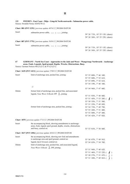
122 SWEDEN - East Coast - Möja - Långvik North-eastwards - Submarine power cable.<br />
Source: Swedish Notice 428/8278/12<br />
Chart 881 (INT 1235) [ previous update 4074/12 ] WGS84 DATUM<br />
Insert<br />
submarine power cable, ÉÊÉ<br />
, joining:<br />
59° 26´·71N., 18° 55´·15E. (shore)<br />
59° 26´·56N., 18° 55´·25E. (shore)<br />
Chart 887 (INT 1775) [ previous update 5639/12 ] WGS84 DATUM<br />
Insert<br />
submarine power cable, ÉÊÉ<br />
, joining:<br />
59° 26´·71N., 18° 55´·15E. (shore)<br />
59° 26´·56N., 18° 55´·25E. (shore)<br />
67 GERMANY - North Sea Coast - Approaches <strong>to</strong> the Jade and Weser - Wangerooge Northwards - Anchorage<br />
areas. Fouls. Legends. Spoil ground. Depths. Wrecks. Obstructions. Buoy.<br />
Source: German <strong>Notices</strong> 46/(21)2/12 & 47/(21)2/12<br />
Chart 1635 (INT 1413) [ previous update 5709/12 ] WGS84 DATUM<br />
Insert limit of anchorage area, pecked line, joining: 53° 55´·00N., 7° 46´·10E.<br />
53° 55´·80N., 7° 52´·61E.<br />
53° 53´·09N., 7° 52´·61E.<br />
53° 54´·19N., 7° 46´·10E.<br />
Delete<br />
«<br />
53° 54´·96N., 7° 47´·60E.<br />
former limit of anchorage area, pecked line, and associated<br />
legend, Neue Weser S-Reede DW ½<br />
, joining:<br />
former limit of anchorage area, pecked line, joining:<br />
53° 51´·93N., 7° 48´·60E.<br />
53° 51´·45N., 7° 53´·20E. ( I]b )<br />
53° 50´·55N., 7° 51´·50E.<br />
53° 51´·25N., 7° 49´·05E.<br />
53° 54´·73N., 7° 49´·79E.<br />
53° 53´·26N., 7° 51´·40E.<br />
53° 53´·80N., 7° 47´·48E.<br />
53° 54´·42N., 7° 47´·02E.<br />
Chart 1875 [ previous update 5711/12 ] WGS84 DATUM<br />
Insert<br />
the accompanying block, showing amendments <strong>to</strong> anchorage<br />
areas, fouls, legend, spoil ground, depths, wrecks, obstructions<br />
and buoy, centred on:<br />
53° 53´·01N., 7° 50´·60E.<br />
Chart 3617 (INT 1456) [ previous update 4816/12 ] WGS84 DATUM<br />
Insert<br />
Delete<br />
the accompanying block, showing new foul and amendments<br />
<strong>to</strong> anchorage area and spoil ground, centred on:<br />
legend, Spoil Ground, centred on:<br />
limit of anchorage area, pecked line, and associated legend,<br />
Neue Weser S-Reede ½ DW, joining:<br />
53° 56´·07N., 7° 49´·91E.<br />
53° 54´·83N., 7° 54´·70E.<br />
53° 51´·94N., 7° 48´·62E.<br />
53° 51´·46N., 7° 53´·22E. ( Ib] )<br />
53° 50´·57N., 7° 51´·47E. ( Gd<br />
)<br />
53° 51´·28N., 7° 49´·01E. ( Jd )<br />
Wk01/13<br />
2.8


