Admiralty Notices to Mariners - United Kingdom Hydrographic Office
Admiralty Notices to Mariners - United Kingdom Hydrographic Office
Admiralty Notices to Mariners - United Kingdom Hydrographic Office

You also want an ePaper? Increase the reach of your titles
YUMPU automatically turns print PDFs into web optimized ePapers that Google loves.
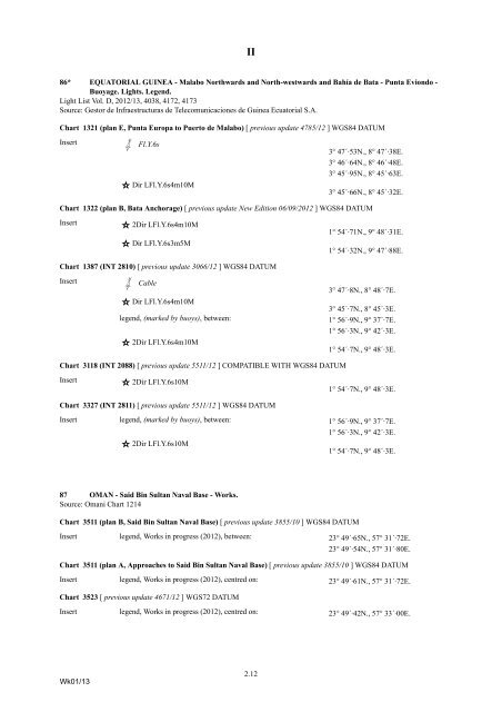
II<br />
86* EQUATORIAL GUINEA - Malabo Northwards and North-westwards and Bahía de Bata - Punta Eviondo -<br />
Buoyage. Lights. Legend.<br />
Light List Vol. D, 2012/13, 4038, 4172, 4173<br />
Source: Ges<strong>to</strong>r de Infraestructuras de Telecomunicaciones de Guinea Ecua<strong>to</strong>rial S.A.<br />
Chart 1321 (plan E, Punta Europa <strong>to</strong> Puer<strong>to</strong> de Malabo) [ previous update 4785/12 ] WGS84 DATUM<br />
Insert<br />
Gf; Fl.Y.6s<br />
3° 47´·53N., 8° 47´·38E.<br />
3° 46´·64N., 8° 46´·48E.<br />
3° 45´·95N., 8° 45´·63E.<br />
Dir LFl.Y.6s4m10M 3° 45´·66N., 8° 45´·32E.<br />
Chart 1322 (plan B, Bata Anchorage) [ previous update New Edition 06/09/2012 ] WGS84 DATUM<br />
Insert<br />
2Dir LFl.Y.6s4m10M 1° 54´·71N., 9° 48´·31E.<br />
Dir LFl.Y.6s3m5M 1° 54´·32N., 9° 47´·88E.<br />
Chart 1387 (INT 2810) [ previous update 3066/12 ] WGS84 DATUM<br />
Insert<br />
Gf; Cable<br />
3° 47´·8N., 8° 48´·7E.<br />
Dir LFl.Y.6s4m10M 3° 45´·7N., 8° 45´·3E.<br />
legend, (marked by buoys), between:<br />
1° 56´·9N., 9° 37´·7E.<br />
1° 56´·3N., 9° 42´·3E.<br />
2Dir LFl.Y.6s4m10M 1° 54´·7N., 9° 48´·3E.<br />
Chart 3118 (INT 2088) [ previous update 5511/12 ] COMPATIBLE WITH WGS84 DATUM<br />
Insert<br />
2Dir LFl.Y.6s10M 1° 54´·7N., 9° 48´·3E.<br />
Chart 3327 (INT 2811) [ previous update 5511/12 ] WGS84 DATUM<br />
Insert legend, (marked by buoys), between: 1° 56´·9N., 9° 37´·7E.<br />
1° 56´·3N., 9° 42´·3E.<br />
2Dir LFl.Y.6s10M 1° 54´·7N., 9° 48´·3E.<br />
87 OMAN - Said Bin Sultan Naval Base - Works.<br />
Source: Omani Chart 1214<br />
Chart 3511 (plan B, Said Bin Sultan Naval Base) [ previous update 3855/10 ] WGS84 DATUM<br />
Insert legend, Works in progress (2012), between: 23° 49´·65N., 57° 31´·72E.<br />
23° 49´·54N., 57° 31´·80E.<br />
Chart 3511 (plan A, Approaches <strong>to</strong> Said Bin Sultan Naval Base) [ previous update 3855/10 ] WGS84 DATUM<br />
Insert legend, Works in progress (2012), centred on: 23° 49´·61N., 57° 31´·72E.<br />
Chart 3523 [ previous update 4671/12 ] WGS72 DATUM<br />
Insert legend, Works in progress (2012), centred on: 23° 49´·42N., 57° 33´·00E.<br />
Wk01/13<br />
2.12