Baseline Study Report on CQ of WAB final - International ...
Baseline Study Report on CQ of WAB final - International ...
Baseline Study Report on CQ of WAB final - International ...

You also want an ePaper? Increase the reach of your titles
YUMPU automatically turns print PDFs into web optimized ePapers that Google loves.
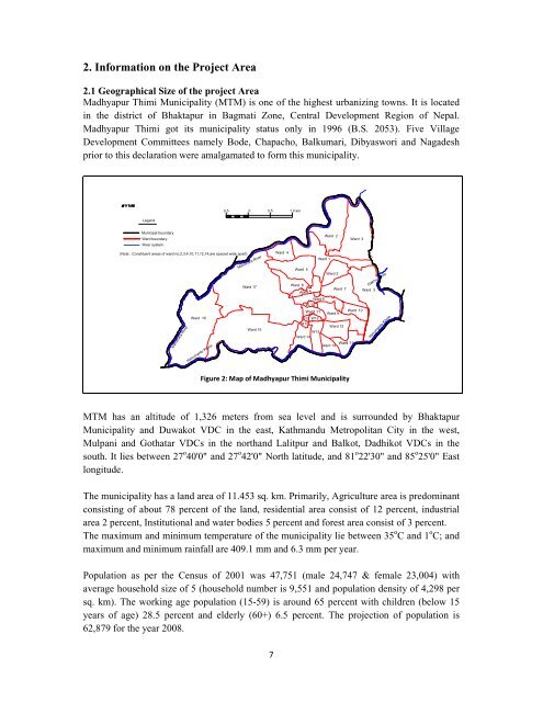
2. Informati<strong>on</strong> <strong>on</strong> the Project Area<br />
2.1 Geographical Size <strong>of</strong> the project Area<br />
Madhyapur Thimi Municipality (MTM) is <strong>on</strong>e <strong>of</strong> the highest urbanizing towns. It is located<br />
in the district <strong>of</strong> Bhaktapur in Bagmati Z<strong>on</strong>e, Central Development Regi<strong>on</strong> <strong>of</strong> Nepal.<br />
Madhyapur Thimi got its municipality status <strong>on</strong>ly in 1996 (B.S. 2053). Five Village<br />
Development Committees namely Bode, Chapacho, Balkumari, Dibyaswori and Nagadesh<br />
prior to this declarati<strong>on</strong> were amalgamated to form this municipality.<br />
<br />
0.5 0 0.5 1.0 km<br />
Legend<br />
Municipal boundary<br />
Ward boundary<br />
River system<br />
Ward 2<br />
Ward 3<br />
(Note : C<strong>on</strong>stituent areas <strong>of</strong> ward no.2,3,4,10,11,12,14,are spaced wide apart)<br />
Manohara River<br />
Hanumante Khola<br />
Manohara River<br />
Ward 17<br />
Ward 16<br />
Ward 15<br />
Ward 4<br />
Ward 5<br />
Ward 6<br />
Ward 4<br />
Ward 8<br />
W 10<br />
Ward 11<br />
W13 W12<br />
W12<br />
W13<br />
Ward 14<br />
Ward 1<br />
Ward 2<br />
Ward 9<br />
Ward 7<br />
Ward 12<br />
Ward 10<br />
Ward 11<br />
Ward 14<br />
Ward 3<br />
Gakhu Khola<br />
Hanumante Khola<br />
Figure 2: Map <strong>of</strong> Madhyapur Thimi Municipality<br />
MTM has an altitude <strong>of</strong> 1,326 meters from sea level and is surrounded by Bhaktapur<br />
Municipality and Duwakot VDC in the east, Kathmandu Metropolitan City in the west,<br />
Mulpani and Gothatar VDCs in the northand Lalitpur and Balkot, Dadhikot VDCs in the<br />
south. It lies between 27 o 40'0" and 27 o 42'0" North latitude, and 81 o 22'30" and 85 o 25'0" East<br />
l<strong>on</strong>gitude.<br />
The municipality has a land area <strong>of</strong> 11.453 sq. km. Primarily, Agriculture area is predominant<br />
c<strong>on</strong>sisting <strong>of</strong> about 78 percent <strong>of</strong> the land, residential area c<strong>on</strong>sist <strong>of</strong> 12 percent, industrial<br />
area 2 percent, Instituti<strong>on</strong>al and water bodies 5 percent and forest area c<strong>on</strong>sist <strong>of</strong> 3 percent.<br />
The maximum and minimum temperature <strong>of</strong> the municipality lie between 35 o C and 1 o C; and<br />
maximum and minimum rainfall are 409.1 mm and 6.3 mm per year.<br />
Populati<strong>on</strong> as per the Census <strong>of</strong> 2001 was 47,751 (male 24,747 & female 23,004) with<br />
average household size <strong>of</strong> 5 (household number is 9,551 and populati<strong>on</strong> density <strong>of</strong> 4,298 per<br />
sq. km). The working age populati<strong>on</strong> (15-59) is around 65 percent with children (below 15<br />
years <strong>of</strong> age) 28.5 percent and elderly (60+) 6.5 percent. The projecti<strong>on</strong> <strong>of</strong> populati<strong>on</strong> is<br />
62,879 for the year 2008.<br />
7