

A REANALYSIS OF HURRICANE ANDREW'S INTENSITY - National ...
A REANALYSIS OF HURRICANE ANDREW'S INTENSITY - National ...
A REANALYSIS OF HURRICANE ANDREW'S INTENSITY - National ...

You also want an ePaper? Increase the reach of your titles
YUMPU automatically turns print PDFs into web optimized ePapers that Google loves.
TABLE 1. Continued.<br />
Date/Time<br />
UTC<br />
Latitude<br />
°N<br />
Longitude<br />
°W<br />
Central<br />
pressure (mb)<br />
Maximum<br />
wind speed (kt)<br />
Storm<br />
status<br />
23/1800<br />
24/0905<br />
23/2100<br />
24/0100<br />
24/0840<br />
24/0905<br />
25.4<br />
25.5<br />
25.4<br />
25.4<br />
25.5<br />
25.5<br />
75.8<br />
80.3<br />
76.6<br />
77.8<br />
80.2<br />
80.3<br />
922<br />
922<br />
923<br />
931<br />
926<br />
922<br />
150 (135)<br />
145 (125)<br />
140 (130)<br />
130 (125)<br />
145<br />
145 (125)<br />
Minimum pressure<br />
“<br />
Eleuthera landfall<br />
Berry Island landfall<br />
Elliott Key, FL, landfall<br />
Fender Point, FL, landfall<br />
[8 nmi (13km) eastnortheast<br />
of Homestead, FL]<br />
Pt. Chevreuil, LA<br />
26/0830<br />
29.6<br />
91.5<br />
956<br />
100 (105)<br />
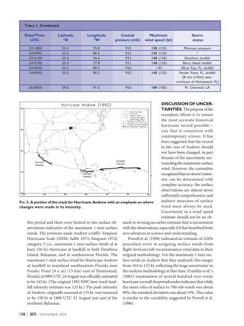
FIG. 5. A portion of the track for Hurricane Andrew with an emphasis on where<br />
changes were made in its intensity.<br />
this period and there were limited in situ surface observations<br />
indicative of the maximum 1-min surface<br />
winds. The revisions made Andrew a Saffir–Simpson<br />
Hurricane Scale (SSHS; Saffir 1973; Simpson 1974)<br />
category-5 (i.e., maximum 1-min surface winds of at<br />
least 136 kt) hurricane at landfall in both Eleuthera<br />
Island, Bahamas, and in southeastern Florida. The<br />
maximum 1-min surface wind for Hurricane Andrew<br />
at landfall in mainland southeastern Florida near<br />
Fender Point [8 n mi (13 km) east of Homestead,<br />
Florida] at 0905 UTC 24 August was officially estimated<br />
to be 145 kt. (The original 1992 NHC best-track landfall<br />
intensity estimate was 125 kt.) The peak intensity<br />
of Andrew, originally assessed at 135 kt, was reasoned<br />
to be 150 kt at 1800 UTC 23 August just east of the<br />
northern Bahamas.<br />
1708 | NOVEMBER 2004<br />
DISCUSSION <strong>OF</strong> UNCER-<br />
TAINTIES. The purpose of the<br />
reanalysis efforts is to ensure<br />
the most accurate historical<br />
hurricane record possible—<br />
one that is consistent with<br />
contemporary science. It has<br />
been suggested that the record<br />
in the case of Andrew should<br />
not have been changed, in part<br />
because of the uncertainty surrounding<br />
the maximum surface<br />
wind. However, the committee<br />
recognized that no storm’s intensity<br />
can be determined with<br />
complete accuracy; the surface<br />
observations are almost never<br />
sufficiently comprehensive, and<br />
indirect measures of surface<br />
wind must always be used.<br />
Uncertainty in a wind speed<br />
estimate should not be an obstacle<br />
to revising an earlier estimate that is inconsistent<br />
with the observations, especially if it has benefited from<br />
new advances in science and understanding.<br />
Powell et al. (1996) indicated an estimate of ±20%<br />
procedure error in assigning surface winds from<br />
flight-level aircraft reconnaissance wind data in their<br />
original methodology. For the maximum 1-min surface<br />
winds in Andrew that they analyzed, this ranges<br />
from 103 to 153 kt, reflecting the large uncertainty in<br />
the analysis methodology at that time. Franklin et al.’s<br />
(2003) examination of several hundred over-ocean<br />
hurricane eyewall dropwindsondes indicates that while<br />
the mean ratio of surface to 700-mb winds was about<br />
90%, the standard deviation was about 19%. This value<br />
is similar to the variability suggested by Powell et al.<br />
(1996).


