

Draft Proposals Paper - Full - Victorian Environmental Assessment ...
Draft Proposals Paper - Full - Victorian Environmental Assessment ...
Draft Proposals Paper - Full - Victorian Environmental Assessment ...

Create successful ePaper yourself
Turn your PDF publications into a flip-book with our unique Google optimized e-Paper software.
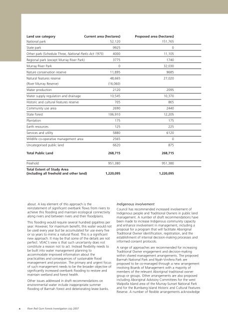
Land use category Current area (hectares) Proposed area (hectares)<br />
National park 52,120 151,765<br />
State park 9925 0<br />
Other park (Schedule Three, National Parks Act 1975) 4000 11,105<br />
Regional park (except Murray River Park) 3775 1740<br />
Murray River Park 0 32,030<br />
Nature conservation reserve 11,895 9685<br />
Natural features reserve 48,665 27,020<br />
(River Murray Reserve) (16,060)<br />
Water production 2120 2095<br />
Water supply regulation and drainage 10,545 10,370<br />
Historic and cultural features reserve 705 865<br />
Community use area 2690 2440<br />
State forest 106,910 12,205<br />
Plantation 175 175<br />
Earth resources 125 225<br />
Services and utility 5880 6120<br />
Wildlife co-operative management area 2565 0<br />
Uncategorised public land 6620 875<br />
Total Public Land 268,715 268,715<br />
Freehold 951,380 951,380<br />
Total Extent of Study Area<br />
(including all freehold and other land) 1,220,095 1,220,095<br />
about. A key element of this approach is the<br />
reinstatement of significant overbank flows from rivers to<br />
achieve this flooding and maintain ecological connectivity<br />
along rivers and between rivers and their floodplains.<br />
This flooding would require several hundred gigalitres per<br />
year. However, for maximum benefit, this water would not<br />
be used every year but be accumulated for use every five<br />
or so years to mimic a natural flood. This is a significant<br />
new approach. It may be that some of the details are not<br />
perfect. VEAC’s view is that such uncertainty does not<br />
constitute a reason not to act. Instead flexibility needs to<br />
be built into water management planning to<br />
accommodate improved information about the<br />
practicalities and consequences of sustainable flood<br />
management and provision. The primary and urgent focus<br />
of such management needs to be the broader objective of<br />
significantly increased overbank flooding to restore and<br />
maintain wetland and forest health.<br />
Other issues addressed in draft recommendations on<br />
environmental water include inappropriate summer<br />
flooding of Barmah forest and deteriorating levee banks.<br />
Indigenous involvement<br />
Council has recommended increased involvement of<br />
Indigenous people and Traditional Owners in public land<br />
management. A number of draft recommendations have<br />
been made to increase Indigenous community capacity<br />
and enhance involvement in management, including a<br />
proposal for a program that will facilitate Aboriginal<br />
Traditional Owner identification, registration, and the<br />
establishment of internal decision-making processes and<br />
informed consent protocols.<br />
A range of approaches are recommended for increasing<br />
Traditional Owner engagement and decision-making<br />
within shared management arrangements. The proposed<br />
Barmah National Park and Nyah-Vinifera Park are<br />
proposed to be co-managed through a new arrangement<br />
involving Boards of Management with a majority of<br />
members of the relevant Aboriginal traditional owner<br />
group or groups. Other arrangements are also proposed<br />
including Aboriginal Advisory Committees for the west<br />
Walpolla Island area of the Murray-Sunset National Park<br />
and for the Bumbang Island Historic and Cultural Features<br />
Reserve. A number of flexible arrangements acknowledge<br />
x River Red Gum Forests Investigation July 2007


