Download a PDF of our 2009 Annual Report - Ancient Egypt ...
Download a PDF of our 2009 Annual Report - Ancient Egypt ...
Download a PDF of our 2009 Annual Report - Ancient Egypt ...

Create successful ePaper yourself
Turn your PDF publications into a flip-book with our unique Google optimized e-Paper software.
Sphinx<br />
Sphinx<br />
Temple<br />
Khafre Valley<br />
Temple<br />
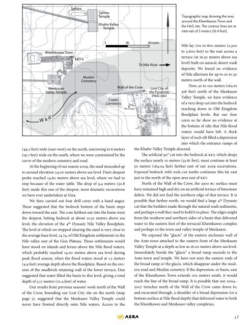
Topographic map showing the area<br />
around the Khentkawes Town and<br />
the HeG site. The cont<strong>our</strong> lines are at<br />
intervals <strong>of</strong> 5 meters (16.4 feet).<br />
W<br />
a<br />
Khentkawes Town<br />
Menkaure<br />
Valley Temple<br />
d i<br />
KKT-E<br />
Muslim<br />
Cemetery<br />
Coptic<br />
Cemetery<br />
(49.2 feet) wide (east-west) on the north, narrowing to 6 meters<br />
(19.7 feet) wide on the south, where we were constrained by the<br />
curve <strong>of</strong> the modern cemetery and road.<br />
At the beginning <strong>of</strong> <strong>our</strong> season <strong>2009</strong>, the sand mounded up<br />
to around elevation 24.00 meters above sea level. Dan’s deepest<br />
probe reached 14.60 meters above sea level, where we had to<br />
stop because <strong>of</strong> the water table. The drop <strong>of</strong> 9.4 meters (30.8<br />
feet) made this one <strong>of</strong> the deepest, most dramatic excavations<br />
we have ever undertaken at Giza.<br />
We then carried out f<strong>our</strong> drill cores with a hand augur.<br />
These suggested that the bedrock bottom <strong>of</strong> the basin steps<br />
down toward the east. The core farthest out into the basin went<br />
the deepest, hitting bedrock at about 12.50 meters above sea<br />
level, the elevation <strong>of</strong> the 4th Dynasty Nile Valley floodplain.<br />
The level at which we stopped clearing the sand is very close to<br />
the average base level, 14.74, <strong>of</strong> Old Kingdom settlements in the<br />
Nile valley east <strong>of</strong> the Giza Plateau. Those settlements would<br />
have stood on islands and levees above the Nile flood waters,<br />
which probably reached 14.00 meters above sea level during<br />
peak flood season, when the flood waters stood at 1.5 meters<br />
(4.9 feet) average depth above the floodplain. Based on the erosion<br />
<strong>of</strong> the mudbrick retaining wall <strong>of</strong> the lower terrace, Dan<br />
suggested that water filled the basin to this level, giving a total<br />
depth <strong>of</strong> 3.17 meters (10.4 feet) <strong>of</strong> water.<br />
Our results from previous seasons’ work north <strong>of</strong> the Wall<br />
<strong>of</strong> the Crow, bounding <strong>our</strong> Lost City site on the north (map<br />
page 5), suggested that the Menkaure Valley Temple could<br />
never have fronted directly onto Nile waters. Access to the<br />
0 100 200 meters<br />
Wall <strong>of</strong> the Crow<br />
The Chute<br />
To Nile River<br />
Lost City <strong>of</strong><br />
the Pyramids<br />
(HeG site)<br />
Nile lay 700 to 800 meters (2,300<br />
to 2,600 feet) to the east across a<br />
terrace (at 16.30 meters above sea<br />
level) built on natural, desert wadi<br />
deposits. We found no evidence<br />
<strong>of</strong> Nile alluvium for up to 20 to 30<br />
meters north <strong>of</strong> the wall.<br />
Now, 50 to 100 meters (164 to<br />
328 feet) north <strong>of</strong> the Menkaure<br />
Valley Temple, we have evidence<br />
<strong>of</strong> a very deep cut into the bedrock<br />
reaching down to Old Kingdom<br />
floodplain levels. But <strong>our</strong> f<strong>our</strong><br />
cores so far show no evidence at<br />
the bottom <strong>of</strong> silts that Nile flood<br />
waters would have left. A thick<br />
layer <strong>of</strong> such silt filled a depression<br />
into which the entrance ramps <strong>of</strong><br />
the Khafre Valley Temple descend.<br />
The artificial 90° cut into the bedrock at KKT, which drops<br />
the surface nearly 10 meters (32.81 feet), must continue at least<br />
50 meters (164.04 feet) farther east <strong>of</strong> <strong>our</strong> <strong>2009</strong> excavations.<br />
Exposed bedrock with rock-cut tombs continues this far east<br />
just to the north <strong>of</strong> the open area east <strong>of</strong> KKT.<br />
North <strong>of</strong> the Wall <strong>of</strong> the Crow, the 2500 BC surface must<br />
have remained high and dry on an artificial terrace <strong>of</strong> limestone<br />
debris. We did not find the northern edge <strong>of</strong> that terrace. It is<br />
possible that farther north, we would find a large 4th Dynasty<br />
cut that the builders made through the natural wadi sediments,<br />
and perhaps a wall they used to hold it in place. The edges might<br />
form the southern and northern sides <strong>of</strong> a basin that delivered<br />
water to the eastern foot <strong>of</strong> the terraced Khentkawes complex<br />
and perhaps to the town and valley temple <strong>of</strong> Menkaure.<br />
We exposed the “glacis” <strong>of</strong> the eastern enclosure wall <strong>of</strong><br />
the Ante-town attached to the eastern front <strong>of</strong> the Menkaure<br />
Valley Temple at a depth as low as 16.00 meters above sea level.<br />
Immediately beside the “glacis” a broad ramp ascends to the<br />
Ante-town and temple. We have not seen the eastern ends <strong>of</strong><br />
the broad ramp or the glacis, which disappear under the modern<br />
road and Muslim cemetery. If the depression, or basin, east<br />
<strong>of</strong> the Khentkawes Town extends 100 meters south, it would<br />
reach the line <strong>of</strong> the broad ramp. It is possible that <strong>our</strong> 2004–<br />
2007 trenches north <strong>of</strong> the Wall <strong>of</strong> the Crow came down to,<br />
and excavated through, a shoulder <strong>of</strong> a broad depression (or a<br />
bottom surface at Nile flood depth) that delivered water to both<br />
the Khentkawes and Menkaure valley complexes.<br />
17