2012 Seafloor Geodesy in Cascadia - William Wilcock - University of ...
2012 Seafloor Geodesy in Cascadia - William Wilcock - University of ...
2012 Seafloor Geodesy in Cascadia - William Wilcock - University of ...

Create successful ePaper yourself
Turn your PDF publications into a flip-book with our unique Google optimized e-Paper software.
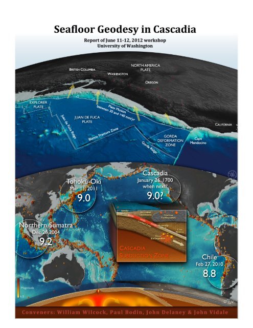
Front Cover. (Upper) Perspective view <strong>of</strong> the Juan de Fuca plate show<strong>in</strong>g plate <br />
boundaries and the convergence between the Juan de Fuca and North American plates <br />
across the <strong>Cascadia</strong> subduction zone. (Lower) Map <strong>of</strong> the Pacific Ocean show<strong>in</strong>g <br />
epicenters <strong>of</strong> teleseismic earthquakes with the sites <strong>of</strong> the 2004 Northern Sumatra, 2010 <br />
Chile and 2011 Tohoku-‐Oki megathrust earthquakes and the <strong>Cascadia</strong> subduction zone <br />
labeled. (Inset) Schematic cross section <strong>of</strong> the <strong>Cascadia</strong> subduction zone illustrat<strong>in</strong>g the <br />
location <strong>of</strong> the locked zone responsible for megathrust earthquakes and distribution <strong>of</strong> <br />
deep and shallow earthquakes. (Base) Schematic cross-‐section <strong>of</strong> a portion <strong>of</strong> the Earth <br />
illustrat<strong>in</strong>g mantle flow and melt<strong>in</strong>g associated with an oceanic spread<strong>in</strong>g center and a <br />
subduction zone (figure created by the Center for Environmental Visualization, <strong>University</strong> <br />
<strong>of</strong> Wash<strong>in</strong>gton). <br />
2
Table <strong>of</strong> Contents <br />
Meet<strong>in</strong>g Summary <br />
Goals <strong>of</strong> the Workshop <br />
<strong>Cascadia</strong> Subduction Zone <br />
Motivation for Offshore <strong>Geodesy</strong> <br />
Exist<strong>in</strong>g Geophysical Infrastructure and Initiatives <strong>in</strong> the Pacific Northwest <br />
<strong>Seafloor</strong> Geodetic Techniques <br />
<strong>Seafloor</strong> Observatories <br />
What Next? <br />
Conclusions and Recommendations <br />
References <br />
Appendix A: List <strong>of</strong> Participants <br />
Appendix B: Meet<strong>in</strong>g Agenda <br />
Appendix C: Selected Abstracts <br />
4 <br />
5 <br />
5 <br />
7 <br />
11 <br />
12 <br />
15 <br />
16 <br />
19 <br />
20 <br />
23 <br />
25 <br />
27 <br />
3
Meet<strong>in</strong>g Summary <br />
Recent devastat<strong>in</strong>g megathrust earthquakes <strong>of</strong>f Sumatra, Chile and Japan have raised <br />
awareness <strong>of</strong> the hazard posed by subduction zones and the <strong>in</strong>evitability <strong>of</strong> a comparable <br />
earthquake along the coast <strong>of</strong> the Pacific Northwest. In contrast to seismic observations, <br />
relatively little attention has been given to the rationale for <strong>of</strong>fshore geodetic observations, <br />
despite their potential importance for understand<strong>in</strong>g the basic science and hazard <strong>of</strong> the <br />
<strong>Cascadia</strong> subduction zone. <strong>Seafloor</strong> geodetic measurements on the <strong>in</strong>com<strong>in</strong>g plate, trench, <br />
and accretionary prism would contribute <strong>in</strong> many ways to understand<strong>in</strong>g the subduction <br />
zone because they have the potential to resolve a variety <strong>of</strong> deformation sources that <br />
cannot be observed by other means. Initial objectives <strong>of</strong> seafloor geodesy should be to <br />
address scientific questions related to measur<strong>in</strong>g and understand<strong>in</strong>g: (1) The motion and <br />
deformation <strong>of</strong> the Juan de Fuca plate, (2) the spatial extent <strong>of</strong> the locked zone <strong>of</strong> the <br />
megathrust and whether some segments <strong>of</strong> the subduction zone are creep<strong>in</strong>g, and (3) the <br />
characteristics <strong>of</strong> <strong>of</strong>fshore transient deformation events. The long-‐term objective should be <br />
real-‐time monitor<strong>in</strong>g along the entire length <strong>of</strong> the subduction zone. This would serve the <br />
dual purposes <strong>of</strong> provid<strong>in</strong>g long-‐term scientific seismic and geodetic observations and <br />
support<strong>in</strong>g earthquake and tsunami warn<strong>in</strong>g systems. Discussions at this workshop have <br />
led to general recommendations for an <strong>in</strong>itial phase <strong>of</strong> observations which are summarized <br />
<strong>in</strong> this report. A community workshop supported by multiple agencies would be the most <br />
productive mechanism to ref<strong>in</strong>e rationale and develop specific plans for a multi-‐component <br />
geodetic observatory network. <br />
4
Goals <strong>of</strong> the Workshop <br />
Recent devastat<strong>in</strong>g megathrust earthquakes <strong>of</strong>f Sumatra, Chile and Japan have further <br />
raised awareness <strong>of</strong> the hazard posed by subduction zones and the <strong>in</strong>evitability <strong>of</strong> a <br />
comparable earthquake along the coast <strong>of</strong> the Pacific Northwest. This meet<strong>in</strong>g arose from <br />
several conversations at the <strong>University</strong> <strong>of</strong> Wash<strong>in</strong>gton that explored the potential synergies <br />
between land-‐based seismic and geodetic monitor<strong>in</strong>g <strong>in</strong> the Pacific Northwest and ongo<strong>in</strong>g <br />
efforts to establish cabled observatories <strong>of</strong>f the coast <strong>of</strong> the Pacific Northwest. Both the <br />
NEPTUNE Canada and Regional Scale Nodes cabled observatories are support<strong>in</strong>g networks <br />
<strong>of</strong> seafloor seismometers. Their <strong>in</strong>stallation is a result <strong>of</strong> extensive discussions and <br />
documentation with<strong>in</strong> the scientific community <strong>of</strong> their scientific worth. In contrast, <br />
relatively little attention has been given to the rationale for <strong>of</strong>fshore geodetic observations, <br />
despite their potential importance for understand<strong>in</strong>g the basic science and hazard <strong>of</strong> the <br />
<strong>Cascadia</strong> subduction zone. <br />
For this reason John Delaney, the Director <strong>of</strong> Regional Scale Nodes Program, and John <br />
Vidale, the Director <strong>of</strong> the Pacific Northwest Seismic Network, provided <strong>in</strong>ternal <strong>University</strong> <br />
<strong>of</strong> Wash<strong>in</strong>gton funds to host a small meet<strong>in</strong>g <strong>of</strong> twenty participants to explore the potential <br />
<strong>of</strong> seafloor geodesy <strong>in</strong> our region. As a result <strong>of</strong> community <strong>in</strong>terest, the size <strong>of</strong> the meet<strong>in</strong>g <br />
grew significantly and on June 11-‐12, <strong>2012</strong>, about fifty scientists and eng<strong>in</strong>eers (Appendix <br />
A), <strong>in</strong>clud<strong>in</strong>g twenty from out <strong>of</strong> town, met for a day and a half on the <strong>University</strong> <strong>of</strong> <br />
Wash<strong>in</strong>gton campus. The meet<strong>in</strong>g agenda (Appendix B) was designed to address three <br />
goals: <br />
1. Develop<strong>in</strong>g the scientific rationale for mak<strong>in</strong>g seafloor geodetic observations <strong>of</strong> <br />
<strong>Cascadia</strong> subduction zone. <br />
2. Discuss<strong>in</strong>g what is best to measure, where to measure it and how. <br />
3. Explor<strong>in</strong>g short-‐term and long-‐term plans for how to build seafloor geodesy upon <br />
current efforts. <br />
This report provides a short summary <strong>of</strong> the meet<strong>in</strong>g. <br />
<strong>Cascadia</strong> Subduction Zone <br />
The <strong>Cascadia</strong> subduction zone extends 1100 km from Cape Mendoc<strong>in</strong>o, California to <br />
northern Vancouver Island and marks the boundary along which the small Juan de Fuca <br />
oceanic plate subducts beneath North America (Figure 1). Convergence occurs <strong>in</strong> a <br />
northeast direction at modest rates rang<strong>in</strong>g from 30 mm/yr <strong>of</strong>f northern California to over <br />
40 mm/yr <strong>of</strong>f Vancouver Island. Because the subduct<strong>in</strong>g Juan de Fuca plate is young (5-‐10 <br />
Ma) and thus warm, the locked zone that fails <strong>in</strong> megathrust earthquakes is relatively <br />
shallow and lies almost exclusively <strong>of</strong>fshore. The Juan de Fuca plate is blanketed by up to <br />
4-‐5 km <strong>of</strong> glacial sediments that bury the trench and reduce seafloor depths. Most <strong>of</strong> the <br />
sediments on the <strong>in</strong>com<strong>in</strong>g plate are scraped <strong>of</strong>f to form an active accretionary prism that <br />
extends shoreward from a sharp deformation front and lies outboard <strong>of</strong> older, accreted <br />
terranes that form the rock framework <strong>of</strong> the marg<strong>in</strong>. An active volcanic arc extends the <br />
full length <strong>of</strong> the subduction zone. <br />
5
Figure 1. Map <strong>of</strong> the Pacific <br />
Northwest show<strong>in</strong>g plate <br />
boundaries, convergence rates <br />
across the <strong>Cascadia</strong> subduction <br />
zone and arc volcanoes <br />
(modified from Haugerud, 2000). <br />
Current seismicity <strong>in</strong> the subduction zone is largely conf<strong>in</strong>ed to < 90 km depth, <strong>in</strong>-‐slab <br />
events <strong>in</strong> the down go<strong>in</strong>g Juan de Fuca plate, largely beneath the Puget Lowland and <br />
around the Mendoc<strong>in</strong>o Triple Junction and eerily is almost non-‐existent on the plate <br />
boundary. However, the geologic record <strong>of</strong> episodic coastal subsidence and <strong>of</strong>fshore <br />
turbidites confirm that this <strong>in</strong>terface has produced numerous great megathrust <br />
earthquakes and tsunamis <strong>in</strong> Holocene time, with an average recurrence <strong>in</strong>terval <strong>of</strong> about <br />
500 years (Goldf<strong>in</strong>ger, 2011). The most recent great earthquake (estimated magnitude 9) <br />
occurred <strong>in</strong> 1700, caus<strong>in</strong>g widespread tsunami damage <strong>in</strong> Japan (Atwater et al., 2005). <br />
Global Position<strong>in</strong>g System (GPS) measurements document northeastward compression <br />
above the megathrust, <strong>in</strong>dicat<strong>in</strong>g that it is presently locked and accumulat<strong>in</strong>g <strong>in</strong>terseismic <br />
stra<strong>in</strong> and is <strong>in</strong> the late (high stress and low stra<strong>in</strong> rate) stage <strong>of</strong> the subduction cycle. <br />
Geological studies suggest that there is a 25-‐40% probability <strong>of</strong> a magnitude 8+ megathrust <br />
earthquake on the subduction zone <strong>in</strong> the next 50 years (Goldf<strong>in</strong>ger et al., <strong>2012</strong>). <br />
South <strong>of</strong> Vancouver Island, convergence is oblique with a dextral shear across the plate <br />
boundary. On land, the GPS velocity field (McCaffrey et al., 2007) documents a regional <br />
clockwise rotation <strong>of</strong> the upper plate at about 1°/Ma, which causes the upper plate to break <br />
up <strong>in</strong>to blocks, and causes marg<strong>in</strong>-‐parallel shorten<strong>in</strong>g and tectonic segmentation <strong>of</strong> the <br />
marg<strong>in</strong> (Figure 2). This segmentation, along with westward <strong>in</strong>creas<strong>in</strong>g dextral shear <br />
toward the plate boundary may cause seismic segmentation and complex strike slip <br />
fault<strong>in</strong>g <strong>of</strong> the shallow megathrust. <br />
6
Figure 2. GPS velocities and 70% confidence ellipses <strong>in</strong> the North American reference <br />
frame for cont<strong>in</strong>uous (red) and campaign (blue) sites (from McCaffrey et al., 2007). <br />
Motivation for Offshore <strong>Geodesy</strong> <br />
<strong>Seafloor</strong> geodetic measurements on the <strong>in</strong>com<strong>in</strong>g plate, trench, and accretionary prism <br />
would contribute <strong>in</strong> many ways to understand<strong>in</strong>g the subduction zone because they have <br />
the potential to resolve a variety <strong>of</strong> deformation sources. In global plate tectonic k<strong>in</strong>ematic <br />
models, the motion <strong>of</strong> the Juan de Fuca plate is only constra<strong>in</strong>ed <strong>in</strong>directly. Direct <br />
measurements <strong>of</strong> the motion <strong>of</strong> the Juan de Fuca plate relative to North America provide a <br />
first-‐order constra<strong>in</strong>t on the convergence and shear across the plate boundary. <br />
Measurements <strong>of</strong> plate motion have been obta<strong>in</strong>ed at three locations on the Juan de Fuca <br />
plate us<strong>in</strong>g GPS-‐acoustic techniques (Chadwell and Spiess, 2008). Interest<strong>in</strong>gly, the <br />
measurement obta<strong>in</strong>ed 150 km <strong>of</strong>fshore central Oregon reveals that the plate motion is <br />
50% slower and rotated 25° more easterly than predicted by the geomagnetic anomalies <br />
that constra<strong>in</strong> current k<strong>in</strong>ematic models. It appears that the oceanic plate may be <br />
deform<strong>in</strong>g <strong>in</strong> this region due to a comb<strong>in</strong>ation <strong>of</strong> regional plate forces act<strong>in</strong>g with<strong>in</strong> the <br />
subduction zone between the obliquely converg<strong>in</strong>g and weaker downgo<strong>in</strong>g slab and the <br />
stronger accreted terra<strong>in</strong>s <strong>of</strong> the forearc. However, globally very little is known about <br />
<strong>in</strong>terseismic deformation <strong>of</strong> <strong>in</strong>com<strong>in</strong>g plates at subduction zones, which makes this lone <br />
observation difficult to <strong>in</strong>terpret. <br />
Over <strong>in</strong>terseismic time scales, convergence between the Juan de Fuca and North <br />
American plates accumulates <strong>in</strong> the locked zone (Burgette et al., 2009), a region that will <br />
7
eventually rupture <strong>in</strong> a megathrust earthquake (Figure 3). The up-‐dip limit <strong>of</strong> the locked <br />
zone is unconstra<strong>in</strong>ed by onshore observations. Offshore measurements <strong>of</strong> long-‐term <br />
vertical and/or horizontal deformation above the shallow slab would constra<strong>in</strong> the updip <br />
extent <strong>of</strong> lock<strong>in</strong>g with important implications for the size and tsunamigenic potential <strong>of</strong> a <br />
megathrust earthquakes. Slow slip and tremor have been identified beneath the outer <br />
accretionary prism <strong>of</strong> the Nankai Subduction zone (Obara and Ito, 2005) seaward <strong>of</strong> the <br />
locked zone. If present <strong>in</strong> <strong>Cascadia</strong>, these transient events would further constra<strong>in</strong> the <br />
extent <strong>of</strong> the locked zone. We know that the <strong>Cascadia</strong> subduction zone is segmented, but <br />
because the complex deformation <strong>of</strong> the forearc masks the megathrust lock<strong>in</strong>g signal, it is <br />
hard to know whether some segments are silently creep<strong>in</strong>g. <strong>Seafloor</strong> geodetic <br />
measurements that spanned the trench at multiple locations along the subduction zone <br />
could address this question. If near trench transient events <strong>in</strong> <strong>Cascadia</strong> were associated <br />
with the deep episodic tremor and slip events that are abundant <strong>in</strong> <strong>Cascadia</strong>, it might <br />
<strong>in</strong>dicate regions <strong>in</strong> which the megathrust is <strong>in</strong>completely locked. <br />
Figure 3. A model <strong>of</strong> the slip deficit fraction φ <br />
(lock<strong>in</strong>g) on the <strong>Cascadia</strong> subduction zone derived <br />
from land GPS measurements (from McCaffrey et al., <br />
2007) <br />
The convergence between the plates is accommodated across the plate marg<strong>in</strong> by <br />
geologic structures <strong>in</strong> the forearc (Goldf<strong>in</strong>ger et al., 1996). Geodetic observations across <br />
the prism would constra<strong>in</strong> the partition<strong>in</strong>g <strong>of</strong> stra<strong>in</strong> across prism and the distribution <strong>of</strong> <br />
active faults. Offshore observations would constra<strong>in</strong> how the northward migration <strong>of</strong> the <br />
forearc is l<strong>in</strong>ked to the northward component <strong>of</strong> along-‐strike motion <strong>of</strong> the Juan de Fuca <br />
plate (Wells et al., 1998). The occurrence <strong>of</strong> very-‐low-‐frequency (VLF) events near the <br />
trench would elucidate the frictional behavior <strong>of</strong> splay and detachment structures, and <br />
provide <strong>in</strong>sight on the potential for tsunamigenic earthquakes along the marg<strong>in</strong> (Sugioka et <br />
al., <strong>2012</strong>). Geodetic observations on the prism would also have the potential to resolve <br />
submar<strong>in</strong>e landslides and slumps. <br />
8
When the megathrust fails, seafloor geodetic observations will constra<strong>in</strong> the co-‐ and <br />
post-‐seismic slip and deformation, which will provide important constra<strong>in</strong>ts on mantle <br />
rheology (Wang et al., <strong>2012</strong>). To the west <strong>of</strong> the trench, flexural stresses are released by <br />
outer rise earthquakes (Clouard et al., 2007). The oceanic plate undergoes <strong>in</strong>ternal <br />
deformation as it is flexed and pulled to the east. Some <strong>of</strong> this deformation is <br />
accommodated by <strong>in</strong>traplate earthquakes along <strong>in</strong>herent weaknesses and fracture zones. <br />
External driv<strong>in</strong>g forces from the trench or ridge transmit across the plate (Fox et al., 1999) <br />
and trigger far-‐field events or drive transient deformation from viscous coupl<strong>in</strong>g with the <br />
underly<strong>in</strong>g mantle. F<strong>in</strong>ally, any <strong>of</strong>fshore geodetic array is likely to discover unanticipated <br />
deformation sources. Some examples might <strong>in</strong>clude premonitory slip on the megathrust <br />
(Kato et al., <strong>2012</strong>), poroelastic deformation <strong>of</strong> the prism from fluid flux (Ranero et al., 2008) <br />
or the dissociation <strong>of</strong> gas hydrates, and bas<strong>in</strong> subsidence <strong>of</strong> the cont<strong>in</strong>ental shelf from the <br />
compaction <strong>of</strong> sediment or subduction erosion. <br />
Figure 4. Coseismic displace-ment<br />
and fault slip <strong>of</strong> the To-hoku-‐Oki<br />
magnitude 9 earth-quake<br />
based on model<strong>in</strong>g on-shore<br />
GPS and seafloor GPS-acoustic<br />
observations (from <br />
Newman, 2011 with seafloor <br />
observations based on Sato et al., <br />
2011) <br />
The importance <strong>of</strong> geodetic observations <strong>in</strong> subduction zones was clearly illustrated by <br />
the 2011 magnitude 9.0 Tohoku-‐Oki earthquake <strong>in</strong> Japan (Figure 4). Here an extensive <br />
network <strong>of</strong> GPS stations on-‐land would, if used <strong>in</strong> real time, have easily constra<strong>in</strong>ed the full <br />
magnitude <strong>of</strong> the event with<strong>in</strong> 1-‐2 m<strong>in</strong>utes. Instead, exist<strong>in</strong>g systems us<strong>in</strong>g only seismic <br />
monitor<strong>in</strong>g required ~20 m<strong>in</strong>utes. The Tohoku earthquake occurred <strong>in</strong> a region where <br />
there were also a significant number <strong>of</strong> seafloor geodetic observations above the rupture <br />
zone. Repeat GPS-‐Acoustic fixes documented the deformation and subsequent restoration <br />
<strong>of</strong> <strong>in</strong>terplate coupl<strong>in</strong>g associated with an magnitude 7.2 thrust earthquake <strong>in</strong> 2005 and <br />
show that the co-‐seismic slip associated with 2011 earthquake exceeded 50 m near the <br />
trench, about twice that <strong>in</strong>ferred from model<strong>in</strong>g data on land. If this data had been <br />
available <strong>in</strong> real time for the 2011 earthquake it would have decreased even further the <br />
time necessary to acquire the data to constra<strong>in</strong> the size <strong>of</strong> the event. Ocean bottom <br />
pressure time series on autonomous <strong>in</strong>struments recorded vertical seafloor movements <br />
9
associated with both the largest foreshock and the ma<strong>in</strong>shock and are consistent with a <br />
model <strong>in</strong> which afterslip for the foreshock propagated toward the ma<strong>in</strong>shock hypocenter. <br />
The seafloor pressure data also revealed a very heterogeneous distribution <strong>of</strong> after-‐slip. <br />
Based on their experiences, Japan is now <strong>in</strong>vest<strong>in</strong>g substantial resources (~$500M) <strong>in</strong> <br />
expand<strong>in</strong>g the number <strong>of</strong> seafloor geodetic observations and <strong>in</strong> <strong>in</strong>stall<strong>in</strong>g an underwater <br />
cable network to obta<strong>in</strong> seafloor seismic and geodetic data <strong>in</strong> real time (Figure 5). <br />
Discussion at the meet<strong>in</strong>g envisioned the potential for a synoptic monitor<strong>in</strong>g system <strong>in</strong> <br />
<strong>Cascadia</strong> <strong>in</strong>tegrat<strong>in</strong>g seafloor and onshore deformation and seismic observations. <br />
Figure 5. (Left) Pre-‐Tohoko earthquake acoustic-‐GPS sites operated by the Japan Coast Guard and <br />
Tohoku <strong>University</strong> and 20 new sites operated by Tohoku and Nagoya Universities (Ishikawa et al., <br />
<strong>2012</strong>). (Right) The Japan Trench Ocean Bottom Seismic and Tsunami Network will be <strong>in</strong>stalled by <br />
2015 and comprises 5700 kilometers <strong>of</strong> cable and 154 nodes (Uehira et al., <strong>2012</strong>). Each node <br />
comprises a Geospace Technologies three component seismometer, two JAE three component <br />
accelerometers, two Paroscientific Nano-‐Resolution depth sensors and a three-‐component Nano-‐<br />
Resolution accelerometer. (Also under consideration for Japan is a land-‐based tsunami warn<strong>in</strong>g <br />
system that will detect tsunamis through the use <strong>of</strong> <strong>in</strong>frasound sensors (Paros et al., <strong>2012</strong>)). <br />
10
Exist<strong>in</strong>g Geophysical Infrastructure and Initiatives <strong>in</strong> the Pacific Northwest <br />
In recent years, the National Science Foundation (NSF) and other agencies have made <br />
considerable and ongo<strong>in</strong>g <strong>in</strong>vestments <strong>in</strong> <strong>in</strong>frastructure for geoscience <strong>in</strong> <strong>Cascadia</strong>. For <br />
example, NSF GeoPRISMS program recently identified <strong>Cascadia</strong> as a Primary Site and <strong>in</strong> <br />
April about 150 scientists attended a plann<strong>in</strong>g workshop <strong>in</strong> Portland. This meet<strong>in</strong>g had a <br />
broad focus and documented extensive <strong>in</strong>terest <strong>in</strong> research related to the <strong>Cascadia</strong> <br />
subduction zone. <br />
On land, the Pacific Northwest Seismic Network (PNSN) operates a seismic network <strong>of</strong> <br />
broadband, short period and strong motion sensors with operational support from the <br />
United States Geological Survey, Department <strong>of</strong> Energy and State <strong>of</strong> Wash<strong>in</strong>gton. The <br />
number <strong>of</strong> broadband stations has been steadily expand<strong>in</strong>g and now numbers ~100. Most <br />
recently 27 temporary sites <strong>in</strong> the Earthscope USArray transportable network were <br />
re<strong>in</strong>stalled as part <strong>of</strong> the <strong>Cascadia</strong> Initiative, 5 <strong>in</strong> California and the rest <strong>in</strong> Oregon and <br />
Wash<strong>in</strong>gton, which might convert to permanent broadband PNSN <strong>in</strong>stallations. This $2.5M <br />
<strong>in</strong>frastructure <strong>in</strong>vestment by NSF was part <strong>of</strong> the <strong>Cascadia</strong> Initiative, supported with funds <br />
from the 2009 Stimulus or ARRA (American Recovery and Re<strong>in</strong>vestment Act). ARRA funds <br />
are also allow<strong>in</strong>g the upgrade <strong>of</strong> 18 more stations to broadband capabilities through the <br />
USGS. Onshore GPS data <strong>in</strong> <strong>Cascadia</strong> is provided by ~470 stations operated (<strong>in</strong> <br />
approximately equal numbers) by both The Pacific Northwest Geodetic Array (PANGA) and <br />
the NSF-‐funded Plate Boundary Observatory (PBO). The <strong>Cascadia</strong> Initiative provided $2.5M <br />
<strong>of</strong> ARRA funds to upgrade the PBO sites, so that the comb<strong>in</strong>ed regional network has <br />
uniformly high-‐sample-‐rate (1-‐Hz) with real-‐time cont<strong>in</strong>uous telemetry. <br />
The <strong>Cascadia</strong> Initiative provided $5M for the construction <strong>of</strong> 60 ocean bottom <br />
seismometers (OBSs), <strong>in</strong>clud<strong>in</strong>g new designs with trawl-‐resistant enclosures to facilitate <br />
shallow-‐water deployment. Over the years from 2011-‐15, the <strong>Cascadia</strong> Initiative OBSs and <br />
ten additional <strong>in</strong>struments will each be deployed four times for one year and will occupy <br />
~160 sites. The deployment pattern comprises a 70-‐km grid that spans the Juan de Fuca <br />
plate, which is designed to extend the US Array transportable grid <strong>of</strong>fshore, a smaller <br />
<strong>in</strong>strument spac<strong>in</strong>g along the subduction zone to detect small earthquakes and dense <br />
deployments on the subduction zone <strong>of</strong>f Grays Harbor, Wash<strong>in</strong>gton; Newport, Oregon; and <br />
Cape Mendoc<strong>in</strong>o, California. <br />
Both Ocean Networks Canada and the NSF Ocean Observatory Initiative (OOI) are <br />
support<strong>in</strong>g the development <strong>of</strong> regional cabled observatories on <strong>Cascadia</strong> marg<strong>in</strong> and Juan <br />
de Fuca plate. The NEPTUNE Canada observatory comprises five <strong>in</strong>strumented nodes on <br />
an 800 km cable loop that crosses the cont<strong>in</strong>ental shelf <strong>in</strong> two locations and extends to the <br />
Juan de Fuca Ridge. The Regional Scale Nodes <strong>of</strong> the OOI is <strong>in</strong> the midst <strong>of</strong> <strong>in</strong>stall<strong>in</strong>g <br />
extensive networks <strong>of</strong> cabled seafloor and water column <strong>in</strong>struments at Axial Seamount on <br />
the Juan de Fuca Ridge and at several sites on the marg<strong>in</strong> <strong>of</strong>f Newport, Oregon <strong>in</strong>clud<strong>in</strong>g <br />
Hydrate Ridge. The two systems will <strong>in</strong>itially <strong>in</strong>clude 8 broadband seismometers (3 are <br />
presently <strong>in</strong>stalled on NEPTUNE Canada) and small local short-‐period seismic networks at <br />
Hydrate Ridge, the Endeavour Segment and Axial Seamount. In addition bottom pressure <br />
observations are be<strong>in</strong>g obta<strong>in</strong>ed at multiple locations and the NEPTUNE Canada <br />
11
observatory is connected to one <strong>in</strong>strumented mid-‐plate borehole and <strong>in</strong> addition is set to <br />
connect to IODP Hole 1364A on the marg<strong>in</strong> <strong>of</strong>f Vancouver Island for which WHOI has <br />
secured funds from the Keck Foundation to <strong>in</strong>stall borehole tiltmeters. Borehole fluid <br />
pressure monitor<strong>in</strong>g systems (CORKs), presently operat<strong>in</strong>g <strong>in</strong> these holes and <strong>in</strong> <br />
autonomous mode <strong>in</strong> several other boreholes on the Juan de Fuca plate, respond to seismic <br />
and aseismic stra<strong>in</strong> transients and serve as sensitive proxy volumetric stra<strong>in</strong> meters. <br />
On a bas<strong>in</strong> scale, NOAA operates an array <strong>of</strong> Deep-‐ocean Assessment and Report<strong>in</strong>g <strong>of</strong> <br />
Tsunami (DART) buoys as part <strong>of</strong> national and <strong>in</strong>ternational efforts to improve capabilities <br />
for the early detection and real-‐time report<strong>in</strong>g <strong>of</strong> tsunamis. Three <strong>of</strong> these buoys are <br />
deployed <strong>of</strong>f <strong>Cascadia</strong>. While the primary function <strong>of</strong> near shore DART buoys is to <br />
constra<strong>in</strong> the size <strong>of</strong> outgo<strong>in</strong>g tsunamis that will propagate across the ocean, there is <br />
clearly merit to predict<strong>in</strong>g the size <strong>of</strong> local tsunamis. One <strong>of</strong> the major challenges is to <br />
forecast tsunamis <strong>in</strong> the near field where the tsunami wave is <strong>of</strong>ten overwhelmed by the <br />
seismic event. A 17-‐month experiment at the Monterey Accelerated Research System <br />
(MARS) cabled observatory demonstrated the ability to make high resolution pressure <br />
measurements <strong>of</strong> micro-‐tsunamis, earthquakes, microseisms and <strong>in</strong>fra-‐gravity waves <br />
(Paros et al., <strong>2012</strong>). <br />
After a decade-‐long hiatus <strong>in</strong> the acquisition <strong>of</strong> deep seismic reflection data on <strong>Cascadia</strong> <br />
marg<strong>in</strong>, there have been several reflection experiments <strong>in</strong> the region this year us<strong>in</strong>g the <br />
R/V Langseth. Seismic reflection imag<strong>in</strong>g <strong>in</strong> subduction zones is an important complement <br />
to seismic and geodetic monitor<strong>in</strong>g. For example seismic images are critical for mapp<strong>in</strong>g <br />
structural features to better assess the extent <strong>of</strong> megathrust lock<strong>in</strong>g and whether the <br />
rupture zone extends seaward to the trench. They are necessary to assess the <strong>in</strong>fluence <strong>of</strong> <br />
geometrical irregularities on the subduct<strong>in</strong>g plate such as seamounts and <strong>of</strong> structure <strong>in</strong> <br />
the overrid<strong>in</strong>g plate <strong>in</strong> creat<strong>in</strong>g megathrust segmentation. <br />
Given all the <strong>in</strong>vestments <strong>in</strong> monitor<strong>in</strong>g <strong>in</strong>frastructure and scientific <strong>in</strong>itiatives, it is <br />
strik<strong>in</strong>g that there is not yet a community effort <strong>in</strong> place to obta<strong>in</strong> seafloor geodetic data <br />
from the <strong>Cascadia</strong> subduction zone. <br />
<strong>Seafloor</strong> Geodetic Techniques <br />
On land, the availability <strong>of</strong> dense networks <strong>of</strong> GPS stations and maps <strong>of</strong> ground <br />
displacement obta<strong>in</strong>ed us<strong>in</strong>g <strong>in</strong>terferometric synthetic aperture radar (InSAR) has <br />
revolutionized our ability to understand tectonic and volcanic processes. Because the <br />
oceans do not transmit the electromagnetic waves that enable these techniques, geodetic <br />
measurements on the seafloor are much more challeng<strong>in</strong>g. There are a variety <strong>of</strong> <br />
complementary approaches to seafloor geodesy with ongo<strong>in</strong>g technique development <br />
efforts focused on improv<strong>in</strong>g the accuracy and reduc<strong>in</strong>g the costs <strong>of</strong> observations. <br />
Offshore GPS or GPS-‐Acoustics comb<strong>in</strong>es k<strong>in</strong>ematic GPS with precision acoustic rang<strong>in</strong>g <br />
to seabed transponders from a sea surface platform to track the horizontal motion <strong>of</strong> the <br />
seafloor (Figure 6). Conventionally the platform is a ship and acoustic rang<strong>in</strong>g is used to <br />
locate the ships horizontal position relative to the center <strong>of</strong> a small network <strong>of</strong> seafloor <br />
12
transponders and GPS is used to locate the ship and thus the position <strong>of</strong> the transponder <br />
network. Repeat campaign style measurements over several years can constra<strong>in</strong> plate <br />
motion (or the slip for any <strong>in</strong>terven<strong>in</strong>g earthquake). Because the ship must sit on station <br />
for several days to obta<strong>in</strong> a horizontal position with an accuracy <strong>of</strong> about a centimeter, the <br />
measurements are expensive and time consum<strong>in</strong>g. One approach to reduc<strong>in</strong>g costs is to <br />
use an alternative sea surface platform. Efforts are underway at SIO to develop systems <br />
that use an autonomous wave glider (an aquatic robot) for repeat campaign measurements <br />
or a moored buoy for cont<strong>in</strong>uous observations. In addition SIO and LDEO are develop<strong>in</strong>g a <br />
seafloor geodetic benchmark that simplifies the replacement <strong>of</strong> seafloor transponders <br />
when the batteries run out. <br />
Figure 6. GPS-‐acoustic methods can <br />
extend GPS observation <strong>of</strong>fshore <br />
(from Newman, 2011). <br />
An alternative approach to conventional <strong>of</strong>fshore GPS is the Geodetic Acoustic <br />
Benchmark Beacon Inverted EchoSounder (GABBIES) be<strong>in</strong>g developed at URI. In this <br />
method a s<strong>in</strong>gle acoustic beacon is located on the seafloor both horizontally and vertically <br />
by rang<strong>in</strong>g from two accurately navigated ship tracks that cross over the beacon. This <br />
method could also be adapted to cheaper autonomous unmanned surface vehicles. <br />
Vertical deformation <strong>of</strong> the seafloor is measured us<strong>in</strong>g absolute pressure gauges that <br />
are based on quartz stra<strong>in</strong> gauge technology. The Paroscientific Nano-‐Resolution Depth <br />
Sensors are capable <strong>of</strong> measur<strong>in</strong>g seafloor pressures with a resolution <strong>of</strong> 0.0001% and <br />
long-‐term drift rates as low as a few centimeters per year. These drift rates exceed the <br />
long-‐term signal (mm/yr) expected from stra<strong>in</strong> accumulation above the locked zone but <br />
would not obscure signals associated with many transient events. At Axial Seamount long <br />
term monitor<strong>in</strong>g <strong>of</strong> volcanic <strong>in</strong>flation with absolute pressure gauges has been comb<strong>in</strong>ed <br />
with campaign-‐style measurements us<strong>in</strong>g a mobile pressure recorder deployed from a <br />
remotely operated vehicle onto seafloor benchmarks to correct for differential drift <br />
between stations and obta<strong>in</strong> relative depth measurements with a repeatability <strong>of</strong> ~1 cm/yr <br />
(Chadwick et al., <strong>2012</strong>). The results document long-‐term uplift at ~15 cm/yr due to <br />
<strong>in</strong>flation <strong>of</strong> and deflation dur<strong>in</strong>g eruptions <strong>of</strong> up to 2-‐3 m over a week. A similar approach <br />
has been used on the East Pacific Rise and is planned for <strong>Cascadia</strong> subduction zone around <br />
13
ODP/IODP Sites 889 and 1364 <strong>of</strong>f Vancouver Island. An alterative approach to m<strong>in</strong>imize <br />
the effects <strong>of</strong> pressure sensor drift is to <strong>in</strong>clude a means to calibrate observation <strong>in</strong> situ. In <br />
a system under development at SIO, a pair <strong>of</strong> quartz pressure gauges that record ambient <br />
seawater pressure are periodically connected to a piston gauge calibrator. <strong>Seafloor</strong> <br />
pressure measurements can be comb<strong>in</strong>ed with absolute gravity to <strong>in</strong>fer subsurface density <br />
changes; to date this approach has been primarily focused at monitor<strong>in</strong>g production from <br />
oil and natural gas reservoirs but it could also be applied to tectonically-‐<strong>in</strong>duced changes <strong>in</strong> <br />
subsurface density. <br />
Tilt meters usually measure the rotation along two horizontal axes to obta<strong>in</strong> a local <br />
measurement <strong>of</strong> the gradient <strong>in</strong> vertical deformation. Conventional short-‐basel<strong>in</strong>e modern <br />
<strong>in</strong>struments use a pair <strong>of</strong> spirit levels with electrode sensors and are widely used to <br />
monitor volcanic <strong>in</strong>flation on land. Unfortunately their drift rate can reach 1 μrads/day, <br />
which exceeds the long-‐term signal <strong>of</strong> ~ 0.1-‐1 μrads/yr expected above the locked <br />
zone. Several such tiltmeters manufactured by LGM Lippman are planned for <strong>in</strong>stallation <br />
<strong>in</strong> IODP hole 1364 on the accretionary prism <strong>of</strong>f Vancouver Island, and will be useful for <br />
identify<strong>in</strong>g earthquake and slow-‐slip events. MEMS accelerometer-‐based tiltmeters have <br />
recently been developed by a number <strong>of</strong> companies for use <strong>in</strong> <strong>in</strong>dustry applications and are <br />
attractive for geodetic applications because they should not suffer from <strong>in</strong>strument <br />
drift. Another promis<strong>in</strong>g approach for measur<strong>in</strong>g tilt and seismic displacements is the use <br />
<strong>of</strong> <strong>in</strong>terferometry to measure the motion <strong>of</strong> an <strong>in</strong>ertial mass. <br />
L<strong>in</strong>ear stra<strong>in</strong>meters measure the change <strong>in</strong> distance between two po<strong>in</strong>ts on the seafloor. <br />
Conventionally such measurements have been obta<strong>in</strong>ed by rang<strong>in</strong>g between acoustic <br />
beacons with the precision <strong>of</strong> measurements limited by our knowledge <strong>of</strong> changes <strong>in</strong> the <br />
speed <strong>of</strong> sound. An alternative sensor and deployment system called the Fiber Optic <br />
<strong>Seafloor</strong> Stra<strong>in</strong>meter has been developed at SIO. The system is presently capable <strong>of</strong> <br />
measur<strong>in</strong>g changes <strong>in</strong> the length <strong>of</strong> a 1-‐km-‐long buried optical fiber with a precision <strong>of</strong> 1 <br />
mm and may eventually have a sensitivity <strong>of</strong> about 1 nanostra<strong>in</strong>. <br />
Measurements <strong>of</strong> fluid pressures changes <strong>in</strong> hydraulically isolated boreholes can be <br />
used to <strong>in</strong>fer volumetric stra<strong>in</strong> perturbations. Such observations <strong>in</strong> boreholes on the Juan <br />
de Fuca plate have been used to <strong>in</strong>fer the deformation associated with ridge spread<strong>in</strong>g and <br />
transform earthquakes. Observations from Costa Rica and the Nankai show that boreholes <br />
on the <strong>in</strong>com<strong>in</strong>g plate and toe <strong>of</strong> the accretionary prism are capable <strong>of</strong> monitor<strong>in</strong>g <br />
<strong>in</strong>terseismic stra<strong>in</strong> accumulation and a range <strong>of</strong> episodic deformational events (Davis et al., <br />
2011). <br />
In the absence <strong>of</strong> seafloor geodetic data or boreholes, fluid flow through the uppermost <br />
sediment column <strong>in</strong> subduction zone forearcs can also be used as a low-‐cost proxy for <br />
stra<strong>in</strong>. Due to the high hydraulic impedance <strong>of</strong> typical prism sediments, rapid changes <strong>in</strong> <br />
flow rate may <strong>in</strong>dicate deformation <strong>of</strong> the upper few meters <strong>of</strong> sediment below an <br />
<strong>in</strong>strument. Results from Costa Rica show that flow-‐meter-‐based tracer <strong>in</strong>jection and <br />
sampl<strong>in</strong>g driven by osmotic pumps is sensitive to the stra<strong>in</strong>s associated with slow slip <br />
events. With some assumptions, flow rate transients can be used to estimate rupture <br />
location, extent, propagation velocity, and duration. <br />
14
<strong>Seafloor</strong> Observatories <br />
Traditionally, geophysical times series are obta<strong>in</strong>ed on the seafloor us<strong>in</strong>g autonomous <br />
packages that record data <strong>in</strong>ternally for analysis only after the <strong>in</strong>struments are recovered. <br />
If real-‐time or near real-‐time data is required, the <strong>in</strong>struments must be connected to the <br />
shore. This can be accomplished either with a submar<strong>in</strong>e cable or us<strong>in</strong>g a buoy that <br />
communicates to shore by satellite and to the seafloor by an acoustic modem (e.g., DART <br />
buoys) or <strong>in</strong> some newer systems by a cable. Submar<strong>in</strong>e cable observatories provide more <br />
power, bandwidth and durability than buoys but are more expensive and cannot be moved. <br />
The current <strong>in</strong>frastructure for the RSN and NEPTUNE Canada observatories provides <br />
cabled connections at three along-‐strike locations above subduction zone. These <br />
observatories were designed with expansion <strong>in</strong> m<strong>in</strong>d; the <strong>in</strong>itial suite <strong>of</strong> sensors on the RSN <br />
will use only ~16% <strong>of</strong> the power available and 8-‐10% <strong>of</strong> the bandwidth. Thus, there is <br />
plenty <strong>of</strong> room on these systems to support the development and <strong>in</strong>stallation <strong>of</strong> geodetic <br />
sensors. <br />
Figure 7. Cabled and buoyed <br />
observatories could be <br />
comb<strong>in</strong>ed to monitor the full <br />
extent <strong>of</strong> the <strong>Cascadia</strong> <br />
subduction zone velocities <br />
with small-‐scale <strong>in</strong>strument <br />
networks connected by <br />
secondary cables or acoustic <br />
meshes (figure created by the <br />
Center for Environmental <br />
Visualization, <strong>University</strong> <strong>of</strong> <br />
Wash<strong>in</strong>gton). <br />
If real time geodetic observations are desired at other locations on the subduction zone, <br />
one option is to extend the backbone cable along strike to new nodes. The RSN was <br />
designed with a second subduction zone node <strong>of</strong>f Grays Harbor and so this is a potential <br />
expansion site. An alternative and complementary approach is to take advantage <strong>of</strong> <br />
modern buoys such as the Ocean Power Technologies PowerBuoy that generate power <br />
from wave motion and provide power and connectivity to the seafloor through a cabled <br />
connection (Figure 7). These buoys could either be deployed at remote locations with <br />
satellite connections used to transfer data back to shore or <strong>in</strong> networks with a spac<strong>in</strong>g <strong>of</strong> up <br />
to ~15 km centered around a buoy connected to a cabled observatory with high-‐bandwidth <br />
connectivity buoys l<strong>in</strong>ked by radio communications. There are two approaches to <br />
<strong>in</strong>stall<strong>in</strong>g smaller-‐scale networks <strong>of</strong> geodetic sensors around each cable node or <br />
PowerBuoy site. Instruments can be connected by networks <strong>of</strong> secondary cables, or <br />
alternatively autonomous packages can communicate acoustically (Figure 7). An <br />
advantage <strong>of</strong> the second approach is that the <strong>in</strong>struments are cheaper to <strong>in</strong>stall and a dense <br />
scalable network <strong>of</strong> <strong>in</strong>struments spaced at ~1 km can form an acoustic mesh with <br />
redundant paths for data reliability and self-‐heal<strong>in</strong>g capabilities. For geodetic applications, <br />
15
the time <strong>of</strong> flight between <strong>in</strong>struments is <strong>in</strong> and <strong>of</strong> itself a geodetic measurement that can <br />
be used to monitor displacements with a resolution <strong>of</strong> ~1-‐2 cm. <br />
What Next? <br />
On the second day <strong>of</strong> the meet<strong>in</strong>g the participants split <strong>in</strong>to three breakout groups. The <br />
groups were chosen to all have a similar range <strong>of</strong> expertise and each was asked to address <br />
the same set <strong>of</strong> questions. Although the emphasis <strong>of</strong> discussions <strong>in</strong> each group varied they <br />
reached similar conclusions. With the exception <strong>of</strong> the need to monitor tsunamis, there <br />
was a consensus that s<strong>in</strong>ce there have been so few observations <strong>of</strong> <strong>of</strong>fshore deformation <strong>in</strong> <br />
the <strong>Cascadia</strong> subduction zone, studies should focus first on obta<strong>in</strong><strong>in</strong>g a predictive <br />
understand<strong>in</strong>g <strong>of</strong> the tectonic processes. Key science questions to be addressed <strong>in</strong>clude: <br />
• What is the rate <strong>of</strong> plate convergence? <br />
• What portion <strong>of</strong> the megathrust is locked? <br />
• Is there along strike variability <strong>in</strong> width <strong>of</strong> the lock<strong>in</strong>g zone? <br />
• Are some segments creep<strong>in</strong>g? <br />
• Are there shallow transient slow-‐slip events near the deformation front? <br />
• What is the co-‐ and post-‐seismic deformation associated with megathrust and other <br />
<strong>of</strong>fshore earthquakes? <br />
• Are stresses effectively transmitted across the Juan de Fuca plate? <br />
• How is the <strong>in</strong>ternal deformation different between the JDF and its southernmost <br />
portion (the Gorda area)? <br />
• What is the rheology <strong>of</strong> the oceanic mantle and the nature <strong>of</strong> <br />
lithosphere/asthenosphere coupl<strong>in</strong>g? <br />
What do we want to measure? <br />
Key measurements on the regional scale <strong>in</strong>clude changes <strong>in</strong> horizontal (and perhaps <br />
vertical) velocity us<strong>in</strong>g an acoustic GPS technique and pressure for both tsunami detection <br />
and vertical deformation, and changes <strong>in</strong> stra<strong>in</strong> rate us<strong>in</strong>g borehole pressure and stra<strong>in</strong> <br />
measurements. In areas where transient effects are anticipated or higher spatial resolution <br />
is required, tilt, short-‐basel<strong>in</strong>e l<strong>in</strong>ear stra<strong>in</strong> and fluid flux measurements will also be <br />
important. Because <strong>of</strong> the expense <strong>of</strong> deploy<strong>in</strong>g equipment on the seafloor and the need to <br />
dist<strong>in</strong>guish observational artifacts from signals, sites should be rout<strong>in</strong>ely <strong>in</strong>strumented for <br />
multiple geodetic techniques and redundant observations. Shallow fluid flow observations <br />
would benefit from collocation with direct observations to better calibrate this proxy <br />
technique. Broadband and strong motion seismometers would complement the geodetic <br />
observations. <br />
Given the limited toolkit for seafloor geodesy, there is a press<strong>in</strong>g need for <strong>in</strong>vestment <strong>in</strong> <br />
emerg<strong>in</strong>g technologies. Such development efforts should, where appropriate, take <br />
advantage <strong>of</strong> the exist<strong>in</strong>g cable <strong>in</strong>frastructure and boreholes. Good bathymetric maps <strong>of</strong> <br />
the toe <strong>of</strong> the accretionary prism would be useful <strong>in</strong> identify<strong>in</strong>g potential source areas for <br />
tsunami earthquakes, and would provide a critical basel<strong>in</strong>e <strong>in</strong> advance <strong>of</strong> an event. High <br />
resolution mapp<strong>in</strong>g with autonomous underwater vehicles fly<strong>in</strong>g near the seafloor may <br />
16
improve the sensitivity <strong>of</strong> bathymetry time-‐differenc<strong>in</strong>g techniques to a level where they <br />
could detect <strong>in</strong>terseismic deformation. <br />
Where do we want to measure it? <br />
It was agreed that there should be a phased approach to the deployment plan. The first <br />
phase would start with an exploratory period, last<strong>in</strong>g on the order <strong>of</strong> 5 years, dur<strong>in</strong>g which <br />
various potential sources can be surveyed and <strong>in</strong>strumentation can undergo technical <br />
development. In the second phase, the density <strong>of</strong> observations would <strong>in</strong>crease with the <br />
ultimate goal <strong>of</strong> match<strong>in</strong>g those on land and with an <strong>in</strong>creased emphasis on monitor<strong>in</strong>g <br />
objectives. <br />
Figure 8. Schematic configuration <strong>of</strong> <br />
an <strong>in</strong>itial seafloor geodetic <br />
experiment based on the discussions <br />
<strong>of</strong> one work<strong>in</strong>g group. Several <br />
measurements (yellow) would be <br />
obta<strong>in</strong>ed mid-‐plate to constra<strong>in</strong> plate <br />
convergence rates. Trench-perpendicular<br />
geodetic pr<strong>of</strong>iles (red) <br />
would be obta<strong>in</strong>ed at several sites <br />
distributed along the entire <br />
subduction zone and would use <br />
campaign style deployments where <br />
cabled observatory <strong>in</strong>frastructure <br />
was presently unavailable. Additional <br />
pr<strong>of</strong>iles could be obta<strong>in</strong>ed with a f<strong>in</strong>er <br />
along-‐trench spac<strong>in</strong>g (black) to <br />
<strong>in</strong>vestigate segmentation (Base map <br />
created by the Center for <br />
Environmental Visualization, <br />
<strong>University</strong> <strong>of</strong> Wash<strong>in</strong>gton). <br />
Observations should be obta<strong>in</strong>ed at several more locations on the Juan de Fuca plate to <br />
measure plate motion and convergence rates. With<strong>in</strong> the subduction zone, there was a <br />
consensus that the <strong>in</strong>itial geodetic observations should be obta<strong>in</strong>ed on trench <br />
perpendicular transects. Each transect should <strong>in</strong>clude at least one site on the <strong>in</strong>com<strong>in</strong>g <br />
plate and should extend close to shore so that seafloor observations can be merged <br />
seamlessly with land measurements. The optimal spac<strong>in</strong>g <strong>of</strong> sites should be guided by <br />
model<strong>in</strong>g but would likely be 20-‐40 km. Each group envisioned between 4 and 10 <br />
transects whose location would be <strong>in</strong>formed by the structure <strong>of</strong> the prism, known seismic <br />
activity, and evidence <strong>of</strong> segmentation (Figure 8). Some transects can take advantage <strong>of</strong> <br />
the cabled observatories but a higher density <strong>of</strong> measurements is required along and <br />
across strike than can be supported exclusively by exist<strong>in</strong>g <strong>in</strong>frastructure. In addition to <br />
the transects, a few more dispersed observations will be required on the Juan de Fuca plate <br />
to constra<strong>in</strong> plate motion and <strong>in</strong>ternal deformation. <br />
17
What is the value <strong>of</strong> campaign versus permanent observations? <br />
There is clearly value to both styles <strong>of</strong> observation. Given the paucity <strong>of</strong> exist<strong>in</strong>g <br />
observations, an <strong>in</strong>cremental approach is required to determ<strong>in</strong>e signal levels. Campaign <br />
style deployments would be adequate for the first phase <strong>of</strong> observation at locations away <br />
from exist<strong>in</strong>g observatory <strong>in</strong>frastructure. Indeed, they will be necessary to guide the <br />
design any expansion <strong>of</strong> the permanent <strong>in</strong>frastructure. As the permanent <strong>in</strong>frastructure is <br />
expanded, there will likely always be a desire to supplement permanent observations with <br />
campaign experiments to address specific science problems. For many observational <br />
techniques, campaign-‐style deployments will provide cont<strong>in</strong>uous data for the duration <strong>of</strong> <br />
the deployment, but GPS-‐Acoustic and ROV calibrated bottom pressure measurements will <br />
be discrete. As our understand<strong>in</strong>g <strong>of</strong> deformational patterns <strong>in</strong>creases cont<strong>in</strong>uous GPS and <br />
calibrated pressure will become <strong>in</strong>creas<strong>in</strong>gly important to address science questions. <br />
What is the importance <strong>of</strong> real time data? <br />
Real time data serve several important functions. First, it is essential for hazards <br />
monitor<strong>in</strong>g and thus will be necessary for the later phase <strong>of</strong> observations. Second it allows <br />
scientists to respond to events and <strong>in</strong>crease the density <strong>of</strong> observations – this may be <br />
particularly important to study transient events. Third s<strong>in</strong>ce much <strong>of</strong> the process<strong>in</strong>g <strong>of</strong> <br />
geodetic and seismic data streams on land occurs <strong>in</strong> near real time, the short latency for <br />
either a cabled connection or batched satellite transmission will facilitate the <strong>in</strong>tegration <strong>of</strong> <br />
mar<strong>in</strong>e observations <strong>in</strong>to amphibious data sets. <br />
How do we proceed <strong>in</strong> the short and long term and who will fund it? <br />
There are a number <strong>of</strong> NSF-‐funded efforts underway to develop and enhance mar<strong>in</strong>e <br />
geodetic techniques and such work is important. This work should cont<strong>in</strong>ue with a focus <br />
on driv<strong>in</strong>g down the cost <strong>of</strong> techniques, improv<strong>in</strong>g <strong>in</strong>strument sensitivities and m<strong>in</strong>imiz<strong>in</strong>g <br />
measurement drift. However, the technology is sufficiently mature to support an <strong>in</strong>itial <br />
phase <strong>of</strong> exploratory campaign style observations. While PI-‐driven proposals to exist<strong>in</strong>g <br />
programs can play a role <strong>in</strong> such work, it will require a community effort with a f<strong>in</strong>ancial <br />
commitment and organizational structure that is comparable to <strong>of</strong>fshore seismic <br />
component <strong>of</strong> the <strong>Cascadia</strong> Initiative. The <strong>in</strong>itial observations will need <strong>in</strong>tegration with <br />
other data sets and model<strong>in</strong>g efforts to <strong>in</strong>terpret the observations <strong>in</strong> terms <strong>of</strong> subduction <br />
zone processes. In the longer term, the scientific and hazard communities will need to <br />
make the case for a permanent geodetic and seismic monitor<strong>in</strong>g network to cover the <br />
length <strong>of</strong> the subduction zone. <br />
NSF is play<strong>in</strong>g a major role <strong>in</strong> the development <strong>of</strong> seafloor geodetic techniques but <br />
other fund<strong>in</strong>g sources are also contribut<strong>in</strong>g, such as NASA for GPS-‐based techniques, ONR <br />
for acoustics and private foundations. Across the border, Canadian government agencies <br />
and research programs have parallel efforts. For monitor<strong>in</strong>g applications <strong>in</strong> the US, mar<strong>in</strong>e <br />
geodesy overlaps the mandates <strong>of</strong> NOAA for tsunamis and the USGS for earthquakes, which <br />
suggests a collaborative approach. Other agencies such as FEMA, DOE and Homeland <br />
Security also have a stake <strong>in</strong> the products <strong>of</strong> such efforts. <br />
18
The logical first step is to build upon the ideas expressed <strong>in</strong> this meet<strong>in</strong>g and the April <br />
GeoPRISMS <strong>Cascadia</strong> workshop and seek support from multiple agencies for a community-wide<br />
workshop that would develop more specific and detailed plans for a community <br />
approach to the first phase <strong>of</strong> geodetic observations <strong>in</strong> the <strong>Cascadia</strong> subduction zone. <br />
Conclusions and Recommendations <br />
The primary conclusions and recommendation <strong>of</strong> this workshop can be summarized as <br />
follows: <br />
1. There is strong scientific and hazards monitor<strong>in</strong>g justification for seafloor geodesy <br />
<strong>in</strong> the Pacific Northwest because it provides critical <strong>in</strong>formation about the <br />
subduction zone that cannot be obta<strong>in</strong>ed by other means. <br />
2. There are extensive <strong>in</strong>frastructure and several <strong>in</strong>itiatives on shore and at sea that <br />
would be complemented by seafloor geodesy. <br />
3. Initial objectives <strong>of</strong> seafloor geodesy should be to address scientific questions <br />
related to measur<strong>in</strong>g and understand<strong>in</strong>g: <br />
a. The motion and deformation <strong>of</strong> the Juan de Fuca plate. <br />
b. The spatial extent <strong>of</strong> the megathrust locked zone and whether some <br />
segments <strong>of</strong> the subduction zone are creep<strong>in</strong>g. <br />
c. The characteristics <strong>of</strong> <strong>of</strong>fshore transient deformation events. <br />
4. Initial efforts should focus on obta<strong>in</strong><strong>in</strong>g measurements <strong>of</strong> horizontal and vertical <br />
deformation along trench perpendicular pr<strong>of</strong>iles at 4-‐10 locations along strike us<strong>in</strong>g <br />
a comb<strong>in</strong>ation <strong>of</strong> autonomous and observatory-‐hosted <strong>in</strong>struments. <br />
5. The long-‐term objective should be real time monitor<strong>in</strong>g along the whole subduction <br />
zone. <br />
6. A community workshop supported by multiple agencies would be the most <br />
productive mechanism to build <strong>in</strong>terest and develop plans for the <strong>in</strong>itial phase <strong>of</strong> <br />
observations. <br />
19
References <br />
Atwater, B. F., M.-‐R. Satoko, S. Kenji, T. Yosh<strong>in</strong>obu, U. Kazue and D. K. Yamaguchi (2005), <br />
The Orphan Tsunami <strong>of</strong> 1700, USGS Pr<strong>of</strong> Paper 1707, 144 p.p., <strong>University</strong> <strong>of</strong> <br />
Wash<strong>in</strong>gton Press. <br />
Burgette, R. J., R. J. Weldon II, and D. A. Schmidt (2009), Interseismic uplift rates for western <br />
Oregon and along-‐strike variation <strong>in</strong> lock<strong>in</strong>g on the <strong>Cascadia</strong> subduction zone, J. <br />
Geophys. Res., 114, B01408, doi:10.1029/2008JB005679. <br />
Chadwell, C. D., (2007), Deformation <strong>of</strong> the Converg<strong>in</strong>g Juan de Fuca Plate Offshore Central <br />
Oregon , Eos Trans. AGU, 88(52), Abstract T53A-‐1126. <br />
Chadwell, C. D., and F. N. Spiess (2008), Plate motion at the ridge-‐transform boundary <strong>of</strong> <br />
the south Cleft segment <strong>of</strong> the Juan de Fuca Ridge from GPS-‐Acoustic data, J. <br />
Geophys. Res., 113, B04415, doi:10.1029/2007JB004936. <br />
Chadwick, W. W., Jr., S. L. Nooner, D. A. Butterfield, and M. D. Lilley (<strong>2012</strong>), <strong>Seafloor</strong> <br />
deformation and forecasts <strong>of</strong> the April 2011 eruption at Axial Seamount, Nature <br />
Geosci., 5, 474-‐477, doi:10.1038/NGEO1464. <br />
Clouard, V., J. Campos, A. Lemo<strong>in</strong>e, A. Perez, and E. Kausel (2007), Outer rise stress changes <br />
related to the subduction <strong>of</strong> the Juan Fernandez Ridge, central Chile, J. Geophys. Res., <br />
112, B05305, doi:10.1029/2005JB003999. <br />
Davis, E., M. Heesemann, and K. Wang (2011), Evidence for episodic aseismic slip across the <br />
subduction seismogenic zone <strong>of</strong>f Costa Rica: CORK borehole pressure observations <br />
at the subduction prism toe, Earth Planet. Sci. Lett., 306, 299–305. <br />
Fox, C. G., and R. P. Dziak (1999), Internal deformation <strong>of</strong> the Gorda Plate observed by <br />
hydroacoustic monitor<strong>in</strong>g, J. Geophys. Res., 104, 17,603–17,615, <br />
doi:10.1029/1999JB900104. <br />
Goldf<strong>in</strong>ger, C., (2011) Submar<strong>in</strong>e paleoseismology based on turbidite records, Ann. Rev. <br />
Mar. Sci., 3, 35-‐66. <br />
Goldf<strong>in</strong>ger, C., L. D. Kulm, R. S. Yeats, C. Hummon, G. J. Huftile, A. R. Niem, C. G. Fox and L. C. <br />
McNeill (1996), Oblique strike-‐slip fault<strong>in</strong>g <strong>of</strong> the <strong>Cascadia</strong> submar<strong>in</strong>e forearc: The <br />
Daisy Bank fault zone <strong>of</strong>f central Oregon, <strong>in</strong> Bebout, G. E., Scholl, D., Kirby, S., and <br />
Platt, J. P., eds., Subduction top to bottom: AGU Geophysical Monograph 96, <br />
Wash<strong>in</strong>gton, D. C., American Geophysical Union, p. 65-‐74. <br />
Goldf<strong>in</strong>ger, C., C. H. Nelson, A. E. Morey, J. E. Johnson, J. R. Patton, E. Karabanov, J. Gutiérrez-‐<br />
Pastor, A. T. Eriksson, E. Gràcia, G. Dunhill, R. J. Enk<strong>in</strong>, A. Dallimore, and T. Vallier <br />
(<strong>2012</strong>), Turbidite event history—Methods and implications for Holocene <br />
paleoseismicity <strong>of</strong> the <strong>Cascadia</strong> subduction zone: U.S. Geological Survey Pr<strong>of</strong>essional <br />
Paper 1661–F, 170 p. (Available at http://pubs.usgs.gov/pp/pp1661f/). <br />
20
Kato, A., Kazushige Obara, Toshihiro Igarashi, Hiroshi Tsuruoka, Shigeki Nakagawa, Naoshi <br />
Hirata (<strong>2012</strong>), Propagation <strong>of</strong> Slow Slip Lead<strong>in</strong>g Up to the 2011 Mw 9.0 Tohoku-‐Oki <br />
Earthquake, Science, 335, 705-‐708, doi:10.1126/science.1215141. <br />
McCaffrey, R., A. I. Qamar, R. W. K<strong>in</strong>g, R. Wells, G. Khazaradze, C. A. <strong>William</strong>s, C. W. Stevens, <br />
J. J. Vollick and P. C. Zwick, Fault lock<strong>in</strong>g, block rotation and crustal deformation <strong>in</strong> <br />
the Pacific Northwest, Geophys. J. Int., 169, 1315-‐1340. <br />
Newman, A. V. (2011), Hidden depths, Nature 474, 441-‐443. <br />
Obara, K., and Y. Ito (2005), Very low frequency earthquakes excited by the 2004 <strong>of</strong>f the Kii <br />
pen<strong>in</strong>sula earthquakes: A dynamic deformation process <strong>in</strong> the large accretionary <br />
prism, Earth Planets Space, 57, 321–326. <br />
Paros, J., P. Migliacio, T. Schaad (<strong>2012</strong>a), Nano-‐Resolution Sensors for Disaster Warn<strong>in</strong>g <br />
Systems, In Oceans <strong>2012</strong> MTS/IEEE, Yeosu, Korea, 21–24 May <strong>2012</strong>. <br />
Paros, J., P. Migliacio, T. Schaad, C. Me<strong>in</strong>ig, M. Spillane, L. Tang, S. Stal<strong>in</strong> and W. Chadwick <br />
(<strong>2012</strong>b), Nano-‐resolution technology demonstrates promise for improved local <br />
tsunami warn<strong>in</strong>gs on the MARS project, In Oceans <strong>2012</strong> MTS/IEEE, Yeosu, Korea, <br />
21–24 May <strong>2012</strong>. <br />
Ranero C.R., I. Grevemeyer, H. Sahl<strong>in</strong>g, U. Barckhausen, C. Hensen, K. Wallmann. W. <br />
We<strong>in</strong>rebe, P. Vannucchi, R. von Huene and K. McIntosh K. (2008), The <br />
hydrogeological system <strong>of</strong> erosional convergent marg<strong>in</strong>s and its <strong>in</strong>fluence on <br />
tectonics and <strong>in</strong>terplate seismogenesis, Geochem. Geophys. Geosyst., 9, Q03S04, doi: <br />
10.1029/2007GC001679. <br />
Sato, M., T. Ishikawa, N. Ujihara, S. Yoshida, M. Fujita, M. Mochizuki and A. Asada, <br />
Displacement above the hypocenter <strong>of</strong> the 2011 Tohoku-‐Oki earthquake, Science, <br />
332, 1394. <br />
Ishikawa, T., M. Sato, N. Ujihara, S. Watanabe, A. Asada, M. Mochizuki, H. Fujimoto, M. Kido, <br />
K. Tadokoro, <strong>Seafloor</strong> movements associated with the 2011 Tohoku Earthquake <br />
detected by GPS/acoustic geodetic observation, UNAVCO <strong>2012</strong> Science Workshop, <br />
28 February -‐ 1 March, <strong>2012</strong>. <br />
Sugioka, H., Taro Okamoto, T. Nakamura, Y. Ishihara, A. Ito, K. Obana, M. K<strong>in</strong>oshita, K. <br />
Nakahigashi, M. Sh<strong>in</strong>ohara, Y. Fukao (<strong>2012</strong>), Tsunamigenic potential <strong>of</strong> the shallow <br />
subduction plate boundary <strong>in</strong>ferred from slow seismic slip, Nature Geosci., 5, 414–<br />
418, doi: 10.1038/ngeo1466. <br />
Wang, K., Y. Hu, and J. He, Deformation cycles <strong>of</strong> subduction earthquakes <strong>in</strong> a viscoelastic <br />
Earth, Nature, 484, 327-‐332. <br />
Wells, R.E., C. S. Weaver, and R. J. Blakely (1998), Fore-‐arc migration <strong>in</strong> <strong>Cascadia</strong> and its <br />
neotectonic significance, Geology, 26, 759-‐762. <br />
21
Uehira, K., T. Kanazawa, S. Noguchi, S. Aoi, T. Kunugi, T. Matsumoto, Y. Okada, S. Sekiguchi, <br />
K. Shiomi, M. Sh<strong>in</strong>ohara, T. Yamada, Ocean bottom seismic and tsunami network <br />
along the Japan Trench, Abstract OS41C-‐1736 presented at <strong>2012</strong> Fall Meet<strong>in</strong>g, AGU, <br />
San Francisco, California, 3-‐7 December. <br />
22
Appendix A: List <strong>of</strong> Participants <br />
Surname First name Institution E-‐mail <br />
Atwater Brian USGS atwater@u.wash<strong>in</strong>gton.edu <br />
Barletto Pete UW -‐ SO barletto@u.wash<strong>in</strong>gton.edu <br />
Berg Rick UW -‐ SO rickberg@uw.edu <br />
Bernard Eddie NOAA/PMEL eddie.bernard@comcast.net <br />
Bod<strong>in</strong> Paul UW -‐ ESS bod<strong>in</strong>@uw.edu <br />
Chadwell Dave SIO cchadwell@ucsd.edu <br />
Chadwick Bill OSU william.w.chadwick@noaa.gov <br />
Cram Ge<strong>of</strong>f UW -‐ APL cramg@apl.wash<strong>in</strong>gton.edu <br />
Creager Ken UW -‐ ESS kcc@ess.wash<strong>in</strong>gton.edu <br />
Davis Earl PGC edavis@nrcan.gc.ca <br />
Delaney John UW -‐ SO jdelaney@u.wash<strong>in</strong>gton.edu <br />
Denny Skip UW -‐ APL denny@apl.wash<strong>in</strong>gton.edu <br />
Denny Alden UW -‐ SO aldendenny42@gmail.com <br />
Dragert Herb PGC dragert@pgc.nrcan.gc.ca <br />
Freymueller Jeff Alaska Fairbanks jeff.freymueller@gi.alaska.edu <br />
H<strong>in</strong>o Ryota Tohoku <strong>University</strong> h<strong>in</strong>o@aob.gp.tohoku.ac.jp <br />
Houston Heidi UW -‐ ESS heidi.houston@gmail.com <br />
Johanson Ingrid Berkeley <strong>in</strong>grid@seismo.berkeley.edu <br />
Johnson Paul UW -‐ SO johnson@ocean.wash<strong>in</strong>gton.edu <br />
Kelley Deb UW -‐ SO dskelley@u.wash<strong>in</strong>gton.edu <br />
Khazaradze Giorgi Univ. Barcelona gia@uw.edu <br />
Manalang Dana UW -‐ APL danam@apl.wash<strong>in</strong>gton.edu <br />
Mattioli Glen UNAVCO mattioli@unavco.org <br />
Melbourne Tim CWU tim@Geology.cwu.EDU <br />
Migliacio Paul Paroscientific migliacio@paroscientific.com <br />
Miller Meghan UNAVCO meghan@unavco.org <br />
M<strong>in</strong>son Sarah UW -‐ ESS m<strong>in</strong>son@gps.caltech.edu <br />
Newman Andrew Georgia Tech anewman@gatech.edu <br />
Paros Jerry Pasoscientific paros@paroscientific.com <br />
Pratt Tom USGS tpratt@ocean.wash<strong>in</strong>gton.edu <br />
Proskurowski Giora UW -‐ SO giora@uw.edu <br />
Salmi Marie UW -‐ SO maries3@uw.edu <br />
Schaad Theo Paroscientific schaad@paroscientific.com <br />
Scherwath Mart<strong>in</strong> NEPTUNE Canada mscherwa@uvic.ca <br />
Schmalzle G<strong>in</strong>a UW -‐ ESS gschmalz@uw.edu <br />
Schmidt David UO das@uoregon.edu <br />
Schultz Adam OSU adam@coas.oregonstate.edu <br />
Shen Yang URI yshen@gso.uri.edu <br />
Solomon Evan UW -‐ SO esolomn@u.wash<strong>in</strong>gton.edu <br />
23
Surname First name Institution E-‐mail <br />
Soule Dax UW -‐ SO dax.soule@gmail.com <br />
Thomas Trevor UW -‐ ESS twthomas@u.wash<strong>in</strong>gton.edu <br />
Titov Vasily NOAA/PMEL Vasily.Titov@noaa.gov <br />
Toomey Doug UO drt@uoregon.edu <br />
Trehu Anne OSU trehu@coas.oregonstate.edu <br />
Vidale John UW -‐ ESS seismoguy@me.com <br />
Wang Kel<strong>in</strong> PGC kwang@nrcan.gc.ca <br />
Webb Spahr LDEO scw@ldeo.columbia.edu <br />
Weekly Robert UW -‐ ESS rtweekly@u.wash<strong>in</strong>gton.edu <br />
Wells Ray USGS rwells@usgs.gov <br />
<strong>Wilcock</strong> <strong>William</strong> UW -‐ SO wilcock@u.wash<strong>in</strong>gton.edu <br />
Zumberge Mark SIO mzumberge@ucsd.edu <br />
24
Appendix B: Meet<strong>in</strong>g Agenda <br />
Ocean Sciences Build<strong>in</strong>g Room 425 <br />
Monday, June 11 <br />
Introduction and Motivation <br />
8:30 Meet<strong>in</strong>g Goals <strong>William</strong> <strong>Wilcock</strong> <br />
8:40 The <strong>Cascadia</strong> Subduction Zone – An Introduction * (p. 27) Ray Wells <br />
9:00 Offshore Structure Anne Tréhu <br />
9:20 Known and Unknown Deformation* (p. 28-‐30) David Schmidt <br />
9:40 Lessons from Tohoku* (p. 31) Ryota H<strong>in</strong>o <br />
10:10 Break <br />
Exist<strong>in</strong>g Infrastructure <br />
10:30 Pacific Northwest Seismic Network Paul Bod<strong>in</strong> <br />
10:40 Pacific Northwest Geodetic Array Tim Melbourne <br />
10:50 Canadian Land Networks Herb Dragert <br />
11:00 <strong>Cascadia</strong> Initiative* (p. 32) Doug Toomey <br />
11:10 Ocean Observatory Initiative Deborah Kelley <br />
11:20 Neptune Canada* (p. 33) Mart<strong>in</strong> Scherwath <br />
11:30 DARTs for tsunami source def<strong>in</strong>ition Vasily Titov <br />
What is Miss<strong>in</strong>g? <br />
11:40 What is miss<strong>in</strong>g from the big picture? Kel<strong>in</strong> Wang <br />
11:50 Discussion <br />
12:30 Lunch <br />
Geodetic techniques <br />
1:30 Acoustic GPS and Rang<strong>in</strong>g* (p. 34-‐36) David Chadwell <br />
1.45 Geodetic Acoustic Benchmark Beacon Inverted <br />
Echosounder (GABBIES) <br />
Yang Shen <br />
1:55 <strong>Seafloor</strong> Pressure Spahr Webb <br />
2:10 Deformation at Axial Seamount* (p. 37-‐38) Bill Chadwick <br />
2:25 Pressure, Gravity and Optical Stra<strong>in</strong>* (p. 39-‐40) Mark Zumberge <br />
2:40 Tilt Measurements* (p. 41) Andrew Newman <br />
2:55 Borehole Hydrological Methods* (p. 42-‐43) Earl Davis <br />
3:10 <strong>Seafloor</strong> Hydrological Methods Evan Solomon <br />
3:25 Break <br />
3:40 Discussion <strong>of</strong> Geodetic Techniques <br />
25
<strong>Seafloor</strong> Observatories and Network<strong>in</strong>g <br />
4:20 Potential <strong>of</strong> Observatories John Delaney <br />
4:40 Cables versus Buoys Pete Barletto <br />
4:50 Acoustic Meshes Dana Manalang <br />
5:00 Discussion <br />
5:30 Adjourn to dr<strong>in</strong>ks and barbeque d<strong>in</strong>ner on Mar<strong>in</strong>e Sciences Build<strong>in</strong>g deck <br />
Tuesday, June 12 <br />
More Motivation <br />
8:30 Need for Underwater Observations* (p. 44) Andrew Newman <br />
8:45 Monitor<strong>in</strong>g versus Science John Vidale <br />
What Next? <br />
9:00 Breakout Groups <br />
We split <strong>in</strong>to 3 breakout groups each <strong>of</strong> which addressed the follow<strong>in</strong>g: <br />
What do we want to measure? <br />
Where do we want to measure it? <br />
What is the value <strong>of</strong> campaign versus permanent observations? <br />
What is the importance <strong>of</strong> real time data? <br />
How do we proceed <strong>in</strong> the short and long term? <br />
Who will fund it? <br />
Discussion Leaders: Group A <br />
Group B <br />
Group C <br />
Jeff Freymueller <br />
Adam Schultz <br />
Meghan Miller <br />
11:00 Plenary Discussion <br />
Breakout group reports <br />
What are the next steps? <br />
12:00 Meet<strong>in</strong>g Adjourns <br />
* Abstract <strong>in</strong>cluded <strong>in</strong> Appendix C (page number <strong>in</strong> parentheses) <br />
26
Appendix C: Selected Abstracts <br />
The <strong>Cascadia</strong> subduction zone -‐ An <strong>in</strong>troduction <br />
Ray Wells <br />
U.S. Geological Survey <br />
345 Middlefield Rd MS 973 <br />
Menlo Park, CA 94025 <br />
rwells@usgs.gov <br />
The Juan de Fuca (JDF) plate subducts beneath North America along the <strong>Cascadia</strong> <br />
subduction zone, which extends 1100 km from Cape Mendoc<strong>in</strong>o, CA to northern Vancouver <br />
Island. Convergence is oblique to the NE, rang<strong>in</strong>g from 30 mm/yr <strong>of</strong>f N. CA to 50 mm/yr <strong>of</strong>f <br />
Vancouver Island. Subduction <strong>of</strong> the young warm JDF slab (~5-‐10 Ma beneath the shelf) <br />
produces 1) a characteristic physiography consist<strong>in</strong>g <strong>of</strong> a coast range and an <strong>in</strong>land sea, <br />
and 2) relatively shallow lock<strong>in</strong>g on the megathrust, <strong>in</strong>ferred to be <strong>of</strong>fshore from thermal <br />
models. The <strong>Cascadia</strong> subduction zone is accretionary – a sedimentary blanket on the <br />
<strong>in</strong>com<strong>in</strong>g plate up to 5 km thick is <strong>of</strong>fscraped to form an active accretionary prism and <br />
deformation front. The active prism lies outboard <strong>of</strong> the rock framework <strong>of</strong> the marg<strong>in</strong>, <br />
which consists <strong>of</strong> three older, accreted terranes: 1) amalgamated Mesozoic terranes, 2) <br />
Siletzia, oceanic basalt accreted to N. America <strong>in</strong> the Eocene, and 3) the Olympic <br />
accretionary complex, which is thrust beneath Siletzia along the cont<strong>in</strong>ental slope and <br />
exposed <strong>in</strong> the Olympic Mounta<strong>in</strong>s. An active volcanic arc extends the full length <strong>of</strong> the <br />
subduction zone. <br />
Current seismicity on the subduction zone is largely conf<strong>in</strong>ed to <strong>in</strong>termediate depth, <strong>in</strong>-‐slab <br />
events <strong>in</strong> the down go<strong>in</strong>g JDF plate, largely beneath the Puget Lowland and around the <br />
Mendoc<strong>in</strong>o Triple Junction. Current seismicity on the shallow megathrust is almost non-existent.<br />
However, the geologic record <strong>of</strong> episodic coastal subsidence and <strong>of</strong>fshore <br />
turbidites confirm that the megathrust has produced numerous great earthquakes and <br />
tsunamis <strong>in</strong> Holocene time, with a recurrence <strong>in</strong>terval <strong>of</strong> about 500 years. The most recent <br />
great earthquake (estimated M9) occurred <strong>in</strong> 1700, based on widespread tsunami damage <br />
<strong>in</strong> Japan. Global Position<strong>in</strong>g System measurements (GPS) document northeastward <br />
compression above the megathrust, <strong>in</strong>dicat<strong>in</strong>g that it is presently locked and accumulat<strong>in</strong>g <br />
<strong>in</strong>terseismic stra<strong>in</strong>. <br />
The Pacific Northwest GPS velocity field also documents a regional clockwise rotation <strong>of</strong> <br />
the upper plate at about 1°/Ma, which causes the upper plate to break up <strong>in</strong>to blocks, <br />
caus<strong>in</strong>g marg<strong>in</strong>-‐parallel shorten<strong>in</strong>g and tectonic segmentation <strong>of</strong> the marg<strong>in</strong>. This <br />
segmentation, along with westward <strong>in</strong>creas<strong>in</strong>g dextral shear toward the plate boundary <br />
appears to cause seismic segmentation and complex strike slip fault<strong>in</strong>g <strong>of</strong> the shallow <br />
megathrust. <br />
27
Known and unknown deformation <strong>in</strong> the <strong>of</strong>fshore environment <br />
David Schmidt <br />
The <strong>of</strong>fshore environment <strong>of</strong> the <strong>in</strong>com<strong>in</strong>g plate, trench, and accretionary prism provide a <br />
variety <strong>of</strong> deformation sources with dist<strong>in</strong>ct spatial and temporal signatures. At the <br />
broadest scale, the motion <strong>of</strong> the Juan de Fuca plate relative to North America provides a <br />
first-‐order constra<strong>in</strong>t on the convergence across the plate boundary. Acoustic GPS has <br />
provided limited, but <strong>in</strong>formative, constra<strong>in</strong>ts (Chadwell and Spiess, 2008). This <br />
convergence is then accommodated across the plate marg<strong>in</strong> by geologic structures <strong>in</strong> the <br />
forearc (Goldf<strong>in</strong>ger et al., 1996). On the southern half <strong>of</strong> the subduction zone, convergence <br />
is oblique to the strike <strong>of</strong> the trench. However, <strong>of</strong>fshore <strong>in</strong>strumentation could better <br />
match the northward migration <strong>of</strong> the forearc relative to the northward component <strong>of</strong> plate <br />
motion (Wells et al., 1996). Over <strong>in</strong>terseismic time scales, convergence between the Juan <br />
de Fuca and North American plates accumulates <strong>in</strong> the locked zone (Burgette et al., 2009), a <br />
region that will eventually rupture <strong>in</strong> a megathrust earthquake. The up-‐dip edge <strong>of</strong> the <br />
locked zone is unconstra<strong>in</strong>ed by onshore <strong>in</strong>strumentation, while <strong>of</strong>fshore observations <br />
would provide critical constra<strong>in</strong>ts. <br />
Several potential deformation sources have been observed on other subduction systems, <br />
but not fully documented <strong>in</strong> <strong>Cascadia</strong>. Slow slip and tremor have been identified beneath <br />
the outer accretionary prism <strong>of</strong> the Nankai Subduction zone (Obara and Ito, 2005). <br />
Although it has not been detected <strong>in</strong> <strong>Cascadia</strong>, it would not be surpris<strong>in</strong>g to f<strong>in</strong>d a similar <br />
transient signal near the trench. The occurrence <strong>of</strong> very low frequency (VLF) events near <br />
the trench would elucidate the frictional behavior <strong>of</strong> splay and detachment structures, and <br />
provide <strong>in</strong>sight on the potential for tsunamigenic earthquakes along the marg<strong>in</strong> (Sugioka et <br />
al., <strong>2012</strong>). To the east <strong>of</strong> the trench, flexural stresses are released by outer rise earthquakes <br />
(Clouard et al., 2007). The oceanic plate undergoes <strong>in</strong>ternal deformation as it is pulled to <br />
the east. Some <strong>of</strong> this deformation is accommodated by <strong>in</strong>traplate earthquakes along <br />
<strong>in</strong>herent weaknesses and fracture zones. External driv<strong>in</strong>g forces from the trench or ridge <br />
can transmit across the plate (Fox et al., 1999), and trigger far-‐field events or drive <br />
transient deformation from viscous coupl<strong>in</strong>g with the underly<strong>in</strong>g mantle. F<strong>in</strong>ally, any <br />
<strong>of</strong>fshore geodetic array is likely to discover unanticipated deformation sources. Some <br />
examples might <strong>in</strong>clude premonitory slip on the megathrust (Kato et al., <strong>2012</strong>), poroelastic <br />
deformation <strong>of</strong> the prism from fluid flux (Ranero et al., 2008) or gas hydrates, and bas<strong>in</strong> <br />
subsidence <strong>of</strong> the cont<strong>in</strong>ental shelf from the compaction <strong>of</strong> sediment or subduction erosion. <br />
These signals can be measured us<strong>in</strong>g a variety <strong>of</strong> <strong>in</strong>strumentation, <strong>in</strong>clud<strong>in</strong>g acoustic GPS, <br />
absolute pressure gauges, borehole stra<strong>in</strong>, tilt, or pore pressure (volumetric stra<strong>in</strong>). In <br />
design<strong>in</strong>g the mix <strong>of</strong> <strong>in</strong>struments, the community has to consider the temporal and spatial <br />
signature <strong>of</strong> the anticipated signal. Any deployment plan needs to have clear scientific <br />
objectives that are designed for targeted study, monitor<strong>in</strong>g, or discovery. <br />
28
Burgette, R. J., R. J. Weldon II, and D. A. Schmidt (2009), Interseismic uplift rates for western <br />
Oregon and along-‐strike variation <strong>in</strong> lock<strong>in</strong>g on the <strong>Cascadia</strong> subduction zone, J. Geophys. <br />
Res., 114, B01408, doi:10.1029/2008JB005679. <br />
Chadwell, C. D., and F. N. Spiess (2008), Plate motion at the ridge-‐transform boundary <strong>of</strong> <br />
the south Cleft segment <strong>of</strong> the Juan de Fuca Ridge from GPS-‐Acoustic data, J. Geophys. <br />
Res., 113, B04415, doi:10.1029/2007JB004936. <br />
Clouard, V., J. Campos, A. Lemo<strong>in</strong>e, A. Perez, and E. Kausel (2007), Outer rise stress changes <br />
related to the subduction <strong>of</strong> the Juan Fernandez Ridge, central Chile, J. Geophys. Res., 112, <br />
B05305, doi:10.1029/2005JB003999. <br />
Fox, C. G., and R. P. Dziak (1999), Internal deformation <strong>of</strong> the Gorda Plate observed by <br />
hydroacoustic monitor<strong>in</strong>g, J. Geophys. Res., 104(B8), 17,603–17,615, <br />
doi:10.1029/1999JB900104. <br />
Goldf<strong>in</strong>ger, C., Kulm, L. D., Yeats, R. S., Hummon, C., Huftile, G. J., Niem, A. R., Fox, C. G., and <br />
McNeill, L. C., 1996, Oblique strike-‐slip fault<strong>in</strong>g <strong>of</strong> the <strong>Cascadia</strong> submar<strong>in</strong>e forearc: The <br />
Daisy Bank fault zone <strong>of</strong>f central Oregon, <strong>in</strong> Bebout, G. E., Scholl, D., Kirby, S., and Platt, J. <br />
P., eds., Subduction top to bottom: AGU Geophysical Monograph 96, Wash<strong>in</strong>gton, D. C., <br />
American Geophysical Union, p. 65-‐74. <br />
Kato, A., Kazushige Obara, Toshihiro Igarashi, Hiroshi Tsuruoka, Shigeki Nakagawa, Naoshi <br />
Hirata (<strong>2012</strong>), Propagation <strong>of</strong> Slow Slip Lead<strong>in</strong>g Up to the 2011 Mw 9.0 Tohoku-‐Oki <br />
Earthquake, Science, 335, 705-‐708, doi: 10.1126/science.1215141. <br />
Obara, K., and Y. Ito (2005), Very low frequency earthquakes excited by the 2004 <strong>of</strong>f the Kii <br />
pen<strong>in</strong>sula earthquakes: A dynamic deformation process <strong>in</strong> the large accretionary prism, <br />
Earth Planets Space, 57, 321–326. <br />
Ranero C.R., Grevemeyer I., Sahl<strong>in</strong>g H., Barckhausen U., Hensen C., Wallmann K., We<strong>in</strong>rebe <br />
W., Vannucchi P., von Huene R., McIntosh K. (2008), The hydrogeological system <strong>of</strong> <br />
erosional convergent marg<strong>in</strong>s and its <strong>in</strong>fluence on tectonics and <strong>in</strong>terplate <br />
seismogenesis: Geochemistry, Geophysics, Geosystems, 9, Q03S04, doi: <br />
10.1029/2007GC001679. <br />
Sugioka, H., Taro Okamoto, Takeshi Nakamura, Yasushi Ishihara, Aki Ito, Koichiro Obana, <br />
Masataka K<strong>in</strong>oshita, Kazuo Nakahigashi, Masanao Sh<strong>in</strong>ohara, Yoshio Fukao (<strong>2012</strong>), <br />
Tsunamigenic potential <strong>of</strong> the shallow subduction plate boundary <strong>in</strong>ferred from slow <br />
seismic slip, Nature Geosc., 4, DOI: 10.1038/ngeo1466. <br />
Wells, R.E., C. S. Weaver, and R. J. Blakely (1998), Fore-‐arc migration <strong>in</strong> <strong>Cascadia</strong> and its <br />
neotectonic significance, Geology, 26, 759-‐76. <br />
29
Source Potential Spatial Duration Max <br />
Displacements <br />
Plate Motion Known Very broad Long-‐lived ~cm/yr <br />
horizontal <br />
Plate Lock<strong>in</strong>g Known 50-‐200 km <br />
across <br />
prism <br />
Stra<strong>in</strong> partition<strong>in</strong>g <strong>in</strong> <br />
the prism <br />
Interplate <br />
Earthquakes <br />
Submar<strong>in</strong>e <br />
landslides <br />
Slow slip and tremor <br />
at the trench <br />
Tsunami <br />
Earthquakes <br />
Outer Rise <br />
Earthquakes <br />
Internal deformation <br />
<strong>in</strong> JDF; Intraplate <br />
earthquakes <br />
Plate-‐scale <br />
<strong>in</strong>teractions across <br />
the JDF <br />
Known 50-‐200 km <br />
across <br />
prism <br />
Long-‐lived ~mm/yr vertical GPS-‐A; differential <br />
APG <br />
Long-‐lived ~cm/yr <br />
horizontal <br />
Instrumentation Scientific Value <br />
GPS-‐A Constra<strong>in</strong> Convergence <br />
Def<strong>in</strong>e up-‐dip edge <strong>of</strong> <br />
lock<strong>in</strong>g <br />
GPS-‐A <strong>in</strong> prism; accommodation <br />
<strong>of</strong> oblique convergence <br />
Identify active structures <br />
APG; tilt; stra<strong>in</strong>; Identify active plate <br />
pore pressure <strong>in</strong>terface; foreshocks <br />
Known 10’s to 100’s km <br />
Short-‐lived mm’s to 10’s <strong>of</strong> <br />
meters <br />
Known 5-‐20 km transient variable ? evolution <strong>of</strong> prism; <br />
Likely 50-‐100 km transient
Lessons from Tohoku <br />
Ryota H<strong>in</strong>o (Tohoku Univ., Japan) <br />
The 2011 Tohoku-‐Oki earthquake occurred just beneath a network <strong>of</strong> seafloor geodetic <br />
measurements ma<strong>in</strong>ta<strong>in</strong>ed by Japan Coast Guard and Tohoku <strong>University</strong>. The observed <br />
deformation data provide strong constra<strong>in</strong>t on the source model <strong>of</strong> the ma<strong>in</strong>shock <strong>of</strong> M 9.0 <br />
as well as that <strong>of</strong> the largest (M7.3) foreshock. In this presentation, I will summarize what <br />
we observed <strong>in</strong> the Tohoku forearc region by means <strong>of</strong> GPS-‐Acoustic (GPS/A) seafloor <br />
geodetic survey and ocean bottom pressure (OBP) monitor<strong>in</strong>g. Prior to the occurrence <strong>of</strong> <br />
the Tohoku-‐Oki earthquake, GPS/A time series showed that co-‐ and postseismic <br />
deformation associated with the 2005 thrust earthquake (M 7.2) were followed by <br />
restoration <strong>of</strong> <strong>in</strong>terplate coupl<strong>in</strong>g. At the occurrence <strong>of</strong> the M-‐9 ma<strong>in</strong>shock, huge horizontal <br />
displacements were observed and those observations are regarded as the strong evidence <br />
<strong>of</strong> extremely large coseismic slip near the trench axis. Cont<strong>in</strong>uous OBP data detected <br />
temporal change <strong>of</strong> vertical seafloor movement associated with both the ma<strong>in</strong>shock and <br />
the largest foreshock. The OBP data between the foreshock and the ma<strong>in</strong>shock can be <br />
expla<strong>in</strong>ed by assum<strong>in</strong>g that aseismic afterslip <strong>of</strong> the foreshock propagated from near the <br />
foreshock hypocenter toward the ma<strong>in</strong>shock hypocenter. The OBP data suggest that the <br />
afterslip distribution was very heterogeneous; substantial slip occurred on the plate <br />
<strong>in</strong>terface downdip <strong>of</strong> the hypocenters and along the trench axis, whereas there was only <br />
m<strong>in</strong>or slip around the two hypocenters. Horizontal displacement vectors del<strong>in</strong>eated by <br />
recent GPS/A campaigns are also strongly variable <strong>in</strong> space, suggest<strong>in</strong>g heterogeneous <br />
afterslip distribution. <br />
31
Status <strong>of</strong> the Ocean Bottom Seismology Component <strong>of</strong> the <strong>Cascadia</strong> Initiative <br />
Douglas R Toomey 1 , Richard M Allen 2 , John A Coll<strong>in</strong>s 3 , Robert P Dziak 7 , Emilie E E Ho<strong>of</strong>t 1 , <br />
Dean Livelybrooks 1 , Jeffrey Joseph McGuire 3 , Susan Y Schwartz 5 , Maya Tolstoy 6 , Anne M <br />
Trehu 7 , <strong>William</strong> S D <strong>Wilcock</strong> 4 <br />
1. <strong>University</strong> <strong>of</strong> Oregon, Eugene, OR, United States. <br />
2. <strong>University</strong> <strong>of</strong> California Berkeley, Berkeley, CA, United States. <br />
3. Woods Hole Oceanographic Institution, Woods Hole, MA, United States. <br />
4. <strong>University</strong> <strong>of</strong> Wash<strong>in</strong>gton, Seattle, WA, United States. <br />
5. <strong>University</strong> <strong>of</strong> California, Santa Cruz, Santa Cruz, CA, United States. <br />
6. Lamont Doherty Earth Observatory, Palisades, NY, United States. <br />
7. Oregon State <strong>University</strong>, Corvallis, OR, United States. <br />
The <strong>Cascadia</strong> Initiative (CI) is an onshore/<strong>of</strong>fshore seismic and geodetic experiment that <br />
takes advantage <strong>of</strong> an Amphibious Array to study questions rang<strong>in</strong>g from megathrust <br />
earthquakes to volcanic arc structure to the formation, deformation and hydration <strong>of</strong> the <br />
Juan de Fuca and Gorda plates. This diverse set <strong>of</strong> objectives are all components <strong>of</strong> <br />
understand<strong>in</strong>g the overall subduction zone system and require an array that provides high <br />
quality data that crosses the shorel<strong>in</strong>e and encompasses relevant plate boundaries. In <br />
October 2010, an open community workshop was convened <strong>in</strong> Portland, Oregon that <br />
produced a series <strong>of</strong> recommendations to maximize the scientific return <strong>of</strong> the CI and to <br />
develop deployment plans for the <strong>of</strong>fshore component <strong>of</strong> the experiment. The NSF <strong>Cascadia</strong> <br />
Initiative Workshop Report 1 presents the scientific objectives <strong>of</strong> the CI, the resources <br />
<strong>in</strong>volved and the community-‐def<strong>in</strong>ed ocean bottom seismometer (OBS) deployment plan. <br />
Over its planned 4-‐year data acquisition period, the <strong>of</strong>fshore portion <strong>of</strong> the <strong>Cascadia</strong> <br />
Initiative will <strong>in</strong>volve the deployment and recovery <strong>of</strong> ~280 OBSs at ~160 different sites <br />
and a total <strong>of</strong> about 14 cruises. In addition, the 2010 CI workshop envisioned a significant <br />
education and outreach component that would be <strong>in</strong>tegrated <strong>in</strong>to the operational plans. <br />
The <strong>Cascadia</strong> Initiative Expedition Team (CIET) is a group <strong>of</strong> scientists who are lead<strong>in</strong>g the <br />
seago<strong>in</strong>g expeditions to deploy and recover OBSs and are develop<strong>in</strong>g related Education and <br />
Outreach modules. The CIET is knowledgeable about the science and operational objectives <br />
<strong>of</strong> the CI, <strong>in</strong>cludes <strong>in</strong>dividuals with chief scientist experience, ones who have not yet been to <br />
sea and representatives from both the EAR and OCE communities. It is anticipated that <br />
there will be berths for students, post-‐docs and other scientists to participate <strong>in</strong> either <br />
deployment or recovery legs, thus provid<strong>in</strong>g the seismological community with <br />
opportunities to ga<strong>in</strong> valuable experience <strong>in</strong> plann<strong>in</strong>g and carry<strong>in</strong>g out an OBS experiment. <br />
The CIET ma<strong>in</strong>ta<strong>in</strong>s a web site for the community where <strong>in</strong>formation regard<strong>in</strong>g CI <br />
expeditions is provided 2 . The CIET presentation will report on the 2011 field season, <br />
ongo<strong>in</strong>g E&O efforts and the schedule for OBS operations <strong>in</strong> <strong>2012</strong>. <br />
1 http://www.oceanleadership.org/2010/nsf-‐cascadia-‐<strong>in</strong>itiative-‐workshop/ <br />
2 http://pages.uoregon.edu/drt/CIET/ <br />
32
NEPTUNE Canada Update <br />
Mart<strong>in</strong> Scherwath <br />
NEPTUNE Canada regional cabled ocean network, located <strong>in</strong> the Northeast Pacific, is part <strong>of</strong> <br />
the Ocean Networks Canada Observatory. This network provides onl<strong>in</strong>e access for the <br />
<strong>in</strong>ternational research community to conduct ocean-‐based experiments. This subsea <br />
<strong>in</strong>frastructure, l<strong>in</strong>ked by an 813 km cabled network <strong>of</strong>f the coast <strong>of</strong> Vancouver Island, <br />
enables scientists and the general public a unique way <strong>of</strong> monitor<strong>in</strong>g the ocean <br />
environment. Data are transmitted via high-‐speed fiber optic communications from the <br />
seafloor to a data management and archiv<strong>in</strong>g system at the <strong>University</strong> <strong>of</strong> Victoria. <br />
The network consists <strong>of</strong> five <strong>in</strong>strumented nodes, one near shore, two on the cont<strong>in</strong>ental <br />
slope <strong>of</strong> which one provides access to the shelf, one on the abyssal plane, and the furthest <br />
site out on the Endeavour segment <strong>of</strong> the Juan de Fuca Ridge. An additional node site that <br />
has not yet been made active is a sedimented spread<strong>in</strong>g ridge. <br />
Seismological, tectonic experiments <strong>in</strong>clude broadband seismometers and bottom pressure <br />
recorders (BPRs) <strong>in</strong>stalled at all active nodes except Folger (although Endeavour’s <br />
broadband seismometer is not yet <strong>in</strong>stalled), with future extension planned to expand <br />
across the Explorer and Pacific plates as well as the <strong>in</strong>stallation <strong>of</strong> arrays <strong>of</strong> short-‐period <br />
seismometer and BPRs, furthermore exist<strong>in</strong>g boreholes with Circulation Obviation Retr<strong>of</strong>it <br />
Kit (CORK), one <strong>of</strong> which is currently connected and one ready for connection plus several <br />
planned to be connected <strong>in</strong> the future, and f<strong>in</strong>ally a seafloor compliance apparatus that <br />
<strong>in</strong>cludes a gravimeter, orig<strong>in</strong>ally <strong>in</strong>stalled at the cont<strong>in</strong>ental slope and currently to be <br />
moved to Endeavour. <br />
One new geodesy project is now funded, with Woods Hole Oceanographic Institution’s Jeff <br />
McGuire and John Coll<strong>in</strong>s as lead pr<strong>in</strong>cipal <strong>in</strong>vestigators, entitled “Understand<strong>in</strong>g <strong>of</strong> the <br />
upcom<strong>in</strong>g magnitude 9 <strong>Cascadia</strong> earthquake before it happens.” This $1 mio Keck funded <br />
project plans to <strong>in</strong>stall a tilt meter <strong>in</strong> the cont<strong>in</strong>ental slope CORK hole IODP 1363A <strong>in</strong> <br />
addition to an array <strong>of</strong> eight absolute pressure gauges distributed between the cont<strong>in</strong>ental <br />
slop and the deformation front. <br />
33
Potential contributions <strong>of</strong> <strong>Seafloor</strong> <strong>Geodesy</strong> to understand<strong>in</strong>g slip behavior along the <br />
<strong>Cascadia</strong> Subduction Zone <br />
C. David. Chadwell, <br />
Scripps Institution <strong>of</strong> Oceanography, <strong>University</strong> <strong>of</strong> California San Diego <br />
We propose an experiment to measure crustal deformation along <strong>Cascadia</strong> that crosses the <br />
entire region <strong>of</strong> a subduction zone from the <strong>in</strong>com<strong>in</strong>g plate, the <strong>of</strong>fshore cont<strong>in</strong>ental slope <br />
and the sub-‐aerial cont<strong>in</strong>ent (See Figure). There are two primary objectives to address <br />
with seafloor geodetic monitor<strong>in</strong>g <strong>of</strong> <strong>Cascadia</strong>. What is the stick-‐slip behavior along the <br />
subduction thrust fault from the deformation front toward the coast where land geodetic <br />
data are controll<strong>in</strong>g? Where is this <strong>of</strong>fshore behavior located? Generally there are three <br />
possibilities. Stable slid<strong>in</strong>g could occur from the deformation front to landward, i.e., no <br />
stick behavior and no transfer <strong>of</strong> elastic stra<strong>in</strong> to the upper plate. This has a low <br />
probability as elastic stra<strong>in</strong> is observed onshore along <strong>Cascadia</strong>, except at approximately <br />
44°40´ where [Burgette et al., 2009] observe no significant uplift along a level<strong>in</strong>g l<strong>in</strong>e and <br />
note that no stick or lock<strong>in</strong>g is required on the thrust fault to fit their data. <br />
The second possibility is reported <strong>in</strong> most <strong>of</strong> the published models [Fluck et al., 1997; Wang <br />
et al., 2003; McCaffrey et al., 2007; Burgette et al., 2009]. They assume stick behavior from <br />
the deformation front to some distance landward where it decays l<strong>in</strong>early or exponentially <br />
to completely stable slid<strong>in</strong>g. Land geodetic data are too far from the deformation front to <br />
resolve whether or not stick starts at the front. Likewise, though land geodetic data are best <br />
fit with a transition from fully stick or locked to a decay and ultimately fully stable slid<strong>in</strong>g, <br />
this boundary occurs <strong>of</strong>fshore and is not strongly resolved lead<strong>in</strong>g to variability among the <br />
published models. <strong>Seafloor</strong> geodetic data located directly above the thrust fault where the <br />
changes <strong>in</strong> slip behavior occur should be able to resolve more strongly their magnitude and <br />
location. <br />
The third possibility is a variation <strong>of</strong> the second where at the toe material is assumed to <br />
require some time and space to consolidate before support<strong>in</strong>g stick-‐like behavior. The <br />
situation is a subtle one because even though the material at the toe may not be under <br />
elastic stra<strong>in</strong> it most likely moves with the material that is just downdip and locked. Wang <br />
[2007] has shown three scenarios. Gagnon et al., [2005] observed the toe <strong>of</strong>fshore Lima <br />
Peru contract<strong>in</strong>g significantly. This suggests it is reasonable to conclude the toe is not <br />
stationary with respect to the upper plate, but that generally it must move either under <br />
elastic stra<strong>in</strong> or simply k<strong>in</strong>ematically with the material downdip. Though the difference is <br />
small between frictionless and locked it could be detected with sufficient duration <strong>of</strong> <br />
seafloor geodetic monitor<strong>in</strong>g. This would address the question directly as to the state <strong>of</strong> <br />
stick slip behavior out near the front as noted by [Avouac, 2011]. <br />
An additional target for seafloor geodesy is measur<strong>in</strong>g any <strong>in</strong>terseismic elastic deformation <br />
<strong>of</strong> the <strong>in</strong>com<strong>in</strong>g plate and what role this may have <strong>in</strong> understand<strong>in</strong>g the stick slip behavior <br />
on the thrust fault near the deformation front. This topic has received scant attention to <br />
date primarily due to a lack <strong>of</strong> observations. There are two recent examples, however, that <br />
suggest that some amount <strong>of</strong> the elastic stra<strong>in</strong> due to convergence is accumulated <strong>in</strong> the <br />
34
<strong>in</strong>com<strong>in</strong>g plate. Lay et al. [2009] observed <strong>in</strong> the Kuril Islands a subduction thrust fault <br />
earthquake <strong>in</strong> 2006 followed by a normal fault earthquake <strong>in</strong> 2007 <strong>in</strong> the <strong>in</strong>com<strong>in</strong>g plate. <br />
They suggest that about half <strong>of</strong> the <strong>in</strong>terseismic stra<strong>in</strong> accumulation was accommodated <br />
elastically with<strong>in</strong> the <strong>in</strong>com<strong>in</strong>g plate. Chadwell [2007] reported an observation with GPS-‐<br />
Acoustics at 44°40´ <strong>of</strong>fshore central Oregon that is about half the expected long-‐term rate <br />
based on the geomagnetic anomaly reconstructions. A likely <strong>in</strong>terpretation is that a <br />
significant amount <strong>of</strong> the convergent motion is accumulated as elastic stra<strong>in</strong> <strong>in</strong> the plate <br />
<strong>of</strong>fshore. Interest<strong>in</strong>gly, this would be consistent with Burgette et al., [2009] f<strong>in</strong>d<strong>in</strong>g that no <br />
stick (or lock<strong>in</strong>g) is required to fit the level<strong>in</strong>g data at this same latitude along the CSZ. <br />
Geodetic arrays <strong>in</strong> place before a subduction thrust <br />
earthquake provide more direct measurements <strong>of</strong> slope <br />
response than rely<strong>in</strong>g on land geodetic data alone. This was <br />
first demonstrated by Matsumoto et al. [2006] <strong>of</strong>fshore Japan <br />
and <strong>of</strong> course most recently follow<strong>in</strong>g the Tohoku-‐Oki <br />
Earthquake where 24 m was observed at one GPS-‐A site and <br />
31 at another [Sato et al., 2011; Kido et al., 2011]. These <br />
measurements on the sea floor along with model<strong>in</strong>g <strong>of</strong> <br />
tsunami waves pass<strong>in</strong>g over deep sea pressure sensors <br />
imply 40-‐50 m displacement on the thrust fault. Early result <br />
based solely on land geodetic data estimated only about 25 <br />
m <strong>of</strong> shift along the thrust fault. The direct observation <strong>of</strong> <br />
the co-‐seismic displacement is unprecedented. However, the <br />
more important contribution from seafloor geodesy may be <br />
measurements <strong>of</strong> <strong>in</strong>terseismic stra<strong>in</strong>s <strong>in</strong> the slope and <strong>in</strong>com<strong>in</strong>g plate and us<strong>in</strong>g these <br />
observations to map the behavior <strong>of</strong> stick-‐slip for estimat<strong>in</strong>g more precisely the rupture <br />
potential. Figure shows a notional design <strong>of</strong> a seafloor geodetic array for <strong>Cascadia</strong> to be <br />
further ref<strong>in</strong>ed with community <strong>in</strong>put. <br />
References: <br />
Avouac, J.-‐P., The lessons <strong>of</strong> Tohoku-‐Oki, Nature, 474, 1–2, 2011. <br />
Burgette, R. J., R. J. W. II, and D. A. Schmidt, Interseismic uplift rates for western Oregon and <br />
along-‐strike variation <strong>in</strong> lock<strong>in</strong>g on the <strong>Cascadia</strong> subduction zone, J. Geophys. Res., <br />
114, 2009. <br />
Chadwell, C. D., Deformation <strong>of</strong> the Converg<strong>in</strong>g Juan de Fuca Plate Offshore Central Oregon, <br />
Eos. Trans.AGU, 88(52), Fall Meet., Suppl., Abstract T53A–1126, 2007. <br />
Fluck, P., R. D. Hyndman, and K. Wang, Three-‐dimensional dislocation model for great <br />
earthquakes <strong>of</strong> the <strong>Cascadia</strong> subduction zone, J. Geophys. Res., 102, 20,539–20,550, <br />
1997. <br />
Gagnon, K. L., C. D. Chadwell, and E. Norabuena, Measur<strong>in</strong>g the onset <strong>of</strong> updip lock<strong>in</strong>g <strong>in</strong> the <br />
Peru-‐Chile Trench with GPS-‐Acoustic measurements, Nature, 434, 205–208, 2005. <br />
Kido, M., Y. Osada, H. Fujimoto, R. H<strong>in</strong>o, and Y. Ito, Trench-‐normal variation <strong>in</strong> observed <br />
seafloor displacements associated with the 2011 Tohoku-‐Oki earthquake, Geophys. <br />
Res. Lett., 38, L24303, doi:10.1029/2011GL050057, 2011. <br />
35
Lay, T., H. Kanamori, C. Ammon, A. Hutko, K. Furlong, and L. Rivera, The 2006-‐2007 Kuril <br />
Islands great earthquake sequence, J. Geophys. Res., 114, 2009. <br />
McCaffrey, R., A. I. Qamar, R. W. K<strong>in</strong>g, R. Wells, G. Khazaradze, C. A. <strong>William</strong>s, C. W. Stevens, J. <br />
J. Vollick, and P. C. Zwick, Fault lock<strong>in</strong>g, block rotation and crustal deformation <strong>in</strong> the <br />
Pacific Northwest, Geophys. J. Int., 169, 13151340, 2007. <br />
Wang, K., R.Wells, S.Mazzotti, R. D. Hyndman, and T. Sagiya, A revised dislocation model <strong>of</strong> <br />
<strong>in</strong>terseismic deformation <strong>of</strong> the <strong>Cascadia</strong> subduction zone, J. Geophys. Res., 108, 2003. <br />
Wang, K., Elastic and viscoelastic models <strong>of</strong> crustal deformation <strong>in</strong> subduction earthquake <br />
cycles, <strong>in</strong> The Seismogenic Zone <strong>of</strong> Subduction Thrust Faults, edited by T. Dixon and J. <br />
Moore, vol. 2, pp. 540–575, 2007. <br />
Matsumoto, Y., T. Ishikawa, M. Fujita, M. Sato, H. Saito, M. Mochizuki, T. Yabuki and A. Asada, <br />
Weak <strong>in</strong>terplate coupl<strong>in</strong>g beneath the subduction zone <strong>of</strong>f Fukishima, NE Japan, <br />
<strong>in</strong>ferred from GPS/acoustic seafloor geodetic observation, Earth Planets Space, 60, <br />
e9–e12, 2008. <br />
Sato, M., T. Ishikawa, N. Ujihara, S. Yoshida, M. Fujita, M. Mochizuki, and A. Asada, <br />
Displacement Above the Hypocenter <strong>of</strong> the 2011 Tohoku-‐Oki Earthquake, Science, <br />
332, 1395, 2011. <br />
36
<strong>Seafloor</strong> <strong>Geodesy</strong> at Axial Seamount <br />
Bill Chadwick, Oregon State <strong>University</strong>/NOAA <br />
We have used pressure sensors to detect vertical displacements <strong>of</strong> the seafloor at Axial <br />
Seamount, an active submar<strong>in</strong>e volcano on the Juan de Fuca Ridge <strong>in</strong> the NE Pacific. <br />
Cont<strong>in</strong>uously record<strong>in</strong>g bottom pressure recorders (BPRs, similar to the DART tsunami <br />
detection systems operated by NOAA, but without the surface buoy for realtime <br />
communication) can detect sudden, short-‐term seafloor displacements that last seconds to <br />
days. At Axial, this <strong>in</strong>cludes signals from dike <strong>in</strong>trusions and deflation events dur<strong>in</strong>g <br />
<strong>in</strong>trusions or eruptions. In <strong>Cascadia</strong>, such short-‐term deformation signals might <strong>in</strong>clude co-seismic<br />
displacements on the overrid<strong>in</strong>g plate that are important for seismic source-model<strong>in</strong>g<br />
(like the results recently published from the 2011 Japan earthquake by Ito et al. <br />
[2011] <strong>in</strong> GRL). BPRs can be deployed as autonomous moor<strong>in</strong>gs for up to several years at a <br />
time, or can be connected to a cable (for example, on the planned OOI/RSN cabled <br />
observatory with a node at Axial Seamount). However, BPRs typically have long-‐term drift <br />
that can amount to up to 1 m/yr. <br />
To get around this problem and to measure gradual long-‐term volcanic <strong>in</strong>flation at Axial <br />
Seamount, we make ROV-‐based campaign-‐style pressure measurements at an array <strong>of</strong> <br />
seafloor benchmarks with a mobile pressure recorder (MPR). This method gives accurate <br />
relative depth measurements with a repeatability <strong>of</strong> about 1 cm/yr, but requires that there <br />
be a reference station that is assumed to be stable as part <strong>of</strong> the measurement array (which <br />
works well for focused volcano deformation, but would be more limit<strong>in</strong>g for try<strong>in</strong>g to <br />
measure regional deformation <strong>in</strong> <strong>Cascadia</strong>). At Axial, the MPR measurements are made <br />
every 1-‐3 years, dur<strong>in</strong>g one 2-‐3 day ROV dive, at an array <strong>of</strong> 6 benchmarks spann<strong>in</strong>g ~10 <br />
km, and have documented <strong>in</strong>flation rates <strong>of</strong> 5-‐15 cm/yr. At <strong>Cascadia</strong>, long-‐term gradual <br />
deformation signals <strong>of</strong> <strong>in</strong>terest would <strong>in</strong>clude <strong>in</strong>ter-‐seismic deformation <strong>of</strong> the cont<strong>in</strong>ental <br />
marg<strong>in</strong>, which would be important for model<strong>in</strong>g the extent <strong>of</strong> the locked zone. However, <br />
our MPR method would probably have to be modified for use <strong>in</strong> <strong>Cascadia</strong>, because <strong>of</strong> its <br />
limitations <strong>of</strong>: (1) only giv<strong>in</strong>g depth differences relative to a reference station, and (2) the <br />
limited distances that can be covered dur<strong>in</strong>g one ROV dive. For <strong>Cascadia</strong>, modified <br />
methods for long-‐term geodetic monitor<strong>in</strong>g might <strong>in</strong>clude: (1) MPR measurements at a <br />
more wide-‐spread array <strong>of</strong> benchmarks dur<strong>in</strong>g multiple ROV dives (this would relax the <br />
spatial restriction, but would <strong>in</strong>troduce more measurement error due to hysteresis), (2) <br />
use <strong>of</strong> absolute pressure sensors (for example, as developed by Mark Zumberge), or (3) <br />
GPS-‐acoustic rang<strong>in</strong>g (for example, as developed by Dave Chadwell). All <strong>of</strong> these <br />
alternatives would be more expensive than the methods we use at Axial Seamount. <br />
References: <br />
Chadwick, W. W., Jr., S. L. Nooner, D. A. Butterfield, and M. D. Lilley (<strong>2012</strong>), <strong>Seafloor</strong> <br />
deformation and forecasts <strong>of</strong> the April 2011 eruption at Axial Seamount, Nature <br />
Geosci., doi:10.1038/NGEO1464. <br />
Chadwick, W. W., Jr., S. Nooner, M. Zumberge, R. W. Embley, and C. G. Fox (2006), Vertical <br />
deformation monitor<strong>in</strong>g at Axial Seamount s<strong>in</strong>ce its 1998 eruption us<strong>in</strong>g deep-‐sea <br />
37
pressure sensors, J. Volcanol. Geotherm. Res., 150, 313-‐327, <br />
doi:10.1016/j.jvolgeores.2005.07.006. <br />
Ito, Y., Y. Tsuji, Y. Osada, M. Kido, D. Inazu, Y. Hayashi, H. Tsushima, R. H<strong>in</strong>o, and H. Fujimoto <br />
(2011), Frontal wedge deformation near the source region <strong>of</strong> the 2011 Tohoku-‐Oki <br />
earthquake, Geophys. Res. Lett., 38, L00G05, doi:10.1029/2011GL048355, <br />
doi:10.1029/2011GL048355. <br />
Nooner, S. L., and W. W. Chadwick, Jr. (2009), Volcanic <strong>in</strong>flation measured <strong>in</strong> the caldera <strong>of</strong> <br />
Axial Seamount: Implications for magma supply and future eruptions, Geochem. <br />
Geophys. Geosyst., 10, Q02002, doi:10.1029/2008GC002315. <br />
38
Pressure, Gravity and Optical Stra<strong>in</strong> <br />
Mark Zumberge <br />
Self Calibrat<strong>in</strong>g Pressure Recorder <br />
One method to detect vertical crustal deformation <strong>of</strong> the seafloor is to monitor changes <strong>in</strong> <br />
the ambient seawater pressure, whose value is governed primarily by depth. Modern <br />
pressure sensors based on quartz stra<strong>in</strong> gauge technology can detect the pressure shift <br />
associated with subsidence or uplift <strong>of</strong> the seafloor by as little as 1 cm. Such signals can be <br />
caused by tectonic or volcanic activity, or by hydrocarbon production from an <strong>of</strong>fshore <br />
reservoir. However, most gauges undergo a slow drift hav<strong>in</strong>g unpredictable sign and <br />
magnitude, which can be mis<strong>in</strong>terpreted as real seafloor height change. To circumvent this <br />
problem, we have developed an <strong>in</strong>strument that calibrates the pressure gauges <strong>in</strong> place on <br />
the seafloor. In this autonomous system, a pair <strong>of</strong> quartz pressure gauges record<strong>in</strong>g <br />
ambient seawater pressure are periodically connected to a piston gauge calibrator. In a <br />
104 day test <strong>in</strong> 664 m <strong>of</strong> water <strong>of</strong>f the California coast, a precision <strong>of</strong> about 1 cm <strong>in</strong> depth <br />
variation was achieved after removal <strong>of</strong> drift determ<strong>in</strong>ed from calibrations occurr<strong>in</strong>g for 20 <br />
m<strong>in</strong>utes every ten days. <br />
<strong>Seafloor</strong> Gravity and Pressure <br />
Changes with gravity over time have proven to be a valuable means to <strong>in</strong>fer subsurface <br />
density changes associated with tectonic processes as well as the production from oil and <br />
natural gas reservoirs. Such <strong>in</strong>ferences allow the monitor<strong>in</strong>g <strong>of</strong> mov<strong>in</strong>g fluid fronts <br />
underground. Our group began mak<strong>in</strong>g time-‐lapse seafloor gravity and pressure <br />
measurements <strong>in</strong> 1998 <strong>in</strong> collaboration with the Norwegian oil company Statoil. To date <br />
we have surveyed six different fields <strong>of</strong>fshore Norway, mak<strong>in</strong>g with repeated surveys at all <br />
<strong>of</strong> the them to reveal time-‐lapse changes. We <strong>in</strong>corporated a land gravity sensor <strong>in</strong>to a <br />
remotely operated seafloor hous<strong>in</strong>g. Three such relative gravity sensors mounted <strong>in</strong> a <br />
s<strong>in</strong>gle frame are carried by a Remotely Operated Vehicle (ROV) to concrete benchmarks <br />
permanently placed on the seafloor. Reference benchmarks sited outside the survey <br />
region are assumed to provide stable fiducial po<strong>in</strong>ts. Typical surveys last a few days to a <br />
few weeks and cover 8 to 80 benchmarks with multiple observations <strong>of</strong> each. In our recent <br />
surveys we have been achiev<strong>in</strong>g 3 µGal repeatability <strong>in</strong> gravity and about 5 mm <strong>in</strong> <br />
benchmark depth (deduced from simultaneously recorded ambient seawater pressure). <br />
<strong>Seafloor</strong> Optical Fiber Stra<strong>in</strong> Sensor <br />
We are develop<strong>in</strong>g a new type <strong>of</strong> seafloor stra<strong>in</strong>meter that will have sensitivity much <br />
higher than has been available previously for seafloor use. We plan to <strong>in</strong>stall the sensor on <br />
the seafloor and establish its noise floor, response, and sensitivity by observ<strong>in</strong>g the solid <br />
Earth stra<strong>in</strong> tides, which have an amplitude <strong>of</strong> approximately 50 nanostra<strong>in</strong>. Many <br />
scientific targets, <strong>in</strong>clud<strong>in</strong>g slow earthquakes (episodic tremor and slip), volcanic <strong>in</strong>flation <br />
and deflation, mid-‐plate stra<strong>in</strong> signals, spread<strong>in</strong>g center events, and possible seafloor slide <br />
precursors, can be addressed by successfully develop<strong>in</strong>g this <strong>in</strong>strument. <br />
39
Over the past several years, a sensor and deployment system called the Fiber Optic <strong>Seafloor</strong> <br />
Stra<strong>in</strong>meter have been developed. This consists <strong>of</strong> an optical fiber cable stretched between <br />
two anchors on the seafloor – an electro-‐optic system on one <strong>of</strong> them periodically measures <br />
the optical length <strong>of</strong> the stretched cable. As the Earth stra<strong>in</strong>s, so does the cable and its <br />
optical length. Previous versions had a displacement precision <strong>of</strong> around 1 mm (over a <br />
length rang<strong>in</strong>g up to 1 km). A new optical scheme has been identified that improves the <br />
sensitivity by at least three orders <strong>of</strong> magnitude. The new seafloor stra<strong>in</strong>meter design is <br />
capable <strong>of</strong> cont<strong>in</strong>uously monitor<strong>in</strong>g stra<strong>in</strong>s with a sensitivity <strong>of</strong> about 1 nanostra<strong>in</strong>. <br />
BP (formerly British Petroleum), an <strong>in</strong>ternational oil company <strong>in</strong>terested <strong>in</strong> develop<strong>in</strong>g <br />
new technologies <strong>in</strong> mar<strong>in</strong>e sciences useful to the oil <strong>in</strong>dustry, provided fund<strong>in</strong>g to develop <br />
the technology and a system to deploy the sensor cable on the seafloor. In earlier versions <br />
<strong>of</strong> the sensor, the cable rema<strong>in</strong>ed exposed, subject to damage from debris and noise from <br />
temperature and current fluctuations. The new deployment system, which has been tested <br />
but needs modification to be successful, allows the sensor cable to be buried 15 to 30 cm <br />
below the sediment. Initial tests at sea with the new deployment sled were successful up to <br />
the po<strong>in</strong>t at which the second anchor <strong>in</strong> the system is deployed. A problem <strong>in</strong> the current <br />
release mechanism can cause the sensor cable to break. We have a new plan to elim<strong>in</strong>ate <br />
the need for automatic release <strong>of</strong> the critically sited second anchor and perform that task <br />
with an ROV. <br />
Optical Tiltmeter <br />
A new technology has been developed and tested that uses <strong>in</strong>terferometry <strong>in</strong> place <strong>of</strong> the <br />
traditional electronic displacement transducer to measure the motion <strong>of</strong> an <strong>in</strong>ertial mass. <br />
This technology <strong>of</strong>fers significant advantages over the conventional feedback tiltmeters <br />
and seismometers <strong>in</strong> wide use today. These advantages <strong>in</strong>clude: <br />
• The sensor is a l<strong>in</strong>ear, high-‐resolution digital displacement detector, which measures <br />
displacement referenced to the wavelength <strong>of</strong> the laser light and provides a 30-‐bit <br />
resolution digital output without the need for a high-‐resolution analog-‐digital <br />
converter; <br />
• The bandwidth and resolution are sufficient to resolve the Global Seismic Network <br />
(GSN) low noise model from DC to > 15 Hz with a dynamic range sufficient to record the <br />
largest teleseisms and most regional and local earthquakes, as well as tidal tilt records; <br />
• Unlike standard feedback seismometers and tiltmeters whose response and calibration <br />
are dependent upon numerous electronic and mechanical components, the calibration <br />
and response <strong>of</strong> sensors utiliz<strong>in</strong>g the new technology are simple us<strong>in</strong>g only three free <br />
parameters that can be determ<strong>in</strong>ed at any time through exam<strong>in</strong>ation <strong>of</strong> the data. <br />
40
Tilt Measurements: Data, <strong>in</strong>struments, and limitations <br />
Andrew Newman <br />
Georgia Institute <strong>of</strong> Technology <br />
Tilt meters measure the rotation usually along two horizontally oriented axes, to obta<strong>in</strong> a <br />
local measurement equivalent to the spatial derivative <strong>of</strong> vertical deformation. The tool is <br />
widely used both <strong>in</strong> volcano monitor<strong>in</strong>g and <strong>in</strong> <strong>in</strong>dustry for the observation <strong>of</strong> deformation <br />
associated with fluid extractions or slope stability. Tilt signals associated with long-‐term <br />
stra<strong>in</strong> accumulation along the subduction <strong>in</strong>terface are expected to yield rotations <strong>of</strong> only a <br />
few microradians/yr, focused primarily at transitions <strong>in</strong> lock<strong>in</strong>g. Most modern <strong>in</strong>struments <br />
use a pair <strong>of</strong> spirit levels with electrode sensors, known as short-‐basel<strong>in</strong>e tiltmeters, to <br />
identify changes <strong>in</strong> rotation as small as 0.01 microradians, theoretically sufficient for <br />
<strong>in</strong>terseismic studies. Unfortunately, these measurements are only valuable for short <br />
period observations such as rapid volcanic <strong>in</strong>flation or coseismic deformation, as these <br />
tools have significant drift that can be as high as 5 microradian/day. Tests performed along <br />
the seafloor with long-‐basel<strong>in</strong>e telemeters that measure changes <strong>in</strong> hydraulic head have <br />
proven difficult, yield<strong>in</strong>g similar drift issues as current short-‐basel<strong>in</strong>e <strong>in</strong>struments. <br />
Us<strong>in</strong>g Micro-‐mach<strong>in</strong>e technologies, MEMS accelerometer-‐based tiltmeters have recently <br />
been developed by a number <strong>of</strong> companies for use <strong>in</strong> <strong>in</strong>dustry applications. These new <br />
<strong>in</strong>struments are attractive because the fundamentally measure the orientation <strong>of</strong> the <br />
earth’s gravitational pull, and should theoretically not suffer from <strong>in</strong>strument drift. <br />
However, published specifications for these <strong>in</strong>struments report sensitivities that are <br />
currently about an order <strong>of</strong> magnitude too high for long-‐term <strong>in</strong>terseismic studies. Though <br />
collaborations with such companies, it may be possible to significantly <strong>in</strong>crease the <br />
sensitivity, and perform detailed tests to establish the true drift <strong>of</strong> these <strong>in</strong>struments. <br />
F<strong>in</strong>ally, the real value <strong>of</strong> tilt measurements, assum<strong>in</strong>g drift problems have been resolved, <br />
comes from spatially dense observations. Mak<strong>in</strong>g such measurements us<strong>in</strong>g sensor <br />
network designs has the potential for yield<strong>in</strong>g full-‐field vertical signals once <strong>in</strong>tegrated <br />
across the network (assum<strong>in</strong>g <strong>in</strong>struments extend beyond the deformation front). <br />
41
Formation pressure as a proxy for volumetric stra<strong>in</strong>: ODP/IODP CORK borehole <br />
monitor<strong>in</strong>g across the Juan de Fuca plate and <strong>Cascadia</strong> subduction zone <br />
Earl Davis, Pacific Geoscience Centre, Geological Survey <strong>of</strong> Canada <br />
Keir Becker, Rosenstiel School <strong>of</strong> Mar<strong>in</strong>e and Atmospheric Science, <strong>University</strong> <strong>of</strong> Miami <br />
The primary goals <strong>of</strong> early ODP “CORK” hydrologic observatory efforts were to determ<strong>in</strong>e <br />
the natural thermal state and driv<strong>in</strong>g forces for fluid flow through oceanic crust and <br />
subduction-‐zone accretionary prisms, and to obta<strong>in</strong> prist<strong>in</strong>e pore-‐water samples <strong>in</strong> the <br />
absence <strong>of</strong> drill<strong>in</strong>g and open-‐hole perturbations. Some <strong>in</strong>stallations have been operational <br />
cont<strong>in</strong>uously for over 16 years, and the long records have provided a variety <strong>of</strong> additional <br />
"fr<strong>in</strong>ge benefits". For example, the formation response to variable loads imposed on the <br />
seafloor by seasonal ocean circulation, tides, tsunamis, and w<strong>in</strong>d-‐generated ocean waves <br />
have provided constra<strong>in</strong>ts on elastic and hydrologic properties (compressibility, shear <br />
modulus, permeability, storage compressibility), with <strong>in</strong>ferred properties be<strong>in</strong>g <br />
representative at a formation scale, i.e., one that is much greater than that characterized by <br />
standard borehole or laboratory measurements. <br />
Another orig<strong>in</strong>ally unanticipated application <strong>of</strong> CORK hydrologic monitor<strong>in</strong>g has been the <br />
use <strong>of</strong> formation pressure as a proxy for crustal stra<strong>in</strong>. Pressure changes have been <br />
observed at the times <strong>of</strong> many discrete episodes <strong>of</strong> seafloor spread<strong>in</strong>g and fault slip along <br />
the Juan de Fuca Ridge and adjacent transform faults, and at the times <strong>of</strong> seismogenic and <br />
aseismic slip along the Nankai, Mariana, and Middle America (Costa Rica) subduction zones <br />
(e.g., Fig. 1). In each case, quantitative estimates <strong>of</strong> stra<strong>in</strong> have been made with the elastic <br />
properties estimated from seafloor load<strong>in</strong>g response. Post-‐slip pressure transients have <br />
also been observed, as well as secular <strong>in</strong>terseismic stra<strong>in</strong> accumulation at Costa Rica and <br />
Nankai. <br />
Various improvements to CORK hardware s<strong>in</strong>ce the first deployments <strong>in</strong> 1991 now provide <br />
a means for monitor<strong>in</strong>g pressure at multiple isolated formation levels, and for <strong>in</strong>clud<strong>in</strong>g <br />
other sensors such as seismometers and stra<strong>in</strong> meters. Improvements to pressure <br />
monitor<strong>in</strong>g electronics allow high resolution (e.g., 10 ppb full-‐scale pressure, or 0.4 Pa at <br />
4000 m) reach<strong>in</strong>g up to seismic frequencies (1 Hz). The comb<strong>in</strong>ation <strong>of</strong> this measurement <br />
capability and the sensitivity <strong>of</strong> pressure to stra<strong>in</strong> <strong>in</strong> low-‐porosity (40%) sediment and <br />
igneous oceanic crust -‐ typically 5 kPa/µstra<strong>in</strong> -‐ makes this observational technique viable <br />
and valuable for geodetic studies. A total <strong>of</strong> ten borehole observatories are currently <br />
operational <strong>in</strong> the northern Juan de Fuca plate region. One has been connected to the <br />
NEPTUNE Canada cable network for real-‐time monitor<strong>in</strong>g s<strong>in</strong>ce 2009, and several others <br />
are scheduled for connection <strong>in</strong> the next few years. Unfortunately, only one has been <br />
established at the <strong>Cascadia</strong> prism, so the work <strong>of</strong> establish<strong>in</strong>g a transect for subduction <br />
zone stra<strong>in</strong> monitor<strong>in</strong>g has only begun. <br />
42
Fig. 1. Pressures at two formation levels measured <strong>in</strong> IODP Hole 1173B <strong>in</strong> the subduct<strong>in</strong>g <br />
Philipp<strong>in</strong>e Sea plate, Nankai subduction zone. Complementary signals are observed <strong>in</strong> the <br />
accretionary prism 13 km landward <strong>in</strong> Hole 808I (after Davis, Becker, Wang, and K<strong>in</strong>oshita, <br />
Earth Planets Space, 61, 649-‐657, 2009). <br />
43
The Need for underwater Observations <br />
Andrew Newman <br />
Georgia Institute <strong>of</strong> Technology <br />
Though 90% <strong>of</strong> plate boundaries are underwater, the geodetic community rema<strong>in</strong>s focused <br />
primarily on land because <strong>of</strong> the relative ease, and low cost <strong>of</strong> mak<strong>in</strong>g such measurements. <br />
The unbalanced observations <strong>of</strong> events such as the Tohoku-‐Oki earthquake highlights that <br />
though dense on land GPS is <strong>in</strong>valuable for evaluat<strong>in</strong>g the details <strong>of</strong> lock<strong>in</strong>g or release along <br />
the deeper sections <strong>of</strong> the seismogenic <strong>in</strong>terface, such data are <strong>in</strong>adequate for constra<strong>in</strong><strong>in</strong>g <br />
the build-‐up or release <strong>in</strong> the near-‐trench region that is responsible for most damag<strong>in</strong>g <br />
tsunami behavior. In addition to better constra<strong>in</strong><strong>in</strong>g both <strong>in</strong>terseismic and coseismic stra<strong>in</strong> <br />
from major underwater, and primarily subduction zone earthquakes, measurement <strong>of</strong> <br />
modern sea floor displacements are necessary for constra<strong>in</strong><strong>in</strong>g plate motions <strong>of</strong> some <br />
plates that are entirely underwater, <strong>in</strong>clud<strong>in</strong>g the Juan de Fuca, and <strong>in</strong>ternally deform<strong>in</strong>g <br />
Gorda sea plates. Such measurements are necessary for adequately constra<strong>in</strong><strong>in</strong>g the long-term<br />
load<strong>in</strong>g forces that drive major earthquakes. <br />
As a community, we should be work<strong>in</strong>g to not only make much more expansive <br />
measurements <strong>of</strong> the seafloor us<strong>in</strong>g current technologies, <strong>in</strong>clud<strong>in</strong>g GPS-‐Acoustic, pressure, <br />
and tilt, but should be work<strong>in</strong>g to advance our technologies. Technological focus should be <br />
on both driv<strong>in</strong>g down the cost <strong>of</strong> manufactur<strong>in</strong>g, deploy<strong>in</strong>g and ma<strong>in</strong>ta<strong>in</strong><strong>in</strong>g <br />
<strong>in</strong>strumentation, but also to be improv<strong>in</strong>g <strong>in</strong>strument sensitivities and remov<strong>in</strong>g dreaded <br />
long-‐term drift signals that destroy our ability to make valuable <strong>in</strong>terseismic lock<strong>in</strong>g <br />
assessments. We need to work with our local government as well as <strong>in</strong>ternational <br />
organizations, <strong>in</strong>clud<strong>in</strong>g the World Bank, to fund workshops to focus our science needs and <br />
establish our true technological and possibly f<strong>in</strong>ancial limitations. Then fund<strong>in</strong>g is <br />
necessary for the development and deployment <strong>of</strong> new tools as mentioned above. F<strong>in</strong>ally <br />
fund<strong>in</strong>g is necessary to perform adequate quality research on the observed signals <strong>in</strong> order <br />
to truly constra<strong>in</strong> the k<strong>in</strong>ematic environment along the majority <strong>of</strong> our yet, unmeasured <br />
plate boundaries. <br />
44