Algorithm Theoretical Based Document (ATBD) - CESBIO
Algorithm Theoretical Based Document (ATBD) - CESBIO
Algorithm Theoretical Based Document (ATBD) - CESBIO

Create successful ePaper yourself
Turn your PDF publications into a flip-book with our unique Google optimized e-Paper software.
SO-TN-ESL-SM-GS-0001<br />
Issue 1.a<br />
Date: 31/08/2006<br />
SMOS level 2 processor<br />
Soil moisture <strong>ATBD</strong><br />
Reference values for space varying quantities entering the relevant forward models are obtained or computed over the<br />
DFFG relevant area for aggregated fractions FV which depend on the incidence angle. The idea is that with varying<br />
view angle the fractions might vary and, in some cases, with non negligible impact (even with the weighing) due to<br />
presence of water for instance.<br />
Fractions FV are very similar to FM or FM 0 fractions (from which the incidence angle dependency has been removed).<br />
However:<br />
• Concerning open water, distinct reference values are requested for sub-models MWS and MWP applied to<br />
distinct sub-fractions FWS and FWP of FWO;<br />
• For each DFFG node, the resampled "supplementary" covers override the complementary ones. However,<br />
the topographic supplementary covers, which were taken into account when computing the fractions FM 0 for<br />
driving the decision tree, are ignored when computing reference values.<br />
Atmospheric and sky parameters are computed a single time for the DGG node;<br />
Use is next made of WEF to compute average reference parameter values for each aggregated fraction FV.<br />
This summarized description concerns the most complicated occurrences, featuring several fractions, possible NPE<br />
occurrences, non uniform quantities. There are many practical cases where the full computation from DFFG can be<br />
avoided.<br />
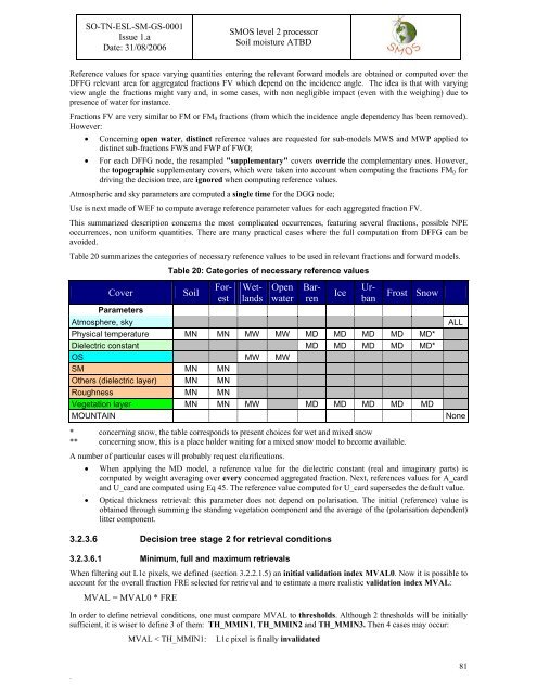
Table 20 summarizes the categories of necessary reference values to be used in relevant fractions and forward models.<br />
Table 20: Categories of necessary reference values<br />
Cover<br />
Parameters<br />
Soil<br />
Open<br />
water<br />
Ice<br />
Forest<br />
Wetlands<br />
Barren<br />
Urban<br />
Frost Snow<br />
Atmosphere, sky<br />
Physical temperature MN MN MW MW MD MD MD MD MD*<br />
Dielectric constant MD MD MD MD MD*<br />
OS MW MW<br />
SM MN MN<br />
Others (dielectric layer) MN MN<br />
Roughness MN MN<br />
Vegetation layer MN MN MW MD MD MD MD MD<br />
MOUNTAIN<br />
ALL<br />
None<br />
* concerning snow, the table corresponds to present choices for wet and mixed snow<br />
** concerning snow, this is a place holder waiting for a mixed snow model to become available.<br />
A number of particular cases will probably request clarifications.<br />
• When applying the MD model, a reference value for the dielectric constant (real and imaginary parts) is<br />
computed by weight averaging over every concerned aggregated fraction. Next, references values for A_card<br />
and U_card are computed using Eq 45. The reference value computed for U_card supersedes the default value.<br />
• Optical thickness retrieval: this parameter does not depend on polarisation. The initial (reference) value is<br />
obtained through summing the standing vegetation component and the average of the (polarisation dependent)<br />
litter component.<br />
3.2.3.6 Decision tree stage 2 for retrieval conditions<br />
3.2.3.6.1 Minimum, full and maximum retrievals<br />
When filtering out L1c pixels, we defined (section 3.2.2.1.5) an initial validation index MVAL0. Now it is possible to<br />
account for the overall fraction FRE selected for retrieval and to estimate a more realistic validation index MVAL:<br />
MVAL = MVAL0 * FRE<br />
In order to define retrieval conditions, one must compare MVAL to thresholds. Although 2 thresholds will be initially<br />
sufficient, it is wiser to define 3 of them: TH_MMIN1, TH_MMIN2 and TH_MMIN3. Then 4 cases may occur:<br />
MVAL < TH_MMIN1:<br />
L1c pixel is finally invalidated<br />
.<br />
81