JeppView : LLBG (27 charts)
JeppView : LLBG (27 charts)
JeppView : LLBG (27 charts)

Create successful ePaper yourself
Turn your PDF publications into a flip-book with our unique Google optimized e-Paper software.
If you like to use this <strong>charts</strong>, please, buy a subscription for nDAC.<br />
For rutracker.org<br />
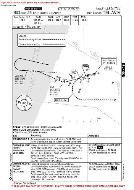
WEF 19 SEP 13<br />
30 - 19<br />
21 AUG 13<br />
Israel - <strong>LLBG</strong> / TLV<br />
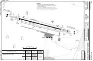
SID RWY 26 EASTBOUND 2 (RADAR) Ben Gurion TEL AVIV<br />
Ben Gurion CLR GND TWR APP DEP TMA ATIS<br />
129.2 118.05 W<br />
129.2 E<br />
132.1 120.5 120.5 119.5 132.5<br />
TA See 10 - 5 AD Elev 134<br />
Legend<br />
Radar Vectoring Route<br />
Comms Failure Route<br />
TMA 8000<br />
2500<br />
9000<br />
2500<br />
TMA<br />
DEENA<br />
D12 BGN<br />
N32 01.6<br />
E034 38.4<br />
TMA APP<br />
<strong>27</strong>0°<br />
8000<br />
TMA APP<br />
1300 AGL<br />
290°<br />
11<br />
8<br />
SIX<br />
D5.5 BGN<br />
N31 59.6<br />
E034 46.3<br />
7<br />
9<br />
6<br />
D2.2<br />
BGN<br />
5<br />
4<br />
12<br />
3<br />
540<br />
254°<br />
10<br />
2<br />
9000<br />
1300 AGL<br />
Ben Gurion<br />
D113.5 BGN<br />
N32 00.8<br />
E034 52.5<br />
1<br />
TMA APP 9000<br />
1300<br />
30 - 19<br />
30<br />
200<br />
BGN<br />
50<br />
MAX 210kt<br />
350<br />
0 5nm<br />
Navtech - llbg19daorg0<br />
SPEED: MAX 250kt below 10000ft unless by ATC.<br />
MNM CLIMB GRADIENT: 7.4% up to 6000<br />
COM: Contact DEP when airborne.<br />
SID Routeing Altitudes<br />
EASTBOUND 2 As soon as practical turn left - intcp R254 BGN and<br />
follow westbound, expect Radar Vectors Eastbound<br />
COMM FAILURE Follow R254 BGN to SIX - turn right on 290° - intcp D7 BGN westbound MNM 3000<br />
PRIOR R<strong>27</strong>0 BGN to DEENA - turn right direct to BGN - For: BGN At 7000<br />
TO RADAR Destinations Southbound: Turn right on R106 BGN - SIVAK southbound At 7000<br />
VECTORS: TALMI - turn right intcp R008 MZD - SIVAK -<br />
SALAM eastbound At 7000<br />
continue to FPL altitude<br />
Destinations Eastbound: Turn right on R095 BGN to<br />
SALAM- continue to FPL altitude.<br />
COMM FAILURE Proceed according to destination as follows,<br />
D6 BGN eastbound MNM 6000<br />
AFTER Destination flights southbound - as soon as possible SIVAK southbound At 7000<br />
RADAR intcp R106 BGN proceed - TALMI and southbound SALAM eastbound At 7000<br />
VECTORS: onto R008 MZD - SIVAK - continue to FPL altitude<br />
Destination flights eastbound as soon as possible<br />
intcp R095 BGN - SALAM - continue eastbound<br />
climbing to FPL altitude.<br />
Change: Renumbered<br />
THIS CHART IS A PART OF NAVIGRAPH CHARTS AND IS INTENDED FOR FLIGHT SIMULATION USE ONLY<br />
Reverse side blank