JeppView : LLBG (27 charts)
JeppView : LLBG (27 charts)
JeppView : LLBG (27 charts)

You also want an ePaper? Increase the reach of your titles
YUMPU automatically turns print PDFs into web optimized ePapers that Google loves.
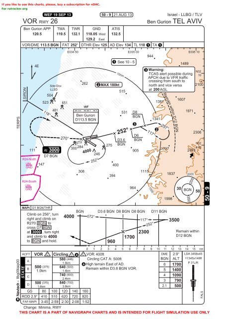
If you like to use this <strong>charts</strong>, please, buy a subscription for nDAC.<br />
For rutracker.org<br />
Navtech -<br />
TERPS<br />
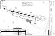
VOR RWY 26<br />
Ben Gurion APP<br />
120.5<br />
TMA<br />
119.5<br />
TWR<br />
132.1<br />
GND<br />
118.05 West<br />
129.2 East<br />
VOR/DME 113.5 BGN FAT 252° DTHR Elev 125 AD Elev 134 TL 110 1 TA 1<br />
SIRON<br />
111<br />
4E<br />
118°<br />
504<br />
D7 BGN<br />
R24-North<br />
UNL 147<br />
GND<br />
R24-South<br />
UNL<br />
GND<br />
MAPt<br />
523<br />
D1 BGN/THR<br />
WEF 19 SEP 13<br />
At<br />
Sde-Dov<br />
LLSD<br />
481<br />
3000<br />
Climb on 256°, turn<br />
right and climb on<br />
R<strong>27</strong>0 BGN to<br />
cross D7 BGN<br />
at 3000 , turn right<br />
and climb to 4000<br />
to BGN and hold.<br />
651<br />
<strong>27</strong>0°<br />
E034 50 E035 00 E035 10<br />
944<br />
4000<br />
300284<br />
262<br />
Ben Gurion<br />
D113.5 BGN<br />
072°<br />
1<br />
2 MAX 180kt<br />
515<br />
531<br />
308 1115<br />
394<br />
BGN<br />
IAF<br />
4000<br />
072°<br />
246<br />
252°<br />
50 - 9<br />
<strong>27</strong>5<br />
21 AUG 13<br />
ATIS<br />
132.5<br />
3<br />
905<br />
964<br />
3 Warning:<br />
N32<br />
TCAS alert possible during 10<br />
APCH due to VFR traffic<br />
crossing from south to<br />
north and vice versa 2100<br />
at 200 AGL<br />
2<br />
1797<br />
1998<br />
1489<br />
1607<br />
1971<br />
2306<br />
N32<br />
00<br />
2493<br />
Remain within<br />
D12 BGN<br />
0 1 2 3 4 5 6 7 8 9 10 11 12 13 14 15 nm<br />
ACFT VOR C Circling C a C VOR: 400ft<br />
DME 2.9° LDA 3458x45<br />
580 (446) Circling CAT A: 500ft<br />
BGN ALT 11345x148ft<br />
A<br />
1.6km a<br />
P 3°L/R<br />
High terrain East of AD.<br />
6 1700<br />
500 (375) 640 (500)<br />
B<br />
Remain within D3.8 BGN VOR.<br />
1.0km 1.6km<br />
5 1400<br />
740 (600)<br />
C<br />
4 1090<br />
2.4km<br />
3 790<br />
500 (375) 840 (700)<br />
D<br />
1.6km<br />
3.6km<br />
2.1 500<br />
GS 80 100 120 140 160<br />
ROD 2.9° 410 510 620 720 820<br />
FAF-MAPt 3:45 2:59 2:30 2:08 1:52<br />
llbg09iaip00<br />
STATE<br />
400<br />
See 10 - 5<br />
Ben Gurion<br />
1000<br />
1381<br />
1341<br />
Israel - <strong>LLBG</strong> / TLV<br />
Remain within D12 BGN<br />
Change: Minima, RWY<br />
THIS CHART IS A PART OF NAVIGRAPH CHARTS AND IS INTENDED FOR FLIGHT SIMULATION USE ONLY<br />
10nm<br />
252°<br />
D3.6<br />
BGN<br />
D8<br />
BGN<br />
D6<br />
BGN<br />
117°<br />
297°<br />
D3.6 BGN D6 BGN D8 BGN D11 BGN<br />
960<br />
1700<br />
117°<br />
2300<br />
252°<br />
1837<br />
TEL AVIV<br />
30<br />
3500<br />
350<br />
2000<br />
200<br />
BGN<br />
50<br />
FALS<br />
50 - 9