
Create successful ePaper yourself
Turn your PDF publications into a flip-book with our unique Google optimized e-Paper software.
68 Zadar county<br />
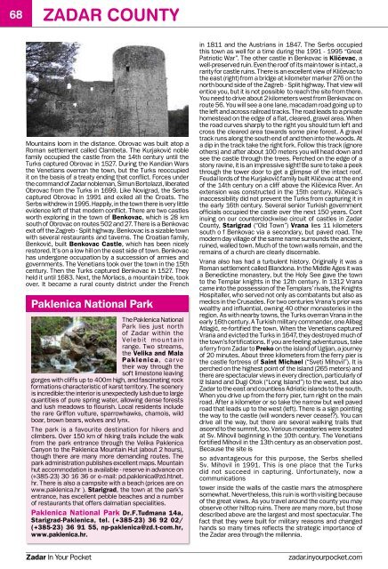
Mountains loom in the distance. Obrovac was built a<strong>to</strong>p a<br />
Roman settlement called Clambeta. The Kurjaković noble<br />
family occupied the castle from the 14th century until the<br />
Turks captured Obrovac in 1527. During the Kandian Wars<br />
the Venetians overran the <strong>to</strong>wn, but the Turks reoccupied<br />
it on the basis of a treaty ending that conflict. Forces under<br />
the command of Zadar nobleman, Šimun Bor<strong>to</strong>lazzi, liberated<br />
Obrovac from the Turks in 1699. Like Novigrad, the Serbs<br />
captured Obrovac in 1991 and exiled all the Croats. The<br />
Serbs withdrew in 1995. Happily, in the <strong>to</strong>wn there is very little<br />
evidence left of that modern conflict. There are two castles<br />
worth exploring in the <strong>to</strong>wn of Benkovac, which is 28 km<br />
south of Obrovac on routes 502 and 27. There is a Benkovac<br />
exit off the Zagreb - Split highway. Benkovac is a sizable <strong>to</strong>wn<br />
with several restaurants and taverns. The Croatian family,<br />
Benković, built Benkovac Castle, which has been nicely<br />
res<strong>to</strong>red. It’s on a low hill on the east side of <strong>to</strong>wn. Benkovac<br />
has undergone occupation by a succession of armies and<br />
governments. The Venetians <strong>to</strong>ok over the <strong>to</strong>wn in the 15th<br />
century. Then the Turks captured Benkovac in 1527. They<br />
held it until 1683. Next, the Morlacs, a mountain tribe, <strong>to</strong>ok<br />
over. It became a rural county district under the French<br />
Paklenica National Park<br />
The Paklenica National<br />
Park lies just north<br />
of Zadar within the<br />
Ve l e b i t m o u n t a i n<br />
range. Two streams,<br />
the Velika and Mala<br />
Paklenica, c a r ve<br />
their way through the<br />
soft limes<strong>to</strong>ne leaving<br />
gorges with cliffs up <strong>to</strong> 400m high, and fascinating rock<br />
formations characteristic of karst terri<strong>to</strong>ry. The scenery<br />
is incredible: the interior is unexpectedly lush due <strong>to</strong> large<br />
quantities of pure spring water, allowing dense forests<br />
and lush meadows <strong>to</strong> flourish. Local residents include<br />
the rare Griffon vulture, sparrowhawks, chamois, wild<br />
boar, brown bears, wolves and lynx.<br />
The park is a favourite destination for hikers and<br />
climbers. Over 150 km of hiking trails include the walk<br />
from the park entrance through the Velika Paklenica<br />
Canyon <strong>to</strong> the Paklenica Mountain Hut (about 2 hours),<br />
though there are many more demanding routes. The<br />
park administration publishes excellent maps. Mountain<br />
hut accommodation is available - reserve in advance on<br />
(+385-23) 30 16 36 or e-mail: pd.paklenica@zd.htnet.<br />
hr. There is also a campsite with a beach (prices are on<br />
www.paklenica.hr ). Starigrad, the <strong>to</strong>wn at the park’s<br />
entrance, has excellent pebble beaches and a number<br />
of restaurants that offers dalmatian specialities.<br />
Paklenica National Park Dr.F.Tuđmana 14a,<br />
Starigrad-Paklenica, tel. (+385-23) 36 92 02/<br />
(+385-23) 36 91 55, np-paklenica@zd.t-com.hr,<br />
www.paklenica.hr.<br />
in 1811 and the Austrians in 1847. The Serbs occupied<br />
this <strong>to</strong>wn as well for a time during the 1991 - 1995 “Great<br />
Patriotic War”. The other castle in Benkovac is Kličevac, a<br />
well-preserved ruin. Even the roof of its main <strong>to</strong>wer is intact, a<br />
rarity for castle ruins. There is an excellent view of Kličevac <strong>to</strong><br />
the east (right) from a bridge at kilometer marker 276 on the<br />
north bound side of the Zagreb - Split highway. That view will<br />
entice you, but it is not possible <strong>to</strong> reach the site from there.<br />
You need <strong>to</strong> drive about 2 kilometers west from Benkovac on<br />
route 56. You will see a one lane, macadam road going up <strong>to</strong><br />
the left and across railroad tracks. The road leads <strong>to</strong> a private<br />
homestead on the edge of a flat, cleared, gravel area. When<br />
the road curves sharply <strong>to</strong> the right you should turn left and<br />
cross the cleared area <strong>to</strong>wards some pine forest. A gravel<br />
track runs along the south end of and then in<strong>to</strong> the woods. At<br />
a dip in the track take the right fork. Follow this track (ignore<br />
others) and after about 100 meters you will head down and<br />
see the castle through the trees. Perched on the edge of a<br />
s<strong>to</strong>ny ravine, it is an impressive sight! Be sure <strong>to</strong> take a peek<br />
through the <strong>to</strong>wer door <strong>to</strong> get a glimpse of the intact roof.<br />
Feudal lords of the Kurjaković family built Kličevac at the end<br />
of the 14th century on a cliff above the Kličevica River. An<br />
extension was constructed in the 15th century. Kličevac’s<br />
inaccessibility did not prevent the Turks from capturing it in<br />
the early 16th century. Several senior Turkish government<br />
officials occupied the castle over the next 150 years. Cont<br />
inuing on our counterclockwise circuit of castles in Zadar<br />
County, Starigrad (“Old Town”) Vrana lies 11 kilometers<br />
south o f Benkovac via a secondary, but paved road. The<br />
modern day village of the same name surrounds the ancient,<br />
ruined, walled <strong>to</strong>wn. Much of the <strong>to</strong>wn walls remain, and the<br />
remains of a church are clearly discernable.<br />
Vrana also has had a turbulent his<strong>to</strong>ry. Originally it was a<br />
Roman settlement called Blandona. In the Middle Ages it was<br />
a Benedictine monastery, but the Holy See gave the <strong>to</strong>wn<br />
<strong>to</strong> the Templar knights in the 12th century. In 1312 Vrana<br />
came in<strong>to</strong> the possession of the Templars’ rivals, the Knights<br />
Hospitaller, who served not only as combatants but also as<br />
medics in the Crusades. For two centuries Vrana’s prior was<br />
wealthy and influential, owning 40 other monasteries in the<br />
region. As with nearby <strong>to</strong>wns, the Turks overran Vrana in the<br />
early 16th century. A Turkish military commander, one Alibeg<br />
Atlagić, re-fortified the <strong>to</strong>wn. When the Venetians captured<br />
Vrana and evicted the Turks in 1647, they destroyed much of<br />
the <strong>to</strong>wn’s fortifications. If you are feeling adventurous, take<br />
a ferry from Zadar <strong>to</strong> Preko on the island of Ugljan, a journey<br />
of 20 minutes. About three kilometers from the ferry pier is<br />
the castle fortress of Saint Michael (“Sveti Mihovil”). It is<br />
perched on the highest point of the island (265 meters) and<br />
there are spectacular views in every direction, particularly of<br />
Iž Island and Dugi O<strong>to</strong>k (“Long Island”) <strong>to</strong> the west, but also<br />
Zadar <strong>to</strong> the east and countless Adriatic islands <strong>to</strong> the south.<br />
When you drive up from the ferry pier, turn right on the main<br />
road. After a kilometer or so take the narrow but well paved<br />
road that leads up <strong>to</strong> the west (left). There is a sign pointing<br />
the way <strong>to</strong> the castle (will wonders never cease!?). You can<br />
drive all the way, but there are several walking trails that<br />
ascend <strong>to</strong> the summit, <strong>to</strong>o. Various monasteries were located<br />
at Sv. Mihovil beginning in the 10th century. The Venetians<br />
fortified Mihovil in the 13th century as an observation post.<br />
Because the site is<br />
so advantageous for this purpose, the Serbs shelled<br />
Sv. Mihovil in 1991. This is one place that the Turks<br />
did not succeed in capturing. Unfortunately, now a<br />
communications<br />
<strong>to</strong>wer inside the walls of the castle mars the atmosphere<br />
somewhat. Nevertheless, this ruin is worth visiting because<br />
of the great views. As you travel around the county you may<br />
observe other hill<strong>to</strong>p ruins. There are many more, but those<br />
described above are the largest and most spectacular. The<br />
fact that they were built for military reasons and changed<br />
hands so many times reflects the strategic importance of<br />
the Zadar area through the millennia.<br />
Zadar In Your Pocket<br />
zadar.inyourpocket.com