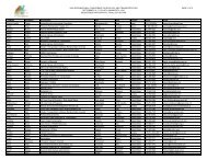
Poster Sessions, pages 567-640 - ICOET
Poster Sessions, pages 567-640 - ICOET
Poster Sessions, pages 567-640 - ICOET

You also want an ePaper? Increase the reach of your titles
YUMPU automatically turns print PDFs into web optimized ePapers that Google loves.
Forest Service Back Roads: Utilization of GPS/GIS Technology for Acquiring Road Infrastructure<br />
Data in the Ozark-St. Francis National Forests<br />
Abstract<br />
Benjamin Gentry, GIS Technician (479-964-7200, bgentry@fs.fed.us), Ozark-St. Francis National<br />
Forest, 605 West Main St., Russellville, AR 72801 USA<br />
This presentation describes how one Forest Service unit uses GPS/GIS technology to update and maintain information<br />
regarding its road network.<br />
The Ozark-St. Francis National Forest (OSFNF) has developed an integrated field collection and GIS process method to<br />
digitally capture spatial and tabular information about travel routes, road features, travel route conditions, and other<br />
related features, to assist in land management planning activities and environmental assessments.<br />
The methodology draws from 5+ years of experience incurred by the Ouachita National Forest, The Nature<br />
Conservancy, and the Watershed Conservation Resource Center to inventory road locations and prioritize maintenance<br />
recommendations. These earlier activities were useful for updating Forest Service applications, or collecting variable<br />
for use in environmental prediction models such as WEPP: Road.<br />
Currently the USFS maintains road information in an Oracle database accessed through an application known as INFRA<br />
travel routes which interfaces with an Electronic Road Log (ERL) for conducting automated updates. This tool makes<br />
available changes to tabular information fields but does not support spatial updates to GIS data layers. The methodology<br />
described in this project is manual; however the intent is an expanded amount of highly organized tabular and<br />
spatial information, collected in the field, using a standard suite of hardware/software components. These features<br />
make this methodology appropriate for dissemination to other FS units, and could easily be automated as a one-click<br />
update tool.<br />
The OSFNF methodology uses Trimble Geoexplorer GPS units and a custom data dictionary for the collection and<br />
organization of tabular and spatial information. Post-processing methods that remove errors, correct for spatial requirements,<br />
provide QA/QC, and format the output products are clearly defined. This output is then migrated into applications<br />
such as INFRA travel routes; INFRA travel route GIS data layers, and forest specific datasets that accommodate<br />
related information. This methodology allows the OSFNF to maintain databases and GIS layers to the appropriate<br />
standards while providing an expanded dataset of road related features for land and resource management planning.<br />
The goals of this project are to increase the spatial accuracy of road related data and to develop a tool where multiskilled<br />
users can generate consistent outputs for this type of information. This project also seeks a method for updating<br />
tabular INFRA data and spatial GIS data layers simultaneously in order to increase the efficiency of field inventories.<br />
Ultimately, updating travel route information without ERL hardware requisites, increasing the intensity of field inventories,<br />
and achieving greater consistency will expand the OSFNF capabilities for conducting environmental assessments<br />
and opportunity analysis.<br />
Bridging the Gaps, Naturally 601 <strong>Poster</strong>s