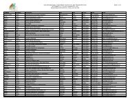
Poster Sessions, pages 567-640 - ICOET
Poster Sessions, pages 567-640 - ICOET
Poster Sessions, pages 567-640 - ICOET

Create successful ePaper yourself
Turn your PDF publications into a flip-book with our unique Google optimized e-Paper software.
Abstract<br />
An Analytical Framework for Wildlife Crossing Policy in California<br />
Amy Pettler (916-651-8166, amy_pettler@dot.ca.gov), Senior Endangered Species Coordinator and<br />
Wildlife Biologist, and<br />
Gregg Erickson (916-654-6296, gregg_erickson@dot.ca.gov), Division of Environmental Analysis,<br />
California Department of Transportation, 1120 N Street, MS 27, Sacramento, CA 94274 USA<br />
James Quinn (530-752-8027, jfquinn@ucdavis.edu),<br />
Robert Meese (rjmeese@ucdavis.edu), and<br />
Fraser Shilling (fmshilling@ucdavis.edu), Department of Environmental Science and Policy, University<br />
of California, Davis, CA 95695 USA<br />
This abstract reports on the results of a California joint DOT-university project to develop database, modeling, and GIS<br />
tools and to publish an electronic manual and digital library to address animal-vehicle collision reduction and connectivity<br />
issues in the state.<br />
Despite the potentially large impacts of roads on wildlife movements and mortality, California has historically lacked<br />
standardized information tools to enable wildlife and transportation planners and managers to best identify and mitigate<br />
those impacts. These issues are being addressed by several California Department of Transportation research<br />
and development initiatives, including Animal Vehicle Collision Reduction and Connectivity Issues, Fish Passage, and<br />
Advanced Mitigation, much in collaboration with the University of California. Goals include addressing:<br />
• Developing Useful Metrics, Standardizing Data Collection Techniques and Data Analysis Models/Tools for<br />
Assessment<br />
• Improving Safety and Delivery in the Caltrans Planning and Project Development Process<br />
• Strategic Outreach and Engagement<br />
• Development of Guidance Documents and Support Tools for Analysis based on the developed Metrics,<br />
Standards, and models<br />
• Working at a program level to optimize and leverage funding opportunities for collision reduction and connectivity<br />
issues<br />
Elements of a new analytic framework to address this need include integrative GIS tools to identify, on both local<br />
and regional scales, locations of core wildlife populations, mapping of least-cost-path movement corridors to identify<br />
locations posing high risks of crossing mortality, a library of species-specific information on movement patterns and<br />
models, tools to develop more systematic documentation of road-related wildlife mortality, and a clearinghouse for<br />
evaluating structures, technologies and networking approaches to remotely detecting the presence of wildlife around<br />
transportation facilities, evaluating impacts, and mitigating the effects. Improved data from remote sensing and GIS<br />
clearinghouses, new methods and sensors for detecting animals and movement, emerging technologies for networking<br />
distributed and heterogeneous data, new data standards and models, and better integration with other information<br />
sources can all contribute to decreasing road impacts on animal populations and movements. Results of this project<br />
include a newly published California manual for managing wildlife crossing issues and GIS, database, and supporting<br />
digital library tools on-line at the Information Center for the Environment (http://ice.ucdavis.edu).<br />
Bridging the Gaps, Naturally 623 <strong>Poster</strong>s