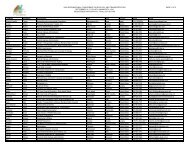
Poster Sessions, pages 567-640 - ICOET
Poster Sessions, pages 567-640 - ICOET
Poster Sessions, pages 567-640 - ICOET

You also want an ePaper? Increase the reach of your titles
YUMPU automatically turns print PDFs into web optimized ePapers that Google loves.
Abstract<br />
Development of a Bald Eagle Habitat Assessment Tool and Its Application in Highway Planning<br />
James Hatchitt, GIS Project Manager (352-333-8393, jim@armasi.com), ARMASI, Inc., 3966 SW 98th<br />
Dr., Gainesville, FL 32608 USA<br />
Florida has the largest population of nesting bald eagles (Haliaeetus leucocephalus) in the Continental US. Bald eagles<br />
are currently listed as a federal and state threatened species. The bald eagle population in Florida has recovered to<br />
the point that the US Fish & Wildlife Service (USFWS) has indicated that it no longer warrants protection under the<br />
Endangered Species Act (ESA). However the species will continue to be managed and protected by federal and state<br />
guidelines. Until recently application of management guidelines could only be based on subjective assessment of the<br />
individual nest site. Habitat management guidelines have been developed and successfully implemented to accommodate<br />
human and bald eagle habitat needs on a limited basis. Here we are describing a data based model which<br />
was used to assess each nest site in Florida based on its current and future comparative importance to the population.<br />
The results of this process are then overlaid on the Florida Intrastate Highway System (FIHS) map layer. This provides<br />
a mechanism whereby the Florida Department of Transportation (FDOT) has advanced warning of potential issues<br />
relating to bald eagle habitat.<br />
The Florida Department of Transportation (FDOT) and FFWCC has worked cooperatively through a contract with<br />
ARMASI Inc. to develop a Bald Eagle Habitat Index of Vulnerability (BEHIV) environmental management tool. This<br />
vulnerability index evaluates each eagle nesting site in Florida to provide a quantitative assessment of the current and<br />
predicted effects of various anthropogenic and natural modifications to the long term viability of these sites. Multiple<br />
habitat aspects associated with each nest site, including land use, distance to water, and density or proximity of nest<br />
habitat areas, were systematically grouped into data layers. The various layers used in the construction of the BEHIV<br />
were incorporated into the model through a weighting process based on their relative importance to eagle nest viability<br />
(Nesbitt et al. manuscript). The weighted value assigned to each layer was developed through the review of historical<br />
data, ongoing studies, and expert opinions. The relative score compiled from the model and associated map data was<br />
used to delineate the various habitat constraints and resources associated with each of the more than 1200 nest<br />
sites in Florida. This natural setting score provides a characterization of the quality of each habitat area based on the<br />
weighted data variables compiled.<br />
In addition to the natural setting profile an evaluation of the potential for future disruption was compiled using a<br />
Conservation Land and Future Land Use coverage with a similar weighting scheme. The amount of area for each future<br />
land use or proposed zoning land use categories contained within each habitat buffer was calculated and summarized<br />
to arrive at a potential for disruption score.<br />
This qualitative ranking process and the database of individual component values for each nest offers a consistent<br />
means of ranking habitat areas across the state. The results of this analysis are used to determine the number of<br />
nests within a certain distance of the FIHS system along with their associated BEHIV score. We created a buffer file<br />
for each FIHS segment. The resulting buffer files were then overlain on the Eagle nest BEHIV file and the two files<br />
were then merged and summarized by FIHS segment to get a preliminary BEHIV score for each segment. Three buffer<br />
distances are used to indicate the potential for disruption of nest in proximity to the FIHS network. The buffer distances<br />
are a 750 feet Primary Alert buffer, a 1500 feet Secondary Alert buffer, and a 1 mile notification buffer (these distances<br />
are expected to be reduced once the species has been delisted).<br />
The results of this project are intended to compliment existing information related to the FIHS maintenance and right<br />
of way development. The incorporation of the BEHIV/ASSESS into the FIHS provides a means by which FDOT personnel<br />
can be alerted to environmental concerns at an early stage in the planning process. This project and its application<br />
offers some insight to the potential for adding other environmental layers to FDOT planning areas. The results have<br />
been submitted to FDOT and the BEHIV process is currently under review by FFWCC staff for incorporation into the Bald<br />
Eagle Management Plan.<br />
Bridging the Gaps, Naturally 603 <strong>Poster</strong>s