tentative map application submittal requirements - City of Temecula
tentative map application submittal requirements - City of Temecula
tentative map application submittal requirements - City of Temecula
You also want an ePaper? Increase the reach of your titles
YUMPU automatically turns print PDFs into web optimized ePapers that Google loves.
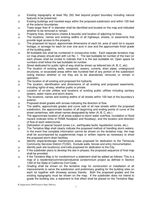
Existing topography at least fifty (50) feet beyond project boundary including natural<br />
features to be preserved<br />
Existing buildings and traveled ways within the proposed subdivision and within 100 feet<br />
<strong>of</strong> the exterior boundaries.<br />
Trees larger than 6" in diameter shall be identified and located on the <strong>map</strong> and indicated<br />
whether to be removed or remain.<br />
Property lines, dimensions (metes & bounds) and location <strong>of</strong> adjoining lot lines.<br />
The locations, names and existing widths <strong>of</strong> all highways, streets, or easements that<br />
provide legal access to the property.<br />
The proposed lot layout, approximate dimensions <strong>of</strong> each lot, area <strong>of</strong> each lot in square<br />
footage, or acreage for each lot over one acre in size and the approximate finish grade<br />
<strong>of</strong> the building pads.<br />
All buildable lots shall be numbered in consecutive order. Each separate <strong>tentative</strong> <strong>map</strong><br />
(or <strong>map</strong> phase) should start with Lot No. 1. The last buildable lot number <strong>of</strong> the tract (or<br />
each phase) shall be circled to indicate that it is the last buildable lot. Open space lot<br />
numbers shall follow the last buildable lot number.<br />
Street dedicated for public right-<strong>of</strong>-way shall be shown as lettered lots (A, B, C, etc)<br />
The location <strong>of</strong> existing wells, cesspools, sewers, culverts, drain pipes, underground<br />
structures, or excavated areas within two hundred feet <strong>of</strong> any portion <strong>of</strong> the subdivision<br />
noting thereon whether or not they are to be abandoned, removed, or remain in<br />
operation.<br />
The location <strong>of</strong> all existing and proposed fire hydrants.<br />
The location, identification and dimensions <strong>of</strong> all existing and proposed easements,<br />
including rights-<strong>of</strong>-way, whether public or private.<br />
Location <strong>of</strong> on-site utilities and locations <strong>of</strong> existing public utilities including sanitary<br />
sewers, water mains and storm drains.<br />
The locations, names and existing widths <strong>of</strong> all streets within 100 feet <strong>of</strong> the boundary’s<br />
exterior.<br />
Proposed street grades with arrows indicating the direction <strong>of</strong> flow.<br />
The widths, approximate grades and curve radii <strong>of</strong> all new streets within the proposed<br />
subdivision, the approximate location <strong>of</strong> all beginning and ending points <strong>of</strong> curve <strong>of</strong> the<br />
street centerlines, with street names designated by letter (A, B, C, etc.).<br />
The approximate location <strong>of</strong> all areas subject to storm water overflow, inundation or flood<br />
hazard (indicate limits <strong>of</strong> FEMA floodplain and floodway), and the location and direction<br />
<strong>of</strong> flow <strong>of</strong> each watercourse.<br />
Delineation <strong>of</strong> special hazard zones (i.e., earthquake faults, liquefaction zones, etc.).<br />
The Tentative Map shall clearly indicate the proposed method <strong>of</strong> handling storm waters.<br />
In the event that complete information cannot be shown on the <strong>tentative</strong> <strong>map</strong>, the <strong>map</strong><br />
shall be accompanied by supplemental <strong>map</strong>s or written reports as necessary to show<br />
the proposed storm drain facilities.<br />
Identify slope/landscape maintenance areas proposed for dedication to the <strong>Temecula</strong><br />
Community Services District (TCSD). Exclude walls, fences and entry monumentation.<br />
Identify park site location(s) and trails proposed for dedication to the <strong>City</strong>.<br />
If the subdivider plans to develop the site in phases, the proposed sequence <strong>of</strong> final <strong>map</strong><br />
shall be provided.<br />
If the Tentative Map is for condominium a statement shall be added as follows: This is a<br />
<strong>map</strong> <strong>of</strong> a residential/commercial/industrial condominium project as defined in Section<br />
1350 <strong>of</strong> the State <strong>of</strong> California Civil Code.<br />
Grading shall be shown on the <strong>tentative</strong> <strong>map</strong> for construction or installation <strong>of</strong> all<br />
improvements to serve the subdivision and preliminary grading for the building sites on<br />
each lot together with driveway access thereto. Both the proposed grades and the<br />
existing topography must be shown on the <strong>map</strong>. If the subdivider does not intend to<br />
grade the building site, a statement to that effect shall be placed on the Tentative Map.<br />
R:\Applications 2008\Tentative Maps 2008.doc<br />
7


