2001â2002 - California Sea Grant - UC San Diego
2001â2002 - California Sea Grant - UC San Diego
2001â2002 - California Sea Grant - UC San Diego

Create successful ePaper yourself
Turn your PDF publications into a flip-book with our unique Google optimized e-Paper software.
account the influence of the large-scale flows on eddies. Both schemes<br />
present inherent limitations, since the major currents and eddies do not<br />
exist separately from each other but instead interact and evolve together.<br />
In their current <strong>Sea</strong> <strong>Grant</strong> project, Stolzenbach and McWilliams have<br />
developed a model that simulates the effects of large-scale flows on local<br />
circulation patterns. To do this, they have produced a mathematical<br />
algorithm that effectively gives them a zoom lens for viewing details along<br />
the coast. To produce this zoom, output from a regional circulation model<br />
is used to initialize and set boundary conditions for a series of embedded,<br />
or nested, calculations. It is these embedded calculations that capture the<br />
effects of the <strong>California</strong> Current system on local circulation patterns. At<br />
present, their model telescopes from a 100-kilometer scale to a 1-kilometer<br />
scale in the Southern <strong>California</strong> Bight.<br />
The regional model, it should be noted, was developed in a previous <strong>Sea</strong><br />
<strong>Grant</strong> project in collaboration with researchers at Rutgers University in<br />
New Brunswick, New Jersey.<br />
To check the accuracy of their model, the scientists are comparing their<br />
simulations to real ocean data collected by a variety of sources, including<br />
NASA satellite measurements of sea surface temperature, sea level and<br />
ocean color. So far, their computations compare favorably to real observations.<br />
The model continues to be fine-tuned as the project is only in its second<br />
year. The scientists will incorporate tidal currents and municipal sewage<br />
discharge data into the model to help them track the movement of treated<br />
sewage along the coast. They also plan to simulate the dispersion of runoff<br />
after heavy winter storms. And, because the model incorporates data on<br />
nitrogen, chlorophyll, and zooplankton abundance, it will also be possible<br />
to look at some of the very simple biogeochemical interactions between<br />
upwelling events and phytoplankton blooms.<br />
Another ambitious goal is to work out the physics of sediment transport<br />
in the bays. This will require resolving even smaller-scale motions, since<br />
sediments are carried by ocean waves and by currents set up by breaking<br />
waves. The scientists are currently<br />
collecting geologic information to help<br />
them estimate the grain size of particles<br />
on the sea floor, a key factor in determining<br />
how far sediments are carried by<br />
waves and currents. They also are<br />
similarly modeling<br />
flows in the<br />
Monterey Bay.<br />
Keith Stolzenbach is a<br />
professor in the Department of<br />
Civil and Environmental<br />
Engineering at <strong>UC</strong>LA. Photo:<br />
<strong>UC</strong>LA<br />
Their project is<br />
scheduled to be<br />
completed in<br />
February of<br />
2004.<br />
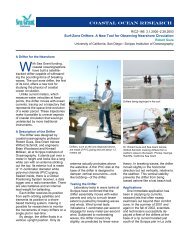
<strong>Sea</strong> <strong>Grant</strong> researchers modified a computer simulation of currents along the<br />
West Coast to model flows within the Southern <strong>California</strong> Bight. The above<br />
shows a plot of simulated water velocities (the vectors) over a contour plot<br />
of sea-surface temperature. Image from: Marchesiello, McWilliams, Oram,<br />
and Stolzenbach<br />
James McWilliams is the<br />
Louis B. Slichter Professor of<br />
Earth Sciences in the<br />
Department of Atmospheric<br />
Sciences at <strong>UC</strong>LA. Photo:<br />
<strong>UC</strong>LA<br />
21