Geophysical Survey in Archaeological Field Evaluation - HELM
Geophysical Survey in Archaeological Field Evaluation - HELM
Geophysical Survey in Archaeological Field Evaluation - HELM

Create successful ePaper yourself
Turn your PDF publications into a flip-book with our unique Google optimized e-Paper software.
Part IV Practitioner’s Guide to<br />
Good Practice<br />
1 Application of techniques<br />
1.1 The survey grid<br />
<strong>Geophysical</strong> fieldwork relies on the presence<br />
of an accurately plotted network of control<br />
po<strong>in</strong>ts extend<strong>in</strong>g across the area to be worked<br />
on and this is usually referred to as the survey<br />
grid. An <strong>in</strong>ternally accurate and correctly<br />
georeferenced grid is crucial to all subsequent<br />
survey and to the whole project outcome: close<br />
attention to this fundamental stage of fieldwork<br />
is therefore essential. Recent developments<br />
<strong>in</strong>volv<strong>in</strong>g mobile sensor platforms <strong>in</strong>corporat<strong>in</strong>g<br />
real time global position<strong>in</strong>g system (GPS)<br />
sensors mean that it is no longer always<br />
necessary to establish a conventional grid of<br />
fixed markers over the surface of the area to<br />
be surveyed (see below, section 1.1.2). When<br />
employ<strong>in</strong>g such technologies, survey teams<br />
should recognise that a grid of control po<strong>in</strong>ts<br />
capable of accurately def<strong>in</strong><strong>in</strong>g the boundaries<br />
of the area surveyed is still required even if<br />
not actually laid out with ground markers<br />
before or dur<strong>in</strong>g the geophysical survey.<br />
However the survey grid is located, dur<strong>in</strong>g<br />
fieldwork a record should be made relative to<br />
it of surface conditions and sources of modern<br />
geophysical <strong>in</strong>terference that might have a bear<strong>in</strong>g<br />
on subsequent <strong>in</strong>terpretation of field data.<br />
1.1.1 Conventional survey grids<br />
Establish<strong>in</strong>g and mark<strong>in</strong>g out the survey grid<br />
are usually the responsibility of the project<br />
manager, although this should be discussed<br />
and clarified with the geophysical survey team<br />
<strong>in</strong>volved. The grid can be laid out by any<br />
suitably qualified personnel with the agreement<br />
of (and, if necessary, follow<strong>in</strong>g the <strong>in</strong>structions<br />
of) the geophysical surveyors. Considerations<br />
of geophysical methodology or ground response<br />
may well dictate a preferred grid alignment,<br />
particularly when the alignment of l<strong>in</strong>ear features<br />
is already known. In this regard, Gaffney and<br />
Gater (2003, 85–8) provide a concise review<br />
of the issues common to most archaeological<br />
geophysical surveys.<br />
Where deadl<strong>in</strong>es are tight, a previously surveyed<br />
grid will allow the <strong>in</strong>com<strong>in</strong>g geophysical survey<br />
team to concentrate their specialist time to<br />
greater effect. Where more time is available,<br />
they may otherwise wish to provide the<br />
survey grid themselves. Whoever lays out the<br />
grid, it is important that its <strong>in</strong>ternal accuracy<br />
and measurements to fixed topographic po<strong>in</strong>ts<br />
are rigorously and <strong>in</strong>dependently checked.<br />
<strong>Geophysical</strong> survey teams are advised always<br />
to check the accuracy of previously surveyed<br />
grids and to take <strong>in</strong>dependent measurements<br />
for grid location. There can be no excuse<br />
whatsoever for any subsequent mismatches<br />
between different parts of a geophysical survey,<br />
or other positional confusion. It is preferable<br />
and convenient, but not essential, for the<br />
geophysical survey grid to match exactly<br />
the Ordnance <strong>Survey</strong> National Grid (see<br />
for example English Heritage 2003) or a site<br />
grid devised for other purposes, such as field<br />
walk<strong>in</strong>g. The need to fit a survey <strong>in</strong>to exist<strong>in</strong>g<br />
boundaries may dictate the use of a different<br />
grid, however. If more than one grid must be<br />
used, accurate location of each will be critical<br />
for the subsequent <strong>in</strong>tegration of results.<br />
A unit of either 20m or 30m for the side of<br />
each grid square is usual (although some survey<br />
methodologies may use a different optimal<br />
base survey unit), with grid <strong>in</strong>tersections located<br />
on the ground us<strong>in</strong>g wooden pegs or other<br />
temporary markers, which must be non-magnetic<br />
for magnetometer surveys. Because of the many<br />
hazards <strong>in</strong>volved, not least of which concern<br />
the safety of people and animals, the choice<br />
of markers and their duration <strong>in</strong> the ground<br />
needs careful forethought as well as the<br />
agreement of the landowner and/or tenant<br />
(see also Part I, 7.1).<br />
The grid must be laid out us<strong>in</strong>g currently<br />
accepted conventional methods (eg Bettess<br />
1992; Bowden 1999; Clark 1996).<br />
For long grid l<strong>in</strong>es, <strong>in</strong> excess of 100m, the use<br />
of a theodolite, EDM total station or GPS is<br />
advisable. For smaller grids, the use of an optical<br />
square is acceptable (eg English Heritage 2002).<br />
English Heritage (2003, 8–9) provides a useful<br />
summary of the different types of measurement<br />
accuracy associated with survey grids, def<strong>in</strong><strong>in</strong>g<br />
relative, map and absolute accuracy. Us<strong>in</strong>g any<br />
of the aforementioned techniques it should be<br />
possible to locate the grid control po<strong>in</strong>ts on<br />
the ground to a relative accuracy of ±0.1m.<br />
GPS equipment is becom<strong>in</strong>g <strong>in</strong>creas<strong>in</strong>gly available<br />
and English Heritage (2003) addresses the<br />
issues associated with its use for archaeological<br />
survey, classify<strong>in</strong>g the various types of GPS<br />
system accord<strong>in</strong>g to the positional accuracy<br />
that can be achieved (navigation-grade, mapgrade<br />
and survey-grade). <strong>Survey</strong>-grade GPS,<br />
capable of absolute positional accuracy of ±0.1m<br />
(either <strong>in</strong> real time or with post-process<strong>in</strong>g),<br />
is the only grade suitable for locat<strong>in</strong>g survey<br />
grid control po<strong>in</strong>ts. It should be noted that<br />
the positional accuracy of exist<strong>in</strong>g base maps<br />
may be lower, depend<strong>in</strong>g on how they were<br />
orig<strong>in</strong>ally created (see English Heritage 2003,<br />
8–9). Bear<strong>in</strong>g this <strong>in</strong> m<strong>in</strong>d, it is advisable when<br />
us<strong>in</strong>g GPS to locate the survey grid to measure<br />
the positions of some fixed local landmarks or<br />
boundaries recorded on the area base map<br />
and not just record the temporary survey<br />
grid po<strong>in</strong>ts. Any discrepancies between GPS<br />
position<strong>in</strong>g and local base mapp<strong>in</strong>g can then<br />
be compensated for and it is also possible to<br />
re-establish the grid <strong>in</strong>dependently relative to<br />
the measured landmarks.<br />
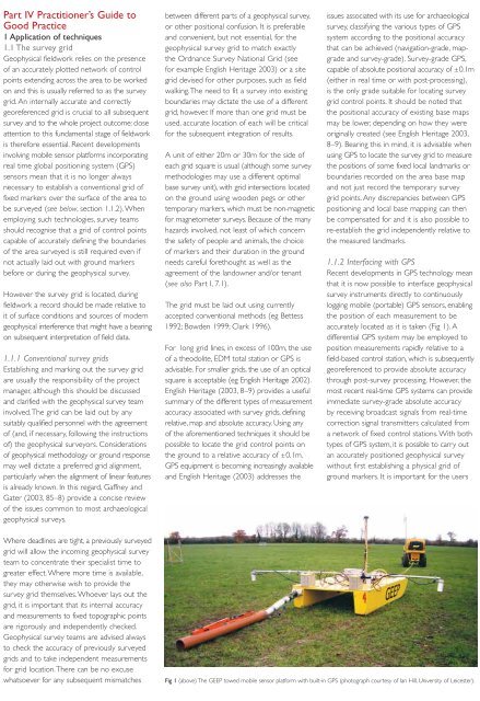
1.1.2 Interfac<strong>in</strong>g with GPS<br />
Recent developments <strong>in</strong> GPS technology mean<br />
that it is now possible to <strong>in</strong>terface geophysical<br />
survey <strong>in</strong>struments directly to cont<strong>in</strong>uously<br />
logg<strong>in</strong>g mobile (portable) GPS sensors, enabl<strong>in</strong>g<br />
the position of each measurement to be<br />
accurately located as it is taken (Fig 1). A<br />
differential GPS system may be employed to<br />
position measurements rapidly relative to a<br />
field-based control station, which is subsequently<br />
georeferenced to provide absolute accuracy<br />
through post-survey process<strong>in</strong>g. However, the<br />
most recent real-time GPS systems can provide<br />
immediate survey-grade absolute accuracy<br />
by receiv<strong>in</strong>g broadcast signals from real-time<br />
correction signal transmitters calculated from<br />
a network of fixed control stations. With both<br />
types of GPS system, it is possible to carry out<br />
an accurately positioned geophysical survey<br />
without first establish<strong>in</strong>g a physical grid of<br />
ground markers. It is important for the users<br />
Fig 1 (above) The GEEP towed mobile sensor platform with built-<strong>in</strong> GPS (photograph courtesy of Ian Hill, University of Leicester).<br />
19