Geophysical Survey in Archaeological Field Evaluation - HELM
Geophysical Survey in Archaeological Field Evaluation - HELM
Geophysical Survey in Archaeological Field Evaluation - HELM

Create successful ePaper yourself
Turn your PDF publications into a flip-book with our unique Google optimized e-Paper software.
8<br />
● ground/vegetation conditions at the time<br />
of the survey<br />
● ownership<br />
<strong>Survey</strong> location: a map of a suitable scale<br />
to show the context, location and size of<br />
the proposed survey area(s).<br />
The geophysical survey requirement: this will<br />
state the objectives of the geophysical survey<br />
and the methodology by which these are<br />
<strong>in</strong>tended to be achieved. The detail of the<br />
required methodology will be provided <strong>in</strong> a<br />
separate specification (which may follow as<br />
part of a comb<strong>in</strong>ed Brief and Specification).<br />
In the meantime it is sufficient to identify that<br />
geophysical survey is required, although a<br />
more specific methodology can be <strong>in</strong>dicated,<br />
for example:<br />
● earth resistance area survey<br />
● detailed magnetometer area survey<br />
● detailed GPR area survey<br />
● GPR profiles<br />
Timetable: a statement or tabulation of the<br />
project timetable, emphasis<strong>in</strong>g the schedul<strong>in</strong>g<br />
of fieldwork and report presentation.<br />
Further <strong>in</strong>formation: anyth<strong>in</strong>g further of broad<br />
relevance to enabl<strong>in</strong>g the survey work.<br />
3.2 The Specification<br />
More specific and detailed survey requirements<br />
are described <strong>in</strong> The Specification. This will<br />
usually be separate from the preced<strong>in</strong>g brief,<br />
but if circumstances permit, the two may be<br />
comb<strong>in</strong>ed as part of the same document.<br />
The specification should <strong>in</strong>clude the follow<strong>in</strong>g:<br />
Summary: a resumé of the <strong>in</strong>formation<br />
provided by the brief.<br />
<strong>Survey</strong> location: an annotated map or plan<br />
<strong>in</strong>dicat<strong>in</strong>g which areas are to be surveyed.<br />
If different areas require differ<strong>in</strong>g survey<br />
methodologies, then these should be <strong>in</strong>dicated if<br />
possible. The map can also be used to provide<br />
other important <strong>in</strong>formation (eg access routes)<br />
where necessary.<br />
The survey grid/co-ord<strong>in</strong>ate system: the<br />
follow<strong>in</strong>g needs to be identified:<br />
● a temporary/permanent survey grid is to<br />
be established<br />
● responsibility for do<strong>in</strong>g so (usually the<br />
survey team)<br />
● accurate location of grid <strong>in</strong>tersections (±0.1m)<br />
● georeferenc<strong>in</strong>g (measurements to permanent<br />
features to allow the grid to be exactly<br />
re-located if necessary by a third party)<br />
<strong>Survey</strong> type: a statement of the geophysical<br />
technique to be used – examples might be:<br />
● fluxgate gradiometer area survey<br />
● alkali-vapour magnetometer area survey<br />
● earth resistance area survey<br />
● EM soil conductivity area survey<br />
● GPR profil<strong>in</strong>g<br />
● GPR area survey<br />
<strong>Survey</strong> <strong>in</strong>strumentation: it is not usually<br />
necessary to specify the make or model of<br />
equipment (however, these should be stated<br />
<strong>in</strong> the result<strong>in</strong>g survey report).<br />
GPR equipment must be suitable to meet<br />
the required specification, specifically any<br />
requirements for the centre frequency of the<br />
antenna(s) to be used and the necessity for<br />
antenna shield<strong>in</strong>g. Note that, should topographic<br />
correction be a requirement of this or any<br />
other type of survey, care must be taken that<br />
this is accounted for and costed as appropriate.<br />
<strong>Survey</strong> methodology: a statement of<br />
methodology. For example: all methodologies<br />
will follow those recommended <strong>in</strong> the<br />
appropriate operators’ manuals for:<br />
● traverse/l<strong>in</strong>e separation<br />
● probe configuration (earth resistance surveys)<br />
● mobile probe spac<strong>in</strong>g (earth resistance surveys)<br />
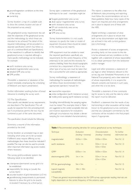
Sampl<strong>in</strong>g <strong>in</strong>terval/density: the sampl<strong>in</strong>g regime<br />
must be stated. The examples listed <strong>in</strong> Table 1<br />
are suggested as the widest acceptable <strong>in</strong>tervals<br />
and traverse separations for evaluations<br />
(although circumstances may dictate a denser<br />
sampl<strong>in</strong>g for more detailed characterisations).<br />
The report: a statement to the effect that<br />
all fieldwork, data process<strong>in</strong>g and report<strong>in</strong>g<br />
must follow the recommendations set out <strong>in</strong><br />
these guidel<strong>in</strong>es. State how many copies of the<br />
report are required, and what arrangements<br />
are <strong>in</strong> place to deposit one of these with<br />
the HER.<br />
Digital archiv<strong>in</strong>g: a statement of what<br />
arrangements are <strong>in</strong> place to ensure that<br />
both survey documentation and digital data<br />
are archived <strong>in</strong> l<strong>in</strong>e with current guidance<br />
(see 6 Archiv<strong>in</strong>g).<br />
Access: a statement of access arrangements,<br />
provid<strong>in</strong>g clarity on how access to the site<br />
is to be achieved, and any conditions on this,<br />
together with a statement of whose responsibility<br />
it is to obta<strong>in</strong> permission from the landowner<br />
and/or manager.<br />
Legal and other provisions: a statement of<br />
any legal or other limitations relevant to the<br />
survey (eg over Scheduled Monuments or on<br />
National Trust property), and a clear statement<br />
of whose responsibility it is to acquire the<br />
relevant consents and licences <strong>in</strong> such cases,<br />
and when this is to be done.<br />
Timetable: a statement of time constra<strong>in</strong>ts<br />
(eg for access to site), and the date by when<br />
the report must be delivered.<br />
Feedback: a statement that the results of any<br />
trial trench<strong>in</strong>g or other excavation will be made<br />
known to the geophysical survey contractor,<br />
and that any subsequent commentary by the<br />
contractor, will be <strong>in</strong>cluded <strong>in</strong> the f<strong>in</strong>al project<br />
report, if appropriate.<br />
Table 1 Recommended sampl<strong>in</strong>g densities for various geophysical survey techniques.<br />
Technique <strong>Evaluation</strong> Characterisation For further<br />
(read<strong>in</strong>g x traverse) (read<strong>in</strong>g x traverse) <strong>in</strong>formation see<br />
magnetometer 0.25m x 1.0m 0.25m x 0.5m Part IV, 1.2<br />
earth resistance 1m x 1m 0.5m x 1m or Part IV, 1.3<br />
0.5m x 0.5m<br />
GPR* 0.05m x 1m 0.05m x 0.5m Part IV, 1.4<br />
electromagnetic (EM) 1m x 1m 0.5m x 1m or Part IV, 1.5<br />
0.5m x 0.5m<br />
EM for geomorphology 5m x 5m – Part IV, 1.5<br />
topsoil magnetic 10m x 10m – Part IV, 1.6<br />
susceptibility<br />
* These are general recommendations but for GPR survey appropriate read<strong>in</strong>g <strong>in</strong>tervals are<br />
highly dependent on the centre frequency of the antenna used.