Geophysical Survey in Archaeological Field Evaluation - HELM
Geophysical Survey in Archaeological Field Evaluation - HELM
Geophysical Survey in Archaeological Field Evaluation - HELM

You also want an ePaper? Increase the reach of your titles
YUMPU automatically turns print PDFs into web optimized ePapers that Google loves.
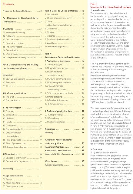
Contents<br />
Preface to the Second Edition . . . . . . . . . 2<br />
Part I Standards for <strong>Geophysical</strong> <strong>Survey</strong><br />
1 Introduction . . . . . . . . . . . . . . . . . . . . . 3<br />
2 Guidance . . . . . . . . . . . . . . . . . . . . . . . . 3<br />
2.1 Justification for survey . . . . . . . . . . . . . . 3<br />
2.2 <strong>Field</strong>work . . . . . . . . . . . . . . . . . . . . . . . . 4<br />
2.3 Data treatment . . . . . . . . . . . . . . . . . . . . 4<br />
2.4 Data <strong>in</strong>terpretation . . . . . . . . . . . . . . . . 4<br />
2.5 The survey report . . . . . . . . . . . . . . . . . 4<br />
2.6 Dissem<strong>in</strong>ation . . . . . . . . . . . . . . . . . . . . . 5<br />
2.7 Data archiv<strong>in</strong>g . . . . . . . . . . . . . . . . . . . . . 5<br />
2.8 Competence of survey personnel . . . . 5<br />
Part II <strong>Geophysical</strong> <strong>Survey</strong> and Plann<strong>in</strong>g<br />
1 Archaeology and plann<strong>in</strong>g . . . . . . . . . . . 6<br />
2 MoRPHE . . . . . . . . . . . . . . . . . . . . . . . . 6<br />
2.1 Start-up and plann<strong>in</strong>g . . . . . . . . . . . . . . 6<br />
2.2 Execution . . . . . . . . . . . . . . . . . . . . . . . . 6<br />
2.3 Closure . . . . . . . . . . . . . . . . . . . . . . . . . . 7<br />
3 Briefs and specifications . . . . . . . . . . . . 7<br />
3.1 The brief . . . . . . . . . . . . . . . . . . . . . . . . . 7<br />
3.2 The specification . . . . . . . . . . . . . . . . . . . 8<br />
4 The survey report . . . . . . . . . . . . . . . . 9<br />
4.1 Summary . . . . . . . . . . . . . . . . . . . . . . . . . 9<br />
4.2 Introduction . . . . . . . . . . . . . . . . . . . . . . 9<br />
4.3 Methods . . . . . . . . . . . . . . . . . . . . . . . . . 9<br />
4.4 Results . . . . . . . . . . . . . . . . . . . . . . . . . . . 9<br />
4.5 Conclusions . . . . . . . . . . . . . . . . . . . . . . . 9<br />
4.6 Site location plan(s) . . . . . . . . . . . . . . . . 9<br />
4.7 Data presentation –<br />
plots and plans . . . . . . . . . . . . . . . . . . . 10<br />
4.8 Plots of raw data . . . . . . . . . . . . . . . . . 10<br />
4.9 Plots of processed data . . . . . . . . . . . . 10<br />
4.10 Interpretative diagrams . . . . . . . . . . . 10<br />
5 Dissem<strong>in</strong>ation . . . . . . . . . . . . . . . . . . . 10<br />
5.1 Sources of <strong>in</strong>formation . . . . . . . . . . . . 10<br />
5.2 Dissem<strong>in</strong>ation requirements . . . . . . . . 11<br />
6 Archiv<strong>in</strong>g . . . . . . . . . . . . . . . . . . . . . . . 11<br />
7 Legal considerations . . . . . . . . . . . . . . 11<br />
7.1 Access . . . . . . . . . . . . . . . . . . . . . . . . . . 11<br />
7.2 Metal detectors . . . . . . . . . . . . . . . . . . 12<br />
7.3 <strong>Geophysical</strong> survey . . . . . . . . . . . . . . . 12<br />
Part III Guide to Choice of Methods . . 13<br />
1 Introduction . . . . . . . . . . . . . . . . . . . . . . . 13<br />
2 Choice of geophysical survey . . . . . . . . 13<br />
3 Costs . . . . . . . . . . . . . . . . . . . . . . . . . . . . 14<br />
4 Urban (and brownfield) sites . . . . . . . . 14<br />
5 Cemeteries . . . . . . . . . . . . . . . . . . . . . . . 15<br />
6 Alluvium . . . . . . . . . . . . . . . . . . . . . . . . . . 16<br />
7 Wetlands . . . . . . . . . . . . . . . . . . . . . . . . . 16<br />
8 Road and pipel<strong>in</strong>e corridors . . . . . . . . . 17<br />
9 W<strong>in</strong>d farms . . . . . . . . . . . . . . . . . . . . . . . 17<br />
10 Extremely large areas . . . . . . . . . . . . . . 18<br />
Part IV<br />
Practitioner’s Guide to Good Practice<br />
1 Application of techniques . . . . . . . . . . 19<br />
1.1 The survey grid . . . . . . . . . . . . . . . . . . . 19<br />
1.2 Magnetometer survey . . . . . . . . . . . . . 20<br />
1.3 Earth resistance<br />
(resistivity) survey . . . . . . . . . . . . . . . . . 24<br />
1.4 Ground penetrat<strong>in</strong>g radar . . . . . . . . . 28<br />
1.5 Electromagnetic methods . . . . . . . . . . 34<br />
1.6 Topsoil magnetic<br />
susceptibility survey . . . . . . . . . . . . . . .36<br />
1.7 Other geophysical methods . . . . . . . . 37<br />
1.8 Metal detect<strong>in</strong>g . . . . . . . . . . . . . . . . . . 40<br />
1.9 Geochemical methods . . . . . . . . . . . . 40<br />
1.10 Remote sens<strong>in</strong>g . . . . . . . . . . . . . . . . . 41<br />
2 Analysis of geophysical data . . . . . . . . 41<br />
2.1 Data process<strong>in</strong>g . . . . . . . . . . . . . . . . . . 41<br />
2.2 Data display . . . . . . . . . . . . . . . . . . . . . 45<br />
2.3 Data <strong>in</strong>terpretation . . . . . . . . . . . . . . . 49<br />
References . . . . . . . . . . . . . . . . . . . . . . . 50<br />
Glossary . . . . . . . . . . . . . . . . . . . . . . . . . 54<br />
Appendix I Related standards,<br />
codes and guidance . . . . . . . . . . . . . . . . 56<br />
Appendix II Contacts . . . . . . . . . . . . . . . 57<br />
Appendix III Useful websites . . . . . . . . . 58<br />
Appendix IV List of consultees . . . . . . . 59<br />
Contributors . . . . . . . . . . . . . . . . . . . . . 60<br />
Acknowledgements . . . . . . . . . . . . . . . . 60<br />
Part I<br />
Standards for <strong>Geophysical</strong> <strong>Survey</strong><br />
1 Introduction<br />
There is currently no formalised standard<br />
for the conduct of geophysical survey <strong>in</strong><br />
archaeological field evaluation. For the purpose<br />
of this guidance, however, it is expected that<br />
such survey will, as far as is reasonably possible,<br />
determ<strong>in</strong>e the nature of the detectable<br />
archaeological resource with<strong>in</strong> a specified area<br />
us<strong>in</strong>g appropriate methods and practices 1 .<br />
These will satisfy the stated aims of the<br />
survey project. Members of the Institute<br />
of <strong>Field</strong> Archaeologists (IFA) will, and other<br />
practitioners should, comply with the Code<br />
of conduct, Code of approved practice for<br />
the regulation of contractual arrangements <strong>in</strong><br />
field archaeology, and other relevant by-laws<br />
of that Institution 2 .<br />
1 All relevant fieldwork must conform to the<br />
Standard and Guidance set out by the Institute<br />
of <strong>Field</strong> Archaeologists for archaeological<br />
field evaluation.<br />
(http://www.archaeologists.net/modules/<br />
icontent/<strong>in</strong>Pages/docs/codes/fldeval2001.pdf)<br />
2 The IFA is the professional body for<br />
archaeologists <strong>in</strong> the United K<strong>in</strong>gdom<br />
(www.archaeologists.net). It exists to advance<br />
the practice of archaeology and allied discipl<strong>in</strong>es<br />
by promot<strong>in</strong>g professional standards and ethics<br />
for conserv<strong>in</strong>g, manag<strong>in</strong>g, understand<strong>in</strong>g and<br />
promot<strong>in</strong>g enjoyment of heritage. It has about<br />
2500 members <strong>in</strong> the UK and abroad.<br />
This basic requirement for geophysical survey<br />
<strong>in</strong> archaeology is fairly straightforward, although<br />
much will depend on the def<strong>in</strong>ition of what<br />
is ‘reasonably possible’. To help address this,<br />
we <strong>in</strong>itially itemise below some more precise<br />
requirements that must be achieved; followed<br />
<strong>in</strong> Parts II–IV by more specific guidance on<br />
best practice. Part II (<strong>Geophysical</strong> <strong>Survey</strong> and<br />
Plann<strong>in</strong>g) and Part III (Guide to the Choice of<br />
Methods) are aimed at those who commission<br />
surveys; Part IV is a more <strong>in</strong>-depth description<br />
and assessment of the ma<strong>in</strong> methodologies,<br />
for those more concerned with these.<br />
2 Guidance<br />
2.1 Justification for survey<br />
Prior to fieldwork, the geophysical survey<br />
requirements must be <strong>in</strong>tegrated with<strong>in</strong><br />
a written statement (the project design,<br />
specification, written scheme of <strong>in</strong>vestigation, or<br />
survey contract). This must <strong>in</strong>clude an explicit<br />
justification for the choice of survey methodology,<br />
while reta<strong>in</strong><strong>in</strong>g some flexibility should this require<br />
modification <strong>in</strong> the light of particular site<br />
conditions at the time of fieldwork. The choice<br />
of survey methodology will be appropriately<br />
matched both with the archaeological and<br />
logistical demands of the project.<br />
3