Geophysical Survey in Archaeological Field Evaluation - HELM
Geophysical Survey in Archaeological Field Evaluation - HELM
Geophysical Survey in Archaeological Field Evaluation - HELM

You also want an ePaper? Increase the reach of your titles
YUMPU automatically turns print PDFs into web optimized ePapers that Google loves.
measurements have been used to successfully<br />
determ<strong>in</strong>e significant anomalies beneath<br />
surface deposits across wider landscapes<br />
(eg Dalan and Banerjee 1996).<br />
1.7 Other geophysical methods<br />
Despite offer<strong>in</strong>g limited use for traditional<br />
applications of archaeological evaluation a wide<br />
range of additional geophysical techniques is<br />
available that may, under certa<strong>in</strong> conditions, be<br />
applicable. Some of the techniques discussed<br />
<strong>in</strong> this section are highly specific – for example<br />
the use of micro-gravity for the detection of<br />
buried voids – while other techniques propose<br />
new means for obta<strong>in</strong><strong>in</strong>g data-sets comparable<br />
with more traditional methods. Most of these<br />
latter techniques are currently at a stage<br />
of development between research and full<br />
commercial deployment, but may well be<br />
adopted as the technology matures <strong>in</strong> the<br />
near future.<br />
1.7.1 Capacitative arrays<br />
These systems are designed for the rapid<br />
acquisition of apparent resistivity data and use<br />
a series of electrodes mounted on <strong>in</strong>dividual<br />
<strong>in</strong>sulat<strong>in</strong>g mats that may be towed rapidly<br />
across a site without the need to obta<strong>in</strong> a<br />
direct contact with the ground surface. The<br />
electric potential produced by the charges<br />
on the electrodes causes the movement of<br />
charged particles <strong>in</strong> the ground result<strong>in</strong>g <strong>in</strong> a<br />
brief capacitative coupl<strong>in</strong>g, cont<strong>in</strong>u<strong>in</strong>g only until<br />
an equal and opposite reverse potential has<br />
been established <strong>in</strong> the subsurface. Use of a<br />
sufficiently high frequency source will reverse<br />
the flow of charged particles <strong>in</strong> the ground,<br />
a) b)<br />
produc<strong>in</strong>g an alternat<strong>in</strong>g current <strong>in</strong> the<br />
subsurface. Similar dipolar pairs of <strong>in</strong>sulated<br />
electrodes are then used to measure the<br />
potential created by the ground current.<br />
Multiple potential electrodes can be towed<br />
at different spac<strong>in</strong>gs beh<strong>in</strong>d the current<br />
electrodes to simultaneously measure the<br />
apparent resistivity at vary<strong>in</strong>g depths and can<br />
be <strong>in</strong>verted to provide a pseudo-section of<br />
the ground surface (see above, section 1.3.4).<br />
However, at higher source frequencies,<br />
attenuation of the signal may prove to be a<br />
limit<strong>in</strong>g factor and the depth of <strong>in</strong>vestigation<br />
restricted by the electrical sk<strong>in</strong> depth. Currently,<br />
these <strong>in</strong>struments seem to be ideally suited to<br />
rapid, large-scale, reconnaissance surveys for<br />
the detection of more deep-ly<strong>in</strong>g archaeological<br />
or geomorphological features, but may yet<br />
challenge the quality of traditional earth<br />
resistance data for very near surface targets.<br />
Rough or uneven ground conditions can be<br />
problematic, caus<strong>in</strong>g poor coupl<strong>in</strong>g between<br />
the <strong>in</strong>sulat<strong>in</strong>g electrodes and the subsurface.<br />
1.7.2 Seismic methods<br />
Seismic methods use low energy acoustic<br />
waves transmitted by vibration through the<br />
host medium and can be used effectively <strong>in</strong><br />
both mar<strong>in</strong>e and terrestrial environments.<br />
Velocities of seismic waves vary from c 200m/s<br />
<strong>in</strong> soil up to 7000m/s <strong>in</strong> solid geological units<br />
and, at the frequencies deployed, can result<br />
<strong>in</strong> relatively long wavelengths, generally >1m.<br />
This restricts the archaeological application<br />
of seismic methods to relatively large-scale<br />
features. For shallow, terrestrial, <strong>in</strong>vestigations<br />
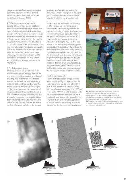
Fig 20 (below) Area magnetic susceptibility survey (a)<br />
show<strong>in</strong>g <strong>in</strong>creased response over an area of dense<br />
magnetometer anomalies (b). Low responses to the NE<br />
correlate with recent soil dump<strong>in</strong>g, but some f<strong>in</strong>er detail is<br />
not represented, such as a cemetery (c).<br />
Fig 21 (above) Bart<strong>in</strong>gton MS2 magnetic susceptibility meter<br />
<strong>in</strong> use: (a) <strong>in</strong> the laboratory with collected 10g soil samples<br />
and; (b) on site with a field coil.<br />
c)<br />
37