Geophysical Survey in Archaeological Field Evaluation - HELM
Geophysical Survey in Archaeological Field Evaluation - HELM
Geophysical Survey in Archaeological Field Evaluation - HELM

You also want an ePaper? Increase the reach of your titles
YUMPU automatically turns print PDFs into web optimized ePapers that Google loves.
the subject of methodological research, or they<br />
are used to assist <strong>in</strong>terpretation at an <strong>in</strong>tra-site<br />
scale of <strong>in</strong>vestigation. A review of geochemical<br />
methods is provided by Heron (2001); see<br />
also English Heritage (2007).<br />
1.10 Remote sens<strong>in</strong>g<br />
Remote sens<strong>in</strong>g is def<strong>in</strong>ed as the imag<strong>in</strong>g of<br />
phenomena from a distance (Shennan and<br />
Donoghue 1992) and is here considered to<br />
be dist<strong>in</strong>ct from the ground-based remote<br />
sens<strong>in</strong>g methods so far discussed.<br />
1.10.1 Aerial photography<br />
Aerial photography (AP) is the most familiar<br />
remote sens<strong>in</strong>g technique (Bewley 1993;<br />
Bewley and Raczklowski 2002; Palmer and Cox<br />
1993; Wilson 2000) and the aerial photographic<br />
record should always be consulted as part<br />
of site evaluation. This record is often highly<br />
complementary to that obta<strong>in</strong>ed by geophysical<br />
methods. In many circumstances the AP record<br />
will dictate where ground-based methods may<br />
be deployed and the latter will often provide<br />
exact ground location as well as additional<br />
def<strong>in</strong>ition and detail. <strong>Geophysical</strong> methods may<br />
be able to respond positively where the AP<br />
record is negative, or where surface conditions<br />
are unsuitable for photography.<br />
1.10.2 Multi-spectral scann<strong>in</strong>g<br />
Despite the <strong>in</strong>creas<strong>in</strong>g availability of higherresolution<br />
data achieved by airborne multispectral<br />
scann<strong>in</strong>g (MSS) – from sensors mounted<br />
on satellites and on aircraft – this has still not<br />
made much impact <strong>in</strong> the day-to-day evaluation<br />
<strong>in</strong> the UK of sites for their archaeological<br />
content. A review of the subject has been<br />
provided by Donoghue (2001), and examples of<br />
case studies <strong>in</strong>clude Fowler (2002), Powlesland<br />
et al (1997), Shennan and Donoghue (1992),<br />
and W<strong>in</strong>terbottom and Dawson (2005).<br />
1.10.3 Remote surface mapp<strong>in</strong>g<br />
Modern remote imag<strong>in</strong>g systems are now able<br />
to capture <strong>in</strong>creas<strong>in</strong>gly detailed and accurate<br />
topographic <strong>in</strong>formation at a variety of scales<br />
relevant to archaeological prospection. While<br />
digital aerial photogrammetry has seen some<br />
application (Stone et al 2004), attention is<br />
currently focused on the considerable potential<br />
offered by lidar (light direction and rang<strong>in</strong>g),<br />
and <strong>in</strong>terferometric synthetic aperture<br />
radar (IFSAR).<br />
Of these, lidar currently offers the higher level<br />
of vertical and horizontal resolution (Crutchley<br />
2006; Holden et al 2002), and the result<strong>in</strong>g<br />
digital surface models (DSMs) can be<br />
manipulated to enhance the recognition of<br />
very slight but significant surface topography<br />
(Bewley et al 2005). A significant advantage<br />
over aerial photography is the potential ability<br />
to digitally remove tree cover to create digital<br />
terra<strong>in</strong> models (DTMs) of underly<strong>in</strong>g earthwork<br />
features (Devereux et al 2005). The value to<br />
archaeological evaluation of IFSAR is presently<br />
less clear, although elevation data for all of<br />
Brita<strong>in</strong> is available at http://www.<strong>in</strong>termap.com/<br />
corporate/greatBrit.cfm.<br />
2 Analysis of geophysical data<br />
2.1 Data process<strong>in</strong>g<br />
Once geophysical data has been collected it<br />
is necessary to process it for <strong>in</strong>terpretation<br />
and presentation. The advent of powerful and<br />
affordable personal comput<strong>in</strong>g equipment has<br />
revolutionised this aspect of archaeological<br />
geophysics over the last fifteen years and several<br />
specialised software packages are now available<br />
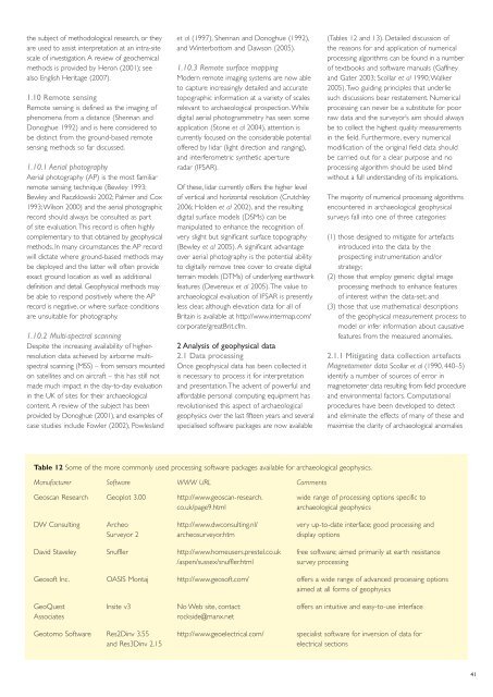
Table 12 Some of the more commonly used process<strong>in</strong>g software packages available for archaeological geophysics.<br />
Manufacturer Software WWW URL Comments<br />
(Tables 12 and 13). Detailed discussion of<br />
the reasons for and application of numerical<br />
process<strong>in</strong>g algorithms can be found <strong>in</strong> a number<br />
of textbooks and software manuals (Gaffney<br />
and Gater 2003; Scollar et al 1990; Walker<br />
2005). Two guid<strong>in</strong>g pr<strong>in</strong>ciples that underlie<br />
such discussions bear restatement. Numerical<br />
process<strong>in</strong>g can never be a substitute for poor<br />
raw data and the surveyor’s aim should always<br />
be to collect the highest quality measurements<br />
<strong>in</strong> the field. Furthermore, every numerical<br />
modification of the orig<strong>in</strong>al field data should<br />
be carried out for a clear purpose and no<br />
process<strong>in</strong>g algorithm should be used bl<strong>in</strong>d<br />
without a full understand<strong>in</strong>g of its implications.<br />
The majority of numerical process<strong>in</strong>g algorithms<br />
encountered <strong>in</strong> archaeological geophysical<br />
surveys fall <strong>in</strong>to one of three categories:<br />
(1) those designed to mitigate for artefacts<br />
<strong>in</strong>troduced <strong>in</strong>to the data by the<br />
prospect<strong>in</strong>g <strong>in</strong>strumentation and/or<br />
strategy;<br />
(2) those that employ generic digital image<br />
process<strong>in</strong>g methods to enhance features<br />
of <strong>in</strong>terest with<strong>in</strong> the data-set; and<br />
(3) those that use mathematical descriptions<br />
of the geophysical measurement process to<br />
model or <strong>in</strong>fer <strong>in</strong>formation about causative<br />
features from the measured anomalies.<br />
2.1.1 Mitigat<strong>in</strong>g data collection artefacts<br />
Magnetometer data Scollar et al (1990, 440–5)<br />
identify a number of sources of error <strong>in</strong><br />
magnetometer data result<strong>in</strong>g from field procedure<br />
and environmental factors. Computational<br />
procedures have been developed to detect<br />
and elim<strong>in</strong>ate the effects of many of these and<br />
maximise the clarity of archaeological anomalies<br />
Geoscan Research Geoplot 3.00 http://www.geoscan-research. wide range of process<strong>in</strong>g options specific to<br />
co.uk/page9.html archaeological geophysics<br />
DW Consult<strong>in</strong>g Archeo http://www.dwconsult<strong>in</strong>g.nl/ very up-to-date <strong>in</strong>terface; good process<strong>in</strong>g and<br />
<strong>Survey</strong>or 2 archeosurveyor.htm display options<br />
David Staveley Snuffler http://www.homeusers.prestel.co.uk free software; aimed primarily at earth resistance<br />
/aspen/sussex/snuffler.html survey process<strong>in</strong>g<br />
Geosoft Inc. OASIS Montaj http://www.geosoft.com/ offers a wide range of advanced process<strong>in</strong>g options<br />
aimed at all forms of geophysics<br />
GeoQuest Insite v3 No Web site, contact: offers an <strong>in</strong>tuitive and easy-to-use <strong>in</strong>terface<br />
Associates rockside@manx.net<br />
Geotomo Software Res2D<strong>in</strong>v 3.55 http://www.geoelectrical.com/ specialist software for <strong>in</strong>version of data for<br />
and Res3D<strong>in</strong>v 2.15 electrical sections<br />
41