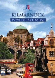
Integrated Urban Development Plan (pdf) - Make It Kilmarnock
Integrated Urban Development Plan (pdf) - Make It Kilmarnock
Integrated Urban Development Plan (pdf) - Make It Kilmarnock

You also want an ePaper? Increase the reach of your titles
YUMPU automatically turns print PDFs into web optimized ePapers that Google loves.
The conservation area provides some of the highest quality<br />
environments in <strong>Kilmarnock</strong>. The fact that the conservation<br />
area designation includes both sides of John Finnie Street<br />
and extends west from there to include a range of mixed use<br />
properties means that although the street is part of the oneway<br />
system, it is rather less intrusive and difficult to cross<br />
that other parts of the gyratory. However John Finnie Street<br />
is in need of considerable improvement if it is to become<br />
not only a significant planned street with good architecture<br />
but also a social space where people congregate and feel<br />
comfortable.<br />
River and greenspace:<br />
One of <strong>Kilmarnock</strong>’s undiscovered gems is the <strong>Kilmarnock</strong><br />
Water which flows through the town centre from north to<br />
south. Many attractive towns and cities are famous for their<br />
relationship with a river or waterway. Usually the town has<br />
embraced the river in some form and provides a means of<br />
accessing its banks or simply watching the water – this in<br />
turn attracts people to the river and often encourages the<br />
development of promenade cafes and social spaces.<br />
The <strong>Kilmarnock</strong> Water and Sandbed Street<br />
In contrast, the <strong>Kilmarnock</strong> Water is largely hidden from<br />
view. The Burns Mall shopping centre is built over it there are<br />
no views of it from King Street or Bank Street. Three bridges<br />
and Sandbed Street provide the only means of getting close<br />
to the river. At the same time just beyond the town centre<br />
to the north east, the <strong>Kilmarnock</strong> Water flows through Kay<br />
Park until it disappears behind the Palace Theatre. In the<br />
south west, the river opens out into Howard Park providing a<br />
picturesque focus for this popular greenspace.<br />
There is enormous potential to establish a more positive<br />
relationship between the town centre and the <strong>Kilmarnock</strong><br />
Water in which the river becomes a more obvious and<br />
integral part of a high quality town centre environment. A<br />
more positive relationship might also involve using the river<br />
to improve connections with the town centre and the rest of<br />
the town through a series of comfortable pedestrian spaces<br />
and linking footpaths. Such a footpath system could also<br />
encompass a wider green network throughout the town. In<br />
other words, the blue and green network traced out by the<br />
<strong>Kilmarnock</strong> Water and the existing parks and Core Paths<br />
could be enlarged and integrated into a town-wide system<br />
focused on links to the town centre. Such a network would<br />
link people, places and habitats.<br />
12 | MAKE IT KILMARNOCK BOARD | EAST AYRSHIRE COUNCIL