KÑига LXXII
KÑига LXXII
KÑига LXXII

You also want an ePaper? Increase the reach of your titles
YUMPU automatically turns print PDFs into web optimized ePapers that Google loves.
Prospects for wider energetic utilization of subgeothermal water resources: eastern Serbia case study 133<br />
are registered, 2/3 of them with water temperatures<br />
over 20ºC. Most of the thermal waters are used for<br />
balneology and just a few for heating purposes. In<br />
contrast, in neighboring Hungary thermal flows are<br />
tapped for heating purposes in many locations. A good<br />
example is Hodmezovasarhely where 50000 inhabitants<br />
get their heat from the thermal waters at 80ºC,<br />
tapped at a depth of 2000 m (75 % of utilized waters<br />
are reinjected into the ground).<br />
Recently conducted studies aiming to assess the thermal<br />
potential of lower temperature ground sources in<br />
Serbia introduced the term “subgeothermal resources”<br />
(STEVANOVIĆ et al. 2008). It has been proposed that<br />
waters with a temperature of 30ºC or lower are to be<br />
classified in this group whereas those with a temperature<br />
of 30–100ºC belong to “geothermal resources”.<br />
One of the explanations is very practical: although<br />
GSHP is necessary for water with lower temperatures,<br />
the panel radiator systems allow direct use of water<br />
with a temperature of 30ºC or more without GSHP.<br />
However, as temperatures are lower, heating panels<br />
with larger surfaces are required.<br />
Subgeothermal fluids in the territory of Serbia are<br />
typical of complex geology as well as of a moderate<br />
continental climate. They are classified as follows<br />
(Таble 1):<br />
Таble 1. Energetic potential of subgeothermal sources.<br />
Brief physio geography, geology and<br />
hydrogeology of the study area<br />
There were several reasons to choose the Carpathian<br />
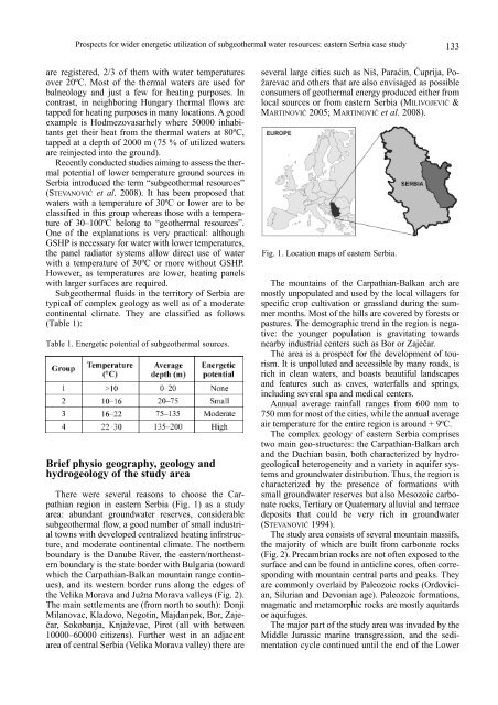
region in eastern Serbia (Fig. 1) as a study<br />
area: abundant groundwater reserves, considerable<br />
subgeothermal flow, a good number of small industrial<br />
towns with developed centralized heating infrstructure,<br />
and moderate continental climate. The northern<br />
boundary is the Danube River, the eastern/northeastern<br />
boundary is the state border with Bulgaria (toward<br />
which the Carpathian-Balkan mountain range continues),<br />
and its western border runs along the edges of<br />
the Velika Morava and Južna Morava valleys (Fig. 2).<br />
The main settlements are (from north to south): Donji<br />
Milanovac, Kladovo, Negotin, Majdanpek, Bor, Zaječar,<br />
Sokobanja, Knjaževac, Pirot (all with between<br />
10000–60000 citizens). Further west in an adjacent<br />
area of central Serbia (Velika Morava valley) there are<br />
several large cities such as Niš, Paraćin, Ćuprija, Požarevac<br />
and others that are also envisaged as possible<br />
consumers of geothermal energy produced either from<br />
local sources or from eastern Serbia (MILIVOJEVIĆ &<br />
MARTINOVIĆ 2005; MARTINOVIĆ et al. 2008).<br />
Fig. 1. Location maps of eastern Serbia.<br />
The mountains of the Carpathian-Balkan arch are<br />
mostly unpopulated and used by the local villagers for<br />
specific crop cultivation or grassland during the summer<br />
months. Most of the hills are covered by forests or<br />
pastures. The demographic trend in the region is negative:<br />
the younger population is gravitating towards<br />
nearby industrial centers such as Bor or Zaječar.<br />
The area is a prospect for the development of tourism.<br />
It is unpolluted and accessible by many roads, is<br />
rich in clean waters, and boasts beautiful landscapes<br />
and features such as caves, waterfalls and springs,<br />
including several spa and medical centers.<br />
Annual average rainfall ranges from 600 mm to<br />
750 mm for most of the cities, while the annual average<br />
air temperature for the entire region is around + 9ºC.<br />
The complex geology of eastern Serbia comprises<br />
two main geo-structures: the Carpathian-Balkan arch<br />
and the Dachian basin, both characterized by hydrogeological<br />
heterogeneity and a variety in aquifer systems<br />
and groundwater distribution. Thus, the region is<br />
characterized by the presence of formations with<br />
small groundwater reserves but also Mesozoic carbonate<br />
rocks, Tertiary or Quaternary alluvial and terrace<br />
deposits that could be very rich in groundwater<br />
(STEVANOVIĆ 1994).<br />
The study area consists of several mountain massifs,<br />
the majority of which are built from carbonate rocks<br />
(Fig. 2). Precambrian rocks are not often exposed to the<br />
surface and can be found in anticline cores, often corresponding<br />
with mountain central parts and peaks. They<br />
are commonly overlaid by Paleozoic rocks (Ordovician,<br />
Silurian and Devonian age). Paleozoic formations,<br />
magmatic and metamorphic rocks are mostly aquitards<br />
or aquifuges.<br />
The major part of the study area was invaded by the<br />
Middle Jurassic marine transgression, and the sedimentation<br />
cycle continued until the end of the Lower