KÑига LXXII
KÑига LXXII
KÑига LXXII

You also want an ePaper? Increase the reach of your titles
YUMPU automatically turns print PDFs into web optimized ePapers that Google loves.
Involutina farinacciae BRONNIMANN & KOEHN-ZANINETTI 1969, a marker for the Middle Liassic 51<br />
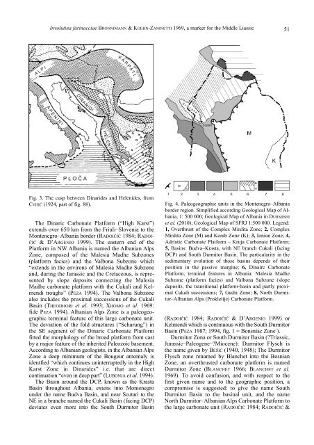
Fig. 3. The cusp between Dinarides and Helenides, from<br />
CVIJIĆ (1924, part of fig. 88).<br />
The Dinaric Carbonate Platform (“High Karst”)<br />
extends over 650 km from the Friuli–Slovenia to the<br />
Montenegro–Albania border (RADOIČIĆ 1984; RADOI-<br />
ČIĆ & D’ARGENIO 1999). The eastern end of the<br />
Platform in NW Albania is named the Albanian Alps<br />
Zone, composed of the Malesia Madhe Subzones<br />
(platform facies) and the Valbona Subzone which<br />
“extends in the environs of Malesia Madhe Subzone<br />
and, during the Jurassic and the Cretaceous, is represented<br />
by slope deposits connecting the Malesia<br />
Madhe carbonate platform with the Cukali and Kelmendi<br />
troughs” (PEZA 1994). The Valbona Subzone<br />
also includes the proximal successions of the Cukali<br />
Basin (THEODHORI et al. 1993; XHOMO et al. 1969:<br />
fide PEZA 1994). Albanian Alps Zone is a paleogeographic<br />
terminal feature of this large carbonate unit.<br />
The deviation of the fold structures (“Scharung”) in<br />
the SE segment of the Dinaric Carbonate Platform<br />
fitted the morphology of the broad platform front cast<br />
by a major feature of the inherited Paleozoic basement.<br />
According to Albanian geologists, in the Albanian Alps<br />
Zone a deep minimum of the Bougeur amomaly is<br />
identfied “which continues uninterruptedly in the High<br />
Karst Zone in Dinarides” i.e. that are direct<br />
continuation “even in deep part” (LUBONJA et al. 1994).<br />
The Basin around the DCP, known as the Krasta<br />
Basin throughout Albania, extens into Montenegro<br />
under the name Budva Basin, and near Scutari to the<br />
NE in a branche named the Cukali Basin (facing DCP)<br />
deviates even more into the South Durmitor Basin<br />
Fig. 4. Paleogeographic units in the Montenegro–Albania<br />
border region. Simplified according Geological Map of Albania,<br />
1: 500 000; Geological Map of Albania in DURMISHI<br />
et al. (2010); Geological Map of SFRJ 1:500 000. Legend:<br />
1, Overthrust of the Complex Mirdita Zone; 2, Complex<br />
Mirdita Zone (M) and Korab Zone (K); 3, Ionian Zone; 4,<br />
Adriatic Carbonate Platform – Kruja Carbonate Platform;<br />
5, Basins: Budva–Krasta, with NE branch Cukali (facing<br />
DCP) and South Durmitor Basin. The particularity in the<br />
sedimentary evolution of those basins depends of their<br />
position in the passive margine; 6, Dinairc Carbonate<br />
Platform, terminal features in Albania: Malesia Madhe<br />
Subzone (platform facies) and Valbona Subzone (slope<br />
deposits, the transitional platform-basin and partly proximal<br />
Cukali successions; 7, Gashi Zone; 8, North Durmitor–Albanian<br />
Alps (Prokletije) Carbonate Platform.<br />
(RADOIČIĆ 1984; RADOIČIĆ & D’ARGENIO 1999) or<br />
Kelmendi which is continuous with the South Durmitor<br />
Basin (PEZA 1987; 1994, fig. 1 = Bonsniac Zone ).<br />
Durmitor Zona or South Durmitor Basin (?Triassic,<br />
Jurassic–Paleogene–?Miocene): Durmitor Flysch is<br />
the name given by BEŠIĆ (1940, 1948); The Durmitor<br />
Flysch zone renamed by Blanchet into the Bosnian<br />
Zone, an overthrusted carbonate platform is named<br />
Durmitor Zone (BLANCHET 1966; BLANCHET et al.<br />
1969). To avoid confusion, and with respect to the<br />
first given name and to the geographic position, a<br />
compromise is suggested: to give the name South<br />
Durmitor Basin to the basinal unit, and the name<br />
North Durmitor–Albanian Alps Carbonate Platform to<br />
the large carbonate unit (RADOIČIĆ 1984; RADOIČIĆ &