KÑига LXXII
KÑига LXXII
KÑига LXXII

Create successful ePaper yourself
Turn your PDF publications into a flip-book with our unique Google optimized e-Paper software.
146<br />
DUŠAN POLOMČIĆ, OLIVERA KRUNIĆ & VESNA RISTIĆ-VAKANJAC<br />
and III (Fig. 2). The thickness and depth of some waterbearing<br />
layers were determined based on data obtained<br />
by well drilling and logging measurements in the<br />
majority of the wells and are presented in Table 1.<br />
Table. 1. Thickness of water-bearing layers in wider study<br />
area.<br />
on general knowledge of the geological and hydrogeological<br />
features of the terrain and head loss analysis<br />
over a long period of time. The overlying layer of the<br />
water-bearing layer I is comprised of loess, sand,<br />
clayey sand and sandy clay. Partial precipitation infiltration<br />
into the water-bearing layer I is allowed by<br />
such a lithological composition. Infiltration certainly<br />
occurs very slowly and in complex ways. As the<br />
aquifer is distributed regionally, recharging occurs<br />
over a wider area where water permeable sediments<br />
prevail in the overlying layer or in zones where the<br />
aquifer communicates directly with the surface of the<br />
terrain or river flows.<br />
The aquifer is drained by about 70 wells distributed<br />
over the area with a diameter of 15–20 km: by the town<br />
source in Bečej, Novi Bečej, Bačko Petrovo Selo, Veliko<br />
Gradište and other minor settlements, as well as by<br />
the factories: Sojaprotein, Linde–Gas, Agricultural Industrial<br />
Company Bečej and the companies: Agroprodukt<br />
Šinković, etc.<br />
The water-bearing layers I, II and III are separated<br />
by packages of clay and sandy clay with the thickness<br />
of 5–20 m. This insulation is not complete and allows<br />
partial hydraulic communication and the construction<br />
of an aquifer with the table under pressure. Additionally,<br />
northwest in the area of the Linde Gas Source,<br />
the water-bearing horizons of I and II merge into one.<br />
All this indicates a complex hydrodynamic whole.<br />
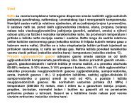
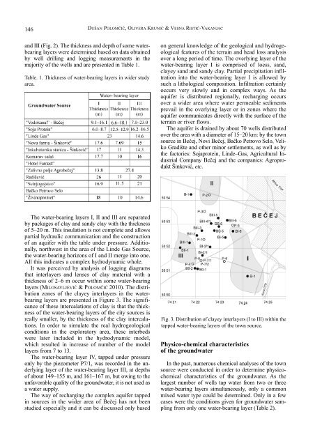
It was perceived by analysis of logging diagrams<br />
that interlayers and lenses of clay material with a<br />
thickness of 2–6 m occur within some water-bearing<br />
layers (MILOSAVLJEVIĆ & POLOMČIĆ 2010). The distribution<br />
zones of the clayey interlayers in the waterbearing<br />
layers are presented in Figure 3. The significance<br />
of these intercalations of clay is that the thickness<br />
of the water-bearing layers of the city sources is<br />
really smaller, by the thickness of the clay intercalations.<br />
In order to simulate the real hydrogeological<br />
conditions in the exploratory area, these interbeds<br />
were later included in the hydrodynamic model,<br />
which resulted in increase of number of the model<br />
layers from 7 to 13.<br />
The water-bearing layer IV, tapped under pressure<br />
only by the piezometer P7/1, was recorded in the underlying<br />
layer of the water-bearing layer III, at depths<br />
of about 149–155 m, and 161–167 m, but owing to the<br />
unfavorable quality of the groundwater, it is not used as<br />
a water supply.<br />
The way of recharging the complex aquifer tapped<br />
in sources in the wider area of Bečej has not been<br />
studied especially and it can be discussed only based<br />
Fig. 3. Distribution of clayey interlayers (I to III) within the<br />
tapped water-bearing layers of the town source.<br />
Physico-chemical characteristics<br />
of the groundwater<br />
In the past, numerous chemical analyses of the town<br />
source were conducted in order to determine physicochemical<br />
characteristics of the groundwater. As the<br />
largest number of wells tap water from two or three<br />
water-bearing layers simultaneously, only a common<br />
mixed water type could be determined. Only in a few<br />
cases were the conditions given for groundwater sampling<br />
from only one water-bearing layer (Table 2).