Ormond Scenic Loop & Trail - Florida Scenic Highways
Ormond Scenic Loop & Trail - Florida Scenic Highways
Ormond Scenic Loop & Trail - Florida Scenic Highways

You also want an ePaper? Increase the reach of your titles
YUMPU automatically turns print PDFs into web optimized ePapers that Google loves.
<strong>Ormond</strong> <strong>Scenic</strong> <strong>Loop</strong> & <strong>Trail</strong> – Corridor Management Plan<br />
96<br />
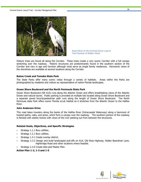
Wood Stork on the <strong>Ormond</strong> <strong>Scenic</strong> <strong>Loop</strong> &<br />
<strong>Trail</strong> Courtesy of Walker Fisher<br />
Historic trees are found all along the Corridor. These trees create a very scenic Corridor with a full canopy<br />
stretching over the roadway. Historic structures are predominantly found in the southern section of the<br />
Corridor and vary in age and function although most serve as single family residences. Panoramic views of<br />
the shorelines are available at several locations along the Corridor.<br />
Bulow Creek and Tomoka State Park<br />
The State Parks offer many scenic vistas through a variety of habitats. Areas within the Parks are<br />
photographed by residents and visitors as representative of native <strong>Florida</strong> landscapes.<br />
Ocean Shore Boulevard and the North Peninsula State Park<br />
Ocean Shore Boulevard (SR A1A) runs along the Atlantic Ocean and offers breathtaking views of the Atlantic<br />
Ocean and natural dunes. Public parking is provided at multiple lots located along Ocean Shore Boulevard and<br />
a separate paved bicycle/pedestrian path runs along the length of Ocean Shore Boulevard. The North<br />
Peninsula state Park offers scenic <strong>Florida</strong> scrub habitat as it stretches from the Atlantic Ocean to the Halifax<br />
River.<br />
John Anderson Drive<br />
This road takes travelers along the banks of the Halifax River (Intracoastal Waterway) along a hammock of<br />
twisted palms, oaks, and pines, which form a canopy over the roadway. The southern portion of the roadway<br />
is flanked with stately homes with views of the river peeking out from between the structures.<br />
Related Goals, Objectives, and Specific Strategies<br />
Strategy 1.1.1 Bury utilities.<br />
Strategy 1.2.1 Bury utilities.<br />
Strategy 1.4.1 Create overlay district.<br />
Strategy 2.3.2 Design and build landscaped pull-offs on A1A, Old Dixie Highway, Walter Boardman Lane,<br />
Highbridge Road and other locations where feasible.<br />
Strategy 2.3.6 Create bike-ped Master Plan.<br />
Action Plan 1-2, 1-3 and 1-5